Embed Size (px)
Citation preview

Community Plan
The
JEFFERSON COUNTY, COLORADO, PLANNING AND ZONING DEPARTMENT

NorthMountainsCommunityPlan Area
Central Mountains
Community Plan Area
North PlainsCommunityPlan Area
SouthJeffersonCountyCommunityPlan Area
Conifer/285CorridorCommunityPlan Area
EvergreenCommunityPlan Area
Broomfield
Westminster
Arvada
Wheat Ridge
Lakewood
Golden
Morrison
Evergreen
Conifer
Foxton
Pike National Forest
River
PlatteSouth
Pine
DeerSouth
Cre
ek
Deer Creek Canyon Rd.
W.
C-470
Creek
Turkey
Park
Cou
nty
Cle
ar C
reek
Cou
nty
Gilp
in C
ount
y
Boulder County
Adam
s County
City &
County of D
enverDouglas
Arapahoe C
ounty
County
Edgewater
LakesideMountain
View
Superior
Cre
ek
Bear
Hwy.
Hwy. 285
285
Ch
at f
ield
BearCreekLake
Lake
Ken Caryl Ave.
W. Hampden
C-470
Hwy.
73
Hwy.
74
Hwy. 6Clear
Creek
I - 70
I - 70
Golden GateCanyon
Rd.
Van CreekBibber
Ra ls tonRes.
Hwy.
93
Hwy.
93
CreekCoalHwy.
72
Wad
swor
thBl
vd.
Wad
swor
thBl
vd.
w. 6th Ave.
w. Colfax Ave.
w. Alameda Ave.
I - 7
0
Creek
Ralston
Bow Mar
CentralMountains
Community Planin relationship to other
community plans, JeffersonCounty and it's
neighboringcounties

Community Plan
The
Beginning in June 1989, the Commu-nity Advisory Group and JeffersonCounty Planning Department projectteam began the planning process todraft the Central Mountains Commu-nity Plan to serve as a guide for futuredevelopment.Members of the project team includedJulie Woods, Project Manager, andJonathan Moore, Staff Advocate. DoyleHarrison was responsible for the docu-ment production. Special appreciationgoes to Phyllis Scheneman, ProjectSecretary and to Jo Blakey and LisaVernon for their excellent secretarialsupport.Other County departments which con-tributed to the development of this Planinclude Highways and Transportation,Health and Environment, Mapping, andthe County Attorney’s office. Withoutthis interdepartmental cooperation itwould not have been possible to pro-
duce this Plan. Individuals within thesedepartments who deserve recognition:Gay Ummel, Jean Ayars and ClaireLevy, County Attorney’s Office; JeanMontoya, Highways and Transporta-tion; Penny Boyd, Jenny Redmond andGary Studwell, Mapping Department;and Mindy Ramig, Health and Environ-mental Services. A high level of sup-port was given by the Jefferson CountyBoard of County Commissioners,Jefferson County Planning Commis-sion, and those overseeing the projectwho included: Terry Green, Director ofAdministrative Services; RichardTurner, Planning Director; and JosephT. Crain, Community Planning Super-visor and former Acting Planning Di-rector for a good share of the planningprocess. Planning Department staffproviding technical assistance includedMike Kortendick, Christy Clark, JackWilliamson, Kevin Nichols, Doug Reed,Janet Stromberg, and Karen Hellner.
Public agencies, commissions and or-ganizations were asked to provide in-formation from the inception throughfinal Plan review prior to the PlanningCommission Public Hearings. Thecooperation of these organizations wasan important aspect of the CentralMountains planning effort. They in-cluded:
Colorado State Forest ServiceJefferson County Historical
CommissionColorado Division of Water
ResourcesColorado Division of WildlifeJefferson County Sheriff’s
DepartmentJefferson Soil Conservation DistrictDenver Regional Council of
GovernmentsPublic Service Company of ColoradoDenver Water Board
Denver Department of Parks andRecreation
Genesee FoundationNewspaper coverage by The GoldenTranscript, The Canyon Courier, andThe Denver Post provided informationto community residents and other in-terested parties throughout the plan-ning process. The project was aidedby the cooperation of the Mount VernonCountry Club, the Idledale CommunityChurch and the Genesee Foundation,all of which provided public meetinglocations.The Plan benefitted from the participa-tion of the many concerned residentsof the Central Mountains area whocompleted questionnaires, wrote let-ters and testified at public hearingsand took time to attend the CommunityAdvisory Group meetings, public meet-ings and hearings. •
ACKNOWLEDGEMENTS
Introduction6 Central Mountains History
11 Profile of the Community
13 Community Advisory GroupRecommendations
14 How to Use this Plan
Preservation Resources15 Geological, Paleontological, Archaeological &
Historical Resources
17 Visual Resources
21 Open Space, Trails & Recreation
28 Wildlife
Critical Limiting Factors30 Air, Odor & Noise
33 Hazards
38 Public Services & Facilities
41 Water & Sanitation
Future Development43 Housing
46 Commercial & Office Development
49 Transportation
53 Mountain Site Design Criteria56 Appendix62 Glossary63 Maps• 3-D Model• Visual Resources• Bear Creek Canyon & Colorado
Highway 26/County Highway 93• Clear Creek Canyon• I-70 & U.S. Highway 40• Historic• Existing Land Use
• Open Space, Public Lands,Trails & Recreation
• Wildlife• Slope• Wildfire Hazard• Environmental
Constraints• Public Services & Facilities• Composite

•4
Jefferson County Board ofCounty Commissioners
Betty J. Miller, ChairmanGary D. LauraJohn P. Stone
Jefferson County PlanningCommission
Sherry Weinstein, ChairmanRichard Nelson, Vice Chairman
Donald E. EiknerKaren Nicol
Norman E. HodgeJan Rousselot
Felicity HannayLaura Ditges, Associate MemberEric E. Maule, Associate Member
Community Advisory GroupKaren Bull
Dave DentonGregory Henika
Karen NicolJudith Pearl
George (Rock) PringDorothy Reed
John StudebakerJan Wilkins
COLORADO
JEFF
ERSON COUNTY
FOUNDED
1861
Produced by
the Jefferson County Planning & Zoning Department100 Jefferson County Parkway, Suite 3550, Golden Colorado 80419-3550
Richard Turner, DirectorDecember, 1994

•5
Geology, and human history since1859, have combined to place controlover the first impression of millions ofColorado visitors in the hands of thethree Jefferson County Commission-ers. Tourism is Colorado’s largest in-dustry. As a result, the three Commis-sioners have responsibilities unlikeother local governmental officials inthe United States.Most tourists, as well as most residentsof the state, encounter the Coloradomountains in Jefferson County, be-tween the upslope approaches to theHogback and the western boundary ofthe County. It is fair to say the impactof this area is one of the most cruciallarge scale planning decisions in theState of Colorado.Although the prairie portions ofJefferson County can be the subject ofordinary planning procedures, themountain portions of the County mustbe approached with the desire to en-hance what nature has provided, ifpossible; if not, the least the Commis-sioners can permit is to avoid harmingan irreplaceable asset.Due to the alignment of Interstate 70,the Central Mountains CommunityPlan becomes the heart of the JeffersonCounty mountain planning process.The preceding letter received at the County is illustrative of the feelingsof residents within the Central Mountains Community Plan area.
In memory of Len Mogno,Director of the Jefferson County
Planning and Zoning Departmentand Ernest Pearson, Community
Advisory Group member.
•6
o it was that when Dr. Joseph Casto, an Ohio ministerwho arrived in Colorado in 1859, saw the possibilityfor making his fortune not by mining (which he tried),but by building a road up what would later be called
Mt. Vernon Canyon. Dr. Casto received that year a charter tobuild the Denver Auraria and Colorado Wagon Road, a cruderoad that started in nearby Denver, going west into his newlyplatted town of Mt. Vernon, and continuing on up the canyonto Bergen’s Ranch (at Bergen Park), then going south to present-day Conifer and on to the South Park area.
At this same time period in Jefferson County’s history, a numberof other wagon or toll roads were being built through thecanyons, including Mr. W. A. H. Loveland’s wagon road upClear Creek Canyon to the “Gilpin Diggin’s”. This latter road,however, was so narrow and rough that it was soon abandoned.It later became the road bed for the narrow gauge railroad thatconnected the Central City and Idaho Springs mines with themajor railways around Denver. So, although Dr. Casto’s tollroad, which followed the creek up the canyon, was the main
Central Mountains History Central Mountains Community Plan • Introduction
Central M0untains History
artery, it was soon to be joined, crossed and even used by otherhistoric wagon roads going to the gold mines. Old maps andrecords show companies such as the Denver City, Mt. Vernonand Gregory Toll Road, the Georgetown Stage Road, the Apex-Gregory Wagon Road, the Genesee Wagon Road, Leadville FreeRoad, the Chimney Gulch Road, St. Vrain, Golden City andColorado Wagon Road, and the Morrison to Evergreen TollRoad, all connecting at some point with the Mt. Vernon TollRoad.
The little town of Mt. Vernon was also conceived and promotedby Dr. Casto and, in 1859, the Rocky Mountain News contained anarticle describing the new village, its strategic location andannouncing that lots were free for the asking! Nestled betweenthe foothills and the hogback at the entrance to the canyon, itappeared to be the perfect site for a thriving city. GovernorRobert Steele, the first Governor of the Territory of Jefferson,Colorado’s first provisional government, built a house therebefore his family came west from Ohio. The George Morrisonfamily built a sturdy rock building as a toll station and hotel. An
IntroductionThe history of the Central Mountain community with its three canyons - Mt. Vernon,Bear Creek and Clear Creek - is rich with memories of Colorado’s early mining days.
That these canyons are the “Gateways to the Rockies” is a statement just as true todayas it was in 1859 when miners began hauling their equipment up the old Ute Indiantrails to the gold mining near Idaho Springs, Central City, Leadville and Breckenridge.
Phot
o co
urte
sy o
f Den
ver P
ublic
Lib
rary
, Wes
tern
His
tory
Dep
artm
ent.
•7
early plat map shows the town designed in a rectangular grid ofapproximately 3,600 very small lots! During the time it existedas a viable place to live, Mt. Vernon had a school, church,Morrison’s stage and hotel building, and numerous homes.
But even the strategic location at the foot of the canyon couldn’thelp the town’s decline. A decrease in mining operations as theCivil War took away the miners, competition from the ClearCreek railroad Mr. Loveland and associates completed in 1872,other tollroads, and the growing city of Golden were all eventsthat prevented Dr. Casto’s dream from being fulfilled. Perhapsthe first realization that he might have difficulties came as earlyas 1860 when Governor Steele’s home burned and the familymoved to Apex, a small community several miles to the north.There, Governor Steele built another home and, with businessassociates, constructed the Apex-Gregory Toll Road. Hikersgoing on the Apex Trail today can still see traces of the oldcribbing for this road, which for the short time it was in use,went up Apex Gulch (near Heritage Square), along the crest ofLookout Mountain, and down the canyon to join Dr. Casto’s tollroad.
By 1870, Mt. Vernon was mostly abandoned, although the postoffice and stage coach station continued to be operated for someyears by William Matthews. Through the years, Mr. and Mrs.Matthews expanded the Morrison’s building, making it a com-fortable home for their family, and today the old rock house isstill standing, tucked down in the canyon in I-70’s permanentshadow. Near the Matthews house on a grassy plot, stands asmall historical marker noting Governor Steele’s original homesite. And the old Mt. Vernon road, if one knows where to look,can be seen in small sections down along the creek or meander-ing through the pine trees all the way to Floyd Hill. Only onesection remains used and intact today in the Mt. Vernon Can-yon, and that is Rockland Road.
The ensuing years brought changes to the canyons as ranchersand farmers settled the land. They supplied the mining townswith their products - potatoes, oats, and beef. There was somemining along the hogback, in Idledale, and even some onLookout Mountain and around Genesee. And, because therewere numerous sawmills in the area, most of the trees on thehills and mountainsides had been cut down - a sight difficult toimagine today!
As the early settlers homesteaded the Central Mountain area,schools and churches were needed, and by 1873, a one roomframe school house was built in the canyon beside the old roadapproximately where the present day buffalo enclosures arelocated. Church services were held there because it was too far toattend the one in Mt. Vernon town. By 1879, however, theRockland Church, then called the Mt. Zion Church of the RockyMountain Mission, was built on the Mt. Vernon Road. Duringthe years the church was being used, it was not only the centerfor religious services, but the place for all of the community andsocial gatherings. Today that church still stands along the oldroad, now Rockland Road, near the cemetery where a number ofthe early settlers were buried.
It is difficult to imagine how these canyons and mountainsidesmust have looked in the 1800s (before I-70 and U.S. 40 and all
the present day homesites) with just the old dirt Mt. VernonRoad winding along the bottom of the canyon beside the ever-flooding creek. Going into Denver for supplies with a horse andwagon meant an overnight stay in Golden, getting into the citythe next day with another overnight stay at a hotel beforeheading back...a four day trip! By 1880, the old Mt. Vernon roadcrisscrossed over twenty small bridges - the road flooded withevery rain and made traveling very difficult. So, in response topressure from the ranchers, in 1880 Jefferson County bought theold toll road for $700 and declared it a public highway.
No history of the canyons would be complete without mentionof some of the early families, such as the Frank and AbrahamHartzells, who in 1874, homesteaded in the valley just belowParadise Hills; the John Colloms built a home on 80 acres (nearthe entrance to Riva Chase); the H. W. Chiles and A. L. Hessfamilies. Other early settlers include the members of the Thiedefamily, who in the 1870s first settled along a stream in the valleybetween the Rilliet Cattle Company ranch and Cody Park, butlater bought land up Shingle Creek.
The Brauns have been ranching in the Grapevine/Idledale valleysince 1908, and the Craig family homesteaded the land wherethe Girl Scout Camp is now located on Genesee Mountain. NearMt. Vernon Country Club, the Samuel Warrens settled on landthat extended from near the buffalo enclosure down towardClear Creek. Today, traces of their first home can be seen nearthe Beaver Brook Trail.
Of all the early settlers, two remain as the most colorful - JohnPatrick and Mrs. Louise C. Gifford. Mr. Patrick and family cameto this valley in 1860, acquired 800 acres, and received a charterfor the Genesee Toll Road, a route for travelers going up Mt.Vernon Canyon and on to the gold mines near Idaho Springsand Central City. The family home and station is used today asthe caretaker’s house near Denver’s elk preserve just west ofGenesee Park. Back then, the Patricks were in the local newsnumerous times because of family murders and court disputes.But the most infamous local resident was Mrs. Gifford, who fornearly twenty years, ran a horse rustling operation from herranch, until she was sent to jail. So the story goes, the Giffordsbought the New York Ranch, a stage coach stop on the old Mt.Vernon Toll Road in the late 1860s. The ranch house andextensive buildings were, at that time, in the valley betweenParadise Hills and Sawmill Gulch. It was at the New York Ranchthat the Chimney Gulch and Apex roads, which had alreadyjoined together on the crest of Lookout Mountain (on what isnow Lookout Mountain Road), met the canyon toll road.Georgina Brown, in her book “The Shining Mountains”, relatesthat at this point also, the Leadville Free Road began, making agentle climb up the southeast side of Genesee Mountain, goingaround the back side and over to Cold Spring Gulch and on toBergen Park. Parts of these old roadbeds can still be seen today.This latter road, also called the New York Road, does not how-ever appear on any of the older reference maps available.
Descendants of some of the early families who settled in thecanyons in the late 1800s are still living in the area, such asmembers of the Thiede family in the Grapevine/Shingle Gulcharea. The Ralstons, prominent in the community today, are
Central Mountains Community Plan • Introduction Central Mountains History

•8
descendants of Captain and Mrs. Lucian Ralston who arrived in1879, coming from Kentucky where Captain Ralston had been ateacher at Centre College in Danville. After first settling in CodyPark to raise potatoes, the Ralston family moved to the westernslope, then to land just south of the Patrick place. Eventually,Captain Ralston bought a ranch in Mt. Vernon Canyon besidethe old road. There, in 1920, the Captain’s son, Lucian M. builtthe Pioneer Store, a welcome stop for the travelers coming up thecanyon road in their motor cars. In the back of the store was acommunity hall for social gatherings and Grange meetings. Itcan be said that this hall and the Ralston family were at thecenter of canyon social and civic life in those days. When U.S.40 was built, the Ralstons built another Pioneer Store up besidethe new highway. Until recently, that building survived as acompany selling log homes. Their old home and store below,however, were destroyed when I-70 was constructed.
The old Mt. Vernon Road, unpaved allits life, followed the creek up the can-yon and endured the constant wash-ing out as the spring rains flooded it. Itbecame a county free road, then a stateroad known as the Lincoln Highway;after World War I it was called the Vic-tory Highway. In about 1926, it wasnumbered 40 - a transcontinental high-way between New York and California.Demands for a better road became ap-parent as automobiles were designed forfaster speed, and in 1937, U.S. 40 wasconstructed higher up the canyon wallsaway from the flooding creek.
Sometime in the late 1800s, the Morrisonto Evergreen Toll Road was built alongBear Creek with the toll station at thecommunity of Morrison. While old roadmaps indicate this road, now Highway 74,was originally no more than a rough trailfor many years, by 1911 it was improvedand numbered Highway 27. The DenverMotor Club, formed in the early days of the automobile, had apopular restaurant and dance hall beside Bear Creek on Highway27. These two canyon roads, primitive as they must have been,were fair weather challenges for those fortunate enough to ownmotor cars. Because the beautiful hills to the west of Denverbecame more accessible, by the early 1900s promoters saw thepotential for building summer homes in and around the CentralMountains area. In 1906, Mr. John Starbuck purchased landalong Bear Creek and north along Sawmill Gulch where heplatted a community which he named after himself. Sometimearound 1938, the townspeople changed the name to Idledale.
An Englishman, Rees C. Vidler, and his associates set up theLookout Mountain Park Company to develop the top of Look-out Mountain. Mr. Vidler, however, was not the first developerto try to cash in on Lookout Mountain’s potential. A few yearsprevious, several local residents had tried and failed to promotehomesites with views. To get the prospective buyers up to thepark, Mr. Vidler built a funicular up the mountain in 1910,
ending handily, very near his real estate office. Wonderful planswere made for hotels, parks, and lakes, and, though somesummer homes and a dance hall were built, most of Mr. Vidler’sdreams failed to come true. At that time, three roads led up toLookout: Mt. Vernon Road, the old Apex Road, and ChimneyGulch Road (a steep and winding road built in 1872 that startedin Golden). But even those and the Lariat Trail completed in1913, could not help Mr. Vidler complete his scheme for abeautiful mountain resort.
Across the way on Mt. Morrison, John Brisbane Walker, owner ofthe Garden of the Titans (Red Rocks Park) and what is now Mt.Falcon, built a funicular up to the summit of Mt. Morrison inabout 1908. Short lived as both funiculars were, they were verypopular with people living in the city below who came up topicnic and to enjoy the views.
The land around Cody Park contained somehomesteads for small farms, some dating fromthe 1860s. In the 1920s, the area was plattedinto small lots for summer residents. Many ofthose homes have been renovated and are livedin today. The area now known as Mt. VernonCountry Club Estates was also developed in1922 as a country club, golf course and sum-mer home sites for Denverites willing to makethe trip up the old canyon road. During thedepression, the club house was seldom used; itactually closed during World War II. By 1948,however, the new U.S. 40 and increased pros-perity caused an interest in mountain proper-ties, and gradually families began winteriz-ing the summer cottages for year-round liv-ing. The club house was renovated andreopened about that time, and some yearslater, the addition and swimming pool wereadded. Homeowners living on the back sideof the club area are able to enjoy the beauti-ful Clear Creek Canyon to the north. Withinthis canyon, the Beaver Brook Trail, laid out
in 1919 by the Colorado Mountain Club, wanders for sevenmiles through a spectacular variety of scenery: deep valleys,woodlands, a water fall, and through high meadows overlook-ing Clear Creek. Near the trail is an old Indian cave in whichartifacts were found many years ago. Clear Creek Canyon isunique in that it has escaped development.
It took the City of Denver to open up the mountains when, in1912, it began the appropriation of land in the Mt. VernonCanyon and Evergreen areas for their Denver Mountain Parks.By 1913, Lariat Trail Road was completed from Golden, up Mt.Zion, across Windy Saddle and over to the new Lookout Moun-tain Park, later expanded to include the grave site of William F.Cody (“Buffalo Bill”). This road was part of a grand park systemfor Denver, with early designs by the famous landscape archi-tect, Frederick Law Olmsted, Jr. Originally the Lariat Trail was toconnect all the parks within the system, including the ones inEvergreen and Echo Lake, with both ends leading into Denver asbeautiful tree-lined boulevards.
Central Mountains History Central Mountains Community Plan • Introduction
Post
card
cou
rtesy
of S
tan
Thie
de.

•9
Within the Central Mountain area, Colorow Point, GeneseePark’s 2400 acres, Red Rocks Park, as well as the Katherine CraigPark, Little Park, and Lookout Mountain Park (Buffalo Bill’sGrave) were purchased for the Denver Mountain Park system.Today, all of these parks, including the Lariat Trail and the BearCreek Scenic Drive, are listed in the National Register of HistoricPlaces. The Denver Mountain Parks, Jefferson County’s OpenSpace parks, and the land under the protection of the ClearCreek Land Conservancy make living in this Central Mountaincommunity a unique privilege.
In 1915, the Charles Boettcher family bought acreage on Look-out Mountain for their rustic style summer mansion, LorraineLodge. Situated on Colorow Peak in the days before the commu-nication towers, this summer home had a beautiful view of thecity and plains below. Given to the County in 1968, thismansion today is the Jefferson County Nature and BoettcherMansion. When Buffalo Bill was buried on Lookout Mountainin 1917, over 20,000 people climbed the mountain or drove upLariat Trail to attend the services. This arrangement to locate thegrave there had been worked out with the family and the Denvermayor. Cody, Wyoming, Buffalo Bill’s Wyoming home, wasnever pleased with the arrangement, and in 1948, the CodyAmerican Legion offered $10,000 for the return of the body. Asthe casket was encased in concrete, that would have been adifficult job! Nothing came of this real or imagined threat, andtoday the grave site continues to be one of the most visitedtourist sites in Colorado.
Another unique place above the canyon walls is the 900 acresowned by the Missionary Sisters of the Sacred Heart of Jesuswho, in 1915, selected the site as a summer camp for girls fromtheir Denver orphanage. Although no longer used for thatpurpose, the Mother Cabrini shrine, so named after Saint FrancesXavier Cabrini, serves as a spiritual experience to the manytourists who wind their way up the road to the top, and for thosewho climb the 373 steps that lead to a 22 foot statue of JesusChrist.
In 1917, the Genesee Ski Club was organized by a group ofDenverites who then cleared away trees on the north side ofGenesee Mountain for a ski run and jump. The University ofDenver also used the jump until the early 1950’s, although thelack of snow was always a problem. While there may have beena lack of snow, there was never a lack of skiers and onlookers, asshown by early 1920s photographs of traffic jams in the bottomof the valley. In spite of the not-so-good roads, people weredetermined to come to the mountains.
By the late 1920s and early 1930s, it was difficult for the farmersand ranchers to make a living in the canyons and to drive out towork elsewhere. Norm Ralston who has lived in this area all hislife recalls that a trip into Denver and back in a Model T took upmost of the day! Time consuming, but shorter than the four daytrip by horse and wagon! One local industry was successful,however: fur farming. In fact, this area became one of the fewplaces in the country where fox pelts could be obtained. Mem-bers of the Ralston family had fox farms on their properties, andthere was a very successful ranch where the Genesee TownCentre now stands, as well as one in the Mount Vernon Clubarea near the “red barn”, and one at the present day Arapahoe
East ski area. As fox went out of fashion, mink and laterchinchilla were raised. Competition from the foreign marketsand development of inexpensive synthetic furs finally put anend to the industry.
Not only was the narrow gauge railroad in Clear Creek Canyona quick way west, it served in the 1800s and early 1900s as one ofthe two ways to and from the very popular Beaver Brook dancepavilion built on the hillside above Clear Creek. The old railroadoperated until 1941 when it was abandoned and the rails takenup. A few years later, after World War II, construction began onHighway 6 from Golden through the canyon. This two-laneroad follows the creek along the canyon bed and is traveled andenjoyed by thousands of tourists and residents. The ruggedbeauty of this canyon makes it a unique asset in the Central andNorth Mountains communities.
The change from mountain rural to mountain suburbs camegradually during the 1950s as several developers bought land onLookout Mountain, negotiated water rights with Golden andsubdivided the land. Now the timing seemed to be right forgrowth throughout the Central Mountains Area. In the mid-1950s, a huge amusement complex was planned in the area thatused to be the old town of Apex, near the mouth of the gulch.Although Heritage Square is there now, originally the place wasto be the “Magic Mountain”, a grand, Disney-like park. Becauseit was known that Indian remains had been found there, in 1959a team of archaeologists from Harvard University excavatedeighteen feet down to remove the artifacts before constructionof the original amusement park. This area had been knownlocally as far back as 1925 when an Indian burial site (Woodlandperiod 1,000 A.D.) had been exposed and looted. Excavations bythe Harvard archaeologists revealed that early man had lived inthat area since long before 3,500 B.C., and that subsequentIndians had lived there off and on until the arrival of the whiteman.
The canyon roads were now becoming the way to the new skiresorts, Denver was spreading westward, making it easier forpeople to live in the mountains and work in the city. U.S. 40 wasstill the only road and it could become crowded and backed upon weekends as people from the city came to the mountains toski, and to picnic and hike in the Denver Mountain Parks. Planswere made for constructing the new I-70 ... a highway thatwould change the contour of the valley and almost completelybury the old Mt. Vernon Road along the creek bed.
Communication towers began appearing on Lookout Mountainbefore the County had any regulations in place to control theirspread. Mr. Vidler’s old real estate office was converted into anIndian Trading Post and restaurant where Sioux and Santa ClaraIndians sold their handicrafts. It was a popular stop for thehundreds of people visiting Buffalo Bill’s grave site nearby.
By 1954, there had been an elementary school in the canyon formore than 80 years; first the one room school house which stoodnear the old Mt. Vernon Road from 1873 until 1939, and thenthe brick building at U.S. 40 and Lookout Mountain Road whichnow serves as the Genesee Grange. Because more families weremoving to the foothills, the Ralston elementary school was builtat its present site near the Mt. Vernon Country Club property.
Central Mountains Community Plan • Introduction Central Mountains History

•10
By 1960, the old church beside the Mt. Vernon (now Rockland)road, was closed down and a new Rockland Memorial Commu-nity church was built at its present location. Today the original1879 church, an historic landmark, and its adjoining cemeteryare lovingly cared for by members of the newer congregation.
In the early 1970s, Jefferson County began acquiring open spaceparks. This program was initiated by citizens and approved bythe County Commissioners. To date, the open space parkswithin the Central Mountain community are: Windy Saddlepark, the Boettcher Mansion (in the former Boettcher LorraineLodge property), the Ramstetter property on Mt. Zion, Lair ‘o theBear west of Idledale, Bear Creek park, a new acquisition, and theMatthews-Winters land which includes part of the old Mt.Vernon town. In addition, sections of Apex and Hogback parksare within the community’s area. The Matthews-Winters openspace is situated on both sides of I-70 at the entrance to Mt.Vernon Canyon and designates the beginning of the sceniccorridor.
The section of Hogback Park south of I-70 is the site of thefamous dinosaur ridge found in 1877 by Arthur Lakes, a Schoolof Mines professor. The bones he and an associate found thatyear came from the late Jurassic period of about 150 millionyears ago when this area was a swampy lowland. Professor Lakesshipped his complete discovery, tons of bones, off to YalePeabody Museum where they received nationwide recognition.Recently, some of the bones were returned to the museum inMorrison so that facsimiles could be made for display. Thenonprofit Friends of Dinosaur Ridge has established a naturalhistory trail system along the hogback, and to date has installedinformative signs for a self-guided tour along the ridge.
Clear Creek Land Conservancy (CCLC) was formed in 1986 as anon-profit community-supported organization to assist land-owners and public agencies in protecting the mountain portionof the Clear Creek Basin. Through land acquisitions, conserva-tion easements, and education, CCLC helps to preserve publicopen space, scenic vistas, wildlife habitat, trails, and provideseducational opportunities as well as encourages developmentcompatible with these resources. To date, prime properties onthe Beaver Brook Trail and in the Clear Creek Gorge have beenpreserved through CCLC’s work.
In all the Central Mountains Community Plan area, Genesee isthe only “planned” community. Its 2,000 acres was originallycomprised of 50 different parcels of land; some ranches of 500acres, some very small plots. The developers spent 10 yearsputting the package together, starting in 1964, with construc-tion beginning in 1974-75. It was their idea that it was better tohave an overall land use plan for the entire area, planning fromthe beginning the density, open space, and appropriateness ofthe individual site. At build out, the community will have 855home sites.
In preparation for I-70, in the early 1970s a large cut was madethrough the hogback and sections of the canyon walls wereblasted to make room for the freeway lanes. Now one can seethat the hogback consists of sedimentary rock laid down inshallow seas and lakes 100 to 160 million years ago. It was theuplift of the front range which occurred over a period of some 20
million years that gave these formations their tilt. The morewesterly strata is the Morrison formation, famous for its dino-saur remains, while the easterly rock which forms the crest of thehogback is the Dakota group of sandstones and coaly beds.Today, paths along the highway cut are available to view thegeology, and the strata are identified with signs. Just to the west,the red sandstones of the Fountain Formation and the Lyonssandstone are exposed in Red Rocks park. Further up thecanyons, the current rounded hills such as Lookout Mountainand Genesee are the eroded remains of the igneous and meta-morphic deposits made when the front range uplifted.
As the new highway was being constructed, officials held adesign competition for the Genesee Park bridge to be built at exit254. The winning design is a bridge that perfectly frames thefirst panoramic view of the continental divide for the westboundmotorists. Also, at this time, U.S. 40 was recontoured in placesso that it would follow the new interstate below, and be anaccess road. With the construction of I-70, the little MountVernon Creek and the old road at the bottom of the canyon weremostly covered over. Several homes were removed, and thecontour of the valley was changed drastically. Would the earlyminers and settlers even recognize the canyon now?
One could almost divide the Central Mountains area into threebroad time periods: the early years when miners traveled thewagon roads on their way to gold and silver mines and the landwas being homesteaded; the opening up of mountain lands forrecreation and summer living because of the automobile andacquisition of the Denver Mountain parks; and as JeffersonCounty grew, and traveling became easier, the change fromrural mountain living to the present day mountain suburbanlifestyle. Perhaps the change could best be illustrated by remem-bering that it used to take a family four days to get into Denverfor supplies...and now it is a quick 20 minute trip.
This Central Mountains Community Plan looks to the future ofthe three canyons: Clear Creek, Mt. Vernon and Bear Creek. Thegoals, policies, and solutions in the Plan address the need for acareful balance between growth and preservation of the naturalcharacteristics of the mountain environment and the quality oflife for all residents.
Following are documents and people who have been mosthelpful in supplying information and sharing memories aboutthe Central Mountains:
Central Mountains History Central Mountains Community Plan • Introduction
• Georgina Brown, author of“The Shining Mountain”
• Norman Ralston, history
• Stanley Thiede, history andphotographs
• Glenn R. Scott, maps
• Francis Rizzari, history andphotographs
• Hazel Humphrey, history
• Bruce H. Bryant, geology
• “Crufutt’s Grip-Sack Guideof Colorado”, 1885
• “Excavations at MagicMountain” by CynthiaIrwin-Williams and HenryJ. Williams
• Information was also re-ceived from the JeffersonCounty Historical Society,the Colorado HistoricalMuseum and the DenverPublic Library
• Dorothy Reed, History Co-ordinator •

•11Central Mountains Community Plan • Introduction Profile of the Community
Profile of the Community
1Unlike the Central Mountains Community Plan area, the area covered by this report includes a portion of Golden. Because the Golden portion is included, certain values tend to be lower. For example,median home values, incomes and educational attainments are lower for residents living in the Golden portion of the study area than is true for residents living in the mountainous portion. In addition, therewere 666 mobile homes in the study area, all of which were located in Golden. Without including the data for Golden, median income, home value and education attainment could be 10-20% higher, and themix of housing would be single family and multifamily with no mobile homes.
Central Mountains was the fastest growing mountain commu-nity in Jefferson County. There were 8,830 people living in theCentral Mountains in 1990, an increase of 48% from 5,971residents in 1980. Population of the Central Mountains isexpected to increase to 10,685 by 2000.
Because of its access to recreation and social amenities, theCentral Mountains lifestyle is attractive to a variety of people,not just to families with children. In 1990, there were 3,602households in the Central Mountains area; of these 63% weremarried couple families (55% of whom had no children underthe age of 18), 7% were one parent families, and 30% werenonfamily households. There were fewer families with children;45% had children under the age of 18. The majority of thechildren, 53%, lived in married couple families where bothparents were in the labor force, and 36% where only the fatherworked. There were no children in families where only themother worked.
Central Mountains residents had a higher percentage of chil-dren attending private school than in other areas. Ninety-onepercent attended public schools and 9% attended private schools.The percentage of children attending private school may behigher because Central Mountains residents have easier accessto schools in the metropolitan area.
This report on the current social, economic and demographic factors of the CentralMountains Community Plan Area is taken from Jefferson County’s Mountains CommunityProfile1, published April 1993 by the Jefferson County Planning and Zoning Department.
The Community Advisory Group made some minor text changes for this document.
he Central Mountains, known as the “gateway to theRocky Mountains”, is punctuated by three canyons,Mt. Vernon, Bear Creek and Clear Creek, and is hometo many historical sites, structures, roads, trails, and
railways. The area boasts some of the County’s most popularvisual and tourist attractions. Mother Cabrini Shrine at MountVernon, Buffalo Bill’s Museum and grave near the top of Look-out Mountain, and the Buffalo Herd Overlook, a stunning viewof the Rocky Mountains from I-70, are among the most popularattractions.
Community Life
The Central Mountains has a mix of rural and suburban moun-tain living. The newer residential developments have attractedresidents who want city conveniences without living in the city.Then there are the longtime residents who moved to the areabefore planned developments became a part of the landscapeand are now trying to fend off the pressures of suburbia. Whetherit is a newer resident or one of the original families, people wholive in the Central Mountains share a common trait—they areadamant about preserving the natural beauty that they cherishas part of their mountain heritage.
The People
With an average annual growth rate of 4% during the 1980s, the
•12
Of all the mountain communities, the Central Mountains hadthe highest median age in 1990, 37 years, up from 30.6 in 1980.The area also had a smaller household size than most areas, 2.45,which changed little between 1980 and 1990. This can beattributed to the trend toward older, nonfamily households andthe number of married couples with no children.
The Workers
The high number of married couples without children is re-flected in the fact that the Central Mountains had the highestshare of residents who were in the labor force. In 1990, 61%participated in the labor force. Ninety-six percent were em-ployed and only 4% were unemployed. Men represented 57% ofthe labor force and women 43%. The unemployment rate formen was 2%, and for women, only 1%.
Estimated from the amount of developed nonresidential space,there were about 980 jobs in the Central Mountains study area.Most local jobs were in services, and finance, insurance and realestate. Since there was little retail development and no indus-trial development in the Central Mountains, there were few jobsin these sectors. There has been evidence of an increase inhome-based businesses in the area, though it is difficult todetermine just how much.
Like residents of other mountain communities, the majority ofworkers drove to the metropolitan area to work, while 4% ofresidents worked at home. Because of direct access and proxim-ity to Denver, Central Mountains residents spent less timecommuting to jobs than other mountain residents. Sixty per-cent of Central Mountains commuters had travel times of 30minutes or less, which is comparable to travel times of suburbanresidents. And a large share of those (28%) drove to jobs indowntown Denver.
Easy access and household affluence made driving the preferredmode of transportation to work for residents of this study area.Central Mountains had a high share of commuters who drovealone (82%), and a low share who carpooled (10%); only 1%used public transportation. RTD does provide bus service to alocal Park-N-Ride lot, but damage to parked cars and the lack ofsecurity has discouraged some from using it.
Central Mountains residents worked in more diversified sectorsthan residents of other mountain communities. Like mostmountain residents, the majority (22%) were employed in pro-fessional service industries, but 14% worked in manufacturingand 13% were employed in retail trade. Most reported theiroccupations as managerial and professional (47%), technical,sales and administrative support (30%). Another 8% were inprecision production, craft and repair, and 8% were operators,fabricators or laborers, occupations which are traditionally clas-sified as blue collar.
As indicated by the number of workers in managerial andprofessional occupations, Central Mountains residents werehighly educated. This area had the highest share of residentswith professional or graduate degrees (21%) and a medianhousehold income of $48,875, second only to Evergreen. Thearea had a small share of persons living below the poverty level(5%), most of whom were aged 18 to 24 years.
Profile of the Community Central Mountains Community Plan • Introduction
The Economy
For employment, area residents relied almost solely on jobs inthe Denver area and many are opposed to stimulating businessopportunities locally. Residents accept and promote the realitythat if they live in the Central Mountains, they will work inDenver. Some local employment does exist, and there is a smallamount of office and retail development in the area, but itprovides minimal economic support. Recently, more self-em-ployed and home-based businesses have emerged.
Nonresidential Development
Large commercial areas are planned west of the study area at ElRancho, east along I-70, and along C-470. Access to goods andservices along 6th Avenue and Colfax Avenue reduces the needto increase retail and office zoning in the near future. Neighbor-hood centers are proposed which are intended to minimize thepressure for strip development and to provide convenient accessfor residents to goods and services. In 1992, there were 92,000square feet of retail development located in the Golden portionof the study area, and 181,000 square feet of office space,primarily located in the Genesee area.
Housing
The Central Mountains area, before the construction of I-70, wasa summer vacation destination. Cabins were built on small lotswith inadequate water and sanitation. As road improvementsmade the area more accessible, many of these cabins wereconverted to year-round homes. In 1990, there were 3,965homes in the Central Mountains. The majority of these homes,66%, were single family and 17% were multifamily. There were17% mobile homes, all of which were located in the Goldenportion of the study area. Most of the upscale multifamily unitsare townhomes located in the Genesee and Riva Chase commu-nities. This lifestyle may be particularly appealing to empty-nesters who desire a customized home in a beautiful mountainsetting without the worries of exterior maintenance.
The Central Mountains had a higher median home value thanthe other mountain areas, as well as the County. The medianhome value in the area was $179,300 in 1990, and the medianmonthly cost for homeowners with a mortgage was $1,416. Thetypical homeowner with a mortgage, earning the median house-hold income, spent 35% of their income on housing.
Because the study area includes a portion of Golden (which theCommunity Plan Area does not), the study area had a morediverse range of housing values, but most of the homes wereabove the median mountain home value of $119,200. In 1990,home values ranged from a low of $25,000 for a cabin or mobilehome, to more than $1 million for a custom home. But thelargest share of homes in the area (40%) were valued at $200,000and more.
Of the occupied housing units in the area, 79% were owneroccupied and 21% were renter occupied. Between 1985 and1990, 57% of homeowners moved into their homes in theCentral Mountains. And most of these homeowners (34%)moved into their homes between 1980 and 1988, indicating anupswing in new residential development during that time. •

•13Central Mountains Community Plan • Introduction Community Advisory Group Recommendations
Community Advisory GroupRecommendations
This page is included as illustrating much of the sentiment ofthe Central Mountains residents, and is for information only.
The bold items in this recommendation are those on which theCommunity Advisory Group could not reach consensus.
lations, merger provisions, and building permit rules) to imple-ment and be fully consistent with the goals, objectives, andpolicies of this Community Plan, particularly with regard toantiquated plats and substandard lots.
b. An exception should be made, of course, in those rare caseswhen vested rights have already accrued under Colorado orFederal law or when the application to a particular tract wouldbe an unconstitutional taking of private property; for those rareexceptions, when and if they occur, a special review procedureshould be instituted so that a particular land owner can demon-strate the applicability of those exceptions in that particularcase.
3. It should be noted that, as drawn, the boundaries of theCentral Mountains area exclude major portions of Clear Creekand Bear Creek Canyons. Technically, this plan and its policiesapply only to the canyon portions within these boundaries.However, recommendations affecting lands outside the area areincluded where they are deemed appropriate to the public safetyor welfare of this area and its residents. The CommunityAdvisory Group recommends that these policies be considered.•
o make this Community Plan a legal and effectiveland use planning guide, the Central Mountains Com-munity Plan Advisory Group strongly recommendsthat:
1. The Planning Commission, in its resolution adopting theCommunity Plan, and the Board of County Commissioners, byamendment of the Zoning Resolution, require that the PlanningCommission and Board make written findings concerningwhether proposed developments (i.e., rezoning, special use, siteapproval, etc.) within the Central Mountains area are substan-tially consistent with the goals and policies of the CentralMountains Community Plan, and that development not berecommended for approval by the Planning Commission orapproved by the Board which are not substantially consistentwith the Plan.
2. The Planning Commission, in its resolution adopting theCommunity Plan, recommend that the Board of County Com-missioners adopt:
a. All necessary changes in the existing Zoning Resolution andother land use regulations (including zoning, subdivision regu-

•14
How to Use This Plan
The Planning ProcessMembers of the Community Advisory Group, appointed by theJefferson County Board of County Commissioners, expendedthousands of unpaid volunteer hours in the process of develop-ing the policies in the Central Mountains Community Plan. Toensure that no single viewpoint dominated the recommenda-tions, decisions were made by consensus. Meetings were held inthe community to solicit citizen ideas at the beginning of theplanning process and prior to finalizing the Plan. The Commu-nity Advisory Group formulated recommendations in responseto concerns and suggestions expressed by citizens in the CentralMountains area.
How the Plan Will Be UsedThe Plan is a guide for land use decisions made by the JeffersonCounty Board of County Commissioners and the PlanningCommission. See “Community Advisory Group Recommenda-tions” on preceding page.
It should be noted that, asdrawn, the boundaries of theCentral Mountains area ex-clude major portions of ClearCreek and Bear Creek Can-yons, in contradiction of in-tegrated, basin-wide plan-ning principles. Technically,this plan and its policies ap-ply only to the canyon por-tions within these bound-aries. However, recommen-dations affecting lands outside the area are included where theyare deemed appropriate to the public safety or welfare of thisarea and its residents.
Relationship to OtherJefferson County PlansOther plans that apply to the unincorporated area of the Countythat should be reviewed in conjunction with this Plan are:
The Mineral Extraction Policy Plan which identifies mineraldeposits by quality and type, and provides guidelines for min-eral extraction operations. These deposits are not shown on theDevelopment Pattern Maps that accompany this Plan. Onlythose areas where zoning for mineral extraction exists are iden-tified.
The Sanitary Landfill Plan which provides guidelines for thelocation and operation of sanitary landfills within the County.
The Telecommunications Plan which identifies the conditionsfor siting telecommunication facilities within the County.
The Major Thoroughfare Plan which was drafted by the County’sHighways and Transportation Department and shows existingand proposed roadways and improvements.
The Jefferson County Open Space Plan which was developedby the Open Space Program and shows the location of existing
parks and open space and some of the areas targeted for futureopen space acquisition.
These Plans are used in concert with the General Land Use Plan,where applicable, and the Community Plans. Where conflictsoccur among the plans, the Community Plans and Special Planstake precedence over the General Land Use Plan. When a landuse addressed by a Special Plan occurs in a Community Planarea, the recommendations of both plans will be given equalweight and conflicts will be resolved case-by-case.
How to Conform With ThisPlanDevelopment proposed in the Central Mountains area shouldconform to the maps and the Plan. To determine whichportions of the Plan apply to an area where development isproposed, all sections and maps of this Plan should be reviewed.Please also see the Mountain Site Design Criteria section of this
document for related goals,objectives and policies inaddition to those identi-fied for each issue. Themaps which will beadopted as integral to thePlan will appear through-out the document andshould be used during landdevelopment review pro-cesses.
Plan AmendmentsThe Community Plan contains goals, objectives and policieswhich have been deemed appropriate at a point in time; itcannot provide for all future changes in economic conditionsand development demands. For this reason, community plansshould be updated periodically to consider unforeseen circum-stances.
Departmental procedures provide that exceptions or amend-ments to Community Plan recommendations may be made attwo levels.
A. ExceptionsAn exception should be made in those rare cases when vestedrights have already accrued under Colorado or Federal law orwhen the application to a particular tract would be an unconsti-tutional taking of private property; for those rare exceptions,when and if they occur, a special review procedure should beinstituted so that a particular land owner can demonstrate theapplicability of those exceptions in that particular case.
B. Periodic ReviewThis review provides the opportunity to identify changes whichhave occurred in the community, and revisions which should bemade to the Plan. •
How to use his Plan Central Mountains Community Plan • Introduction
Phot
o co
urte
sy o
f Den
ver P
ublic
Lib
rary
, Wes
tern
His
tory
Dep
artm
ent.

•15
Paleontological & Archaeological Resources
The State of Colorado archaeologist has responsibility for ar-chaeological resources. Examples of these resources includeplaces of early human occupation, areas where evidence offarming or hunting and gathering is found, burial or otherfuneral remains, aboriginal artifacts, structures dating from pre-historic periods, and paleontological specimens.
The opportunity to excavate archaeological sites is importantand ensures a continuing link to information about this area’spast inhabitants and geological condition.
Historical Resources
Historic sites, structures, roads, trails, and railways can be foundin this area. These historic resources are valued by residents,tourists, historians, governments, geologists, and archaeolo-gists. They can be preserved through identification, classifica-tion and protective regulations.
Structures of local, state or national significance are often associ-ated with notable individuals, are works of master architects andbuilders, or have a unique style typical of the locale or are of astyle disappearing from the area.
Cooperation among residents, agencies and governments willbe needed to preserve important geological, paleontological,archaeological, and historical resources.
PreservationResources
Geological, Paleontological,Archaeological & Historical Resources
he Central Mountains area of Jefferson County is richin geological, paleontological, archaeological, andhistorical resources which provide links to the pastand chronicle change. They are often fragile, limited
and nonrenewable, and their destruction would be an irrevers-ible loss to the community. As development occurs, the integ-rity of these resources should be maintained and, where pos-sible, enhanced.
Geological Resources
Most of the area is a mountainous upland, underlain by resistantigneous and metamorphic rocks. The upland has an abruptslope along its east margin and is incised by streams flowing inlarge and small canyons. The Fountain Formation’s Red Rocksare composed of limestone, sandstone and shale that was erodedfrom the ancient Rocky Mountains and deposited by streams.The Morrison Formation, which is famous for its content ofdinosaur remains, forms the lower west flank of the hogback.The Dakota Group, at the crest of the hogback, was formed fromthe deposition of sands and muds in estuaries, and a few coalybeds in swamps. Geologic history of the Dakota Group can beexplored at the Geologic Cut which was made to accommodateI-70 near the Morrison exit.
Central Mountains Community Plan • Preservation Resources Geological, Paleontological, Archaeological & Historical Resources

•16
cal, paleontological, archaeological, and historical resources areidentified. Such identification may come from private citizens,developers, county, state and federal staff and agencies, andother parties. Confirmation of the resource should requireinclusion on the map and in the index of the resource.
Implementation1. Amend the County legal authorities, as necessary, to imple-ment these goals and policies.
2. Innovative techniques, i.e., public and private purchase, taxincentives and conservation zoning, etc., should be explored topreserve these resources.
3. The Jefferson County Open Space Advisory Committeeshould be encouraged to consider acquisition of geological,paleontological, archaeological, and historical resources.
4. The information compiled in conjunction with the devel-opment of the Community Plan for the Central Mountains areacould be used as the basis for an expanded compendium ofgeological, paleontological, archaeological, and historical in-formation for the area.
5. Incentive programs developed by the County should ex-pand awareness of the heritage of the Central Mountains area.The incentive programs should encourage people to identifyand report geological, paleontological, archaeological, and his-torical finds. One way to encourage the reporting of finds is toestablish and promote a telephone number people can call toreport finds.
6. A survey should be undertaken by the community, theCounty and state agencies as a cooperative effort to identify thegeological, paleontological, archaeological, and historical re-sources in the Central Mountains area of Jefferson County.Upon completion of the survey, the resources should be inven-toried and assessed to determine which structures and sites areimportant to preserve.
7. The appropriate agencies and organizations which shouldbe contacted to assist in this work include: Jefferson CountyHistorical Commission, Jefferson County Historical Society,State of Colorado Historical Society, the state archaeologist,Colorado Society of Archaeologists, National Register of His-toric Places, National Park Service, local museums and citizens.
The Appendix has a list of the groups known to have an interestor mandate to protect geological, paleontological, archaeologi-cal, and historical resources.
8. Appropriate markers placed by the above referenced organi-zations showing maps of the historical trails, sites and struc-tures in the area should be placed in appropriate locationswhere room for automobile parking can be provided safely andaesthetically, e.g., safe pull-off access and without unsightlycuts into the sidewalls of the canyons. An example would beClear Creek Canyon Road.
Mountain Site Design CriteriaSee the “Structure Design and Placement” section of the Moun-tain Site Design Criteria that pertains to historic structures andareas. •
Goals1. Preserve, rehabilitate and protect the geological, paleonto-logical, archaeological, and historical sites which are significantlinks to the community’s past, present and future.
2. Ensure that geological, paleontological, archaeological, andhistorical resources are preserved to further the education andenrich the environment for present and future residents.
3. Prevent damage and enhance geological, paleontological,archaeological, and historical resources when development oc-curs.
4. Ensure that development is harmonious with the characterof the geological, paleontological, archaeological, and historicalsites.
Policies1. A report from the State Historical Society should be submit-ted at the time of platting, exemption, rezoning, special use, orsite approval, indicating if any geological, paleontological, ar-chaeological or historical resources are known to exist on thesite.
2. Geological, paleontological, archaeological, and historicalresources should be protected through the preservation of thesite.
3. The extraction of known artifacts and/or removal of physicalconstructions relocated to appropriate sites may be permittedbefore development begins if:
a. the site cannot be safely integrated into the proposed site soas to retain its current condition; and
b. appropriate county, state and federal agencies are notified bythe developer and the County Planning Department prior to theissuance of a permit for development. Such notification willserve the purpose of allowing the appropriate agency to respondwith its lawful requirements in said areas before developmentmay proceed; and
c. no lawful restrictions or procedures are presented by theagencies. The County should encourage developers to have atleast a Federal Class II survey of the site completed prior todevelopment in an area of archaeological concern or the re-quired survey and documentation specified by the office of thestate archaeologist before development begins.
4. If the site is integrated into the development, the developershould ensure and be bound to maintain and protect the geo-logical, paleontological, archaeological, and historical site fromdisruption, damage, destruction or deterioration other than thatof the consequence of natural occurrence.
5. When new development is proposed in the Central Moun-tains area, the geological, paleontological, archaeological, andhistorical map adopted as part of this plan should be reviewed toserve as the initial indicator of geological, paleontological, ar-chaeological, and historical resources in the area.
6. This map and index is not intended to be all-inclusive ofgeological, paleontological, archaeological, and historical re-sources within the Central Mountain area, but rather serves asconstant and dynamic alert to the presence of these resources.This map and index should be updated regularly as new geologi-
Geological, Paleontological, Archaeological & Historical Resources Central Mountains Community Plan • Preservation Resources

•17
complement the landscape, not degrade it. Protection of visu-ally sensitive areas is a priority because they are critical to thecomposition and unique character of the foothills landscape.Minimizing visual disruption through sensitive site planning isalso critical because the ecosystem is fragile, vegetation can besparse, and scars on the landscape heal slowly. Therefore,development proposals, particularly rezoning requests, withinor adjacent to these resources, must be carefully considered andjudged against the recommendations set forth in this section.
To ensure that visual disruption due to development is mini-mized within the Central Mountains neighborhoods, MountainSite Design Criteria were developed and are included in thisplan. The Mountain Site Design Criteria are intended to assistand encourage landowners to recognize their role as land “stew-ards” by creating high quality developments which respect theenvironment, and encourage creative and flexible approaches tosite design. Excellent site design will enhance both the qualityof life of residents and will leave lasting impressions on thosewho visit.
Prominent Features and Views
Recognizing the importance of retaining the scenic qualities ofthe area, the Visual Resources map identifies three categories ofvisual amenities: prominent features within the study area,views of unique and important features outside of the studyarea, and scenic corridors.
ountain residents and investment are attracted bythe spaciousness available between homes and be-tween developments. The views and openness are avery significant part of the area’s quality of life.
Visual resources are important because:
• they are part of the primary criteria by which we judge thevalue of an area;
• they support and enhance other health, safety, and welfarevalues, such as quality of life, wildlife, preservation, airquality, etc.;
• they attract residents and investment;
• they greatly enhance property values and tax base;
• they shape our perception of the density of development;
• they include natural features that are unique to a communityand help define its character and quality.
It is not an accident that we give the word “views” two mean-ings: our ability to “view” (see or perceive) issues and thingsplays a crucial part in determining our “view” (values or ideas)on those items - for everything from air quality to historicpreservation to elk herds. To have one’s view degraded orblocked is to lose in both personal and societal senses.
Because of its especially important visual qualities, developmentthroughout the Central Mountains area should be designed to
Central Mountains Community Plan • Preservation Resources Visual Resources
Visual Resources
The visual resources of the Central Mountains area are spectacular andextremely valuable both to residents and investors, as well as the millions ofvisitors from around the world who travel through it. The area is JeffersonCounty’s “Gateway to the Rockies”, with sweeping vistas of mountains,
canyons, rivers, geologic forms, forests, meadows, and sky.

•18
Visual resources identified by residents as especially importantinclude:
Open areas (public and private) such as:
• Genesee Park, including the bison pastures
• Apex Park
• Matthews-Winter Park
• Red Rocks Park
• Little Park
• Rilliet Park Meadow
• Mother Cabrini Shrineacreage
• Girl Scout Camp
• Mt. Vernon CountryClub’s Custer Addition
Peaks, such as:
• Lookout Mountain
• Mount Morrison
• Bald Mountain
• Mount Zion
• Genesee Mountain
Views and vistas such as:
• The breathtaking panoramic view of the Rockies from the“Picture Bridge” (I-70 Exit 254)
• Pastoral views along Grapevine Road
• City and canyon views along Lariat Loop Road
• Sweeping views across Clear Creek Canyon from LookoutMountain, from the Mt. Vernon Country Club and resi-dences, from the Beaver Brook Trail, and from I-70 betweenExits 252 and 254
• Long vistas down the valley between the hogback and theface of the Foothills
• Views into and out of the area, which are also importantbecause they are unique and seen by many, including:
• The mountain/foothills backdrop seen from the metropoli-tan area
• Guy Gulch
• Centennial Cone
• Mount Tom
• Douglas Mountain
• City (lights) view to the east
• Large rock outcrop south of Idledale across Bear Creek Can-yon
Scenic corridors, particularly:
• I-70 and U.S. Highway 40
• Bear Creek Canyon
• Clear Creek Canyon
• Beaver Brook Trail
• County Highway 93/Colorado Highway 26
Scenic Corridors
While prominent features and views are especially important toresidents, the scenic corridors are also sensitive because of thenumber of viewers, both commuters and tourists, whose impres-sion is formed solely from their perspective on the paved high-ways that wind through the area. The corridors (I-70, U.S. 6,Colorado Highway 74, and County Highway 93/Colorado High-
way 26) are delineated based on what can be seen in eitherdirection from that particular roadway, the length oftime the area is viewed, and the relative distance (prima-rily the foreground view), usually within 1/2 to 1 mile of
the traveled way.
Each scenic corridor can be further classified based on uniqueor natural features, amount of existing cultural modifica-
tions, and existing screening potential. For example, ClassI areas are those with few or no trees (little screening
potential, wet meadows, or unique natural features.)These are typically south- or west-facing slopes withoccasional Ponderosa pine or Rocky Mountain juniper.These slopes may contain some existing developments.Class II areas are those with heavier tree cover, and are
typified as usually north- or east-facing slopes with amedium to heavy density of Ponderosa pine, Blue Spruce,
and Douglas Fir. Class III areas are those that are in-cluded within the limits of the scenic corridor, but because oftopographic conditions cannot be seen from the scenic corridor.
Goals1. Preserve the important visual resources of the area andprotect them from degradation.
2. Ensure the integrity of the landscape which has specialvisual qualities and is seen frequently by many people.
3. Minimize visual disruption by ensuring that when and ifdevelopment occurs it makes maximum use of the naturalscreening capabilities of the landscape and employs practicalsiting design as set forth in the Mountain Site Design Criteria.
4. The aesthetic values of the scenic corridors should be pro-tected by regulations governing both the development of prop-erty and the placement of signs.
a. A scenic overlay zone should be developed by the CountyPlanning Department which will determine the level of develop-ment a particular classified piece of land will be allowed.
b. Encourage new development consistent with the densityrecommendation for housing in this Plan.
Policies1. No additional development should occur within the desig-nated scenic corridors unless the development can be screenedor mitigated. Mitigation techniques should include: 1) the useof dark, receding colors; 2) architecture which is low contrastand doesn’t dominate the site; and 3) a low level of sitedisturbance and a high level of natural screening.
Where existing screening ability or potential for screening islow, the average density or amount of development should bereduced. Existing screening ability is based on existing condi-tions such as amount of vegetation and variation in topography.
Visual Resources Central Mountains Community Plan • Preservation Resources
Because of its especially important visual qualities, development throughout the Central Mountains area should be designed to complement the landscape,not degrade it.

•19
Potential for screening is based on site design and the use ofnative landscaping plants, guaranteed at zoning, which wouldimprove the site’s screening capabilities. These might includerequiring the installation of mature landscaping and berming.Fencing, however, is not intended to be used as a method toimprove the site’s screening capabilities.
Where the percent of slope increases, the amount of develop-ment should decrease, unless it can be shown that the develop-ment can achieve the Mountain Site Design Criteria for excel-lent site design.
2. Lands of particular visual importance could be preservedthrough the following methods:
a. Purchase by Jefferson County Open Space.
b. Purchase by private land conservancies.
c. Transfer of densities to other developable areas.
d. Downzoning.
e. Conservation/scenic easements.
f. Tax incentives.
3. Other areas of development in the Central Mountains shouldoccur in accordance with Mountain Site Design Criteria and asite’s existing screening capabilities.
4. Community form should be addressed with regard to thoseneighborhood centers located within scenic corridors. TheGenesee Commons Business Center and Idledale are locatedwithin scenic corridors, while the Town of Morrison is located atthe intersection of two scenic corridors. Though growth andexpansion of these areas is likely, it should only occur within thecore of these centers, in the form of “infill” development, whichcan meet the Mountain Site Design Criteria.
5. The landscape between the Idledale neighborhood centerand the Town of Morrison should be preserved to the extentpossible to maintain the unique character of these mountaincommunities.
6. Though zoned and platted, the Genesee Commons BusinessCenter should be developed in a particularly sensitive manner toreduce visibility from the I-70 corridor, particularly in the eve-nings when illumination is noticeable.
7. A site-specific visual resource evaluation should be requiredof the applicant for rezonings, exemptions, special uses, or siteapprovals if there are potential significant visual resource im-pacts.
8. Service lines for telephone, electricity, cable television, etc.,should be buried.
9. When overhead service lines must be installed, such linesshould be planned to blend with the natural landscape.Powerlines should follow contours when possible. Ridges shouldbe crossed at the lowest points, e.g., along a drainage swale orsaddle. Powerline rights-of-way should be feathered throughforested areas rather than clearcut. Powerline structures andlines should be dark in color to recede into the landscape ratherthan be visually obtrusive.
10. Development should be integrated, through its location anddesign, with the existing natural characteristics of the site, i.e.,color, line, texture and form.
11. Billboards, i.e., signs not related to the business on the site,should not be allowed.
12. Existing vegetation should be preserved whenever possible.Disturbed areas should be stabilized using techniques such asrevegetation with native and/or naturalized plants, berming,boulder placement, landshaping, rock walls, etc. Grading anderosion control permit regulations must be followed prior to thedisturbance of the land.
13. Where appropriate, clustering of development should beused to minimize visual disturbance resulting from excessivelydispersed structures and roads.
14. Satellite dishes and cellular telecommunications facilitiesshould be placed where they are not visually obtrusive, coloredto blend with the background and/or screened to mitigate visualimpact.
15. Lighting should be kept to a minimum, consistent withsafety, in order to ensure the continuation of our mountain ruralcharacter. If lighting is used, its impacts should be minimized byrequiring such techniques as downcast design, shielding andtimers. Lighting, both existing and proposed, should not reflectoffsite.
Central Mountains Community Plan • Preservation Resources Visual Resources

•20
16. Fencing materials should blend with the natural landscape.They should be of a natural material or manmade materialwhich has a natural appearance. Preferably, berms and land-scaping should be used to screen parking lots.
17. In areas zoned or applying for zoning for livestock, themaximum number of large animals, including horses, buffalo,cows, sheep, llamas, goats, pigs, mules, donkeys or burros,should be assessed on a case-by-case basis. In no case will themaximum number of large animals exceed one per acre. Theassessment should be based on information from the propertyowner that demonstrates through technical, site specific reportsthat the lot contains adequate natural conditions (e.g., soils,slopes, vegetation) to accommodate animals without adverselyaffecting ground or surface water, either onsite or downstream,or causing accelerated soil erosion.
18. The County should investigate the benefit of licensing largeanimals as a means of better monitoring large animal impacts inthe mountains.
19. Opportunities for equestrian access to visual resource areasshould be provided. The Beaver Brook Trail should be identifiedas a top priority and maintained as a significant nonmotorizedtrail of unique scenic beauty. Environmentally sensitive emer-gency vehicle access should be provided at a few points alongthe trail.
20. Maintain and/or enhance streams and wetlands (riparianareas).
Implementation1. Amend the County legal authorities, as necessary, to imple-ment these goals and policies.
2. Lands within the study area which are platted should bemade to conform with the policies in the Plan. The ZoningResolution and the Land Development Regulation should be revisedto require compliance with the policies listed above.
3. Areas designated on the Visual Resources Map should beprotected through changes to the Zoning Resolution and the LandDevelopment Regulation.
4. Regulations should be adopted by the County which ad-equately restrict development on important natural features
Visual Resources Central Mountains Community Plan • Preservation Resources
such as rock outcroppings, steep slopes (over 40%), and atopridgelines.
5. An I-70 and U.S. 6 Action Plan should be pursued by thePlanning Department and with adjoining counties to morespecifically address preservation of views and design standardsin this important view corridor of statewide significance.
6. County Staff should develop a systematic approach to con-ducting visual resource inventories, to address the conceptsoutlined below. Resources such as the BLM Visual ManagementSystem should be considered in developing this approach andshould include:
a. Landscape quality including vegetation, water, color, adja-cent scenery, scarcity, rock outcroppings, significant geologicformations, and cultural modifications.
b. Distance of views.
7. The Land Development Regulation pertaining to visual analy-sis should be revised to clarify the application of required visualstudies for consistency, to minimize subjectivity, and to reflectcurrent engineering and planning practices.
8. To ensure the long-term protection of the Scenic Corridors,a regulatory overlay zone should be developed with Standardsapplied to the various classes of landscape.
9. Review the appropriateness of the Jefferson County zoningregulations for the keeping of livestock as they relate to: soils,topography, and erosion; water contamination, odor, flies, andother public health issues; and humane treatment of the ani-mals. See the Water & Sanitation section for further policies.
10. The County’s Lookout Mountain maintenance facility shouldbe substantially landscaped on all sides and painted a darkercolor to minimize its visual impact. The community should beinvolved in planning for improvements to this site.
11. Improve zoning enforcement to ensure “visual clutter”, re-sulting from junk cars and illegal dumping, is removed in atimely manner.
Mountain Site Design CriteriaA copy of the Mountain Site Design Criteria is provided in theAppendix. Conformance to these criteria should mitigate thevisual impacts of development.
In addition to the above criteria, the construction of any publicor private roadway should strive to achieve the highest degree ofsensitivity and compliance with Section 11: Grading Permit andErosion and Sediment Control in the Zoning Resolution.
1. Retaining walls are allowed at a maximum height of 6 feet.Maximum distance of any smooth surface wall (i.e., concrete)should be 50 feet. See the County’s Design Guidelines forspecifications for color and texture on walls.
2. Rock cuts* are allowed if rock staining occurs which comple-ments the natural surrounding landscape. Rock cuts should bevertical.
3. Encourage more restrictive regulations within the Gradingand Erosion Control regulations.
* Rock cut is defined as an excavation in competent bedrock. •

•21
Key open space features of the area include:
• Its mountains - including Lookout, Genesee, Bald, Lininger,Mt. Morrison, and Mt. Zion,
• The “mountain backdrop” - the imposing faces of thefoothills and hogback, viewed by the entire metropolitanarea, and
• The great canyons that frame the north, center, and south:Clear Creek, Mount Vernon, and Bear Creek Canyons.
Open space protection has a long, productive history in JeffersonCounty and its Central Mountains area. Over 75 years ago, theU.S. Congress transferred thousands of acres in the Rocky Moun-tain foothills to the City of Denver for a system of “MountainParks.” Planned by the son of the great 19th Century “Architectof Parks,” Frederick Law Olmsted, that vision of a great moun-tain preserve of national importance - with sublime scenery,abundant forests, public playgrounds, and wildlife reserves, allwithin the immediate reach of the people of Denver and itsvisitors - is as fresh and vital today as it was three-quarters of acentury ago.
Residents and taxpayers have made their views clear on theimportance of preserving open space in the Central Mountainsarea. Government, publicly supported nonprofits, and privatecommunities already have preserved nearly 9,800 acres (15
Open Space, Trails & RecreationUndeveloped, natural land is essential to maintaining the
Central Mountains community character and environment.
wealth of natural open land of great significance stillexists in the Central Mountains area of JeffersonCounty. The area has a diversity of topography,geology, vegetation, wildlife, critical habitat, vistas,
streams, trails, and world-class natural features. These are a partof its character, part of the community’s pride and identity, andan important part of what attracts residents, visitors, and invest-ment to the area. Open space is more than a treasured resource- it is vital for all living things and, once given up, is forevergone.
The Central Mountains form part of the buffer between thewilderness of the Continental Divide and the urbanization ofthe Front Range. Preservation of these open lands will beincreasingly important as growth and population increase bothdevelopment and recreation demands.
“Open space,” as used in this Plan, means lands of predomi-nately natural character, possessing important environmental,cultural, or recreational values, which should be left free fromfuture development that would detract from their natural val-ues. “Open space” is used in the broadest sense here, to includeland and interests in land set aside for preservation of naturalareas, ecosystems, wildlife and habitat, history and prehistory,recreation, contemplation, trails, views, and vistas.
Central Mountains Community Plan • Preservation Resources Open Space, Trails & Recreation

•22
square miles) of the 22,476 acres included in the Central Moun-tains area.
Jefferson County’s nationally recognized Open Space Program,founded in 1972, protects:
• The Jefferson County Nature and Boettcher Mansion onLookout Mountain (110 acres)
• Windy Saddle Park north of Boettcher Mansion overlookingGolden (457.81 acres)
• Mt. Zion, overlooking Golden and the mouth of Clear CreekCanyon (366 acres)
• Apex Park and trail bordering the Central Mountains area onthe east above Heritage Square (532.19 acres, approximately20 of which are in the Central Mountains area)
• Matthews-Winter Park, straddling I-70 at the entrance toMount Vernon Canyon (1,095 acres)
• The Hogback Park covering the Dakota Hogback from I-70 toMorrison (627.14 acres, of which approximately half are inthe Central Mountains area)
• The Bear Creek property adjoining Red Rocks on the west(1,400 acres)
• Lair O’ the Bear Park west of Idledale (393.82 acres)
The City and County of Denver’s Mountain Park system pro-vides:
• Lookout Mountain Park with Buffalo Bill’s Grave (65.7 acres)
• Colorow Point Park adjoining the Lookout Mountain OpenSpace Nature Center (0.34 acres)
• Genesee Park spanning from Clear Creek south into the BearCreek basin across I-70 (2,400 acres, approximately 2,100 ofwhich are in the Central Mountains area)
• Katherine Craig Park (the Girl Scout Camp) in Mount VernonCanyon (56 acres)
• Red Rocks Park north of Morrison (639.19 acres)
• Bear Creek Parkway along Highway 74 and Bear Creek fromMorrison to Idledale (130 acres)
• Little Park at Idledale (400.3 acres)
The Clear Creek Land Conservancy, a community-supportednonprofit land trust, preserves for public use:
• Northwoodside Park west of the Boettcher Mansion on theBeaver Brook Trail (240 acres)
• Lost Park Woods on the Beaver Brook Trail at Cody Park (10acres)
• The U.S. Bureau of Land Management Leasehold at Tunnels2 and 3 in Clear Creek Canyon (240 acres, approximately 40of which are on the Central Mountains side)
And municipal districts and homeowner groups have set asideprivate open space:
• The Genesee Community (1,000 acres)
• Mount Vernon Country Club and Municipal District (683.6acres)
• Rilliet Park Community (approximately 250 acres)
These open space figures appear impressive - in acres and per-cent of area. However, many of the natural landscapes andvistas Central Mountains residents and visitors now rely on andassume are “open space” - the area’s major canyons, peaks, andthe mountain backdrop - remain private, developable land.
Private property owners, even when not opening their lands tothe general public, can contribute greatly to open space, preserv-ing vistas, ecosystems, and wildlife areas. However, present landuse and tax policies actually penalize owners of private, undevel-oped lands who want to keep them in open space. Limitationson agricultural property tax status, income and estate tax com-plexities, and other restrictive rules inadvertently encourage thebreakup and development of open space.
Properly protected, present and future open space lands, publicand private, can be a “trademark” of Jefferson County - an assetfor its residents, an economic magnet attracting tourists, newbusiness, and healthy planned growth, and a symbol of publicstewardship for the fast-disappearing natural environment.
Goals1. Preserve, maintain, and enhance the natural environmentand open space character of the Central Mountains Area as aliving resource, making sure that development harmonizes with,supports, and does not degrade its natural character.
2. Recognize the value of acquiring and preserving open spaceand make it a priority.
3. Preserve significant amounts of additional open space in thearea.
Open Space, Trails & Recreation Central Mountains Community Plan • Preservation Resources
•23
e. Its growth potential, throughout the County - its attractive-ness for tourism, commercial and recreational enterprises, newbusiness locations, and economic expansion;
f. Its property owners’ financial values;
g. Its tax base, by adding value to surrounding properties andexisting development;
h. Its ability to provide ranchers and other large propertyowners with federal tax relief and other assistance, to enablethem to hold their properties together and continue agriculturaland related open space uses;
i. Its residents’ health, safety, and welfare by avoiding develop-ment in natural hazard areas.
2. All means of open space acquisition and protection shouldbe encouraged and supported, including both government andnongovernment entities, public and private ownership, activeand passive use, and developed and undeveloped areas.
3. Cooperation, coordination, and mutual support should beencouraged between the area’s open space providers - includingJefferson County Open Space, Denver Parks & Recreation, theState of Colorado, U.S. Bureau of Land Management, publiclysupported nonprofit land trusts, neighborhood associations,and individual land owners and developers. Cooperation can bethrough informal arrangements and formal groups, such as theMetro Mountain Parks Coordinating Council.
4. The rights and stewardship of private property owners shouldbe respected by using voluntary, cooperative measures, overgovernment condemnation.
5. Acquisition or preservation of open space should followthese planning guidelines:
a. Protection of:
1) Important visual resources, vistas, viewsheds, and visualcorridors, in particular those seen by large numbers of peopleand from existing residential investments;
2) Significant ecosystems, riparian zones, wetlands, landforms,and geologic and other natural resources;
3) Fish and wildlife populations, endangered and threatenedspecies on either federal or state lists, critical habitat, and migra-tion corridors;
4) Paleontologic, archaeologic, and historic sites;
5) Ecologically sensitive areas;
6) Unique, threatened, or endangered flora or vegetative group-ings.
b. Provision of:
1) Natural or wilderness areas for passive use;
2) Areas for public recreation, hiking, biking, riding, fishing,boating, picnicking, and other outdoor enjoyments;
3) Open space areas to provide views, buffer developments,diffuse the impact of growth, preserve the “open feeling” of thearea, protect water quality, and otherwise shape the communitypositively;
4) Areas for outdoor learning and education;
5) Trails, both developed and undeveloped.
4. Protect significant natural features, such as sensitive ecosys-tems, important wildlife habitat and corridors, unique plantspecies and groupings, riparian zones, distinctive landforms,and other natural resources.
5. Protect outstanding visual resources, such as the Foothillsbackdrop, mountain vistas, skylines, visual corridors, and otherscenic values.
6. Protect distinctive cultural features, including paleontologicfinds, Native American sites, and historic sites.
7. Provide a diversity of recreation, education, trail, and otheroutdoor opportunities, both passive and active, developed andundeveloped, and at levels of activity and accessibility to suit theneeds of all people.
8. Use open space as a community shaping tool, a means ofseparating or buffering developments, and an integral planningfactor in all future development proposals.
9. Encourage and support both government andnongovernment organizations in acquisition and managementof open space, and encourage public-private sector joint projectsand cooperation.
10. Provide technical assistance to property owners, developers,and other organizations on the benefits and mechanisms ofprotecting open space.
11. Reform existing laws, policies, practices, and budgeting toeliminate disincentives and provide incentives for acquisition orother preservation of open space.
PoliciesA. General1. It is recognized that preservation of natural open spaceenhances:
a. Jefferson County’s environmental, aesthetic, scenic, recre-ational, and educational quality and opportunities;
b. Its geological, paleontologic, archaeologic, historic, cultural,pioneer, agricultural, and ranching heritage;
c. Its wildlife, fisheries, critical habitats, waterways, wetlands,rare and endangered species, and natural ecosystems;
d. Its sweeping vistas, visual corridors, and view resources,which form such an important element of property values in thearea;
Central Mountains Community Plan • Preservation Resources Open Space, Trails & Recreation

•24
c. Redirecting development from:
1) Natural hazard areas, steep slopes, high erosion sites, severewildfire hazards, floodplains, etc.;
2) Other areas with significant public values (as above) thatwould be severely impacted by development.
B. Public Open Space1. The Jefferson County Open Space Department’s and OpenSpace Advisory Council’s priorities for acquisition in the area -Bear Creek Canyon, Clear Creek Canyon, and the mountain/foothills backdrop - are highly appropriate and deserving ofpublic support.
2. As much open space as possible should be secured by JeffersonCounty Open Space in these priority areas and other locationsfitting the above planning guidelines, before development oc-curs.
3. Open space emphasis in the Central Mountains area shouldbe primarily on undeveloped, natural areas and trails.
4. Public access should be encouraged, unless sensitive ecosys-tems, habitat, vegetation, terrain, visual resources, or ecosystemcarrying capacity are threatened.
5. Jefferson County Open Space and Planning Departmentsshould:
a. Facilitate open space development and maintenance agree-ments with adjoining and nearby property owners;
b. Coordinate to monitor and review all development propos-als with potential for impacting any open space in the CentralMountains Area;
c. Represent open space at government hearings to urge andprotect its resource values;
d. Solicit comments from each other on all proposed planning,developments, Open Space acquisitions, exchanges, disposals,or other transactions with the potential for impacting any openspace;
e. Negotiate an intergovernmental agreement with the Cityand County of Denver authorizing Jefferson County Open Spaceto assume supervision and maintenance of the Denver Moun-tain Parks in the area to ensure a higher level of resourceprotection and public benefits in these resource areas;
f. Ensure preservation of views and other resource values on allpublic open space, as peripheral development occurs;
g. Ensure public health and safety by increasing security mea-sures and cooperative agreements;
h. Encourage and work with other public and private openspace organizations;
i. Work to enhance Clear Creek, Mount Vernon, and BearCreek Canyons and the mountain backdrop as scenic corridorsand resources of great value to the State as well as the County;
j. Provide a greatly expanded system of trails sensitive towildlife, riparian and other natural ecosystem values. Trailusage should emphasize:
1) In natural areas, unpaved trails for passive recreation only(hiking, jogging, equestrian uses), but excluding both mecha-nized (bicycles, etc.) and motorized (motorbikes, off-road-ve-
Open Space, Trails & Recreation Central Mountains Community Plan • Preservation Resources
hicles, etc.) uses;
2) In more developed areas, a mix of paved and unpaved trailsjointly for passive and mechanized uses (but excluding motor-ized uses);
3) Wherever feasible, opportunities for wheelchair and dis-abled trails and access.
C. Private Open Space1. Significant acres of private property have been set aside asopen space in the Central Mountains area. The communities ofMount Vernon, Genesee, and Rilliet Park are examples of privatehomeowner groups preserving open space. The property can beeither “designated” open space (currently but not permanentlyset aside) or “dedicated” open space (legally set aside in perpetu-ity).
2. Both designation and dedication of private property to openspace should be encouraged and supported, as they serve manyof the same goals and objectives of government-owned openspace.
3. Public benefit should be encouraged from private openspace, wherever feasible. Land trusts, neighborhood groups,developers, and other private organizations which provide ac-cess to the public, or preserve significant viewsheds, or protectimportant ecosystems should be encouraged and supported.
4. Even privately owned open space which is not open to thepublic can provide substantial public benefits, as well, includingviewshed and ecosystem protection, and should be encouragedand supported.
D. The Open Space Priority Areas1. Clear Creek Canyon
Clear Creek Canyon is unique among Front Range canyons. Its

•25
sheer walls and deep, narrow gorge make it a “world classlandform”, ranked with the Black Canyon of the GunnisonNational Monument and the Royal Gorge. It is also uniqueamong Front Range canyons in that development has stayedlargely on its upper rims, leaving the inner gorge and middlebenches in a highly natural state - making Denver one of the lastgreat metropolitan areas with such a natural wonder on itsdoorstep.
The Clear Creek basin contains sweeping vistas of mountainsand plains, roaring whitewater, ecosystems from Upper Sonorandesert to subalpine forests, a diversity of wildlife and threatenedspecies, public recreation resources like the Beaver Brook Trail, atreasure trove of Colorado history and prehistory, a scenichighway, and a sport fishery. It is a highly accessible resourceopen to vehicles on U.S. 6 and the rim roads, and open to hikersvia the Beaver Brook and other trails.
The Colorado General Assembly has given it special recognition:“Clear Creek Canyon possesses irreplaceable economic, educa-tional, cultural, biological, and open space attributes of state andregional significance.” (Joint Resolution No. 2, 56th ColoradoGen. Ass’y, 1988.)
The canyon is overlooked by numerous homes and millions ofdollars of county tax-base, including the neighborhoods ofLookout Mountain, the Towers, Colorow, Rilliet Park, ParadiseHills, Panorama Heights, Cody Park, Mount Vernon, RainbowHills, Douglas Mountain Ranch, Elk Creek Meadows, and homeson Douglas Mountain, Robinson Hill, and Golden Gate Canyonroads.
Nearly 4,000 acres of Clear Creek’s inner gorge, middle benches,and rim have already been preserved by Jefferson County OpenSpace, Denver Mountain Parks, Clear Creek Land Conservancy,and homeowner groups. The value of these open space reservescould be drastically affected by inappropriate development insurrounding areas.
Clear Creek’s inner gorge and benches are appropriately a toppriority for Jefferson County Open Space. The County, landtrusts, and private land owners should continue to make acqui-sition and preservation in Clear Creek Canyon a primary goal.
2. Mount Vernon Canyon/I-70
Historic Mount Vernon Canyon was the first wagon road to theColorado gold fields, following an old Indian trail up its gentlyeroded gorge. Today, we drive it as Interstate Highway 70. TheMount Vernon Canyon/I-70 corridor makes Jefferson Countythe magnificent “Gateway to the Rockies” for tourists and skiers,and it also provides the principal growth and commuting corri-dor for residents of the Central Mountains.
The spectacular geologic site of the Dakota Hogback road cutand Jefferson County Open Space’s Hogback Park welcomevisitors driving west. Open Space’s Matthews-Winters Parkpreserves the entrance to the canyon, on both sides of I-70, andis the historic site of Mount Vernon. (See Central MountainsHistory section.)
The canyon provides travelers driving west from Denver withtheir first views of undeveloped natural mountain beauty, fromExit 259 (Morrison) to Exit 256 (Buffalo Bill). From Exit 256 to
the top of the canyon at Exit 254 (Genesee Park), residential,office, and commercial developments flank the slopes of thecanyon, while still leaving areas of open space. At Exit 254’s“Picture Bridge” (framing the first view of the snow-cappedRockies), I-70 leaves Mount Vernon Canyon and enters theClear Creek watershed. From there to this Plan area’s westboundary at Exit 253 (Chief Hosa), vast open spaces return: first,on both sides of the road, the largest of Denver’s mountainparks, Genesee Park (2,340 acres), with its herds of bison and elk,then sweeping miles-long natural vistas all the way across ClearCreek Canyon.
Preservation of the visual resource corridor of I-70 should be atop priority. The natural area from Exits 259-256 should beacquired by Jefferson County Open Space, with emphasis on theArapahoe East ski area and the Cabrini Shrine properties, whichframe the highway. The developed area from Exits 256-254should be carefully managed to protect visual buffer zones andthe communities there. The Genesee Park and Clear Creek vistasfrom Exit 254 to the Plan’s western boundary should remain asundeveloped open space.
3. Bear Creek Canyon
Cut by one of the Rockies’ major tributaries, Bear Creek Canyonstill exhibits great naturalness - abundant wildlife, whitewaterrapids, riparian habitat, meadows, cliffs, rock outcrops, toweringpeaks, and parklands. Its natural attractions, fishery, parks, andtrails are accessible via Colorado Highway 74 and side roads,making it a premier scenic, picnicking, and recreation destina-tion for visitors and metro-area residents alike.
Bear Creek Canyon is also a major commuting and accesscorridor linking Morrison, Idledale, Kittredge, Evergreen, andbeyond with the Denver metropolitan area. It remains largelyuntouched by development, save for Highway 74 running alongits base and the two communities of Morrison and Idledale,within or adjacent to the Plan boundaries. The clustered natureof the existing community development does not detract fromthe miles of undeveloped natural open space characterizing thecanyon.
Bear Creek has been a major focus of open space preservation.Thousands of acres of the canyon have already been set aside byJefferson County Open Space and Denver Mountain Parks. BearCreek is appropriately a top priority for Jefferson County OpenSpace acquisition. In addition to the acres already set aside,additional acquisitions should be made to fully protect thecanyon visible from Colorado 74, between Morrison and Ever-green (outside of the developed areas).
4. The Mountain Backdrop
Looking west from the metropolitan area, the view is dominatedby the Foothills rising out of the plains and by the snowcappedpeaks of the Continental Divide behind them. This “MountainBackdrop” is every person’s view of the Rockies and stronglydeserves preservation in a natural state.
In the Central Mountains area, the Mountain Backdrop consistsof:
• The mouth of Clear Creek Canyon and the slopes of LookoutMountain which serve as the backdrop to the City of Golden;
Central Mountains Community Plan • Preservation Resources Open Space, Trails & Recreation

•26Open Space, Trails & Recreation Central Mountains Community Plan • Preservation Resources
i. Limit density (numbers of units per acre) as provided in theHousing section, in relation to slope, water availability, wildlife,wildfire, and scenic factors;
j. Otherwise comply with the Mountain Site Design Criteriaand the other provisions of this Community Plan.
F. Priorities for TrailsAdditional public trails should be established in the followingcorridors:
1. Clear Creek Canyon - Beaver Brook Extension - expandthe existing Beaver Brook Trail to provide a trail from Golden toClear Creek County. (This is a priority trail for the JeffersonCounty Open Space “Trails 2000 Action Plan”. Like the othertrails from Golden, it would link to the east with existing andproposed trails along Clear Creek all the way to the South PlatteGreenway.)
2. Clear Creek Gorge - from Golden west along the WelchDitch past Tunnel #1, then along the river to the JeffersonCounty line; this trail could link to trails up the North Fork of
Clear Creek (in Gilpin County) and theMainstem (in Clear Creek County).
3. Guy Gulch - from Clear Creek north upGuy Gulch to Golden Gate State Park.
4. Elk Creek - from Clear Creek west up the ElkCreek watershed.
5. Cold Spring - linking the Beaver BrookTrail and Genesee Park, Bear Creek, Little, Lairo’ the Bear and Corwina Parks and Kittredge.
6. Chimney Gulch - links Golden to Look-out Mountain Park and the Nature Center.
7. Apex - from Apex Park, south to Matthews/Winters Park and north to Windy Saddle.
8. Matthews/Winters-Morrison - continuing south fromMatthews/Winters Park through Red Rocks Park and Morrisonto Mt. Falcon Park.
9. Sawmill Gulch - linking Mount Vernon Canyon south toBear Creek Canyon, through Idledale.
10. Hogback - to Red Rocks Park.
11. Bear Creek Canyon - from Morrison west to Evergreen,linking Red Rocks, Mt. Falcon, Little, Lair o’ the Bear, Corwinaand O’Fallon Parks. (This is a priority trail for the JeffersonCounty Open Space “Trails 2000 Action Plan”. It would link tothe east with the proposed South Platte River Greenway.)
New nonmotorized bicycle paths should be established, forsafety’s sake, along the following popular road biking routes:
1. U.S. 40 - from the plains, up U.S. 40 in Mt. Vernon Canyonto the Jefferson County line (removing the need for bicyclists touse the I-70 expressway).
2. Lariat Loop-Lookout Mountain - from Golden, up LookoutMountain on the Lariat Loop Road (westward extension of 19thStreet), then south along Lookout Mountain Road to U.S. 40.
3. Bear Creek - along Colorado Highway 74 from Morrison toEvergreen.
• The hogback from U.S. 40 south to Morrison, the mouths ofMt. Vernon and Bear Creek Canyons, and the flanks of CabriniPeak, Red Rocks, and Mount Morrison rising behind it.
The Mountain Backdrop retains much of its natural appearanceand character, although it has been impacted by residential-commercial development moving onto some of its lower slopes,by mining scars on its sides, and by telecommunications towerson its summits. The scenic vista of the Mountain Backdrop isappropriately a top priority for Jefferson County Open Space.The remaining undeveloped areas should be preserved as openspace.
E. Policies Regarding Developmentin the Open Space Priority Areas1. There should be no further development in the four OpenSpace Priority Areas which would adversely impact their naturalcharacter or appearance.
2. No existing Jeffco Open Space lands should be allowedtransition or be transferred to a use other than open space.
3. There should be no further commercial de-velopment in the Priority Areas, except fordesignated Neighborhood Centers, discussedin the Commercial & Office Development section.
4. There should be no industrial, additionalmining, and/or high-traffic-volume develop-ments in the Priority Areas.
5. Limited additional residential developmentmay be appropriate in Bear Creek Canyon, MountVernon Canyon between Exits 256-254, and onthe upper bench or rim areas of Clear CreekCanyon, if designed to:
a. Blend with and not degrade the natural char-acter and appearance of the area, including visual, wildlife,ecosystem, and open space values;
b. Harmonize with existing residential development and views,not lower existing property values, and not over-tax waterquality and quantity, utilities, services, or other infrastructure;
c. Permanently set aside substantial areas of high quality openspace;
d. Have minimum impact on the natural ecosystems;
e. Recognize the natural constraints of the area, such as slope,hazards, water quality and quantity, water recharge areas, ac-cess, wildfire hazards, etc.;
f. Provide a visual resource inventory prior to approval (seeVisual Resources section);
g. Make maximum use of the site’s existing natural vegetativeand topographic screening to minimize the height of structures,utilize cluster development, and avoid skylines and ridge tops,in order to protect both public views and other properties’ viewsfrom permanent construction, road cuts, landform disruption,etc.;
h. Provide adequate mitigation measures, both permanent andduring construction, to offset impacts to the natural character ofthe area;
Significant acres of private property have been set aside as open space in the Central Mountains area.

•27
ImplementationA broad range of implementation strategies will be required toprotect large tracts of open space (including trails and recreationareas) in the Central Mountains area:
1. Amend the County legal authorities, as necessary, to imple-ment these goals and policies.
2. All public and private entities providing open space shouldcommunicate, coordinate, and cooperate regularly and effec-tively.
3. Cooperative arrangements should be developed and encour-aged between public and private open space providers, includ-ing leases, management agreements, cooperative agreements,and reciprocal aid agreements.
4. Educational, conservation, and scientific organizations shouldbe encouraged to use, explain, and publicize open space re-sources and opportunities.
5. Maintenance, security, and hazard-control should be toppriorities for park and open space management.
6. Techniques for preserving open space include:
a. Public acquisition, including donation, bargain-sale, or full-market-value purchase of title ownership, conservation ease-ments, acquisition subject to life or term estates, purchase-resales with covenants, leases, intergovernmental transfers, andmanagement agreements.
b. Private acquisition, through publicly supported nonprofitland trusts, organized at the national, state, or local level.
c. Encouraging private individual and corporate donations ofland or financial resources to acquire land.
d. Incentives in the development approval process to encour-age property owners and developers to dedicate open space onappropriate portions of their property.
7. Jefferson County (including the County Commissioners,the Open Space Department, Open Space Advisory Council, andPlanning Department) should:
a. Develop incentives to encourage private property owners,developers, and publicly supported nonprofit land trusts toacquire and dedicate open space, trails, recreation areas, etc., intheir private planning;
b. Encourage additional, progressive acquisitions campaignsfor open space in the Central Mountains area;
c. Continue its open space public education programs;
d. Develop and implement a comprehensive trails system planto supplement Open Space’s “Trails 2000 Action Plan”;
e. Review County, state, and federal laws, programs, and poli-cies for disincentives to the protection of open space, moveexpeditiously to change those that are controlled by the Countyand lobby for change in those controlled by the state or federalgovernments;
f. Develop a systematic approach for conducting visual re-source inventories as a part of the review of development pro-posals (as described in the Visual Resources section);
Central Mountains Community Plan • Preservation Resources Open Space, Trails & Recreation
g. Survey the geological, paleontologic, archaeologic, historic,and cultural resources in the area and develop a systematicmeans for considering and protecting such resources as part ofthe review of development proposals (as described in the Geo-logical, Paleontological, Archaeological and Historical section);
h. Determine the requirements for park and open space publicservices provided by government or private entities, under TitlesII and III of the Americans with Disabilities Act of 1990 (P.L. 101-336) and related regulations and laws;
i. Adopt amendments to the Jefferson County Land Develop-ment Regulation (LDR), zoning laws and authorities so thatreview and approval of development proposals can deal effec-tively with problems of slope, visual impacts, service provision,transferable development rights, hazard areas, and other prob-lem aspects of the development process which can impede openspace protection and future acquisitions.
8. Jefferson County should continue to be a leader for openspace in the area, and promote its preservation, protection, andenhancement through:
a. Acquisition of land and interests in land with County OpenSpace funds;
b. Actively encouraging and supporting other funding sources,public and private, to do the same;
c. Engaging in intergovernmental agreements and arrange-ments to increase open space acreage or enhance protection andmaintenance of existing acreage;
d. Implementing public-private sector transactions, with na-tional and local land trusts, trail organizations, and other pub-licly supported groups;
e. Facilitating open space dedication, development, and main-tenance agreements with private property owners and develop-ers;
f. Planning for the strategic siting of new open space and trails,in order to connect with or otherwise complement existing openspace and trails;
g. Providing public information and education and technicalassistance for property owners, developers, land trusts, andhomeowner groups about innovative mechanisms for protect-ing open space - including donations, conservation easements,bargain-sales, life estates, and covenants - to enhance theireconomic viability and property values;
h. Creating new mechanisms to encourage, support, and re-ward property owners, developers, and organizations whichvoluntarily designate or dedicate public open space;
i. Revising and interpreting the laws, programs, and policies ofthe County to ensure that development near or affecting dedi-cated open space or prime potential open space is harmoniouswith and does not unreasonably degrade such open space.
Mountain Site Design CriteriaThe Mountain Site Design Criteria adopted with this section ofthe plan should be used in preparing and evaluating plans fordevelopment in Open Space Priority areas. •

•28
n this fortunate area, black bear, mountain lion, bobcat,elk, whitetail and mule deer, fox, coyote, marten, bea-ver, trout, songbirds, wild turkey, grouse, hawks, andbald and golden eagles still roam, swim, and soar within
sight of Denver skyscrapers. Rare and threatened plants, fragilewetlands, and a range of habitats from near-desert to subalpineprovide incredible biodiversity here at the suburban fringe. (SeeAppendix for full inventory.)
Wildlife, including both plant and animal biota, enhances thearea’s quality of life, augments property and other values, at-tracts residents and investment, contributes to human psycho-logical well being, and provides a barometer of the health of ourecosystem. These are valuable assets, not to be squandered. Therelationships among animals, vegetation, and human activities,and their direct and cumulative impacts on each other, must beaddressed as part of every development proposal.
While wildlife and biodiversity are renewable resources, restor-able through their own natural regenerative processes up to apoint, human impacts, development, and neglect can causeirreversible damage to these valuable resources. Conversely,wildlife can endanger human inhabitants, and educational andother protective measures must be taken to minimize conflictsbetween wild animals and people. A conscious regard forwildlife, habitat, and biodiversity should be exercised at everyphase of human development projects - initial planning, gov-
ernment approval, site preparation, construction, sale and re-sale.
Goals1. Assure that development accommodates and protects wild-life, with care given to the maintenance, rehabilitation, andenhancement of their habitat.
2. Food, water and cover are the three basic needs required tosustain life, and sufficient amounts of each should be permittedto exist in order to promote a species’ biological viability.
3. Protect wildlife and their habitats which might be signifi-cantly affected by domestic livestock and pets.
4. Maintain the natural wildlife “carrying capacity” of siteswhich have moderate to high wildlife value.
5. Maintain the safety of residents by proactively reducingconflicts between wild animals and people.
Policies1. Based on criteria and training developed by the ColoradoDivision of Wildlife to determine the presence of all forms ofwildlife, including birds, reptiles, small animals, and large ani-mals, and the importance of the subject site to the wildlifepresent, case managers should determine whether an environ-mental assessment (meeting Colorado Division of Wildlife orother applicable standards) of an area will be required. Results of
WildlifeThe Central Mountains area affords residents and visitors animmense opportunity to experience, learn from, and live with
a wide variety of plants, wildlife and their habitats.
Wildlife Central Mountains Community Plan • Preservation Resources

•29
such a study should be used to help implement the policies thatfollow.
2. The following critical habitat and biota should be preserved(no development):
• Elk calving areas
• Critical movement/migratory corridors
• Severe winter range
• Riparian areas
• Wetlands
• Golden Eagle nesting sites
• Habitats of any threatened or endangered species identified
3. Critical wildlife habitat may be used for lot area of homesitessubject to the restrictions outlined in Policies #1 and #2 above.However, appropriate buffers should be provided between hu-man activity and critical wildlife habitat. The extent of thesebuffers should be defined in consultation with the ColoradoDivision of Wildlife and should consider the needs of wildlife forcover, food supply, water, and safety from predation by domes-tic animals.
4. No structures, grading, or fences which impede wildlifeshould occur within the critical wildlife habitats. Road crossingsin these habitats should be avoided but may be allowed if theyare designated on an Official Development Plan, their location isthe only viable option to access developable land, and theirpresence does not unreasonably affect the viability of thesehabitats.
5. Natural, non-significantly impacted, and recovered bioticcommunities (areas with no current evidence of recent, onsitehuman development) should be required to have a wildlifeinventory prepared prior to any development or developmentapproval.
6. Open areas which have been deemed as being important towildlife should be preserved. Any development should occurbeyond the edges of these open areas.
7. Native vegetation important to wildlife should be preservedto the maximum extent possible.
8. The introduction of plant materials not indigenous to thearea, which might cause a degradation of the ecosystem, shouldbe avoided. (See Appendix for examples of both appropriateplant materials and those to avoid.)
9. Hydrologic features should be maintained in a way whichdoes not adversely affect water quality or quantity.
10. Bodies of water, natural springs, wetlands, waterways andtheir banks should be preserved or enhanced to promote theirvalue as elements of habitat.
11. Snags, downed trees and brush piles are ingredients of aviable habitat. The value of these elements should be consideredwhen wildfire and insect prevention measures are addressed.
12. Development should be coordinated to allow for theinterconnectedness among critical habitat, important food, wa-ter or cover sources, movement corridors and adjacent habitat.
13. To eliminate impacts on wildlife, all development proposalsshould be referred to the Colorado Division of Wildlife for
suggested mitigation techniques. Fences which impede wildlifemovements should not be allowed across drainages and river-beds. Seeps and springs should remain natural, not channelized.Noise generated from development should be minimized toreduce the impact on wildlife.
14. Improve the carrying capacity of some sites to offset the lossof habitat in developed areas.
15. Design criteria for developments should include both pro-tection for wildlife from people, and for people from wildlife.Full disclosure of the presence of black bear and mountain lionin the area should be required of all developers. Bear-proof trashcontainers are essential. Kennels should be roofed. Citizensshould be prohibited from providing salt or feeding all wildlifeexcept songbirds. Brush should be cleared at least 30 feet awayfrom each dwelling. Gardens should have an 8-foot fence toprotect plants from foraging deer or elk.
Implementation1. Amend the County legal authorities, as necessary, to imple-ment these goals and policies.
2. In conjunction with the Colorado Division of Wildlife,important wildlife and habitat areas should be mapped.
3. Educational guides for use by developers and the generalpublic should be created by the Colorado Division of Wildlife inan effort to heighten the awareness about wildlife, the adverseeffects of free-roaming, predatory dogs and cats, and the feedingpatterns of wild animals.
4. The County should enforce dog control and require thatdogs be kept in roofed enclosures. The County should worktoward reducing the overall number of dogs in Wildlife areas.
5. The County should explore offering incentives to those whoaccommodate wildlife in the planning of their projects.
6. Critical wildlife habitat should be preserved as open space inperpetuity through the purchase of open spaces, voluntaryprivate actions, conservation easements, environmental trusts,or other mechanisms.
Mountain Site Design CriteriaThe Wildlife section of the Mountain Site Design Criteria adoptedwith this plan should be used in preparing and evaluating plansfor development in areas where important wildlife resourcesexist. •
Central Mountains Community Plan • Preservation Resources Wildlife

•30
Critical LimitingFactors
Air, Odor & NoiseThe unique landscape, fresh air, and quiet that characterize different parts of thestudy area are valuable assets that attract new residents and employers. Carefulattention to enhancing and maintaining these natural attributes as developmentoccurs can help ensure a highly desirable quality of life in the Central Mountains.
include fugitive dust), and lead; a seventh, hazardous air pollut-ants, should be added. (A description of these contaminants canbe found in the Appendix.)
Under current Federal law, all areas are categorized as either“attainment” or “nonattainment”. “Attainment” means theymeet or exceed (attain) the health-based National Ambient AirQuality Standards (NAAQS) for the six criteria pollutants.“Nonattainment” areas have air of unacceptable quality, that ispollutant levels exceed those considered safe for the health ofhuman beings.
Jefferson County is nonattainment for ozone, carbon monoxideand particulate matter (PM-10). Of all the particulate pollutants,PM-10 may be the most worrisome because it can be breathedinto the lungs and enter the blood system; it consists of particles10 microns or smaller. It is of particular concern because thesources of PM-10 are everywhere and hard to regulate. In our
Air QualityThe air of this region is a valuable resource that is being de-graded. Future development should not result in further degra-dation of the air quality. The significant negative impacts of airpollution include:
• Damage to human health, reduced life expectancy, mortal-ity, lost earning capacity and work force disruption.
• Deterioration of the well being of wildlife, vegetation andother ecosystems.
• Loss of scenic views and vistas, lower property values.
• Decreased ability to attract investment and tourism.
Numerous contaminants contribute to visible air pollution andthe even more dangerous invisible pollutants. The six criteria(or key monitoring) pollutants are carbon monoxide, ozone,oxides of nitrogen, oxides of sulfur, particulate matter (which
Air, Odor & Noise Central Mountains Community Plan • Critical Limiting Factors

•31
study area, the primary sources are: woodstoves, fugitive dust,diesel fumes, mining, and construction projects involving earthmoving.
Goals1. Protect and enhance air quality
2. Minimize fugitive dust generated by construction, miningactivities, and vehicular traffic, especially on dirt roads.
3. Protect the health of inhabitants from detrimental effects ofindustrial, vehicular and home heating emissions.
4. Limit the opportunity of production of airborne particu-lates, particularly PM-10.
5. Determine the adequacy of current standards by means of anambient air study of the mountain residential/mountain openlands.
Policies1. Reduce the number of miles of unpaved roads, in order tomeet EPA-mandated air pollution control requirements.
2. Plan all future development in the area to minimize areas ofdisturbance including road and driveway cuts, homesite clear-ings, and any other grading and blasting areas.
3. Disturbed areas should be revegetated with species native toColorado. Revegetation should take place within six months.Performance guarantees should be retained for one year afterinstallation to ensure successful revegetation.
4. Intensity of development allowed should reflect the limits ofthe transportation network to prevent stop-and-go traffic thatincreases vehicular emissions. See Transportation section.
5. Bikeways, equestrian trails and pedestrian paths should bedeveloped to encourage the use of alternative modes of transpor-tation. When trails shown on state and county trails maps crossa proposed development site, that portion of the trail should besecured through an easement or similar measure. Dedication ofroad right-of-way should be sufficient to provide on-road trailsand paths where appropriate.
6. New fireplaces and stoves are required to comply with thenew Colorado and County legislation regulating fireplaces andwoodburning stoves. The County should encourage the retrofit-ting of existing fireplaces and stoves to bring them into compli-ance with the new standards through incentive programs.
7. The County should support state legislation to strengthenvehicle emission standards, and increase enforcement of theseregulations.
8. Air quality impacts of all new development proposals shouldbe considered. If it appears the source will be a cause ofsignificant pollution, a study done at the expense of the devel-oper may be required.
9. The County should encourage an increase in RTD service inthe Central Mountains area.
Implementation1. Amend the County legal authorities, as necessary, to imple-ment these goals and policies.
2. A comprehensive study of the current air quality and theunique meteorologic conditions that affect air quality should beundertaken for the study area to determine existing ambient airquality. The study should also analyze the impact of I-70 uponair quality and should project potential air quality degradationfrom increased use of I-70 and from buildout of existing zoningin the study area.
3. Once the appropriate air quality classification is adopted forthis area, an Air Quality Improvement Plan effort should besponsored by the County in conjunction with the Regional AirQuality Council to develop implementation methods for main-taining or improving air quality in the study area.
Such methods could include tax credits for more efficient ve-hicles and fuels, and for conversion of woodburning fireplaces,education, increased RTD ridership, etc.
4. The County should evaluate the adequacy of the EPA Stan-dard to pave roads that carry in excess of 150 trips per day. Ifunacceptable levels of fugitive dust are being generated by lesstraveled unpaved roads, the County should adopt a more strin-gent standard. Existing roads should be paved through a cost-sharing program. Sources for funding could include existinglandowners, builders of new development, and the County.
5. A new parking area should be established in the easternportion of the study area to accommodate car and van pools intothe mountains to reduce vehicle emissions. If a new parkingarea is not established, further expansion and improvement ofthe existing areas should be undertaken.
6. The County should continue to explore environmentallysensitive dust suppressant techniques which do not damagevegetation or contaminate water courses or groundwater. TheCounty should try to clean up road gravel and salt used duringthe winter months.
7. The County should increase the enforcement of burningbans by publicizing a phone number for reporting violators, andthen follow up.
OdorTo maintain the quality of life in this unique area, efforts shouldbe made to avoid generation of offensive odors.
Goals1. Minimize the adverse impacts of odors associated with wastedisposal, home occupations, commercial, industrial, and agri-cultural operations.
Policies1. Plan housing densities and commercial intensities to ensuresafe and efficient septic system placements.
2. Require the best available control technology on exhaustsystems for commercial and industrial proposals.
3. Agricultural uses should employ management practices, ap-propriate technology, and site design to ensure the minimumlevel possible of odor emanating from each source. See Water &Sanitation section regarding livestock.
4. Prevent inappropriate livestock densities in residential areas.
Central Mountains Community Plan • Critical Limiting Factors Air, Odor & Noise

•32
The Central Mountains area enjoysa relatively low noise level. It hasbeen estimated that the ambientlevel in the study area is between 30and 45 decibels. The exception tothis is the I-70/Mt. Vernon Canyontransportation corridor which gen-erates considerably higher levels. Inorder to establish appropriate soundstandards for the area, a study ofexisting ambient levels will be nec-essary.
Goals1. Determine the appropriatemaximum levels and sound factorsfor the area to protect and improvethe community’s character.
2. Plan land uses that will be com-patible with existing sound levels.
Policies1. Land uses that generate significantly higher levels of noise atthe property line than those permitted, or zoned in the sur-rounding areas should be considered incompatible.
2. Meet noise standards and mitigate other annoying or nui-sance noises with site planning, technological, operational, orbuffering techniques. (See Mountain Site Design Criteria andAggregate Resources Roundtable Report). The method used tomitigate noise should respect other issue area policies, such asvisual.
Implementation1. Amend the County legal authorities, as necessary, to imple-ment these goals and policies.
2. Jefferson County should initiate a joint study with the StateHealth Department to determine appropriate noise standardsfor mountain environments. This study should assess the typi-cal level of man-made background noise of mountain residen-tial/mountain open lands at their logical and legal buildout. Itshould address:
a. the intensity (dB) level of sound;
b. the frequency spectrum of sounds;
c. the time varying character of sounds;
d. the duration of sounds; and
e. dynamics of sound travel in mountain topography.
The Board of County Commissioners should adopt a new noiseordinance for the mountain areas because acceptable soundlevels are different for mountain residential/mountain openlands than for the suburban/urban plains areas.
Mountain Site Design CriteriaThe Mountain Site Design Criteria should be followed when air,odor and noise pollution impacts are associated with develop-ment. •
Air, Odor & Noise Central Mountains Community Plan • Critical Limiting Factors
Implementation1. Amend the County legal authorities, as necessary, to imple-ment these goals and policies.
2. Evaluate the appropriateness of, and revise if necessary, theJefferson County Zoning Resolution, for the keeping of livestockas related to: soils, topography, and erosion; water contamina-tion, odor, flies, and other public health issues; and humanetreatment of the animals.
3. Jefferson County should, through the Zoning Department,set up a method to better utilize existing regulations to addresslivestock-based complaints, e.g., animal protection regulations,Colorado Department of Agriculture, public health regulations,Jefferson County Health & Environmental Services, water qual-ity standards, Water Quality Control Division, soil erosion, SoilConservation Service, etc.
4. The Colorado Air Quality Control Commission has adoptedOdor Emission Regulations. Jefferson County has enforcementresponsibility. All efforts should be made to ensure strict en-forcement of the regulations.
5. The Jefferson County Health Department should target areaswhere septic failures are suspected or likely to occur and set up aprogram to identify and rehabilitate failed systems.
NoiseThe health of a community can be affected by the noise present.This can have a direct health impact, such as hearing loss. It canalso have an indirect impact such as the community’s sense ofwell being, quality of life, and long term viability.
Surveys conducted by the Department of Housing and UrbanDevelopment annually since 1973 show that noise is the leadingcause of neighborhood dissatisfaction. Approximately one-third of those surveyed who expressed a desire to move citednoise as the reason.

•33
6. In areas where radioactivity exceeds safe levels, land usesshould be limited to non-occupied agricultural uses.
7. Communities on Lookout Mountain should be included inan Emergency Response Plan in the event of an accident orrelease at the Rocky Flats Nuclear Weapons Plant.
8. Protect the public from exposure to potential health hazardscaused by electromagnetic radiation (electric and magnetic fieldsor EMF) by continuing to monitor future studies.
9. Protect life and property from flood hazards.
10. Prevent the spread of noxious weeds.
11. Fit development to the terrain to ensure that developmentdoes not increase the potential for adverse impacts in geohazardareas.
12. Protect the public and the environment from the hazardsassociated with the generation, transportation and disposal ofhazardous materials.
13. Protect life and property from the adverse impacts related toaircraft operation.
14. Ensure that emergency evacuation and response plans areprepared to anticipate any disaster.
HazardsThe protection of the environment, property and life should be considered inthe planning and land development review process. All three factors needto be examined to properly locate residential and commercial development,
and Colorado law requires counties and municipalities to control landdevelopment in areas where existing hazards have been identified.
he intent of the policies in this section is to identifyhazards in the Central Mountain Area which shouldbe mitigated or eliminated prior to development, andto identify the governmental entities with the au-
thority to safeguard people, property and the environment frominjury or damage caused by hazardous conditions and events.
Goals1. Protect life, property, and the environment from the adverseimpacts of natural and man-made hazards.
2. Ensure that land use activities do not aggravate existinggeologic hazards.
3. Ensure that grading does not accelerate erosion.
4. Ensure that both existing and proposed land uses are man-aged to decrease wildfire hazards by:
a. encouraging existing developments to implement necessarymitigation measures, and
b. requiring proposed developments to implement necessarymitigation measures.
5. Ensure that air and water quality meet applicable federal andstate standards for radioactivity.
Central Mountains Community Plan • Critical Limiting Factors Hazards

•34
15. Maintain the safety of residents, stock, and pets throughprograms to reduce conflicts with wildlife predators, such asblack bear and mountain lion, while protecting the integrity ofwildlife populations. (See Wildlife section.)
16. Revise the Mountain Site Design Criteria and other Countyrequirements to incorporate these goals and policies.
PoliciesA. Geologic HazardsVarious geologic hazard conditions are found throughout thestudy area. These include Slope Failure Complex, UnstableSlopes, rockfalls, landslides and subsidence. Zoned hazard areasin the Central Mountain area are shown on the County’sGeohazard Overlay Zone Maps.
1. No development should be allowed in zoned geologic haz-ard areas unless adequate mitigation or elimination of the haz-ard can be demonstrated.
2. In other areas with potentially unstable slopes, gradingactivities should not decrease existing slope stability.
3. Development activities should be designed to ensure ad-equate slope stability, and should result in a natural appearancewhich blends with the surrounding landscape.
4. Proper drainage and grading principles must be used in areasof unstable slopes, as well as proper structural and geotechnicalengineering principles.
5. Potential adverse impacts on existing development in thevicinity of a development proposal should be considered. Theseadverse impacts include, but are not limited to:
a. changes in drainage patterns and the erosion of soil, causingdamage to property lower on a slope; and
b. improper grading that can result in increased slope instabil-ity hazards.
B. ErosionHighly erodible soils are soils with certain characteristics whichhave been identified by the Soil Conservation Service and de-fined in the Jefferson County Zoning Resolution as being easilyerodible when disturbed. Accelerated erosion can cause thedestruction of aquatic life, increased risk of flooding and in-creased pollution.
1. Disturbance of areas with highly erodible soils, as defined bythe U.S. Soil Conservation Service, should be minimized.
2. Disturbed areas should be revegetated to reduce fugitive dustand erosion pollution.
3. All disturbances must comply with the Jefferson County’sGrading and Erosion Control permit process, including thereseeding of disturbances within 30 days. (See Jefferson CountyZoning Resolution.)
C. Wildfire HazardsWildfire is a constant threat faced by mountain area residents.As development and related human activity continues to in-crease in the Central Mountain area, the risk of wildfire willincrease. Therefore, it will be important to reduce the risk ofwildfire through maintenance, education, thinning defensible
space around buildings, drives and roads, and by providingadequate access for fire protection equipment and water sup-plies.
The dead wood which is accumulating at an increasing rate onpublic and private land heightens the potential for wildfires.Intergovernmental cooperation is needed since wildfires oftencross jurisdictional boundaries.
Key to wildfire management are several forest fuel types whichwarrant special attention. These fuel types may present seriousproblems for fire protection on any slope. Often, it is notpossible for fire fighters and their equipment to protect propertyand lives where these fuel types are present. Such fuels include,but are not limited to: Gambel Oak, Lodgepole Pine, Douglas Firand Ponderosa Pine.
1. Proper forest land management should be used to reduce allsevere wildfire hazard areas to a low or moderate rating.
2. Development proposals in areas where severe or moderatewildfire hazards are present should continue to be referred tothe Colorado State Forest Service and to local fire protectiondistricts to assess the severity of the wildfire hazard, and todetermine the risk reduction techniques which will be needed.State and County wildfire maps should be used to determinehazard levels, and confirmed by site inspections.
General fire protection policies are in the Public Facilities, Services& Utilities section of this Plan and additional wildfire hazardinformation is included in the Appendix.
3. Residential lot sizes should be restricted in severe (high) andmoderate wildfire hazard areas.
a. When the hazard can be adequately reduced to a moderateor low hazard level and can be maintained over time to ensurethe hazard remains low or moderate, there should be no lot sizerestriction based on wildfire hazard other than those otherpolicies as referenced.
b. Development should not be allowed in high hazard areaswithout adequate risk reduction.
c. Thirty-five acres should be the minimum lot size if nomitigation is done in moderate hazard areas. For the safety ofthe homeowner, defensible space around the homesite shouldbe completed as well as thinning along roadways and driveways.
d. Water districts should be encouraged to expand their net-work of fire hydrants to areas not presently served.
D. Radiation HazardsRadioactive elements are natural components of the mineralrich rocks of the Front Range. Radon-222, an inert, radioactivegas, is a radioactive decay product of Radium-226 (member ofthe Uranium-238 decay chain). Radon-222 and Radium-226 arethe critical radioactive elements from a health standpoint.
Radon
Radon is emitted from the earth and can accumulate insidebuildings where it can become a health hazard. Preventive andcorrective measures can be used to avoid and mitigate thehazard. Standards for safety have been set by the U. S. Environ-mental Protection Agency which are higher than the standards
Hazards Central Mountains Community Plan • Critical Limiting Factors

•35
advocated by the American Society of Heating, Refrigerating andAir Conditioning Engineers. It is less expensive to mitigate forradon during construction than it is to correct radon problemsin existing structures.
1. Areas which have high levels of natural radioactivity shoulduse building techniques which prevent radon buildup inside thestructure.
Drinking Water
There is concern about health endangering amounts of radia-tion in groundwater, which results from natural radioactivedeposits and other sources, i.e., uranium mine tailings.
Some private wells in the area have been identified as havingelevated levels of radioactivity, i.e., gross alpha uranium Ra-dium-226. However, only a small fraction of existing wells havebeen tested by their owners, so the extent of the problem isunknown. Although removal processes are available for theseconstituents, careful design is required to avoid additional radia-tion problems. Large scale treatment facilities could engenderradiation and waste disposal problems. Currently, there is not astate requirement for testing private wells. The Colorado Geo-logical Survey can be consulted for risk areas before new wells aredrilled, and the U.S. Geological Survey’s hydrogeological study,when completed, may be a source of information about geologi-cal and water relationships which have radiation hazard poten-tial.
1. Water for human consumption should not exceed the maxi-mum levels of radiation set forth by the Environmental Protec-tion Agency (EPA), as determined by the State Health Depart-ment.
Uranium Deposits
Uranium deposits occur in the Central Mountain Area. Most ofthese locations have been identified and are not consideredsuitable for construction purposes by the Colorado Health De-partment. See Appendix for additional information.
1. The Jefferson County Planning Department should referdevelopment proposals in the vicinity of uranium deposits tothe Colorado and Jefferson County health departments to evalu-ate radioactive contamination from mining activities.
2. Uranium deposits in the Central Mountain area should notbe built upon or used for construction purposes.
Rocky Flats Nuclear Facilities
Since its construction and start of operations in 1951-52, theprimary mission of the U.S. Department of Energy’s Rocky FlatsPlant has been the production of components for nuclear weap-ons, manufactured chiefly from plutonium, beryllium, stainlesssteel, and other metals. While many of the plant’s nuclearproduction functions were suspended in 1989, considerablevolumes of plutonium and other transuranic radioactive sub-stances, low-level radionuclides, hazardous wastes, and mixedradioactive-hazardous wastes are still stored there. Further,some 178 individual hazardous substance sites (contaminatedwith radionuclides, hazardous wastes, mixed wastes) have beenidentified at the plant site and are in the initial stages of aprojected 30-year, multibillion-dollar environmental cleanup.
Since the beginning of operations, release of onsite and offsiteradioactive and hazardous materials contamination have oc-curred, and completion of environmental containment andremediation is not expected until at least AD 2019. Such releasesthrough air, surface water, soil, and groundwater create a plan-ning dilemma more serious than a natural hazard, such aswildfire or flooding, because the type of pollutant, particle size,quantity, and wind/dispersion of a release cannot be reasonablyanticipated with accuracy. Areas within 10 miles from the plantare considered capable of being significantly impacted in theevent of a release of radionuclides, although this cutoff is conjec-tural.
The northeastern tip of the Central Mountains area lies withinthe 10-mile radius of Rocky Flats, consisting chiefly of undevel-oped public lands. (Buffalo Bill’s Grave is approximately 10miles from the closest point of Rocky Flats’ property.) Residen-tial properties in the Central Mountains area lie within the 10-12-mile zone.
1. For safety, existing and new residences and other develop-ments on Lookout Mountain should be informed and includedin education and emergency response planning in the event of arelease from the Rocky Flats plant.
Electromagnetic Radiation
There is an increased awareness that health problems may becaused by the emission of electromagnetic radiation (electricand magnetic fields or EMF) which is generated by transmissionpower lines, electrical substations, telecommunications facili-ties such as radio and television antennae and microwave instal-lations. The Colorado Public Utilities Commission has begunadopting a code concerning EMFs, recognizing “the potentialhealth effects of exposure” and requiring utilities to implement“the concept of prudent avoidance” with respect to planning,siting, construction, and operation of transmission facilities;“prudent avoidance” can include design, routing, height, ex-panded rights-of-way, and burial of lines. Rule 18 (i), Docket No.92R-259E (effective Nov. 30, 1992).
The current American National Standards Institute (ANSI) stan-dards, which do not cover transmission lines, are used by theJefferson County Department of Health and Environment toassess health hazards, and are less restrictive than the standardsused in other areas of the United States. Studies of this problemare underway which could produce more definitive informationon the health hazard potential from electromagnetic radiation.Another health concern focuses on the cumulative and interac-tive effect of the various types of radiation. As research providesmore data on this subject, the Colorado and Jefferson Countyhealth departments should monitor the data, reevaluate thecurrent standards and consider revising the current standards inaccord with new findings.
1. Development proposals in the vicinity of electromagneticenergy emission sources and proposed major new EMF emissionsources should be referred to the Jefferson County Departmentof Health and Environment for evaluation of health hazards.
E. Floodplain HazardsConstruction in or any alteration to a floodplain can cause a
Central Mountains Community Plan • Critical Limiting Factors Hazards

•36
potential danger to life, property, and the environment. There-fore, the Jefferson County Zoning Resolutions Federal Emer-gency Management Agency (FEMA) and Flood Insurance RateMaps must be complied with.
1. Rezonings and exemptions involving property where the100-year floodplain exists should comply with the JeffersonCounty Floodplain Management Program.
2. When the alteration or expansion of existing uses in thefloodplain create or increase the flood hazard, a communityfloodplain mitigation and alternatives study should be done tofind reasonable ways to reduce the hazard area. The followingissues should be addressed in the study.
a. Human safety.
b. Design options, e.g., channelizations which mimics the natu-ral environment and configuration, etc.
c. Land use options, e.g., trails, open space.
d. Financial options, public and private.
e. Protection of property values.
f. Community and County responsibilities.
F. Hazardous MaterialsThe generation, transportation and disposal of toxic and hazard-ous wastes is a serious concern. However, the extent and natureof such activities in the Central Mountain Area is currentlyunknown.
1. Fire districts should be informed of hazardous chemicals,materials, products and wastes stored or manufactured on siteswithin their districts.
2. Fire districts should receive development referrals and con-struction plans for review to make sure they develop capacity torespond to fires and emergencies where hazardous materials arepresent.
G. Airport/Heliport/UltralightOperationsImpacts associated with helicopters and ultralights which landon private property are not always covered by existing federallaws and regulations. To ensure that these impacts are consid-ered, Jefferson County should amend the Zoning Resolution toprotect people from adverse impacts related to aircraft operationon privately owned land.
1. Proposed airport/heliport/ultralight locations should be re-viewed on a site by site basis to ensure that noise, lighting, andother undesirable impacts on the surrounding areas are avoided.
2. Proposed sites should meet requirements of the appropriateregulatory agencies. Site plan should be reviewed by the appli-cable Fire District to ensure adequate emergency access in theevent of an accident.
3. Noise levels from aircraft should be within the acceptabledecibel range set by the State of Colorado, and/or JeffersonCounty. The stricter standard should apply.
4. Landing approach and takeoff patterns should not endangerpeople or property.
ImplementationWildfire Areas
1. Amend the County legal authorities, as necessary, to imple-ment these goals and policies.
2. Jefferson County and the State Forest Service should use thesame standards for the rating of wildfire hazards.
3. Jefferson, Clear Creek, Gilpin, and Boulder counties, and theCity and County of Denver, should work with the ColoradoForest Service to develop and implement a program to reducethe hazard of wildfire. This program should include:
a. a hazard overlay map showing the presence, absence, anddegree of wildfire hazard, i.e., severe, moderate and low;
b. developing an emergency evacuation plan for wildfires. Thisplan should include identifying areas to go to for assistance,households with persons of special needs, etc.
c. a standard procedure to ensure the completion and long-term maintenance of fuel hazard risk reduction for all existingand new development;
d. a procedure to ensure the completion and the long-termmaintenance of fuel hazard mitigation for existing develop-ment;
e. a description of fuel hazard mitigation practices, e.g., forestthinning, fuelbreaks to protect structures and access, fire retar-dant building materials, onsite water supplies, and access re-quirements for fire protection equipment, clearly visible roadsigns and house numbers, etc.;
f. an educational program for public and private landowners,residents, business people and developers, to inform them aboutwildfire hazards and mitigation techniques for both forests andgrasslands;
g. an active, environmentally safe pest management programfor use on both public and private land;
h. a designated management structure to oversee program imple-mentation such as a coordinated fire district and/or mutual aidagreements;
i. an implementation schedule;
j. a funding mechanism to pay for the program; and
k. a program to encourage landowners to cooperate in provid-ing adequate fire protection. This could include onsite water,hydrants and/or cisterns.
4. When the program described in Policy 2. above has beendeveloped, Jefferson County should take appropriate action toadopt the resolutions, regulations and workprograms necessaryto implement the recommendations of the program.
5. Until the program in Policy 2. above has been developed,Jefferson County should create and adopt a wildfire hazardoverlay map to be used as an indicator of the presence or absenceof wildfire hazard areas and follow the provisions of Section 44:W-H Wildfire Hazard Overlay District of the Jefferson CountyZoning Resolution. Jefferson County should implement therecommendations in Policy 2.a. through i., to the maximumextent possible.
Hazards Central Mountains Community Plan • Critical Limiting Factors
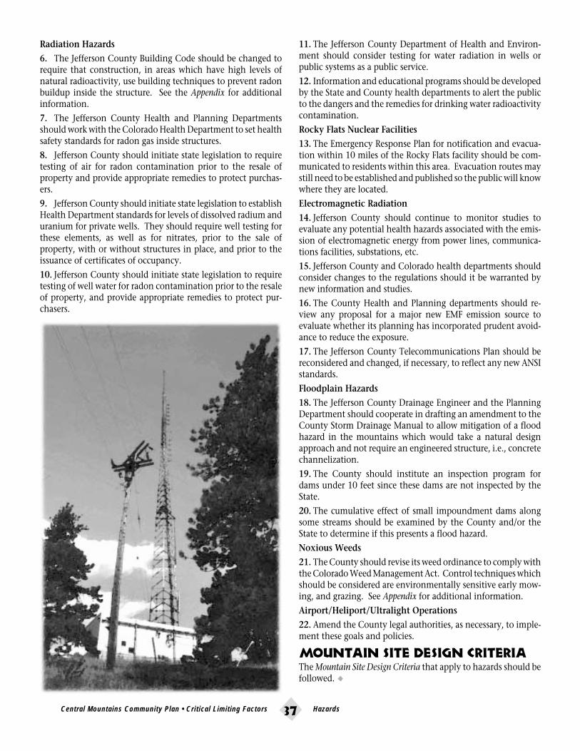
•37
Radiation Hazards
6. The Jefferson County Building Code should be changed torequire that construction, in areas which have high levels ofnatural radioactivity, use building techniques to prevent radonbuildup inside the structure. See the Appendix for additionalinformation.
7. The Jefferson County Health and Planning Departmentsshould work with the Colorado Health Department to set healthsafety standards for radon gas inside structures.
8. Jefferson County should initiate state legislation to requiretesting of air for radon contamination prior to the resale ofproperty and provide appropriate remedies to protect purchas-ers.
9. Jefferson County should initiate state legislation to establishHealth Department standards for levels of dissolved radium anduranium for private wells. They should require well testing forthese elements, as well as for nitrates, prior to the sale ofproperty, with or without structures in place, and prior to theissuance of certificates of occupancy.
10. Jefferson County should initiate state legislation to requiretesting of well water for radon contamination prior to the resaleof property, and provide appropriate remedies to protect pur-chasers.
11. The Jefferson County Department of Health and Environ-ment should consider testing for water radiation in wells orpublic systems as a public service.
12. Information and educational programs should be developedby the State and County health departments to alert the publicto the dangers and the remedies for drinking water radioactivitycontamination.
Rocky Flats Nuclear Facilities
13. The Emergency Response Plan for notification and evacua-tion within 10 miles of the Rocky Flats facility should be com-municated to residents within this area. Evacuation routes maystill need to be established and published so the public will knowwhere they are located.
Electromagnetic Radiation
14. Jefferson County should continue to monitor studies toevaluate any potential health hazards associated with the emis-sion of electromagnetic energy from power lines, communica-tions facilities, substations, etc.
15. Jefferson County and Colorado health departments shouldconsider changes to the regulations should it be warranted bynew information and studies.
16. The County Health and Planning departments should re-view any proposal for a major new EMF emission source toevaluate whether its planning has incorporated prudent avoid-ance to reduce the exposure.
17. The Jefferson County Telecommunications Plan should bereconsidered and changed, if necessary, to reflect any new ANSIstandards.
Floodplain Hazards
18. The Jefferson County Drainage Engineer and the PlanningDepartment should cooperate in drafting an amendment to theCounty Storm Drainage Manual to allow mitigation of a floodhazard in the mountains which would take a natural designapproach and not require an engineered structure, i.e., concretechannelization.
19. The County should institute an inspection program fordams under 10 feet since these dams are not inspected by theState.
20. The cumulative effect of small impoundment dams alongsome streams should be examined by the County and/or theState to determine if this presents a flood hazard.
Noxious Weeds
21. The County should revise its weed ordinance to comply withthe Colorado Weed Management Act. Control techniques whichshould be considered are environmentally sensitive early mow-ing, and grazing. See Appendix for additional information.
Airport/Heliport/Ultralight Operations
22. Amend the County legal authorities, as necessary, to imple-ment these goals and policies.
Mountain Site Design CriteriaThe Mountain Site Design Criteria that apply to hazards should befollowed. •
Central Mountains Community Plan • Critical Limiting Factors Hazards

•38
Public Services & FacilitiesThe quality of life in a community depends, in part, on the quality of the schools,
neighborhood facilities, emergency services and public utilities. At the same time, theCentral Mountains area has a unique mountain character that should be preserved.Therefore, these services should be compatible with this mountain environment and
should not be expected to duplicate the level of service found in urban areas. For thesereasons, the impact of land development on the quality of services should be managed
with care to ensure that the provision of public services is consistent, reliable andadequate for the development it serves, and appropriate for the Central Mountains area.
hese elements in the community should be consis-tent, reliable and adequate for growth allowed byother policies in the Plan. At the same time, theunique character of each subarea should be under-
stood and preserved. The levels of service provided should be inaccord with each area’s character. Service provision should notenable or mandate development beyond the levels dictatedelsewhere in the Plan.
Goals1. Ensure that adequate, consistent and reliable public servicesare provided to support the land use recommendations for theCentral Mountains area.
2. Construct community/service facilities appropriate in scaleand design for this mountain community.
3. Maximize shared use of community/service facilities.
4. Ensure that all areas in the Central Mountains area are servedby public fire protection providers.
5. Improve intergovernmental, interdistrict cooperation forfire, law enforcement, emergency/disaster, and school services.
6. Expand law enforcement in public land areas.
7. Avoid overcrowded schools.
8. Ensure that new development bears the equitable share ofthe increased demand for, and cost of, new public services.
PoliciesA. All Service Providers1. Adaptive reuse and shared use of existing structures andfacilities should be considered before new facilities are con-structed.
2. The scale and siting of new service facilities should beappropriate for this mountainous area, should include adequatebuffering, and should be in compliance with other policies inthis Plan and the Mountain Site Design Criteria.
3. Applicants are encouraged to involve community represen-tatives in the location and design of new and expanded servicefacilities.
B. Schools1. New development should bear the equitable cost of provid-
Public Services & Facilities Central Mountains Community Plan • Critical Limiting Factors

•39
ing major capital improvements and new school facilities thatwould be required because of the growth impact of new develop-ment.
2. If new development results in overcrowded schools, or the R-1 District standards cannot be maintained, land use solutionsshould be stressed. These solutions could include, but not belimited to:
a. Phase development of the project to pace the demand to theexpansion capabilities.
b. Adjust school fees to be paid by the land developer to betterapproximate the actual costs incurred by the addition of the newstudent population. Fees collected should be escrowed andexpended for capital improvements in the high school atten-dance area where the development is located.
3. Jefferson County R-1 Schools and Jefferson County shouldcontinue to monitor growth, the impacts of development pro-posals on school facilities, and seek alternatives to the over-crowding of schools, in accordance with school district policies,procedures and criteria. Referring development proposals to theR-1 School District for review and comment should be contin-ued.
4. Planning for school locations by R-1 should continue to bein compliance with school district policies, procedures andcriteria and other policies in this plan and the Mountain SiteDesign Criteria. The planning process should strive to achievethe following goals:
a. reduce commuting time and distance;
b. design facilities which provide for shared uses by the com-munity;
c. design facilities which are sensitive to the mountain envi-ronment; and
d. continue community involvement and input in decisionson school facility planning.
5. An effort should be made to provide clean feeder boundarieswhich will allow the elementary school students to continue tothe same junior/middle high schools and high schools.
C. Fire Protection1. All development, including all open space and parks in thecommunity, should be served by one public fire protectiondistrict.
2. Fire protection service for the community should be main-tained or improved as new development occurs. New develop-ment should pay for service in proportion to its needs whenthose needs exceed the capacity of the district, i.e., buildings,equipment and training.
3. New developments, including areas already platted, shouldbe required to provide an adequate onsite water supply for firefighting purposes, as required by the fire district of jurisdiction,prior to the issuance of a building permit.
4. Fire protection providers should review water and sanitationdistrict plans for water lines to ensure the adequacy of the fireflow for fire fighting, and should acquire and maintain allexisting and new fire hydrants.
5. Installation of sprinkler systems should be encouraged innew development, both residential and commercial. The dis-tricts and insurers should consider incentive programs for theinstallation of sprinkler systems. When sufficient water pressureis not present, then a modified sprinkler system which protectsexit paths should be considered.
6. Fire protection providers should continue to review develop-ment proposals and exemptions referred to them by the JeffersonCounty Planning Department prior to approval of new develop-ment and exemptions. This review should include an assess-ment of:
a. the adequacy of the proposed water supply and capability ofwater storage facilities to deliver the required fire flow for fireprotection;
b. the accessibility, external and internal, to the site for emer-gency vehicles, e.g., fire department access roads as required bythe Uniform Fire Code;
c. the capacity of the personnel and equipment to serve thesize and type of development proposed;
d. defensible space;
e. fuel breaks;
f. forest-wide thinning;
g. site-specific mitigation plans; and
h. “pre-attack” plans.
7. Street address or fire district numbers should be prominentlydisplayed near the road, preferably in three inch or larger nu-merals made of reflective material.
8. Prescribed burning should be encouraged on public andprivate open space. When necessary, the burning must complywith health regulations pertaining to air quality and fire regula-tions pertaining to public safety and welfare. All other burningshould be coordinated with the applicable fire district.
9. All public thoroughfares, access roads, and driveways shouldbe designed to meet fire district equipment access requirements.The County should continue to prioritize existing road improve-ments, considering safety and egress under emergency situa-tions.
10. County-wide mutual aid agreements should be encouragedand maintained by all adjacent fire protection districts.
11. Fire protection districts should continue to respond to haz-ardous material and waste incidents and to coordinate with theappropriate emergency agency.
12. Open Space and Denver Mountain Parks should instituteand enforce specific fire safety standards, e.g., no smoking orcampfires on Jefferson County Open Space, cooking and firesonly in firepits on Denver Mountain Parks. Areas should haveclear signs on what is prohibited.
D. Sheriff/Police and Emergencyand Disaster Services1. New growth in the community should not result in a dete-rioration of services provided by the Jefferson County Sheriff’sDepartment, but should bear the equitable cost of providingmajor capital improvements, facilities, and personnel that would
Central Mountains Community Plan • Critical Limiting Factors Public Services & Facilities

•40
be required because of the growth impact of new development.
2. A new Sheriff substation should be located in the area; apossible location is the northwest corner of Lookout MountainRoad and U.S. 40 next to the ambulance station.
3. Emergency service levels should be maintained and im-proved as new growth and development occurs and trafficdemand increases.
E. Utilities1. Adequate and timely utility services for existing and futuredevelopment should be provided.
2. Service lines for telephone, electricity, cable television, etc.,should be buried.
3. When overhead service lines must be installed, such linesshould be planned to blend with the natural landscape. Powerlines should follow contours when possible. Ridges should becrossed at the lowest point, e.g., along a drainage swale or saddle.Powerline rights-of-way in forested areas should be featheredthrough rather than clear cut. Powerline structures and linesshould be dark in color to recede into the landscape rather thanbe visually obtrusive.
4. Any change in telecommunication tower quantity or loca-tion should conform to the most recent County Telecommuni-cations Plan and policies.
5. Cellular facilities should be sited as per the Telecommunica-tion Plan.
F. Community Facilities1. The demand for community facilities, e.g., libraries andcommunity centers, increases as an area grows. When the needfor these facilities has been determined, the location should beselected in accord with the Community Plan recommendations.
2. Shared use of community facilities should be explored bycommunity organizations. This would minimize the need fornew structures.3. New facilities, including schools, should be designed tocomplement the mountain environment in scale, building ma-terials and architecture. New facilities must meet the require-ments of the Mountain Site Design Criteria, and/or school districtdesign and policy criteria.
Implementation1. Amend the County legal authorities, as necessary, to imple-ment these goals and policies.
2. A joint study should be initiated between the County and R-1 School District to investigate community needs such as alibrary, community center, post office, and similar facilities. Thestudy should include possible locations for such facilities if theyare deemed necessary, and if it is feasible to provide suchfacilities.3. The fire districts and private insurers should consider incen-tive programs for the installation of sprinkler systems.
4. Consolidation of fire districts or redistricting should beimplemented to maximize fire protection capabilities.
5. When Fire District boundaries are reviewed, adjacent devel-opment without fire protection should be considered for inclu-sion into the expanded district.
6. Publicly owned lands in mountain areas should contributefinancially to support the fire district of jurisdiction.
7. There should be increased cooperation and coordinationbetween the County Sheriff and the Denver Mountain Parkspolice to improve the quality of law enforcement in the parks.
8. Intergovernmental and interdistrict agreements on jointresponsibility for outlying areas should be adopted to ensurethat response time is as short as possible.
9. Area fire departments should make their standards andrequirements consistent. Area fire departments should unilater-ally adopt the Uniform Fire Code.
10. All fire cisterns should be filled and maintained and checkedprior to permits being issued.
11. Acquire funding for the design and construction of a floodwarning system for Bear Creek.
12. Acquire funding for the design of an evacuation plan, par-ticularly for wildfire emergencies.
13. Explore changing the Land Development Regulations to indi-cate that school fees are based on the assessed value of “devel-oped land” rather than raw land.
Mountain Site Design CriteriaAll of the Mountain Site Design Criteria should be considered inplanning and designing the facilities needed for public ser-vices.•
Public Services & Facilities Central Mountains Community Plan • Critical Limiting Factors

•41
Water & SanitationThe physical availability of water will be a key factor in the development of theCentral Mountains area. The health and safety of the community’s residentsand its environment depend on an adequate and safe supply of water. Proper
planning and maintenance of the quantity and quality of the water is essential.
and development affects both the supply of and de-mand for water within an area and must be managed.Some residents in the community are served by waterdistricts and water and sanitation districts. Some of
these districts rely on surface water (streams) for their supply,while others rely on wells. Other residents depend on individualwell and septic tank/leach field systems.
Improper treatment or disposal of effluent can result in groundwater and surface water contamination. Because of this correla-tion, the impacts of existing and future development on thissensitive resource should be studied and managed to ensure safeand adequate supplies of water.
Regulations on minimum lot sizes and the keeping of livestockare needed to protect the integrity of this resource. Restrictionsare necessary to protect the quality of both surface water andground water in areas with steep slopes, poor soil profiles and/ordrainageways, gullies, etc. The community’s groundwater sup-plies must be protected from significant depletion and contami-nation.
Goals1. Ensure that water resources are not depleted by balancingthe physical supply of water and water demand.
2. Maintain or improve water quality as new developmentoccurs.
3. Identify existing water contamination sources and mitigateor eliminate them.
4. Protect existing surface waters to maintain important eco-systems.
PoliciesA. Residential1. Lot sizes less than 10 acres should only be allowed if thefollowing requirements are met:
a. A public water and/or sanitation system is available; or
b. Where individual wells are to be used, lot sizes may bereduced to the minimum allowed by the County Health Depart-ment or 3.5 acres, whichever is larger, if the applicant canprovide both:
1) a satisfactory hydrologic study which includes:
a) a demonstration that there is an adequate water supply forthe needs of future residents; and
b) a demonstration that there will be no adverse impacts (suchas depletive effects or well-to-well interference) on neighboringwater users, or that any such adverse impacts will be adequatelymitigated. (This may include a court-approved plan for aug-mentation.)
2) an effective plan to protect water quality long-term, such as:
a) effective individual water treatment systems;
b) extra deep casing of wells;
c) clustering of individual sewage disposal system to maximizewell-to-leach field distance;
Central Mountains Community Plan • Critical Limiting Factors Water & Sanitation

•42
d) utilization of community wells;
e) maximization of the distance between wells and leach fields;and/orf) use of a community sewage treatment system.
2. For lots on individual wells, the overall (gross) density of aproject should be at least 5 ac/du.
3. The existing groundwater resource should be protected.New or existing development should not be allowed to depletethe existing groundwater supply beyond the ability of the localarea to adequately recharge itself.
4. When an area has been identified by the County or ColoradoDepartment of Health as having a groundwater problem, nozoning or health variances or changes should be approved thatwould aggravate the problem.
5. New public water and sanitation districts or public waterdistricts outside of community centers should be formed underthe following conditions:
a. Water quality or quantity problems exist that should bemitigated. The boundaries of the new district should encompassthe problem area, where practical and appropriate.
b. The new district will facilitate meeting the Mountain SiteDesign Criteria, e.g., the clustering of housing units whichmight be precluded if individual wells and septic systems werenecessary.
c. Where there is hydrologic evidence that neighboring waterusers or natural environments will not be adversely affected byexporting effluent out of the area, if local recharge is not pro-posed.
d. The planned level of development can be shown to beconsistent with the other policies of this Plan, especially theTransportation section.
6. New wells should not be allowed in a district where ground-water is the source of water because of the potential depletion ofgroundwater and the loss of water not recharged to the localarea.7. Where there is an existing public water and sanitation dis-trict or public water district, the housing densities recommendedin the Housing section of this Plan should be followed.
8. Whenever practical for the general public good, the consoli-dation of water and/or water and sanitation districts should beexamined and encouraged.
9. The County should not approve special water districts wherethe bylaws allow privately owned laterals.
10. Increased awareness of problems associated with specialdistricts has resulted in growing public concern about the eco-nomic viability of these districts. For this reason, the County isencouraged to evaluate these problems during service plan re-views and undertake appropriate action to secure legislationand/or regulations to better control the formation and opera-tion of special districts.
11. To create a more dependable water and sanitation or publicwater district, the water source should be one that is legally andphysically available. Two water sources are preferred as thesource of water for public systems.
12. In areas zoned or applying for zoning for livestock, themaximum number of large animals, including horses, buffalo,cows, sheep, llamas, goats, pigs, mules, donkeys or burros,should be assessed on a case-by-case basis. In no case will themaximum number of large animals exceed one per acre. Theassessment should be based on information from the propertyowner that demonstrates through technical, site-specific reportsthat the lot contains adequate natural conditions (e.g., soils,slopes, vegetation) to accommodate animals without adverselyaffecting ground or surface water, either on site or downstream,or causing accelerated soil erosion.
13. The County should investigate the benefit of licensing largeanimals as a means of better monitoring large animal impacts inthe mountains.
NOTE: See Housing, Transportation, Hazards, Visual Resources,and Wildlife sections.
B. Commercial1. Development within the community centers is intended tobe more dense. Community centers should be served by publicwater and sanitation systems.
2. To assure more coordinated planning and more efficientprovision of services, each community center should have asingle management authority that provides water and sanita-tion services, i.e., one public water and sanitation district versusthree or four districts.
Implementation1. Amend the County legal authorities, as necessary, to imple-ment these goals and policies.
2. The County should actively explore alternatives to the stan-dard soil absorption systems to treat sewage effluent.
3. The County should facilitate distribution of informationregarding water and sanitation problems so that they can beaddressed on an individual level.
4. The criteria for hydrologic studies as described in Policy #1and #6 should be developed by County staff to insure that studyinformation is adequate to evaluate whether plan objectives aremet.
5. The State should be encouraged to more strictly enforce theconditions placed on well permits and water augmentationplans.
6. A comprehensive study of groundwater quantity and qualityshould be completed by the State and County for as much of thestudy area as possible. The community should participate in thisstudy. It should include random investigation of septic systemsfor failure and random sampling of well water for fecal coliform,nitrate, and phosphorus contamination.
7. Once sources of contamination are identified, a programshould be established by the County to mitigate or eliminate thecontamination.
8. The County should conduct a detailed study to establishspecific recommendations on animal density and standards. •
Water & Sanitation Central Mountains Community Plan • Critical Limiting Factors

•43
efore Interstate 70 was built and before the area’s localroads were paved, Denverites flocked to LookoutMountain to escape the summer heat and the city.Vacation retreats were established, often a cabin on a
small parcel of land, with an outhouse in the woods. Prized fortheir privacy, big trees, cool breezes or grand views were CodyPark, Rilliet Park, Lookout Mountain Park and Panorama Estates.Idledale boasted a strong summer population drawn by thecottonwoods and cool waters of Bear Creek. Genesee Mountainlured campers and some small scale development. Portions ofthese areas were subdivided into very small lots that did notalways consider well and septic separation; practical, safe access;environmental protection; or the preservation of views fromadjacent lands.
As roads and cars improved, commuting to Denver becamefeasible, and people who had fallen in love with the mountainlifestyle began to winterize existing homes or build new ones onthe subdivision lots that had been created. Suddenly those areaspeople sought for their remoteness were now desirable for theiraccessibility.
Today, the appeal of “close in” mountain living, the majoramount of open space and parks which enhance the quality oflife for families, and the mountain and city views cherished byresidents all contribute to making the Central Mountains Area ahighly desirable place to live.
The dilemma facing this area involves these major issues:
• How can the desirable aspects of “mountain living” (e.g.,privacy, clean air and water, natural settings), be protected whileacknowledging current development pressures and propertyrights established many years ago?
• What can be done to mitigate the undesirable aspects thatarise when these (old time) land use rights designed for weekendand summer use (e.g., small lots, well and septic inadequacies,substandard roads) are converted to year-round, constant use?
• What can be done about the use of these small lots as theybecome more desirable for new development in the CentralMountains Area?
Many aspects of development addressed in other sections of thisplan must be considered when calculating appropriate residen-
Central Mountains Community Plan • Future Development Housing
FutureDevelopment
HousingThe history of residential development in the Central Mountainshelps explain both the diversity of housing types available and
the patterns of growth in the different neighborhoods.

•44
tial densities, locations, and site configuration. These includeWater & Sanitation, Wildlife, Hazards, and Visual Resources.
One of the leading negative impacts of development on steeplysloping property is the visual impact of hillside cuts and highprofile construction. To avoid this condition, developmentshould meet or exceed the minimum criteria established in theMountain Site Design Criteria.
The housing recommendations in this section are intended toaccommodate future housing needs in a way which is compat-ible with the unique resources of the Central Mountain Area.When development is proposed, the characteristics of the siteare identified and development impacts are evaluated. It isduring the development review process that wildlife and visu-ally sensitive areas are identified, the capacity of the roads tocarry additional traffic is determined, the water and sanitationconcerns are noted, and the availability of essential servicesidentified.
The other sections of this Plan and the Mountain Site DesignCriteria contain more definitive recommendations which shouldbe applied during the land development review process. How-ever, all density recommendations in this section are the resultof a synthesis of all of the other policies and objectives con-tained in the Plan.
Goals1. Provide for a diversity of housing opportunities consistentwith the unique resources and constraints of the Central Moun-tains area.
2. Maintain the mountain residential scale and character ofeach neighborhood within the study area.
3. Protect visually prominent features and steep, treeless slopesfrom disruption by development.
4. Encourage lower density residential development that isenhanced by open space.
5. Permit and accommodate well planned and well executeddevelopment, including small scale higher density housing.
6. Provide housing for people of different life styles and differ-ent levels of income.
7. Ensure that residential development is in balance with aproven source of appropriate, safe, and timely water and sanita-tion, public services, transportation, schools, preservation ofviews, etc.
8. Ensure that future residential development respects theunique mountain ecosystem and natural environment, andenhances the quality of life, particularly the “open” natureenjoyed by the residents, in the Central Mountains.
PoliciesA. General1. Rezonings should be processed as Planned Developmentuntil such time as revision of the County Zoning Resolution andthe Land Development Regulation to include design guidelines,site review process, etc., assures that a comparable or betterdevelopment outcome can be achieved under straight zonedistricts.
2. New residential development should complement the char-acter of the community, comply with the recommendations inother sections of this Plan, and comply with the applicableMountain Site Design Criteria.
3. Land that is zoned and platted, or is exempted from platting,should comply with this Plan’s recommendations and the Moun-tain Site Design Criteria at the time of building permit applica-tion.
4. All development should be adequately served by a fire pro-tection district with competent personnel who can serve andprotect. In areas where access is poor and the safety of residentsis compromised (i.e., Cody Park), then downzoning to limitadditional development could be an option.
5. Development should make maximum use of the site’s exist-ing vegetation to screen development. The appropriate recom-mendations in the Visual Resources section and the Mountain SiteDesign Criteria should be followed.
6. When resource areas (i.e., wildlife range, vi-sual resources, historical sites, etc.) overlap on asite, the resource evaluation should balance thecompeting values of these resources to achieve theintent of this Plan.
7. Much of the existing zoning does not con-form to these policies. To achieve long rangesolutions to inappropriate land uses that have notbeen built out, all existing plats and zonings thatdo not meet these policies should be brought intocompliance with the policies using methods suchas downzoning, open space acquisition, densitytransfers, conservation easements, tax incentives,etc.
B. Residential Densities1. Housing densities shown in this Section shouldnot be construed as guarantees of the number ofresidential units which may be built upon a site.The actual number of units is determined by apply-
Housing Central Mountains Community Plan • Future Development

•45
ing the recommendations in this and other sections of this Planand by the degree of compliance with the Mountain Site DesignCriteria.
2. In addition to the Mountain Site Design Criteria, the site’snatural features and slope must be considered. The density forthe site is determined by whichever factor is most restrictive.Excellence of design results from achieving the objectives andpolicies of the Mountain Site Design Criteria. In addition, thepolicies of the other applicable sections of this Plan (e.g., VisualResources; Open Space, Trails and Recreation; Hazards; Transporta-tion; Wildlife; and Water & Sanitation) must also be met.
3. Scenic corridors and slope.
Due to the sensitivity of scenic corridors, no additional develop-ment should occur within the corridors unless the developmentcan be screened. (See the Visual Resources section for relatedpolicies.) Provided that excellent design can be achieved inthese areas, the densities in the Excellent Design Densities tablewill apply.
4. Wildfire Hazards
Severe and moderate wildfire hazards should be mitigated tomoderate and low hazard levels as development occurs.
If mitigation does not occur, then the following densities shouldapply:
Unmitigated high hazard - no dwelling units
Unmitigated moderate hazard - 1 du/35 acres
5. Wildlife
No development should be allowed in critical wildlife areas.Densities otherwise allowed under other policies may be trans-ferred to another less sensitive portion of the site. The “criticalwildlife” designation should be based on the best availableinformation from the Colorado Division of Wildlife or consult-ant studies. The map within this Plan is intended as a generalguideline since wildlife areas change over time. The Mountain
Site Design Criteria and the Wildlife section should be reviewedfor additional information and guidance.
6. Geologic Hazards
No development should be allowed in Geologic Hazard OverlayZone districts unless adequate mitigation or elimination of thepotential hazard can be demonstrated. No transfer of densityshould be allowed from areas inside the Geologic Hazard Over-lay Zone District.
In geologic hazard areas which are identified during analysis ofa site, and which are not included in the Geological HazardOverlay zone district, the density may be transferred to anotherportion of a site.
7. Floodplain Hazards. (See Appendix for further information.)
In floodplain hazard areas shown on the Floodplain maps adoptedby the County, no credit for the transfer of density should begiven, and only development which meets the County Flood-plain Management regulations would be allowed.
(Recommendations above are based on the premise that theGeologic Hazard Overlay Zone and the Floodplain Maps adoptedby the County currently restrict development and therefore it isnot reasonable to give a development transfer credit.)
8. Transportation
Traffic generated by new development should not result in aLevel of Service below that recommended in the Transportationsection of this Plan.
9. Water & Sanitation
At rezoning, when lot sizes less than 10 acres are proposed, therecommendations in the Water & Sanitation section providealternatives which should be applied to ensure the adequacy ofindividual water and sanitation systems. The maximum resi-dential densities in areas without public water and sanitationshould be as follows:
With adequate hydrological studies and water quality protec-tion plan- 1 du/5 acres.
Without adequate hydrological studies and water quality pro-tection plan- 1 du/10 acres.
Individual lots may be as small as 3.5 acres provided the overall(gross) density of a project is at least 5 ac/du.
Implementation1. Amend the County legal authorities, as necessary, to imple-ment these goals and policies.
2. The Jefferson County Land Development Regulation should beamended to implement the policies of this plan.
3. The County should pursue state legislation that would allowcounties and municipalities to vacate obsolete plats. This wouldinclude plats that were recorded, but never approved by theCounty.
4. The County should investigate methods and/or provideincentives to bring existing substandard developments up toCounty standards, including roads, wells and septic systems.
Mountain Site Design CriteriaSee the Appendix for the Mountain Site Design Criteria. •
OutsideSlope ScenicCategory Corridor Inside of Scenic Corridor
Class I Class II Class III0-30% 1du/1 ac* 1 du/10 ac 1 du/2.5 ac* Same density30-40% 1 du/2.5 ac* 1 du/10 ac 1 du/2.5 ac* applies as40%+ 1 du/35 ac** 1 du/35 ac** 1 du/35 ac** Outside of
Scenic Corridor
* Must be served by a water and sanitation district. Where individual wells and septic systemsare to be used, the minimum lot size is that allowed by the County health department.
** Units can be transferred off 40%+ slopes at a credit of 1 du/20 ac to be built on the 0-40%slope portion of the site.
NOTE: All numbers above are for “excellent design”. Standard design is 1 du/10 ac for 0-40%slopes outside the scenic corridor and 1 du/35 ac for all areas above 40% and inside the sceniccorridor.
CLASS I areas are described as those with few or no trees (little screening potential, wetmeadows, or unique natural features.) These are typically south or west facing slopes withoccasional Ponderosa pine or Rocky Mountain juniper.
CLASS II areas are those with heavier tree cover, and are typified as usually north or eastfacing slopes with a medium to heavy density of Ponderosa pine, Blue spruce, and Douglas fir.
CLASS III areas are those that are included within the limits of the scenic corridor, but becauseof topographic conditions cannot be seen from the scenic corridor.
excellent design densities
Central Mountains Community Plan • Future Development Housing

•46
4. Previously disturbed areas should be enhanced through sen-sitive redevelopment, especially areas highly visible from theview corridors along I-70 and Bear Creek Canyon.
Policies1. There should be no additional commercial, office or indus-trial zoning in the Central Mountains Area with the followingexception:
- Commercial square footage in Idledale could target localresidents or tourists. This area may be especially appropriate forsmall scale craft and antique type shops or restaurants. Propos-als should incorporate architectural detailing appropriate to theCanyon setting, and should orient toward Bear Creek wherepossible, to encourage pedestrian use.
2. Commercial activities should be tailored for the conve-nience of local residents and to provide limited employmentopportunities.
3. Locate commercial land uses in neighborhood centers toavoid strip development along roads.
4. Improve the appearance of existing commercial and publicsites through landscaping, painting and regular maintenance.All lighting should be downcast and not be allowed to reflectoffsite.
Commercial & Office DevelopmentThe Central Mountains area has limited and restricted
services in the immediate area. Residents and workers haveminimal access to shopping and services. The area providessome local employment opportunities, however the majority
of the residents work in the metropolitan region.
arge commercial areas are either planned or built bothwest of this area at El Rancho and east along I-70, C-470, 6th Avenue and Colfax Avenue. Access to goodsand services in these areas reduces the need to substan-
tially increase retail and office zoning in the area. Buildout ofthe existing commercial zoning will provide sufficient goodsand services to serve the daily needs of the residents.
Currently, a number of parcels along County Road 73 are zonedfor commercial purposes in the Idledale area. Given the existingcommercial zoning, it may be appropriate to consider highquality retail or mixed use proposals in this area in the future.Character and scale are key issues to be addressed when consid-ering any commercial proposal to ensure compatibility with thelocal mountain environment.
Goals1. The area’s primarily residential and open space charactershould be maintained.
2. Ensure that commercial activities are compatible with sur-rounding land uses in terms of visual appearance, traffic genera-tion, water and sewer requirements, noise and air quality im-pacts.
3. Existing commercially zoned areas in neighborhood centersshould be enhanced by upgrading the design specifications toconform to the mountain character.
Commercial & Office Development Central Mountains Community Plan • Future Development

•47
Neighborhood CentersThe neighborhood centers proposed for the Central MountainsArea are intended to recognize where existing commercial devel-opment occurs or could occur and to minimize the pressure forstrip development along the road. These centers provide someaccess to goods and services needed by local residents andshould remain either convenience or neighborhood centers insize. They should be sited and designed to be compatible withthe surrounding area and at a scale that fits the character of thearea. These centers should be consistent and compatible withthe entrances to the residential areas.
Benefits to residents would include fewer miles driven to pur-chase goods, get to work, and take children to athletic activities,music lessons, etc. This reduction in miles driven would con-tribute to better air quality in the mountains and the metropoli-tan region, and lower transportation costs and the demand forexpanded roads.
The centers are not intended to provide the major employmentopportunities nor to duplicate the diversity of goods and ser-vices found in the commercial areas which exist in the metro-politan area.
Designated neighborhood centers are:
• U.S. 40 and Lookout Mountain Road• Lookout Mountain Road in the vicinity of Buffalo Bill’sGrave
• Genesee Business Center• Downtown Idledale• The commercial area at I-70 and the Morrison Road exit
A. Specific Policies1. Preservation of existing vegetation for screening and erosioncontrol should be a priority in site plan development.
2. Safety should be a primary concern when access drives toneighborhood centers are developed.
3. Neighborhood centers should be designed to serve the dailyneeds of residents and tourists.
4. All nonresidential development and redevelopment shouldcomply with the Mountain Site Design Criteria.
5. Retail, office and limited compatible service activities shouldbe located inside designated neighborhood centers. The usesconsidered appropriate for the neighborhood centers are:
a. Mixed use convenience centers where goods and servicesand employment opportunities are available to the residents ofthe area;
b. Artist studios, craft shops, gift shops, etc.;
c. General stores, small retail shops, small scale offices, andrestaurants;
d. Community facilities, e.g., community/senior centers,daycare centers, library, post office, schools and emergencyfacilities.
6. Although often permissible by the underlying C-1 Zoning,new uses of the following types are generally considered incom-patible and undesirable by the residents of this area and shouldnot be allowed:
a. Gas stations, service stations, car wash and auto repair facili-ties;
b. Rental stores, arcades, pool halls, night clubs, etc. ;
c. Fast food or drive-in restaurants.
7. New rezonings should allow only those commercial useswhich can be supported by a public water and sanitation districtor a public water district.
8. Structures should be designed to blend with the existingterrain, i.e., should avoid expanses of unbroken walls and shouldhave an architectural finish compatible with the rural mountainsetting.
9. Any expansion of the centers should provide for safe access,landscaping and overall improvement to the visual appearance.
10. A minimum of 25% open space should be provided.
11. The neighborhood center at I-70 and the Morrison Road exitshould be redeveloped to better accommodate the tourist trade.A tourist information center and similar tourist related uses areappropriate due to its location at the main entrance to themountains.
Outside Neighborhood CentersA. Specific Policies1. Home occupations under the current County Zoning Reso-lution are allowed for a limited range of businesses such asprofessional services, consulting, tutoring, craft work, smallrepair services, and art studios. While the County does notenforce covenants which may limit or prohibit home occupa-tions, residents are advised to review applicable covenants priorto applying for home occupation status. This Plan endorses acontinuation of the home occupation regulations, with amend-ments that will accomplish the following objectives.
a. Require that the residence used for the home occupation isthe principal residence of the applicant, not a secondary one.
b. Provide adequate off-street parking.
c. Impose limitations on home occupations allowed on verysmall residential lots more strictly than on larger lots which canbetter absorb impacts.
d. The use, storage, or production of any hazardous materials,substances, by-products, residue, or wastes should be prohib-ited.
e. Prohibit adverse effects from noise, odors, smoke, glare, orvibration beyond that associated with adjacent uses.
f. No outside storage of materials or vehicles.
2. Churches, schools, bed and breakfasts, and group homes.
a. These uses should be allowed when:
1) the architectural quality and size of the building(s), thepercent of site coverage, and traffic impacts are similar to thoseof surrounding land uses;
2) off-road parking is provided and screened from adjacentproperties;
3) conformance with the appropriate Mountain Site Design Cri-teria is demonstrated.
Central Mountains Community Plan • Future Development Commercial & Office Development

•48
3. No additional commercial development should be allowedon the two commercially zoned properties located outside of theneighborhood centers (just east of Apex Park and along ClearCreek at State Highway 93). These two areas should be downzoneddue to lack of access, steep slopes, flooding concerns, etc.
4. Expansion of visually obtrusive developments outside ofneighborhood centers such as the County Shops on U.S. 40should not be allowed.
5. To encourage enhancement of the mined site at U.S. 40 andParadise Hills Road, it could be considered for development assmall scale community service uses. Uses considered to beappropriate would be community facilities, e.g., community/senior centers, daycare centers, library, post office, and emer-gency facilities. If developed it should utilize design sensitive tothis highly visible location (which serves as the entrance to thecommunity) and compatible with the mountain character.Planned uses should target local residents to limit traffic conges-tion.
Implementation1. Amend the County legal authorities, as necessary, to imple-ment these goals and policies.
2. The County should do Action Plans for these neighborhoodcenters and include, as a minimum, representatives from the
community, existing businesses, property owners, the JeffersonCounty Public Works Division, Health Department, PlanningDepartment, Open Space Department and Regional Transporta-tion District. The purpose of these plans should be to draftconceptual designs for the redevelopment of these centers.
3. The objectives for Action Plans should be to:
a. improve the quality and extent of services and physicalappearance;
b. improve landscaping and visual impact mitigation;
c. improve traffic access and parking capacity;
d. establish criteria for structures which would blend with theexisting terrain, i.e., the structures should avoid expanses ofunbroken walls and should have an architectural finish compat-ible with the rural mountain setting;
e. provide pedestrian access;
f. establish setbacks from the roads for structures;
g. establish techniques which make maximum use of the to-pography and existing vegetation to provide screening; and
h. increase the economic viability of the centers.
4. The Action Plans should include the following:
a. Access and parking plans for the centers.
b. Landscape plans for the centers which identify the mitiga-tion measures necessary to reclaim any mountainscarring and unrevegetated areas.
c. Designs for parks and other public communityfacilities, where appropriate.
d. Designated Park ‘n’ Ride location for ride shar-ing and RTD buses, with shelters, telephones andseats.
e. The funding source(s) required to implementthe Action Plans recommendations. Techniqueswhich could be used include creation of specialoverlay zone or improvement districts, public/pri-vate joint ventures, grants, and awards.
f.An implementation schedule which establishescompletion dates and assigns responsibilities foreach action.
5. The Action Plan Group should be responsiblefor presenting the Action Plans to the public forreview and comment, and to the Jefferson CountyPlanning Commission for adoption.
6. The County should initiate a downzoning ofthe C-1 parcel north of Apex Park due to its lack ofaccess, extreme slopes, and visibility from a longdistance.
7. The County should initiate a downzoning ofthe C-1 parcel located off of Clear Creek just west ofState Highway 93 due to its location in the flood-plain and poor access to State Highway 93.
8. The County Shops on U.S. 40 should be painteda receding color and screened to make them lessvisible from I-70 and the surrounding neighbor-hood. •
Commercial & Office Development Central Mountains Community Plan • Future Development

•49
hile the existing limited road network in the Cen-tral Mountains area serves the present needs ofresidents and commuters, traffic from future devel-opment, including build-out of existing zoning on
some segments, could exceed acceptable levels of service on theroads. Without proper planning, the topography of the areacould significantly constrain expansion of existing roads. Inaddition, the financial cost could be prohibitive and the visualimpact unacceptable to the community.
A limited feeder road network funnels area residents onto I-70,U.S. 40 and State Highway 74. Additional traffic generated byfuture development could confront the county and the commu-nity with hard choices:
1. Expand local roads, which could be an expensive and visu-ally impactive option. This would be difficult, especially onState Highway 74, given the narrow canyon, steep cliffs andadjacent creeks.
2. Accept a lower service level and increased travel times.
3. Provide alternatives, e.g., ride-share programs and publicand/or private transportation services.
4. Make safety improvements, e.g., climbing lanes, shoulderimprovements, etc.
5. Accept a lower density than allowed under current zoning.
While these choices are not imminent, they could occur in thecoming years as existing zoning builds out, if proper planning is
TransportationMaintaining the mountain community character of the Central
Mountains area is a primary concern of residents. This concern isfollowed closely by the desire to achieve state designation of I-70,
U.S. 6, State Highway 74, and County Road 93 as scenic corridors.
not done. The competing needs of local residents and travelersthrough the community should be resolved in a way thatpreserves the visual amenities and the open lands character ofthe mountain community.
Goals1. Safeguard scenic corridors and the mountain communitycharacter.
2. Designate I-70, U.S. 6, State Highway 74 and State Highway93 as scenic and historic corridors.
3. This system should provide local road links that foster asense of community.
4. Provide the transportation facilities needed for safe travel,including upgrading of existing facilities to provide a safe trans-portation system that satisfies the demands of local residentsand travelers through the community.
5. Reduce air pollution attributable to road surface and mainte-nance.
6. Adopt a schedule of improvements and identify the fundingsources to ensure that needed infrastructure is available tosupport future development and to assure that the transporta-tion system keeps pace with development in the area.
7. Coordinate planning and design of road improvements withthe community, developers, special districts, and appropriateagencies.
Central Mountains Community Plan • Future Development Transportation

•50
8. Develop programs and incentives to increase opportunitiesfor ride sharing and variable work hours.
9. Promote alternative modes of travel through education, andby providing mass transportation services which are reliable andconvenient to use, e.g., Park ‘n’ Rides.
10. Encourage facilities that would support alternatives to single-occupancy-vehicle travel, i.e., pedestrian, equestrian and bicyclepaths.
Policies1. Transportation improvements should be made in ways thatare sensitive to the community and protect the visual amenitiesalong the roadway corridors.
2. High traffic generators, i.e., higher density housing, retailand office land use, should be located on ornear mountain arterial and collector roads.
3. Road improvements should be madeonly when they can be done in a way thatis safe, functional and sensitive to theexisting natural environment.
4. Vegetation along roads and in mediansshould be provided. Native and naturalizedspecies which are drought-tolerant shouldbe used.
5. Level of Service C (LOS C) should be thestandard for Central Mountains Area roads,with LOS D acceptable during peak hours. WhenLOS D expands into nonpeak hours, roadimprovements which can extend the capac-ity of the roads should be considered for thecommunity, with a program for funding andtimetables established to prevent further declinein levels of service.
Given these system constraints, the Plan fully recognizes thatduring certain times of the day, a lower LOS may occur oncertain area road segments, which will result in more congestedroadways. Some additional congestion is preferred over majorroadway widening.
6. New zoning within the planning area should not be ap-proved when the traffic generated would result in LOS D orlower on existing road segments within the Central MountainsArea. An exception should be allowed when prior agreementsexist that commit public, private or combined public and pri-vate money to fund future road improvements which wouldresult in acceptable levels of service, would satisfy environmen-tal concerns and would be constructed within 5 years.
NOTE: A description of Levels of Service (LOS) appears in theAppendix.
7. The County should establish a procedure which would facili-tate the sharing of responsibility for providing improvements,necessitated by their developments, in proportion to the trafficimpacts of their project on the community’s road system. Re-quiring road improvements or assessing an equitable impact feeare two techniques which could be used.
8. Development should be phased when the traffic generated
by a proposed development will have the following impacts:
• Degrade the level of service below the acceptable LOS Dduring peak periods on the roads in the community.
• Exceed road conditions and the County’s maintenance ca-pability.
• Use roads that cannot be improved to meet traffic demandssafely because of physical constraints and that would haveadverse visual and community character impacts. Prior to thedecision of new development, the phasing should address theissue of equitable use of road capacity by existing and zonedland uses.
9. The County should continue to consider road capacity andtransportation standards when making land use decisions, andshould apply density or phasing restrictions equitably to devel-
opments when the traffic generationwould result in a level of service lowerthan LOS D on the road network.
10. County roads should be limitedto two through lanes with appropriate
turning, acceleration and deceleration lanes,climbing lanes and other safety improve-
ments.
11. New subdivisions should meet allCounty regulations for radii, grade,drainage, current lane widths, etc.
12. As part of new developmentsor at County initiative, road im-provements should be made to re-
duce accidents and to eliminate ex-isting hazards. These safety improve-
ments should include, but not be lim-ited to, the following examples:
• Traffic signals, turning lights
• Passing lanes
• Paving
• Shoulder upgrading
• Realigning of intersections
• Removing line-of-sight obstacles
• Straightening where major new cuts can be avoided
• Installing guard rails
• Constructing acceleration and deceleration lanes
• Turning lanes
• Providing multiple use paths for nonmotorized travel
• Pedestrian crosswalks
• Living snow fences
• Drainage ditch modification
Specific roads and intersections which should be improvedinclude:
Grapevine Road: This is used as a two-way road, and the lanewidths are inadequate for the traffic. This problem is exacer-bated by deep ditches and cars parked along the road. This road
Transportation Central Mountains Community Plan • Future Development
New zoning within the planning area should not be approved when the traffic generated would result in LOS D or lower on existing road segments within the Central Mountains area.

•51
is unsafe now, and future development would require upgradingwhich might result in condemnation of buildings built at theedge of the road. Improvement of Grapevine Rd. within Idledaleneeds to be very sensitively handled.
Pine Road: This is the only access into Cody Park. The road is toonarrow and too easily blocked, especially during winter months.A second access road into this subdivision should be explored toprotect the safety of the Cody Park residents. The number ofresidences presently exceed the number allowed under currentcul-de-sac requirements. If a second access cannot be created, areduction in density permitted should be explored. Refer to theHousing section for recommendations to downzone this subdivi-sion.
Lookout Mountain Road near Larkspur Drive: The curve is unsafe,and excessive amounts of gravel contribute to accidents at thislocation. Snow and ice on the road further increases the dangerhere.
Charros Road and Decker Drive: These roads should be studied todetermine what improvements can be made to reduce accidentson them.
13. All dirt roads carrying 150 ADT or more should be paved tomeet the EPA standards for dust pollution, or environmentallysensitive dust suppressants should be considered by JeffersonCounty Public Works.
NOTE: See additional recommendations in the Air, Odor & Noisesection of this Plan.
14. Increased cooperation among the park and recreation dis-tricts, Jefferson County Open Space and Highways and Trans-portation Departments, the Colorado State Highway Depart-ment and the Golden and Morrison Public Works Departmentsshould be pursued to ensure that the multiple use paths canbecome dedicated right-of-ways under the jurisdiction of one ofthe aforementioned entities.
15. Road improvements and right-of-way dedications by devel-opers should include sufficient width to accommodate multipleuse paths where excessive hillside cuts would not result. Main-tenance and liability coverage agreements for these paths shouldbe secured. (See Visual Resources section regarding road cuts.)
16. Public transportation should be encouraged as a viable alter-native to private vehicle travel. It can reduce the number ofvehicles using the roads and, in effect, extend the capacity of theroads for a longer period of time, as well as reduce the amount ofair pollution. For these reasons, the following actions should betaken:
a. Public transit service should be expanded to serve the travelneeds of the community’s residents.
b. Additional Park ‘n’ Ride sites should be provided as demandincreases.
c. Commuter rapid transit should be provided when the rider-ship demand exists, and feeder bus routes should be establishedto serve rapid transit stations.
17. The County should support transportation alternatives toreduce the impact of commuter travel which include, but are notlimited to, the following:
a. Flexible work days and variable work hours to extend thepeak travel hours;
b. Increased use of car and van pools; and
c. Multiple purpose paths which connect residential areas withlocal neighborhood centers and community facilities.
18. Developers should bear a proportionate responsibility forproviding improvements, both on and off site, needed to accom-modate the traffic generated by new projects, e.g., turning andacceleration/deceleration lanes.
19. Monies generated for road improvements to mitigate thetraffic impacts associated with new development in the CentralMountains Area should be earmarked for road improvementswithin the Central Mountains Area.
Implementation1. Amend the County legal authorities, as necessary, to imple-ment these goals and policies.
2. The County and the community should actively participatein the Regional Transportation District’s planning programs andlobby to upgrade public transit service as demand increases.
3. The Land Development Regulation should be amended tocreate new construction standards for mountain roads which aremore sensitive to the environment and are safe and functional.Private roads within developments should be allowed to developbelow County standards, provided Jefferson County Public WorksDepartment’s and fire district’s objectives for access, mainte-nance and safety can be met.
4. The County should try to acquire the necessary right-of-wayon heavily traveled roads which are not maintained because ofthe lack of right-of-way.
5. Where private roads are maintained by the County throughprescriptive right, the County should work with the owner toclarify the survey and legal description, then reduce the propertytax obligation on the portion of the property used as a publicroad.
6. The County should reevaluate its salt and sanding programto minimize the damage to trees and other forms of vegetationcaused by the salt and to minimize the fugitive dust air pollutioncaused by the sand.
7. The County should schedule road paving for dirt roadscarrying 150 ADT or more to reduce air pollution, explorecooperative paving agreements with residents, and considerapplying environmentally sensitive dust suppressants.
8. The County’s Lookout Mountain maintenance facility shouldbe substantially landscaped on all sides and painted a darkercolor to minimize its visual impact. The community should beinvolved in planning for improvements to this site.
9. Existing and new road placement standards should be imple-mented by the County to reduce the visual impact associatedwith road cuts in mountain areas.
NOTE: See Visual Resources and Housing section for more infor-mation.
10. The State should designate I-70, U.S. 6, State Highway 74 andCounty Road 93 as scenic and historic corridors, and establish a
Central Mountains Community Plan • Future Development Transportation

•52
fund to buy the slopes along the road and maintain them innative vegetation, e.g., Colorado wild flowers and native grasses.
11. The amount and rate of growth, travel patterns, and modesshould be monitored to determine what changes are occurringand whether recommendations on road size constraints need tobe reconsidered. Monitoring should continually evaluate theLOS.
12. The state should continue to monitor and enforce safetyprograms and laws to improve safety on I-70, especially at “DeadMan’s Curve”.
13. Sand should be removed from roads as quickly as possible toreduce vehicle damage, air pollution, vegetation damage, and toimprove safety and aesthetics. Further, the County shouldreduce the amount of salt being used on the roads for snowremoval.
14. A comprehensive transportation study should be done forthe Central Mountains Area of Jefferson County, which wouldidentify specific transportation improvements and funding ar-rangements which may be necessary to accommodate the traveldemands generated by the land use proposed.
This study should be a cooperative effort of the municipalities,communities, state and Jefferson County and should considerthe principal transportation facilities in the incorporated andunincorporated areas.
Examples of the strategies to be considered are:
• Expanded public transit service and facilities
• Expanded lanes
• Pedestrian, bicycle, equestrian paths
Upon completion of this transportation study, the Central Moun-tains Plan should be reviewed to determine the compatibility ofthe two documents and any inconsistencies resolved.
15. The Central Mountains Area community, Jefferson CountyR-1 Schools, RTD, fire districts, and state, federal and localtransportation providers should be included in the planningand implementation of transportation improvements from thebeginning of the process.
16. The County, the state and the cities are encouraged tocoordinate their work to achieve consistency of road surfaces,paved and unpaved, on roads that cross jurisdictional bound-aries, and to develop compatible design standards, e.g., right-of-way widths.
17. Coordination among the County, the cities, the communi-ties and public transportation providers should be instituted toplan and provide transportation improvements. This processwould help to avoid the adverse impacts of increased traffic fromnew development on the road system in the neighboring com-munities and the Central Mountains Area, and to resolve trans-portation concerns raised by annexations and roads which crossjurisdictional boundaries.
18. Public telephones and increased security should be providedat Park ‘n’ Ride sites. When planned, restrooms should beconsidered for the new tourist-related facilities at the MorrisonRoad/I-70 intersection.
19. Signage implementation as follows:
• I-70 at Exit 256: The stop signs at this intersection areconfusing and should be changed.
• Open Space Signs on Charros Drive: These signs should beremoved from Charros Drive. Traffic to the park should useSouth Lookout Mountain Road, which is a safer facility andwould reduce travel through the residential area along CharrosDrive.
• Apex Park: The “no parking” sign discourages the use of thepark.
• I-70 and Morrison Exit: Better directional signs are neededat this location.
Signage within the Central Mountains should be consolidatedto avoid confusion and visual clutter. Sign colors should bestandardized and designed to be compatible with the surround-ing environment. Back sides of signs should be painted orconstructed with earth tone colors or materials.
20. Parking implementation as follows:
• Buffalo Overlook/I-70 Exit 254: This tourist attractionneeds adequate parking because cars parked in the road andpeople crossing the road create a dangerous situation.
• Lariat Loop Road and Beaver Brook Trailhead: Additionalparking should be considered at this location because of theincreased use of the trail. Overflow parking creates a traffichazard.
21. A financial analysis should be completed to determine ifadditional road monies are required to augment federal, stateand county road funds. Such a financing program shouldinclude a consideration of impact fees, property taxes, improve-ment districts, and sales taxes to spread the cost of maintenanceand improvements equitably among existing and future users.Large and small developers should pay their fair share. Therecurring problem of developers claiming hardship and beingreleased from road obligations should be investigated, and pro-cedural changes should be made as necessary.
22. In addition to the above criteria, the construction of anypublic or private roadway should strive to achieve the highestdegree of sensitivity and compliance with Section 11: GradingPermit and Erosion and Sediment Control in the Zoning Resolu-tion.
a. Retaining walls are allowed at a maximum height of 6 feet.Maximum distance of any smooth surface wall (i.e., concrete)should be 50 feet. See the County’s Design Guidelines forspecifications for color and texture on walls.
b. Rock cuts* are allowed if rock staining occurs which comple-ments the natural surrounding landscape. Rock cuts should bevertical.
c. Encourage more restrictive regulations within the Gradingand Erosion Control regulations.
* Rock cut is defined as an excavation in competent bedrock. •
Transportation Central Mountains Community Plan • Future Development
•53
the physical and psychological well-being of the residents andare a major part of the quality of life in the County. Theycontribute to the County’s economy by providing and enhanc-ing recreational activities, such as hunting, fishing, camping,hiking, etc. They are valuable indicators of environmentalquality because they are sensitive to change, especially environ-mental deterioration.
The relationship between vegetation, animals, and human ac-tivities needs to be respected and consciously protected. Duringthe initial development, site preparation and construction stagesof projects, the potential for adverse impact on plants andchanges in unique plant-life and wildlife patterns are most likelyto occur. The adverse impacts are often far-reaching and com-plex.
The varying characteristics of individual sites will determinewhich of the following criteria may be applicable. In some cases,all of the criteria may be applicable, while in others, only somemay apply. All “bold print” criteria in the Design Criteria shouldbe applied to all site design.
I. Key ElementsA. Views1. Maximize views of significant features on and off site asamenities of site design.
2. Sensitive placement of structures should be an importantelement of site design to avoid obscuring significant publicviews.
B. Treeless Areas1. Naturally occurring wet meadows are scarce and shouldnot be disturbed.
2. In areas where very little natural buffering occurs, e.g.,treeless clearings, place site development into the vegetationalong the edge of the open area. Encroachment into open areasor clearings at the edges may occur only if additional features areprovided, i.e., vegetation which enhances the existing buffering.
C. RidgelinesBuildings or other structures should be located to avoid adominant silhouette on the top of the ridge. The ridgelinesilhouette should be composed predominantly of trees andlandforms. (Inside Visual Resource Map areas, this criterionshould be applied as an essential element in the achievementof excellent project design.)
Mountain SiteDesign Criteria
ousing densities allowed under the slope categories(see the Housing section) should not be interpreted asguarantees. Once the Policy recommendations inthis Plan have been met, the densities provided
under “Standard Design” can be achieved. Additional units, upto the maximum shown, can be earned through compliancewith the Mountain Site Design Criteria.
To achieve excellent project design, the criterion which apply toa site will be evaluated on two levels.
Criteria shown in bold and italicized print are essential to theachievement of excellent project design in the mountains. Cri-teria in regular type can be applied with a greater degree offlexibility when tradeoffs among conflicting design values arenecessary.
ObjectiveThe purpose of these criteria is to assist and encourage landown-ers and their designers in creating high quality developmentwhich respects the environment and to encourage creative andflexible approaches to site design. By using the criteria listedbelow, it is anticipated that more sensitive development willoccur. Developers who comply with these criteria should beawarded increased density. The density gained under excellentdesign can range from the number of units allowed for standarddesign up to the maximum number of units under excellentdesign, depending upon the degree of excellence achieved.
The dramatic beauty of the surrounding natural landscape is amajor asset in the mountains. Scenic or high quality elements ofthe natural landscape need to be maintained or enhanced, whileunattractive areas should be rehabilitated or enhanced. Alldevelopment should be integrated, through location and de-sign, with the existing natural character.
Visual quality of an area is the impression created by the land-forms, vegetation, color, adjacent scenery, scarcity or unique-ness, and cultural modifications within the view of a site.Generally, the more visual variety in a landscape, the moreaesthetically pleasing. Variety without harmony, however, isunattractive, particularly in terms of alterations (cultural modi-fications) made without care.
The views seen from major transportation corridors can have agreat impact in the mountain areas. The large numbers ofviewers make these corridors very important in establishing apositive image to visitors and residents alike.
Wildlife and unique vegetation are aesthetic, economic andenvironmental assets to Jefferson County. They contribute to
Central Mountains Community Plan Mountain Site Design Criteria

•54
D. Site Features1. Maintain site features in their natural state or enhance allsignificant features on a site:
a. Maintain and/or enhance streams and wetlands.
b. Maintain and/or enhance other significant features, e.g.,ponds, major rock outcroppings and unique vegetation.
II. Site ImprovementsMan-made features should not be the dominant features in thelandscape, but should blend with the surrounding environ-ment. Cultural modifications should be integrated into thelandscape to minimize visual scars and erosion and to createan impression that the new use “belongs” on the site.
A. Site Planning - GeneralThe terrain is richly varied, with flat sites being the exceptionrather than the rule. Each structure must be placed with criticalreference to natural topography. On sloping sites, all founda-tion and retaining walls will intersect natural grade with noobvious fill line. No cuts and fills will be left exposed to view.Extensive use of retaining walls will be used to integrate struc-ture and site. Cantilevered construction can be utilized toadvantage on sloping sites. Areas below cantilevers must befully finished and suitably landscaped with shade-preferringplant materials. Retaining walls will generally be of the samematerials used in adjacent structures except when using naturalsystems, such as boulder groupings.
B. Buffering Development1. Soften or interrupt views from off site to developed areas onsite, e.g., buildings, parking areas, roads, by the use of landforms,rocks, or vegetation.
C. Transition Between Uses1. Between two adjacent areas of different uses, provide abuffer, such as increased setbacks, vegetation, etc., betweenincompatible uses, if appropriate.
2. Where two projects of the same use abut, use similar densityor intensity at the common edges or other mitigating tech-niques.
D. Landscaping/Open Space1. Landscape projects sufficiently to enhance the aestheticsand functional qualities of the site and project.
2. Maximize the use of existing vegetation and natural land-forms wherever possible.
3. Introduced landscaping should consist primarily of native ornaturalized materials, placed in groups that emulate the naturalenvironment. Select and group plants to minimize consump-tion of irrigation water.
E. Grading and Erosion Control1. Design site development to minimize disturbances (cut,fill, tree clearing) caused by the introduction of roads, build-ings, and other structures.
2. Revegetate or enhance all earth disturbances regardless ofmagnitude (e.g., road cuts, building cuts, graded areas) withstaining and/or planting with native or naturalized materialswithin one growing season.
3. Roll regraded slopes back into the surrounding topographyto a grade that, when revegetated, will be stable and looknatural.
4. Retain drainageways and storm water detention areas intheir natural state, or emulate the natural environment, when-ever possible.
5. Refer to Section 11: Grading Permit and Erosion andSediment Control of the Zoning Resolution for more specificdesign standards.
III.Structure Design andPlacementThe relationship between structures and the surrounding land-scape is extremely important. This relationship can be definedin terms of scale, form, massing, orientation, and materials.
The perceived mass of structures and their overall form shouldconvey a small town/village image that provides visual varietyand a welcome to the passers-by.
Building materials should reflect the character and image of thecommunity as well, emphasizing natural looking materials.
The placement of structures should not be dictated by roadsand parking, which can create a “strip” development pattern,but by landforms and vegetation, views, and implementationof the village concept.
Historic sites and structures should be protected and preserved.Development around such sites should adhere to the characterof the historic element.
Roofs and other architectural components should blend withthe landscape.
Service and accessory uses are often afterthoughts in a project.Because these elements are especially important to pedestrianviews, they need similar architectural treatment to the primarystructure.
A. Building Orientation1. Orient buildings for maximum solar exposure and to capital-ize on primary views.
2. Group and design buildings to ensure privacy among units.
B. Architecture/Scale/Massing1. Design and site buildings to:
a. Be in proportion to the size of the lot, to the surroundinglandform and vegetation, to existing buildings and to theintended user, rather than appearing monumental in scale.
b. Be placed sensitively within a site, rather than to dominateor overpower a site. Integrate buildings into the site throughthe use of landscaping, earthwork, or natural materials.
c. Utilize an architectural design emphasizing natural mate-rials, light, shadow, depth, and texture in all exterior buildingsurfaces. Vary facades and roofs to minimize large expanses offlat planes.
d. Minimize exposed building foundations. Screen all me-chanical equipment including rooftop, with materials similarto or compatible with the building facade.
Mountain Site Design Criteria Central Mountains Community Plan

•55
e. Within a project, incorporate a unified scheme for build-ings, design, style, and complimentary materials.
f. Work with the topography, vegetation and views.
C. Historical Recognition1. New development should complement the historical andunique character of the area. Design new development toharmonize with and complement the character of the area inmass, scale, design and materials.
IV. InfrastructureImprovementsInfrastructure improvements should not detract from the care-ful planning efforts taken elsewhere on the site for the primaryuses.
A. Utilities1. Service lines for telephone, electricity, cable television, etc.,should be buried. Overhead lines should not be permitted inareas of public view.
B. Circulation Systems1. Construct and locate roads in a manner that will blendwith the topography and minimize visual disruption of thelandscape.
2. Coordinate circulation to allow access among projects, andto limit the number of access points to collector and highervolume roads.
3. Design circulation systems to minimize non-neighborhoodvehicular trips in residential areas.
C. Parking Lots1. Buffer parking lots with landforms, vegetation, or build-ings.
2. Design parking lots to work with the terrain, minimizinggrading, hillside excavation, and/or fill.
3. Limit large, uninterrupted expanses of parking areas byincorporating landscaping, utilizing building placement, land-form, or other techniques.
D. Trails1. Provide pedestrian trails to connect residential areas to adja-cent commercial and open space uses. Provide connectionswithin and between commercial and residential projects.
V. Accessory UsesAccessory uses should not detract from the valuable visualattributes of the area.
A. Lighting/Glare1. Light sites only to provide for safety and security, and tohighlight architectural and landscape features. Eliminate un-necessary lighting and the spread of light/glare off site.
B. Signs1. Design signs to be of a scale and character that is compat-ible with the development and surrounding environment, em-phasizing natural materials.
2. Use only wall mounted, under canopy, or monument stylesigns. Integrate monument signs into the landscape withvegetation, or into the architecture of the buildings.
C. Fences and Walls1. Avoid perimeter fences except as needed for livestock.
2. Use privacy (opaque) fences only to provide private areasimmediately around buildings or for noise attenuation.
3. Use fences and walls constructed with natural materials, e.g.,wood or stone.
D. Exterior Storage1. Screen exterior storage, loading, and service areas frompublic view.
E. Accessory Facilities1. Screen satellite dishes from off-site view, or select design andcolor that will blend with the surrounding environment.
2. Screen propane tanks and trash containers from adjacentoff-site views.
VI. Wildlife Accommodation1. Encroach upon critical wildlife habitat only if the remaininghabitat is enhanced so that the gross carrying capacity of the siteis maintained or enhanced.
2. Maintain wildlife movement corridors in a size, location,and character that will encourage their continued use.
3. Preserve or enhance ecosystems adjacent to or withinstreams, wetlands, bodies of water, and other riparian habi-tats.
4. Allow for a maximum of two dogs, and prohibit free-roam-ing dogs and cats.
VII. Non-ResidentialA. Non-residential StyleDevelopment within view from public places and more heavilypopulated residential areas should have a higher level of compli-ance with these criteria except when the development is screenedfrom view.
1. Non-residential developments should emphasize clusters ofsmaller buildings or be designed to have that appearance.
2. Avoid developments that are strictly road-oriented, strip-style design.
3. Provide pedestrian amenities such as plazas and street furni-ture.
4. Provide a buffer to adjacent residential development ofsufficient design to ensure sensory impacts do not exceedresidential levels. The size and density of the buffer can varydepending on the quality of the site design, based on thedesign’s ability to mitigate sensory impacts; i.e., higher qualitysite design can earn a reduction in the size and density of thebuffer.
5. Utilize pitched roofs, or utilize a design solution that pre-vents the appearance of large areas of flat roofs. •
Central Mountains Community Plan Mountain Site Design Criteria

•56
Air, Odor & NoiseThe 1977 Amendment to the Clean Air Act established classes of“prevention of significant deterioration” (PSD) areas. For eachclass, numerical limits indicated the maximum permissible in-crement of air quality degradation from all new (or modified)stationary sources of pollution in an area. Class I has the lowestallowable increments of degradation and is reserved for areascontaining important national resources, e.g., national parks.Class III designation allows the highest degree of change, i.e., upto the importance, each state may classify its own PSD areas.The area is meeting the health standards for SOxNOx and lead, sois an attainment area (PSD Class II) for those three criteriapollutants.
Description of ContaminantsCarbon monoxide (CO) is a colorless, odorless, tasteless gas. Itis a product of incomplete combustion in internal combustionengines and wood burning. Carbon monoxide combines withhemoglobin in the human bloodstream and reduces the blood’sability to carry oxygen. Depending on the degree of exposure,effects could include headaches, dizziness and nausea.
Ozone (O3), the primary constituent of photochemical smog, isformed from hydrocarbon and nitrogen oxide emissions (whichcome from motor vehicles, factories, power plants, and certainconsumer products) as they are heated by sunlight. Ozone, atground level, can cause respiratory problems, eye/throat/noseirritation, and can damage crops and forests.
Hydrocarbons (HC), another byproduct of motor vehicle com-bustion, play an important role in chemical reactions that resultin photochemical smog. Reaction products, such as ozone, maycause a variety of ailments including difficulty in breathing, andmay cause damage to vegetation and property.
Oxides of nitrogen (NOx) and sulfur (SOx) are derived from theburning of fossil fuels (coal, oil, gas) by factories and motorvehicles and can cause eye/throat/nose irritation, respiratorydisorders, discoloration of the air and contribute to “acid rain”,visibility degradation, human health risks, and “the browncloud”.
Particulate matter, the primary constituent of “the browncloud”, is actual pieces of ash, smoke, soot, dust, and liquiddroplets released to the air by burning of fuel, industrial pro-cesses, agricultural practices, wind erosions, and other naturalprocesses. Larger particles tend to settle out of the air fairlyquickly and tend to be rejected by the body, but smaller par-ticles, particularly those 10 microns of an inch or less in diam-eter (PM-10), can lodge in the lungs and contribute to respira-tory diseases. Particulates are not only contributors to pollutionthemselves, but often absorb chemicals present in the ambientair and help transport them.
Atmospheric lead (Pb) can cause liver and kidney damage andnervous system disorders. Its source is primarily motor vehiclefuels.
Hazardous Air Pollutants (HAPs) include a wide variety ofcancer-causing and other chemicals hazardous to human health.They are produced by motor vehicles, manufacturing plants,refineries, chemical plants, dry cleaners, etc.
AgenciesAir & OdorDRCOGState Health DepartmentState Environmental Protection AgencyState Department of HighwaysJefferson County Department of Health & EnvironmentJefferson County Public WorksUnited States Environmental Protection AgencyColorado Air Quality Control Commission
Livestock Related Problems:
Colorado Department of AgricultureJefferson County Animal ShelterColorado Department of Health - Public HealthJefferson County Department of Health & EnvironmentU.S. Soil Conservation ServiceWater Quality Control Commission
NoiseJefferson County Department of Health & EnvironmentJefferson County Sheriff’s DepartmentColorado Department of Health
LegislationU.S. Clean Air Act, 42 USC 7401 et.seq.Colorado Air Quality Control Act, CRS 25-7-101 et.seq.Colorado Noise Abatement Standards, CRS 25-12-101 et.seq.Colorado Odor Emission Regulations, CRS 25-7-109(2)(d)
Geological, Paleontological,Archaeological & HistoricalResourcesSurvey and inventory sites & structures identified by theCentral Mountains Advisory Group:
Apex ParkRockland RoadMt. Vernon CanyonLariat TrailColorado Southern Railroad bedBear Creek CanyonOxley HomesteadDenver to Morrison Wagon RoadMt. Vernon Way StationRockland School
Appendix
Appendix Central Mountains Community Plan

•57
CemeteryFur Farm TowerPatrick HomeLookout Mountain HotelOld YMCALookout Mountain RanchMother Cabrini ShrineIdledale historic sites (old wagon road, original homestead cabin)Grapevine RoadShady Cove (Denver Motor Club)Buffalo Bill’s GraveBeaver Brook TrailBeaver Brook Station and Dance PavilionRilliet Ski Area (Colorado Mountain Club)Old Rockland ChurchLookout Mountain FunicularMt. Morrison Funicular
Sites listed on the Colorado Historical Society printout:
The sites which the Society says are important are those identi-fied as being on the National Register, Field Eligible, or FieldNeeds More Information. Sites which fall into these categoriesare:
Site/Area Status
Golden Site, 5jf.59 Field EligibleMorrison Rd. National Register/Field eligibleMt. Vernon House National RegisterMagic Mountain Site, Arch. National Register/Field eligibleColo. Central RR Bed, Arch. Field needs dataLorraine Lodge National RegisterGrapevine Mine, 5jf.343 Field needs dataGenesee Park Bridge Officially eligibleMother Cabrini Shrine Field needs dataRed Rocks Park Field needs dataLariat Loop Road Officially eligible/Field eligibleWoodland Indian Burial Site Status unknown
Legislation and Programs
The importance of the protection given these resources is evi-denced by numerous federal, state, and local acts and initiatives:
The Antiquities Act of 1906The National Historic Preservation Act/National RegisterThe National Environmental Policy ActThe State Antiquities ActHistoric Monuments ActLocal Government Land Use Control Enabling ActColorado House Bill 104lModel Land Use RegulationsJefferson County Open Space ProgramAgencies and organizations with responsibilities for geological,
paleontological, archaeological, and historical resources inthe Central Mountains area include:
National Park ServiceNational Historic RegisterColorado Historical SocietyJefferson County Historical SocietyJefferson County Historical CommissionColorado Archaeological Society
HazardsAgencies
Colorado Department of HighwaysColorado Department of Natural Resources, Mined Land
ReclamationColorado Department of Public SafetyColorado Geologic SurveyColorado Health DepartmentColorado State Forest ServiceDepartment of Agriculture, U.S. Forest ServiceU.S. Environmental Protection AgencyFederal Aviation AdministrationFederal Emergency Management AgencyJefferson County Emergency PreparednessJefferson County Department of Health & EnvironmentJefferson County Planning & Zoning DepartmentJefferson County Sheriff’s DepartmentJefferson County Soil Conservation District
Legislation and Regulation
Colorado Weed Management Act, CRS 35-5.5-101 et.seq.Jefferson County Policies and Procedures Section 5.88, Weed
AccumulationsColorado Primary Drinking Water Regulations, CRS 24-4-104
et.seq. and 25-1-107 et.seq.
Publications & Maps
Information on drought resistant vegetation is available fromthe following sources:
Denver Botanic GardensXeriscape Colorado, Inc., c/o Denver WaterU.S. Soil Conservation ServiceColorado State University Cooperative ExtensionJohnson BooksCity of AuroraColorado State University (Technical Bulletin)Genesee FoundationMuseum of New Mexico PressJefferson County Soil Conservation DistrictJefferson County Recycling Recommendations & Household
Hazardous Waste Plan: Available in the Jefferson CountyPlanning & Zoning Department.
It’s Your Water: Jefferson County Department of Health &Environment has prepared this free brochure forhomeowners outlining recommended tests on well waterto determine water potability.
“Wildfire Protection: A Guide for Homeowners &Developers”: Available from the U.S. Forest Service.
“Creating Fire Safe Zones - Service in Action No. 6.302”“Wildfire Protection in the Wildland Urban Interface”“Homefire Protection in the Wildland Urban Interface”“Landowners Guide to Thinning”“Dollars and Sense About Your Trees”“At Home in the Forest”“Fuelbreak Guidelines for Forested Subdivisions”“Planting Fire Safe Species - Service in Action No. 6.508”Radioactive Mineral Occurrences Bulletin #40: Available from
the Colorado Geological Survey, Denver, Colorado.
Central Mountains Community Plan Appendix
•58
“Wildfire Protection and Wildfire Hazard Maps”: All availablefrom the Colorado State Forest Service.
Environmental Constraints Map: This map depicts knownoccurrences of radioactive minerals in Jefferson County.
Different terrains characterize the geology of Jefferson County.The majority of the County is composed of Precambrian gran-ites, gneisses, and schists of the Front Range, mainly the IdahoSprings formation and the Pikes Peak Granite, which are cut bymany northwest/southeast-trending faults, fault zones, and/orbreccia reef systems. Many occurrences in the County can beconsidered important; however, the following producers areAscension Mine, Aubrey Ladwig Mine, Grapevine Mine, MenaMine, Schwartzwalder Mine, and Wright Lease.
Mines occur where a fault or breccia zone transects the Precam-brian Idaho Springs Formation. These mines are all clusteredalong three northwest-trending faults or breccia reef systemswithin six miles of the fault system along the mountain front.
Process: This data was obtained from a C.G.S. survey (1978),Radioactive Mineral Occurrences of Colorado.
Decision Rules: Refer to the publication “Radioactive MineralOccurrences of Colorado” for legal description and notes.
Wildfire Map: CAPP, Jefferson County Planning & ZoningDepartment.
The ratings shown on the map define wildfire hazard by theexpected fireline intensity calculated from the 1978 NationalFire Danger Rating System employed by the U.S. Department ofAgriculture, U.S. Forest Service. Seven hazard levels are definedby fireline intensity.
For policy application, the seven classes of hazard can be aggre-gated into three classes: 1) high - beyond limits of control, 2)moderate - near limits of control and containment, and 3) low -within good manual control.
The 1978 National Fire-Danger Rating System (NFDRS) wasutilized to predict expected wildfire behavior under specific fueland climate conditions. Two major steps are required to mapwildfire hazards with the available data. First, it was necessary tocalculate the expected wildfire behavior utilizing the fuel mod-els provided in the NFDRS. Second, it was necessary to correlatecounty vegetation to fuel types, and county slope classes tothose slope classes employed by the NFDRS.
Soils Map: U.S. Department of Agriculture, Soil ConservationService has mapped thesoils of Jefferson County. These mapsand supporting documents are available for reference at the SoilConservation Service and the Jefferson County Planning &Zoning Department.
Information
Dams: The State Engineer regulates dam safety for embank-ments greater than 10 feet in height, or water surface area greaterthan 20 acres, or retains greater than 100 acre feet plus water,CRS37-87-105 as amended. While the State Engineer’s officedoes not have funding to allow examination of small impound-ments under 10 feet, a citizen who believes that a dam is unsafecan request an inspection by the State Engineer under Section37-87-109C.R.S(1973). If the structure is not found to be unsafe,
then the person requesting the inspection must pay the ex-penses incurred by the State Engineer.
Floodplains: The Jefferson County Zoning Resolution refer-ences the Floodplain Overlay District and the Floodplain Over-lay District maps which can be reviewed at the Jefferson CountyPlanning & Zoning Department.
Geologic Hazards Overlay Zoning: The Jefferson County ZoningResolution references the areas mapped as a Geologic HazardOverlay Zone District which can be reviewed in the JeffersonCounty Planning & Zoning Department.
Hazardous Materials: The Jefferson County Office of Emergency& Disaster Services has additional information about the Com-prehensive Environmental Response, Compensation and Liabil-ity Act (CERCLA) and the Federal Superfund Amendment andReauthorization Act of 1986 (SARA), 42 USC 9601 et.seq. andtheir application to Jefferson County.
Jefferson County Recycling & Household Hazardous Waste Pro-gram: The Jefferson County Board of Commissioners in April,1987, appointed an advisory group to work with the CountySolid Waste Coordinator to address recycling and householdhazardous waste. (For additional information, contact the SolidWaste Coordinator at the Sheriff’s Department.)
Undesirable Plants: Defined in the Colorado Weed Manage-ment Act are the following noxious species: leafy spurge (Eu-phorbia esula); the knapweed plants commonly known as dif-fuse, Russian, and spotted knapweeds (Centaurea diffusa, Cen-taurea repens, and Centaurea maculosa).
Jefferson County should add Canada Thistle, Musk Thistle, andPurple Loosestrife to the noxious weed list.
The Board of County Commissioners may designate additionalundesirable plants within its jurisdiction after a public hearingwith thirty days prior notice to the public.
Source: CRS 35-5.5-108
A Note Regarding Hazardous Materials: Federal laws on hazardousmaterial transportation take precedence over Colorado’s as aresult of a recent ruling by the 10th U.S. Circuit Court of Appealson December 18, 1991. The Court held that Congress passedlaws to create uniformity and safety - Colorado’s regulationsexceeded those requirements. The Lookout Mountain Fire Dis-trict would respond to hazardous materials accidents on I-70.
Housing1. Two examples of slope/density calculations for a 100-acreparcel located outside of a scenic corridor and within a water andsanitation district:
Example I Example IISlope Acres Units Acres Units
0-30% 40 40 10 10
30-40% 20 8 20 8
40%+ 40 2* 70 3.5
Total Units 100 50 100 21.5
* Transfer of 40% - credit of 1 du/20 ac.
Appendix Central Mountains Community Plan

•59
TransportationAgencies with related responsibilities for transportation:Colorado Department of TransportationJefferson County Public WorksRegional Transportation District
Highway Capacity Improvements: Additional capacity ontwo lane highways can be gained with treatments, such as:improving sight distance, providing paved shoulders, adding athird lane for passing or climbing, and providing protectedturning lanes for left and right turns at intersections. Theadditional capacity to be gained by these treatments depends onlevel of service, type of terrain, and the amount of no passingzones. Depending on the existing conditions and the proposedimprovement, the additional capacity gained could range froma few percent up to approximately 50%.
Level of Service: Level of service (LOS) is used to express,numerically, the driving experience on various roads. LOS Aprovides relaxed travel at the speed limit without delays. LOS Fwould mean extreme delays, even gridlock, with speeds wellbelow the posted limit.
A level of service definition generally describes driving experi-ence in terms of such factors as speed and travel time, freedom tomaneuver, traffic interruptions, comfort and convenience, andsafety.
Six levels of service are defined for each type of facility for whichanalysis procedures are available. They are given letter designa-tions, from A to F, with LOS A representing the best operatingconditions and LOS F the worst.
Level of service definitions - In general, the various levels ofservice are defined as follows for uninterrupted flow facilities:
LOS A represents free flow. Individual users are virtually unaf-fected by the presence of others in the traffic stream. Freedom toselect desired speeds and to maneuver within the traffic streamis extremely high. The general level of comfort and convenienceprovided to the motorist, passenger, or pedestrian is excellent.
LOS B is in the range of stable flow, but the presence of otherusers in the traffic stream begins to be noticeable. Freedom toselect desired speeds is relatively unaffected, but there is a slightdecline in the freedom to maneuver within the traffic streamfrom LOS A. The level of comfort and convenience provided issomewhat less than at LOS A, because the presence of others inthe traffic stream begins to affect individual behavior.
LOS C is in the range of stable flow, but marks the beginning ofthe range of flow in which the operation of individual usersbecomes significantly affected by interactions with others in thetraffic stream. The selection of speed is now affected by thepresence of others, and maneuvering within the traffic streamrequires substantial vigilance on the part of the user. Thegeneral level of comfort and convenience declines noticeably atthis level.
LOS D represents high-density, but stable, flow. Speed andfreedom to maneuver are severely restricted, and the driver orpedestrian experiences a generally poor level of comfort andconvenience. Small increases in traffic flow will generally causeoperational problems at this level.
LOS E represents operating conditions at or near the capacitylevel. All speeds are reduced to a low, but relatively uniformvalue. Freedom to maneuver within the traffic stream is ex-tremely difficult, and it is generally accomplished by forcing avehicle or pedestrian to “give way” to accommodate such ma-neuvers. Comfort and convenience levels are extremely poor,and driver or pedestrian frustration is generally high. Opera-tions at this level are usually unstable, because small increases inflow or minor perturbations within the traffic stream will causebreakdowns.
LOS F is used to define forced or breakdown flow. This conditionexists wherever the amount of traffic approaching a point ex-ceeds the amount which can traverse the point. Queues formbehind such locations. Operations within the queue are charac-terized by stop-and-go waves, and they are extremely unstable.Vehicles may progress at reasonable speeds for several hundredfeet or more, then be required to stop in a cyclic fashion. LOS Fis used to describe the operating conditions within the queue, aswell as the point of the breakdown. It should be noted, however,that in many cases operating conditions of vehicles or pedestri-ans discharged from the queue may be quite good. Nevertheless,it is the point at which arrival flow exceeds discharge flow whichcauses the queue to form, and LOS F is an appropriate designa-tion for such points.
These definitions are conceptual in nature, and they applyprimarily to uninterrupted flow. Levels of service for inter-rupted flow facilities vary widely in terms of both the user’sperception of service quality and the operational variables usedto describe them. Each chapter of the manual contains moredetailed descriptions of the levels of service as defined for eachfacility type.
On the following chart, the amount of traffic is expressed asAverage Daily Trips (ADT), i.e., the number of trips during a 24-hour period. Peak travel times in the morning and evening canresult in a lower level of service.
Maximum AADT (Average Annual Daily Traffic)
Versus
Level of Service for Two-lane Rural Highway — Rolling Terrain
Level of ServiceA B C D E
1,100 2,800 5,200 8,000 14,800
From Table 8-10, p. 8-14, Highway Capacity Manual, SpecialReport 209, Transportation Research Board, Washington, D.C.,1985.
(Refer to Potential Daily Traffic Volumes for Buildout on Com-posite map, in the back of this plan.)
WildlifeAgencies with related responsibilities for this issue:
Colorado Division of WildlifeDepartment of the Interior, U.S. Fish & Wildlife ServiceCSU Extension Service: Jefferson County Conference and
Nature Center Environmental InventoryGenesee Forestry CommitteeJoan N. Schwarz
Central Mountains Community Plan Appendix

•60
Elk Distribution
Overall Distribution: That part of the area which wouldnormally be considered to be elk habitat during some portion ofthe year. Elk may occasionally be found outside of this area.
Winter Range: That part of the home range of a species where 90percent of the individuals are located during a site-specificperiod of winter during the average five winters out of ten.
Winter Concentration Area: That part of elk winter range wheredensities are significantly greater than the surrounding winterrange density during the same period used to define winterrange in the average five winters out of ten.
Severe Winter Range: That part of elk winter range where 90percent of the individuals are located when the annual snow-pack is at its maximum in the two worst winters out of ten.
Highway Crossings: An area within the home range of elkdefined by more than six highway mortalities per mile of high-way or railroad per year.
Migration Corridors: A specific mappable site through whichlarge numbers of elk migrate and loss of which would changemigration routes.
Concentration Area: This modifier can be applied to any othermapped category and indicates that the elk population in theconcentration area is significantly higher than in surroundingareas.
Reproduction Area: Also called “calving areas”. That part ofthe elk home range occupied by the females during a specificperiod of spring. This period is May 15 to June 15 for elk (onlyknown areas are mapped and this does not include all reproduc-tion areas).
Resident Population Areas: Areas with distinct elk populationsthat fulfill all biological functions within the area identified.Individuals could be found in any part of the area at any time ofthe year.
Deer Distribution
Deer are considered to inhabit the entire Central Region, there-fore no areas are indicated as not being deer habitat on the map.Obviously, intensely developed urban areas are not consideredto be deer habitat, although stream corridors through such areasmay be used by deer. Urbanized areas have not been delineatedas “out” because of the impossibility of keeping that informa-tion up to date.
Winter Range: That part of the home range of a species where 90percent of the individuals are located during a site-specificperiod of winter during the average five winters out of ten.
Winter Concentration Area: That part of deer winter range wheredensities are significantly greater than the surrounding winterrange density during the same period used to define winterrange in the average five winters out of ten.
Severe Winter Range: That part of deer winter range where 90percent of the individuals are located when the annual snow-pack is at its maximum in the two worst winters out of ten.
Highway Crossings: An area within the home range of a speciesdefined by more than six highway mortalities per mile of high-way or railroad per year.
Migration Corridors: A specific mappable site through whichlarge numbers of deer migrate and loss of which would changemigration routes.
Migration Paths: A subjective indication of the general direc-tion of the fall movements of migratory deer herds. Representedby arrows on the maps.
Resident Population Areas: Areas with distinct populations ofdeer that fulfill all biological functions within the area identi-fied. Individuals could be found in any part of the area at anytime of the year.
The Colorado Division of Wildlife has historic Peregrine Falconnest area information. A Recovery Plan has been done to protectthis endangered species.
Appropriate Plant Material:
TreesPicea pungens Colorado Blue SprucePseudotsuga menziesii Douglas FirPinus ponderosa Ponderosa PinePopulus tremuloides Quaking AspenJuniperus scopolorum Rocky Mountain JuniperBetula fontinalis Water BirchPrunus virginiana Western ChokecherryTall ShrubsSalix bebbiana Bebb WillowRubus deliciosus Boulder RaspberryQuercus gambelii Gambel Scrub OakCerococarpus montanus Mountain MahoganyAcer glabrum Rocky Mountain MapleSalix interior Sandbar WillowAmelanchier alnifolia ServiceberrySalix exigua Slender WillowRubus parviflorus ThimbleberryLonicera involucrata TwinberryMedium ShrubsSymphoricarpos albus Common SnowberryRibes aureum Golden CurrantPhysocarpus monogynous Mountain NinebarkSymphoricarpos oreophilus Mountain SnowberryPotentilla fruticosa Shrubby CinquefoilRibes cereum Squaw CurrantJamesia americana WaxflowerSymphoricarpos occidentalis Western SnowberryRosa woodsii Woods RoseYucca glauca Yucca, Great PlainsLow ShrubsCeanothus fendleri BuckbrushJuniperus communis Common JuniperRosa acicularis Prickly RoseChrysothamnus nauseosus RabbitbrushRhus trilobata Three-leaf Sumac
Ground CoverMahonia repens Creeping MahoniaArtemisia frigida Fringed SageArctostaphylos uva-ursi Kinnikinnick
Plants to avoid:Euphorbia esula Leafy SpurgeCentauraea diffusa Diffuse KnapweedCentaurea repens Russian Knapweed
Appendix Central Mountains Community Plan

•61
Centaurea maculosa Spotted KnapweedCirsium arvense Canada ThistleCarduus nutans L. Musk ThistleLythrum Salicaria Purple Loosestrife
Bird Species Observed in the Central Mountains Area:Eared Grebe Forster’s TernDouble-crested Cormorant Rock DovePied-billed Grebe Band-tailed PigeonAmerican Bittern Mourning DoveGreat Blue Heron Black-billed CuckooSnowy Egret Yellow-billed CuckooBlack-crowned Night Heron Greater RoadrunnerCanada Goose Common Barn OwlWood Duck Flammulated OwlGreen-winged Teal Western Screech OwlMallard Great Horned OwlNorthern Pintail Northern Pygmy OwlBlue-winged Teal Burrowing OwlCinnamon Teal Long-eared OwlNorthern Shoveler Boreal OwlGadwall Northern Saw-whet OwlAmerican Wigeon Common SnipeRedhead Duck Common NighthawkCommon Merganser Common PoorwillRuddy Duck Black SwiftTurkey Vulture Chimney SwiftNorthern Harrier White-throated SwiftSharp-shinned Hawk Magnificent HummingbirdCooper’s Hawk Broad-tailed HummingbirdNorthern Goshawk Belted KingfisherSwainson’s Hawk Lewis’ WoodpeckerRed-tailed Hawk Red-headed WoodpeckerFerruginous Hawk Yellow-bellied SapsuckerGolden Eagle Williamson’s SapsuckerWild Turkey Downy WoodpeckerAmerican Kestrel Hairy WoodpeckerPeregrine Falcon Three-toed WoodpeckerPrairie Falcon Northern FlickerRing-necked Pheasant Olive-sided FlycatcherBlue Grouse Western Wood-peweeWhite-tailed Ptarmigan Willow FlycatcherVirginia Rial Hammond’s FlycatcherSora Dusky FlycatcherAmerican Coot Western FlycatcherKilldeer Say’s PhoebeMountain Plover Cassin’s KingbirdAmerican Avocet Western KingbirdSpotted Sandpiper Eastern KingbirdWilson’s Phalarope Horned LarkTree Swallow Violet-green SwallowNorthern Rough-winged Swallow Bank SwallowCliff Swallow Barn SwallowGray Jay Steller’s JayBlue Jay Scrub JayClark’s Nutcracker Black-billed MagpieAmerican Crow Common RavenBlack-capped Chickadee Mountain ChickadeeRed-breasted Nuthatch White-breasted NuthatchPygmy Nuthatch Brown CreeperRock Wren Canyon WrenHouse Wren Marsh WrenAmerican Dipper Golden-crowned KingletRuby-crowned Kinglet Blue-gray Gnatcatcher
Western Bluebird Mountain BluebirdTownsend’s Solitaire VeerySwainson’s Thrush Hermit ThrushAmerican Robin Gray CatbirdNorthern Mockingbird Brown ThrasherWaer Pipit Loggerhead ShrikeEuropean Starling Solitary VireoWarbling Vireo Red-eyed VireoOrange-crowned Warbler Virignia’s WarblerYellow Warbler Chestnut-sided WarblerYellow-rumped Warbler Bay-breasted WarblerAmerican Redstart OvenbirdMac Gillivray’s Warbler Common YellowthroatWilson’s Warbler Yellow-breasted ChatWestern Tanager Black-headed GrosbeakBlue Grosbeak Lazuli BuntingIndigo Bunting Green-tailed TowheeRufous-sided Towhee Chipping SparrowBrewer’s Sparrow Vesper SparrowLark Sparrow Savannah SparrowFox Sparrow Song SparrowLincoln’s Sparrow White-crowned SparrowDark-eyed Junco BobolinkRed-winged Blackbird Western MeadowlarkYellow-headed Blackbird Brewer’s BlackbirdCommon Grackle Brown-headed CowbirdNorthern Oriole Rosie FinchPine Gosbeak Cassin’s FinchHouse Finch Red CrossbillPine Siskin Lesser GolfinchAmerican Goldfinch Evening GrosbeakHouse Sparrow
Amphibians & Reptiles of the Central Mountains Area:Tiger Salamander Boreal ToadGreat Plains Toak Boreal Chorus FrogBullfrog Northern Leopard FrogPlains Spadefoot Common Snapping TurtlesWestern Painted Turtle Ornate Box TurtleNorthern Earless Lizard Red-lipped Prairie LizardShort-horned Lizard Prairie-lined RacerunnerEastern Yellow-belly Racer BullsnakeNorthern Water Snake Western Smooth Green SnakeMilk Snake Plains Hognose SnakePlains Blackhead Snake Wandering Garter SnakeWestern Plains Garter Snake Red-sided Garter SnakeNorthern Lined Snake Prairie Rattle SnakeMudpuppy
Mammals Common to the Central Mountains Area:Masked Shrew Dusky or Montane ShrewDwarf Shrew Water ShrewMerriam’s Shrew Least ShrewLong-legged Myotis PikaEastern Cottontail Nuttall’s CottontailDesert Cottontail Snowshoe HareWhite-tailed Jack Rabbit Black-tailed Jack RabbitMountain Cottontail Rabbit Least ChipmunkColorado Chipmunk Uinta ChipmunkYellow-bellied Marmot Wyoming Ground CquirrelThirteen-lined Ground Squirrel Rock SquirrelGolden-mantled Ground Squirrel Black-tailed Prairie DogRichardson’s Ground Squirrel Abert’s SquirrelFox Squirrel Red SquirrelHispid Pocket Mouse Northern Pocket Gopher
Central Mountains Community Plan Appendix

•62
Plains Pocket Gopher Olive-backed Pocket MouseWestern Harvest Mouse Deer MouseRock Mouse Northern Grasshopper MouseMontane Vole BeaverMexican Woodrat Bushy-tailed WoodratSouthern Red-backed Vole Heather VoleMeadow Vole Long-tailed VoleMuskrat Norway RatHouse Mouse Western Jumping MousePorcupine CoyoteRed Fox Swift Fox
Gray Fox Black BearRaccoon MartenErmine (short-tailed weasel) Long-tailed WeaselMink BadgerSpotted Skunk Striped SkunkMountain Lion BobcatOpossum Elk (wapiti)Mule Deer White-tailed DeerPronghorn Mountain GoatMountain Sheep Bison •
ADT: Average Daily Trips
See the accompanying Transportation Levels of Service Chart.
A road with capacities well below the mountainous categoryshould carry minimal traffic.
Adequate water supply for fire fighting services:
1. Water readily accessible to emergency equipment year-round.
2. A storage tank or other source that consistently has wateravailable to assist in fire fighting.
3. A source that is suitable for hookup to the local fire serviceequipment fire flows. Gallons of water per minute available foreffective fire fighting capacity.
4. Source for helicopter dip (bucket work).
Ancestral Paths: Historic roads and trails.
Critical: The use of the word “critical” in the Plan does notconnote regulatory category as it does when used by agenciesresponsible for wildlife populations.
Decibel: A unit for expressing the relative intensity of soundson a scale from zero for the average least perceptible sound, toabout 130 for the average pain level.
Du/ac: Dwelling units per acre.
Historic Districts: Areas possessing historic value. These areasoriginally had a form of unity such as a business or miningcommunity.
Historic Railroads: Those where some evidence of the rail bedexists today, e.g., the Colorado Central Railroad.
Historic Railroads, Destroyed: Those known to be in existenceat one time but where no visible evidence remains.
Historic Sites: Areas where two or more historic structures arefound in close proximity.
LOS: Level of Service
Mitigation: Mitigation includes:
a. Avoiding the impact altogether by not taking a certainaction or parts of an action.
b. Minimizing impacts by limiting the degree or magnitude ofthe action and its implementation.
c. Rectifying the impact by repairing, rehabilitating or restor-ing the affected environment.
d. Reducing or eliminating the impact over time by preserva-tion and maintenance operations during the life of the action.
e. Compensating for the impact by replacing or providingsubstitute resources or environments.
Neighborhood Center: An area of the community where moreintense land use occurs. A neighborhood center may includeretail, office, compatible light industrial, higher density hous-ing, and cultural and recreational facilities.
Planned Development: A Jefferson County zone district. Thepurpose of the Planned Development (PD) zone is to provide ameans for the achievement of public and private goals nototherwise provided for or inadequately represented in the Zon-ing Resolution, while ensuring that the intent of the Resolutionis fulfilled.
These goals are:
1. Where appropriate, devote a high percentage to contiguousand usable open space as undisturbed land.
2. Promote the efficient and innovative use of land and publicservices.
3. Achieve compatibility and preclude land use conflicts throughinnovative or comprehensive design which considers adjacentexisting and allowable land use patterns and plans.
Glossary Central Mountains Community Plan
Glossary

•63
4. Promote integrated building groups or use complexes withcontinuity of design and development and promote housing ofdiverse types.
5. Provide necessary commercial, recreational, educational andemployment facilities conveniently located to housing.
6. Conserve and promote the efficient use of common openspace.
7. Encourage preservation of a site’s natural characteristics andecological functions by providing a procedure to relate type,design and layout of development to that particular site. Build-ing on slopes should be done in such a manner as to not leavescars on the mountainside.
8. Consider views to and from the site when developing theplanned development.
In pursuit of this purpose, the PD zone is a comprehensiveprocedure which grants applicants significant flexibility anddiscretion, but also requires that significant additional docu-mentation be submitted. The reason for this documentation isto enable public review to assess effectively the ability of aproposal’s design to fulfill the intent of the traditional ZoningResolution and achieve these public goals.
RTD: Regional Transportation District
Solutions to investigate:
1. Alternative funding sources for facility construction such asimpact fees.
2. Changes in the method to determine fees-in-lieu of landdedications.
3. Flat rate to developers such as a permit fee.
4. Sale of a comparable piece of improved land with a percent-age dedicated to the School District.
Strip Development: The characteristics of strip developmentare:
1. Building placement and design which cuts off both physicaland visual access between projects;
2. An absence of coordination with adjacent projects;
3. Lack of direct vehicular and pedestrian access between onsiteparking and adjacent existing and future parking areas greaterthan 10 spaces in size;
4. Lack of common facilities between projects, both parkingand major circulation;
5. Absence of compatible site and building design which exhib-its a coordinated pattern or theme;
6. Lack of coordinated landscaping and drainage plans;
7. Lack of setbacks, building shapes, forms, and heights;
8. Absence of cohesive, easily understood sign systems whichfoster integration through size, number and treatment;
9. Multiple curb cuts and access points; and
10. Structures and parking areas that are not buffered from roadsto minimize visual impact.
Unacceptable school overcrowding:
1. Double sessions.
2. The core facility, e.g., the cafeteria, office, library, nurse, etc.,will not support the number of students in terms of square feetper student.
3. The core facility is adequate, but temporary facilities lackrestrooms or running water and are too far from the core facility.
Water & Sanitation: Jefferson County Department of Health &Environment comment:
“It should be noted that all public water districts formed mustcomply with the Colorado Primary Drinking Water Regulationsof the State Health Department. In addition, all public sanita-tion districts must comply with all applicable regulations regard-ing wastewater treatment and discharge. It is this Department’sposition to encourage the establishment of public water andsanitation districts.”
Agencies and districts with related responsibilities for this issue:
U.S. Environmental Protection Agency
Colorado Division of Water Resources
Colorado Department of Health
Jefferson County Department of Health & Environment
Solid waste management providers
Bear Creek Management Study Team
Wildfire Hazards: The hazard presented by the uncontrolledburning of trees, bush and grass. The magnitude of this hazardis affected by vegetation density, slope, atmospheric conditions,and the presence of special terrain conditions such as saddles,gullies, or fire chimneys which cause a draft much like a fireplaceflue. This hazard is rated as low, moderate, and high, and isdefined as follows:
Low: A wildfire in these areas can be controlled by available firefighting personnel and equipment. Little to no property dam-age is expected, and there is not a threat to human life. They aretypified by light fuel loads on slopes less than 30%.
Moderate: A wildfire in these areas can be difficult to control byavailable fire fighting personnel and equipment. There is thepotential for destruction of property, and human life is threat-ened. They are typified by moderate fuel loads on slopes lessthan 30%.
High: A wildfire in these areas is generally uncontrollable byavailable fire fighting equipment and personnel. Protection ofproperty or lives cannot be provided. They are typified by heavyfuel loads, or areas with moderate or heavy fuel loads on steepslopes, greater than 30%, or the presence of special terrainconditions mentioned above.
Maps of wildfire hazards have been produced by the ColoradoState Forest Service and the Jefferson County Planning & ZoningDepartment. •
Central Mountains Community Plan Glossary

•64
It was moved by Commissioner NICOL that the following Resolution be adopted:
Before the Planning CommissionCounty of Jefferson
State of Colorado
RESOLUTIONRE: ADOPTION OF THE CENTRAL MOUNTAINS COMMUNITY PLAN
WHEREAS, Sections 30-28-106, 108, and 109, C.R.S. provide that the Jefferson County Planning Commission shall adopt andcertify a County master plan as a whole or in components; and
WHEREAS, a public hearing on the final Central Mountains Community Plan was held by the Planning Commission onFebruary 2, 1994; and
WHEREAS, based on the evidence, testimony, exhibits, and recommendations of the Jefferson County Planning Department,comments of public officials, agencies, and citizens of the County and comments from other interested parties, the PlanningCommission finds as follows:
1. That public notice has been provided for hearings before the Planning Commission.
2. That the hearings before the Planning Commission have been extensive and complete and that all pertinent facts, matters,and issues have been submitted and considered, and all interested parties heard.
3. That the Central Mountains Community Plan as set forth in Exhibit “A” attached hereto and incorporated herein by thisreference, contains recommendations for growth , development and redevelopment in areas in unincorporated JeffersonCounty.
4. That the recommendations of the Central Mountains Community Plan adequately address the problems and concernsraised in the public hearings by interested parties.
5. That intensive residential development on land within the Central Mountains areas is not compatible with the mountainenvironment and has the potential to harm the natural resources of Jefferson County.
6. That it is the opinion of the Planning Commission that the portions of the Central Mountains Community Plan thataddress issues directed by statute to be included in a master plan should be accepted as a component of the Jefferson CountyComprehensive Plan.
7. That adoption of said Plan is in the best interest of the health, safety, welfare and morals of the citizens of Jefferson County.
NOW, THEREFORE, BE IT RESOLVED that the master plan components of the Central Mountains Community as set forth inExhibit “A” are hereby APPROVED and adopted to be applied according to the priority of plans set forth in such Plan as acomponent to the Jefferson County Comprehensive pursuant to Section 30-28-108, C.R.S.
BE IT FURTHER RESOLVED that the Planning Commission will make written findings concerning whether land useapplications within the Central Mountains area are substantially consistent with the goals, objectives, and policies of theCentral Mountains Community Plan, and will not recommend for approval developments which are not in substantialconsistency unless the Planning Commission finds that there are special circumstances which warrant an exception to thesubstantial compliancerequirement with the Plan.
BE IT FURTHER RESOLVED that the Planning Commission requests that the Planning Department study methods ofpreventing inappropriate development on previously zoned and platted property, and to present to the Planning Commission,Board of County Commissioners, and any other appropriate County agency recommended solutions, including rezoning,amendment of the Zoning Resolution, or changes to the Jefferson County Land Development Regulation.
Commissioner NELSON seconded the adoption of the foregoing Resolution. The Resolution was adopted by a unanimous voteof the Planning Commission of the County of Jefferson, State of Colorado.
I, LISA J. VERNON, Executive Secretary of the Jefferson County Planning Commission do hereby certify that the foregoing isa true copy of a Resolution duly adopted by the Jefferson County Planning Commission at a regular hearing held in JeffersonCounty, Colorado, on February 2, 1994.
_________________________________________________Lisa J. Vernon,Executive Secretary

SH 74Bear Creek Canyon
Mt. Morrison
Bald Mountain
Genesee Mountain
Lookout Mountain
Green Mountain
South Table Mountain
North Table Mountain
Hogback
•65
US 6Clear Creek Canyon
I-70Mt. Vernon Canyon
maps
3-d Model of the Central MountainsCommunity plan and surrounding area
The
Community Plan
• Open Space, Public Lands,Trails & Recreation
• Wildlife• Slope• Wildfire Hazard• Environmental Constraints• Public Services & Facilities• Composite
• Visual Resources• Bear Creek Canyon & Colorado
Highway 26/County Highway 93• Clear Creek Canyon• I-70 & U.S. Highway 40• Historic• Existing Land Use
N➔


9 11 12 7 8 9 10 11 1210
16 14 13 18 17 16 15 14 1315
21 23 24 19 20 21 22 23 2422
28 26 25 30 29 28 27 26 2527
33 35 36 31 32 33 34 35 3634
4 2 1 6 4 3 2 13
9 11 12 7 8 9 10 11 1210
16 14 15 14 1315
21 23 24 19 20 21 22 23 2422
28 26 25 30 29 28 27 26 2527
33 35 31 32 34 35 3634
4 2 1 6 5 4 3 2 13
9 11 12 7 8 9 10 11 12
A PEXPA R K
Golden
Gate
Canyon
Rd.
32nd
W 6th Ave.
BearCreek
Rd.
ergreen
Pkw
y.
Foothills
Rd.
Ave.
McIntyre
W 64th Ave.
W 58th Ave.
W
W 50th
44th
Laria
t
Loop
Rd.
S
GoldenRd.
AlamedaPkw
Rooney
Rd.
Craw
fordG
ulch
Kerr
GulchRd.
Myers
Gulch
Rd.
Easley
Rd.
Grapevine
Rd.
BearCreek
Rd.
Upper
St.
Rd.
W 66th Ave.
7070
6
40
74
74
40
58
93
40
470
93
470
70
B E A R C R E E K C A N Y O N
CO
LD
M T . V E R N O NC A N Y O N
SP
RI
NG
GU
LC
H
C L E A R
C R E E KC A N Y O N
C A N Y O N
G A T E
GO
LD
EN
N O R T H TA B L EM O U N TA I N
S O U T H TA B L EM O U N TA I N
CENTENNIALCONE
UGLASUNTAIN
GU
Y
GU
LC
H
GUYHILL
MOUNTTOM
SA
WM
IL
LG
UL
CH M O U N T
MORRISON
HO
GB
AC
K
C H E R R YG U L C H
LININGER
EL RANCHO
MOUNTAIN
APE
X
GU L C H
BE
AR
GU
L CH
BA L DMO U N TA I N
I ND IAN
G U L C H
TU
CK
ER
GU
LCH
C RESSMAN 'S
G U L C H
VAN BIBBERPARK
O P E N S PA C E
W HITE RANCH PARK
W I N D YS A D D L E
PA R K
G E N E S E E PA R K
HOGBACKPARK
MATTHEWS/WINTERSPA R K
R E DR O C K SPA R K
B E A R C R E E K C A N Y O N PA R K
L A I R O ' T H E B E A R PA R K
L I T T L E PA R K
M O U N T
G L E N N O N
P R O P E RT Y
M O U N T FA L C O N PA R K
O ' F A L L O NP A R K
A L D E R F E R / T H R E ES I S T E R S PA R K
LKADOW
R K
ARVADA
GOLDEN
GOLDEN
LAKEWOOD
MORRISON
LAKEWOOD
IDLEDALE
EVERGREEN
GENESEE
KITTREDGE
Van
BibberCreek
Clear Creek
LakeSoda
HyL
Bear
Creek
B E A R C R E E K C A N Y O N PA R K
G E N E S E E PA R K
MO U N T V E R N O N
L OOKOUTMOUNTAIN
C O R W I N APA R K
Lookout Mtn
.
Rd.
8
285
MOUNTZION
2
34
52
3
6
7
8
5
9
10 12
8
64
10 9
1
1
11
1
3
7
2
45
6
16 13
15
14
11
HISTORIC
4 Mt. Vernon Stage Stop House 5 Nelson House 6 Boettcher Mansion & Jefferson
County Nature Center 7 Vidler House 8 Original Rockland Church 9 Patrick House & Stage Stop10 Chief Hosa Lodge11 Starbuck House
Places of Interest1 Governor Robert Steele’s
Homesite & Mt. Vernon Townsite 2 Mother Cabrini Shrine 3 H.W. Chiles’ Farm
4 William Cody’s Grave 5 Chimney Gulch Station 6 Beaver Brook Station &
Dance Pavillion 7 Lariat Spring House 8 Genesee Ski Jump 9 Mt. Vernon Country Club10 Rilliet Cattle Ranch11 Dinosaur Quarry12 Rees Vidler Real Estate
Office13 Heritage Square14 Red Rocks Park15 Rooney Ranch16 Apex Townsite
Trails, Wagon & Toll RoadsBuildings No LongerStanding
1 Denver Motor Club 2 John Collum Farm 3 Ralston Home/Pioneer Store 4 Original Rockland School 5 Billy McCoy House 6 Samuel Warren Farm
Buildings CurrentlyStanding
1 Oxley House 2 Chas Braun Farm 3 Gifford/Thiede House
Morrison & Evergreen Toll RoadDenver, Auraria & Colorado WagonRoad Mt. Vernon Toll RoadApex & Gregory RoadLeadville Free Road approx. routeChimney Gulch RoadBeaver Brook TrailLariat TrailClear Creek Trail and ColoradoCentral Union Pacific RailroadCabrini Road
1 012 1 Mile
Railroads
Colorado Central/Union PacificRailroad See Trails, Wagon & Toll Roads.
Lookout Mountain InclineMt. Morrison Incline
For additional information, please see the History section.Source: Colorado Historical Society, Central MountainsCommunity Advisory Group, Dorothy ReedMAP BASE: Everything outside of the study area is indicatedby gray shading. The darker gray is used to show cities. Watercourses, such as bodies of water, and seasonal and nonseasonaldrainages are shown in blue.

9 11 12 7 8 9 10 11 1210
16 14 13 18 17 16 15 14 1315
21 23 24 19 20 21 22 23 2422
28 26 25 30 29 28 27 26 2527
33 35 36 31 32 33 34 35 3634
4 2 1 6 4 3 2 13
9 11 12 7 8 9 10 11 1210
16 14 16 15 14 1315
21 23 24 19 20 21 22 23 2422
28 26 25 30 29 28 27 26 2527
33 35 31 32 34 35 3634
4 2 1 6 5 4 3 2 13
9 11 12 7 8 9 10 11 12
Golden
Gate
Canyon
Rd.
32nd
W 6th Ave.
BearCreek
Rd.
ergreen
Pkw
y.
Foothills
Rd.
Ave.
McIntyre
W 64th Ave.
W 58th Ave.
W
W 50th
44th
Laria
t
Loop
Rd.
S
GoldenRd.
AlamedaPkw
Rooney
Rd.
Craw
fordG
ulch
Kerr
GulchRd.
Myers
Gulch
Rd.
Easley
Rd.
Grapevine
Rd.
BearCreek
Rd.
Upper
St.
Rd.
W 66th Ave.
7070
6
40
74
74
40
58
93
40
470
93
470
70
B E A R C R E E K C A N Y O N
CO
LD
M T . V E R N O NC A N Y O N
SP
RI
NG
GU
LC
H
C L E A R
C R E E KC A N Y O N
C A N Y O N
G A T E
GO
LD
EN
N O R T H TA B L EM O U N TA I N
S O U T H TA B L EM O U N TA I N
CENTENNIALCONE
UGLASUNTAIN
UY
GU
LC
H
GUYHILL
MOUNTTOM
SA
WM
IL
LG
UL
CH M O U N T
MORRISON
HO
GB
AC
K
C H E R R YG U L C H
LININGER
EL RANCHO
MOUNTAIN
APE
X
GU L C H
BE
AR
GU
L CH
BA L DMO U N TA I N
I ND IAN
G U L C H
TU
CK
ER
GU
LCH
C RESSMAN 'S
G U L C H
VAN BIBBERPARK
O P E N S PA C E
W HITE RANCH PARK
W I N D YS A D D L E
PA R K
G E N E S E E PA R K
HOGBACKPARK
MATTHEWS/WINTERSPA R K
R E DR O C K SPA R K
B E A R C R E E K C A N Y O N PA R K
L A I R O ' T H E B E A R PA R K
L I T T L E PA R K
M O U N T
G L E N N O N
P R O P E RT Y
M O U N T FA L C O N PA R K
O ' F A L L O NP A R K
A L D E R F E R / T H R E ES I S T E R S PA R K
KDOWR K
ARVADA
GOLDEN
GOLDEN
LAKEWOOD
MORRISON
LAKEWOOD
IDLEDALE
EVERGREEN
GENESEE
KITTREDGE
Van
BibberCreek
Clear Creek
LakesSoda
HyLa
Bear
Creek
B E A R C R E E K C A N Y O N PA R K
G E N E S E E PA R K
MO U N T V E R N O N
L OOKOUTMOUNTAIN
C O R W I N APA R K
Lookout Mtn
.
Rd.
8
285
MOUNTZION
A PEXPA R K
ResidentialCommercial Retail, Office
Parks and Open SpaceCommunity UseAgricultural / Vacant
Regional Transportation District Park ‘n’ RideSource: Jefferson County Land Use Inventory, Jefferson County Planning Department
MAP BASE: Everything outside of the study area is indicated by gray shading. The darker gray is used toshow cities. Water courses, such as bodies of water, and seasonal and nonseasonal drainages are shownin blue.
EXISTING LAND USE
1 012 1 Mile

w
D
s
ya 9 11 12 7 8 9 10 11 1210
16 14 13 18 17 16 15 14 1315
21 23 24 19 20 21 22 23 2422
28 26 25 30 29 28 27 26 2527
33 35 36 31 32 33 34 35 3634
4 1 6 2 1
9 12 7 9 11 1210
16 14 16 15 14 1315
21 23 24 19 20 21 22 23 2422
28 26 30 29 28 27 2527
33 35 31 34 3634
4 2 1 6 5 4 3 13
9 11 12 7 8 9 10 11 12
Golden
Gate
Canyon
Rd.
32nd
W 6th Ave.
BearCreek
Rd.
ergreen
Pkw
y.
Foothills
Rd.
Ave.
McIntyre
W 64th Ave.
W 58th Ave.
W
W 50th
44th
Laria
t
Loop
Rd.
S
GoldenRd.
AlamedaPkw
Rooney
Rd.
Craw
fordG
ulch
Kerr
GulchRd.
Myers
Gulch
Rd.
Easley
Rd.
Grapevine
Rd.
BearCreek
Rd.
Upper
St.
Rd.
W 66th Ave.
7070
6
40
74
74
40
58
93
40
470
93
470
70
B E A R C R E E K C A N Y O N
CO
LD
M T . V E R N O NC A N Y O N
SP
RI
NG
GU
LC
H
C L E A R
C R E E KC A N Y O N
C A N Y O N
G A T E
GO
LD
EN
N O R T H TA B L EM O U N TA I N
S O U T H TA B L EM O U N TA I N
CENTENNIALCONE
UGLASUNTAIN
UY
GU
LC
H
GUYHILL
MOUNTTOM
SA
WM
IL
LG
UL
CH M O U N T
MORRISON
HO
GB
AC
K
C H E R R YG U L C H
LININGER
EL RANCHO
MOUNTAIN
APE
X
GU L C H
BE
AR
GU
L CH
BA L DMO U N TA I N
I ND IAN
G U L C H
TU
CK
ER
GU
LCH
C RESSMAN 'S
G U L C H
VAN BIBBERPARK
N . TA B L E M T NP R O P E RT Y
W HITE RANCH PARK
W I N D YS A D D L E
PA R K
G E N E S E E PA R K
HOGBACKPARK
MATTHEWS/WINTERSPA R K
R E DR O C K SPA R K
B E A R C R E E K C A N Y O N PA R K
L A I R O ' T H E B E A R PA R K
L I T T L E PA R K
M O U N T
G L E N N O N
P R O P E RT Y
M O U N T FA L C O N PA R K
O ' F A L L O NP A R K
A L D E R F E R / T H R E ES I S T E R S PA R K
KDOWR K
ARVADA
GOLDEN
GOLDEN
LAKEWOOD
MORRISON
LAKEWOOD
IDLEDALE
EVERGREEN
GENESEE
KITTREDGE
Van
BibberCreek
Clear Creek
LakesSoda
HyLa
Bear
Creek
B E A R C R E E K C A N Y O N PA R K
G E N E S E E PA R K
MO U N T V E R N O N
L OOKOUTMOUNTAIN
C O R W I N APA R K
Lookout Mtn
.
Rd.
8
285
MOUNTZION
A PEXPA R K
B L M LEASES
N ORTH WOODSIDEACRES
C ATHERINE CRAIGPARK
L OST PARKWOODS
L O O K O U T M T NN ATURE & CONFERENCE
CENTER
O P E NS PA C E
B L M LEASES
Existing TrailsProposed Trails from Jefferson County Open Space Master PlanRecommended Trails from the Community PlanTrailheadsPrivate ParksClear Creek Land ConservancyJefferson County Open SpaceDenver Mountain ParksRecommended open space priority areas from the Community Plan
For additional information and references please see the Open Space, Trailsand Recreation section and the Appendix.
1 012 1 Mile
OPEN SPACE, PUBLIC LANDS, TRAILS & RECREATION
Source: Jefferson County Open Space, Jefferson County Planning Department, Clear Creek Land Conservancy.Map Base: Everything outside of the study area is indicated by gray shading. The darker gray is used to showcities. Water courses, such as bodies of water, and seasonal and nonseasonal drainages are shown in blue.
(Scenic Corridors, Jefferson County Open Space Priority Areas, & Plan Jeffco)
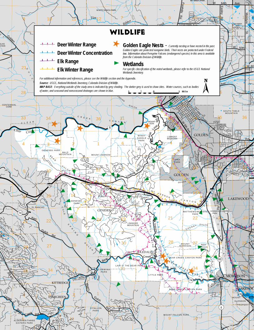
9 11 12 7 8 9 10 11 1210
16 14 13 18 17 16 15 14 1315
21 23 24 19 20 21 22 23 2422
28 26 25 30 29 28 27 26 2527
33 35 36 31 33 34 35 3634
4 2 1 6 4 2 13
9 11 12 7 8 9 10 11 1210
16 14 16 15 14 1315
21 23 24 19 21 22 23 2422
28 26 30 28 27 26 2527
33 35 31 34 3634
4 2 1 6 5 4 2 13
9 11 12 7 8 9 10 11 12
Golden
Gate
Canyon
Rd.
32nd
W 6th Ave.
BearCreek
Rd.
green
Pkw
y.
Foothills
Rd.
Ave.
McIntyre
W 64th Ave.
W 58th Ave.
W
W 50th
44t
Laria
t
Loop
Rd.
S
GoldenRd.
AlamedaPk
Rooney
Rd.
Craw
fordG
ulch
Kerr
GulchRd.
Myers
Gulch
Rd.
Easley
Rd.
Grapevine
Rd.
BearCreek
Rd.
Upper
St.
Rd.
W 66th Ave.
7070
6
40
74
74
40
58
93
40
470
93
470
70
B E A R C R E E K C A N Y O N
CO
LD
M T . V E R N O NC A N Y O N
SP
RI
NG
GU
LC
H
C L E A R
C R E E KC A N Y O N
C A N Y O N
G A T E
GO
LD
EN
N O R T H TA B L EM O U N TA I N
S O U T H TA B L EM O U N TA I N
CENTENNIALCONE
GLASNTAIN
UY
GU
LC
H
GUYHILL
SA
WM
IL
LG
UL
CH M O U N T
MORRISON
HO
GB
AC
K
C H E R R YG U L C H
LININGER
EL RANCHO
MOUNTAIN
APE
X
GU L C H
BE
AR
GU
L CH
BA L DMO U N TA I N
I ND IAN
G U L C H
TU
CK
ER
GU
LCH
C RESSMAN 'S
G U L C H
VAN BIBBERPARK
O P E N S PA C E
W HITE RANCH PARK
W I N D YS A D D L E
PA R K
G E N E S E E PA R K
HOGBACKPARK
MATTHEWS/WINTERSPA R K
R E DR O C K SPA R K
B E A R C R E E K C A N Y O N PA R K
L A I R O ' T H E B E A R PA R K
L I T T L E PA R K
M O U N T
G L E N N O N
P R O P E RT Y
M O U N T FA L C O N PA R K
O ' F A L L O NP A R K
A L D E R F E R / T H R E ES I S T E R S PA R K
OWK
GOLDEN
GOLDEN
LAKEWOOD
MORRISON
LAKEWOO
IDLEDALE
EVERGREEN
GENESEE
KITTREDGE
Van
BibberCreek
Clear Creek
LakeSoda
HL
Bear
Creek
B E A R C R E E K C A N Y O N PA R K
G E N E S E E PA R K
MO U N T V E R N O N
L OOKOUTMOUNTAIN
C O R W I N APA R K
Lookout Mtn
.
Rd.
8
285
MOUNTZION
A PEXPA R K
Deer Winter Range
Deer Winter Concentration
Elk Range
Elk Winter Range
Golden Eagle Nests - Currently nesting or have nested in the past.Golden Eagles are protected nongame birds. Their nests are protected under Federallaw. Information about Peregrine Falcons (endangered species) in this area is availablefrom the Colorado Division of Wildlife.
WetlandsFor specific classification of the noted wetlands, please refer to the USGS NationalWetlands Inventory.
1 012 1 Mile
For additional information and references, please see the Wildlife section and the Appendix.
Source: USGS, National Wetlands Inventory, Colorado Division of Wildlife.MAP BASE: Everything outside of the study area is indicated by grey shading. The darker grey is used to show cities. Water courses, such as bodiesof water, and seasonal and nonseasonal drainages are shown in blue.
WILDLIFE
erg
UU
G
LAD
R

th
k
OD
e
HL 9 11 12 7 8 9 10 11 1210
16 14 13 18 17 16 15 14 1315
21 23 24 19 20 21 22 23 2422
28 26 25 30 29 28 27 26 2527
33 35 36 31 32 33 34 35 3634
4 2 1 6 4 3 2 13
9 11 12 7 8 9 10 11 1210
16 14 16 15 14 1315
21 23 24 19 20 21 22 23 2422
28 26 25 30 29 28 27 26 2527
33 35 31 32 34 35 3634
4 2 1 6 5 4 3 2 13
9 11 12 7 8 9 10 11 12
Golden
Gate
Canyon
Rd.
32nd
W 6th Ave.
BearCreek
Rd.
ergreen
Pkw
y.
Foothills
Rd.
Ave.
McIntyre
W 64th Ave.
W 58th Ave.
W
W 50th
44
Laria
t
Loop
Rd.
S
GoldenRd.
AlamedaP
Rooney
Rd.
Craw
fordG
ulch
Kerr
GulchRd.
Myers
Gulch
Rd.
Easley
Rd.
Grapevine
Rd.
BearCreek
Rd.
Upper
St.
Rd.
W 66th Ave.
7070
6
40
74
74
40
58
93
40
470
93
470
70
B E A R C R E E K C A N Y O N
CO
LD
M T . V E R N O NC A N Y O N
SP
RI
NG
GU
LC
H
C L E A R
C R E E KC A N Y O N
C A N Y O N
G A T E
GO
LD
EN
N O R T H TA B L EM O U N TA I N
S O U T H TA B L EM O U N TA I N
CENTENNIALCONE
UGLASUNTAIN
UY
GU
LC
H
GUYHILL
SA
WM
IL
LG
UL
CH M O U N T
MORRISON
HO
GB
AC
K
C H E R R YG U L C H
LININGER
EL RANCHO
MOUNTAIN
APE
X
GU L C H
BE
AR
GU
L CH
BA L DMO U N TA I N
I ND IAN
G U L C H
TU
CK
ER
GU
LCH
C RESSMAN 'S
G U L C H
VAN BIBBERPARK
O P E N S PA C E
W HITE RANCH PARK
W I N D YS A D D L E
PA R K
G E N E S E E PA R K
HOGBACKPARK
MATTHEWS/WINTERSPA R K
R E DR O C K SPA R K
B E A R C R E E K C A N Y O N PA R K
L A I R O ' T H E B E A R PA R K
L I T T L E PA R K
M O U N T
G L E N N O N
P R O P E RT Y
M O U N T FA L C O N PA R K
O ' F A L L O NP A R K
A L D E R F E R / T H R E ES I S T E R S PA R K
KDOWR K
GOLDEN
GOLDEN
LAKEWOOD
MORRISON
LAKEWOO
IDLEDALE
EVERGREEN
GENESEE
KITTREDGE
Van
BibberCreek
Clear Creek
LakSoda
H
Bear
Creek
B E A R C R E E K C A N Y O N PA R K
G E N E S E E PA R K
MO U N T V E R N O N
L OOKOUTMOUNTAIN
C O R W I N APA R K
Lookout Mtn
.
Rd.
8
285
MOUNTZION
A PEXPA R K
100'
100'
30% SLOPE40% SLOPE100%
SLO
PE
Percent Slope = RiseRun
SLOPE
0-30%30-40% >40%
For additional information and references, please see Hazards sectionand the Glossary.
Source: USGS, Jefferson County GIS DepartmentMAP BASE: Everything outside of the study area is indicated by grayshading. The darker gray is used to show cities. Water courses, suchas bodies of water, and seasonal and nonseasonal drainages areshown in blue.
1 012 1 Mile

9 11 12 7 8 9 10 11 1210
16 14 13 18 17 16 15 14 1315
21 23 24 19 20 21 22 23 2422
28 26 25 30 29 28 27 26 2527
33 35 36 31 32 33 34 35 3634
4 2 1 6 4 3 2 13
9 11 12 7 8 9 10 11 1210
16 14 16 15 14 1315
21 23 24 19 20 21 22 23 2422
28 26 25 30 29 28 27 26 2527
33 35 31 32 34 35 3634
4 2 1 6 5 4 3 2 13
9 11 12 7 8 9 10 11 12
Golden
Gate
Canyon
Rd.
32nd
W 6th Ave.
BearCreek
Rd.
green
Pkw
y.
Foothills
Rd.
Ave.
McIntyre
W 64th Ave.
W 58th Ave.
W
W 50th
44th
Laria
t
Loop
Rd.
S
GoldenRd.
AlamedaPkw
Rooney
Rd.
Craw
fordG
ulch
Kerr
GulchRd.
Myers
Gulch
Rd.
Easley
Rd.
Grapevine
Rd.
BearCreek
Rd.
Upper
St.
Rd.
W 66th Ave.
7070
6
40
74
74
40
58
93
40
470
93
470
70
B E A R C R E E K C A N Y O N
CO
LD
M T . V E R N O NC A N Y O N
SP
RI
NG
GU
LC
H
C L E A R
C R E E KC A N Y O N
C A N Y O N
G A T E
GO
LD
EN
N O R T H TA B L EM O U N TA I N
S O U T H TA B L EM O U N TA I N
CENTENNIALCONE
GLASNTAIN
UY
GU
LC
H
GUYHILL
TOM
SA
WM
IL
LG
UL
CH M O U N T
MORRISON
HO
GB
AC
K
C H E R R YG U L C H
LININGER
EL RANCHO
MOUNTAIN
APE
X
GU L C H
BE
AR
GU
L CH
BA L DMO U N TA I N
I ND IAN
G U L C H
TU
CK
ER
GU
LCH
C RESSMAN 'S
G U L C H
VAN BIBBERPARK
O P E N S PA C E
W HITE RANCH PARK
W I N D YS A D D L E
PA R K
G E N E S E E PA R K
HOGBACKPARK
MATTHEWS/WINTERSPA R K
R E DR O C K SPA R K
B E A R C R E E K C A N Y O N PA R K
L A I R O ' T H E B E A R PA R K
L I T T L E PA R K
M O U N T
G L E N N O N
P R O P E RT Y
M O U N T FA L C O N PA R K
O ' F A L L O NP A R K
A L D E R F E R / T H R E ES I S T E R S PA R K
OWK
GOLDEN
GOLDEN
LAKEWOOD
MORRISON
LAKEWOOD
IDLEDALE
EVERGREEN
GENESEE
KITTREDGE
Van
BibberCreek
Clear Creek
LakeSoda
HL
Bear
Creek
B E A R C R E E K C A N Y O N PA R K
G E N E S E E PA R K
MO U N T V E R N O N
L OOKOUTMOUNTAIN
C O R W I N APA R K
Lookout Mtn
.
Rd.
8
285
MOUNTZION
A PEXPA R K
HighModerateLow
1 012 1 Mile
WILDFIRE HAZARDFor additional information and references, please see the Hazardsection and the Appendix..
A description of the levels of fire danger may be found in the Glossary.Source: Colorado State Forest Service, Jefferson County PlanningDepartment and Jefferson County GIS Department.
MAP BASE: Everything outside of the study area is indicated bygray shading. The darker gray is used to show cities. Water courses,such as bodies of water, and seasonal and nonseasonal drainagesare shown in blue.
erg
UU
KDR

h
kw
D
e
HyL 9 11 12 7 8 9 10 11 1210
16 14 13 18 17 16 15 14 1315
21 23 24 19 20 21 22 23 2422
28 26 25 30 29 28 27 26 2527
33 36 31 33 34 35 3634
4 2 1 6 4 3 2 1
9 11 12 7 8 9 10 11 1210
16 14 16 15 14 1315
21 23 24 19 20 21 22 23 2422
28 26 25 30 29 28 27 26 2527
33 35 31 32 34 3634
4 2 1 6 5 4 3 23
9 11 12 7 8 9 10 11 12
Golden
Gate
Canyon
Rd.
32nd
W 6th Ave.
BearCreek
Rd.
rgreen
Pkw
y.
Foothills
Rd.
Ave.
McIntyre
W 64th Ave.
W 58th Ave.
W
W 50th
44t
Laria
t
Loop
Rd.
S
GoldenRd.
AlamedaPk
Rooney
Rd.
Craw
fordG
ulch
Kerr
GulchRd.
Myers
Gulch
Rd.
Easley
Rd.
Grapevine
Rd.
BearCreek
Rd.
Upper
St.
Rd.
W 66th Ave.
7070
6
40
74
74
40
58
93
40
470
93
470
70
B E A R C R E E K C A N Y O N
CO
LD
M T . V E R N O NC A N Y O N
SP
RI
NG
GU
LC
H
C L E A R
C R E E KC A N Y O N
C A N Y O N
G A T E
GO
LD
EN
N O R T H TA B L EM O U N TA I N
S O U T H TA B L EM O U N TA I N
CENTENNIALCONE
UGLASNTAIN
UY
GU
LC
H
GUYHILL
TOM
SA
WM
IL
LG
UL
CH M O U N T
MORRISON
HO
GB
AC
K
C H E R R YG U L C H
LININGER
EL RANCHO
MOUNTAIN
APE
X
GU L C H
BE
AR
GU
L CH
BA L DMO U N TA I N
I ND IAN
G U L C H
TU
CK
ER
GU
LCH
C RESSMAN 'S
G U L C H
VAN BIBBERPARK
O P E N S PA C E
W HITE RANCH PARK
W I N D YS A D D L E
PA R K
G E N E S E E PA R K
HOGBACKPARK
MATTHEWS/WINTERSPA R K
R E DR O C K SPA R K
B E A R C R E E K C A N Y O N PA R K
L A I R O ' T H E B E A R PA R K
L I T T L E PA R K
M O U N T
G L E N N O N
P R O P E RT Y
M O U N T FA L C O N PA R K
O ' F A L L O NP A R K
A L D E R F E R / T H R E ES I S T E R S PA R K
KDOWR K
GOLDEN
GOLDEN
LAKEWOOD
MORRISON
LAKEWOOD
IDLEDALE
EVERGREEN
GENESEE
KITTREDGE
Van
BibberCreek
Clear Creek
LakeSoda
HL
Bear
Creek
B E A R C R E E K C A N Y O N PA R K
G E N E S E E PA R K
MO U N T V E R N O N
L OOKOUTMOUNTAIN
C O R W I N APA R K
Lookout Mtn
.
Rd.
8
285
MOUNTZION
A PEXPA R K
ENVIRONMENTAL CONSTRAINTS
Mines - Inactive 1 (source)Quarries - Active 1Quarries - Inactive 1Claypits - Inactive 1Known Radioactive Materials 2Floodplain Hazard Overlay Zone District 3Geologic Hazard Overlay Zone District 4Substation 5230 Kilovolt Overhead Electric Transmission Line 5115 Kilovolt Overhead Electric Transmission Line 5
Single Communication Tower 6
Multiple Communication Towers 6Other environmental constraints, i.e. wetlands, may be depicted on other maps.
For additional information and references, please see Hazard section and Appendix.
Source: 1 - USGS Quad Maps, Mine Land Index Map, Jefferson County PlanningDepartment; 2 - CAPP, Jefferson County Planning Department; 3- FEMA FloodInsurance Program; 4 - Jefferson County Geologic Hazards Overlay Zoning Maps;5 - Public Service Company; 6 - Jefferson County Planning Department
MAP BASE: Everything outside of the study area is indicated by gray shading. The darker gray is used to show cities. Water courses, such as bodies of water,and seasonal and nonseasonal drainages are shown in blue.
1 012 1 Mile

9 11 12 7 8 9 10 11 1210
16 14 13 18 17 16 15 14 1315
21 23 24 19 20 21 22 23 2422
28 26 25 30 29 28 27 26 2527
33 35 36 31 32 33 34 35 3634
4 2 1 6 4 3 13
9 11 7 8 9 10 1110
16 14 16 15 14 1315
21 23 24 19 20 21 22 2422
28 26 30 29 28 27 2527
33 35 31 32 34 35 3634
4 2 1 6 5 4 3 2 13
9 11 12 7 8 9 10 11 12
Mt. CarbonMetropolitan
District
Forest HillsMetropolitan
District
Mt. VernonMetropolitan
District
Golden Gate F.P.D.
Fairmount F.P.D.
Golden F.P.D.
Bancroft F.P.D.
Idledale F.P.D.
Lookout Mtn. F.P.D.
Idledale F.P.D.
Evergreen F.P.D.
Lookout Mtn. F.P.D.
Indian Hills F.P.D.
Genesee F.P.D.
Mt. VernonF.P.D.
Lookout Mtn. F.P.D.Pleasant View
F.P.D.
LakewooF.P.D.
Arvada F.P.D.
Golden F.P.D.Lakewood F.P.
Evergreen RecreationDistrict
Evergreen Recreation District.
Evergreen RecreationDistrict
Golden
Gate
Canyon
Rd.
32nd
W 6th Ave.
BearCreek
Rd.
een
Pkw
y.
Foothills
Rd.
Ave.
McIntyre
W 64th Ave.
W 58th Ave.
W
W 50th
44th
Laria
t
Loop
Rd.
S
GoldenRd.
AlamedaPkwy
Rooney
Rd.
Craw
fordG
ulch
Kerr
GulchRd.
Myers
Gulch
Rd.
Easley
Rd.
Grapevine
Rd.
BearCreek
Rd.
Upper
St.
Rd.
W 66th Ave.
7070
6
40
74
74
40
58
93
40
470
93
470
70
B E A R C R E E K C A N Y O N
CO
LD
M T . V E R N O NC A N Y O N
SP
RI
NG
GU
LC
H
C L E A R
C R E E KC A N Y O N
C A N Y O N
G A T E
GO
LD
EN
N O R T H TA B L EM O U N TA I N
S O U T H TA B L EM O U N TA I N
CENTENNIALCONE
LASTAIN
Y
GU
LC
H
GUYHILL
TOM
SA
WM
IL
LG
UL
CH M O U N T
MORRISON
HO
GB
AC
K
C H E R R YG U L C H
LININGER
EL RANCHO
MOUNTAIN
APE
X
GU L C H
BE
AR
GU
L CH
BA L DMO U N TA I N
I ND IAN
G U L C H
TU
CK
ER
GU
LCH
C RESSMAN 'S
G U L C H
VAN BIBBERPARK
O P E N S PA C E
W HITE RANCH PARK
W I N D YS A D D L E
PA R K
G E N E S E E PA R K
HOGBACKPARK
MATTHEWS/WINTERSPA R K
R E DR O C K SPA R K
B E A R C R E E K C A N Y O N PA R K
L A I R O ' T H E B E A R PA R K
L I T T L E PA R K
M O U N T
G L E N N O N
P R O P E RT Y
M O U N T FA L C O N PA R K
O ' F A L L O NP A R K
A L D E R F E R / T H R E ES I S T E R S PA R K
W
GOLDEN
GOLDEN
LAKEWOOD
MORRISON
LAKEWOOD
IDLEDALE
EVERGREEN
GENESEE
KITTREDGE
Van
BibberCreek
Clear Creek
LakesSoda
HyaLak
Bear
Creek
B E A R C R E E K C A N Y O N PA R K
G E N E S E E PA R K
MO U N T V E R N O N
L OOKOUTMOUNTAIN
C O R W I N APA R K
Lookout Mtn
.
Rd.
8
285
MOUNTZION
A PEXPA R K
PUBLIC SERVICES & FACILITIESMetropolitan DistrictsFire Protection Districts (F.D.P)No Fire Protection DistrictRecreational DistrictsFire StationsRescue ServicesCommunity Center BuildingsWater/Wastewater Treatment PlantsSchools
Please refer to Summary Map for Water and Sanitation Districts.
For additional information and references please see Public Services & Facilities section and Appendix.
Source: Jefferson County GIS Department, Jefferson County Planning DepartmentMAP BASE: Everything outside of the study area is indicated by gray shading. The darker gray is used to show cities.Water courses, such as bodies of water, and seasonal and nonseasonal drainages are shown in blue.
1 012 1 Mile

o
.
y
ak 9 11 12 7 8 9 10 11 1210
16 14 13 18 17 16 15 14 1315
21 23 24 19 20 21 22 23 2422
28 26 25 30 29 28 27 26 2527
33 35 36 31 32 33 34 35 3634
4 2 1 6 4 3 2 13
9 11 12 7 8 9 10 11 1210
16 14 16 15 14 1315
21 23 24 19 20 21 22 23 2422
28 26 25 30 29 28 27 26 2527
33 35 31 32 34 35 3634
4 2 1 6 5 4 3 2 13
9 11 12 7 8 9 10 11 12
Golden
Gate
Canyon
Rd.
32nd
W 6th Ave.
BearCreek
Rd.
ergreen
Pkw
y.
Foothills
Rd.
Ave.
McIntyre
W 64th Ave.
W 58th Ave.
W
W 50th
44t
Laria
t
Loop
Rd.
S
GoldenRd.
AlamedaPk
Rooney
Rd.
Craw
fordG
ulch
Kerr
GulchRd.
Myers
Gulch
Rd.
Easley
Rd.
Grapevine
Rd.
BearCreek
Rd.
Upper
St.
Rd.
W 66th Ave.
7070
6
40
74
74
40
58
93
40
470
93
470
70
B E A R C R E E K C A N Y O N
CO
LD
M T . V E R N O NC A N Y O N
SP
RI
NG
GU
LC
H
C L E A R
C R E E KC A N Y O N
C A N Y O N
G A T E
GO
LD
EN
N O R T H TA B L EM O U N TA I N
S O U T H TA B L EM O U N TA I N
CENTENNIALCONE
UGLASUNTAIN
UY
GU
LC
H
GUYHILL
TOM
SA
WM
IL
LG
UL
CH M O U N T
MORRISON
HO
GB
AC
K
C H E R R YG U L C H
LININGER
EL RANCHO
MOUNTAIN
APE
X
GU L C H
BE
AR
GU
L CH
BA L DMO U N TA I N
I ND IAN
G U L C H
TU
CK
ER
GU
LCH
C RESSMAN 'S
G U L C H
VAN BIBBERPARK
O P E N S PA C E
W HITE RANCH PARK
W I N D YS A D D L E
PA R K
G E N E S E E PA R K
HOGBACKPARK
MATTHEWS/WINTERSPA R K
R E DR O C K SPA R K
B E A R C R E E K C A N Y O N PA R K
L A I R O ' T H E B E A R PA R K
L I T T L E PA R K
M O U N T
G L E N N O N
P R O P E RT Y
M O U N T FA L C O N PA R K
O ' F A L L O NP A R K
A L D E R F E R / T H R E ES I S T E R S PA R K
KDOWR K
GOLDEN
GOLDEN
LAKEWOOD
MORRISON
LAKEWOO
IDLEDALE
EVERGREEN
GENESEE
KITTREDGE
Van
BibberCreek
Clear Creek
LakeSoda
HL
Bear
Creek
B E A R C R E E K C A N Y O N PA R K
G E N E S E E PA R K
MO U N T V E R N O N
L OOKOUTMOUNTAIN
C O R W I N APA R K
Lookout Mtn
.
Rd.
8
285
MOUNTZION
A PEXPA R K
Mt. VernonMetropolitan
District
Forest HillsMetropolitan
District
Mt. CarbonMetropolitan
District
Lookout Mtn.Water District
IdledaleWater
GeneseeWater District
D 5,700F 25,500
C 4,100C 5,000
B 2,300D 8,080F 36,000
45,200DRCOG 2010
Projection
104,000
3,400
3,700
37,900
B 2,000C 3,280F 16,000
B 2,350D 6,750F 26,200
B 1,400B 2,250E 5,600
E 10,800E 10,800
B 3,600D 10,000F 30,600
C 4,000E 11,300E 11,000
C 3,0003,400
A 191C 3,800D 6,600
Potential Traffic Volumes Levels of Service Additional LOS information is available in the Appendix.
Existing traffic countTraffic count based on Plan recommendationsTraffic count based on buildout of existing zoning
1 012 1 Mile
COMPOSITEMetropolitan DistrictsScenic Corridors Please see specific Visual Resource Maps.
Water & Sanitation Districts Not all properties within adistrict are necessarily served.
Neighborhood Centers
For additional information and references, please see the Visual Resource, Water and Sanitation, Housing, Commercial and OfficeDevelopment, and Transportation sections and the Appendix.
Source: Jefferson County Highways and Transportation, Jefferson County Planning Department, and Jefferson County GIS Department.MAP BASE: Everything outside of the study area is indicated by gray shading. The darker gray is used to show cities. Water courses,such as bodies of water, and seasonal and nonseasonal drainages are shown in blue.
A 000000B 000000C 000000
Average Daily Traffic