Embed Size (px)
Citation preview


Celestino Jimboomba - Planning Report
Document Control
Document: Celestino Jimboomba - Town Planning Report This document has been prepared for:
Contact: Mr Lloyd Gomez Development Manager Celestino Pty Limited PO Box 438
Pendle Hill NSW 2145 [email protected] This document has been prepared by:
Project Team: Contact: Nicole Boulton
PSA Consulting (Australia) Pty Ltd PO Box 10824, Adelaide Street, Brisbane QLD 4000 Telephone +61 7 3220 0288 [email protected] www.psaconsult.com.au
Revision History
VERSION DATE DETAILS AUTHOR AUTHORISATION
2 8 November 2016 FINAL Nicole Boulton
David Ireland
General Disclaimer The information contained in this document produced by PSA Consulting (Australia) Pty Ltd is for the use of Celestino Pty Limited for the purpose for which it has been prepared and PSA Consulting (Australia) Pty Ltd undertakes no duty of care to or accepts responsibility to any third party who may rely upon this document.
All rights reserved. No section or element of this document may be removed from this document, reproduced, electronically stored or transmitted in any form without the written permission of PSA Consulting (Australia) Pty Ltd.

0546 – 8 November 2016 – V2
TABLE OF CONTENTS
1 INTRODUCTION .................................................................................................................................................. 1
2 CONTEXT ............................................................................................................................................................. 2
2.1 PRIORITY DEVELOPMENT AREA CONTEXT ................................................................................................................. 2 2.2 SITE DESCRIPTION ...................................................................................................................................................... 3 2.3 SITE AND APPLICATION HISTORY ............................................................................................................................... 3 2.4 SURROUNDING LAND USES ........................................................................................................................................ 4
3 PRE-LODGEMENT DISCUSSIONS .......................................................................................................................... 6
3.1 ECONOMIC DEVELOPMENT QUEENSLAND ................................................................................................................ 6 3.2 LOGAN CITY COUNCIL ................................................................................................................................................ 6
4 APPLICATION SUMMARY .................................................................................................................................... 7
4.1 ASPECTS OF DEVELOPMENT SEEKING APPROVAL ...................................................................................................... 7 4.2 CONTEXT PLAN ENDORSEMENT ................................................................................................................................. 7 4.3 MASTER PLAN............................................................................................................................................................. 7 4.4 FUTURE APPLICATIONS .............................................................................................................................................. 7
5 CONTEXT PLAN ................................................................................................................................................... 8
5.1 AREA ANALYSIS........................................................................................................................................................... 8 5.2 CONTEXT PLAN ......................................................................................................................................................... 12 5.3 INFRASTRUCTURE..................................................................................................................................................... 17
6 CELESTINO JIMBOOMBA MASTER PLAN ........................................................................................................... 19
6.1 PURPOSE OF THE MASTER PLAN .............................................................................................................................. 19 6.2 DESIGN PRINCIPLES .................................................................................................................................................. 19 6.3 DEVELOPMENT SUMMARY ...................................................................................................................................... 20 6.4 LAND USE AREAS ...................................................................................................................................................... 22 6.5 INFRASTRUCTURE ASSESSMENT AND PROVISION ................................................................................................... 25 6.6 FLOODING AND STORMWATER MANAGEMENT ...................................................................................................... 29 6.7 ECOLOGICAL IMPACT ASSESSMENT ......................................................................................................................... 32
7 PLANNING ASSESSMENT ................................................................................................................................... 34
7.1 SUSTAINABLE PLANNING ACT 2009 ......................................................................................................................... 34 7.2 PLANNING ACT 2016 ................................................................................................................................................ 34 7.3 SEQ REGIONAL PLANNING ....................................................................................................................................... 34 7.4 ECONOMIC DEVELOPMENT ACT 2012 ..................................................................................................................... 35 7.5 GREATER FLAGSTONE DEVELOPMENT SCHEME ...................................................................................................... 35 7.6 EDQ GUIDELINES ...................................................................................................................................................... 36 7.7 EDQ PRACTICE NOTES .............................................................................................................................................. 42 7.8 COMMONWEALTH LEGISLATION ............................................................................................................................. 43
8 CONCLUSION .................................................................................................................................................... 44
APPENDIX 1 – TITLE SEARCHES APPENDIX 2 – PRE-LODGEMENT DISCUSSIONS APPENDIX 3 – CONTEXT PLAN APPENDIX 4 – MASTER PLAN APPENDIX 5 – FLOOD INVESTIGATION REPORT APPENDIX 6 – TRAFFIC IMPACT ASSESSMENT APPENDIX 7 – WATER AND WASTEWATER INFRASTRUCTURE MASTER PLAN APPENDIX 8 – CONCEPT STORMWATER MANAGEMENT PLAN APPENDIX 9 – ASSESSMENT AGAINST THE DEVELOPMENT SCHEME APPENDIX 10 – GREENSPACE INFRASTRUCTURE MANAGEMENT PLAN APPENDIX 11 – ECOLOGICAL ASSESSMENT REPORT APPENDIX 12 – ILLUSTRATIVE MASTER PLAN

0546 – 8 November 2016 – V2
LIST OF FIGURES
Figure 1: Greater Flagstone PDA Boundary (Economic Development Queensland, 2011) ....................................................... 2 Figure 2: Wider Context of the Subject Site (Google Earth, 2016) ............................................................................................ 5 Figure 3: Vision for the Greater Flagstone Development Scheme (ULDA, 2011) ...................................................................... 9 Figure 4: Current Flood Extents - 1% AEP Maximum Extent (Calibre Consulting, 2016)......................................................... 10 Figure 5: Greater Flagstone Natural Features (Greater Flagstone Development Scheme 2011) ........................................... 11 Figure 6: Greater Flagstone Community Greenspace Network (Greater Flagstone Development Scheme 2011) ................. 11 Figure 7: Greater Flagstone Centres and Transport Network (Greater Flagstone Development Scheme 2011) .................... 12 Figure 8: Proposed Context Plan (THG, 2016) ........................................................................................................................ 13 Figure 9: Context Plan Residential (THG, 2016) ...................................................................................................................... 14 Figure 10: Context Plan Centres network (THG, 2016) ........................................................................................................... 15 Figure 11: Context Plan Open Space (THG, 2016) ................................................................................................................... 16 Figure 12: Context Plan Community Facilities (THG, 2016) .................................................................................................... 17 Figure 13: Context Plan Infrastructure (THG, 2016) ............................................................................................................... 18 Figure 14: Celestino Jimboomba Master Plan (THG, 2016). ................................................................................................... 20 Figure 15: Greenspace Network Plan (Saunders Havill, 2016) ............................................................................................... 24 Figure 16: Potential Bus Stop Locations (ARUP, 2016) ........................................................................................................... 26 Figure 17: Option 1 Water Supply Service Strategy (Calibre Consulting, 2016) ..................................................................... 27 Figure 18: Option 2 Water Supply Service Strategy (Calibre Consulting, 2016) ..................................................................... 28 Figure 19: Conceptual Ultimate Wastewater Service Strategy (Calibre Consulting, 2016) .................................................... 29 Figure 20: Developed Scenario 1% AEP Maximum Flood Depth Plan (Calibre Consulting, 2016) .......................................... 30 Figure 21: Stormwater Quantity Management (Source: Calibre 2016) .................................................................................. 31 Figure 22: Concept Stormwater Quality Management Plan (Calibre Consulting, 2016) ........................................................ 32 Figure 23: Vegetation Communities over subject site (Saunders Havill, 2016) ...................................................................... 33
LIST OF TABLES Table 1: Site Details .................................................................................................................................................................. 3 Table 2: Approvals Summary .................................................................................................................................................... 4 Table 3: Context Plan Development Summary ....................................................................................................................... 13 Table 4: Master Plan Development Summary ........................................................................................................................ 20 Table 5: Celestino Jimboomba Approved Land Use Table...................................................................................................... 21 Table 6: Residential Development Provisions ........................................................................................................................ 22 Table 7: Centre Development Provisions ............................................................................................................................... 22 Table 8: Assessment Against Guideline no. 5 - Neighbourhood Planning and Design ........................................................... 36 Table 9: Assessment Against Guideline 9: Centres ................................................................................................................. 39
LIST OF ACRONYMS AND ABBREVIATIONS
Applicant Celestino Pty Limited
CBD Brisbane Central Business District
Celestino Celestino Pty Limited
CPTED Crime prevention through environmental design
Development Scheme Greater Flagstone Development Scheme
DoEE Department of the Environment and Energy (Commonwealth)
ED Act Economic Development Act 2012
EDQ Economic Development Queensland
EPBC Act Environmental Protection and Biodiversity Conservation Act 1999
ha hectare
IFF Infrastructure Funding Framework
ILUP Integrated Land Use Plan
IMP Infrastructure Master Plan
km Kilometre

0546 – 8 November 2016 – V2
LCC Logan City Council
LGA Local government area
LWIA Logan Water Infrastructure Alliance
MCU Material Change of Use
OPW Operational Works
OSS Overall Site Strategy
PDA Priority Development Area
Planning Act Planning Act 2016
POD Plan of Development
PSA PSA Consulting
Q100 A flood event that has the probability of occurring once in every 100 years
ROL Reconfiguring of a Lot
SARA State Assessment and Referral Agency
SEQ South East Queensland
SEQ Regional Plan South East Queensland Regional Plan 2009-2031
SPA Sustainable Planning Act 2009
SPS Secondary pumping station
Subject site The lots listed in Table 1 of this report
UDA Urban Development Area
ULDA Act Urban Land Development Authority Act 2007

0546 – 8 November 2016 – V2 1
1 INTRODUCTION
PSA Consulting Australia (PSA) has prepared this planning report to support a Development Application on behalf of Celestino Pty Limited (Celestino), the land owner and applicant, for the development of the Celestino Jimboomba Master Planned Community within the Greater Flagstone Priority Development Area.
The application seeks approval from Economic Development Queensland (EDQ) for the following aspects:
Preliminary Approval for Development Generally In Accordance with the Celestino Jimboomba Master Plan; and
Endorsement of a Context Plan.
The Context Plan will not form part of the approval, but is sought to be endorsed by EDQ. The Context Plan has been developed in accordance with the requirements of the Greater Flagstone Development Scheme and Practice Note No. 09 and broadly shows how the subject site and surrounding land is to be developed.
The Celestino Jimboomba Master Plan details the long term development intent for the subject site, including:
Approximately 7,000 residential lots to be delivered in 27 stages, through subsequent Reconfiguring a Lot (ROL) Development Applications;
A Primary School;
A District and Neighbourhood Centre;
Recreational facilities, being a District Sports Park, Regional Recreation Park, Neighbourhood and Local Parks and Community Facilities.
Upon completion, the site will have a total residential population of approximately 20,000 people.
This planning report and the supporting technical studies demonstrate compliance with the relevant statutory considerations including the Greater Flagstone PDA Development Scheme, the EDQ Guidelines and Practice Notes. Further, the site is able to be appropriately serviced with all necessary urban infrastructure in both the short and long term, without compromising the ecological qualities of the site.
This Development Application seeks to put in place an overarching strategic framework that guides the development and delivery of the Celestino Jimboomba Master Planned Community. Future applications will be submitted to EDQ for Material Change of Use (MCU) or Reconfiguring a Lot (ROL) in accordance with the Context Plan and Approved Master Plan. Plans of Development (PODs) will also be submitted with the relevant applications, enabling consistent development in accordance with the POD to progress as Exempt Development under the Development Scheme.
The land which comprises the subject site and is the focus of the Development Application includes:
72 Riverbend Boulevard, Jimboomba (Lot 800 SP247625);
1434 - 1586 Teviot Road, Jimboomba (Lot 101 SP254145);
155 - 243 Bushland Road, Jimboomba (Lot 102 SP254145);
245 - 247 Bushland Road, Jimboomba (Lot 104 SP254145);
1394 - 1432 Teviot Road, Jimboomba (Lot 105 SP254145); and
1294 - 1352 Teviot Road, Jimboomba (Lot 106 SP254145).
The report provides an assessment of the development against the relevant planning instruments, including the Greater Flagstone PDA Development Scheme (the Development Scheme) and the relevant sections of the Economic Development Act 2012 (ED Act).

0546 – 8 November 2016 – V2 2
2 CONTEXT
2.1 PRIORITY DEVELOPMENT AREA CONTEXT
The subject site is located within the Greater Flagstone Priority Development Area (PDA), which was formerly referred to as the Greater Flagstone Urban Development Area (UDA). The UDA was declared on 8 October 2010 under the Urban Land Development Authority Act 2007 (ULDA Act). The ULDA Act has since been superseded by the Economic Development Act 2012. On the same date as the UDA was declared, the Greater Flagstone Interim Land Use Plan (ILUP) also commenced. The ILUP has since been superseded by the Development Scheme as the primary land use planning document for development assessment within the PDA. The Development Scheme commenced in October 2011 and remains in force and effect.
The Greater Flagstone PDA is located approximately 40km south west from the Brisbane CBD and is within the Logan City Council (LCC) Local Government Area (LGA). The PDA is split into three separate areas, with the subject site being located within the southernmost area (see Figure 1), which is referred to in the Development Scheme as ‘Flagstone’.
Figure 1: Greater Flagstone PDA Boundary (Economic Development Queensland, 2011)
Subject Site
Context Plan Area

0546 – 8 November 2016 – V2 3
The Greater Flagstone PDA is situated within an urban growth corridor that is identified within an Identified Growth Area under the South East Queensland Regional Plan 2009-2031 and within the Urban Footprint under the recently released Draft SEQ Regional Plan 2016. The vision for the Greater Flagstone PDA is outlined in Section 2.2 of the Development Scheme. Broadly, the PDA is intended to accommodate a large, integrated urban community comprised of:
An estimated urban population of 100,000 to 120,000 people accommodated in attractive, compact, vibrant and connected residential neighbourhoods;
Unique urban environments which have a strong sense of place, capitalise on and are connected to the natural features of the PDA including the Logan River and Teviot Brook;
An urban form that ensures ecological values are protected and enhanced and adequate community green space and recreation opportunities are provided;
A wide range of facilities and services located within a network of easily accessible and dynamic activity centres and low impact business and industry areas;
A high level of supporting infrastructure and services including connected private, public and active transport opportunities; and
An extensive network of environmental and open space corridors that frame neighbourhoods and provide attractive transport links.
The PDA Vision Statement has been used by the project team as part of the development of the Context Plan and Master Plan to ensure the Celestino Jimboomba Master Plan is contributing to achieving the wider vision.
2.2 SITE DESCRIPTION
The subject site is comprised of six lots which are summarised in Table 1 below.
Table 1: Site Details
STREET ADDRESS REAL PROPERTY DESCRIPTION
PROPERTY OWNER LOT SIZE
(ha)
72 Riverbend Boulevard, Jimboomba 800 SP247625 EJC Riverbend Pty Ltd 310.38
155-243 Bushland Road, Jimboomba 102 SP254145 EJC Riverbend Pty Ltd 50.85
1394-1432 Teviot Road, Jimboomba 105 SP254145 EJC Riverbend Pty Ltd 23.5
1294-1352 Teviot Road, Jimboomba 106 SP254145 EJC Riverbend Pty Ltd 43.33
1434-1586 Teviot Road, Jimboomba 101 SP254145 Anthony Charles Gittens 91.54
245-247 Bushland Road, Jimboomba 104 SP254145 Anthony Charles Gittens 31.2
TOTAL 550.8 HA
Copies of title searches for each of the subject lots are included in Appendix 1. Lot 800 has been historically known as ‘Riverbend’ and the remaining lots have previously formed part of ‘Teviot Brook’. Each of the relevant lots are held by the above entities in freehold.
2.3 SITE AND APPLICATION HISTORY
The site has traditionally been used for cattle grazing and has been historically cleared and maintained for this purpose. Since the commencement of the Urban Land Development Act 2007, the ULDA / EDQ has issued 2 Development Approvals over the site which remain in force and effect. An overview of these approvals is provided in Table 2 below. Additional land outside of the subject site was included in the EDQ Application referenced as DEV2012/312.
It is important to note that while these approvals remain in force and effect; this Development Application is not a related application and is lodged separately to these approvals.

0546 – 8 November 2016 – V2 4
Table 2: Approvals Summary
REAL PROPERTY DESCRIPTION APPROVAL DESCRIPTION CURRENCY PERIOD
“RIVERBEND” - EDQ REFERENCE: DEV2012/244
Lot 800 SP247625 Material Change of Use:
1. For the uses set out in the application generally in accordance with Riverbend Whole of Site Plan, Drawing number BA2544-WOS01_C, dated 31.08.12
2. In respect to the land the subject of the application
30 years
“TEVIOT BROOK” - EDQ REFERENCE: DEV2012/312
Lot 79 S313001
Lot 310 S311660
Lot 306 S311476
Lot 153 SL11068
Lot 78 S313001
Lot 86 SL5122
Lot 156 SL11068
Lot 157 SL11068
Lot 299 S311316
Lot 168 SL11068
Lot 169 SL11068
Lot 23 SP142997
Lot 24 SP142997
Lot 25 SP142997
1. Material change of use for multiple uses (over whole of site).
2. Reconfiguring a lot (6 into 6 lots).
35 years
2.4 SURROUNDING LAND USES
The subject site is surrounded by a mix of large lot rural land and smaller rural residential uses to the north, east and west. Large tracts of undeveloped rural land are located to the south including the site of the proposed Cedar Grove Waste Water Treatment Plant on the southern side of the Logan River. The subject site is immediately bounded by the Logan River to the east and south and adjoins a camping reserve (State owned land under the trusteeship of Logan City Council) to the north on Lot 102 on SP254145.
Further afield, the Jimboomba Township and the Mount Lindesay Highway are located approximately 3.8km to the east of the subject site. Jimboomba offers a full size supermarket, along with smaller convenience retail and fast food outlets. There are also civic services, such as a local library and police station in the same area.
Approximately 15km to the south of the subject site is the township of Beaudesert, which provides high order retail, commercial, education and civic services. Further north is the extent of the greater Brisbane urban fringe including the activity centres of Park Ridge, Springfield and the southern suburbs of Brisbane City. An aerial photo of the site and surrounding area is provided in Figure 2.

0546 – 8 November 2016 – V2 5
Figure 2: Wider Context of the Subject Site (Google Earth, 2016)

0546 – 8 November 2016 – V2 6
3 PRE-LODGEMENT DISCUSSIONS
3.1 ECONOMIC DEVELOPMENT QUEENSLAND
A pre-application discussion was held with EDQ on 12 August 2016. In summary, the items discussed were as follows:
EDQ was generally supportive with the Draft Context Plan / Master Plans presented.
Supporting Material and Engineering Reports were requested and should address the following items:
Stormwater & Flooding
o Any proposed lake or detention basins;
o Expected changes to flood behaviour as a result of the Development Application;
Traffic and Transport
o Provision for bus services within the road network;
o Trunk collector roads and their connections with Teviot Road;
o Road cross sections to be adopted;
Water and Wastewater
o The location and interaction with the proposed Water Treatment Plant and Cedar Grove Wastewater Treatment Plants;
o Ultimate water supply arrangements for the subject site and response to the SEQ Water Development Guidelines;
Soils
o Potential impacts of dispersive soils (if any);
Ecological
o Ecological Assessment Required; and
o Bushfire Management will need to be addressed.
Technical studies will be independently reviewed at the cost of the Applicant.
Public notification of the application will be required.
The site will be subject to value capture uplift charge as per the infrastructure funding framework (IFF).
Other meetings held with EDQ related to technical infrastructure matters, including roads, water supply, sewer supply, electricity, flooding and peak flow mitigation, stormwater quality and water sensitive urban design and earthworks. These discussions have provided the project team with the relevant guidance to prepare this application in accordance with the relevance standards, whilst taking into consideration the specific intricacies of the subject site. Records of these discussions are attached in Appendix 2.
3.2 LOGAN CITY COUNCIL
In order to assist in the preparation of the Water and Wastewater IMP, a meeting was held with EDQ and Logan Water Infrastructure Alliance (LWIA) on 5 October 2016 to discuss the proposed water and wastewater assumptions and planning for the subject site. Discussions during this meeting confirmed that EDQ and LWIA generally accepted the principles within the draft drawings presented at the meeting. A record of this discussion is included in Appendix 2.

0546 – 8 November 2016 – V2 7
4 APPLICATION SUMMARY
This Development Application seeks to put in place an overarching, strategic framework that guides the development and delivery of the Celestino Jimboomba Master Planned Community. Future applications will be submitted to EDQ for any Material Change of Use (MCU) or Reconfiguring a Lot (ROL) in accordance with the Context Plan and Approved Master Plan. Plans of Development (PODs) will also be submitted with the relevant applications enabling consistent development in accordance with the POD to progress as Exempt Development under the Development Scheme.
4.1 ASPECTS OF DEVELOPMENT SEEKING APPROVAL
The Applicant is seeking Preliminary Approval for development in accordance with the Celestino Jimboomba Master Plan and concurrent endorsement of a Context Plan.
4.2 CONTEXT PLAN ENDORSEMENT
As per Section 3.2.8 of the Development Scheme, Context Plans are prepared by Applicants and are required to accompany a Development Application for the first Permissible Development in the relevant Context Plan Area. A Context Plan is designed to provide the intermediate level of spatial planning between the Development Scheme maps and individual development proposals. The Context Plan shows a high level approach to development within the subject site, as well as the surrounding lots also included in the Context Plan Area.
The Context Plan forms part of the supporting information for the Development Application, but will not form part of the approval or approved documents. As such, the applicant is seeking the endorsement of the Context Plan (in Appendix 3) by EDQ. The Context Plan and its components are further discussed in Section 6 of this report.
4.3 MASTER PLAN
The Applicant is seeking a Preliminary Approval for development in accordance with the Celestino Jimboomba Master Plan (attached as Appendix 4). The master plan shows details of the long term development of the subject site, including:
7,000 lots to be subdivided over 27 stages, through reconfiguration of a lot (ROL) applications;
A Primary School to be developed by DETE;
A District and Neighbourhood Centre;
Recreational facilities, being a District Sports Park, Regional Recreation Park, multiple Pocket Parks and Community facilities.
The staging of the development will commence with the central part of the subject site (precincts 1.05 and 3), before moving to the eastern precincts, with the final precincts being delivered in the western part of the subject site. Development of these precincts will be subject to future Development Applications. It is anticipated that 200 lots per year will be developed (subject to market conditions). A list of approved uses has also been provided to articulate the supported land uses within each planning area presented on the Master Plan. The Master Plan and its components are further discussed in Section 7 of this report.
Consistent with the previous approvals on the site, and in response to the scale and delivery timeframe, the Applicant requests a Relevant Period (Currency) of 30 years be applied to the Preliminary Approval.
4.4 FUTURE APPLICATIONS
Future applications will be submitted to EDQ for any MCU or ROL applications, in accordance with the Context Plan and the Celestino Jimboomba Master Plan. A Plan of Development (POD) may be submitted with these applications to ensure that future development which is in accordance with the POD is exempt development and requires no further development approval under the Development Scheme.

0546 – 8 November 2016 – V2 8
5 CONTEXT PLAN
As per Section 3.2.8 of the Development Scheme, Context Plans are prepared by Applicants and are required to accompany a Development Application for the first Permissible Development in the relevant Context Plan Area. A Context Plan is designed to provide the intermediate level of spatial planning between the Development Scheme maps and individual development proposals. The Context Plan shows a high level approach to development within the subject site, as well as the surrounding lots also included in the Context Plan Area.
In preparing the Context Plan, a multi-disciplinary approach to the planning and design of the area has resulted in a quality, long-term plan which meets the UDA-wide criteria and responds to the site specific opportunities and constraints. The proposed Context Plan provides for the development of high quality, well planned and integrated neighbourhoods supported by centres, open space, community facilities and transport infrastructure. Ongoing liaison has been occurring with EDQ and LCC during the context planning process to ensure all matters are appropriately addressed. An analysis of the statutory drivers, opportunities and constraints, and presentation of the Context Plan is provided below.
5.1 AREA ANALYSIS
5.1.1 Greater Flagstone Urban Development Area Development Scheme
The vision for the Greater Flagstone PDA is set out in Section 2.2 of the Development Scheme, and indicates that “Flagstone will be a large integrated urban community of about 100,000 people living in attractive, compact neighbourhoods, and provided with a wide range of facilities and services located in a network of accessible activity centres and low impact business and industry areas. Flagstone will be characterised by an extensive network of environmental and open space corridors that frame neighbourhoods and provide active transport links”.
Other themes of the vision statement are:
A community framed by green landscapes;
A liveable community;
A prosperous community;
An inclusive community; and
A connected community.
The natural setting and scenic quality of the site and surrounding area has been a critical design driver for the Context Plan. In particular, the urban components of the Context Plan respond to areas of ecological significance and seek to retain natural and bushland settings, particularly in riparian areas and the land adjoining the Logan River. The Context Plan has also been designed to ensure significant views to the landscape and natural features are maintained, enhancing the sense of place and connection to the wider setting.
The Context Plan provides for a network of connected open space and recreation areas for residents to maximise liveability, takes advantage of the sub-tropical climate and encourages residents to be active and lead positive and healthy lifestyles.
The Context Plan allows for the delivery of a wide range of housing options, supported by community services including education and recreation facilities. It also provides for flexibility in the design and layout of future residential areas so that lot orientation and building design can adopt sustainable practices, maximise energy efficiency and reduce the impacts.
Consistent with the Development Scheme maps, a District and Neighbourhood Centres have been provided within the Context Plan Area. These centres will be focal points for community, retail, commercial and other services and will provide opportunities for local employment and business development.
A loop road is to be provided connecting key nodes and activity centres with the Context Plan Area, including the District Centre, Neighbourhood Centres, District Sports and Regional Recreation Parks and the residential areas. The road network is supported by a series of pedestrian and cycleways, providing safe passage for non-motorised transport through the urban areas and integrating with open space areas of the site, particularly the linear spaces along the drainage corridor and along the Logan River.

0546 – 8 November 2016 – V2 9
Overall, it is considered that the proposed Context Plan is consistent with and advances the vision for the Greater Flagstone PDA. An assessment of the development against the relevant sections of the Development Scheme is provided in Section 8.2.
Figure 3: Vision for the Greater Flagstone Development Scheme (ULDA, 2011)
5.1.2 Land Form and Topography
The key topographic features of the site that have influenced the Context Plan and urban form are:
A ridgeline which traverses the area from east to west along the southern boundary;
A ridgeline that traverses the site east to west in the northern sector of the subject land;
A significant drainage corridor that commences in the west of the Context Plan Area site and widens to a relatively flat, wide flood plain in the east prior to discharge into the Logan River; and
Generally steeply rising banks of the Logan River on the eastern and southern parts of the Context Plan Area.
As the majority of the area exhibits slopes between 0 – 10%, with steeper slopes (16% and above) generally localised in gully areas, the land provides sympathetic topography that will facilitate a diverse range of allotments without the need for significant earthworks. Generally, major earthworks will be limited to the gullies and immediate environs to enable suitable sites to support the required density of urban development.
Walkability is a key design driver for the Context Plan and the gentle slopes allow for ease of movement along future streets and open space corridors. The layout of the area has been designed to sympathetically integrate into the natural topography with major road corridors linking key elements of the future community. Similarly, the major road network has been sympathetically located to facilitate linkages between key nodes (including the District Centre, District Sports and Recreation Facilities, Neighbourhood Centres and Major Recreational Parks), whilst minimising the need for earthworks and present users with a range of view corridors both internal and external for the site area.
The Logan River riparian corridor together with the central drainage corridor provides a unique and significant open space opportunity allowing for the natural setting to permeate the urban form. These features are retained within the Parkland areas of the Context Plan and will be critical to the design, function and development of a sense of place for the future urban community.

0546 – 8 November 2016 – V2 10
The location for the higher intensity uses, such as the District Centre (up to 5 storeys), are generally in accordance with the Development Scheme, however have been refined in response to topographic considerations to ensure they will not dominate view sheds.
5.1.3 Flooding and Hydrology
The lower parts of the Context Plan Area are subject to riverine flooding. The extent of the 1% AEP Event is shown in Figure 4 below. The flood prone areas are to be generally retained in the Park areas of the Context Plan to minimise the impact of flooding and hydrology of the Logan River. The design of the Context Plan provides that access to each lot would remain accessible under any flood conditions up to a Q100. Further engineering detail about the flooding of the site and the impact of the proposed development is included within Appendix 5.
Figure 4: Current Flood Extents - 1% AEP Maximum Extent (Calibre Consulting, 2016)
5.1.4 Ecological Considerations
As shown in Figure 5, the Greater Flagstone PDA Development Scheme indicates that the Context Plan Area is largely free from ecologically important features which would constrain development. However, the Development Scheme Community Green Space Network (see Figure 6) identifies a Biodiversity Corridor (the Logan River) and Potential Greenspace Areas focused on flood prone areas and drainage lines.
The Context Plan has been developed in a manner that seeks to reduce potential impacts by concentrating development on degraded land and lower value habitat areas, and retaining higher value ecological features and site habitat opportunities where practical. The Context Plan also includes the retention and rehabilitation of the major drainage corridors with a 100m buffer to be retained in areas adjacent to the Logan River. These areas are consistent with the Development Scheme and provide opportunities for fauna movement through and around the site.

0546 – 8 November 2016 – V2 11
Figure 5: Greater Flagstone Natural Features (Greater Flagstone Development Scheme 2011)
Figure 6: Greater Flagstone Community Greenspace Network (Greater Flagstone Development Scheme 2011)

0546 – 8 November 2016 – V2 12
5.1.5 Site Access and Connectivity
The proposed Transport Network for Greater Flagstone is shown in Figure 7 below. Of particular relevance to the Context Plan Area is that Teviot Road is identified as a Regional Road and a Primary Road is identified as a network connection linking the proposed Neighbourhood Centres. This road network has been largely adopted within the proposed Context Plan, albeit the location has been refined based on detailed consideration of site constraints and further master planning.
Figure 7: Greater Flagstone Centres and Transport Network (Greater Flagstone Development Scheme 2011)
5.2 CONTEXT PLAN
As outlined above, a Context Plan is designed to provide the intermediate level of spatial planning between the Development Scheme maps and individual development proposals. The Context Plan shows a high level approach to development within the subject site, as well as the surrounding lots also included in the Context Plan Area. Specifically, EDQ Practice Note 9 identifies the following scope for the Context Plans:
Although a Context Plan does not define the final nature or location of land uses and infrastructure, it illustrates likely schematic locations of:
Neighbourhoods, including the identification of major access points and indicative dwelling densities;
Principal land uses, including centres, schools, major parks (district, regional and linear parks) and other significant community facilities;
Network infrastructure (including external connections);
Major road/rail corridors and indicative connector street network (including proposed public transport routes);
Trunk water and sewerage infrastructure;
Greenspace network, particularly parks and environmental corridors; and
Active transport spines.

0546 – 8 November 2016 – V2 13
The proposed Context Plan has been prepared with consideration of the development constraints, opportunities and influences identified in the above site analysis and shows the likely schematic locations of the above land uses. The proposed Context Plan is shown in Figure 8 below and is also provided in Appendix 3. The key components of the proposed Context Plan are outlined below.
Figure 8: Proposed Context Plan (THG, 2016)
Table 3: Context Plan Development Summary
LAND USE LOT SIZE (ha)
Residential Density 25 dw/ha 22.6
Residential Density 15 dw/ha 522.4
District Centre 11.0
Neighbourhood Centre 4.2
Park 434.2
Community Use (School) 14.0
Special Use – Infrastructure 15.0

0546 – 8 November 2016 – V2 14
5.2.1 Residential
The Context Plan includes almost 395ha of residential land providing for the development of residential neighbourhoods at a density of 15 dwellings/ha (374ha) and 25 dwellings/ha (20.4ha). The higher density residential areas are co-located with the proposed centres which will deliver easy access to retail, commercial, community facilities and other services. Higher densities are also located along the major bus loop route servicing the Context Plan Area. The residential areas are shown in Figure 9.
Each of the residential neighbourhoods has been designed with public transport (bus services), and a Local or Neighbourhood Park within a 400m radius of almost all dwellings. The higher order road network (arterials and collectors) provides for the delivery of efficient and flexible local grids to maximise opportunities for dwellings to have quality solar orientation.
Residential neighbourhoods are also serviced by bicycle and pedestrian facilities providing direct active transport links and convenient connections to the open space and recreation areas within the subject site.
Figure 9: Context Plan Residential (THG, 2016)
5.2.2 Centres
Consistent with the Development Scheme, three centres are proposed within the Context Plan Area including a District Centre along the northern boundary adjoining Teviot Road, and two Neighbourhood Centres centrally within the residential areas. The proposed centres are shown in Figure 10 below. These centres will be focal points of the Context Plan Area providing community, retail, commercial and other services. Each of the centres is highly accessible being located on the major road networks, public transport loop, pedestrian and cycle ways.
The District Centre has been moved to the north and collocated with the main access point to the area, the proposed primary school and the higher density residential areas to create a vibrant activity hub. This location is also at a lower

0546 – 8 November 2016 – V2 15
elevation to that shown in the Development Scheme which will ensure the scale and intensity of development in and around the centre does not dominate the landscape.
Figure 10: Context Plan Centres network (THG, 2016)
5.2.3 Open Space
The open space shown on the Context Plan generally includes the Logan River and riparian buffer, the drainage line running east – west through the area, remnant vegetation retained in Council ownership and a network of connected local, neighbourhood and regional parks. The open space network (shown in Figure 11) is generally consistent with the Development Scheme Greenspace Network and Natural Features mapping and performs a variety of functions.
5.2.3.1 Ecological Function
The open space network has been informed by the Ecological Assessment undertaken by Saunders Havill Group and attached as Appendix 11. The network retains areas of ecological significance and provides for wildlife connectivity through the Context Plan Area. Of particular note, a minimum 100m riparian buffer has been retained along the Logan River frontage. It is anticipated that the riparian environment will be progressively rehabilitated to enhance the ecological function in addition to providing a unique walking and cycling environment for local residents. The open space also includes land required for stormwater drainage and conveyance and the storage in a Q100 flood event.
5.2.3.2 Recreation Function
The open space network provides opportunities for active and passive recreation, along with cycle and pedestrian paths which permeate the Context Plan Area. Numerous Local and Neighbourhood Parks ranging in size from 2,000m
2 -
5,000m2 are provided within a 400m radius of the proposed residential areas, providing local recreational opportunities.
Within the Context Plan Area, two District Recreation Parks (minimum 4.5ha) are provided adjoining the Logan River as well as a District Sports Park (minimum 7.5ha) and a Regional Recreation Park (minimum of 10ha). The District Sports Park is located centrally within the area in an easily accessible location with sympathetic terrain to create level playing

0546 – 8 November 2016 – V2 16
fields. The Regional Recreation Park is co-located with the Neighbourhood Centre and central drainage corridor, providing the opportunity for a major activity node and integrated design outcomes.
Figure 11: Context Plan Open Space (THG, 2016)
5.2.4 Community Facilities
Consistent with the Development Scheme, two primary schools (minimum of 7.0ha) are proposed within the Context Plan Area, on the northern and western boundaries of the site. These schools have been located in highly access locations, with good access to public transport, pedestrian and cycle ways and are supported by suitable residential catchments. Other smaller scale community facilities, such as a library or community centre, will be accommodated within the District and Neighbourhood Centres. The Community facilities are shown in Figure 12.

0546 – 8 November 2016 – V2 17
Figure 12: Context Plan Community Facilities (THG, 2016)
5.3 INFRASTRUCTURE
Access to the Context Plan Area will be primarily achieved via 3 new intersections along Teviot Road which is identified as an Urban Arterial Road. Internally, a Centre Connector / Urban Arterial and a Neighbourhood Connector will provide a loop road connecting key nodes and activity centres with the Context Plan Area including the District Centre, Neighbourhood Centres, District Sports and Regional Recreation Parks and the residential areas.
The road network is supported by a series of pedestrian and cycle ways providing safe passage for non-motorised transport through the urban areas and integrating with open space areas of the site, particularly the linear spaces along the drainage corridor and along the Logan River. The proposed transport networks are shown in Figure 13.
With respect to other infrastructure networks, the Context Plan has been prepared in accordance with the current Local Infrastructure Plan and recent advice provided by EDQ, Logan Water and Logan City Council. Specifically, the Context Plan Area has allowed for the proposed water treatment facility to the south of the subject site.

0546 – 8 November 2016 – V2 18
Figure 13: Context Plan Infrastructure (THG, 2016)

0546 – 8 November 2016 – V2 19
6 CELESTINO JIMBOOMBA MASTER PLAN
6.1 PURPOSE OF THE MASTER PLAN
The Celestino Jimboomba Master Plan (the Master Plan) is the primary plan to guide development of the subject site. The Master Plan, once approved, will provide a framework and vision for future development of the subject site. The Master Plan reflects the concepts and designs of the Context Plan, with further detail for the subject site, including how each of the precincts will be accessed, where the green spaces, parks and activity centres are spatially located.
The Applicant is seeking a Preliminary Approval for development in accordance with the Celestino Jimboomba Master Plan (attached as Appendix 4). The Master Plan shows details of the long term development of the subject site, including:
7,000 lots to be subdivided over 27 stages, through future Reconfiguring a Lot (ROL) applications;
A Primary School site;
A District and Neighbourhood Centre; and
Recreational facilities, being a District Sports Park, Regional Recreation Park, multiple Pocket Parks and Community facilities.
A list of approved uses has also been provided to articulate the supported land uses within each planning area presented on the Master Plan.
6.2 DESIGN PRINCIPLES
The key design principles which have guided the Master Plan include the following:
Maximisation of the natural internal drainage and Logan River riparian corridors to provide high quality open
space environments to interface with the urban precincts / neighbourhoods;
Creation of well defined neighbourhood precincts that are accessible and conducive to quality residential living;
Highly connected neighbourhoods for walkability to both services and recreational opportunities;
Quality view shed opportunities from well elevated recreational parks as well as along street networks to distant
ranges and major open space corridors;
A very accessible, pedestrian friendly neighbourhood centre well located to service the future major recreational
park within the central open space corridor;
Incorporation of higher order road corridors generally along the major ridgelines of the site and within existing
road corridors where possible;
An extensive walking and cycling network that connects key activity nodes including the District Centre, District
Sports and Recreation Facilities, Neighbourhood Centre and Major Recreational Parks;
Opportunities for higher density living adjacent to centres to support future service delivery;
A diversity of housing form and type that provides for a broad range of living experiences and a diverse
population in terms of age and lifestyle; and
Multi-use of open space corridors for a range of recreational and sporting uses, as well as water sensitive urban
design facilities with high quality landscape treatment.

0546 – 8 November 2016 – V2 20
6.3 DEVELOPMENT SUMMARY
The proposed Celestino Jimboomba Master Plan is shown in Figure 14 and Appendix 4. The Master Plan covers an area of 550.8ha and represents around 54% of the Context Plan Area.
Figure 14: Celestino Jimboomba Master Plan (THG, 2016).
Table 4: Master Plan Development Summary
LAND USE LOT SIZE (ha)
Residential Density 25 dw/ha 20.5
Residential Density 15 dw/ha 362.6
District Centre 11.0
Neighbourhood Centre 2.1
Park 147.6
Community Use (School) 7.0

0546 – 8 November 2016 – V2 21
Table 5: Celestino Jimboomba Approved Land Use Table
LAND USE RESIDENTIAL DISTRICT CENTRE NEIGHBOURHOOD
CENTRE SPECIAL USE PARK
PERMANENT USES
Child care centre;
Display home;
House;
Home based business;
Multiple residential;
Park.
Child care centre;
Community facility;
Emergency services;
Food premises;
Fast food premises ;
Health care services;
House;
Indoor entertainment;
Indoor sport and recreation;
Market;
Multiple residential;
Park;
Shop;
Shopping centre;
Telecommunications facility;
Utility installation.
Child care centre;
Community facility;
Emergency services;
Food premises;
Fast food premises where:
a) not adjoining a residential use
b) not involving a drive through facility
Health care services;
House;
Indoor sport and recreation where:
a) excluding premises for conducting large scale receptions/functions such as convention centre; amusement and leisure centres
Market;
Multiple residential;
Park;
Shop;
Shopping centre;
Telecommunications facility where:
a) Integrated within a building; and
b) Not located adjoining neighbourhoods.
Utility installation where:
a) Integrated within a building; and
b) Not located adjoining neighbourhoods.
Community facility;
Place of assembly;
Food premises;
Shop
Market;
Park.
Community facility;
Food premises
a) Up to 100m2 of GFA
b) where servicing visitors to a Regional Recreation or District Recreation Park
Shop;
a) Up to 100m2 of GFA
b) where servicing visitors to a Regional Recreation or District Recreation Park
Place of assembly;
Indoor sport and recreation
a) where associated with an outdoor sport and recreation.
Outdoor sport and recreation;
Park.
INTERIM USES
Agriculture;
Animal keeping and husbandry;
Bulk landscape supplies;
Market;
Outdoor sport and recreation;
Sales office;
Wholesale nursery.

0546 – 8 November 2016 – V2 22
6.4 LAND USE AREAS
6.4.1 Residential
The Celestino Jimboomba Master Plan includes approximately 20.5 hectares of medium density residential (25 dwellings/hectare) co-located with the proposed centres which will deliver easy access to retail, commercial, community facilities and other services. Higher densities are also located along the major bus loop route servicing the site. The remainder of the residential area (362.6 ha), is proposed at a density of 15 dwellings per hectare. Once developed, the Master Plan Area will provide up to 7,000 dwellings, housing a population in the order of 20,000. The proposed height and density for the residential areas are outlined in Table 6 below.
Table 6: Residential Development Provisions
PROVISIONS RESIDENTIAL
(25 dw/ha)
RESIDENTIAL
(15 dw/ha)
MAXIMUM BUILDING HEIGHT 5 Storeys 2 Storeys
RESIDENTIAL DENSITY 25 dw/ha 15 dw/ha
Each of the residential neighbourhoods has been designed with public transport (bus services), and a Local or Neighbourhood Park within a 400m radius of almost all dwellings. The higher order road network (arterials and collectors) provides for the delivery of efficient and flexible local grids to maximise opportunities for dwellings to have quality solar orientation. Residential neighbourhoods are also serviced by bicycle and pedestrian facilities providing direct active transport links and convenient connections to the open space and recreation areas within the subject site.
An Illustrative Master Plan showing one way in which the Master Plan Area could be subdivided and developed is provided in Appendix 12 and highlights that a clear, legible and efficient subdivision pattern can be achieved, which provides maximum flexibility for a range dwelling type to be delivered.
6.4.2 Centres
Consistent with the Greater Flagstone PDA Development Scheme, the Master Plan provides a District Centre along the northern boundary adjoining Teviot Road with Neighbourhood Centre located centrally within the Lot 800. These centres will be focal points of the Master Plan providing community, retail, commercial and other services. Each of the centres is highly accessible being located on the major road networks, public transport loop, pedestrian and cycle ways. The guiding development provisions for these centres are outlined in Table 7 below.
Table 7: Centre Development Provisions
PROVISIONS DISTRICT CENTRE NEIGHBOURHOOD CENTRE
MAXIMUM BUILDING HEIGHT 5 Storeys 2 Storeys
RESIDENTIAL DENSITY 25 dw/ha 20 dw/ha
MAXIMUM GFA
Retail and Entertainment 11,000m2 4,000m
2
Commercial 5,000m2 1,000m
2
INDICATIVE GFA
Community Services
8,000m2
1,800m2
6.4.2.1 District Centre
The District Centre will accommodate up to 24,000m2 GFA comprised of retail, entertainment, commercial and
community services. Integrated residential development within the centre could also be supported up to a maximum density of 25 dwellings / ha.

0546 – 8 November 2016 – V2 23
The centre will be the entry statement for the majority of traffic into the subject site and as such the centre will be attractive and welcoming. The Applicant’s vision is for the District Centre to become a key activity hub that provides retail, entertainment, commercial and community uses, fosters community interaction and encourages active and healthy lifestyles for local residents.
In this regard, the District Centre will be designed as a high quality, safe and attractive environment which promotes pedestrian movement at the ground level and allows for connectivity with the surrounding medium density residential, education and park uses. Civic spaces and parks will be included within the centre to create a diversity of attractions, economic opportunities and experiences to ensure it is used beyond standard retail hours.
The centre will be highly accessible through various transport modes, including pedestrians and cycle pathways, public transport routes and private vehicles.
6.4.2.2 Neighbourhood Centre
The land use plan identifies a Neighbourhood Centre on the site which is intended to accommodate up to 6,800m2 GFA
comprised of retail, entertainment, commercial and community services. The location of the centre is immediately adjoining the open space corridor and regional recreation park in the eastern portion of the subject site creating a unique opportunity for integration of these uses to create an attractive community destination.
The Neighbourhood Centre will be of a smaller scale when compared to the District Centre, but will allow for a similar range of retail, entertainment, commercial and community services.
6.4.3 Community Use – School
Consistent with the Development Scheme, a Primary School (minimum of 7.0ha) is proposed in the northern part of the site. The school is located in highly accessible locations, with good access to public transport, pedestrian and cycle ways and are supported by a suitable residential catchment. The school is provided with road frontage on all boundaries allowing for multiple access points to be achieved and to evenly distribute school traffic.
6.4.4 Parks and Green Space Network
The Park spaces shown on the Celestino Jimboomba Master Plan covers an area of 147.6ha and generally includes the Logan River and riparian buffer, the drainage line running east – west through the site and a network of connected local, neighbourhood and regional parks.
The vision for Celestino Jimboomba is to maintain and utilise the green spaces within the subject site to permeate the urban form, provide an attractive and relaxed setting and facilitate strong local connections to the Logan River. The design philosophy embraced in the Master Plan ensures that every resident and visitor to the site will feel this connection to the river, through the retention of sight lines, pedestrian and cycle connections adjacent to drainage corridors all providing visual and physical access to Logan River and riparian environment. The drainage lines are proposed to be progressively rehabilitated and enhanced with boardwalks and footpaths to provide connections between the residential communities.
The open space network has been informed by the Ecological Assessment undertaken by Saunders Havill Group and attached as Appendix 11. The network retains areas of ecological significance and provides for wildlife connectivity through the area. Of particular note, a minimum 100m riparian buffer has been retained along the Logan River frontage. It is anticipated that the riparian environment will be progressively rehabilitated to enhance the ecological function in addition to providing a unique walking and cycling environment for local residents.
The open space network provides opportunities for active and passive recreation, along with cycle and pedestrian paths which permeate the Context Plan Area. Numerous Local and Neighbourhood Parks ranging in size from 2,000m
2 -
5,000m2 are provided within a 400m radius of the proposed residential areas providing local recreational opportunities.
Within the Master Plan area, a District Sports Park (minimum 7.5ha) and a Regional Recreation Park (minimum of 10ha) have been provided. The District Sports Park is located centrally within the area in an easily accessible location with sympathetic terrain to create level playing fields. The Regional Recreation Park is co-located with the Neighbourhood Centre and central drainage corridor providing the opportunity for a major activity nodes and integrated design outcomes.

0546 – 8 November 2016 – V2 24
A Greenspace Infrastructure Master Plan has been prepared by Saunders Havill Group to support the Master Plan and is attached as Appendix 10. The Greenspace IMP defines the community greenspace network for the site and demonstrates compliance with the rates of provision provided in the Park Planning and Design Guideline (No.12). As shown in Figure 15, the Master Plan has multiple typologies of green spaces including Sport, Recreation, Linear and Environmental spaces.
Figure 15: Greenspace Network Plan (Saunders Havill, 2016)
It is important to note that the Celestino Jimboomba Master Plan specifically identifies the District Sports Park as shown on the Development Scheme and ICOP with the balance of future sporting land to provide within the areas nominated as Future District Sports. The design, function and delivery of these areas will be refined as part of future development applications and in response to demand and the needs of future residents.
Future development applications are to be generally in accordance with the requirements and parameters set out within the submitted IMP. Greenspace dedication on the subject site will be undertaken on a staged approach. Final staging and handover will be confirmed as part of future (ROL) applications and subsequent approval conditions. Coordination between the developer, EDQ and Logan City Council (LCC) will ensure effective, balanced and fair handovers are achieved in accordance with staging articulated in the IMP.
6.4.5 Special Use
Three (3) Special Use areas have been shown on the Celestino Jimboomba Master Plan. These areas have been identified by the project team as specific sites which, based on their location, views and connection to the park networks provide opportunities for development which capitalises on these characteristics and adds to the diversity of experiences afforded to the future residences. Such uses may include a coffee shop, restaurant, function centre, kiosk, sporting equipment hire, markets and other similar uses.

0546 – 8 November 2016 – V2 25
6.5 INFRASTRUCTURE ASSESSMENT AND PROVISION
6.5.1 Road and Transport Infrastructure
6.5.1.1 Road Networks
The proposed Transport Network for Greater Flagstone has been largely adopted by the Master Plan, albeit the location of the network has been refined based on detailed consideration of site constrains and further planning. A Traffic Impact Assessment has been prepared by ARUP which considers the potential traffic implications of the envisaged residential and other trip generating land use yields on the site. A copy of this report is provided in Appendix 6.
Access to the Master Plan Area will be primarily achieved from Teviot Road which is identified as an Urban Arterial Road. Teviot Road is proposed to be widened to a four lane dual carriageway urban arterial type road and will provide access to the proposed development via 3 new intersections. This road will carry the majority of the northbound and southbound traffic in the area, and will be a key link for traffic travelling between the site and Brisbane via the Mount Lindesay Highway. Cross sections of the interim and ultimate configurations of Teviot Road are provided in the Traffic Impact Assessment.
Internally, a Centre Connector / Urban Arterial and a Neighbourhood Connector will provide a loop road connecting key nodes and activity centres with the Context Plan Area including the District Centre, Neighbourhood Centres, District Sports and Regional Recreation Parks and the residential areas. Cross sections of theses and all internal roads are also provided in the submitted Traffic Impact Assessment.
All internal roads have been designed to accommodate the expect traffic generation associated with the ultimate development scenario.
6.5.1.2 Traffic Generation and Distribution
Based on a consideration of the land uses proposed within the Master Plan, at full development the site is expected to generate up to 8,634 vph (peak hour), of which 2,979 vph will be contained within the site.
Considering the scope and expected development rate, two forecast post-development traffic scenarios were considered including:
2018 - Base Year Scenario – Opening year of the first stage of the development;
2031 - Interim Scenario – An intermediate development of residential precincts with proportional development
to other corresponding land uses; and
2051 - Ultimate Scenario - Practical completion of development.
6.5.1.3 Traffic Impact Assessment and Mitigation
Based on assessment of these scenarios, ARUP have advised that the results for the AM and PM peak periods indicate that:
The impact demonstrated by 2018 Post Development scenario as compared to the 2018 Pre Development
scenario is very minimal;
An exponential growth in demand has been demonstrated from base case to interim and ultimate scenarios;
In the 2031 interim scenario, the nominated intersection upgrades are shown to be capable of catering for the
anticipated traffic demand increment; and
In the 2051 Ultimate scenario, all the intersections (excepting the Teviot Road / Glynton Road intersection) have
shown acceptable level of service during peak periods of the day. The Teviot / Glynton Road intersection has
shown marginal oversaturation during the PM peak period.
Recommendations in relation to the necessary treatments of intersections for commencement, at the interim (2031) and ultimate periods are provided in Section 5.0 of the Traffic Impact Assessment. Overall, the assessment concluded that by incorporating recommendations provided in the analysis, the proposed development can be built without causing adverse impacts for the immediate or wider road network.

0546 – 8 November 2016 – V2 26
6.5.1.4 Public Transport
The Strategic Planning Context of the Greater Flagstone PDA proposes to upgrade the existing rail corridor west of development to accommodate passenger transport services in the long term. In the short to medium term, passenger rail services on the adjacent rail line are unlikely to be provided and accordingly, buses will need to be provided to connect the site to other interchanges in the region (e.g. Browns Plains). The Traffic Impact Assessment proposes a number of potential locations for bus stops and a bus route to service the development (See Figure 16).
The potential locations for bus stops are proposed considering the adjacent land uses and expected patronage and ridership at each stop. The planning considerations incorporating the public transport plan include:
Bus Stop spacing of 400 to 800m, corresponding to approximately 5 to 10 minutes of walking time;
Permeability of the surrounding street network; and
Proximity to community facilities and services that attract a high proportion of people.
The potential bus stops presented above can also accommodate bus services heading north along Teviot Road. However, in the initial stages of the development, it is recognised that a bus service running through the entire development may not be feasible, and an interim Park n Ride facility at the north-eastern end of the development (potentially near the commercial development) should be considered to provide sufficient “critical mass” for a public transport service with a reasonable frequency.
Figure 16: Potential Bus Stop Locations (ARUP, 2016)

0546 – 8 November 2016 – V2 27
6.5.2 Water and Wastewater
A Water and Wastewater Infrastructure Master Plan has been prepared by Calibre Consulting and is attached as Appendix 7. The IMP demonstrates how the development can be serviced generally in accordance with the EDQ Flagstone PDA Water Supply and Wastewater Servicing Strategies.
Investigations undertaken demonstrate that water and wastewater infrastructure servicing options are available to service the ultimate study area yield of approximately 29,200 EP. Consideration of trunk water and wastewater infrastructure staging in line with projected development growth was included as part of the Master Plan investigation.
6.5.2.1 Water Reticulation
Water network investigations demonstrate that the initial stages (0 – 2 years) of the development may be serviced via approximately 1.6km of DN375 water main connecting to the existing DN375 water main at the intersection of Homestead Drive and Teviot Road. Once the capacity triggers within the existing network are exceeded, the development will be serviced generally in accordance with the EDQ Flagstone PDA Water Supply Servicing Strategy. It is anticipated that approximately 2,000 m of DN825 water main and 6,400 m of DN600 water main will be constructed from Round Mountain reservoir to the study area boundary.
Two potential ultimate servicing strategies have been identified for servicing the development. Option 1 proposes to utilise a booster pump station at the development boundary. Option 2 involves construction of a new connection to the future Flinders/Flagstone reservoir. The Options are shown in Figure 17 and Figure 18 below.
Figure 17: Option 1 Water Supply Service Strategy (Calibre Consulting, 2016)

0546 – 8 November 2016 – V2 28
Figure 18: Option 2 Water Supply Service Strategy (Calibre Consulting, 2016)
6.5.2.2 Wastewater Treatment
Wastewater network investigations demonstrate that the initial stages (0 – 5 years) of the development may be serviced via a temporary Wastewater Treatment Plant (WWTP) to be located within the site. Liaison with EDQ has indicated that the Cedar Grove WWTP will be in operation by 2021. Once commissioned, it is proposed that the on-site WWTP will be decommissioned and replaced with a Sewage Pump Station (SPS). Flows will be pumped south to a new trunk gravity main at the southern boundary of the site which conveys wastewater to the planned RB2 SPS. The RB2 SPS will inject flows into the regional Flagstone PDA rising main which will discharge to the Cedar Grove WWTP.
Should the construction of the aforementioned trunk gravity main, RB2 SPS or regional rising main be delayed, it is proposed that the site will be serviced via extending the RB1 rising main to discharge directly to the Cedar Grove WWTP. Investigation of the water and wastewater service strategies demonstrates that the proposed development can be serviced generally in accordance with the EDQ Flagstone PDA Water and Wastewater Servicing Strategies.

0546 – 8 November 2016 – V2 29
Figure 19: Conceptual Ultimate Wastewater Service Strategy (Calibre Consulting, 2016)
6.6 FLOODING AND STORMWATER MANAGEMENT
6.6.1 Flooding Assessment
The existing topography of the site varies from RL 70m AHD in the south-western corner, down to levels in the order of 25m AHD along the eastern side adjacent to Logan River. The eastern and southern portion of the site is affected by flooding from Logan River. Under existing conditions, the site predominantly falls from west to east.
A Flood Investigation Report has been prepared by Calibre Consulting and is provided as Appendix 5 to demonstrate that the proposed development will not create any adverse or actionable impacts on regional Logan River flood conditions, to any external private properties or the surrounding area. This Flood Investigation Report demonstrates achievement of the following design objectives:
The proposed development will not adversely impact flood conditions external to the site for flood events up to and including the Defined Flood Event (DFE);
Ensures the safety of all people by adopting habitable floor immunity levels in accordance with Table 1 of Economic Development Queensland (EDQ) Protection from Flood and Storm Tide Inundation (2015);
Avoids or minimises the risk of flood induced damage to property on the site; and
Protection of the environment and hydraulic performance of waterways by ensuring natural landforms and drainage paths are preserved and excessive development filling is avoided.
Regional flood analysis has been undertaken using hydrological and hydraulic flood models (XP-RAFTS and TUFLOW) provided by Logan City Council (LCC). Modifications have been made to LCC’s XP-RAFTS Existing and Developed Scenario hydrological models to represent the proposed development. Hydrological modelling showed no increase in peak flows within Logan River adjacent to the site. This is due to the timing of site and regional Logan River peak flows.

0546 – 8 November 2016 – V2 30
Flood mapping of hydraulic results illustrate existing and developed flood depths, velocities, hazard and associated differences between the two scenarios for the 10%, 5%, 2% and 1% Annual Exceedance Probability (AEP) storm events. The small amount of filling proposed within the flood plain remained generally above the 10% AEP regional flood extent and hydraulic modelling demonstrated no actionable nuisance to flood conditions in the surrounding area because of the proposed development. This post development extent of flooding within a 1% AEP storm event is shown in Figure 20.
The analyses demonstrates that appropriate flood immunity levels can be provided for all future uses within the development and the flood level changes will not cause adverse or actionable impacts to external private properties.
Figure 20: Developed Scenario 1% AEP Maximum Flood Depth Plan (Calibre Consulting, 2016)
6.6.2 Stormwater Management
A Concept Stormwater Management Report has been prepared by Calibre Consulting and is attached as Appendix 8. This report addresses total water cycle management, stormwater quality, stormwater quantity, and local flood management for the site.
Utilising hydrological and hydraulic model software packages, the extents of the west-east drainage corridor has been determined. Subsequently, the flood immunity levels for habitable floor levels, sport fields and parks have been nominated based on the local and regional flood levels. This achieves the local flooding requirements.
The regional hydrological and hydraulic analyses presented in the Flood Investigation Report (Appendix 5) demonstrate that site areas discharging directly to Logan River do not require peak flow mitigation.

0546 – 8 November 2016 – V2 31
However, for site areas discharging into adjacent properties or road reserves, peak flow management is required. As such, the following strategies are proposed for these areas:
Onsite detention for development areas discharging to Teviot Road;
Appropriately sized drainage infrastructure for development areas discharging through the downstream context plan area; and
Appropriately sized swale for the development area discharging into the road and the drainage reserve behind MacKenzie Road.
The Stormwater Quantity Treatment Measures are shown in Figure 21 below. These strategies ensure that the development does not result in adverse impacts to downstream or adjacent properties with respect to peak flows.
Figure 21: Stormwater Quantity Management (Source: Calibre 2016)
With respect to Stormwater Quality, a strategy comprising bioretention systems, a wetland, and some rainwater tanks is proposed (see Figure 22). Rainwater tank is proposed only for the medium density residential, commercial and school area discharging to Teviot Road. Runoff collected in these rainwater tanks and the wetland, is proposed to be used for toilet flushing and sports field irrigation.
MUSIC modelling demonstrates the effectiveness of the proposed strategy in achieving the required water quality objectives under the State Planning Policy (2014) and the SEQ Water Development Guidelines. The re-use from rainwater tanks provide a total water cycle management solution and reduces the frequency of discharge to adjoining areas.

0546 – 8 November 2016 – V2 32
Figure 22: Concept Stormwater Quality Management Plan (Calibre Consulting, 2016)
6.7 ECOLOGICAL IMPACT ASSESSMENT
An Ecological Assessment Report has been prepared by Saunders Havill Group and is attached as Appendix 11. This assessment provides a review of the site’s ecological values and assesses potential impacts in accordance with Commonwealth and State government legislation and policy.
As shown in Figure 23, the site is characterised by regrowth vegetation and cleared areas with some larger patches of Regulated Vegetation – Least Concern Remnant Vegetation and smaller areas of Regulated Vegetation – Endangered or Of Concern mapped mostly near watercourses. A tributary of the Logan River traverses the site in a west to east direction and a riparian buffer will be maintained as part of the development footprint with rehabilitation to improve on the existing condition, is planned.
Field surveys have been undertaken to characterise the environmental values and features of the site as well as identify any threatened species and ecological communities that use the site. The surveys found that although large areas of the site have been disturbed, historically the site does contain some areas of remnant vegetation. The field surveys also confirmed the vegetation along the tributary of the Logan River varied along the length but was generally consistent with the mapped values.
97 flora species were observed on-site, consisting of 52 native species and 45 introduced species. Of the introduced species, nine are declared weed species under the LPA, which require specific management. Fauna observed on-site included species adapted to highly modified and disturbed landscapes, such as peri-urban and rural lands. A variety of common avi-fauna were observed utilising the site as part of a broader home range. It is not considered that the site provides habitat of unique value that would support threatened fauna species.

0546 – 8 November 2016 – V2 33
Figure 23: Vegetation Communities over subject site (Saunders Havill, 2016)
No threatened flora or fauna species listed under the Environmental Protection and Biodiversity Conservation Act 1999 (EPBC Act) were recorded during field studies. Further, the three Threatened Ecological Communities (TECs) identified as potentially occurring on-site were not present. One species listed under the Nature Conservation Act 1992 was recorded on-site – Melaleuca irbyana. These specimens were individually scattered across the site, and did not meet the criteria of a TEC.
No Koalas were observed on-site or in the surrounds. Koala habitat and usage assessments as per EPBC Act Guidelines found evidence of generally low Koala usage across the site, and some recognised Koala habitat trees within the proposed development area.
Four EPBC listed migratory species were observed on-site (Fork-tailed Swift, Rainbow Bee-eater, Cattle Egret, and Great Egret), however these species are all considered to be common within the local area, and utilise a broad range of habitats.
The development for this site includes the dedication of vegetation areas, particularly along and surrounding the watercourses on-site. These areas will capture patches of remnant vegetation and suitable Koala habitat, as well as provide wildlife refuge and connectivity through the site. It is considered that given the lack of unique and significant ecological values on-site required to support listed species, the inclusion of the vegetation areas within the proposal will not result in significant impacts on listed threatened species.
On 10 June 2016, a Referral for the proposed development under the EPBC Act was made to the Commonwealth Department of the Environment and Energy (DoEE) for Controlled Action Assessment. On 13 July 2016, the project was deemed a Controlled Action requiring assessment by Preliminary Documentation.

0546 – 8 November 2016 – V2 34
7 PLANNING ASSESSMENT
This section provides an assessment of the development again the applicable statutory planning framework.
7.1 SUSTAINABLE PLANNING ACT 2009
The Sustainable Planning Act 2016 (SPA) sets out the town planning and development assessment framework within Queensland. In accordance with Schedule 3 of the Sustainable Planning Regulation 2009, all aspects of PDA-related development are identified as development that cannot be declared to be development of a particular type and accordingly, assessment of the development application will proceed under the ED Act (see Section 7.4 below).
7.2 PLANNING ACT 2016
The Planning Act 2016 (Planning Act) is the planning legislation to replace the SPA, which passed the Queensland Parliament on 12 May 2016. Under the Planning Act 2016 and the Planning and Environment Court Act 2016, the Queensland planning system will be simplified and streamlined to promote economic growth and investment while accountability, transparency and engagement will be enhanced to provide greater protection for the environment and community values. In addition to promoting better planning outcomes, the reforms aim to reduce complexity and compliance costs to facilitate economic growth and investment.
The new planning laws will replace the SPA upon commencement which is expected to be in 2017. Upon commencement of the Planning Act, the ED Act will continue to apply to PDA-related development, and accordingly, assessment of the development application will proceed under the ED Act (see Section 7.4 below).
7.3 SEQ REGIONAL PLANNING
7.3.1 South East Queensland Regional Plan
Despite Section 87 of the ED Act not specifically listing the South East Queensland Regional Plan 2009-2031 (SEQ Regional Plan) as a consideration for assessment, for completeness, an assessment of the relevant provisions of the SEQ Regional Plan is included.
The SEQ Regional Plan 2009-2031 states (in summary) that the Flagstone Regional Development Area and Greater Flagstone Identified Growth Area (now Greater Flagstone PDA) is an area which is to be developed as an urban community with a full range of services, and employment and transport options. The area will ultimately become a regional activity centre and will accommodate residential, employment and other principal regional activity centre services. The area will have an efficient and effective public transport system, with walkable neighbourhoods, housing choice and affordability, local employment opportunities, retail and community facilities and recreational opportunities.
The proposed development is consistent with the principles and policies of the SEQ Regional Plan and the vision for the Greater Flagstone area, in particular Sections 8.1 - 8.9. The development will provide a well serviced, walkable community with a variety of housing choice and excellent retail, community and recreation facilities. The subject site will be highly accessible by pedestrians with open space throughout the development and convenient access to public transport and accordingly is consistent with the strategic intent outlined in the SEQ Regional Plan.
7.3.2 Shaping SEQ – Draft SEQ Regional Plan 2016
Shaping SEQ – Draft South East Queensland Regional Plan (October 2016) (Draft SEQ Regional Plan) was released for consultation on 20 October 2016. Specifically, the subject site is included within the Urban Footprint (Map 6) and is therefore intended to accommodate urban development, comprised of a mix of lot sizes and dwelling types within well serviced communities to meet the region’s urban growth needs. The Master Plan also achieves the net residential density targets of 15–25 dwellings / ha in new urban areas prescribed in the Draft Regional Plan.

0546 – 8 November 2016 – V2 35
7.4 ECONOMIC DEVELOPMENT ACT 2012
The ED Act is the statutory instrument that declares and manages PDAs and establishes a Development Scheme as the mechanism for assessment of PDA-related development. Section 3 of the ED Act states that the main purpose is “to facilitate economic development, and development for community purposes, in the State”.
Section 87 of the ED Act states that in deciding an application made under the ED Act, EDQ must consider:
(a) the main purpose of this Act; and
(b) any relevant State interest; and
(c) any submissions made to it about the application, during the submission period; and
(d) the following, as in force or as prepared when the application is decided—
(i) ...
(ii) for another priority development area—
(A) if there is a development scheme for the area—the development scheme; ... and
(e) any PDA preliminary approval in force for the relevant land; and
(f) any SPA preliminary approval in force for the relevant land.
Under Section 13 of ED Act, the Minister for Economic Development Queensland (MEDQ) functions as the Assessment Manager and has the responsibility for deciding PDA Development Applications. As noted in Section 7.4, a Development Application under the ED Act must be assessed against a relevant Development Scheme for the Priority Development Areas, in this case, the Greater Flagstone Urban Development Area Development Scheme dated October 2011.
7.5 GREATER FLAGSTONE DEVELOPMENT SCHEME
This Development Application seeks to put in place an overarching, strategic framework that guides the development and delivery of the Celestino Jimboomba Master Planned Community.
This Development Application seeks a Preliminary Approval for a Material Change of Use for Development in accordance with the Celestino Jimboomba Master Plan, including a list of approved land uses. It is important to note that the preliminary approval does not authorise development to occur and subsequent Development Applications will be required for future MCU and ROL applications. Future applications will be in accordance with the Master Plan and Context Plan, and as such will be permissible development.
7.5.1 Context Plan Endorsement
As per Section 3.2.8 of the Greater Flagstone PDA Development Scheme, Context Plans are prepared by Applicants and are required to accompany a Development Application for the first Permissible Development in the relevant Context Plan Area. The Context Plan forms part of the supporting information for the Development Application, but will not form part of the approval or approved documents. As such, the applicant is seeking the endorsement of the Context Plan (in Appendix 3) by EDQ.
7.5.2 Level of Assessment
Under “Table 2: Levels of Assessment” of the Development Scheme, making a Material Change of Use is identified as Permissible Development. Permissible Development requires development approval from the Minister of EDQ as the assessment authority.
7.5.3 Public Notification
This application is the first application over the site and includes a whole of site Context Plan. To this end, public notification is required in accordance with part 3.2.10 of the Land Use Plan. Notification will be carried out in accordance with Section 84(2) of the ED Act.

0546 – 8 November 2016 – V2 36
7.5.4 Assessment of Application Compliance
Section 86 of the ED Act states that the EDQ cannot grant PDA development approval if the relevant development would be inconsistent with the land use plan for the relevant PDA. Section 3.2.3 of the Development Scheme states that assessable development is consistent with the land use plan if:
(i) The development complies with all relevant UDA-wide criteria and the relevant zone intents, or
(ii) The development does not comply with one or more of the UDA wide criteria or zone intents but:
a. The development does not conflict with the UDA vision; and
b. There are sufficient grounds to justify the approval of the development despite the non compliance with the UDA-wide criteria or zone intents.
A detailed assessment of the proposal against the UDA Vision and the UDA Wide Criteria articulated in the Development Scheme is included in Appendix 9.
7.6 EDQ GUIDELINES
Whilst the provisions of the Development Scheme provide the main source of planning provisions for development within the Greater Flagstone PDA, EDQ has published a series of Guidelines to communicate supported development outcomes that are applicable to this development application. An assessment against the relevant guidelines is provided below.
7.6.1 Guideline no. 1 – Residential 30 (May 2015)
The development will meet the EDQ vision for the Greater Flagstone area through the use of high quality urban design principles within the Master Plan. The Master Plan allows for the delivery of a wide range of housing options, supported by community services including education and recreation facilities. The design provides flexibility in the design and layout of future residential areas so that lot orientation and building design can adopt sustainable practices, maximise energy efficiency and reduce the impact.
The Master Plan will result in a healthy and vibrant community, delivering connectivity, safety and accessibility. The residential component of the Master Plan will result in a mix of densities, with the higher densities (25 dwellings per hectare) surrounding the centres and a lower density residential development (15 dwellings per hectare) throughout the remainder of the development.
Overall, the proposed Master Plan provides a framework that will facilitate development consistent with the Residential 30 Guideline. Future approvals (ROL) will provide further detail on the design and structure of the lot, block and building designs for each stage.
7.6.2 Guideline no. 5: Neighbourhood Planning and Design (May 2015)
A response to the Neighbourhood Planning and Design Standards from the guideline is provided below.
Table 8: Assessment Against Guideline No. 5 - Neighbourhood Planning and Design
CRITERIA DESIGN STANDARDS RESPONSE
ACCESS Maximum 400 metres walk to neighbourhood recreation park or equivalent (see PDA Guideline no. 12 Park planning and design)
Clear, direct walk or cycle access to neighbourhood centre
Ninety percent of all dwellings are within 400 metres of an existing or planned public transport stop
Complies. The Master Plan shows the 400m radius for each neighbourhood. This shows that each residential precinct will have access to a parkland (neighbourhood park or larger) within walking distance.
Bus stops at a spacing of 400 to 800m allowing for 90% of dwellings in the Master Plan Area.
DWELLING DENSITY Suburban neighbourhood - average net Complies. Development is proposed to be

0546 – 8 November 2016 – V2 37
CRITERIA DESIGN STANDARDS RESPONSE
residential density of at least 15 dwellings per hectare (unless prevented by topography or other constraints).
Urban neighbourhood - average net residential density of at least 30 dwellings per hectare.
Higher density residential development is located in and around neighbourhood centres, along connector streets and within 400 metres of transit nodes.
Note: net residential density means the total number of dwellings divided by the combined area of residential lots, local parks, internal local roads and half the width of local roads bordering the site. Average net residential density means net residential density calculated for a whole neighbourhood.
undertaken with a population density target of 15 dwellings per hectare for the majority of the development. There will be some areas of higher density of 25 dwellings per hectare in close proximity to the district and neighbourhood centres.
LAND USE Neighbourhood centres serve a catchment of several neighbourhoods and should be located on major connector or arterial roads for exposure and access.
Land intensive uses such as district and major parks should be located at the periphery of neighbourhoods.
Complies. Centres are proposed within the Master Plan area consistent with the Development Scheme. These centres are well located on the major road network.
The Master Plan has provided major parkland in areas adjacent to drainage corridors and the Logan River.
STREET NETWORK Grid pattern or modified grid responsive to site characteristics.
Where slope allows, orientation within 15 degrees of north-south or east-west.
Connector and main streets of centres orientated to landmarks.
To minimise cut & fill, streets follow ridges, gullies, and/or are perpendicular to slope.
Complies. The Master Plan allows for a gridded street network to be delivered which is generally oriented within 15 degrees of a north-south / east-west orientation.
The street network has been designed with regard for slope, views and minimisation of earthworks.
The illustrative master plan (Appendix 12) shows one possible way that a gridded street pattern can be achieved.
STREETS Street network includes:
neighbourhood streets within neighbourhoods
neighbourhood connector streets (approx. 800 metre grid) linking neighbourhoods
major connector streets linking groups of neighbourhoods
neighbourhood main streets in centres
rear lanes (See PDA Guideline no. 6 - Street and movement network)
Complies. The Master Plan allows for an appropriate street network to be delivered. The illustrative master plan (Appendix 12) shows one possible way that the development may meet these requirements.
BLOCK SIZES Length 100-200 metres
Mid-block break providing a pedestrian link when blocks are over 130 metres
Depth 40-80 metres
Complies. The Master Plan allows for an appropriate street network to be delivered. The illustrative master plan (Appendix 12) shows one possible way that the development may meet these requirements.

0546 – 8 November 2016 – V2 38
CRITERIA DESIGN STANDARDS RESPONSE
SUBURBAN NEIGHBOURHOOD
LOT LAYOUT
No more than eight narrow (less than 10.0 metres) frontage lots in a row.
No more than six lots with a width of 7.5 metres to 5.0 metres in a row unless serviced by a rear lane.
No more than twelve lots with a width of less than 5.0 metres in a row.
Multiple residential lots located on highly accessible block ends, corner lots and lots with dual road frontage.
Lot corners match or are within 1.0 metre of corners of adjoining lots.
Complies. The Master Plan allows for an appropriate street network to be delivered. The illustrative master plan (Appendix 12) shows one possible way that the development may meet these requirements.
URBAN NEIGHBOURHOOD
LOT LAYOUT
Lots intended for mixed use or multiple residential and lots with a width of 7.5 metres or less take up entire street block or are located on highly accessible block ends, corner lots and lots with dual road frontage.
One lot type is not to dominate a street block.
Concentrations of lots with a width of 7.5 metres or less in an urban neighbourhood should be served by a rear lane.
Complies. The Master Plan allows for an appropriate street network to be delivered. The illustrative master plan (Appendix 12) shows one possible way that the development may meet these requirements.
NATURAL HAZARDS State Planning Policy 1/03 Mitigating the adverse impacts of flood, bushfire and landslide
Complies. The Master Plan has been designed with consideration for all natural disaster risks. The development areas do not include steep slopes and a detailed Flood Impact Assessment has been prepared showing appropriate levels of immunity for all land uses.
A Bushfire Hazard Assessment will be prepared in support of future development applications, however, appropriate setbacks and road networks have been provided in interface areas.
7.6.3 Guideline no. 6 – Street and movement network (April 2012)
The proposed Transport Network for Greater Flagstone has been largely adopted by the Master Plan, albeit the location of the network has been refined based on detailed consideration of site constrains and further planning. Internally, a Centre Connector / Urban Arterial and a Neighbourhood Connector will provide a loop road connecting key nodes and activity centres with the Context Plan Area including the District Centre, Neighbourhood Centres, District Sports and Regional Recreation Parks and the residential areas. Cross sections of theses and all internal roads are also provided in the submitted Traffic Impact Assessment.
7.6.4 Guideline no. 9 – Centres (May 2015)
Map 2 (Vision) of the land use plan identifies that within the Context Plan Area there should be three (3) centres; one District and two Neighbourhood Centres. The Context Plan shows the centres in accordance with this vision. A response to the centre layout is provided below.

0546 – 8 November 2016 – V2 39
Table 9: Assessment Against Guideline 9: Centres
CRITERIA DESIGN STANDARDS RESPONSE
District centre Neighbourhood centre District centre Neighbourhood centre
STRUCTURE Medium to high density core (400 metre radius), depending on the size of the centre may be accompanied by a lower density frame.
Compact and walkable usually not extending more than 400 metres from focal point.
The District Centre is surrounded by medium to higher density residential density.
The Neighbourhood Centre is surrounded by medium to higher residential density on one side and large areas of open space on the other side.
FOCAL POINT Public plaza or square, preferably co-located with local public transport hub.
Plaza, square or local park located close to public transport stop
The detailed design of the District Centre will be undertaken in future Development Applications.
The detailed design of the Neighbourhood Centre will be undertaken in future Development Applications.
LAND USE MIX Wide range of land uses focussed around a "Main Street" retail precinct with at least one full-line supermarket. Some vertical mixing of land uses with residential/business uses above active ground floor uses, particularly in the main streets. Lower intensity development towards edge of centre or in centre frame.
Predominantly retail and community uses at ground level, with residential/office activities above. Retail to include a supermarket which may not be full-line depending on centre catchment.
The mix of land uses will be commensurate with uses suitable to a District Centre.
The mix of land uses will be commensurate with uses suitable to a Neighbourhood Centre.
COMMUNITY FACILITIES
Locate community facilities requiring high levels of accessibility within or adjoining centres. Refer to PDA Guideline no.14 - Community facilities for more guidance on locating community facilities
Appropriate Community facilities will be located within these centres. This will be detailed in subsequent MCU Development Applications and/or plans of development.
HEIGHT AND DENSITY Significantly lower building height and development intensity than the major centre. Density should be highest near the focal point and generally transition to match surrounding heights and densities.
Commensurate with surrounding development. Usually no more than 3 storeys in suburban neighbourhoods.
The building height will be outlined in a future Development Application which includes a plan of development.
TRANSITION Incorporate residential into mixed-use developments near residential neighbourhoods to provide a transition
Development will be appropriately transitioned into neighbourhoods.
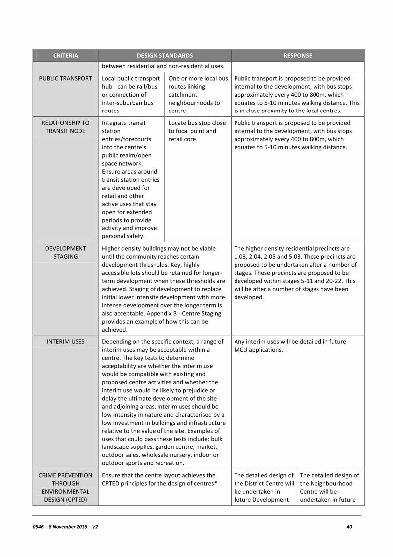
0546 – 8 November 2016 – V2 40
CRITERIA DESIGN STANDARDS RESPONSE
between residential and non-residential uses.
PUBLIC TRANSPORT Local public transport hub - can be rail/bus or connection of inter-suburban bus routes
One or more local bus routes linking catchment neighbourhoods to centre
Public transport is proposed to be provided internal to the development, with bus stops approximately every 400 to 800m, which equates to 5-10 minutes walking distance. This is in close proximity to the local centres.
RELATIONSHIP TO TRANSIT NODE
Integrate transit station entries/forecourts into the centre's public realm/open space network. Ensure areas around transit station entries are developed for retail and other active uses that stay open for extended periods to provide activity and improve personal safety.
Locate bus stop close to focal point and retail core.
Public transport is proposed to be provided internal to the development, with bus stops approximately every 400 to 800m, which equates to 5-10 minutes walking distance.
DEVELOPMENT STAGING
Higher density buildings may not be viable until the community reaches certain development thresholds. Key, highly accessible lots should be retained for longer-term development when these thresholds are achieved. Staging of development to replace initial lower intensity development with more intense development over the longer term is also acceptable. Appendix B - Centre Staging provides an example of how this can be achieved.
The higher density residential precincts are 1.03, 2.04, 2.05 and 5.03. These precincts are proposed to be undertaken after a number of stages. These precincts are proposed to be developed within stages 5-11 and 20-22. This will be after a number of stages have been developed.
INTERIM USES Depending on the specific context, a range of interim uses may be acceptable within a centre. The key tests to determine acceptability are whether the interim use would be compatible with existing and proposed centre activities and whether the interim use would be likely to prejudice or delay the ultimate development of the site and adjoining areas. Interim uses should be low intensity in nature and characterised by a low investment in buildings and infrastructure relative to the value of the site. Examples of uses that could pass these tests include: bulk landscape supplies, garden centre, market, outdoor sales, wholesale nursery, indoor or outdoor sports and recreation.
Any interim uses will be detailed in future MCU applications.
CRIME PREVENTION THROUGH
ENVIRONMENTAL DESIGN (CPTED)
Ensure that the centre layout achieves the CPTED principles for the design of centres*.
The detailed design of the District Centre will be undertaken in future Development
The detailed design of the Neighbourhood Centre will be undertaken in future

0546 – 8 November 2016 – V2 41
CRITERIA DESIGN STANDARDS RESPONSE
Applications. Development Applications.
7.6.5 Guideline no. 12 – Park planning and design (May 2015)
The Greenspace IMP attached as Appendix 10 addresses compliance with this guideline and indicates that the community greenspace network is typically aligned with the requirements and will be provided and embellished generally in accordance with EDQ Guideline 12.
7.6.6 Guideline no. 13 – Engineering standards (May 2015)
The relevant standards of EDQ Guideline 13 have been considered within the various technical assessments submitted with the Development Application.
7.6.7 Guideline no. 15 – Protection from flood and storm tide inundation (May 2015)
A Flood Investigation Report has been prepared to support to this application and addresses the requirements of Guideline 15.
7.6.8 Guideline no. 16 – Housing (January 2016)
Affordable housing will be provided through the future Development Applications in accordance with EDQ Guideline 16.
7.6.9 Guideline no. 17 – Remnant vegetation and koala habitat obligations in Greater Flagstone and Yarrabilba PDAs (May 2015)
This Guideline is addressed in the Ecological Assessment Report (Appendix 11), which indicates that “In addition to providing approximately 103 ha of vegetated and open space primarily for conservation outcomes within the project area, a preliminary calculation of the financial contributions mandated through Guideline 17 has been carried out using State Koala Bushland habitat mapping and the preliminary development area as shown on Plan 1 and Plan 4. The offset contribution will be approximately:
Clearing $2,250,000
Operational $1,650,000
Total $3,900,000
We note that the financial contribution will vary depending on the final clearing area and number of dwellings. Under Implementation Guideline 17 and Queensland Government Legislation, these funds must be paid to the State Government who, under legislative obligation, must deliver an offset for the affected matter (in this instance the Koala).”
7.6.10 Guideline no. 18 – Development interfaces (May 2015)
The design and development of the Context Plan and the Master Plan provides for larger lots along the northern boundary of the site. This will assist in providing a transition in density and a visual separation to the surrounding sites that border the subject site.

0546 – 8 November 2016 – V2 42
7.7 EDQ PRACTICE NOTES
Whilst the provisions of the Development Scheme is the main source of planning provisions for development within the Greater Flagstone PDA, there are a number of other EDQ Practice Notes that are applicable to this Development Application. An assessment against the relevant guidelines is provided below.
PRACTICE NOTE RESPONSE
1. Housing diversity Complies. The Master Plan provides for a range of lots, with lot frontages of between 7.5m and 18.4m, which will allow for a diverse range of housing. Detailed house design will be addressed in future Development Applications.
2. Footpath provision in residential subdivisions
Complies. Footpaths are provided on all major road cross sections (included in the Traffic Impact Assessment (Appendix 6). The verge for lower order streets (Urban Access (Major) and Urban Access will be variable.
3. Integrated residential development
N/A. Affordable housing products will be resolved in future Development Applications.
4. Integrating sustainable principles into residential subdivisions
N/A. Detailed environmental measures for the subdivision will be addressed in future ROL applications.
5. Lot mix and yield in integrated residential developments
Complies. The Master Plan allows for an appropriate street network to be delivered. The illustrative master plan (Appendix 12) shows one possible way that the development may meet these requirements.
6. Tree retention in residential subdivisions
Can comply. The detailed design of the residential allotments will be undertaken at a future stage, however it should be noted that approximately 147ha of the site is retained in park areas where tree retention will be a priority.
7. Designing for small lots N/A. Detailed environmental measures for the subdivision will be addressed in future ROL applications.
8. Calculation of monetary contribution in lieu of affordable housing product
N/A. Affordable housing product will be resolved in future Development Applications.
9. Context plans Complies. The Context Plan in Appendix 3 complies with the relevant practice note.
10. Plans of development N/A. A plan of development will be prepared for a future Development Application.
12. Rear lanes: design and development
N/A. Rear lanes may be provided in detailed design in future applications.
15. Implementation works Complies. Any applicable charges and offsets will be payable/calculated as part of any development approval.
16. Calculation of offsets for affordable and diverse housing
N/A. Affordable and diverse housing product will be resolved in future development applications.
17. Calculation of offsets for ecologically sustainable design
N/A. Ecologically sustainable design will be resolved in future development applications.
18. Calculating value uplift Complies. Any applicable charges will be payable as part of any development approval.

0546 – 8 November 2016 – V2 43
7.8 COMMONWEALTH LEGISLATION
7.8.1 Environmental Protection and Biodiversity Conservation Act 1999
On 10 June 2016, a Referral for the proposed development under the EPBC Act was made to the Commonwealth Department of the Environment and Energy (DoEE) for Controlled Action Assessment. On 13 July 2016, the project was deemed a Controlled Action requiring assessment by Preliminary Documentation.
On 3 August 2016, a request for additional documentation was provided by DoEE. Broadly the additional information requested revolves around the following three items:
1. Clarification and quantification of impacts on Koala habitat and details of the offset package to compensate for significant residual impacts on the habitat including analysis on how it meets the requirements of the EPBC Act Offsets Policy;
2. Further detail on potential impacts to the Grey-headed Flying-fox including the relative importance of the site as habitat and whether it provides a critical resource for the species; and
3. An assessment of the potential for significant impacts on the Greater Glider.
A response to the information request is currently being compiled in consultation with DoEE. Once the response is finalised it will undergo a public notification process. The EPBC referral is a completely separate application process to this Development Application and the above information is provided for information only.

0546 – 8 November 2016 – V2 44
8 CONCLUSION
PSA Consulting Australia (PSA) has prepared this planning report to support a Development Application on behalf of Celestino Pty Limited (Celestino), the Applicant, for the development of the Celestino Jimboomba Master Planned on land at 368-398 Bushman Drive and 72 Riverbend Boulevard, Jimboomba.
Specifically, the application seeks approval from Economic Development Queensland (EDQ) for the following aspects:
Preliminary Approval for Development Generally In Accordance with the Celestino Jimboomba Master Plan; and
Endorsement of a Context Plan.
This Development Application seeks to put in place an overarching, strategic framework that guides the development and delivery of the Celestino Jimboomba Master Planned Community. Future applications will be submitted to EDQ for any Material Change of Use (MCU) or Reconfiguring a Lot (ROL) in accordance with the Context Plan and Approved Master Plan. Plans of Development (PODs) will also be submitted with the relevant applications enabling consistent development is in accordance with the POD to progress as Exempt Development under the Development Scheme.
The Master Plan shows details of the long term development of the subject site, including:
Up to 7,000 lots to be subdivided over 27 stages, through future Reconfiguring a Lot (ROL) applications;
A Primary School to be developed by DETE;
A District and Neighbourhood Centre;
Recreational facilities, being a District Sports Park, Regional Recreation Park, multiple Pocket Parks and Community facilities.
The proposed development of the subject site complies with the relevant pieces of legislation, the Development Scheme and the applicable guidelines and practice notes. Accordingly, this application is recommended for approval by the EDQ, subject to reasonable and relevant conditions.

0546 – 8 November 2016 – V2
APPENDIX 1
TITLE SEARCHES

0546 – 8 November 2016 – V2
APPENDIX 2
PRE-LODGEMENT DISCUSSIONS

0546 – 8 November 2016 – V2
APPENDIX 3
CONTEXT PLAN

0546 – 8 November 2016 – V2
APPENDIX 4
MASTER PLAN

0546 – 8 November 2016 – V2
APPENDIX 5
FLOOD INVESTIGATION REPORT

0546 – 8 November 2016 – V2
APPENDIX 6
TRAFFIC IMPACT ASSESSMENT

0546 – 8 November 2016 – V2
APPENDIX 7
WATER AND WASTEWATER INFRASTRUCTURE MASTER PLAN

0546 – 8 November 2016 – V2
APPENDIX 8
CONCEPT STORMWATER MANAGEMENT PLAN

0546 – 8 November 2016 – V2
APPENDIX 9
ASSESSMENT AGAINST THE DEVELOPMENT SCHEME

0546 – 8 November 2016 – V2
APPENDIX 10
GREENSPACE INFRASTRUCTURE MANAGEMENT PLAN

0546 – 8 November 2016 – V2
APPENDIX 11
ECOLOGICAL ASSESSMENT REPORT

0546 – 8 November 2016 – V2
APPENDIX 12
ILLUSTRATIVE MASTER PLAN


![The magazine of - aleandteviot.org.uk · The magazine of ALE & TEVIOT UNITED CHURCH ... YOU will be a casualty. ... as all Strictly fans [!] will know, it takes two to tango. God](https://img.dokumen.tips/doc/110x75/5b377b5b7f8b9aad388e643a/the-magazine-of-the-magazine-of-ale-teviot-united-church-you-will-be.jpg)