Embed Size (px)
Citation preview

TheMonth’s
The Kansas City Area Grotto
Volume 17Issue 7-8August 2003
Caves of theGuadalupe Mountainsphoto: massive stalagmites in Ogle Cave (photo by Richard Cindric)
this month’s focus

The Month’s Guano2
September 6, 2003 CRF Ozarks trip to Powder Mill CreekCave for surveying (wetsuit required).Note: rain will cancel this trip. For moreinformation, contact Doug Baker [email protected].
September 11, 2003 Monthly KCAG meeting: 7:00 p.m. in theMagg Conference Center at the cornerof Volker and Cherry (on the UMKCcampus).
October 3-5, 2003 Fall 2003 MVOR, hosted by the MSMSpelunkers at the Pulaski County-FortLeonard Wood Shriner’s Club nearWaynesville, MO. This is a large site thathas accommodated as many as 1,300people at previous events. There are hotshowers available on site and plenty ofwell-maintained gravel roads. The funstarts on Friday, and you must go homeon Sunday. Events include a bonfire, anMVOR business meeting, and a banquet.The banquet includes pig roast, grilledchicken, hot dogs, potato salad, coleslaw, baked beans, chips, and soda.Cave trips will be offered to RoubideuxCave (aka Indian, Kraft, Pike’s Peak,etc.). Additional cave trips will beannounced. Confirmed vendors includesHowie’s Harnesses, Inner MountainOutfitters, On Rope 1, Barnwood Bats,and Potter’s Mind. MVOR items for saleinclude guidebooks, T-Shirts, bottomlesssouvenir cups (you must be 21 or overand have an ID to use the cups). Formore information, see the MVOR websiteat www.mvor.org.
October 9, 2003 Monthly KCAG meeting: 7:00 p.m. in theMagg Conference Center at the cornerof Volker and Cherry (on the UMKCcampus).
EventsTable of ContentsHorizontal Caving in the Guadstrip report by Gary Johnson, photos by Mike McKinney and Gary Johnson
page 4
Vertical Caving in the Guadstrip report by Jeff Page, photos by Richard Cindric, Mike McKinney, and Jeff Page
page 12
Cave Tours at Carlsbad Caverns National ParkReport by Gary Johnson, photos by Mike McKinney, Richard Cindric, and David Foran
page 18Hiking the GuadsReport by Gary Johnson, photos by Gary Johnson and Mike McKinney
page 20
2003 NCRC Cave Rescue Operations andManagement Seminar at Washington Ranch inCarlsbad Caverns National Parktrip report and photos by Bill Gee
page 22
Trip reports tentatively scheduled for future issues of The Month’s GuanoRichard Cindric reports from Rumbling FallsCave in eastern Tennessee ... Jeff Page and GaryJohnson visit Powder Mill Creek Cave with HalBaker on a geology trip ... Gary Johnson reportson the major springs of the Current River ...Sam Clippinger leads a scout trip to Little ScottCave and Hamilton Cave ... Look for these tripreports and more in future issues of The Month’sGuano ... And if you’ve been caving, please shareyour experiences by submitting a trip report.
Soda straws inPowder Mill Creek Cave
(photo by Jeff Page).

The Month’s Guano 3
The Month’s GuanoAugust 2003, Vol. 17, Issue 7-8
The Month’s Guano is published onthe last Wednesday of the month.Twelve issues annually.
Submit articles to the co-editor by thelast Wednesday of the month.
Guano subscription rate for nonmem-bers: $6.00 annually. Electronic: FREE.
President: Jeff PageV.P./Treasurer: Richard CindricSecretary: Jeff AndrewsEditor: Gary JohnsonCo-Editor: Bryon Carmoney, 3512 N63rd Terrace, Kansas City, KS 66104Web Master: Sam Clippinger
E-Mail Addresses: Bryon Carmoney: [email protected];Jeff Page: [email protected]; Sam Clippinger: [email protected];and Jeff Andrews: [email protected]
The Kansas City Area Grotto is affili-ated with the National SpeleologicalSociety and the Missouri SpeleologicalSurvey. In addition, KCAG is aFounding Member of Missouri Caves &Karst Conservancy.
Meetings are held every secondWednesday at 7 p.m. at Magg Hall(behind Spencer Laboratories) on theUMKC campus, Volker Blvd. & Cherry,Kansas City, Missouri.
Annual Dues: $15 for Full Members(three caving trips with KCAG, nomi-nation, and vote of membershiprequired.)
NCRC Callout number – Emergencyuse only: Central Region (502) 564-7815. This number may be used forcave rescue emergencies in the statesof Illinois, Indiana, Iowa, Kentucky,Michigan, Missouri, Ohio andWisconsin.
The Grotto trip to New Mexico was a big treat for our club, which rarely ventures outside theOzarks on its outings. We have Richard and Jerry Cindric to thank for getting it going early this
year and making contact with the various agencies to assure a successful trip. It was a veryunfortunate turn of events when, early in the trip, we heard that Kansas City had been hit bydevastating tornado activity. Richard and Jerry soon learned that their father's home had beentotally destroyed. Their dad was okay, but Richard and Jerry felt they needed to be with him andleft after only two days of caving. We missed their company, their expertise, and their photo-graphic abilities the remainder of the week. That fact, along with the certainty that there aremany more caves to explore in the Guadalupe range, makes a return trip in the near future aworthy cause for KCAG.
Most of the caves in this region are on publicland. They are under the control of the NationalPark Service, the U.S. Forest Service, and theBureau of Land Management. Access to manycaves is possible, at least on a seasonal basis, butthere is advance work on cavers' part to bedone. Some caves require a local guide, whilemost are self guided. The people in charge wereresponsive and pleasant to work with. Our guideto Ogle Cave, Tom Bemis, and our guide to HellBelow Cave, Phyllis Boneau, certainly enhancedour caving experience.
We also need to thank Mike McKinnney for taking his RV and providing us a comfortable place togather, eat, sleep, and visit after a hard day in the back country. A trip like this is an invaluabletool for bonding among a group. We do many things together, but after spending an entireweek, as opposed to a weekend, we felt like we knew one another much better. Many cameaway with the feeling that we need more trips like this. To sum up, we saw a lot, learned a lot,and had a great time. I’d go again in a heartbeat. Enjoy the trip reports.
Cave softly and safely,
Jeff PageKCAG President
MessagePresident
AFrom
the
Stalagmites in CarlsbadCaverns (photo by Mike
McKinney).
The Month’s Guano4
trip report by Gary Johnsonphotos by Mike McKinney &
Gary Johnson
Horizonal CavingGuads
Horizonal CavingGuads
trip report by Gary Johnsonphotos by Mike McKinney &
Gary Johnson
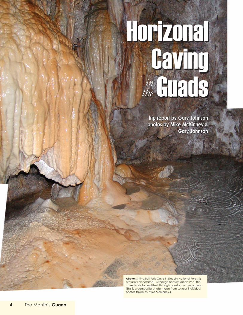
Above: Sitting Bull Falls Cave in Lincoln National Forest isprofusely decorated. Although heavily vandalized, thecave tends to heal itself through constant water action.(This is a composite photo made from several individualphotos taken by Mike McKinney.)
inthein
the

The Guadalupe Mountains comprise one of theworld’s great caving regions. Cavers from around theglobe make this their destination. Many millions of
years ago, these mountains were part of an ocean reef. Thickdeposits of limestone formed as the result of ocean sedi-ments and reef building. Then the oceans receded, leavingthe reef high and dry. Hydrogen sulfides associated withfields of oil and gas buried deep beneath the surfacemigrated upward and mixed with oxygen, forming a potentbrew — sulfuric acid — that subsequently dissolved hugepassages in the rock and left behind deposits of gypsum.The most famous caves in this area, Carlsbad Caverns andLechuguilla, are the results of this dissolution. TheGuadalupe Mountains contain many additional caves, andmany of these caves are quite impressive, containing hugepassageways and formations that sometimes equal (or evensurpass) the monster-sized formations in Carlsbad.
When Richard and Jerry Cindric announced they wouldbe leading a May 2003 caving trip to the GuadalupeMountains, I knew I had to go. I started buying books andreading everything I could get my hands on about theGuadalupe Mountains, their geology, and the caves that theyharbor. Stories from Stone (published by Carlsbad Caverns andGuadalupe Mountains Association) is essential reading fornovice geologists. It’s only 40 pages long. It covers most ofthe basics and describes several of the canyons. For readersdesiring more in-depth information about the caves, the NSSpublished a first-rate collection of articles — “The Caves ofthe Guadalupe Mountains” — in conjunction with a researchsymposium. In addition, Carol A. Hill’s Geology of CarlsbadCavern and Other Caves in the Guadalupe Mountains, New Mexicoand Texas provides a good dose of background informationabout the cave deposits and their mineralogy. (Hill is widelyconsidered the leading expert on the geology of these caves.)
Above: The eastern escarpment of the Guadalupe Mountains (photo byGary Johnson). Below: A massive fin of limestone named Elephant Rocklords over the mouth of Slaughter Canyon (photo by Gary Johnson).

The Month’s Guano6
Many of the caves in the Guadalupe Mountains requirevertical experience, and as of yet, I have only practiced alittle rappelling. And I’ve recently spent so much money oncaving and camping gear that spending more money to outfitmyself for vertical gear was out of the question. Luckily,however, Richard and Jerry had planned for a selection ofhorizontal caves, so regardless of my inexperience at vertical
caving, I could stillmake the trip.
The followingnotes describe eachof the caves visitedby the horizontalcaving group. Thehorizontal groupconsisted of SamClippinger, DavidForan, Pam Rader,Pedgie Heinz,Kathy Sumner, andme. Vertical caversRegan Youngmanand Barry Godsey
joined our group for Goat Cave, and Mike McKinney joinedus for Parks Ranch Cave and Sitting Bull Falls Cave.
Goat CaveGoat Cave is located up Slaughter Canyon. The entrance
to this magnificentcanyon is marked with alarge limestone fin onthe right bluff. This finis named “TheElephant.” As you driveon Hwy. 62 along theeastern escarpment ofthe GuadalupeMountains, it’s difficultto see Slaughter Canyon, but eventually a turnoff appearsand this turnoff leads you past the Black River (which istypically dry), past Washington Ranch (headquarters forNCRC training, see Bill Gee’s article), and past RattlesnakeSprings (a nice little oasis of vegetation). For the final couplemiles, the road becomes gravel, twisting around large patchesof sotol and prickly pear. At first sight, the mouth of thecanyon is awe inspiring. The bluffs rise sharply for nearly athousand feet on both sides and “The Elephant” lords overit all. A very impressive vista.
Two trails leavefrom the SlaughterCanyon trailhead.On the left, a steeptrail leads toSlaughter CanyonCave, climbing 500feet over thecourse of a halfmile. Rangers from
Carlsbad Caverns National Park conduct tours of this gatedcave. The other trail follows the bottom of the canyon floor,leading past lechuguilla, sotol, and torrey yucca — andnumerous large stream boulders. It heads up the canyon at agentle grade. This is the way to Goat Cave.
Several parts of the trail follow a dry, rocky stream bed.Is the streambed ever wet? Probably only during especiallyheavy rain. I saw little evidence of recent water activity.Many rock markers and cairns are placed in the stream bed— including rows of rocks across the stream bed — andthey’ve obviously been in place for a long time. Manydifferent types of plants line the canyon: century plant,lechuguilla, yucca, prickly pear, sotol, and others. However,you won’t find any trees on the canyon floor (another sign of
Above: The Slaughter Canyon trail follows a dry stream bed (photo byMike McKinney). Below to upper right: Yucca, cane cholla, and pricklypear cactus are plentiful in Slaughter Canyon (photos by Mike McKinney).

The Month’s Guano 7
little water activity). In contrast, in McKittrick Canyon inGuadalupe Mountains National Park, where a stream flowsall year long, the canyon is filled with sugar maples, pines,and other trees.
As you hike up Slaughter Canyon, the first evidence ofGoat Cave is its skylight, which appears as a small caveopening on a sheer bluff face. The skylight is visible from aquarter mile down thecanyon. At first, this seems tobe the only entrance. But asyou continue up the canyon,you can begin to see aroundthe rock fin and then the realentrance appears — a hugegaping borehole at least 50feet high and easily as muchwide. The climb up to theentrance from the creek bed is about 80 vertical feetaccording to the topo map, but it seemed almost twice thatto me. The first portion of the climb heads upa steep streambank. Loose rock and abundant prickly pear make this routesomewhat treacherous. (Sam sat on a prickly pear on the wayback down and ended up with several spines embedded inhis posterior.)
The entrance to Goat Cave is large, but the insidepassage is much larger. The ceiling reaches over 70 feet. The
skylight is near the entrance,just to the right. Lightstreams down through thisopening and illuminates thefar cave wall. The mainpassage contains several upsand downs, dictated by theamount of breakdown. Whenfirst entering the cave, wefound a whitish-grey cavefloor. The color was theresult of the thick layer ofgoat dung — old and now
powdery. Every step brought a puff of dust. As the othersstood at the cave entrance, I shouted a warning to themabout the dust, telling them to tread lightly. They looked atme like I was crazy, but soon enough they discovered what Imeant. Pedgie even wrapped a handkerchief around her noseand mouth. A smart move. Airborne dung can do nastythings to your lungs.
Sam and I tried the large side passage on the right. Itextended for about 150 feet. The cave’s largest formationsare in this passage. Two stalagmites were fairly good size,over 10 feet tall. This area also had many old, dry rimstone
dams. All the formationsin the cave were longdead. The water table haddropped considerably asgeologic uplift pushedthis old reef up severalhundred feet, leaving thecave completely dry. Alsoon the right, a littlefurther back in the cave,we found a small sidealcove with a goat (ordeer) skeleton. All thatremained was the ribcage and leg bones. Asomewhat eerie sight.
We continued all theway to the back of the cave, which is covered in guano.From the mound at the rear of the cave, we could still seelight from the cave entrance — testament to the hugedimensions of the cave entrance and the main passageway.Just before reaching the back, I entered a small alcove on theleft and discovered an impressive display of flowstone in apassage that extended for about 50 feet. But once again, theformations were long since dead.
The main feature of this cave is simply the scale of themain passage. This is one of the largest passages that I’ve
Above: Goat Cave’s entrance is a huge borehole in a limestone bluff.(photo by Gary Johnson). Upper left: Northern mockingbird (photo by MikeMcKinney). Left: Lechuguilla leaves contain dangerously sharp barbs (photoby Mike McKinney). Below: Large patches of prickly pear cactus callSlaughter Canyon home (photo by Mike McKinney).

The Month’s Guano8
ever seen in a wild cave. Goat Cave, however, is not a partic-ularly pretty cave. I don’t think I’d recommend anyone makethe hike up Slaughter Canyon just to see Goat Cave. Manypeople who visit this cave also visit Lake Cave, which isfurther up the canyon (up a near vertical trail). As its nameindicates, Lake Cave includes a subterranean lake, a very rarefeature in this area. Lake Cave is closed every summer formaternal colonies of bats. Unfortunately, we arrived in NewMexico only a few days after the visitation period had ended
Parks Ranch CaveParks Ranch is located on BLM land south of the
Guadalupe Mountains, where the land is largely flat andmarked by wide expanses of white rock. This rock isgypsum. The land is almost completely treeless, except for afew small scraggly trees that have taken root in the sinkholes that dot the land. The sink holes at Parks Ranch havebeen fenced off (to keep cattle from stumbling down?).Three primitive campsites adjoined the sinks, complete withfire rings. Scrub and cactus dot the surrounding land. Largejack rabbits dart from one shadow to the next.
We first explored the sink hole to the south. It lookedlike a drainage ditch with erosion cutting through what littletop soil there was and through the underlying rock. A pathcurled to the bottom of the sink and there we found a small
Above: The horizontal group at the main entrance to Parks Ranch Cave.This photo is a composite of several photos taken by Mike McKinney.Below: Sam Clippinger, Pam Rader, andDavid Foran inspect the caveentry log at Parks Ranch Cave (photo by Mike McKinney).

The Month’s Guano 9
opening — no more than two feet in diameter. Sam crawled infirst and his report didn’t bode well: he described a crawl withno let up in sight. If this was what Parks Ranch Cave was goingto be like, I began to doubt that I really wanted to visit it. Iexited this sink and went to investigate the sink hole to thenorth. Here I found two passages stacked on top of each other.I investigated the bottom passage and found a very easy tonegotiate five-foot-high tunnel. So I ran back to the south sinkand told the others what I’d found. They readily exited the sinkand followed me.
Kathy investigated the upper passage and reported there wasplenty of head room. David Foran followed and found the caveregister, labeled “main entrance.” So we’d found the rightpassage. Now, I’m not even going to attempt to describe thepassages in the order that we encountered them. The cave allsort of blends together in my mind. While areas of the cave aresomewhat pretty, much of the cave looks identical. The wallshave been scoured by floodwater. (You’re not supposed to goanywhere near this cave if it’s supposed to rain.) The cavepassage headed toward Chosa Draw to the east. The cave wallswere clearly carved by water action, the bends in the cave wereserpentine, and the walls were like a mini canyon passage.
Soon into the cave, Sam warned us that bats ahead of uswere putting up a fuss. They apparently didn’t like our presence.We gave the bats a few minutes while deciding how to continue.The BLM cave expert had said we might encounter migratorybats, but he had said nothing about maternal colonies or endan-gered bats. We decided to stay low in the passage and passbeneath the bats, but when we continued forward, the bats weregone. Parks Ranch has over 20 different entrances, so the batsmust have chosen to head for another section of the cave.
We encounteredfrequent cracks inthe cave walls andthese cracks wereoften filled withsmall gypsum crys-tals. The mainpassage neveropened up into anyrooms. The passagewidened a little bitin a couple places,
but for the most part, the passage was remarkably consistent inappearance, almost as if it were a man-made tunnel. So it didn’ttake long before some of the team members startedcomplaining of boredom. About a half-mile into the cave, webegan to encounter pools of water. I was thankful for thisvariety and pushed further. Some of the others were ready togive up on the cave. But Kathy and I, and later Pam, pushedforward and I’m glad we did. We found some of the strangest
rimstone dams that I’ve ever encountered. They looked like theywere made up of scales, like you might find on huge lizard. As Igingerly walked down the passage, I felt like I was walking onthe back of a dragon. If the floor had suddenly lurchedforward, I wouldn’t have been completely surprised. Othersections of the floor almost looked polished. Pam said theseareas looked like mahogany. I suspect the dark color may havebeen caused by pollution. Every now and then we’d get a faintwhiff of sulfur or a rotten egg. Pam hunted down MikeMcKinney and told him what we’d found and urged him to takesome pictures. He brought his camera, and then he and Ifollowed the descending passage until the water started to getabout knee high. After he took several photos, we headed outof the cave the same way that we came in.
Parks Ranch Cave is heavily used for cave rescue training.See Bill Gee’s article about NCRC training for more aboutParks Ranch Cave.
Sitting Bull Falls Cave This cave was one of the real surprises of this trip. I’d heard
the Sitting Bull Falls area was beautiful, but I didn’t know whatto expect of this cave. I’d heard it had been vandalized exten-sively, but I had also heard that constant water activity had
Above: Pam Rader in a typical passage of Parks Ranch Cave (photo byMike McKinney). Below left: Unidentified plant near Parks Ranch Cave(photo by Mike McKinney).

The Month’s Guano10
provided a relatively swift mechanism by which the cave healeditself. However, the proximity of the cave to the paved pathwaysat Sitting Bull Falls undoubtedly keeps the cave in constant peril.An onsite ranger likely helps reduce some of this threat. Thisentire area is absolutely gorgeous. A spring stream sends waterover a bluff, spilling into the canyon below. The constant flow ofwater has left the canyon verdant. The surrounding hills andbluffs are a forbidding reddish-brown. But the canyon is filledwith vegetation and pools, a surprising area in this desert-likelocale.
Sam and I located the cave and led the way in. The entranceis somewhat dangerous, with a constant flow of water keepingthe trail wet. But the rocks aren’t particularly slippery when wet— unlike Missouri dolomite. In fact, the traction underneath thefalls and up to the cave mouth was fairly good. Stairs had beencarved into the slope. Maybe at one time, this was a commercialcave. Or maybe during an earlier time in the Lincoln NationalForest’s history, access was encouraged. Just inches inside thecave, visitors are in for some amazing sights, which include cavepearls, deep greenish pools, walls covered with flowstone, andstalactites. This is quite possibly the most profusely decoratedcave — per square foot — that I’ve ever seen. Some vandalism
is fairly obvious: several stalagmites and stalactites are broken.However, not all of the broken formations may be the result ofvandalism. Several decades ago, during an especially cold winter,the cave froze up with ice. The added weight caused the fronthalf of the cave to collapse. The results are quite clear to anyonewho takes a few seconds to inspect the bluff face: it’s markedwith remnants of flowstone, canopies, and stalactites. Theseexposed formations have undergone extensive weathering, butthey are easily identifiable as flowstone. The shapes immediatelygive them away. Unlike the smooth bluff face that lines much ofthe canyon, the bluff face near the cave is marked by torturouscontortions. These contortions are the remnants of the fronthalf of the cave, along with the breakdown blocks that now layamong the pools andvegetation at the base ofthe bluff.
Moss covers theformations in the cave’smouth. Only inchesinside the mouth, a poolof cave pearls emergeson the left. These arerelatively small pearls, butthey are so plentiful thatthey cover the floor like
Above: Jeff Page stands beneath Sitting Bull Falls (photo by MikeMcKinney). Right: A large column from Sitting Bull Falls Cave (photo byMike McKinney). Below right: Cave pearls from Sitting Bull Falls Cave(photo by Mike McKinney).

The Month’s Guano 11
sand. All the walls are covered with flowstone. On the right adeep pool extends back for at least 50 feet. It possibly goesunder the cave wall to the west, maybe even leading to othersections of the cave. Everyone who entered this cave was quiteimpressed. This is arguably the prettiest area that we visitedduring the entire trip.
Cottonwood CaveWe arrived at our campsite in Lincoln National Forest late
Tuesday afternoon, so we had to rush to find Cottonwood Cave.Unfortunately, however, I wasn’t aware that during our drive to
the campsite we had already passed the turnoff for GuadalupeRidge. So when the horizontal cavers piled into my truck and wetook off to look for the cave, I continued further down DarkCanyon — when I should have backtracked a quarter mile. As aresult we wasted some precious time heading down the canyonroad to the northeast. By the time we figured this out, we hadalready endured a half hour of bouncing down rocky roads. Asa result, Kathy decided to drop out of the cave trip so that Sam(who was uncomfortable riding sideways in one of the smallseats in my truck’s extended cab) could move to the front seat.But once we finally found the road leading toward the ridge, Itook that route and we began the rather steep climb.
We had originally arranged for Ransom Turner, theGuadalupe Ranger District’s cave expert, to serve as our guidefor Cottonwood Cave. A guide is required for access to thecave’s lower passages. But only days before our departure on thistrip, Mr. Turner told us he was required to attend a trainingsession on the same day as our trip. So he had to cancel. Thatmeant we would only be able to explore the cave’s upper entryrooms.
By the time we parked and began the short trek to the cave,it was dark. The step log helped lead us down the trail and tothe cave mouth (although we questioned the step counts). As wetook the final turn and headed toward the cave mouth, wefound a large black void to the left. We couldn’t tell how far itdropped off. (On the following day when I returned to theridge, I discovered one of the
Above: Sitting Bull Falls (photo by Mike McKinney). Right: Speleothemsdrape the walls above a deep, clear pool in Sitting Bull Falls Cave. Thiscomposite photo is made up of several photos taken by Mike McKinney.Below: Pam Rader stands at the entrance of Sitting Bull Fals Cave (photoby Mike McKinney).
CONTINUED ON PAGE 30

VerticalCaving
in theGuads
VerticalCaving
in theGuads
trip report byJeff Page
photos byRichard Cindric, Mike
McKinney, & Jeff Page
Photo: A massive column from Ogle Cave(photo by Richard Cindric).

The Month’s Guano 13
Sunday, May 4 Carlsbad Caverns • Slaughter Canyon • Christmas Tree Cave
We started our day with a whirlwind tour ofCarlsbad Caverns. It was a shame we didn’t have timeto spend the entire day in that magical place, but wehad an ambitious schedule to pursue in the wild cavesof New Mexico and were eager to get started. Bothvertical and horizontal cave groups drove to the trail-head of Slaughter Canyon and hiked the dry streambedtogether until we reached the spot where the horizontalcave group would go on to Goat Cave and the verticalgroup would hike to Christmas Tree. Enroute, Mikesuffered a foot injury in the stream bed but kept goingin spite of the pain. Christmas Tree was not far fromthe trail split, but it seemed to be straight up. We werefortunate that it wasn’t in the summer because the daywas hot enough. This cave would establish the patternfor the rest of the week, where getting to the caves wasmore difficult than getting in and out of them.
We followed the step log for about 0.4 mile and over400 feet of elevation gain to the entrance. ChristmasTree was the least difficult of the vertical caves wewould attempt, so it was a good one to start with. Wegot in by rappelling about 20 feet from the entrance toa large, firm area. We explored on foot from then on.The cave was not large or difficult, but it was nicelydecorated, with the Christmas Tree formation as thenamesake and centerpiece of the cave. Mike, Richard,and I took several photos and this activity extended thetime we spent in the cave. The trip would have beenvery short had it not been for that. We climbed outwith only the aid of a hand ascender, which was a bitmore difficult than I expected, but we managed justfine. The day was nearly over since we had added thistrip to our Carlsbad Caverns day. We took the long hikeback to the vehicles and headed back to camp
Monday, May 5Ogle Cave
We had a logistics problem to deal with on OgleCave. We had seven vertical cavers and our permitwould allow only six to enter Ogle. Mike’s foot was stillgiving him trouble, so he volunteered to stay back Heopted to join the horizontal group’s trip to ParksRanch. This would have been a hard decision to makeotherwise because Ogle was our cave trip with the
Top to bottom: All three of these photos were taken in Christmas Tree Caveby Richard Cindric. In the center of the top photo is the Christmas Treeformation.

The Month’s Guano14
highest expectations. We met Tom Bemis, NPS CaveSpecialist, who would serve as our guide. The Park Servicedoes not allow unguided tours in this cave.
The cave was located on the opposite side of SlaughterCanyon from Christmas Tree, but it was not quite as longof a hike to the trailhead. The climb up was a bit moredifficult than the day before. We had to stop several timesto catch our breath. We also carried more gear for thelonger drop and longer cave trip. Tom rigged the rope tosome heavy mining equipment located at the lip of the verylarge opening to the cave. The cave had been used formany years as a commercial guano mine and much of theold equipment was still to be found at or in the cave. Thesingle 180 foot drop into Ogle was not technically difficult.About half the distance was down a talus slope from thetop, then a short stop on a ledge, followed by a free dropto the bottom. The fall zone of the cave was quite large.There was a convenient cubby hole that would hold allclimbers safely until the last was down.
After stashing the climbing gear, we followed Tomdown a long, steep talus slope into the main body of the
cave, probably a 50 foot or better elevation loss from thedrop zone. A heavy steel cable from the mining operationlay to one side of the slope. We soon encountered thesights that made Ogle famous — a massive, basilica shapedchamber with formations that remind one of a giantredwood forest. The tallest known column (Bicentennial,106’) in the western hemisphere is found in Ogle.
In the middle of this chamber is a crude work benchdisplaying artifacts from the mining period. We signed theregister on the table. We observed a wall of guano leftover after the mine was abandoned. The guano, Tomreported, was over one million years old, having beendeposited by a long extinct species of bat. We proceededto the back of the chamber, which ended in a sheer wallwith much graffiti scribbling on it. High above wasanother opening to a passage which was considered a sepa-rate and off-limits cave. Now, at two thousand feet into thecave, we could still see fain light from the entrance shaft.We made our way back to the shaft and climbed out. We
Left: Barry Godsey rappels into Ogle Cave as Terry DeFraties, Jeff Page,and Regan Youngman wait their turns (photo by Mike McKinney). Above: A huge column awaits at the base of the entrance pit in OgleCave (photo by Richard Cindric).

The Month’s Guano 15
left with the notion that we wouldn’t see a more magnifi-cent cave the rest of the trip.
Tuesday, May 6Travel day • RV breakdown • Hidden Cave
The next day, we traveled to Lincoln National Forest,where we had more caves on our schedule. This includeda stopover at Sitting Bull Falls (see Gary’s trip report) anda break down of the RV. The latter wasn’t a big problem— just a failed bracket in the generator compartment thathad the generator skidding on the pavement. We set aboutrigging a chain to hold the unit in place when a man andwoman in a truck asked if we needed help. At first sayingno thanks, Terry noticed an arc welder in the bed of thetruck and quickly voiced his change of heart. The manwas a pipeline welder who had all the equipment to lift thegenerator back into place and weld the bracket to theframe. A great stroke of luck. We were back on the roadafter about an hour. We got to our camp a bit too late inthe day to go caving, but we did have Hidden Cave on ourschedule for that day. We made a vain attempt to find it at
Above: Barry “Shooting Gallery Duck” Godsey poses in this profuselydecorated section of Ogle Cave. Terry DeFraties looks on in the leftforeground while Jerry Cindric supplies the remote flash (photo byRichard Cindric). Below: Most speleothems in Ogle Cave are dry, butthis formation is an exception (photo by Richard Cindric).

The Month’s Guano16
sundown, then abandoned the effort. We knew we had anaggressive schedule and some caves might need to be leftfor another trip.
Wednesday, May 7Deep Cave
The story of our venture to Deep Cave is more about thetrip to the cave than the exploration of it. From our camp, itwas a 3.5 mile trip to Texas Camp on a rough gravel road.Texas Camp is the last spot where a normal vehicle couldhope to go. We had one Jeep and two mountain bikes totransport five people and gear 3.2 miles to the trailhead.Regan and Barry had brought the bikes. There was enoughroom in the Jeep for two people and the gear. That left methe option of riding on top of the gear or walking. Trying the
former option for only a couple of bone jarring minutes, Idecided walking was not all that bad. Regan let me ride herbike part of the way while she hiked or hitched a ride in in theJeep (she fit beter on top of the gear than I did). Once wemade it to the trailhead on top of Wild Cow Mesa, we hadanother mile to hike to Deep Cave. This was to be a 300 footdrop and the closest length of rope we had was 440. Needlessto say, it was a slow hike carrying the rope and gear. It wasalso a hot, dry day on a windy mesa. After about an hour ofhiking along the ridge, we began to doubt our directions to thecave. We saw an openingacross the canyon that wethought might be the cave,but we never seemed toget much closer to it. Webegan to worry about oursupply of water, which bynow seemed inadequate.We decided to turn backand retrace our steps backto the Jeep. Shortly there-after, we looked down theslope we were on and sawthe entrance to Deep Cave.We had overshot it on thetrip out. We went down tothe entrance and talked about what we should do. We reachedthe consensus that there wasn’t enough daylight left for all ofus to get in and out of the cave before dark, and we wouldprobably run dangerously short of water. Mike, Regan and Ichose not to go into the cave. Terry and Barry would do thetwo drops to the bottom, then return to the surface.
There were very few options for rigging points for the 150foot slope to get into the cave. A small tree would have to do.Terry satisfied himself that the tree would hold sufficiently.
Top: The vertical group searches for Deep Cave while impressive canyonwalls loom in the distance. This composite photo was formed from multiplephotos taken by Mike McKinney. Above: The entrance to Deep Cave(photo by Jeff Page). Left: Mike McKinney’s RV broke down on the road toLincoln National Forest, but a pipeline worker came to the rescue (photosby Jeff Page).

The Month’s Guano 17
Regan worked on her suntan, while Mike and I stayed out ofthe sun. Terry and Barry got into the cave and found a largerock to rig the long rope for the three hundred foot drop tothe bottom. Keeping their promise not to explore the cavefurther, they returned to the surface in good time, and after de-rigging, we were on our way back to camp. Our instinctsserved us well that day. By the time we got back to the Jeep,we were nearly out of water. We vowed to return again tomake a proper trip into Deep Cave.
Thursday, May 8Hell Below Cave • Wrap-up
As with Ogle Cave, a guide was required for Hell BelowCave. Local caver Phyllis Boneau met us at our campgroundearly in the morning as we were recovering from the prior day’strip. She affirmed that today would not require any gruelingactivities. Hell Below was a short trip from Texas Camp,maybe 0.7 mile. Since Phyllis had a truck and we had Mike’sJeep, we got there in relative comfort. The cave was only 0.2mile from the trailhead. The entrance was a small, gatedopening in the side of the hill. This cave would prove to be
the most technically chal-lenging of all the caves wevisited this week. How thecave got its name is notentirely clear, but there isno doubt it just goes downand down. The entire cavewas a crevice systemconveniently filled withrubble and dirt in places tomake foot travel possible.The first drop, not far fromthe entrance, was onlyabout fifteen feet. It tookquite some time to rig.Then we were on to thesecond point, a fifty foot
rebelay from steel bolts permanently imbedded in the wall.That also took a great deal of time to rig. After all that wasnegotiated, we found ourselves in a wonderland of color andformations. Phyllis told us to rappel slowly in order to enjoythe beauty of this room. The bottom of the second dropplaced us on top of a slope which divided the cave into twoopposing passages.
Phyllis informed us that she was involved in restorationwork in the cave. The trails were all marked with flagging tape.
Taking the first slope(east?*), we climbed downto a point where we neededto rig a 20 foot hand line toget over one slick area. Thebottom of this held somefine formations includingcoral. We stopped forlunch here before exploringthe western half of thepassage Before going toofar, we had to rig our lastdrop of about 30 feet. Thispath led down to a finegypsum gallery which wouldbe as far as we would go inthe cave that day.
This cave proved to be specialin different ways than Ogle. Thechallenge of the rope work andthe diversity of Hell Below makeit hard to decide which cave wasmore enjoyable. This was last vertical cave we would visitduring the trip. We returned to Carlsbad Caverns and viewedthe bats flying out for their nightly foraging. There were someother caves on BLM land available for Friday, but the descrip-tions were uninspiring and we were a very tired bunch by thattime. Everyone felt the week had been a big success and it wastime to head for home.
*I have no map of the cave and the directions are guess work based on my topomap and my admittedly faulty memory
Above: Guide Phyllis Boneau onrope in Hell Below Cave (photoby Mike McKinney). Left: JeffPage on rope in Hell Below Cave(photo by Mike McKinney).Below: Delicate cave coralformations in Hell Below Cave(photo by Mike McKinney).

The Month’s Guano18
On the morning after the grotto membersarrived in New Mexico, we fittingly startedour week of caving by visiting Carlsbad
Caverns and taking the self-guided tours of theNatural Entrance and the Big Room. The NaturalEntrance trail starts at the Bat Amphitheater, wherethe cave mouth is over 150 feet across. Cave swal-lows dart across the entrance. The smell of guano ispungent. A concrete path winds through a series ofswitchbacks that descend to the floor of the mainroom, a descent of nearly 300 feet. The Bat Cavepassage extends to the east for over 1,600 feet, butno one is allowed to visit this section of the cave.It’s where the vast majority of the Carlsbad batshang out.
The main corridor path leads to the west. As first, it’s relativelylevel, but after you pass Devil’s Spring and Taffy Hill, the path heads
for more switchbacks as it descends to Devil’s Den and the IcebergRock. This is all huge passageway that averages around 200 feet wide,with a ceiling height that varies from a modest 50 feet to a humbling250 feet. Iceberg Rock is a huge breakdown block over 150 feet longthat nearly blocks the passage. Most of the formations in the maincorridor are dry. This is the oldest, highest section of the cave (nextto the Bat Cave), so little ground water now percolates through thewalls or ceiling of the main corridor. (The visitor center’s parking lothas made this situation worse, so plans are now being considered tomove the parking lot to a remote location.) The Natural Entrancetrail ends at the Lunch Room, which (as billboards along NewMexico highways are quick to point out) is located over 700 feetbelow the surface. From this point, you can either take an elevatorback to the surface or head for the Big Room trail. Here is whereyou’ll find most of the cave’s largest formations, such as the GiantDome, a massive column. It’s the tallest formation in the Big Roomat 60 feet. In addition to large formations, the Big Room also featuresominous drop offs, such as the Bottomless Pit and the Jumping OffPlace. The latter looks over the Lower Cave, which passes nearly 100feet below.
Later in the week, several of us took the King’s Palace Tour,
report by Gary Johnsonreport by Gary Johnson
Cave Tours atCarlsbad CavernsNational Park
Cave Tours atCarlsbad CavernsNational Park
Above: Massive formations occupy the Big Room of Carlsbad Caverns(photo by Mike McKinney).

The Month’s Guano 19
which visits some highly decorated rooms. These rooms were oncepart of the self-guided tour, but they had experienced considerabledamage from thoughtless visitors and now this section of the caveis only available by way of a ranger-guided tour. Sam, Dave, Pam,and I also took the Lower Cave tour. It involves negotiating threeladders and a relatively short section by rope. You get to see largebeds of cave pearls and profuse displays of soda straws. On myfinal day at Carlsbad Caverns National Park, I also took the LeftHand Tunnel Tour. This ranger-guided tour equips each visitorwith a candle lantern. So this tour has a bit of the old-time flavor.As described by the tour guide, the Left Hand Tunnel was used asa garage for many years. Rock from the elevator shafts was storedhere. In addition, dirt from the tunnel has been removed for use inleveling the cave’s paved trails. The first half of the Left HandTunnel is rather bland. It has been impacted significantly bycontact with man. But near the end, the formations become morenumerous and resemble the whitish grey formations of the LowerCave. Far down the Left Hand Tunnel waits the Lake of theClouds, the lowest point in the Caverns, and home to a smallcolony of fringed myotis bats. But this area is well beyond thetour’s terminus.
In addition to the cave tours, we also attended an evening batflight. The bats swarmed out of the cave in a counter clockwiseswirl before soaring off to the southwest and eventually disap-pearing from vision. According to the tour guide for Left HandTunnel, bats also exit from the old Bat Cave shaft, which can beseen from the Nature Trail (a short distance from the amphithe-ater). This is why the Nature Trail is closed in the evenings.
I had originally reserved a spot in the Hall of the White Gianttour, which is supposed to be a real wild cave trip, with headlamps,knee pads, gloves, etc. It reportedly requires extensive crawling andsqueezing through tight passages. But I decided it was best to get ahead start back to Kansas City on Saturday, instead of trying to dothe entire drive in one day on Sunday. So I reluctantly cancelled myreservation for Hall of the White Giant. The park also offers wildcave trips to Spider Cave, which is nearby but not connected toCarlsbad Caverns. The Spider Cave tour was completely bookedfor our trip dates, so be sure to make your reservations early. BothSpider Cave and Hall of the White Giant tours fill up quickly.
In addition to the caves at Carlsbad Caverns, the NPS alsooffers guided tours of Slaughter Canyon Cave. This cave is twentymiles southwest of Carlsbad Caverns in a magnificent canyon witha large limestone fin on the right bluff, named “The Elephant.” Ivisited this cave on the morning of my first full day in theCarlsbad area, before the rest of the caving team arrived, so thiswas my first taste of Carlsbad. A steep trail leads to SlaughterCanyon Cave, climbing 500 feet over the course of a half mile.Not a bad morning hike, but I wouldn’t want to do that climb inthe afternoon in the summer. Thankfully a few shadows wait at theentrance, enough to shield most of the tour participants while therest of the party is still making the climb up the hill. A group ofGirl Scouts started immediately after me, so I had an extra incen-tive to keep going up the trail at a good pace — lest I get passed.That would that have been embarrassing to say the least. TheSlaughter Canyon Cave tours accommodate up to 25 people. Youhave to show up with a D cell flashlight. I brought along my head-lamp also. But the passages in Slaughter Canyon Cave were so largethat the headlamp didn’t really illuminate much. A D cell flashlightreally is a necessity, preferably a big three-D-cell Maglite or a
comparable model. A ranger named Steff served as our guide, anda young man named Domingo served as her backup. Steff hadbeen leading tours at Carlsbad for over 16 years and was wellfamiliar with the cave and its history. Slaughter Canyon Cavecontains some huge rooms and formations. Most notable is theChristmas Tree and the Clansman. Both of these formationsstarted as brownish flowstone, but then the primary deposit mate-rial suddenly shifted to white and the formations were subse-quently covered with a thick coating of white deposits. This gavethe Clansman a somewhat sinister appearance, as if it were ashrouded wraith of gargantuan size. The coating had just theopposite effect on the Christmas Tree. The deposits glittered liketinsel in the beams of the tour group’s flashlights. This is one ofthe prettiest formations that I’ve ever seen. For a short time, guanowas mined in this cave, until the mining company discovered thatground water had leeched most of the beneficial minerals andnutrients out of the guano, leaving low grade fertilizer that wasn’tmuch good for anything. So the mining operation went broke.Along the guano pit, Steff pointed out the tiny bones of innumer-able bats, which looked like cherry stems embedded in the guano.She also led us to the cave “museum” — a federally protectedtrash heap of historic importance that included beer cans, innertube parts, and flash bulbs. The trip through Slaughter CanyonCave heads down well-trod paths, but it’s still a fascinating journeyand definitely worthwhile for anyone interested in caves.
Above: The Bat Amphitheater at Carlsbad Caverns (photo by RichardCindric). Below: Switchbacks lead the way inside Carlsbad Caverns.Cave swallows have built nests in the numerous holes that pockmarkthe sides of the entrance shaft (photo by David Foran).

The Month’s Guano20
report by Gary Johnsonreport by Gary JohnsonH I K I N G T H E G U A D SH I K I N G T H E G U A D S
Many people come to Carlsbad Caverns NationalPark just to take the cave tours. However, thisarea also features several excellent wilderness
trails in Carlsbad Caverns National Park, Lincoln NationalForest, and Guadalupe Mountains National Park. I arriveda day before the rest of the caving team, and on that day,I headed for McKittrick Canyon in Guadalupe MountainsNational Park. I hiked the first 3.5 miles of this trail (7miles round trip). This is a marvelous canyon. A springruns through the bottom of the canyon and that keepsthe immediate arealush. The trail weavespast maple trees,Texas madrone trees(with their unusuallysmooth, reddishtrunks), ponderosapine, alligatorjuniper, sotol, torreyyucca, and manyother unique plants. In the fall, the canyon turns red fromthe numerous maple trees and attracts large numbers ofvisitors. The lower trail ends at “the grotto” — anexposed section of cave, profusely decorated but nowexposed to the elements and quicklydeteriorating.
Later in the week, I returned to Guadalupe Mountains
National Park with Kathy, Dave, and Sam, and we hikedDog Canyon on the west side of the park. This section ofthe park is fairly remote. It’s only accessible by way ofHwy. 137, which passes through Lincoln National Forestto the north and then dead ends in Dog Canyon. We tookthe Marcus Overlook trail, which climbs 1,000 feet inthree miles and leads to a saddle that looks out over theBrokeoff Mountains to the west. A constant 60 mphwind met us at this saddle. The wind helped keep the
temperature tolerable.Along the trail wenoted many largecentury plants thatwere preparing tobloom. They sent upwide fleshy stalks.Dog Canyon is notlush like McKittrrick
Canyon. It is a highland desert environment. (It got itsname from the prairie dogs that once numbered in themillions, but they have long since been exterminated.)Before heading up to Marcus Overlook, we visited a shortnature trail that describes the native plants. This was anexcellent introduction to the area’s vegetation and Istrongly recommend it.
Above: Sam Clippinger enjoys the view from Marcus Overlook. TheBrokeoff Mountains loom in the distance (photo by Gary Johnson). Below:Prickly pear cactus and an unidentified vine-like plant with orange flowers(both photos by Mike McKinney).

In addition to the two aforementioned trails, Dave,Pam, and I also hiked a small portion of the GuadalupeRidge Trail in Lincoln National Forest. After visitingBlack Cave, Dave inspected my topo map of the regionand noticed a short section of trail, about a half milelong, leading to “Guadalupe Mine.” So we parked downthe hill from the ranger lookout station and headed downthe Ridge Trail. The trail followed a wide, rocky path,which could likelybe followed by a4x4 vehicle. Alongthe way we notednumerous exam-ples of pisolites(ancient cave pearlscementedtogether). The trailled down to asaddle, with a shortspur heading north.We followed thespur and it leddirectly to themine. Light fencingdiscouraged entryinto the mine pits.We could see theremnants of a ladder system in the larger of the two pits.We discovered plentiful samples of a rust-colored rocklying in fragments around the pit entrances. We conjec-tured that the rock was likely iron ore (possibly hematite).
I also hiked about half of the Old Guano Trail, whichleads directly from the campground at Whites City to theBat Amphitheater at Carlsbad Caverns. The route leadsover a very rocky path. For the most part, you’re walkingdirectly on bedrock. There is little if any soil. The path is
surrounded by sotol, lechuguilla, torrey yucca, and pricklypear. The trail provides some impressive vistas to thesouth across the gypsum flats. Along this trail near theBat Amphitheater, you’ll find the old Bat Cave entrancepit, which is surrounded by a high wire fence. The pit isrelatively small, only about 15 feet across. But it is stillopen to the cave below, and bats reportedly use theentrance for their nighttime flights (in much smaller
numbers than thosethat use the cave’snatural entrance).The smell of guanosurrounds the area.To the south of thetrail’s terminus at theBat Amphitheater,you can continuewith the NatureTrail, which is ashort but informa-tive journey throughthe desert vegeta-tion. Many signsalong the way iden-tify the plant species.This trail serves as agood, quick primer
on the native vegetation.Many additional hiking trails await ambitious visitors,
including Rattlesnake Canyon Trail and Yucca CanyonTrail in Carlsbad Caverns NP, Last Chance Canyon Trailin. Lincoln National Forest, and numerous trails that startat the Pine Springs Trailhead in Guadalupe MountainsNational Park. To hike all the trails would take severalweeks.
Above: Several examples of desert life (all four photos by Mike McKinney).Below: This view from the Guadalupe Ridge Trail shows the steep walls ofBlack River Canyon in the distance. A forest fire scarred the valley in theforeground (photo by Gary Johnson).

Day One, Thursday • June 19On the road
I packed the camper Wednesday night and was on the road at5:20 a.m. Thursday morning. 709 miles later, around 6 p.m., Icamped at Lubbock RV Resort. This is not a good park. Thepark hosts a lot of seasonals, and it is very close to the highwayand the airport. I was rained on heavily while going aroundAmarillo. There was more rain overnight, maybe 1/4 inch.
Day Two, Friday • June 20Arrival • Washington Ranch • Guadalupe Mountains National Park •Guadalupe Peak Trail
I left Lubbock at 7 a.m. Central time and arrived at the NCRCsite shortly after 10am Mountain time. The trip was about 210miles. I walked around a bit, found a place to park the camper,and set up camp. Most of the instructors were already there.
The NCRC site was at Washington Ranch, a private facilitynext to Rattlesnake Springs. It has a swimming pond (which wasempty), housing for up to 120 persons dormitory-style, kitchenand meeting facilities, and an obstacle course. Unlike the generalarea, there are a lot of trees at Washington Ranch, including manycottonwoods. I parked between two very tall trees, one on the eastside and one on the west. I had the camper in shade while thesolar panel was in sun most of the day.
After lunch I drove to Guadalupe Mountains National Parkand hiked up the Guadalupe Peak trail. This trail is 4.5 miles long
and gains 3,000 feet of elevation. I left the trailhead at 12:40 pm.The trip to the top took about two and a half hours. I spent halfan hour taking pictures, reading register entries, and writing myown entry. The trip down took about two hours. I drove back tothe NCRC site, had dinner, worked on this report, and took ashower.
The Guadalupe Peak hike is very strenuous. The trail is wellmarked but runs in limestone almost all the way. It’s like walkingon cave blasting rubble. The trail is so rough the park will not lethorses on it. Most animals could not negotiate this trail. At timesthe cliff face on one sideis 200 feet straight upand the other side — 4feet away — drops 200feet straight down.About half the elevationgain is in the first mile.
Once you get to thetop, the view is stupen-dous. Guadalupe Peak isthe highest patch of dirtfor hundreds of miles. Isaw three thunderstormsin the plains and couldhear thunder from twoof them. A plane flewby ... below me!
The Month’s Guano22
2003 NCRCCave Rescue Operations andManagementSeminarat Washington Ranch inCarlsbad Caverns National Parkreport and photos by Bill Gee Above: Level 3 students practice pickoffs during NCRC training sessions at
Washington Ranch. Below right: Bill Gee’s campsite at WashingtonRanch (photos by Bill Gee).

The Month’s Guano 23
The last time I hiked up Guadalupe Peak I had a blowout onmy right boot while coming back down. That time I took longercoming down than going up. No such adventures this time. I didget a good bruise under the ball of my left big toe and a big blisteron my right big toe. Fortunately, neither bothered me during theweek. The bruise went away in a couple of days and the blisterwas not a problem in my caving boots. I also had some soremuscles.
Day Three, Saturday • June 21Washington Ranch • Vertical Gear
In the morning, I registered into the seminar, then took mycamera and walked around the site taking pictures of most every-thing. Camp Washington Ranch is an oasis in the middle of thedesert. Besides the swimming pond, there are two other ponds onthe grounds. The upper pond is fed from Rattlesnake Springs.There is a small canal running from the upper pond to the lowerpond over a distance of two or three hundred feet. The lowerpond can be drained into the dry bed of the Black River.
The first meal served on the meal plan was lunch. Everyonemet at the dining hall where we were served in a lunch line. Thedining hall has a kitchen on one end, seating area in the middle,and offices and restrooms on the other end. There are doorsexiting on both sides. It has room for perhaps 150 people if theyare very good friends. There was no air conditioning, only acouple of swamp coolers that could not keep up. As a classroom,it left a lot to be desired. The main problem was acoustics. Theecho was very bad and there was no sound system.
After lunch the program began. Dave Ashburn got up andstarted things off. Everyone went around introducing themselvesand saying where they are from. There were people from all overthe United States, plus a couple of guys from Puerto Rico, onefrom Canada, and one from New Zealand!. Both coasts wererepresented. One girl was from New York City, not exactly a hot-bed of caving.
The first program was on Leadership/Followership. Thisemphasized the elements of being a good leader and a goodmember of a team. Everyone got to participate in a decision.Once a decision was made, everyone either got on board or gotout regardless of whether they agreed.
Late afternoon brought the first-day check-in requirements.For Level 1 students, that basically means gear check followed by ademonstration of basic rope skills. I had no problem goingthrough equipment check. Then I asked if my vertical rig wassuitable. The requirement is for two gripping attachments abovethe waist. My rope walker rig has a QAS tied to the seat harness.The other gripping attachment is the knee ascender which is teth-ered to the seat harness. The instructor doing the checking saidthere was no problem: this was an acceptable rig.
Once I got out to the rope course (a quarter mile hike!), theinstructor there turned me away, saying the tether was NOT suffi-
cient. I was peeved, to say the least. I walked back to the equip-ment check-in area and got hold of “Lurch”, one of the instruc-tors. He got John Punches and Dave Ashburn to take a look. Allthree confirmed that in a double-bungee system like mine, thetethered knee ascender counts as the second gripping point. Weall walked back out to the rope course. They made sure all theinstructors out there knew what was going on.
Had the decision been otherwise, there were several vendorsthere selling gear. I could easily have got a croll and tied it into myseat harness. The thing that got me upset was having instructorsgive different interpretations of the requirement.
Once this bit of excitement was over, the actual rope check-inwas anticlimactic. The course materials said I needed to be able toclimb 20 meters up, changover to rappel, and come back down.The actual climb was only 5 meters or so, just enough to see that Iknew how to make the rig work on a rope. Changeover and rappeldown was easy.
Top: The trail to the top of Guadalupe Peak crosses this bridge. The cliffdrops 150 feet below this bridge (photo by Bill Gee). Above: The viewfrom the top of Guadalupe Peak, looking southeast over the top of El Capitan. There were several thunderstorms out in the plains,which is why the view looks hazy (photo by Bill Gee).

The Month’s Guano24
I was amazed at how many of the people there did not have allthe right gear. Several light systems were turned away, as weresome home-made climbing rigs. A couple of people were using anall-Prussik system for climbing. That was OK as long as they hada handled QAS. Some people made quick trips to Wal-mart to getboots with blonde soles. Besides the business with my climbingrig, the only thing I came close to having trouble with was myhelmet. I’ve washed it often enough that the Snell certificationsticker inside it is gone. Fortunately there was another personthere with the exact same helmet, which had its Snell sticker intact.
Day Four, Sunday • June 22Ferno litters and SKEDs • Knots
This was the first full day of training sessions. In the morningwe had a couple of lectures in the dining hall. The first was onthe cave environment and was mostly aimed at the agency people.Some of them have never been in a cave before. I was surprisedto find out that at least one of the guys from the Carlsbad FireDepartment had never been in a cave, not even Carlsbad Caverns!
The course was completely sold out. We had just over 50Level 1 students, about 10 Level 2 students, about 20 in Level 3and about 20 going for Instructor Qualification. Add about 25instructors and we had a full crew.
Ken Laidlaw brought out his collection of climbing gear andwent through it. He showed many interesting and odd devicesthat are not used anymore. He explained the difference between aGibbs ascender and a Rescuscender. Lots of stuff was passedaround.
After Ken’s talk we were shown how to package a patient inboth a Ferno litter and a SKED. I had seen this before at theweekend orientation last September. Still, it was good to refreshthe skill.
After lunch we divided the Level 1 students into four groups.I was in group 3 with 12 other people. Each group took a Fernoand a SKED and practiced packaging a patient. After we haddone that several times, it was time for the obstacle course.
The instructors had laid out two obstacle courses on thegrounds of the Ranch. Groups 1 and 2 went to one course whilegroups 3 and 4 went to the other. Our course was laid out in asection of river bed. It had some ups and downs, rock crevices toget through, green cave formations to avoid and even a mudhole!They hooked up a sprinkler over one low point and let it run for afew hours. It made a nice mud hole 6 inches deep and 8 or 10 feetlong.
We started at opposite ends of the course. My group startedwith a SKED. We packaged up a patient, chose a team leader, andstarted off. We met the other team at the mudhole. Everyone wasglad to be there since the sprinklers were still going. It cooled usdown nicely! There was a lot of confusion over how to let thetwo groups pass each other.
After we got through, we chose another patient, another teamleader, and switched to the Ferno. The Ferno is much easier tohandle and more comfortable for the patient, but does not fitthrough some tight spots as well. We had an easier time ofpassing the other group. After debriefing and discussing, wecleaned gear and went to dinner.
Besides the checks done on the first day, everyone had acheckoff sheet of skills to demonstrate. Evenings were given overto doing the checkoffs. An area was set up outside the mainbuilding. Most of the instructors gathered to help. As eachstudent felt ready to get a checkoff, they approached an instructor.Each instructor was working with multiple students at a time,usually 3 to 5. When they were happy with how you did a skill, theinstructor would initial the item on the sheet. There were about40 items on the Level 1 checkoff sheet.
I spent Sunday evening learning knots and getting themchecked off. I knew about half the knots when I arrived but hadto learn the others on the fly. Sunday was also the day for litterand packaging checkoffs. For this, two students worked at a teamto package a third. This was a full package with all the vaporbarriers and wool blankets, so the victim got very hot. I did thisportion of the checkoff with Martin Roest. Martin is from NewZealand and is working for the summer at Jewel Cave. Martin andI did everything right and got our checkoff.
Above: A small part of the obstacle and rope course atWashington Ranch (photo by Bill Gee).

The Month’s Guano 25
Day Five, Monday • June 23Pickoff practice • Classes
The day began with some schedule changes. Due to the heat,the schedule was changed to allow most outdoor activities to takeplace in the morning or the evening. Another announcement wasmade. On Wednesday evening, Tom Beamis and Stan Allison,both of whom work at Carlsbad Caverns, would take the entiregroup on a nighttime lights-out tour of the Big Room and theKing’s Palace. Woo Hoo! The only rule was that each persongoing had to have all checkoffs done.
The first session of the day was a demonstration of the two-rope, conscious-patient pickoff. Two instructors demonstratedwhile we all watched. It only took them a few minutes. Theessential element of this pickoff is two tethers. One is longer thanthe other. The rescuer climbs up to the patient and slightly above.On the way past, the rescuer ties the longer tether between theirseat harness and the patient’s seat harness. They also unhook thefoot ascender if the patient is in a rope walker system.
After climbing slightly above the patient, the rescuer changesover to rappel and locks off their rack. This drops them a littlebit, close enough to tie in with the short tether, which must behooked directly to the eye of the rescuer’s rack. The next thing isto disconnect the patient from their rope. The main thing is toprovide a foot loop the patient can step up in, slacking their ascen-ders for disconnection. The patient then sits down and is now
hanging from the short tether and the rescuer’s rappel rack. Therescuer unlocks the rack and controls the descent of both people.
The pickoff demo was done about about 9 a.m. We all wentback to the dining hall and spent the entire day in classes. Topicswere medical considerations, hypothermia, anchors and haulsystems, and lower. The last two are used to raise or lower apatient in a litter using a rope. In several of these lectures, webroke into our small groups and practiced around the dining hall.We all set up tensioned back ties, several kinds of anchors, andseveral mechanical advantage systems.
After dinner, I went over to the rope course and did mypickoff. I really wish I could have had more practice on this. As itwas, I was being tested on the very first time I did it. Anotherstudent and I paired off. I was the first victim and Peter rescuedme. Peter did a pretty good job considering he was using a Frogsystem and had never seen a rope walker before. The sequence ofthings to detach is different. Peter also managed to climb too highabove me and had trouble changing over to rappel.
I did not have any tethers, so during a break I had made a pairof loops in webbing. I used a double Frost knot (which I learnedthe day before!) with unequal size loops. The idea was to attachthe middle loop to my seat harness and then use the other twoloops as the tethers. The instructor doing our checkoff approvedthe system before I started.
Climbing up, getting the first tether on my patient, andchanging to rappel was easy. Then I realized something ... I hadtied the Frost knot loops to my seat harness carabiner instead ofto my rack. In order to use my nice invention, I would have toopen the carabiner on which I was hanging. That was not goingto happen, so I improvised.
As it happened, Peter was still wearing all his gear includingboth of his tethers. I grabbed his short tether and used it. Thatbrought up the second problem. Rope walker systems don’t havea foot loop for the patient to use! Again I borrowed Peter’s gear.The only real problem we had was getting his QAS at the rightheight. It had to be low enough so he could sit on the short tetherwithout loading it but high enough so he could step up and let meunfasten his seat harness croll. We got the job done with aminimum of fuss.
It was dark by this time, so I took a shower and went to bed. Iwas less than half done with my checkoffs but figured I had seenCarlsbad before and could finish Wednesday while everyone elsewas gone.
Day Six, Tuesday • June 24Raising and lowering practice • Parks Ranch Cave
We spent the entire day on outdoors activities and cave activi-ties. In the morning, we all went to the cliffs to practice rigging,anchors, raising, and lowering. The cliffs are along Dark CanyonRoad about 6 miles west of US 62/180, about 30 minutes drivefrom the camp. Each team chose a location along the cliff. Werigged for a mainline, a belay line, and edge tenders. We loweredand raised several people who were just wearing their seat
Above: A patient packaged in the SKED (photo by Bill Gee).

The Month’s Guano26
harnesses. Then we put a patient in the Ferno and lowered themalong with a litter attendant. At the bottom, the patient switchedout, and we raised them back up. It was only a 30 foot drop, but itgave us much good experience. Even with a 3:1 haul system andfour beefy guys on the haul line, it is hard work pulling up thecliff !
We drove back to the camp for sack lunches, and then went toa cave to practice litter handling in a real environment. Groups 3and 4 went to Parks Ranch Cave. This cave is just across thehighway from the camp on BLM land, about a 15 minute drive.Most of that time is spent bouncing over a really rough road. Iwas very glad for my high-clearance truck. One of our other teammembers had taken himself and four others to the cliffs.However, his truck would not start when we headed for the cave,so they quick piled into my truck. I had a heck of a load withseven people and gear.
Park Ranch Cave system is a bunch of drains in a maze spreadout over several hundred acres. There are about four miles ofmapped passage on many levels. The cave is prone to flashflooding. There are no less than 28 known entrances. Two of theentrances are fenced off. Most of the cave is fairly small passageand is lined with gypsum. Since it floods often and forcefully,there are no formations. The area is apparently a popular partyspot.
As with the obstacle course, we started with the SKED. Wepackaged up a patient and moved into an entrance. The entrancewe used goes down a rocky channel in the rock at a pretty steepangle, then down a five-foot chimney into a belly crawl. Wemanaged to get the SKED into the crawl, but after about 10 feet,the shoulders both hung up. We could not move either forward orbackward. Our patient was getting a little nervous! We finallydecided to untie him and slide him forward in the passage. Thattook a little time but was no great trouble. The guys behind thenbrought the SKED through the tight spot. We repackaged ourpatient and carried on.
The entrance bellycrawl is only about 15 feet long, then thecave forks and opens up to a hands and knees crawlway ranging
from 3 to 5 feet wide.. The floor was dry and dusty with manyloose rocks laying around. The walls were mostly scallopedgypsum with no formations. The scallops here were fairly large, 3or 4 inches across.We took the left fork.
There were several sections where we had to do a lap pass.That gets a lot of people behind the litter where they cannot domuch good. The biggest problem we had in this tight passage wasgetting people from behind the litter to in front of it. It’s doublyhard trying to crawl over the patient without stepping on him.
We went several hundred feet, and then encountered the otherteam coming at us with a Ferno. The passage was up to about 4feet high though still very narrow. After considerable discussion,we decided to change to a new patient and team leader and swaplitters with the other team. Each team would continue in thedirection they were headed. This took close to an hour to decideand do.
Very quickly after changing to the Ferno, the passage openedup to standing height. This was not an improvement! It waskeyhole shaped, about a foot wide for the bottom three feet andthen opening up to about three feet wide. We wound up having tocarry the litter at shoulder height for the entire passage. After afew hard turns, we improvised a variation on the turtle carry.Instead of the turtles being under the litter on hands and knees,they were standing up with the litter on their shoulders. We gottwo people under the litter like this. Two more people attendedthe head and foot, guiding the litter and supporting a little of theweight.
We had one very difficult corner where we had to set the litterdown on one end, then sort of rock it around the corner. Therewas room for only two or three people to get hands on the litter,so they were working very hard. Once past this corner the restwas fairly easy. We had only one more adventure. We found apuddle of water about ankle deep which apparently contained cowmanure. It was ... ripe! It stank very badly and could not beavoided. You had to walk in it to get by. Yech!
We came out of the cave about 4 hours after going in. The biglesson to me was that too many people make things go slower. Asmaller team could have carried the litter much faster through thecave.
After dinner I went to do as many checkoffs as I could getdone. Things were hopping in the checkoff area, but much to mysurprise I got everything checked off. It was late, almost 10:30,when I finished. The thing that helped me most, I think, wasstanding around watching others do their checkoffs. By listeningto how they answered the questions, watching how they did thelitter rigging and listening to the instructors give corrections, Ilearned as much as I had in the lectures.
Since I had finished all my checkoffs, I decided to sign up forthe Carlsbad trip.
Left: Rescue training takes the participants to Park Ranch Cave. Aboutfive feet below the main passage entrance is another entrance thatgoes into the sewer passage (photo by Bill Gee).

The Month’s Guano 27
Day Seven, Wednesday • June 25Slaughter Canyon • Helen Cave • Carlsbad Caverns
In the morning we split up into our four subgroups. Each groupwent to a cave to practice making a haul system and pulling a patientup. Two of the teams went to Parks Ranch. The other two had aconsiderable hike in Slaughter Canyon. We were one of the teams thatgot to hike in. From the Slaughter Canyon trailhead, we went up theriverbed about ¾ of a mile, then started up the hill. We wound uptaking a wrong turn, so it was almost an hour before we got to HelenCave. The other team hiked up the Slaughter Canyon Cave trail to acave on the opposite side of the canyon from us.
Helen Cave is about a 30 or 40 foot pit with some passage at thebottom. We began by looking around for anchors. Eventually wefound several suitable rocks. It took us another hour to get a haul line,belay line, change of direction line, and an edge tender line rigged up.The change of direction had to happen twice. Fortunately, we hadbrought plenty of rope.
An instructor and two students rappelled into the cave. The restof us lowered the Ferno. One of the students became the patient andthe other was the litter attendent. They rigged in and we pulled themup. It took 15 minutes to get them over the edge because of the waythe ropes were rigged. The whole exercise took longer than wethought it would. It was 11:30 when we finished. Rather than runback, we all decided to bounce the pit just to say we had some cavetime.
The entrance pit goes down about 30 feet to a landing area, thengoes down another 20 or so on a slope. The pit and the area aroundthe slope is profusely decorated with flowstone and drapery forma-tions. They are completely dead and covered in dust. It’s all the colorof the desert outside. At the bottom the passage goes right about 25feet to an area with some nice stalactites. The left passage goesthrough a gate and on to the rest of the cave. We did not go throughthe gate even though it was unlocked.
After everyone was down, we immediately started climbing out.The first people out derigged all the lines except the climbing line.Everyone was back out by about 12:30. We hiked back to the cars inabout 30 minutes. It was much easier because we knew where wewere going and it was downhill. Even so, walking on the old streambed is hard work. Those rocks are all rounded off and slip very easilyunder your feet. You can’t get a good push off them.
We arrived back at the ranch an hour late, right at 2pm. The othertwo teams were also late, so they cut some of the lectures a little short.We only missed about 10 minutes of class time. The afternoon classeswere on hazerdous atmospheres, water problems, Incident CommandSystem, and psychological considerations. “Water Problems” meanscave flooding, not personal hydration.
In spite of the late start, the lectures were over early. I had enoughtime before dinner to get a shower. Dinner was early since we had toleave for the Carlsbad Caverns Visitor Center no later than about 6:50p.m.. I drove up and took another Level 1 student with me.
At the visitor center, we all kind of milled around for a while.Half the students had brought their helmets so they would not have tounmount their cave lights. I carried my cave light hanging over one
shoulder, with an extra light in my pack. We probably made many ofthe bat flight visitors curious about what we were doing.
Since it was only 30 minutes until sunset, we all decided to watchthe first part of the bat flight. Tom Beamis led us around to a sideroom at the back of the visitor center where everyone with helmetsdropped them off. We did not want too many questions from theother visitors.
We all trouped over and watched the beginning of the bat flight.About 8:15 p.m., just as it was really getting going, we headed back tothe visitor center. Tom ran one of the elevators to get us all down tothe Carlsbad Caverns lunchroom. It took five trips.
The lunchroom is a different place when the lights aren’t turnedon. The lights were out because there is an endangered species of batthat roosts in the Left-Hand Tunnel, near Lake of the Clouds. Whenthey leave, they fly right through the lunchroom. Artificial lightsdisturb their flight as does too much noise.
Eventually everyone was down and we set off for a tour of the BigRoom. After the first few hundred feet, Tom started turning on lights.We were far enough from the lunch room that the bats would not bebothered. The group stayed on tourist trails. We managed to spreadout far enough that the people in back were behind the turned-onlights. They wound up seeing the whole cave by helmet light.
After going around the Big Room with a rest stop at The Top ofThe Cross, we went on the King’s Palace tour. I have never see thispart of the cave before. It is somewhat downhill, perhaps 40 feet ofswitchbacks. Though smaller than the Big Room, it is just as deco-rated. There are a couple of places where it is obvious a tunnel hasbeen blasted through a rock. Again, Tom turned on lights as we went,but the group spread out enough that some used their helmet lightsfor the whole tour.
We gathered back at the elevators and rode up. I spent 15 minuteslooking at the stars while waiting for my passenger. If you’ve neverseen stars in the desert, you need to. We got back to the ranch just afew minutes before midnight.
Above: The entrance to Helen Cave (photo by Bill Gee).

The Month’s Guano28
Day Eight, Thursday • June 26Rescue practice
The morning was the last of the lectures. The topics were cavesearch techniques and public relations. After the lectures we talkedabout the walkthrough rules, then took a written test. The test was100 questions, all multiple choice.
In the afternoon, we split all students into three groups. Eachgroup included Level 1, 2, and 3 students. Each group went to adifferent cave to practice rescues from beginning to end. My groupwent south on highway 62/180 to a place about a mile north of theTexas border near the top of an escarpment. The cave was 30 feetfrom the highway, which made communication interesting.
I never did learn the name of this cave. It was not really a cave inthe proper sense. It was a narrow crack 40 or 50 feet deep where thetop was plugged by rock fall. We never really got into a dark zone.
We ran through four mock rescues. Each took a little less than anhour. In each case, a Level 3 student was chosen as IncidentCommander. Then a reporting party (one of the instructors) came upand made a report. The IC then directed the process of getting hastyteams into the cave, getting a comm team going, and basically directingthe rescue.
For the first scenario, I was on the first hasty team into the cave.We found our patient about 150 feet back in the cave. She washypothermic. The person in front of me was a paramedic and tookcare of the medical diagnosis. Since our patient was still conscious andable to respond, we decided to “feed and beat” her. Basically we putsome warm water and high calorie food in her, and then got her to herfeet to start walking. I had to guide every step for the first 20 or 30feet. Then others took over and she started walking better on her own.
The second scenario involved a tib/fib fracture. I was on one ofthe evac teams that helped carry the stretcher out of the cave. Thisone was made a little more interesting because the patient had aweapon in his pack and was combative and obnoxious.
For the third scenario we had one person in the cave whose lighthad gone out. That one was easy. The complicating factor was the
second patient. She was not in the main cave at all. We had to run asurface search. She was eventually found in a small hole above themain cave with a fractured femur. I was on the extraction team forthat one.
The last scenario was played to make us really think. The reportingparty was not concerned about his two friends, but he said he had notseen them for several hours. We did a cave search and found nothing.A surface search found nothing but footprints leading down the road.Eventually the two lost souls just wandered into the staging area andasked what was going on. They had been snoozing in their car thewhole time.
After debriefing and discussing, we all headed back for dinner.After dinner everyone met in the dining hall to talk about the rules andprocedures for the day-long mock rescue planned for Friday. TheLevel 2 and 3 students went and packed four equipment caches inpreparation for the mock.
Day Nine, Friday • June 27Mock rescue • Return to Parks Ranch Cave • Extraction
We had breakfast extra early, at 5:30 am. Right after breakfast wewere randomly assigned into four groups. A drawing was held todetermine the order in which the groups would respond to the event.I wound up on the first group.
The reporting party came in and gave his report in front of thewhole group. He and four other friends had been drinking the nightbefore. He heard them say something about going caving, then fellasleep. His friends were not back yet. He did not know what cavethey went to but could lead us to the one they often used.
As it turns out, the cave he led us to was Parks Ranch. We allarrived on the scene about 45 minutes after the initial report came in.We were very fortunate to have in our group Ken Halvey, who ownsan old ambulance. He has fixed up the ambulance as a command postfor search and rescue. His ambulance was immediately taken for thecommand post.
One of the Level 3 students took over as Incident Commander. Itwas not really a choice of the group. He just did it. No one had anyproblem with that as DJ turned out to be very good. When otherteams started to arrive, no one contested him for the position. DJremained for the entire incident. Another Level 3 student became theOperations guy. Two of the Level 1 students became the scribe andgeneral handy person. After a while, they were so integrated into thecommand team that they almost did not get any cave time at all.
I was appointed as Entrance Control. I got my chair, some paper,and an FRS radio and opened the log at 7:33 a.m. I was at an entrancewe eventually called “Central”. This area actually contains 7 or 8entrances, all of them surrounded by a big fence with a single gate.That gate was a natural checkpoint. I was only 75 feet from thecommand post and could easily hear everything that was going on.
The first order of business was to send out surface search teams.We also verified that the vehicles in the area belonged to the lostpersons. The surface search teams quickly found several clues,including a trail of beer bottles leading to a hole about 1,000 feet outto the west. Another surface team went about 2,000 feet east andfound a patient at the bottom of a hole.
Above: Going down the cliff with an empty Ferno. Later we had tohaul this back up with a patient and an attendant (photo by Bill Gee).
The Month’s Guano 29
The patient in the west hole had tried rappelling down but hadslipped and broke his tibia and wrist. This patient required a verticalextraction. Rigging and extraction teams were sent out with gear. Ittook them two hours, but they eventually got the hole rigged and thepatient out. The teams involved in this rescue reported they had waytoo much discussion. The leader of the rigging team finally had to getfirm. They also rigged the main anchor five times for no good reason.The instructors commented on this in the review. Every one of theanchors was a good one. They had no need to do it five times.
The patient in the east hole had a badly sprained ankle. Aftersplinting he was able to get out with assistance. By 10:00 a.m., we hadtwo of our four patients out of the cave.
Then the surprises hit. Surface teams turned up another entrancethat looked like it had been used. Search teams were sent in anddiscovered a patient who was hypothermic. Evac teams were sent witha litter. When this patient arrived on the surface, we discovered he wasnot one of the four missing people! Two people were still missing.
Hasty search teams were sent into several entrances of the cave. Atthis point some of the teams discovered why Park Ranch is nevervisited twice. Remember that smelly stinky puddle we found onTuesday? The whole lower section of the cave, hundreds of feet ofpassage, has 1 to 2 feet of that same kind of smelly sewage, stagnantwater in it. And in some places the passage is only a foot high with 6inches of water in it. Double yech!
Fortunately for me, I remained on Entrance Control until afterlunch. I did not have to go in any of the seriously smelly stuff.Several cavers were completely soaked in it. One team even pulledcomm wire through the muck.
The search teams found another patient without too much trouble.His lights had all failed but he was otherwise unhurt. He was loaned aspare light and walked out. The last patient was the hard one.
By 2:00 p.m., Incident Command thought the whole cave had beensearched. The searches had taken place over most of the morning, sothey were worried that we might have a moving party on our hands.IC decided to innundate the cave with search teams. No less than 10three-person teams were sent out to redo the search. The team I wason was told to poke into every nook and cranny in the first 150 feet ofthe 8 entrances in the central fence. We did that, getting in to themuck about knee deep in the process. Just when our time was up andwe were going back to report, we heard the patient had been found.
He was in a side-side passage about 1,000 feet in. He was comatose.We reported back to staging. As it turns out, there was a comm nodenear the patient, so IC ordered two of the search teams to merge andbecome an evac team.
The diagnosis was diabetic coma. That meant hurry was the orderof the day. To move things along, IC set up 6 more evac teams andstaged them along the exit route. I was on the second to last evacteam. Each team carried as fast as they could, burning out just aboutwhen they reached the next team and handed off the patient. In thismanner, it took about an hour to get the patient out of the cave.
After doing roll call and checking entrance logs, we packed every-thing up and headed back to the ranch. We got back about 5:00 p.m.Several dozen people went into Carlsbad for a real Mexican dinner,leaving the dining hall somewhat quieter for the rest of us.
Day Ten, Saturday • June 28Review • Amarillo • Finding a campground
The last day was only a half day. In the morning we all met andreviewed the mock rescue. All the team leads, the IncidentCommander, and many others gave brief talks about what they did andlearned. Dave Ashburn gave a high-level time line of events.
The reason we had not found the last patient was that some of thesearch teams said they had been through that passage when in fact theyhad not. We had two excellent large maps of the cave plus manyphotocopies. Every team that went in had a small map. Even sopeople got mixed up as to their location.
The instructors checked on the “patient” three times during theday. He was right where he was supposed to be. After lunch they evenswitched in another instructor! The point is that everyone needs to bereal careful about details. IC had bad information on which to makedecisions.
After the debriefing, we were given certificates and took grouppictures. I went back to the camper, finished loading, and was on theroad by 10:30 a.m.
I intended to drive to somewhere near Amarillo, about 6 hours orso, and find a place to camp. There is a campground about 10 milessouth of Amarillo that I had stayed at several years ago. It is only afew hundred feet from the Interstate and is very noisy, so I bypassed itand kept going. The first campground east of Amarillo was nothingmore than an overpriced patch of grass. No facilities, power oranything and they wanted $20 per night. I kept on going.
My Woodall’s directory showed a campground near Grimes, but itwas nowhere to be found. I kept on going and wound up about 5miles west of McLean, halfway from Amarillo to the Oklahomaborder. A gas station had a few pads on a gravel lot. $15 per night forelectric, water, and sewer hookups seemed reasonable; and it was after6 p.m., so I took it. Mistake!
The electric outlets were completely destroyed by repeated shortcircuits. I never tried the water. The sewer connection was clogged,and the Interstate was still only a few hundred feet away. I put inearplugs and got a decent night’s sleep. Several storms came throughovernight, including one with winds over 40 mph.
Had I kept going another 5 miles, I would have found an excellentcampground at McLean. Sigh ...
Day Eleven, Sunday • June 29The road home
I got up very early, had breakfast, packed up, and left. I was on theroad by 6:30 a.m. Very soon after I left, I ran into a rainstorm. Itrained for the next two hours, well into Oklahoma. The weathercleared and was clear until about Emporia. I got another dose of raincoming out of Emporia. I arrived home at 4:30 p.m.
Total driving distance was about 930 miles each way to WashingtonRanch. Pulling my trailer, I got about 15 miles per gallon.
Conclusion: I highly recommend everyone take this training if atall possible. You learn a lot about cave rescue. Perhaps as important,you learn how much you still don’t know! You meet people from allover the country, making an excellent chance to network with othergroups.

The Month’s Guano30
largest and most forbidding canyons in the entire area — Black RiverCanyon. With incredibly steep canyon walls, it resembles the GrandCanyon.) Even though we couldn’t enter the lower passages ofCottonwood, we nonetheless found the cave to be quite impressive.The entrance rooms are filled with huge formations. Many were largeenough they would have easily looked at home in Carlsbad Caverns.The formations were largely dry and dead —with the cave being located near the top of theridge (it must be one of the oldest caves in thearea), but the formations were still exception-ally impressive. In some respects, the cave wassimilar to Goat Cave. Both caves have hugepassageways and the entrance areas to bothcaves are covered with the powdery remains ofanimal dung. But whereas Goat Cave waslargely devoid of formations, Cottonwood wasa showcase of the largest formations that thehorizontal cavers encountered (outside ofCarlsbad Caverns). Some stalagmites wereeasily 40 feet in diameter and at least as muchin height. Some of these formations are evenvisible from the cave mouth. The back third ofthe entrance level is largely breakdown. Thecave floor slips down precipitously at the back,and this is where the gate for the lower level islocated. It’s a simple double-bar gate in ashallow metal shaft. From discussions withRansom Turner, this section of the cavehouses some fragile aragonite crystals andother rare formations. Denied access to thislevel, we inspected the tunnel at the very rearof the cave and found nice-sized dog-toothspar calcite crystals lining cracks in the lime-stone bedrock. We also inspected a lowerbreakdown room. It contained no formations. Dave was quite inter-ested in the tunnel at the back of the cave and spent several minutesexploring it. He even coaxed Sam to join him as they theorized aboutthe material used for graffiti on the tunnel wall. I was more interestedin the huge formations in the cave’s main passages and returned tospend additional time re-examining them. This is a magnificent cave.It might not contain formations as large as those in Ogle, but theCottonwood formations are very impressive nonetheless.
Black CaveWe set off from Texas Camp atop the Guadalupe Ridge with a
very detailed step log that contained at least 30 turns. But most ofthe turns simply followed the twists of the one clearly defined paththat led to Cave Canyon. So the cave was easy to find. The hike wasnearly two miles long. It led along ridge tops where plentiful junipersand pines restricted the vista. The trail was rocky and wide. Beforebeginning our hike to the cave entrance, we’d met briefly with PhyllisBoneau, who would be accompanying the vertical team to Hell BelowCave, and she said the dark residue on the walls of Black Cave wassoot — the result of fires in the cave. I was expecting the usualexplanation for black formations — manganese oxide. But subse-
quently I found an article by Carol A. Hill in which she said the blackresidue is indeed soot.
The formations in Black Cave weren’t as big as those inCottonwood. They were only a small fraction of the size. But theywere still impressive. One formation was quite unique: whereas mostformations involve a stalactite and a stalagmite, a formation in Black
Cave had three levels: 1) a soda straw drippingfrom the ceiling, 2) a mid-level stalagmite/stalac-tite that pointed up as well as down, and 3) below this midlevel formation, we found astalagmite.
The most interesting area of the cave for mewas a canyon passage. When we found thispassage, I approached it cautiously because therewas a drop off of 8 feet into the canyon and Iwasn’t sure I could get back out if I dropped in.But after spending some time analyzing the situa-tion and crawling along the ledge to the right, Ibecame rather confident that getting back outwouldn’t be a problem. The limestone walls werenothing like Missouri dolomite, which becomesquite slippery when wet. This New Mexico lime-stone had a ribbed, non-slip surface — just aboutthe easiest surface to climb across that I’ve everencountered. And Dave had a handline if weneeded it. So we were set. In addition, PhyllisBoneau had told us that there was a long passagebeyond the pools, so I was looking forward totesting my chimneying ability and investigatingthe canyon passage. Because the GuadalupeMountains have experienced much reduced rainlevels over the past several years, the water levelin the canyon passage was relatively low. Daveand I found only a few inches of water. Instead
of walking through the water, however, and possibly clouding thewater and trampling on any life, we decided to go ahead and chimneythe passage. The first part was quite easy. I could place one foot onone side and my other foot on the other side and pretty much walkright down the passage. But eventually the canyon sides got farenough apart that I had to place both feet on one wall and bothhands on the other and slowly move sideways down the passage.Once again, the ribbed surface of the limestone made foot tractionideal and chimneying wasn’t a problem. Dave followed and eventually
Above: While trekking to caves, we frequently encountered lIzards(photos by Mike McKinney). Below: David Foran looks into theentrance of Black Cave (photo by Gary Johnson).
Horizontal Caving in the Guads CONTINUED FROM PAGE 11

Sam also followed, while Pam and Kathy stayed back at the lip of thecanyon passage. All of us found the passage to be rather easy to nego-tiate. At the far side, I found a tiny squeeze between some rocks thatled to a continuation of the passage. This was maybe the tightestsqueeze I’ve ever attempted to negotiate. But once through the squeeze,the passage immediately opened up. I continued chimneying my way upthe side of the canyon while Sam and Dave watched below. I keptexpecting to reach a large passage, but before I knew it, I was looking ata dead end. Unlike Phyllis’ assertion that the passage continued for along way, we discovered only about 70 feet of passage beyond thewater. But it was a fun side trip nonetheless. We retraced our steps andcrawled back up and out of the canyon passage to join Kathy and Pamand explore the rest of the cave.
Side note: we had originally planned to also visit Little Beauty Cave.The Lincoln National Forest cave expert, Ransom Turner, haddescribed the cave as short, only about 200 feet long, but profuselydecorated. However, we didn’t receive a complete step log for LittleBeauty. The step log only contained directions to Texas Camp. I knewthe cave was at least a mile, maybe two, beyond Black Cave and downCave Canyon, but without an actual step log, we didn’t try to find thecave.
A few miscellaneous topicsAbout the drive to New Mexico: This is a murderous drive, particularly theseemingly endless stretch from Oklahoma City to Amarillo. I drove theentire route by myself and I don’t recommend that for anyone. It’shorribly monotonous and I had to fight off a couple of drowsy spells.And be sure to wear your seat belt in Texas. A state trooper — going in
the opposite direction (across a median even) — picked me out of thetraffic and tracked me down. As the trooper told me, “We take seat beatviolations seriously in Texas.” So consider yourself warned. (The fine:$100.) As you close in on the town of Carlsbad, New Mexico, youbegin to see the Guadalupe Mountains on the horizon. They run far tothe south where they immediately terminate at El Capitan in GuadalupeMountains National Park — a sheer vertical drop of several hundredfeet and an impressive sight on the horizon. In fact, it was so impres-sive, I made the split decision to head for Guadalupe MountainsNational Park, set up camp, and do some hiking. (The rest of the grottowouldn’t be arriving in New Mexico for a couple days yet.)
About White’s City: We spent most of our evenings at the White’s Citycampground. It’s located immediately outside the entrance to CarlsbadCaverns National Park. There are no campgrounds within the NationalPark. White’s City is the one and only campground for several miles. Sowe didn’t really have any options. The campground is somewhat rundown, but it served our purposes well. Grass cover was a bit sparse sothe best campsites were quickly gobbled up. The campground issurrounded by extremely thick patches of prickly pear and other flow-ering plants (in fact most of the photos of desert flowers in this issueof the Guano were actually taken beside the White’s City campground).I suspect this campground doesn’t really get busy until the summer.Then it’s likely a mad house, with a waterpark and knickknack shopsattracting hordes of families. But for most of our time at White’s City,we had the place to ourselves (except for the evening that a churchgroup set up camp and spent most of the night strumming songs andtrekking through the middle of our camp on their way to the restroom).A strange abandoned castle-like structure sits high on a hill to the northof White’s City. One evening, several of the curious donned their head-lamps and trekked up the hill to do a little exploring. White’s Cityincludes a filling station, a motel, a bar, a restaurant, a souvenir shop, asmall grocery store, and some sort of arcade/tourist trap. We also hadaccess to a swimming pool. This is one of the most expensive camp-grounds that I’ve ever encountered, though. It costs $20 per campsite.
The Month’s Guano 31
Above: White’s City campground is surrounded by pricky pear, yucca, andother desert vegetation (photo by Mike McKinney). Above right: From thewest edge of White’s City campground, a trail heads over a hill. This is theOld Guano Trail. It’s the route that early explorers took to the mouth ofCarlsbad Caverns (photo by Mike McKinney). Below left: This castle-likestructure sits on the hill to the north of White’s City campground (photo byMike McKinney). Below right: This profile of the Guadalupe Mountainsgreets visitors as they approach Carlsbad Caverns from the north. That’s ElCapitan at the left (photo by Mike McKinney).

The Month’s Guano32
About the wind: The Guadalupe Mountains have to be one of thewindiest places I’ve ever visited. Several members of the caving teamexperienced broken tent poles. Winds even claimed Barry and Regan’slarge shelter tent, which had previously seemed indestructible. I hadmy tent guyed out on all four corners and it withstood the wind, butlater I discovered one of the fiberglass pole sections had split (but afterapplying a little duct tape it was fine again). Winds at the White’s CityCampground were strong, but the strongest winds awaited us inLincoln National Forest. We set up camp in Dark Canyon to the northof the Guadalupe Ridge (about 1,000 vertical feet below Texas Campand the ranger lookout station). We shared the area with cattle andhorses. Here, winds ripped through camp, twisting tents and making itdifficult to sleep. Winds typically arrived in the middle of the night.Tremendous 60+ mph gusts that brought along dust and grit. The dustwas so fine that it worked its way into everything I owned. It wentright through the tent’s ventilation mesh and coated all the contents.But luckily the winds also made the New Mexico heat quite tolerable.During the days, we experienced temperatures in the mid 80s. But theconstant wind made the air seem much cooler. If you head to theGuadalupe Mountains, be sure your tent is sturdy and in good condi-tion. And by all means take an extra 10 minutes to guy down the tentcorners. We experienced drastic changes in the wind direction, so don’ttry to get away with guying down just one corner. Do all four. And it’sprobably a good idea to be carrying a repair kit for your tent poles.
About the drive home: Kansas gets a bad rap. People say it’s flat andboring. But on my return drive home from New Mexico, I foundKansas to be anything but flat and boring. Most of the highway fromNew Mexico to Kansas City is indeed dreadfully flat. The landsurrounding the highway in the Texas panhandle and westernOklahoma is brown and parched. This is mostly cattle country. Notmany farmers try to till this soil. Trees are few. Most ground cover issparse. But the closer I got to Kansas, the greener the land became.Trees became taller and thicker. North of Wichita, the land becameabsolutely verdant. Everything was green. And then the Flint Hills sentripples across the landscape, causing the highway to dip and curve. I’dnever seen Kansas like this, contrasted with its flat and dry neighborsto the south. It was nothing less than inviting and (dare I say it) beau-tiful. Kansas? Okay, it was still spring and the deadly summer heat hadnot yet parched the Kansas soil. But during early May 2003, Kansaslooked nothing like its critics say. It was a green carpet in contrast tothe rocky flatland to the south. Sometimes it takes a different perspec-tive to make you appreciate what you have, to appreciate the land thatyou call home.
Wrap-UpOverall, this was a great trip. We were in New Mexico for a full
week and saw many caves, but I feel like we only scratched the surface.Carlsbad Caverns alone can keep you busy for several days with all thetours that they offer, and the hiking trails in the National Park and inadjoining Lincoln National Forest could keep you busy for severalweeks.
Thanks go to Richard and Jerry Cindric for putting together thistrip. This was an incredible experience, and I’d eagerly go on anothertrip like this in the future.
Above: All photos by Mike McKinney, except the Carlsbad formation,which is by Richard Cindric.