Embed Size (px)
Citation preview
Causes and Perceptions of EnvironmentalChange in the Mangroves of Rufiji Delta,
Tanzania
Implications for Sustainable Livelihood and Conservation
Simon Mwansasu
Department of Physical GeographyStockholm University
Stockholm 2016
–
c© Simon Mwansasu, Stockholm University 2016Cover illustration: A river channel in the Rufiji Delta. Photo by Simon Mwansasu – 25thFebruary, 2014.ISBN: 978-91-7649-389-2ISSN: 1653-7211Type set with LATEX using Department of Physical Geography thesis templatePublished articles typeset by respective publishers, reprinted with permissionPrinted by: Holmbergs, Malmö, 2016Distributor: Department of Physical Geography, Stockholm University

Abstract
Mangroves are ecosystems with enormous ecological importance, supporting both terrestrial andmarine food webs. They provide ecosystem services (e.g. food, medicines, fuel, constructingmaterial) to communities near and far. Despite their importance, mangrove areas are facingnumerous threats. Based on neo-Malthusian narratives, population growth is an alleged maincause of mangrove degradation, especially in developing countries. This thesis investigates theRufiji Delta mangroves, from several perspectives including: recent history, present condition,use of land and other resources, as well as actual and potential impacts of government policiesand management on mangrove conservation and for the local communities. Of special interestis the examination of multiple, and often diverging, perceptions concerning these variables andprocesses. Both qualitative and quantitative methods have been used. Interviews were conductedwith relevant stakeholders. Analysis of census data (1957–2012), to ascertain population trendsin the Delta, spans the pre- and post-Ujamaa villagization programme. Old maps were scannedand geo-referenced in GIS to compare administrative units between successive censuses. Syn-thetic Aperture Radar (SAR) imagery, spanning from 1994 to 2010, was explored for analysis ofmangrove dynamics and stand structure. The analysis of population trends in the Delta revealeddecreasing population in the South Delta and a low population increase in the North Delta, incomparison with neighbouring non-delta areas. This is contrary to the assumption by govern-ment authorities that the Ujamaa villagization programme instigated migration to the Delta whichcaused mangrove degradation. Spatio-temporal changes in mangrove area and land use, observedand confirmed by SAR imagery and field control, is part of the highly dynamic eco-hydrologyand geomorphology of the delta ecosystem. While some areas have been converted to rice farms,other areas have gained in mangrove coverage. Overexploitation of mangroves occurs, primar-ily by external actors, and both local communities and representatives of government authoritiesascribe this to lack of financial and human resources to enforce current laws and regulations.Ever since the Rufiji mangrove forest was declared as a forest reserve in 1898, it has been a legalquagmire, with legally established village land within a state forest where human habitation isprohibited by law. This thesis explores management approaches that will embrace conservationwith sustainable development. That can only be achieved when local communities are legallyrecognized as inhabitants and important stakeholders in the conservation of the Delta. A con-servation approach that removes land tenure uncertainty among the local communities and takesinto consideration the dynamic nature of the Delta must be devised for the Rufiji mangroves.
Sammanfattning
Mangroveskogar är ekologiskt viktiga ekosystem som stödjer både landbaserade och marinanäringskedjor. De förser lokalsamhällen med ekosystemtjänster i form av t.ex. mat, läkemedel,bränsle och byggmaterial, och har en regional betydelse med avseende på vattenkvalitet ochsom erosionsskydd. Trots detta är mangroveområden utsatta för många hot, och enligt neo-malthusianska förklaringsmodeller är befolkningstillväxten den främsta orsaken till att man-groveskogar degraderas, särskilt i utvecklingsländer. I denna avhandling studeras mangroveskog-arna i Rufijiflodens delta, Tanzania, ur flera perspektiv. Här ingår nutidshistoria och förändringinom både ekologiska och sociala system, nuvarande status vad gäller utbredning och kvalitet,användning av mark och andra naturresurser, samt nuvarande och potentiella framtida effekterav nationell naturskyddspolicy och naturresursförvaltning på de lokala samhällena. Av särskiltintresse är att analysera de ofta divergerande uppfattningarna gällande dessa variabler och pro-cesser. Både kvalitativa och kvantitativa metoder har använts i denna tvärvetenskapliga ge-ografiska studie. Intervjuer genomfördes med berörda aktörer, såsom bybor och tjänstemän.Befolkningsstatistik analyserades i syfte att kvantifiera den demografiska utvecklingen i deltat,före och efter det så kallade Ujamaa villagization-programmet. Äldre kartor scannades ochgeorefererades i GIS för att möjliggöra jämförelser av befolkningsutveckling inom och mellanadministrativa områden. Satellitburen syntetisk aperturradar (Synthetic Aperture Radar, SAR)utforskades för en analys av mangroveskogens dynamik och beståndsstruktur under perioden1994–2010.
Analysen av befolkningsutvecklingen i Rufijideltat visade en minskande befolkning i densödra delen av deltat och en låg befolkningsökning i den norra delen, i jämförelse med närlig-gande områden utanför deltat. Detta strider mot statliga myndigheters antaganden att Ujamaavillagization-programmet under 1970-talet orsakade omfattande migration till deltat, vilket i sintur har antagits orsaka förluster av mangrove. Spatio-temporala förändringar i mangroveut-bredning och markanvändning, observerade och bekräftade av SAR-bilder och fältkontroll, ären del av den ekohydrologiska och geomorfologiska dynamiken i deltat. Medan vissa man-groveområden har exploaterats för risodling, har utbredningen av mangrove ökat i andra områ-den. Överexploatering av mangrove sker främst genom externa aktörer, och både lokalsamhällenoch företrädare för myndigheter menar att detta beror på otillräckliga ekonomiska och personellaresurser att genomdriva och övervaka att gällande lagar och förordningar efterlevs. Ända sedanmangroveskogen i Rufijideltat förklarades som ett skogsreservat vid sekelskiftet 1800–1900har förekomsten av lagligt etablerade byar inom reservatet utgjort ett rättsligt gungfly, efter-som bosättning inom skogsreservat samtidigt är förbjudet enligt lag. Denna avhandling under-söker förvaltningsmetoder med potential att kombinera naturskydd med en hållbar utveckling förlokalbefolkningen. Detta syfte kan bara uppnås om lokalsamhällen juridiskt erkänns som viktigaintressenter i bevarandet av deltats mangroveområden, vilket måste inkludera ett förvaltningssys-tem som upphäver osäkerheten gällande lokalbefolkningens markinnehav och som tar hänsyn tillRufijideltats dynamiska karaktär.

Causes and Perceptions of Environmental Change in the Mangroves of Rufiji Delta
Thesis content
This doctoral compilation dissertation consists of a summarising text and the V articleslisted below.
I Mwansasu, S., Westerberg, L.-O., Dahlberg, A. Landscape processes, resource useand conservation ideologies in the Rufiji Delta, Tanzania: An examination ofpopulation and degradation narratives. Manuscript.
II Mwansasu, S., Westerberg, L.-O., Dahlberg, A. The Rufiji Delta Mangroves – ForestReserve or Conservation Area? . Manuscript.
III Brown, I., Mwansasu, S., Westerberg, L.-O. Multi-decadal L-band SAR observa-tions of the Mangrove forests of the Rufiji Delta. Manuscript.
IV Brown, I., Mwansasu, S., Westerberg, L.-O. (2016). L-band Polarimetric TargetDecomposition of Mangroves of the Rufiji Delta, Tanzania). Remote Sensing, 8(2), (doi:10.3390/rs8020140)
V Mwansasu, S., Westerberg, L.-O. (2014). Biofuel potential and land availability:The case of Rufiji District, Tanzania. Journal of Ecology and the NaturalEnvironment, 6 (11), 389–397. (doi: 10.5897/JENE2014.0479).

Author contributions
The contributions from listed authors are divided as follows for each article.
I My contribution: I designed and conceived the study, led the fieldwork, and wrotethe earlier versions of the paper. I did all GIS work and population data analysis. Iwas responsible for creating and editing all the illustrations in the paper. I led thediscussions.Others’ contributions: L-OW and AD supervised the methodology, participated inthe inception of fieldwork, discussed results and conclusions, and co-edited the pa-per.
II My contribution: I designed and conceived the study, led the fieldwork, and wrotethe earlier versions of the paper. I was responsible for creating and editing all theillustrations in the paper. I led the discussions.Others’ contributions: L-OW and AD contributed to the study design, discussedresults and conclusions, and co-edited the paper..
III My contribution: I contributed to the design, discussion of the results and co-editingof the paper. I was responsible for field work.Others’ contributions: IB was the main author, processed the data, contributed tothe study design and results discussion. L-OW contributed to the study design andwriting.
IV My contribution: I contributed to the design, discussion of the results and co-editingof the paper. I was responsible for field work.Others’ contributions: IB was the main author, processed the data, contributed tothe study design and results discussion. L-OW contributed to the study design andwriting.
V My contribution: I designed and conceived the study, led the fieldwork and wrotethe earlier versions of the paper. I did all GIS work and population data analysis. Iwas responsible for creating and editing all the illustrations in the paper. I led thediscussions.Others’ contributions: L-OW discussed results and conclusions, and co-edited thepaper.

Contents
1 Introduction 11.1 Study aims and objectives . . . . . . . . . . . . . . . . . . . . . . . . . 51.2 Summary of appended articles . . . . . . . . . . . . . . . . . . . . . . 6
2 The study area 9
3 Material and methods 133.1 Qualitative methods (Paper I, II and V) . . . . . . . . . . . . . . . . . . 133.2 Quantitative methods (Paper I, III, IV and V) . . . . . . . . . . . . . . 14
4 Results and analysis 174.1 Population and degradation narratives, landscape processes and resource
use in Rufiji District and Rufiji Delta(Paper I) . . . . . . . . . . . . . . . . . . . . . . . . . . . . . . . . . . 17
4.2 Management of the Rufiji Delta – Conservation with or without people?(Paper II) . . . . . . . . . . . . . . . . . . . . . . . . . . . . . . . . . 19
4.3 Spatio-temporal changes in the Rufiji Delta (Paper III) . . . . . . . . . 214.4 The potential of L-band PolSAR data for mangrove forest investigations
(Paper IV) . . . . . . . . . . . . . . . . . . . . . . . . . . . . . . . . . 224.5 Biofuel potential and land availability in Rufiji District (Paper V) . . . . 23
5 Discussion 27
6 Concluding remarks 31
Acknowledgement 33Financial support . . . . . . . . . . . . . . . . . . . . . . . . . . . . . . . . 33
References 35
Appendix : Checklist for group and individual interviews. 43


1 Introduction
Achieving rural development while protecting the Earth’s ecosystems is a challengefaced not only by scientists and policy makers at local to global scale, but also by theconcerned rural communities (Giddings et al., 2002; Cash, et al., 2003; MillenniumEcosystem Assessment, 2005; Howarth, 2012). Ecosystems provide numerous benefitsfor human development and well-being (Fisher et al., 2009). The sustained provisionof ecosystem services (regulating services, provisioning service, cultural services andsupporting services) is by-and-large dependent on ecosystem resilience. The resilienceand functionality of an ecosystem can be compromised or improved by public policiesand development strategies (Millennium Ecosystem Assessment, 2005). Developmentpolicies do not necessarily result in adverse effects on the ecosystems. Blomley andRamadhani (2006), for example, have demonstrated that the implementation of partici-patory forest policies in Tanzania (whereby people and policy are linked) in many caseshave resulted in restoration or preservation of forest quality and the ecosystems servicesthey provide. The complexity of ecosystem management can been seen through the lensof the Millennium Ecosystem Assessment (MA). Starting in 2001, the MA was con-ducted with the main objective of assessing the consequences of ecosystem change forhuman well-being and to establish the scientific basis for actions needed to enhance theconservation and sustainable use of ecosystems and their contributions to human well-being (Millennium Ecosystem Assessment, 2005, p. ii). The MA concluded that mostecosystem services were being degraded and that the extent of degradation would havebeen greater without the establishment of protected areas, by then covering around 11.7% of the Earth’s terrestrial surface. Establishment of protected areas was a dominantconservation approach from the 19th century up to the 1980s. Later, decentralized andcommunity-based approaches began to take hold, although the establishment of moretraditional protected areas is still probably dominant. From the early 1990s, a divideemerged between the proponents of the community-based approaches and the traditionalauthoritarian tactics (Hutton et al., 2005). The MA view has thus far been consistent withthe more authoritarian protection narrative of safeguarding threatened habitats. How-ever, Wilshusen et al. (2002) argue that while such views often but not always may bewell grounded from an ecological perspective, they largely ignore important aspects ofsocial and political processes that determine how conservation interventions unfold indistinctive settings.
The need for conservation policies designed individually for the conservation issueat hand, is especially apparent when we consider highly dynamic and sensitive ecosys-tems. Consider for example the management of mangrove ecosystems. Policies, legisla-tion and management strategies for mangrove ecosystems are generally developed at thenational level, and substantial differences in mangrove losses between countries can beattributed to differences in policy (Spalding et al., 2010). While their natural areal ex-tent is difficult to define, mangrove forests may once have occupied more than 200,000km2 of tropical and subtropical shorelines (Spalding et al., 2010; Clüsener-Godt and
1
Simon Mwansasu
Cárdenas Tomažic, 2016). By the year 1997, mangroves occupied about 181,000 km2(Spalding et al., 1997), a figure that was updated in 2007 to c. 152,000 km2 (FAO, 2007).Thus, mangroves are considered to be vanishing at a rate surpassing the decrease of trop-ical rainforests (Valiela et al., 2001), or about 2 % annually (FAO, 2003). About 25 %of the world’s mangrove forests are designated as protected areas (McIvor et al., 2015),with wide-ranging management approaches, from managed forests accommodating sus-tainable forestry to strict reserves with limited access (Chape et al., 2008). However,being legally protected does not automatically translate into being well preserved. Manyprotected mangrove areas are threatened owing to poor regulation enforcement or regu-lations that are inadequate to provide the desired protection (Spalding et al., 2010; VanLavieren et al., 2012; Ajonina at al., 2014).
While loss of mangroves occurs in almost all countries where they are found, thedecline is greater in developing countries where about 90 percent of the current man-groves forests are located. In comparison, however, the area of mangroves along theEast African coast, from Kenya to Mozambique, has decreased less than in other devel-oping countries. The loss of mangroves in East Frica is estimated to c. 8 % between 1980and 2005 compared to the global loss of between 20 % (FAO 2007) and 35 % (Valielaet al., 2001). While this suggests that the East African mangroves are relatively stablein areal coverage compared with mangroves in the rest of the world, some authors givealarmist descriptions of mangrove degradation in East Africa, caused by aquaculture,salt extraction, commercial logging, tourism, urbanisation, and infrastructure develop-ment (Kairo et al., 2001; Samoilys et al., 2013). Alongi (2002) argues that mangrovelosses are difficult to quantify, owing to variable loss rates and substantial margins oferror in the estimates. Nevertheless, mangrove fragmentation due to aquaculture andurbanization results in loss of essential ecosystem services (foods, fibres, timber, chemi-cals, and medicines) and adversely affects terrestrial and marine food webs (Ewel et al.,1998; Barbier, 2007).
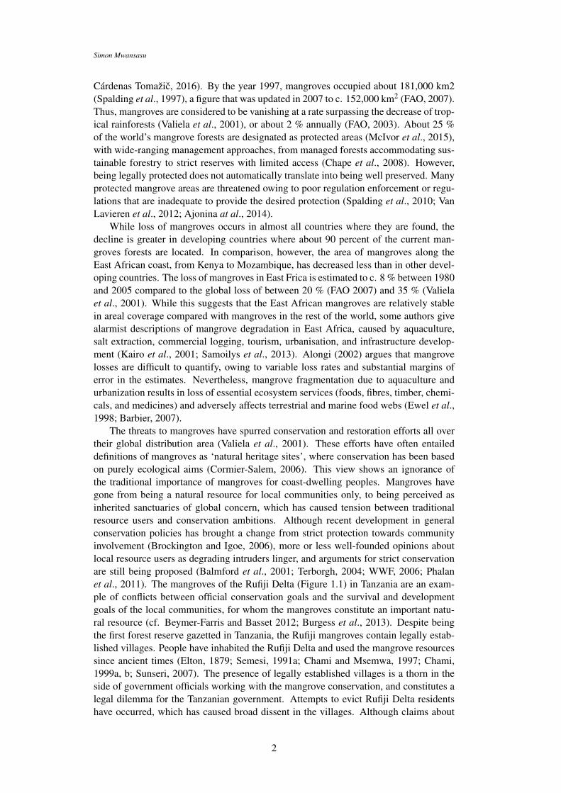
The threats to mangroves have spurred conservation and restoration efforts all overtheir global distribution area (Valiela et al., 2001). These efforts have often entaileddefinitions of mangroves as ‘natural heritage sites’, where conservation has been basedon purely ecological aims (Cormier-Salem, 2006). This view shows an ignorance ofthe traditional importance of mangroves for coast-dwelling peoples. Mangroves havegone from being a natural resource for local communities only, to being perceived asinherited sanctuaries of global concern, which has caused tension between traditionalresource users and conservation ambitions. Although recent development in generalconservation policies has brought a change from strict protection towards communityinvolvement (Brockington and Igoe, 2006), more or less well-founded opinions aboutlocal resource users as degrading intruders linger, and arguments for strict conservationare still being proposed (Balmford et al., 2001; Terborgh, 2004; WWF, 2006; Phalanet al., 2011). The mangroves of the Rufiji Delta (Figure 1.1) in Tanzania are an exam-ple of conflicts between official conservation goals and the survival and developmentgoals of the local communities, for whom the mangroves constitute an important natu-ral resource (cf. Beymer-Farris and Basset 2012; Burgess et al., 2013). Despite beingthe first forest reserve gazetted in Tanzania, the Rufiji mangroves contain legally estab-lished villages. People have inhabited the Rufiji Delta and used the mangrove resourcessince ancient times (Elton, 1879; Semesi, 1991a; Chami and Msemwa, 1997; Chami,1999a, b; Sunseri, 2007). The presence of legally established villages is a thorn in theside of government officials working with the mangrove conservation, and constitutes alegal dilemma for the Tanzanian government. Attempts to evict Rufiji Delta residentshave occurred, which has caused broad dissent in the villages. Although claims about
2
Causes and Perceptions of Environmental Change in the Mangroves of Rufiji Delta
protecting and improving the livelihood of the area’s inhabitants have been included inofficial documents about the protected area (IUCN, 2005; Sandberg, 2010), the issueis still ripe with mutual distrust and misunderstandings, and the combined ambitions ofmangrove conservation and sustainable development for the inhabitants appear to be farfrom being met.
Figure 1.1. Rufiji Delta, Rufiji District, Tanzania. (Source: Paper I)
An example of such conflicts is found in the controversy regarding population growthand agriculture in the Rufiji delta. Neo-Malthusian narratives concerning detrimentaleffects of population increase are common among government officials; these cite theexpansion of rice cultivation as a major threat to the mangroves (Paper I). Meanwhile,local communities claim that the government strives to deprive them of their most impor-
3
Simon Mwansasu
tant livelihood. In this dispute, commercial actors, NGOs, and scientists with interests inthe Delta are involved (Bryceson, 2002; Beymer-Farris and Basset, 2012; Burgess et al.,2013; Daily News, 2014). The debate is highly polarised, such that high conservationaspirations on the one hand clash with provisioning necessities and development am-bitions on the other. Further, communication between stakeholders is encumbered notonly by legal obscurities but also by lack of insights regarding the mangrove environ-ment. While government officials tend to view the Rufiji mangroves as a single, spatiallystatic ecosystem, which at any cost must be protected, it could be argued that the localinhabitants since hundreds of years are part of a mangrove landscape (Paper II). Thesediverging views may serve to illustrate two approaches in ecological conservation; theecosystem approach and the landscape approach (cf. Sayer et al., 2013). The former,in its purest form, tends to emphasise processes within single ecosystems, while thelatter emphasises relations, interactions, and flows between multiple landscape patches(or ecosystems). In highly dynamic environments, such as mangroves, the ecosystemapproach may fail to correctly understand and anticipate processes of environmentalchange.
Conflicts between the Tanzanian government and the local communities in RufijiDelta are not entirely new, and not so simple and clear-cut an issue of either strict pro-tection or socio-economic development. This is shown by the plans in the 1990s toestablish the world’s largest prawn farm in the Rufiji Delta. Conservation of mangrovesis high on the national agenda, as is safeguarding the livelihood of local communities.In spite of this, 19 000 ha of the Delta were granted for prawn farm development bythe Tanzanian government in 1998 (Rönnbäck et al., 2002). The project was eventuallystopped, but it shows that political decisions regarding land availability, conservation,and socio-economic development are issues of contemporary ambitions. A similar situ-ation is starting to develop upstream from the Rufiji Delta (Paper V; see also Havnevik,2009; Neville and Dauvergne, 2012). International biofuel companies have sought togain concession to use available land for large-scale biofuel production. However, theland allegedly available is shown to be yet another case of misreading the landscape andpeople’s use of it (Paper V; cf. Fairhead and Leach, 1996). Large-scale investmentsbased on such erroneous assumptions, may very probably cause sustenance difficultiesfor people, and are likely to, in addition, result in increased population pressure else-where. Should large-scale biofuel investments be granted in the regions upstream of theRufiji Delta, it is likely that the Delta itself would be a target area for people migratingto find livelihood opportunities.
The experiences from the Rufiji Delta indicated above and presented in this thesisshow that current mangrove forest conservation management is defunct. As such, newstrategies are needed, in which conservation is truly coupled to sustainable resource use.Therefore, given the inherent complexities of managing ecosystems exploited by humanactivities, there is clear need for a succinct and objective assessment of the present en-vironmental status of the Rufiji Delta mangroves, which draws support from the currentresearch concerning (1) analysis and measurement techniques and (2) integration andtranslation of local perspectives into relevant policy. Monitoring mangrove distributionis essential for environmental decision-making and good policy. Such monitoring ef-forts must capture and separate between human-induced change and change triggeredby natural ecosystem dynamics, such as fluvial erosion and sedimentation, storm ef-fects, and sea-level variations (cf. Spencer and Möller, 2013). Inherent in mangrovemonitoring, however, is the problem of obtaining data of sufficient quality. In tropicalareas, cloud cover often prevents multi-temporal analysis of sufficient resolution. Newtechniques, including cloud-independent remote sensing capabilities are needed. In this
4

Causes and Perceptions of Environmental Change in the Mangroves of Rufiji Delta
thesis, cloud and illumination independent Synthetic Aperture Radar (SAR) imagery istested for mangrove monitoring.
This thesis sets out to explore and analyse the following assumptions concerning TheRufiji Delta mangroves: (1) Local resource use is destructive (Paper I); (2) populationincrease in the Delta exerts an increasing pressure on the mangroves (Paper I, V); (2)the areal extent of mangroves is decreasing (Paper III, IV); (3) the Rufiji mangroves canonly be conserved by adherence to present conservation legislation, i.e. strict protectionthat necessitates the eviction of existing settlements in the delta (Paper II).
The assumption that local resource use often is destructive is widespread through-out the world among such groups as government officials at different levels and scientistssuch as conservation biologists. This is also the case in Tanzania, and as this thesis showsthis assumption is also held by government officials working with mangrove conserva-tion in the Delta. Here, this perception is reinforced because of an alleged populationincrease in the Delta that in turn is assumed to have led to an encroachment of rice cul-tivation into the Delta mangroves. However, these assumptions have not been verifiedthrough any current empirical research on the development of population and land use inthe Delta, or on mangrove distribution. Although there are studies indicating a decreasein total mangrove area (Wang et al., 2003; Burgess et al., 2013), these studies do notconsider natural mangrove dynamics, fail to relate land use changes with bio-physicaldynamics of the Delta, such as salinity changes caused by delta morphodynamics, andlack the necessary temporal and spatial perspective. The most recent study (Burgess etal., 2013), analyses only the northern part of the Delta (North Delta), thus disregardingchanges in the southern part (South Delta) that potentially may compensate for mangroveloss in the north. Research carried out so far, well described in Burgess et al. (2013),does indicate that mangrove loss in the North Delta is coupled to an increase in land usepressure. However, with regards to the assumptions described above, it is imperative toexamine whether this increase in land pressure is due to an increase in population in theactual Delta, which actors are involved in land use practices affecting mangrove distri-bution, and potential long-term effects of current land use. Establishing answers to thesequestions would undoubtedly be of importance for conservation management, and wouldmost likely be an important factor in reconciling conflicts between government officialsand local Delta communities. Ellison (2015; p. 129) argues that the mangrove protectionlegislation in the Rufiji Delta is ‘good’, while the community management capacity is‘poor’. It is tempting to interpret these attributes as if a strong legislation counteractscommunity involvement. And indeed, Tanzanian legislation concerning forest conserva-tion does not permit community management under the conditions in the Rufiji Delta,i.e. where there exists village land within a state owned forest reserve. Thus, from alegal perspective, there would seem to be but one solution, i.e. massive evictions. How-ever, that would mean a return to what Brockington and Igoe (2006; p. 424) refer to asprotected areas’ murky past. The alternative, which is suggested in the present thesis,and backed up by new empirical evidence which overall refutes several past myths con-cerning the Delta, would mean that the management of the Rufiji mangroves needs tobe adjusted to reflect the specific conditions (historical as well as present) of the area,while adhering to modern thinking on how to manage socio-economic development inconjunction with conservation.
1.1 Study aims and objectives
The overall aim is to contribute to the global debate, both within science and policydecision-making, concerning impacts of human resource use on important biophysical
5

Simon Mwansasu
phenomenon such as biodiversity, and vital ecosystem functions and services. Thus, itis an exploration of environmental change and the causes of this. However, as part ofthis, also this an increasingly important aspect of ongoing debates (within conservationas well as other management practices), it is imperative to conduct such an examinationin a critical manner. Thus, in conjunction with the above, a complementary aim is tocritically examine assumptions of environmental change, which includes taking into ac-count the multiple actors with a stake in present and future environmental resources. Toachieve this an interdisciplinary approach is imperative.
Mangrove areas have for some time now been perceived as threatened ecosystems,resulting in an increased interest within conservation circles, ranging from internationalconservation organisations, through national policies, to grass-root NGOs. The mainobjective of this thesis is to analyse the present debate regarding the Rufiji Delta man-groves by documenting and clarifying different perceptions and standpoints, exploringwith quantitative and qualitative data the value of the arguments put forward, and dis-cussing the possibilities to reconcile the diverging stakeholder interests regarding the Ru-fiji mangroves. To this end, the thesis sets out to investigate the environment of the studyarea and its recent history. The thesis examines the present condition of the mangroves,documents the potential impacts of government conservation policies and managementon the socio-economic situation of local communities in relation to development ambi-tions, and explores causes and perceptions of environmental change and the interactionsbetween people, their livelihood, and the environment. In addition, the thesis examinesmethods of monitoring environmental change.
The specific objectives are to:
• Investigate socio-environmental variables and processes, including drivers of change,that explain the present mangrove landscape through a historical perspective, therebyidentifying examples of change as well as stability. (Papers I, III, IV)
• Critically examine established assumptions and norms concerning the linkagesbetween people, land use practices, livelihood strategies, and natural processes,and how these relate to environmental outcomes in the context of sustainability.(Papers I, II)
• Investigate the actual as well as potential impacts of policies and management sys-tem on the socio-ecological landscape including livelihood opportunities. (PapersII, V)
• Test methods for mangrove monitoring and change detection over time in termsof extent and composition. (Paper III and IV)
1.2 Summary of appended articles
The following table presents a summary of attached articles and manuscripts attached inthe thesis. Two papers have been published (Paper V, 2014 and Paper IV, 2016). Therest (Papers I, II and II) are manuscripts. Paper II is based on qualitative methods, whilepapers III and IV are based on quantitative methods. Papers I and V are based on bothquantitative and qualitative methods.
6

Causes and Perceptions of Environmental Change in the Mangroves of Rufiji Delta
Manuscript I Landscape processes, resource use and conservation ideologies in the RufijiDelta, Tanzania: An examination of population and degradation narratives.
Aims Contribute to the scientific understanding of how the narrative aboutpopulation growth (de facto or assumed) is used in present-day rhetoricand debates, with specific reference to environmental degradation.
Methods Population data analysis; semi-structured group and individual interviews.Results Ujamaa villagization program did not result in population increase in the
Rufiji Delta. Contrary to the perception of authorities, Average AnnualPopulation Growth is in fact decreasing in Rufiji Delta.
Conclusions No impact of population increase on the mangroves. Environmental changesin the Delta are due to natural dynamics.
Manuscript II The Rufiji Delta Mangroves: Conservation with or without people?Aims Analyse the current conservation situation and other uses of the Rufiji
mangroves in a historical perspective; ascertain how collaborativeconservation efforts in the Delta can be implemented.
Methods Environmental historical techniques; semi-structured groupand individual interviews.
Results Contrasting conservation priorities among Rufiji Delta stakeholders(government authorities and the local communities). Current conservationstatus unsustainable.
Conclusions A new model of conservation that accommodates the livelihoodsof local communities needs to be devised.
Manuscript III Multi-decadal L-band SAR observations of the Mangrove forests ofthe Rufiji Delta.
Aims Testing the application of L-band synthetic aperture radar (SAR) toidentify spatio-temporal changes in mangrove forest in the Rufiji Delta.
Methods Ascertain the principle of scattering mechanisms of mangrove standsand neighbouring land cover/land use elements. Analysis of SARSAR images complemented with extensive field verification.
Results No major destruction of the mangrove forest observed; nor was a major(expansion of mangrove area found. Zonation can be crudely identifiedin the image composites.
Conclusions Mangroves of the Rufiji Delta are not a static but dynamic ecosystemecosystem influenced by natural and anthropogenic factors.
Manuscript IV L-band Polarimetric Target Decomposition of Mangroves of the RufijiDelta, Tanzania.
Aims Assessing the potential of L-band PolSAR to investigate the potential ofpolarimetric decomposition to reveal mangrove stand structure.
Methods Processing and analysis of a multi-temporal dataset comprising three ALOSPALSAR polarimetric SAR (PolSAR) scenes.
Results Mangrove polarimetric responses were stable over time, although local(differences occurred, particularly at the seaward edge of the delta.
Conclusions Polarimetric target decompositions can be employed to effectively mapmangrove forest dynamics.
Manuscript V Biofuel potential and land availability: The case of Rufiji District, TanzaniaAims To investigate the hypothesis that there is abundant, idle, or unused land
that can be used for large-scale biofuel production at the local levelin developing countries like Tanzania.
Methods Application of GIS to identify areas of potential biofuel production by aprocess of elimination. Interviews with various stakeholders.
Results The case of Rufiji District demonstrates that the assumption of vastlands being available for biofuel production is incorrect.
Conclusions Large-scale biofuel production can only take place by dispossessingthe local communities of their land.
7

Simon Mwansasu
8
2 The study area
The Rufiji Delta is the oldest forest reserve in Tanzania, and is part of the Rufiji, Mafiaand Kilwa (RMK) Ramsar Site since January 2005 (Sandberg, 2010). The Delta includesthe largest concentration of mangroves on the east coast of Africa, and about 45 % allmangroves in Tanzania (Wang et al., 2003). Geologically, the Delta is underlain byCretaceous and Jurassic limestones and shales. These are overlain by alluvial sand, silt,and clay deposited from the Tertiary period to the present. The deposition of sedimentsby the Rufiji River has produced a deltaic region of dynamically shifting river channels(Mwalyosi, 1990). An example of the latter is the major shift of the Rufiji River inthe 1970s, when the river avulsed from a direction towards the South and Central Deltatowards the North Delta. This shift had major impact on both the mangrove ecosystemand the livelihood of local inhabitants (Paper I).
There are two rainy seasons in the Delta, the Short Rains (vuli) from October toDecember, and the Long Rains (masika) from February to April/May. The average an-nual precipitation is just over 1000 mm, and the temperature ranges from 25◦C to 41◦Cthroughout the year (McSweeney et al., 2010a; McSweeney et al. 2010b).
Six families of mangrove are found in the Delta: Avicenniaceae, Combretaceae,Meliaceae, Rhizophoraceae, Sonneratiaceae and Sterculiaceae (Semesi, 1992). Man-grove species often occur in more or less pure stands, and where stands are mixed, asingle species tends to dominate. Generally, Rhizophora mucronata and Avicennia ma-rina are the most common species. The inner, landward zone is frequently occupiedby Avicennia marina and occasionally by emphCeriops tagal or Lumnitzera racemosa,while the seaward zone is occupied by Sonneratia alba or Avicennia marina (Semesi,1992). The Delta waters support one of the richest wild prawn-fishing grounds in Tan-zania, providing more than 80 % of the country’s prawn exports (Turpie, 2000; Masalu,2003).
Rufiji District has been a part of the western Indian Ocean trade for hundreds ofyears. Mangrove poles from the Delta have been exported to the Gulf States for hun-dreds of years (Sunseri, 2007), and finds of Roman origin indicate that people havelived in the delta for at least 2000 years (Chami, 1999a). Subsistence rice farming, isnot something new in the delta. In the 19th century, early explorers reported that Deltainhabitants practised rice farming (e.g. Elton, 1879; Beardall, 1881). Today the maineconomic activities in the Delta are cultivation, fishing, extraction of forest products,and livestock keeping, in that approximate order of importance (Mbiha and Senkondo,2001). Cultivation occurs at the fringe zones of the mangrove area, and along someof the main rivers, where rain season floods bring fresh water to the fields. With time,the soil in the rice fields becomes too saline. New areas are then cleared for agriculture,while the old fields are abandoned. The location of rice farming demonstrates the naturaldynamics of the Delta (Paper I); contrary to the situation before the major river shift inthe 1970s, rice farming is mostly carried out in the North Delta. After the river avulsion,the South Delta communities have been practising rice cultivation outside the delta.
9

Simon Mwansasu
Figure 2.1. Some of the photos taken in the Rufiji Delta during fieldwork. (A) Housebuilt on poles (dungu) in a rice farm surrounded by mangroves – March 2014. (B)Traditional fish trap in one of the river channels – February 2014. (C) Boat underconstruction using mangrove timber and poles – March 2014. (D) Harvested mangrovepoles awaiting transportation – February 2010. Photos by S. L. A. Mwansasu.
Fishing is an important activity, both as a source of income and as a major sourceof food (proteins). The consumption of mangrove resources related to fishing is theuse of mangrove poles and timber in making canoes and fish traps (Figure 2.1). Unlikerice cultivation, neither the authorities nor the local communities attribute any negativeimpact on the mangroves to fishing.
Trade in mangrove poles still occur. Although carefully regulated through a systemof permits issued by authorities and local communities, poor control and regulation en-forcement have occasionally lead to illegal harvesting (Paper I). In general, trade withagricultural products, fish, and mangrove products is encumbered by poor infrastructure.Many of the roads in the Delta are impassable during rain seasons, and in addition, mar-ket opportunities are erratic, and electricity is in poor supply, which causes problem withstorage facilities (Mbiha and Senkondo, 2001).
Approximately 220 000 people live in Rufiji District, the majority in the RufijiFloodplain and Delta. The level of education is comparatively low; less than 60 % of therespondents of a socio-economic survey carried out by Mbiha and Senkondo (2001) hadattended formal education.
The mangroves of the Rufiji Delta provide many ecosystem services. These includeprovisioning services such as food and fuel, supporting services such as nutrient cycling,and regulation services such as flood regulation (Semesi, 1992; Millennium EcosystemAssessment, 2005). Not all stakeholders in the Rufiji Delta perceive the services accruedfrom the mangrove ecosystem in the same way. In particular, livelihood activities (Fig-ure 2.1) that involve the use of mangrove resources are viewed differently by authorities
10
Causes and Perceptions of Environmental Change in the Mangroves of Rufiji Delta
and by the local communities inhabiting the Delta. Being a traditional use of the man-grove forest to obtain food (carbohydrates), rice farming involves clearing of mangroveareas. This is perceived as mangrove degradation by the authorities (Paper I), and con-sequently, farming constitutes a source of conflict between the authorities and the localcommunities (Paper I and II).
The Rufiji Delta is an area of enormous ecological importance. In 2002, The Inter-national Union for Conservation of Nature (IUCN) identified the Rufiji Delta and thelower Rufiji floodplain as one of the most important wetland areas in East Africa (WWF,2001). Two years later, an area including the Rufiji Delta, was named as a wetland of in-ternational importance under the Ramsar Convention (UNDP, 2012). The qualificationof the Rufiji Delta as a Ramsar site was based on the presence of globally significantpopulations of water bird species, such as the Curlew sandpiper, the Crab plover and theTerek sandpiper. These species surpass in numbers the internationally agreed limit of 1% of the biogeographical population (Nasirwa et al., 2001). The mangroves of the Deltaact as buffers against destructive ocean currents and prevent coastal erosion by boostingsoil deposition (Semesi, 1989). The aquatic system in the Delta is of great importanceto the marine fisheries. Apart from being the breeding ground of several marine species,some of them spend part of their life cycle feeding on the detritus (Mwalyosi, 1993).
Despite its ecological importance and the fact that it supports one third of the pop-ulation of Rufiji District, the Rufiji Delta has received little scientific attention, whichpossibly explains the contrasting ideas and perceptions about environmental change anddegradation in the mangrove ecosystem. The paucity of scientific articles is in contrastwith other areas in Tanzania, e.g. Kondoa District, which has been a focus for a wealth ofscientific research on soil erosion and land reclamation (e.g. Christiansson et al., 1991;Kikula, 1999; Shrestha and Ligonja, 2015). The current thesis attempts to replicate themulti-disciplinary approach taken in Kondoa district (albeit on a much smaller scale).This approach combines earth and environmental science with social science and em-ploys both quantitative and qualitative methods. By this, biophysical conditions, localexperiences, policies, and management perspectives are addressed.
11

Simon Mwansasu
12

3 Material and methods
The research presented in this thesis is based on both quantitative and qualitative meth-ods. Combining quantitative empirical data with traditional ecological knowledge broad-ens the scope of information about environmental change and its effects, and about theprocesses leading to change (Huntington, 2000). Hernández-Cornejo et al. (2005), forinstance, demonstrated how the combination of qualitative methods (interviews) andquantitative methods (remote sensing) rectified an erroneous perception held by respon-dents regarding actual change in mangrove cover. In addition, the interaction betweenthe researcher and the local communities and other relevant stakeholders, such as gov-ernment officials, facilitates both the research process and the dissemination of results(Huntington et al., 2004).
Qualitative methods (interviews) were used to ascertain the impact of local commu-nities’ range of livelihood activities, use of natural resources, recent history and change,and knowledge and perception of environmental change in the Delta. Quantitative meth-ods (remote sensing and GIS) were necessary to analyse the dynamic nature of the Delta(shifting river channels, fluctuating sand deposition and salinity), which influences thedistribution and growth of mangroves in space and time. Neither quantitative nor qual-itative methods could, on their own, have provided adequate answers to the objectivespostulated for this thesis.
Opposing schools of thought about the environmental effects of population increasewere evaluated through quantitative analysis of population trends (Paper I). Degradationnarratives were assessed by analysing stakeholder perceptions (Paper I), and by usingnovel remote sensing methods for mangrove monitoring (Papers III and IV). The currentstatus of mangrove conservation and impacts of conservation policies on local commu-nities were analysed by stakeholder interviews and by comparisons with other modes ofconservation (Paper II). Finally, assumptions by global and national actors about vast ar-eas of land available for biofuel production was challenged using available data on landuse and land cover (Paper V).
3.1 Qualitative methods (Paper I, II and V)
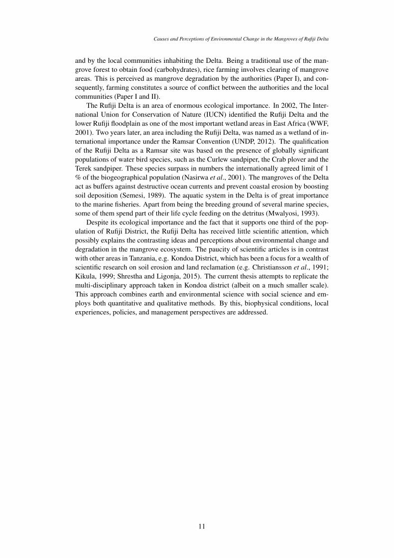
Qualitative data were obtained by interviewing informants and stakeholders with inter-ests in the Rufiji mangroves. Moving from one village to another in the delta environ-ment was only possible by boat through the river channels (Figure 3.1), and the timingof tides was crucial in reaching or leaving the villages, both for interviews and field ver-ification. This has limited the total number of interviews that were possible to carry out.For a detailed description of the interviews, see the respective paper.
Semi-structured group interviews were conducted between 2010 and 2014 in six vil-lages: three in the North Delta and three in the South Delta. Based on a literature reviewand preliminary interviews, a checklist of topics for the semi-structured interviews wasdesigned (Appendix). In addition, preliminary results from the population trend analysis
13
Simon Mwansasu
Figure 3.1. Some of the photos taken in the Rufiji Delta during fieldwork. (A) Navigatinga river channel in the Rufiji Delta – February 2010. (B) Group interview in one of thevillages – June, 2014 (C) and (D) Visiting specific areas in field verification for SARimage analysis – June 2014. Photos by S. L. A. Mwansasu.
were discussed with the group respondents. With the assistance of village leaders, keyinformants, well versed in the history of the Delta, were identified for complementarysemi-structured interviews. In all sample villages, follow-up interviews were conductedto validate emerging issues or to clarify issues earlier discussed in groups or with indi-viduals.
Semi-structured interviews were also conducted with government officials from theforestry, fisheries, agriculture, and livestock departments at district and ward levels, andin addition spontaneous informal interviews were conducted with individual farmersworking in rice fields, both in the North and South Delta. Some problems were encoun-tered during the interviews. In Saninga village, an earlier planned and agreed groupinterview failed as the villagers objected to the presence of the Ward Executive Officer(WEO), whom the villagers accused of siding with the district and forest officials re-garding the issue of rice farming expansion in the Delta. However, the villagers wereprepared to be interviewed at another occasion provided the WEO was not involved.Another challenge, encountered in group interviews, was the tendency of one persondominating the conversation. Typically, this seemed to be a person highly regarded inthe village, and others were reluctant to express their views once he had spoken. Thechallenge was overcome in follow up interviews where the dominant person was notinvolved.
3.2 Quantitative methods (Paper I, III, IV and V)
Previous studies in the study area have tended to rely on either qualitative or quantitativemethods. Beymer-Farris and Basset (2012) exclusively relied on qualitative methods to
14
Causes and Perceptions of Environmental Change in the Mangroves of Rufiji Delta
refute the suggestion that the Ujamaa villagization program had resulted in the degrada-tion of mangroves. Whilst their suggestions concur with the findings in this thesis (PaperI), they did not use quantitative data (census population data) to ascertain their findings.
To complement the results from qualitative methods, population data analysis (PaperI) was necessary. Historical population data and enumeration maps for the censuses of1957, 1967, 1978, and 1988 were used, together with the most recent population data(2002 and 2012) and accompanying maps in digital format. The old paper maps weredigitized and georeferenced in ArcGIS. The Annual Average Population Growth Rate(AAGR) was calculated for the five inter-census periods 1957–1967, 1967–1978, 1978–1988, 1988–2002, and 2002–2012. To examine the population trend in the Rufiji Delta,it was necessary to identify administrative units that could be compared through variouscensuses. Administrative units in Tanzania (village, ward, division, district and region)are occasionally merged or split, or boundaries between units are shifted. Thus, anadministrative unit may not represent the same geographic area through all censuses,with consequential impact on the population data. Analysis of the enumeration mapsrevealed that wards were the administrative units most geographically consistent. In theSouth Delta, the sum of what was Mbwera ward in 1957 has been used for populationtrend analysis. In the North Delta, no single geographically consistent ward could beidentified. However, by comparing two non-delta wards with the delta ward Salale,a rough estimate of population trends for the North Delta was obtained, despite thediscrepancy in ward areas over time. To complement the ward population data presentedin Paper I, population pyramids from selected enumeration centres in the South andNorth Delta were constructed, and are discussed in this thesis summary.
Remote sensing has been employed to explore new methodologies for monitoringand identifying spatio-temporal changes in the mangrove forest (Paper III and IV). Con-trary to optical remote sensors, which have been the most commonly used data sourcefor mapping of mangroves, synthetic aperture radar (SAR) images offer all-weather ca-pabilities and high spatial resolution. Therefore, SAR images from 1994 to 2010 wereused to identify changes in mangrove forest extent and composition in the northern Ru-fiji Delta (Paper III). Similarly, three ALOS PARSAR L-band quad-pol datasets overthe northern and central Delta, acquired on 24th May 2007, 13th April 2009, and 2ndDecember 2010, were used to reveal more information about mangrove stand structure(Paper IV). Although optical satellite imagery has been successfully used to distinguishmangrove species composition (Dahdouh-Guebas et al., 2004), there are no previousinvestigations of the potential of polarimetric decomposition of SAR data (PolSAR) toreveal mangrove stand structure parameters. The analysis of SAR images was com-plemented with field verification of species distribution for areas of interest identifiedduring the image analysis. High-resolution satellite imagery covering the northern Deltawas acquired from Digital Globe to assist in SAR image interpretation. Full exploitationof the PolSAR data was limited by the lack of quantitative data (allometric measures) onthe mangrove forest.
Land use/land cover datasets based on Landsat images taken between 1994 and 1995were used in a geographical information system (ArcGIS) to determine potential areasfor biofuel investment in Rufiji District (Paper V). Potential areas for biofuel investmentswere obtained by a process of elimination. Regardless of the land cover category, all pro-tected areas were first eliminated, as they cannot be considered for biofuel investment.Out of the remaining land, arable land (active or fallowed) as estimated by the districtagriculture officers was deducted. The remaining area was thus deemed as having a po-tential for biofuel investment. The results could have been improved if arable land couldhave been identified in GIS rather than using figures provided by agriculture officers.
15

Simon Mwansasu
16

4 Results and analysis
In this chapter I will first discuss each paper in turn, relating the findings to other stud-ies. Thereafter (main discussion) I will draw on results from several papers to discussfindings and conclusions more directly in relation to the main objectives.
4.1 Population and degradation narratives, landscape processesand resource use in Rufiji District and Rufiji Delta(Paper I)
People living in the Rufiji Delta have been portrayed as recently arrived destroyers of themangroves (Semesi, 1991b; Ngusaru et al., 2001; Wagner, 2008; Wagner and Sallema-Mtui, 2010). Allegedly, the Ujamaa villagization programme in the 1970s, caused amigration to the Delta and a subsequent increase in rice cultivation. This view of peo-ple as recent intruders concurs with the image of mangroves as pristine environments(Cormier-Salem, 2006), untouched by humans and therefore suitable subjects for strictprotection. As this is not supported by empirical research on population trends, a pop-ulation trend analysis is one of the main foci of this thesis, coupled with an analysis ofcurrent land use and landscape dynamics.
A detailed population trend analysis for the North Delta was not possible to carry out,owing to geographical boundaries being inconsistent over time. However, populationtrends of two non-delta wards, during and after the Ujamaa villagization program, werecompared with the population trend of one delta ward (Salale). Although the resultsshall be treated with caution, because of the area discrepancies, the comparison indicatesthat the two non-delta wards had a substantially higher population increase during theUjamaa villagization program (6.1 % and 8.9 %) than the delta ward (2.5 %). After theUjamaa program, however, the population increase of the delta ward rose (4.0 %), whilethe two non-delta wards experienced lower population increase (2.0 % and 3.0 %). Thisis possibly a result of the river avulsion in the 1970s, which has provided the delta wardwith more fresh water then earlier, and made rice cultivation possible to a higher degree.
The situation in the South Delta differs quite markedly from the situation in the NorthDelta. Population statistics indicate an Average Annual Growth Rate approximately onpar with the District, throughout the censuses from 1957 up to 1988. There is thusno indication that the Ujamaa villagization program to any extent led to voluntary orenforced migration to this part of the Delta. Instead, a clear pattern can be ascribed tothe river avulsion. As the dominant fresh-water flow shifted from the south to the north,livelihood opportunities changed in the South Delta, causing a decrease in populationgrowth, and even a population decrease in the latest inter-census period (2002-2012).
Selected enumeration (census) points from both the southern and the northern Deltahave been analysed to broaden the analysis of post-Ujamaa population trends in the en-tire Delta. Four enumeration points were chosen to derive population pyramids, using
17
Simon Mwansasu
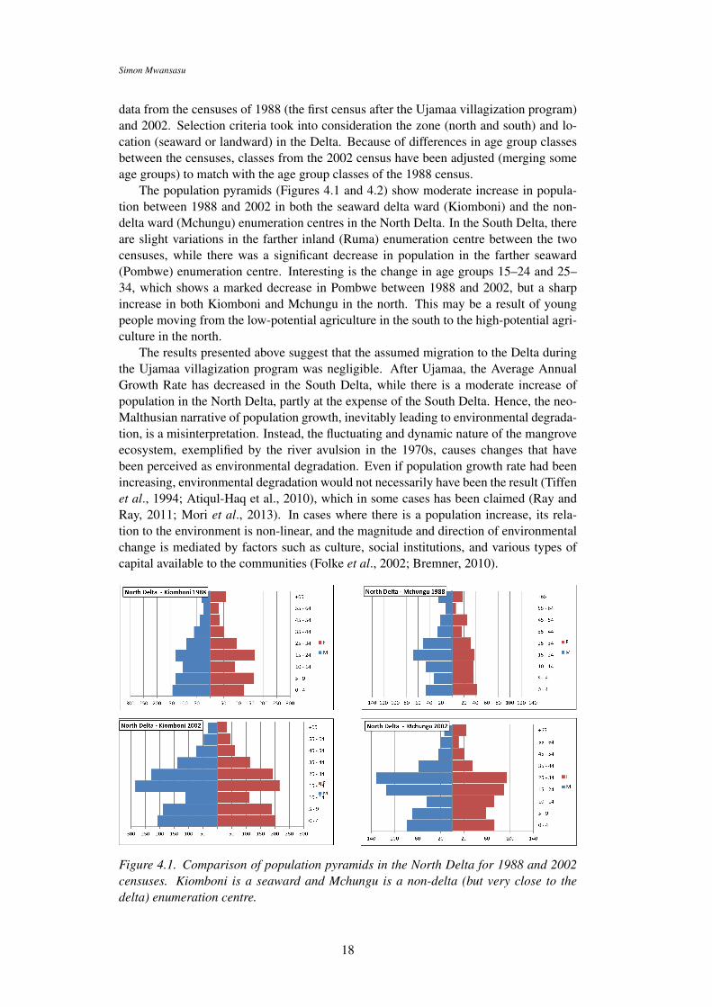
data from the censuses of 1988 (the first census after the Ujamaa villagization program)and 2002. Selection criteria took into consideration the zone (north and south) and lo-cation (seaward or landward) in the Delta. Because of differences in age group classesbetween the censuses, classes from the 2002 census have been adjusted (merging someage groups) to match with the age group classes of the 1988 census.
The population pyramids (Figures 4.1 and 4.2) show moderate increase in popula-tion between 1988 and 2002 in both the seaward delta ward (Kiomboni) and the non-delta ward (Mchungu) enumeration centres in the North Delta. In the South Delta, thereare slight variations in the farther inland (Ruma) enumeration centre between the twocensuses, while there was a significant decrease in population in the farther seaward(Pombwe) enumeration centre. Interesting is the change in age groups 15–24 and 25–34, which shows a marked decrease in Pombwe between 1988 and 2002, but a sharpincrease in both Kiomboni and Mchungu in the north. This may be a result of youngpeople moving from the low-potential agriculture in the south to the high-potential agri-culture in the north.
The results presented above suggest that the assumed migration to the Delta duringthe Ujamaa villagization program was negligible. After Ujamaa, the Average AnnualGrowth Rate has decreased in the South Delta, while there is a moderate increase ofpopulation in the North Delta, partly at the expense of the South Delta. Hence, the neo-Malthusian narrative of population growth, inevitably leading to environmental degrada-tion, is a misinterpretation. Instead, the fluctuating and dynamic nature of the mangroveecosystem, exemplified by the river avulsion in the 1970s, causes changes that havebeen perceived as environmental degradation. Even if population growth rate had beenincreasing, environmental degradation would not necessarily have been the result (Tiffenet al., 1994; Atiqul-Haq et al., 2010), which in some cases has been claimed (Ray andRay, 2011; Mori et al., 2013). In cases where there is a population increase, its rela-tion to the environment is non-linear, and the magnitude and direction of environmentalchange is mediated by factors such as culture, social institutions, and various types ofcapital available to the communities (Folke et al., 2002; Bremner, 2010).
Figure 4.1. Comparison of population pyramids in the North Delta for 1988 and 2002censuses. Kiomboni is a seaward and Mchungu is a non-delta (but very close to thedelta) enumeration centre.
18

Causes and Perceptions of Environmental Change in the Mangroves of Rufiji Delta
Figure 4.2. Comparison of population pyramids in the South Delta for 1988 and 2002censuses. Pombwe is a seaward and Ruma a farther inland enumeration centre com-pared to Pombwe.
The Rufiji river shift in the 1970s brought about changes in land use practices in theDelta. Before the river shift, delta rice cultivation mainly occurred in the South Delta.After the shift, the Northern Delta communities have taken advantage of enhanced freshwater flow to increase rice cultivation, while it has virtually been abandoned in the SouthDelta. Here, local communities have been forced to seek rice fields outside the Delta. In-creased rice cultivation in the north and its abandonment in the south, where mangrovesin different states of vitality now occupy former rice fields, is consistent with Adger’s(2000) argument of a link between social and ecological resilience, when communitiesare dependent on ecological and environmental resources for their livelihoods. That is,environmental change (here, fresh water flows) may lead to social response (here, newlivelihood opportunities). In the Rufiji Delta this has resulted in a shift in resource use,as the northern mangrove area has become more important then the southern mangroves,not only for delta residents, but also for external actors that are involved in rice cultiva-tion and mangrove harvesting. Formerly exploited mangroves in the south are thus in astate of potential regeneration, although the species regenerating so far appear to differfrom the original species composition (cf. Kairo et al., 2001).
4.2 Management of the Rufiji Delta – Conservation with orwithout people? (Paper II)
For centuries, the natural resources of the Rufiji Delta have been a means of survival forthe people living there. They have cultivated rice and harvested coconuts, and they havefished in river channels and the ocean. Apart from using forest products for house andboat construction, people have throughout history also been involved in trading man-grove poles. Rice cultivation occurs both in the Rufiji Floodplain and in the Delta. Con-trary to the situation in the Floodplain, the Delta rice cultivation is largely dependenton an adequate balance between saline and fresh water. This balance shifts in time, andthe Delta cultivation can be described as a shifting cultivation system, in which people
19
Simon Mwansasu
take advantage of enhanced fresh water flows to increase rice cultivation, while aban-doning plots that have become too saline. From the studies described in this thesis, itis evident that the people inhabiting the Delta possess wide knowledge of the behaviourof the complex bio-physical conditions in the Delta, having lived in there for centuries.Gadgil et al. (1993) contends that local communities are capable of accumulating andtransmitting such knowledge from generation to generation. Notwithstanding, rice cul-tivation was and still is perceived by government officials and NGOs with interests inmangrove conservation as recent intrusion causing environmental degradation (Beymer-Farris and Bassett, 2012), without distinction between the activities of local communitiesand outside exploiters (Paper I).
The contradictory perceptions of rice cultivation between local communities andgovernment officials constitute a hindrance to smooth management and conservation ofthe Rufiji Delta. Government officials tend to view the mangroves as a single ecosys-tem, static in time and space, thereby overlooking the processes by which mangrovesdecline in some areas and regrow in other, in response to changing hydrography, fluvialerosion and aggradation. This rather myopic view, epitomizing a purist ecosystem ap-proach, fails to account for the natural dynamics that at some point in time and spacefavour either mangroves or freshwater vegetation (read, rice cultivation). Such divergingways of perceiving and understanding the environment constitute a hindrance to smoothnegotiations and discussions concerning the management and conservation of the RufijiDelta. The government position is that the Delta is a forest reserve that prohibits humanhabitation by law. Consequently, land tenure uncertainty is a major concern to the lo-cal communities, despite having lived in the Delta centuries before it was declared as aforest reserve by the colonial government.
Certain events, some of which occurred and some of which were proposed but didnot materialize, demonstrate the two stakeholders’ commitment, or lack thereof, to theconservation of the Rufiji mangroves. The proposed prawn farming project did not mate-rialize, because of the resistance of the local communities. Arguments forwarded by thelocal communities reflect those of Díaz et al. (2006), i.e. that people who directly dependon natural ecosystems (subsistence farmers, the rural poor and traditional societies), facethe most serious and immediate risks from biodiversity loss and environmental damage.Experiences elsewhere, such as in Fonseca in southern Honduras (Dewalt, 1996), PakPhanang in Thailand (Dierberg and Kiattisimkul, 1996) and India (Hein, 2000), showthat prawn farming projects commonly end up with adverse ecological and economicimpacts. There is no evidence to suggest that the Rufiji Delta would have been an excep-tional success story had the project gone ahead. This suggests that the local communitiesin this instance were more concerned with the conservation of the Delta than the gov-ernment, in spite of the fact that it is the government who tends to accuse the localcommunities of causing environmental degradation. In Gadgil’s et al. (1993) view, localcommunities who for long periods have depended on their local environments for theprovision of various resources, have subsequently developed a stake in conserving, andin some cases enhancing biodiversity.
Conservation with sustainable development of the Rufiji Delta could accommodatethe local communities while meeting conservation goals – provision of ecosystem ser-vices while conserving the ecosystem. For that to happen, the current management ofthe Rufiji Delta as a forest reserve must evolve to legally permit human habitation inthe Delta and thus remove the land tenure uncertainty of local communities. Past andpresent flaws of conservation policies need to be acknowledged, in order to realize pos-itive changes in environmental management (cf. Folke et al., 2002). To achieve sus-tainable conservation, the Rufiji Delta does not necessarily need to be a forest reserve
20

Causes and Perceptions of Environmental Change in the Mangroves of Rufiji Delta
prohibiting the presence of and resource use by local communities. The notion that con-servation implies separation of people from nature ignores the fact that landscapes area product of natural and human processes, engraining cultural as well as environmentalvalues (Neumann, 2003; Dahlberg et al., 2010). According to Spalding et al. (2010),conservation by creating protected areas (separating people from nature) is not alwaysa guarantee for adequate protection and benefits to all stakeholders. Many protectedareas only exist as ‘paper parks’ – legally protected but regulations hardly enforced tocreate any meaningful protection and benefits (Bonham et al., 2008). However, the es-tablishment of Saadani national park in 2005, situated around 200 km north of the RufijiDelta, constitute an example of protection that did not alienate the local communities.Protection has resulted in increased mangrove cover by 10%, thus curbing uncontrolledharvesting, and the resulting conservation has provided gains in income to the local com-munities (McNally et al, 2011).
To sustain the natural environment, institutions and social conditions must be cre-ated to enable the future generations to conceive their own notions of conservation ofsustainable development (Howarth, 2012). Conservation that does not take into accountthe needs of the local communities is bound to fail. Nevertheless, McShane et al. (2011)contends that conservation with sustainable development will vary from place to placeand from time to time even within the same area. Hard choices have to be made andaccepted by all parties involved. It should be a social process that allows compromiseand recognition of risks and costs involved. For conservation and sustainable develop-ment to succeed in the Rufiji Delta, it is imperative to accommodate its unique status –a protected forest reserve with human settlements within its boundaries.
4.3 Spatio-temporal changes in the Rufiji Delta (Paper III)
Policy and decision making in ecosystems management depends on the availability ofspatio-temporal information (Maes, et al., 2012). Remote sensing is capable of provid-ing necessary information on mangrove status and changes in space and time (Dahdouh-Guebas et al., 2004; Kanniah, et al., 2015), and is thus important for monitoring themangrove resources. However, readily available and cheap optical remotely sensed data(e.g. Landsat) can not be used with temporal consistency in the study area because ofpersistent cloud cover. Such problems can be overcome by using spaceborne and air-borne radar-imagery (Kuenzer et al., 2011), which has been applied in various aspectsof mangrove monitoring and mapping (Aschbacher et al., 1995; Kovacs et al. 2006;Lucaset al., 2007; Kovacs et al., 2008; Hong et al., 2015).
This investigation was focused on temporal variation in backscatter across the man-groves of the Rufiji Delta using JERS-1 and ALOS PALSAR images. Both sets ofimages were required to facilitate comparison corrections for differences (Figure 4.3).Analysis of the time series found broad trends that clearly distinguished mangroves,grasslands, bushland and salt pans, cultivated areas, clear cuts and coconut trees, whilethe distribution of individual mangrove species was difficult to characterize. Neverthe-less, field observations, in conjunction with studies of a mangrove species map (Semesi,1989) based on air photo interpretation, suggest that broad spatial distribution patternsstill hold although there are some changes due to natural succession. According toBerger et al. (2006), succession in mangroves is regulated by abiotic factors such asclimate, disturbance (such as cutting), dispersal, and competition. In addition, succes-sion is influenced over space and time by factors regulating survival and growth, such assalinity, inundation and sediment amount and type (Spalding et al., 2010). No major de-struction of mangroves were observed, and there is no evidence that prolonged flooding
21

Simon Mwansasu
due to e.g. the 1997-1998 El Niño has permanently damaged the mangrove forest. Ourresults show that mangroves appear to be more or less in a stable equilibrium althoughthe potential of over-exploitation exists. The 16-year interval SAR data have shown tobe useful for identification of spatio-temporal change in mangrove forests.
Figure 4.3. Images showing radar backscatter differences for the central and northernRufiji delta. The difference is colour-coded thus: blue, backscatter > 5 dB higher in2007 than the comparison year; red, backscatter 0–5 dB higher in 2007; dark green,0–5 dB lower in 2007; light green, > 5 dB lower in 2007. The data were histogrammatched to a PALSAR image from 2010 to normalize backscatter values. The 1994 and1996 data are acquired by JERS-1 SAR and the 2007 data is from ALOS PALSAR.
4.4 The potential of L-band PolSAR data for mangrove forestinvestigations (Paper IV)
Despite the publication of many investigations using remote sensing for mangrove for-est mapping (Kuenzer et al., 2011), none have investigated the effectiveness of polari-metric target decomposition for the analysis of forest composition and structure. Theimportance of species classification when monitoring mangrove ecosystems cannot beoverrated. Unlike in other forests, especially in terrestrial environments, it is very dif-ficult to conduct resource/biomass assessments in mangrove environments, because ofthe heterogeneous character of different species and individuals within species (Rosset al., 2001; Coronado-Molina et al., 2004; Feliciano et al., 2014). This is the firstknown study, which to that purpose investigates the spatio/temporal patterns of backscat-ter mechanism in mangroves using target decompositions.
The aim of the analysis was to determine scattering differences between speciesand over time, testing the potential of L-band PolSAR data. A multi-temporal dataset,comprising three ALOS PALSAR polarimetric SAR (PolSAR) scenes over the northernand central Rufiji delta, was processed and analyzed. Backscatter was decomposed usingeigenvector and backscatter model approaches. The algorithms tested were: (i) entropy-anisotropy-alpha (eigenvector analysis of the coherency matrix), and (ii) Yamaguchi and
22

Causes and Perceptions of Environmental Change in the Mangroves of Rufiji Delta
modified Yamaguchi models (the latter known as the Arii model). The two model-basedtarget decompositions were calculated to describe the scattering contributions (Figure4.4) from the trunk-ground interface (double-bounce), canopy (volume scattering), andground or water surface (surface scattering).
Figure 4.4. Pauli basis representations of the scattering matrices for the three polarimet-ric datasets used in paper IV. The Pauli basis is used to decompose scattering based onthe canonical polarizations. It provides a generalized representation of surface, volumeand double-bounce scattering contributions. In this image surface scattering is encodedin red, volume scattering in blue and double-bounce scattering in green.
The Yamaguchi and Arii model-based target decompositions have shown to differen-tiate between species although mixed-species stands likely preclude automated classifi-cation. Some differences between mangrove species of the Rufiji Delta are also evidentin entropy-anisotropy-alpha. This demonstrates that high resolution L-Band PolSARdata such as from PALSAR-2 could be used to classify species if sufficient validationdata were available.Nevertheless our results show clear temporal differences in the po-larimetric response of grasslands, settlements and agricultural land. In mangrove areas,polarimetric responses were more stable over time except in places where human activi-ties are suspected.
4.5 Biofuel potential and land availability in Rufiji District (Pa-per V)
Mangrove ecosystems, especially those found in river deltas, occupy the interface be-tween land and sea in subtropical and tropical latitudes. Thus, they are influenced byboth inland and offshore processes. This study is an attempt to show the potential im-pact of development activities inland from the delta.
Rufiji District is among the districts that have attracted a considerable number ofpotential biofuel investors (Sulle and Nelson, 2009; Mwakaje, 2012). The attraction isspawned by the narrative that vast tracts of land in Africa are idle and therefore availablefor ‘development’ (Cotula et al., 2009; see also e.g. EcoEnergy, 2014). The assumption
23

Simon Mwansasu
of wide areas of idle land in Rufiji District (Mousseau and Mittal, 2011) may be partlyexplained by its population density. According to the 2012 census, Rufiji District hasthe lowest population density of any district in Tanzania, namely 16 persons per km2,compared to the national average of 50.6 persons per km2.
This study employs a straightforward methodology to quantify land area available forinvestment in biofuels or other commercial produce. The results show that the assumedpresence of land available for large-scale land acquisitions in Rufiji District is incorrect.Protected areas constitute 40 % of the total district area (Table 4.1, Figure 4.5). Thisimplies that the physiological density (total population in relation to arable or farm land)is considerably higher than 16 persons per km2. Arable land (defined as land undercrop production, fallowed land under shifting cultivation and land used for harvestingnatural resources such as fruits, fuelwood, and medicines) constitutes 37% of the total.Accommodating the most conservative request of only one biofuel investor, such as thatof SEKAB/Eco Energy at 250 000 ha or 19 % (Table 1) of the total district area, meansremaining with only 4 % of the total area in the district.
Table 4.1. Rufiji District – land categories, including land targeted for biofuel investmentSource: Paper V.
Item Area × 1000 km2 %
Protected areas 5.2 40Arable land 4.8 37SEKAB/Eco Energy request 2.5 19Balance after SEKAB/Eco Energy request 0.4 4
With 4 % of the area remaining after accommodating the most conservative requestof SEKAB /EcoEnergy, it might seem that their request is feasible. However, there are anumber of issues to take into consideration. Out of 24 central government forest reservesin Rufiji District, only 17 forests possessing reliable forest boundaries were considered.Similarly, district and village council forests were not considered owing to lack of re-liable information on boundaries. A list of forest reserves in Rufiji District (Appendix2, Paper V) provided by the district forest officer does not indicate the size of the then(2011) proposed village forest reserves. Moreover, there are more village forests (not ap-pearing in the list) currently in different stages of being officially gazetted (pers. comm.,Mr. Tarimo, forest officer, Rufiji District, Feb. 2016). The estimated remaining 4 %(40 000 ha) is thus most likely less than the areal sum of not documented central govern-ment, district and village forest reserves. According to the district forest officer, KichiForest alone (one of the not documented District Council forest reserves), exceeds 21 000ha (pers. comm., Mr. Tarimo, forest officer, Rufiji District, Feb. 2016). Granting thewishes of biofuel investors is therefore possible only if land used by the local communi-ties is exploited. Consequently, if biofuel concessions are given to a number of investorsthat have shown interest in Rufiji District, the outcome will be that farmers are forced toseek alternative land for their sustenance (cf. Peters and Thielmann, 2008). Most likely,the Rufiji Delta would be one possible destination (cf. Sunseri, 2009), making the RufijiDistrict an example where biofuel production, indirectly, could interfere not only withfood production, but also with conservation goals (cf. Sulle and Nelson, 2009). Whilethere are global studies that identify potential areas for biofuel investment, such studiesare lacking at the country and local level, especially in developing countries (Fritz et al.,
24

Causes and Perceptions of Environmental Change in the Mangroves of Rufiji Delta
Figure 4.5. Rufiji District – distribution of protected areas and potential for biofuelinvestments. Arable land must be subtracted from area marked ‘Potential for biofuelinvestments’. Source: Paper V.
2013). This study provides a methodology for assessing land availability for large scaleland acquisitions at the local level. It can be applied in any administrative area, as longarea-specific conditions are taken into consideration. However, it is dependent on accessto reliable data on land use and land cover.
25

Simon Mwansasu
26

5 Discussion
Environmental changes may be caused by different factors and may be understood dif-ferently by different people. People may be conscious of existing environmental changesbut unaware of the true causes behind them (Botha and Fouche, 2000), and people mayperceive environmental change in a specific place differently (Barber et al., 2003). Peo-ple may not be in agreement about whether a specific environmental condition representsa change or not, and even in situations where there is agreement, opinions may differconcerning what has caused the change and whether it has had beneficial or harmful ef-fects (Dahlberg, 2000). In Sinaloa, northwestern Mexico, evaluation of spatiotemporalchange in a mangrove area over three decades revealed a discrepancy between the em-pirical assessment of actual change in mangrove cover and what the local communitiesperceived. Remotely sensed data showed increased mangrove vegetation cover, whereasthe local villagers had the opposite perception (Cornejo et al., 2005). The villagers’perception was based on localized intensity of use rather than embracing the entire land-scape vision. This is a case of differing opinions concerning what kind of environmentalchange has taken place. In the Rufiji Delta, the government authorities are of the opinionthat mangroves are being lost due to rice cultivation practised by the local communities,and define this as degradation. As shown in this thesis, the local communities on theother hand, do not perceive rice farming to be a source of environment degradation, butrather a traditional way of using resources in the dynamic mangrove environment. Inaddition, local and national government officials assume that there is a net loss of man-groves in the Rufiji delta, while remote sensing analysis of the area does not show this,but instead shows increase in some areas and a decrease in others.
Environmental change is brought about by natural or human induced factors ordrivers – or a mix of these – that act directly or indirectly on the environment (Nelson,2005; Grant et al., 2008). According to the Millennium Ecosystem Assessment (2005),indirect drivers are demographic, economic, socio-political, scientific/technological, cul-tural, and religious. Direct drivers are, for example, changes in local land use and cover,species introduction or removal, technology adaptation and use, external inputs (e.g. fer-tilizer use, pest control, and irrigation), climate change, and other bio-physical processes(e.g. evolution, volcanoes). In the Rufiji Delta, the two main stakeholders, local commu-nities and the government authorities, agree that one expression of environmental changeoccurring in the area, i.e. mangrove loss and degradation in certain areas, is driven inpart by outsiders that target the Delta for economic reasons. This has become an oppor-tunity partly because conservation policies are not adequately enforced, owing to a lackof human and financial resources. Thus, indirect socio-political and economic drivers ofchange are manifest in the Rufiji mangrove area. Land use and land cover change, in partdriven by opportunistic outside exploitation, involves the clearing of mangroves for ricecultivation, but also the abandonment of old fields in response to changing salinity lev-els. Mangroves in varying degree of robustness regenerate in such abandoned fields. Theresponse of the local communities to environmental change is aimed at sustaining their
27

Simon Mwansasu
livelihoods, such that they take advantage of environmental change that creates opportu-nities (e.g. for rice cultivation), and abandon land where environmental change causesconstraints to a profitable land use. Furthermore, this is not something that happens once,but should be seen as continuous human responses to bio-physical shifts in a dynamiclandscape – where wetlands such as mangroves are more dynamic than most (Mitschand Gosselink, 2000). Such coupling between the social and environmental landscapewill not be apparent without a sufficiently wide spatial and temporal perspective, i.e. alandscape approach.
The impact of different drivers and the responses to them varies, for instance betweendeveloped and developing countries. According to Nelson (2005), socio-political drivershave increased in importance over the past 50 years as a result of increased democracy– such that they today comprise stronger forces than before with an influence on deci-sion making including how the public participates in decision making (see also Berkes,2004). This is claimed to be the result of enhanced educational levels, empowerment oflocal communities and women, and a more democratic involvement of NGOs and grass-root organizations in decision-making processes (Nelson, 2005). However, these are notprocesses that have enfolded at the same pace or magnitude throughout the world, andalso other drivers than these may have an impact. In Rufiji, it is rather the lack of grass-root participation in government decision making and the weak law enforcement – i.e.a lack of democracy – that constitute socio-political drivers of change, as epitomized bythe opportunity seized by outsiders to exploit the mangrove environment.
According to neo-Malthusian narratives, population growth is often blamed for en-vironmental degradation, by exceeding the earth’s carrying capacity and outstripping itsability to provide for its inhabitants (Ehrlich et al., 1993; Scanlan, 2001). Despite beingdiscredited by numerous studies over the years, the neo-Malthusian narrative is surpris-ingly persistent (Adams, 2010). There are many examples where claims of degradationdue to e.g. population growth are not supported by any empirical data or are based onflawed data or inadequate methods (Angelsen and Kaimowitz, 1999). In the Rufiji Deltaand Rufiji District at large, the narrative of population growth is not based on any sci-entific foundation. Instead, it appears to be a case of propagating conventional wisdom(Leach and Mearns, 1996, p. 440). In actual fact, as shown in this thesis, the popu-lation is decreasing in the southern part of the Delta, while the population increase inthe north was very limited during the Ujamaa villagization programme, and thus not themass immigration phase as assumed by some scientists, NGOs and government officials(Semesi, 1991; Ngusaru et al., 2001; Wagner, 2008; Wagner and Sallema-Mtui, 2010).In the post-Ujamaa period the comparatively small influx of people to the northern partof the Delta appears to occur at the expense of population numbers in the southern Delta,as a response to a naturally occurring river avulsion. It is ironic that at the same time asa high population growth is assumed for areas where it is not occurring, in other areasexisting populations are not recognised, as exemplified through the assumed existenceof idle land inland from the Rufiji Delta – i.e. no people there that need or make use ofthe land – which thus can be described as suitable for biofuel investments. That is, twoassumptions are here proven to be incorrect. Thus, in the study area population growthcannot be blamed for environmental degradation, either it is real or simply perceived.This study suggests that the delta mangroves change dynamically in response to bothnatural and anthropogenic factors acting in a wider spatial landscape. While mangrovesdisappear in some areas, they emerge or flourish in other areas, as natural hydrodynamicsaffect the saline/fresh water balance and create conditions in favour of either mangrovesor cultivation. The analysis of Synthetic Aperture Radar images from 1994 to 2010 sug-gest an environment with neither major destruction nor major expansion of mangroves.
28
Causes and Perceptions of Environmental Change in the Mangroves of Rufiji Delta
In conjunction with population growth as a perceived cause of degradation, localcommunities are blamed for environmental degradation through their livelihood activi-ties (Leach and Fairhead 2000). Such perceived degradation, claimed to be caused bylocal communities, was one reason why protected areas were established throughoutmuch of Africa (and elsewhere) in the 19th century (Adams, 2010), and was the reasonalso why the Rufiji Mangroves were gazetted as a forest reserve in the early years ofthe 20th century (Sunseri, 2003). A common and drastic result was the eviction of localcommunities from landscapes they had inhabited for centuries. Also in places wheregovernment interference was not as harsh, outside intervention including restrictions onthe use of land and other resources alienated people from their environment (Neumann,2003; Dahlberg et al., 2010). This did not happen without local resistance, and the estab-lishment of protected areas were generally followed by conflicts between the authoritiesand local communities. Recent attempts to evict the local communities from the RufijiDelta are based on the provisions of the Forest Act of 2002 that prohibits any kind ofhuman habitation in a forest reserve. Such provisions can be seen as relics of the oldcolonial conservation philosophies that have remained in post-independent South Asiaand Sub-Saharan Africa (Adams, 2010), and is an example of a resurgent protectionism(Wilshusen et al., 2002, p. 18; Beymer-Farris and Bassett, 2011) resulting from conser-vationists’ view that participatory approaches to conservation are failing (see e.g. Oates,1999 and Terborgh, 2004). In Rufiji, however, local communities reside legally in theDelta as their villages are registered with land certificates. The government acknowl-edges the legal quagmire and therefore intends to deregister the villages and eventuallyrelocate the local communities to areas outside the Delta. Eviction attempts disregardthe customary rights of the local communities who have lived in the Delta centuriesbefore it was declared a forest reserve, and creates a situation of uncertainty among theDelta residents concerning future land tenure. Despite attempts to evict them, local com-munities have not lost sight of the importance of mangroves to their livelihoods. Thatwas demonstrated by their fierce resistance to a prawn farming project that the govern-ment had intended to implement (Kibugi et al., 2015). Local communities realized theadverse effects of the project to the mangroves and ultimately to their own livelihoodsand put up strong resistance that eventually resulted in the abandonment of the prawnfarming project. This response to outside pressure is a clear example of the role thatlocal communities may play in protecting the environment on which they depend. Arole that would be further enhanced if their participation was accepted, encouraged, andformalised. In fact, local communities may be the best natural allies for conservationists(Berkes, 2004) if conflicts between them can be reconciled. One path to take towardsreconciliation is to acknowledge that land tenure and property rights, including accessto livelihood resources, are critical in the sustainable management of forests (see e.g.Kothari et al., 2012; Bennett and Sierra, 2014 and Fisher et al., 2014).
To overcome conflicts between conservation ambitions and the natural resource useby local communities, efforts to link conservation with local development were initi-ated in Africa and elsewhere the early 1950s (Newmark and Hough, 2000). Similarly,integrated conservation and development projects (ICDP) were initiated in the early1990s, with the aim to initiate new partnership models among stakeholders (Campbelland Vainio-Mattila, 2003; Wells and McShane, 2004). However, in the Rufiji Delta,sustainable conservation that allows for local use of natural resources is hampered bythe current situation – the legal dilemma of a state-owned forest reserve hosting localcommunities with land tenure uncertainty. Current Tanzanian participatory managementapproaches cannot be employed in the area as they are presently formulated and defined.Joint Forest Management (JFM) assumes that local communities reside outside the pro-
29
Simon Mwansasu
tected area (Forest Act of 2002), while Community Based Forest Management (CBFM),on the other hand, cannot be practised in a state forest such as the Rufiji Delta sinceit is aimed for village or private land. A new model must be devised to accommodateboth conservation and sustainable resource use in the Rufiji Delta. Whatever the form ofsuch a model, it has to consider the Rufiji mangroves as a landscape of inter-connectedecosystems in which humans are actors, rather than as a single and static ecosystem.
While rice farming is a traditional resource use of the mangrove environment to thelocal communities, government authorities treat rice farming as an agent of degradation.Thus the official conservation ambition is that rice farming should cease, and fields berestored to their natural state, i.e. the regeneration of mangroves. This perception isexacerbated by the assumption of rapid population growth in the Delta. Thus, in theauthorities’ opinion, sustainable conservation of the mangroves can only be achieved byevicting the local communities from the Delta. These neo-Malthusian narratives, some-times enforced by international NGOs (Daily News, 2014; Naar and Mahenge, 2014),build on the notion that all human interference is negative. Furthermore, as this thesisshows, the view held by government and conservation NGOs, on what constitutes neces-sary actions in order to conserve the mangroves (i.e. the eviction of local communities),neglects the existence of exploitation by outsiders, although this at other times has beenacknowledged by some government officials in agreement with local villagers. Whatalso is neglected, when aims for strict protection including evictions are declared, is thelack of resources needed to enforce conservation regulations – also this acknowledgedby some government officials with direct experience from the Delta. A reconciliationbetween conservation aims and village needs must start with transparent negotiationsbetween government officials working in the Rufiji mangroves and the local commu-nities, where common ground and common goals are acknowledged openly and alsoaccepted by higher authorities. A clear and shared understanding of the dynamics of themangrove landscape, by all stakeholders in the Rufiji Delta, is crucial in defining the roleof each stakeholder in managing the landscape to obtain the desired goal: To preservethe ecosystem services and the biodiversity values of the Rufiji mangroves.
30

6 Concluding remarks
The mangrove forest in the Rufiji Delta is a unique forest reserve in Tanzania. It is theonly state-owned forest containing registered village land within its boundaries. Such asituation constitutes a legal dilemma that has resulted in the condition that local commu-nities are living in constant fear of being evicted. As the management and conservationof the Rufiji Delta depend on the two major stakeholders – the government as ownerof the forest and the local communities inhabiting the Delta – a conservation approachthat addresses the interests of both stakeholders is imperative for the conservation of themangrove forest. This approach must be grounded on updated knowledge on the cur-rent situation concerning mangrove distribution and an understanding of the temporaland spatial dynamics of the mangrove system, including both natural and anthropogenicstressors.
The main conclusions from this thesis are:
• Contrary to the assumptions by government officials and conservation organiza-tions, mangrove change is neither extensive nor occurring as a linear trend overtime. Change in mangrove distribution, both natural and human-induced, shouldnot by default be perceived as degradation, without consideration of wider land-scape dynamics.
• The Rufiji Delta is a dynamic environment, and environmental change is part ofthe Delta’s biogeomorphological evolution. Changes that affect the mangrovesare thus caused both by natural and socio-economic drivers. Direct drivers aree.g. shifts in the salt water–fresh water balance that create varying land use op-portunities and constraints, which in turn either favour rice farming or mangroveregrowth. The management of the mangroves in the Delta must be based on anincreased understanding of these dynamics. Indirect drivers of change that af-fect the Rufiji mangroves are e.g. socio-political processes and conditions that forexample lead to opportunistic exploitation by outside actors cultivating rice andharvesting mangrove poles. Such outside interventions are enabled by managerialshortcomings caused by lack of economic resources.
• Assumptions about the effect of population increase, with an alleged ensuingdegradation, are incorrect. This thesis has shown that changes that have occurredcannot be attributed to the effect of influx of people during the Ujamaa villag-ization program. Neither can changes unequivocally be attributed to populationincrease; there is in fact a population decrease in part of the Delta. However, theimpact of a potential future population growth should not be ignored, especially aslarge inland areas of Rufiji District are targeted for biofuel investments that maycause migration of farmers bereft of land.
• Monitoring change is important for understanding landscape dynamics, includingboth natural biogeomorphological processes and land use/land cover. However, to
31

Simon Mwansasu
enable flexibility in, and planning of, managerial interventions, continuous moni-toring of the condition of the mangrove landscape is an essential part of the man-agement strategy. This thesis has shown that Synthetic Aperture Radar (SAR)imagery is a useful alternative to optical remote sensing sources for monitoring,as it produces cloud- and insolation-independent information on delta and man-grove dynamics.
• None of the forest participatory management approaches established by Tanzanianlaw (Community Based Forest Management and Joint Forest Management) can beimplemented in the Rufiji Delta. A new approach that takes into consideration thepresence of human settlements and the dynamic environment must be devised.
The last point is particularly important, as the two major stakeholders in the Deltamust cooperate to achieve conservation with sustainable development. Land tenure un-certainty must be overcome, for the local communities to participate and benefit fromconservation of the mangrove forest.
32

Acknowledgement
I would like to thank my main advisor Senior Lecturer Dr. Lars-Ove Westerberg and theco-advisers, Associate Professors Annika Dahlberg and Ian Brown for their guidanceduring the entire period of my PhD study. No words can express my gratitude. To Pro-fessor Peter Jansson and Professor Regina Lindborg, my internal reviewers, my thanksgo for their constructive comments. Special thanks to Associate Professor Wilhelm Öst-berg who accompanied me to one of my field visits in the Delta and shared with me hisvast experience in social sciences. To Professor Kjell Havnevik with whom I had a veryfruitful and eye-opening conversation in Uppsala. To the Swedish and Tanzanian coordi-nators of the Natural Resources Management Program – Professor Karin Holmgren andProfessor Pius Yanda respectively.
To my wife Jane Kobole Mwansasu for her patience and understanding all the timesI had to leave her alone while in Sweden. To my lovely daughters Olita and Cristina.
To Senior Lecturers Dr. Helle Skånes for assistance in various aspects at the Depart-ment of Physical Geography and Associate Professor Steve Lyon for valuable commentson the Kappa. To Martin Spångberg, the IT specialist for always being ready with sup-port in IT related issues and to Marcus Andersson for the lessons in the ENVI software.
My colleagues Elikana Kalumanga and Rene Mbanguka – thanks for company andideas. My colleagues Anna Mushi and Tunu Mndeme at the Institute of Resource As-sessment, University of Dar es salaam, for assistance in various aspects of GIS and formoral support.
To the forest officers Frank Sima and Harry Mallya who introduced me to the Delta.And last but not least important, to my sister Professor Agnes Mwakaje for constantencouragement. To all of you and those I could not mention, I say, tack så mycket!
The only regret I have, if there is one, is not having learned the Swedish language,being such a language enthusiast.
Financial support
This PhD project has been supported by the Swedish International Development Agency(SIDA) through the Integrated Natural Resources Management Program executed be-tween the Institute of Resource Assessment (University of Dar es Salaam) and the De-partment of Physical Geography (Stockholm University).
33

Simon Mwansasu
34
References
Adams, W. M. (2010). Green Development – Environment and sustainability in a developingworld. Wiltshire: CPI Antony Rowe.
Adger, W. N. (2000). Social and ecological resilience: are they related? Progress in HumanGeography, 24 (3), 347–364.
Ajonina, G. N., Agardy, T., Lau, W., Agbogah, K., and Gormey, B. (2014). Mangrove condi-tions as indicator for potential payment for ecosystem services in some estuaries of WesternRegion of Ghana, West Africa. In: Diop, S., Barrusseau, J.-P., and Descamps, C. (eds.): TheLand/Ocean interactions in the coastal zone of West and Central Africa, pp. 151–166. Cham:Springer International Publishing.
Alexandris, N., Chatenoux, B., Lopez Torres, L., and Peduzzi, P. (2013). Monitoring mangroverestoration from space. UNEP/GRID-Geneva.
Alongi, D. M. (2002). Present state and future of the world’s mangrove forests. EnvironmentalConservation, 29 (3), 331–349.
Angelsen, A., and Kaimowitz, D. (1999). Rethinking the causes of deforestation: Lessons fromeconomic models. The World Bank Research Observer, 14 (1), 73–98.
Aschbacher, J., Ofren, R., Delsol, J. P., Suselo, T. B., Vibulsresth, S., and Charrupat, T. (1995).An integrated comparative approach to mangrove vegetation mapping using advanced remotesensing and GIS technologies: preliminary results. Hydrobiologia, 295 (1), 285–294.
Atiqul-Haq, S. M., Vanwing, T., and Hens, L. (2010). Perception, environmental degradation andfamily size preference: A context of developing countries. Journal of Sustainable Develop-ment, 3 (4), 102–108.
Balmford, A., Moore, J. L., Brooks, T., Burgess, N., Hansen, L. A., Williams, P., and Rahbek, C.(2001). Conservation conflicts across Africa. Science, 291, 2616–2619.
Barber, J. S., Biddlecom, A. E., and Axinn, W. G. (2003). Neighborhood Social change andperceptions of environmental degradation. Population and Environment, 25 (2), 77–108.
Barbier, E. B. (2006). Natural barriers to natural disasters: replanting mangroves after thetsunami. Frontiers in Ecology and the Environment, 4 (3), 124–131.
Barbier, E. B. (2007). Valuing ecosystem services as productive inputs. Economic Policy, 22(49), 178–229.
Beardall, W. (1881). Exploration of the Rufiji River under the orders of the Sultan of Zanz-ibar. Proceedings of the Royal Geographical Society and Monthly Record of Geography, NewMonthly Series, 3 (11), 641–656.
Bennett, D. E., and Sierra, R. (2014). Multi-scale dimensions of indigenous land tenure in theAmazon. Human Ecology, 42 (4), 551–563.
Berger, U., Adams, M., Grimm, V., and Hildenbrandt, H. (2006). Modelling secondary suc-cession of neotropical mangroves: Causes and consequences of growth reduction in pioneerspecies. Perspectives in Plant Ecology, Evolution and Systematics, 7 (4), 243–252.
Berkes, F. (2004). Rethinking Community-Based Conservation. Conservation Biology, 18 (3),621–630.
Beymer-Farris, B., and Bassett, T. (2012). The REDD menace: Resurgent protectionism in Tan-zania’s mangrove forests. Global Environmental Change, 22 (2), 332–341.
Blomley, T., and Ramadhani, H. (2006). Going to scale with participatory forest management:Early lessons from Tanzania. International Forestry Review, 8 (1), 93–100.
Bonham, C. A., Sacayon, E., and Tzi, E. (2008). Protecting imperilled “paper parks”: Potentiallessons from the Sierra Chinajá, Guatemala. Biodiversity and Conservation, 17 (7), 1581–1593.
35

Simon Mwansasu
Botha, J. H., and Fouche, P. S. (2000). An assessment of land degradation in the northernprovince from satellite remote sensing and community perception. South African Geographi-cal Journal, 82 (2), 70–79.
Bremner, J. (2010). Population, poverty, environment, and climate dynamics in the developingworld. Interdisciplinary Environmental Review, 11 (2/3), 112–126.
Brockington, D., and Igoe, J. (2006). Eviction for conservation: A global overview. Conservation& Society, 4 (3), 424–470.
Bryceson, I. (2002). Coastal aquaculture developments in Tanzania: sustainable and non-sustainable experiences. Western Indian Ocean Journal of Marine Science, 1 (1), 1–10.
Burgess, N. D., Mwakalilia, S., Munishi, P., Pfeifer, M., Willcock, S., Shirima, D., Hamidu,S., Bulenga, G., Rubens, J., and Marchant, R. (2013). REDD herrings or REDD menace:Response to Beymer-Farris and Bassett. Global Environmental Change, 23 (5), 1349–1354.
Callaghan, T. V., Jonasson, S., Nichols, H., Heywood, R. B., and Wookey, P. A. (1995). Arctic ter-restrial ecosystems and environmental change [and Discussion]. Philosophical Transactionsof The Royal Society A, 352 (1699), 259–276.
Campbell, L. M., and Vainio-Mattila, A. (2003). Participatory development and community-based conservation: Opportunities missed for lessons learned? Human Ecology, 31 (3), 417–437.
Cash, D. W., Clark, W. C., Alcock, F., Dickson, N. M., Eckley, N., Guston, D. H., Jäger, J.,Mitchell, R. B. (2003). Knowledge systems for sustainable development. PNAS, 100 (14),8086–8091.
Chami, F. (1999a). Roman beads from the Rufiji Delta, Tanzania: First incontrovertible archae-ological link with the Periplus. Current Anthropology, 40 (2), 237–243.
Chami, F. (1999b). The Early Iron Age on Mafia Island and its relationship with the mainland.Azania: Archaeological Research in Africa, 34 (1), 1–10.
Chami, F., and Msemwa, P. (1997). A new look at culture and trade on the Azania coast. CurrentAnthropology, 38 (4), 673–677.
Chape, S., Spalding, M., and Jenkins, M. (2008). The World’s protected areas. Status, values andprospects in the 21st century. Berkeley, CA.: University of California Press.
Christiansson, C., Kikula, I. S., and Östberg, W. (1991). Man-land interrelations in semiaridTanzania: A multidisciplinary research program. Ambio, 20 (8), 357–361.
Clüsener-Godt, M., and Cárdenas Tomažic, M. R. (2016). The importance of mangrove ecosys-tems for nature protection and food productivity: Actions of UNESCO’s Man and the Bio-sphere Programme. In; Khan, M. A., Ozturk, M. ,Gul, B., and Ahmed, M. Z. (eds): Halophytesfor Food Security in Dry Lands, pp. 125–140. Oxford: Academic Press.
Cormier-Salem, M.-C. (2006). Mangrove: Changes and conflicts in claimed ownership, uses andpurposes. In: Hoanh, C. T., Tuong, T. P., Gowing, J. W., and Hardy, B. (eds): Environmantand livelihoods in Tropical Coastal zones, pp. 163–176. Wallingford, UK, and Cambridge,MA: CAB International.
Coronado-Molina, C., Day, J. W., Reyes, E., and Perez, B.C. (2004). Standing crop and above-ground biomass partitioning of a dwarf mangrove forest in Taylor River Slough, Florida. Wet-lands Ecology and Management, 12 (3), 157–164.
Cotula, L., Vermeulen, S., Leonard, R., and Keeley, J. (2009). Land grab or development op-portunity? Agricultural investment and international land deals in Africa. IIED/FAO/IFAD,London, Rome.
Dahdouh-Guebas, F., Van Hiel, E., Chan, J. C.-W., Jayatissa, L. P. Koedam, N. (2004). Qual-itative distinction of congeneric and introgressive mangrove speices in mixed patchy forestassemblages using high spatial resolution remotely sensed imagery (IKONOS). Systematicsand Biodiversity, 2 (2), 113–119.
Dahlberg, A. C. (2000). Interpretation of environmental change and diversity: A critical ap-proach to indications of degradation – The case of Kalakamate, Northeast Botswana. LandDegradation and Development, 11 (6), 549–562.
Dahlberg, A. C., Rohde, R., and Sandell, K. (2010). National parks and environmental justice:Comparing access rights and ideological legacies in three countries. Conservation and Society,8 (3), 209–224.
36

Causes and Perceptions of Environmental Change in the Mangroves of Rufiji Delta
Daily News (2014). Rufiji paddy farmers live with eviction fear. HTML Document(http://dailynews.co.tz/index.php/features/38682-rufiji-paddy-farmers-live-with-eviction-fear). Accessed on 26th March, 2015.
Dewalt, B. R. (1996). Shrimp aquaculture development and the environment: People, mangrovesand fisheries on the Gulf of Fonseca, Honduras. World Development, 24 (7), 1193–1208.
Díaz, S., Fargione, J., Chapin, F. S., and Tilman, D. (2006). Biodiversity loss threatens humanwell-being. PLoS Biology, 4(8).
Dierberg, F. E., and Kiattisimkul, W. (1996). Issues, impacts, and implications of shrimp aqua-culture in Thailand. Environmental Management, 20 (5), 649–666.
EcoEnergy (2014). Rationale. HTML Document (http://www.ecoenergy.co.tz/get-to-know-us/rationale/). Accessed on 16th February, 2016.
Ehrlich, P. R., Ehrlich, A. H., and Daily, G. C. (1993). Food security, population and environment.Population and Development Review, 19 (1), 1–32.
Ellison, J. C. (2015). Vulnerability assessment of mangroves to climate change and sea-level riseimpacts. Wetlands Ecology and Management, 23 (2), 115–137.
Elton, J.F., 1879. Travels and researches: Among the lakes and mountains of Eastern and CentralAfrica. London: John Murray.
Ewel, K. C., Twilley, R. R., and Ong, J. E. (1998). Different kinds of mangrove forests providedifferent goods and services. Global Ecology and Biogeography Letters, 7 (1), 83–94.
Fairhead, J., and Leach, M. (1996). Misreading the African landscape: Society and ecology in aforest-savanna mosaic. Cambridge: Cambridge University Press.
FAO (2003). Status and trends in mangrove area extent worldwide. Food and Agriculture Organ-isation by the United Nations, Forest Resources Assessment Working Paper 63, Paris.
FAO (2007). The World’s mangroves 1980–2005: A thematic study prepared in the frameworkof the Global Forest Resources Assessment 2005. Food and Agriculture Organisation by theUnited Nations, FAO Forestry Paper 153, Rome.
Feliciano, E. A., Wdowinsky, S., and Potts, M. D. (2014). Assessing mangrove above-groundbiomass and structure using terrestrial laser scanning: A case study in the Everglades NationalPark. Wetlands, 34 (5), 955–968.
Fisher, B., Turner, R. K., and Morling, P. (2009). Defining and classifying ecosystem servicesfor decision making. Ecological Economics, 68 (3), 643–653.
Fisher, J. A., Patenaude, G., Giri, K., Lewis, K., Meir, P., Pinho, P., Rounsevell, M. D. A., andWilliams, M. (2014). Understanding the relationships between ecosystem services and povertyalleviation: A conceptual framework. Ecosystem Services, 7 (3), 34–45.
Folke, C., Carpenter, S., Elmqvist, T., Gunderson, L., Holling, C. S., and Walker, B. (2002).Resilience and sustainable development: Building adaptive capacity in a world of transforma-tions. Ambio, 31 (5), 437–440.
Fritz, S., See, L., van der Velde, M., Nalepa, R.A., Perger, C., Schill, C., McCallum, I., Schep-aschenko, D., Kraxner, F., Cai, X., Zhang, X., Ortner, S., Hazarika, R., Cipriani, A., Bella, D.,Rabia, A. H., Garcia, A., Vakolyuk, M., Singha, K., Beget, M. E., Erasmi, S., Albrecht, F.,Shaw, B. and Obersteiner, M (2013). Downgrading Recent Estimates of Land Available forBiofuel Production. Environmental Science & Technology, 47(3), 1688–1694
Gadgil, M., Berkes, F., and Folke, C. (1993). Indigenous knowledge for biodiversity conserva-tion. Ambio, 22 (2/3), 151–156.
Giddings, B., Hopwood, B., and O’Brien, G. (2002). Environment, economy and society: fittingthem together into sustainable development. Sustainable Development, 10 (4), 187–196.
Giri, C., Pengra, B., Zhu, Z., Singh, A., and Tieszen, L. L. (2007). Monitoring mangrove forestdynamics of the Sundarbans in Bangladesh and India using multi-temporal satellite data from1973 to 2000. Estuarine, Coastal and Shelf Science, 73, 91–100.
Grant, F., Young, J., Harrison, P., Sykes, M., Skourtos, M., Rounsevell, M., Kluvánková-Oravská, T., Settele, J., Musche, M., Anton, C., and Watt, A. (2008). Ecosystem Servicesand Drivers of Biodiversity Change. Report of the RUBICODE e-conference, April 2008.
Havnevik, K. (2009). Outsourcing of African lands for energy and food – challenges for small-holders. Paper (first draft) presented at IPD’s African Task Force, Pretoria, South Africa.
Hein, L. (2000). Impact of shrimp farming on mangroves along India’s East Coast. Unasylva203, 51, 48–55.
37
Simon Mwansasu
Hernández-Cornejo, R. H., Koedam, N., Luna, A. R., Troell, M., and Dahdouh-Guebas, F.(2005). Remote sensing and ethnobotanical assessment of the mangrove forest changes in theNavachiste-San Ignacio-Macapule lagoon complex, Sinaloa, Mexico. Ecology and Society, 10(1), 16.
Hong, S.-H., Kim, H.-O., Wdowinski, S., and Feliciano, E. (2015). Evaluation of polarimetricSAR decomposition for classifying wetland vegetation types. Remote Sensing, 7 (7), 8563–8585.
Howarth, R. (2012). Sustainability, well-being, and economic growth. Minding Nature, 5 (2),32–39.
Huitric, M., Folke, C., and Kautsky, N. (2002). Development and government policies of theshrimp farming industry in Thailand in relation to mangrove ecosystems. Ecological Eco-nomics, 40 (3), 441–455.
Huntington, H. P. (2000). Using traditional ecological knowledge in science: Methods and ap-plications. Ecological Applications, 10 (5), 1270–1274.
Huntington, H., Callaghan, T., Fox, S., and Krupnik, I. (2004). Matching traditional and scientificobservations to detect environmental change: A discussion on Arctic terrestrial ecosystems.Ambio, 13, 18–23.
Hutton, J., Adams, W. M., and Murombedzi, J. C. (2005). Back to the barriers? Changingnarratives in biodiversity conservation. Forum for Development Studies, 32 (2), 341–370.
IUCN (2005). East Africa’s largest mangrove forest wins protection. HTML-document(www.ens-newswire.com/ens/jan2005/2005-01-28-04.html) Accessed 13th Sept., 2015.
Kairo, J. G., Dahdouh-Guebas, F., Gwada, P. O., Ochieng, C., and Koedam, N. (2002 ). Regen-eration status of mangrove forests in Mida Creek, Kenya: A compromised or secured future?Ambio, 31 (7), 562–568.
Kanniah, K. D., Sheikhi, A., Cracknell, A. P., Goh, H. C., Tan, K. P., Ho, C. S., Rasli, F. N.(2015). Satellite images for monitoring mangrove cover changes in a fast growing economicregion in southern Peninsular Malaysia. Remote Sensing, 7 (11), 14360–14385.
Kibugi, R., Wardell, D. A., Cordonier Segger, M. C., Haywood, C., and Gift, R. (2015). Enablinglegal framworks for sustainable land-use investments in Tanzania: Legal assessment report.Working Paper no. 191. Bogor, Indonesia: SIFOR.
Kikula, I. S. (1999). Lessons from twenty-five years of conservation and seven years of researchinitiatives in the Kondoa Highlands of central Tanzania. Ambio, 28(5), 444–449.
Kothari, A., Corrigan, C., Jonas, H., Neumann, A., and Shrumm, H. (Eds.) (2014). Recognizingand supporting territories and areas conserved by indigenous peoples and local communities:Global overview and national case studies. Secretariat of the Convention on Biological Diver-sity, ICCA, Consortium, Kalpavriksh and Natural Justice, Montreal, Canada. Technical Seriesno. 64.
Kovacs, J. M., Vandenberg, C. V., and Flores-Verdugo, F. (2006). Assessing fine beamRADARSAT-1 backscatter from a white mangrove (Laguncularia racemosa (Gaertner))canopy. Wetlands Ecology and Management, 14 (5), 401–408.
Kovacs, J. M., Vandenberg, C. V., Wang, J., and Flores-Verdugod, F. (2008). The use of multipo-larized spaceborne SAR backscatter for monitoring the health of a degraded mangrove forest.Journal of Coastal Research, 24 (1), 248–254.
Kuenzer, C., Bluemel, A., Gebhardt, S., Quoc, T. V., and Dech, S. (2011). Remote sensing ofmangrove ecosystems: A review. Remote Sensing, 3 (5), 878–928.
Leach, M., and Fairhead, J. (2000). Challenging neo-Malthusian deforestation analyses in WestAfrica’s dynamic forest landscapes. Population and Development Review, 26 (1), 17–43.
Leach, M., and Mearns, R. (1996). Environmental Change and Policy. In: Leach, M., andMearns, R. (eds): The lie of the land: Challenging received wisdom of the African continent,pp. 1–33. Oxford: James Currey.
Lucas, R. M., Mitchell, A. L., Rosenqvist, A., Proisy, C., Melius, A., and Ticehurst, C. (2007).The potential of L-band SAR for quantifying mangrove characteristics and change: case stud-ies from the tropics. Aquatic Conservation: Marine and Freshwater Ecosystems, 17 (3), 245–264.
38
Causes and Perceptions of Environmental Change in the Mangroves of Rufiji Delta
Maes, J., Egoh, B., Willemen, L., Liquete, C., Vihervaara, P., Schägner, J. P., Grizzetti, B.,Drakou, E. G., La Notte, A., Zulian, G., Bouraoui, F., Paracchini, M. L., Braat, L., Bidoglio, G.(2012). Mapping ecosystem services for policy support and decision making in the EuropeanUnion. Ecosystem Services, 1 (1), 31–39.
Masalu, D. C. (2003). Challenges of coastal area management in coastal developing coun-tries—lessons from the proposed Rufiji delta prawn farming project, Tanzania. Ocean andCoastal Management, 46 (1–2), 175–188.
Mbiha, E. R., and Senkondo, E. M. M. (2001). A socio-economic profile or the Rufiji floodplainand delta. Environmental management and biodiversity conservation of forests, woodlands,and wetlands of the Rufiji Delta and Floodplain. Technical report No. 6, Rufiji EnvironmentManagement Project, Dar es Salaam, Tanzania.
McIvor, A., Spencer, T., Spalding, M., Lacambra, C., and Möller, I. (2015). Mangroves, tropicalcyclones, and coastal hazard risk reduction. In: Ellis, J. T., Sherman, D. J., and Shroder Jr, J. F.(eds): Coastal and marine hazards, risks, and disasters (pp. 403–429). Amsterdam: Elsevier.
McNally, C. G., Uchida, E., and Gold, A. J. (2011). The effect of a protected area on the tradeoffsbetween short-run and long-run benefits from mangrove ecosystems. PNAS, 108 (34), 13945–13950.
McShane, T. O., Hirsch, P. D., Trung, T. C., Songorwa, A. N., Kinzig, A., Monteferri, B.,Mutekanga, D., Van Thang, H., Dammert, J. L., Pulgar-Vidal, M., Welch-Devine, M., Bro-sius, J. P., Coppolillo, P., O’Connor, S. (2011). Hard choices: Making trade-offs betweenbiodiversity conservation and human well-being. Biological Conservation, 144(3), 966–972.
McSweeney, C., New, M., and Lizcano, G. (2010a). UNDP climate change country profiles:Tanzania. Pdf.file (http://country-profiles.geog.ox.ac.uk/). Accessed 13th Sept., 2015.
McSweeney, C., New, M., Lizcano, G., and Lu, X. (2010b). The UNDP climate change countryprofiles improving the accessibility of observed and projected climate information for studiesof climate change in developing countries. Bulletin of the American Meteorological Society,91 (2), 157–166.
Millennium Ecosystem Assessment (2005). Ecosystems and human well-being: Synthesis. Wash-ington DC.: Island Press.
Mitsch, W. J., and Gosselink, J. G. (2000). Wetlands. New York: Wiley.Mori, A. S., Furukawa, T., and Sasaki, T. (2013). Response diversity determines the resilience of
ecosystems to environmental change. Biological Reviews, 88 (2), 349–364.Mousseau, F., and Mittal, A. (2011). Understanding land investment deals in Africa. Country
Report: Tanzania. Oakland, CA: The Oakland Institute.Mwakaje, A. G. (2012). Can Tanzania realise rural development through biofuel plantations?
Insights from the study in Rufiji District. Energy for Sustainable Development, 16 (3), 320–327.
Mwalyosi, R. (1990). Resource potentials of the Rufiji River Basin, Tanzania. Ambio, 19 (1),16–20.
Mwalyosi, R. (1993). Management of the Rufiji Delta as a Wetland. In: Kamukala, G. L., &Crafter, S. A. (eds): Wetlands of Tanzania – Proceedings of a seminar on Wetlands of Tan-zania, Morogoro, 27–29 Nov. 1991 (pp. 115–124). International Union for Conservation ofNature and Natural Resources. Gland: IUCN Communications Division.
Naar, N. ,and Mahenge, J. (2014). Finding a middle ground: Conservation challenges amongstakeholders in coastal Tanzania. Anthropology Today, 30 (1), 9–14.
Nasirwa, O., Owino, A., Munguya, E., and Washira, J. (2001). Waterbird counts in the RufijiDelta, Tanzania. Dar es Salaam: Rufiji Environment Management Project.
Nelson, G. C. (2005). Drivers of ecosystem change (summary chapter). In: Hassan, R., Scholes,R., and Ash, N. (eds): Millennium Ecosystem Assessment Series: Ecosystems and HumanWell-being: Current State and Trends (Vol. 1), pp. 73–76. Washington, DC: Island Press.
Neumann, R. P. (2003). The production of Nature – Colonial recasting of the African landscapein Serengeti National Park. In: Zimmerer, K. S., and Bassett, T. J. (eds): Political ecology: Anintegrative approach to geography and environment-development studies, pp. 240–255. NewYork: The Guilford Press.
Neville, K., and Dauvergne, P. (2012). Biofuels and the politics of map making. Political Geog-raphy, 31 (5), 279–289.
39

Simon Mwansasu
Newmark, W. D., and Hough, J. L. (2000). Conserving wildlife in Africa: Integrated conservationand development projects and beyond. BioScience, 50 (7), 585–592.
Ngusaru, A.S., Mgaya, Y.D., Francis, J., and Sosovele, H. (2001). Root causes of biodiversityloss in Rufiji-Kilwa-Mafia and Mnazi Bay-Ruvuma estuary in Tanzania. WWF African MarineEcoregion (EAME) Programme, Tanzania.
Oates, J. F. (1999). Myth and reality in the rain forest: How conservation stategies are failing inWest Africa. Berkeley: University of California Press.
Peters, J., and Thielmann, S. (2008). Promoting biofuels: Implications for developing countries.Energy Policy, 36 (4), 1538–1544.
Phalan, B., Onial, M., Balmford, A., and Green, R. E. (2011). Reconciling food production andbiodiversity conservation: land sharing and land sparing compared. Science, 333, 1289–1291.
Ray, S., and Ray, I. A. (2011). Impact of population growth on environmental degradation: Caseof India. Journal of Economics and Sustainable Development, 2 (8), 72–77.
Rönnbäck, P., Bryceson, I., and Kautsky, N. (2002). Coastal aquaculture development in EasternAfrica and the Western Indian Ocean: Prospects and problems for food security and localeconomies. Ambio, 31 (7), 537–542.
Ross, M. S., Ruiz, P. L., Telesnicki, G. J., and Meeder, J. F. (2001). Estimating above-ground biomass and production in mangrove communities of Biscayne National Park, Florida(U.S.A.). Wetlands Ecology and Management, 9 (1): 27–37.
Roth, L. C. (1992). Hurricanes and mangrove regeneration: Effects of hurricane Joan, October1988, on the vegetation of Isla del Venado, Bluefields, Nicaragua. Biotropica, 24 (3): 375–384.
Rounsevell, M. D., Dawson, T. P., and Harrison, P. A. (2010). A conceptual framework to assessthe effects of environmental change on ecosystem services. Biodiversity and Conservation, 19(10), 2823–2842.
Rubin, J. A., Gordon, C., and Amatekpor, J. K. (1999). Causes and consequences of mangrovedeforestation in the Volta Estuary, Ghana: Some recommendations for ecosystem rehabilita-tion. Marine Pollution Bulletin, 37 (8–12), 441–449.
Samoilys, M., Maina, G. W., Church, J., Mibei, B., Monjane, M., Shah, A., Mutta, D., and Pabari,M. (2013). Situation analysis for Mangroves for the Future: Understanding the resilienceof coastal systems. Nairobi: CORDIO East Africa, IUCN, Nairobi Convention Secretariat(UNEP).
Sandberg, A. (2010). Institutional challenges to robustness of flood plain agricultural systems.Environmental Hazards, 9 (3), 284–300.
Sayer, J., Sunderland, T., Ghazoul, J., Pfund, J.-L., Sheil, D., Meijaard, E., Venter, M., Boedhi-hartono, A. K., Day, M., Garcia, C., van Oosten, C., and Buch, L. E. (2013). Ten principlesfor a landscape approach to reconciling agriculture, conservation, and other competing landuses. PNAS, 110 (21), 8349–8356.
Semesi, A. (1989). Conserving the mangrove forests of East Africa: The case of Rufiji DeltaMangrove, Tanzania. Paper presented to a workshop on Marine Sciences in East Africa. 14–16 November, Dar es Salaam.
Semesi, A. (1991a). Mangrove resource of the Rufiji Delta, Tanzania. Wetlands ConservationConference for Southern Africa – Proceedings of the SADCC wetlands conference. The IUCNwetlands Programme. 1992.
Semesi, A. (1991b). Management plan for the mangrove ecosystem of mainland Tanzania, Vol.11: Mangrove management plan for all coastal districts. Ministry of Tourism, Natural Re-sources and Environment, Forest and Beekeeping Division, Catchment Forest Project, Dar esSalaam.
Semesi, A. (1992). Developing management plans for the mangrove forest reserves of mainlandTanzania. Hydrobiologia, 247(1), 1–10.
Shrestha, R. P., and Ligonja, P. J. (2015). Social perception of soil conservation benefits in Kon-doa eroded area of Tanzania. International Soil and Water Conservation Research, 3 (3), 183–195.
Spalding, M., Blasco, F., and Field, C. D. (1997). World mangrove atlas. The International Soci-ety for Mangrove Ecosystems, Okinawa, Japan.
Spalding, M., Kainuma, M., and Collins, L. (2010). World atlas of mangroves. London andWashington: Earthscan.
40

Causes and Perceptions of Environmental Change in the Mangroves of Rufiji Delta
Spencer, T., and Möller, I. (2013). 10.14 Mangrove systems. In: Shroder, J. F. (ed.): Treatise ongeomorphology (Vol. 10), pp. 360–391. San Diego: Academic Press.
Sulle, E., and Nelson, F. (2009). Biofuels, land access and rural livelihoods in Tanzania. London:IIED.
Sunseri, T. (2003). Reinterpreting a colonial rebellion: Forestry and social control in GermanEast Africa, 1874–1915. Environmental History, 8 (3), 430–451.
Sunseri, T. (2007). Fueling the city: Dar es Salaam and the evolution of colonial forestry, 1892–196. In: Brennan, J. R., Burton, A., and Lawi, Y. (eds): Dar es Salaam – History from anemerging African Metropolis (pp. 13–75). Dar es Salaam: Mkuki na Nyota.
Sunseri, T. (2009). Wielding the axe: State forestry and social conflicts in Tanzania, 1820–2000.African Studies Review, 53 (3), 165–167.
Terborgh. J. (2004). Requiem for nature. Washington DC: Island Press.Tiffen, M., Mortimore, M., and Gichuki, F. (1994). More people, less erosion: Environmental
recovery in Kenya. Chichester: John Wiley.Turpie, J. (2000). The use and value of natural resources of the Rufiji Floodplain and Delta,
Tanzania. Environmental management and biodiversity conservation of forests, woodlands,and wetlands of the Rufiji Delta and Floodplain. Technical report No. 17, Rufiji EnvironmentManagement Project, Dar es Salaam, Tanzania.
Valiela, I., Bowen, J. L., and York, J. K. (2001). Mangrove forests: One of the World’s threatenedmajor tropical environments. BioScience, 51 (10), 807–15.
Van Hue, L. T., and Scott, S. (2008). Coastal livelihood transitions: Socio-economic conse-quences of changing mangrove forest management and land allocation in a commune of cen-tral Vietnam. Geographical Research, 46 (1), 62–73.
Van Lavieren, H., Spalding, M., Alongi, D. M., Kainuma, M., Clüsener-Godt, M., and Adeel, Z.,(2012). Securing the future of mangroves. Policy brief, UN University, Institute of Water andEnvironmental Health, Hamilton, Canada.
Wagner, G. (2008). Baseline assessment of the mangroves ecosystems of Rufiji, Mafia and Kilwa,Tanzania for vulnerability to climate change. GEF/ WWF US Coastal Resilience to ClimateChange Project in Tanzania, Fiji and Cameroon.
Wagner, G., and Sallema-Mtui, R. (2010). Change analysis of Rufiji-Mafia-Kilwa mangroves,Tanzania in relation to climate change factors and anthropogenic pressures. WWF TanzaniaCountry Office, Dar es Salaam, Tanzania.
Walters, B. B., Rönnbäck, P., Kovacs, J. M., Crona, B., Hussain, S. A., Badola, R., Primav-era, J. H., Barbier, E. and Dahdouh-Guebas, F. (2008). Ethnobiology, socio-economics andmanagement of mangrove forests: A review. Aquatic Botany, 89 (2), 220–236.
Wang, Y., Bonynge, G., Nugrand, J., Traber, M., Ngusaru, A., Tobey, J., Hale, L., and Makota,V. (2003). Remote sensing of mangrove change along the Tanzania coast. Marine Geodesy,26 (1–2), 35–48.
Wilshusen, P. R., Brechin, S. R., Fortwangler, C. L., and West, P. C. (2002). Reinventing a squarewheel: Critique of a resurgent "Protection Paradigm" in international biodiversity conserva-tion. Society and Natural Resources, 15, 17–40.
WWF (2006). East African Mangroves – Ecoregion – WWF. HTML Document(http://www.worldwildlife.org/ecoregions/at1402) Accessed 18th Feb. 2016.
WWF (2001). Proceedings of the East African Marine Ecoregion. Ecoregion Visioning work-shop. (p. 36). Mombasa: WWF.
41

Simon Mwansasu
42
Appendix: Checklist for group andindividual interviews.
Government officials interviewed were stationed at the main office in Kibiti and substa-tions in Nyamisati and Mohoro.
For all respondents in group interviews and individual interviews, the following in-formation was recorded: name, age, gender, marital status, occupation and personalhistory. For government officials, also title, duties, and length of service at the presentwork place were noted.
1. What is the mangrove ecosystem to you?2. Factors affecting the well-being of the mangroves?3. What is link between the well-being of the mangroves and your own well-being in theDelta?4. What natural resources do you use in the Delta (in mind – salt production, grass/sedges/reeds,fuel wood, mangrove poles/timber, fishing, honey harvesting, etc.)? Who uses what?5. How is land used in the Delta? What are the different uses? Who uses what and when(seasons, years)?6. How has the Delta changed in your lifetime? Why and when?7. What do you think about the future of the Delta and the mangroves?8. What are your main economic activities (in order of importance)? Who are involvedin each activity at family level (men, women, both, children)?9. Do you know of any areas that have been cleared years back and where there are nowmangroves?
If yes, why cleared?Do those areas regenerate?Which species emerge (same or different)?If cultivated, which crop(s)?Why choose a particular area for cultivation?How many years of cultivation before abandoning to clear new areas?Why abandon to start new areas?
Who owns the farm?Since when?How did ownership start (clearing, inheritance, etc.)?
10. Ujamaa villagization program. Did people migrate to or out of your village?11. Management of the mangrove resources (Forest regulations, settlements in theDelta).
43