Embed Size (px)
Citation preview
CATZ-I SummaryDelMarVa • August 29th, 2007
A very successful medium-size campaign was conducted on Aug 29th comprised of 4
on-track (day overpass in yellow) Cimel sites primarily located in Eastern MD, plus
an additional Cimel collocated with the MPL (SMART) in Pennsylvania about 4 km off
track (see image map). The Cimel locations were distributed about 12km apart.
AOD500nm was moderate (ranging from 0.4 - 0.5) for the day across the region.
The sites were within 50-150m of the projected overpass track. All sites acquired
cloud-free or nearly cloud-free principal plane measurements about 5-10 minutes
before the satellite overpass as well as numerous cloud-free AOD measurements over
the course of the day including near overpass. Successfully retrieved almucantars
were also acquired at the start of the day.
The conditions were frequently favorable for joint inversion purposes (minimal cloud
contamination of principal plane measurements).
Day overpass sites
Morgnec Road (Joel) 39°13'57.20"N 76° 1'42.09"W
Church Hill Road (Mikhail) 39° 8'4.72"N 75°59'47.73"W
Dean Road (Dave) 39° 1'36.36"N 75°57'55.71"W
1
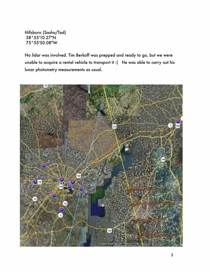
Hillsboro (Sasha/Tad) 38°55'10.27"N 75°55'50.08"W
No lidar was involved. Tim Berkoff was prepped and ready to go, but we were
unable to acquire a rental vehicle to transport it :( He was able to carry out his
lunar photometry measurements as usual.
2
Site Reports
Morgnec:
Set-up @ 9:45First manual almucantar- 9:55 Fully cloud-free conditions.
Cloud cover was quite variable all day. Mostly limited to a deck of thin cirrus haze, or small cumulus around the periphery.
10:00Completely cloudless11:00 Some scattered cumulus with hazy cirrus covering the solar disk and vicinity. All AOD measurements have some cirrus contaminationFrom 11 to 12: A complete transition from nearly cloudless to 90% overcast back to cloudless in less than an hour.11:50 Several very good --cloud-free-- principal plane (PP) measurements followed bya very good almucantar12:00 Clear, but with the faintest layer of uniform cirrus including the area of thesolar disk13:00Clear, but with continued cirrus deck14:00Clear, cirrus dissipating14:05 to 14:15- Most PP were perfect during this period with only a solitary small cumulus in the middle of the scan path14:20 (Overpass) Cirrus fully gone. AOD measurements are all good through at least 15:0015:00Partly sunny, some shallow cumulus increasing, still no cirrus influencing AOD16:15Final almucantar (good quality), followed by PP (perfect)
Hillsboro:
(notes Tad Anderson took during our joint endeavor)
Instrument #409 Hillsboro, near Butler Rd
Aug 29, 2007, CALIPSO overpass near Hilltop MD set up at corner of of Hillsboro Rd and Butler Rd10:30 EDT turn on Cimel, do almucanter, very clear11:30 Ci approaching from west11:45 thin Ci in front of sun12:35 sun clear but still scat Ci all around
3

13:05 Ci in front of sun13:15 sun clear13:30 Ci in front of sun13:40 sun clear, scat Ci nearby14:00 sky mostly clear14:05 Prin. Plane scan (should be all clear)14:15 PP scan14:20 overpass (18:20 UTC), isolated Cirrocumulus near sun but not in front of sun14:25 PP scan; lots of scattered Ci (or maybe Altocumulus) toward back horizon14:28 sun blocked briefly by edge of Ci14:30 sun in clear again14:35 PP scan but Cirrocum on both sides of sun plus more on back horizon14:38 sun blocked briefly14:40 sun blocked by fairly thick Ci14:58 sun in clear (barely)15:00 back to auto mode operation of Cimel~15:20 shut down due to extensive, cumuliform clouds in all parts of sky- no chance for 4pm almucantar
Dean Road
I setup at the Ruthsburg community center near Dean Road (~130 meters from the predicted track). The day was characterized by light morning haze with cirrus and mid-level clouds developing and diminishing periodically throughout the day with cu-mulus forming later in the afternoon. The initial almucantar and principal planes should be good, while later principal planes were usually cloud contaminated at large scattering angles. A good principal plane may have been taken just before the overpass. The AOD measurements should be good at overpass time. The late princi-pal plane and almucantars were not possible due to cumulus clouds blocking the sun.
Dave
Calipso_Dean_Rd:EDT9:30 - setup; taking AOD measurements9:37 - ALM; clear skies with light haze10:07 - ALM, clear skies with light haze10:15 - PP, clear for PP; cirrus clouds developing10:30 - PP, potential cirrus contamination near sun10:58 - PP, some cirrus contamination at large scattering angles11:04 - increasing cirrus coverage near sun11:10 - PP; no cirrus near sun but cirrus contamination at large scattering angles
4

11:30 - cirrus overhead11:40 - cirrus and alto cumulus forming overhead12:05 - clouds diminishing near sun12:10 - remnant hydrated aerosols (twilight zone?) in wake of dissipating clouds; PP, no apparent cloud contamination12:17 - BCL_SUN affected by cloud12:21 - PP; early scan OK but clouds formed near sun for later wavelengths12:23 - mid-level cumulus now redeveloping near sun12:26 - clouds near sun12:29 - altocumulus dissipating near sun12:36 - PP; some possible cloud contamination at large scattering angles12:39 - BCL_SUN12:43 - PP; some possible cloud contamination at large scattering angles12:47 - BCL_SUN resumed; cirrus and alto cumulus clouds developing overhead and near sun12:52 - started BCL_SKY12:57 - resumed BCL_SUN13:01 - clouds dissipating near sun13:13 - BCL_SKY; significant altocumulus overhead and blocking sun13:27 - Resume BCL_SUN13:30 - PP; light haze and clouds dissipating in most of principal plane; some cloud contamination at large scattering angles13:34 - resume BCL_SUN13:41 - PP; cloud contamination at large scattering angles13:46 - BCL_SUN - no clouds blocking sun13:50 - PP; some cloud contamination at large scattering angles13:55 - BCL_SUN; no clouds blocking sun14:05 - PP; some clouds at large scattering angles14:10 - cirrus clouds developing near sun14:14 - PP; apparently no cloud contamination14:18 - BCL_SUN; no clouds blocking sun but nearby14:20 - Overpass; clouds near but no blocking sun14:25 - PP; some cloud contamination at large scattering angles14:29 - BCL_SUN; no clouds obscuring sun; light haze14:33 - clouds blocking sun14:40 - clouds dissipating near sun14:44 - PP; cloud contamination at large scattering angles14:48 - BCL_SUN; clouds not obscuring sun 15:00 - Automatic mode - clouds near sun and increasing in coverage15:07 - ALM - clouds in the east15:15 - PP - clouds in the east15:41 - Cumulus clouds blocking sun15:43 - Cumulus clouds developing overhead; start BCL_SKY
5

15:45 - Almucantar not possible16:00 - Significant cumulus and cirrus clouds blocking sun; PP and ALM not possible
Church Hill Road:
Site location: 39.1326N 75.9991W
On east shoulder of Church Hill road, mowed off strip of field, no trees butone pole. Start measurements around 14:20GMT, clear sky, haze,cirrus-stratus and alto-cumulus on horizon around.
15:10GMT Low dencity, thin clouds move in against the sun.15:20 Clear sky, haze.16:40 Scattered developing cumulus.17:10 Clear again.18:10 Single thin cloud in SUN view.19:00 clear in sun direction, scattered clouds around.20:10 Finished the measurements after ALM and PP.
SERC-- night measurements:
Due to equipment issues a lidar was not available for measurements (day or night). I did however, go to the top of the SERC tower for Cimel lunar measurements, ap-proximately 1 km east of the nighttime track, and recorded several measurements. The conditions were partly cloudy at the time of overpass (07:16:32 UTC), but there was a clear opening a couple of minutes before and after when transmission meas-urements were possible. The Cimel will remain at SERC for routine day observa-tions, and could be used again for future nighttime CALIPSO overpasses. The CA-LIPSO nighttime track is expected to pass very close to SERC every 16 days.
Tim
6