Embed Size (px)
Citation preview

a walk in the footsteps of Romans and a 19th century industrialist, through a woodland nature reserve and on to a fascinating village with an unusual church
Carlisle and Wreay following the River Petteril
Lake Distict NatioNaL Park
North PeNNiNes
aoNB
Scottish Border
Howgills
M6
soLway Firth
River EdenCatchment Area
© Crown copyright. All rights reservedLicence no. 10000 5056 (2007)
Carlisle
appleby
penrith
KirKbystephen
brampton
armathwaite
little salKeld
shap brough
N
2
3
4
5
6
7
8 9
1
River Eden
writ
ten
an
d d
esig
ne
d b
y EC
CP
te
l: 01
228
5616
0108
/07/
2k

Wreay Church

beside the river Petteril
2
“In a vale, where roses grow,When the Summer breezes blow;Through the wood’s majestic shade,Through the solitary glade;By the sweet meandring rill,By the brook that turns the mill;O’er the hill, when orient skiesSweetly blush in roseate dies;O’er the bank where pansies gayGlitter in the solar ray:Come, my Mary, let us roam, Catch the breath of morning calm…”
from The ‘Morning Walk’ by Thomas Sanderson (Original Poems, published in 1800)

3
Carlisle and Wreay following the river Petteril
From London Road, opposite B&Q, walk just a few yards up the road towards the Swallow Hilltop Hotel and, just after the entrance to the car-wash, turn left down a narrow track that soon reaches the river bank.
The Swallow Hilltop Hotel was once the site of St Cuthbert’s Workhouse, also known as Harraby Hill House. Built in 1809, the parish’s paupers became inmates here and had to work to pay for their keep. After the huge Union Workhouse was built on Fusehill Street, in 1864, Harraby Hill House took in only children.
When the high wall on your right gives way to metal railings, keep to the right and walk next to the fence. Do not cross the railway bridge; instead, continue with the track on your right.

4
This is the route of the West Coast main line, running 401 miles from London Euston to Glasgow Central. It carries approximately 19 million passengers per year. It started life as the Lancaster to Carlisle Railway, in 1846, and originally terminated at the Newcastle and Carlisle line’s nearby London Road Station. The line moved on to Court Square, now the Citadel Station, the following year and soon became entrenched in Carlisle’s railway wars. A disagreement with the Maryport and Carlisle Railway resulted in a gang of 100 Lancaster and Carlisle men, armed with picks and crowbars, totally demolishing the former’s Crown Street station.
The path leads on to a quiet road that runs alongside Gillford Park, where amateur rugby league and soccer are played. On reaching a T-junction with a busier road, cross straight over and go through the gate opposite to continue with the river on your left. Just after a particularly narrow stretch of bank, which has been eroded by the river, the path splits. Bear left here. This branch soon leads to a bridge. Having crossed the Petteril, turn right at the low waymarker post.
The soft, sandy banks of the Petteril are subject to a lot of erosion. Although this is a natural process, it can be increased by human factors such as deforestation, overgrazing and building. Excessive erosion can cause problems such as damage to habitats and loss of soil. Attempts have been made along the river Petteril to reduce erosion – for instance, by fencing off some stretches to ensure that livestock cannot graze the banks.

5
alders along the Petteril riverbank

6
Bear left, away from the main river by a small stream, heading on to more open ground just beyond a metal kissing-gate. Ignore the path to the left and continue along the riverbank. You soon cross a low, metal ladder-stile. Keep close to the fence on your right and you will reach a wooden step-stile. Once over this, bear left across the field. There is no path on the ground here – simply keep a few yards between yourself and the fence/hedge to your left and you will eventually reach a ladder-stile. About 20 yards after crossing this, watch for a step-stile in the fence on your right; it is easy to miss. Cross this and turn left along a short section of narrow, slightly overgrown path. This ends at another step-stile, beyond which you turn right to rejoin the riverbank.
Carleton Mill
7
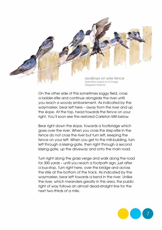
On the other side of this sometimes soggy field, cross a ladder-stile and continue alongside the river until you reach a woody embankment. As indicated by the waymarker, bear left here – away from the river and up the slope. At the top, head towards the fence on your right. You’ll soon see the restored Carleton Mill below.
Bear right down the slope, towards a footbridge which goes over the river. When you cross the step-stile in the fence do not cross the river but turn left, keeping the fence on your left. When you get to the mill-building, turn left through a kissing-gate, then right through a second kissing-gate, up the driveway and onto the main road.
Turn right along the grass verge and walk along the road for 300 yards – until you reach a footpath sign, just after a bus-stop. Turn right here, over the bridge and across the stile at the bottom of the track. As indicated by the waymarker, bear left towards a bend in the river. Unlike the river, which meanders greatly in this area, the public right of way follows an almost dead-straight line for the next two-thirds of a mile.
swallows on wire fenceillustration based on © image Margaret Holland

Bronze panel idea: stoat
8
You are currently on the route of the Miller’s Way, a 51-mile trail from Kendal to Carlisle that was opened in 2006 to mark the 175th anniversary of John Dodgson Carr’s historic trek. This young, progressive baker established one of the world’s most famous flour, bread and biscuit firms in the border city. Rejecting traditional wind and water-powered millstones, he adopted steam technology, pushing the firm to the forefront of milling technology. A Quaker and a radical, Carr also supported the repeal of the Corn Laws and built a school and homes for his workers. The original Carr’s biscuit factory is now McVitie’s, on Caldewgate in the city.
Wreay woods
9
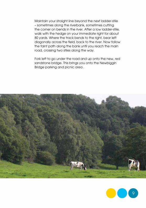
Maintain your straight line beyond the next ladder-stile – sometimes along the riverbank, sometimes cutting the corner on bends in the river. After a low ladder-stile, walk with the hedge on your immediate right for about 80 yards. Where the track bends to the right, bear left diagonally across the field, back to the river. Now follow the faint path along the bank until you reach the main road, crossing two stiles along the way.
Fork left to go under the road and up onto the new, red sandstone bridge. This brings you onto the Newbiggin Bridge parking and picnic area .

10
Wreay Loop
From the picnic area, go through the kissing-gate facing the motorway. Rejoin the riverside path, now walking with the Petteril on your right. Immediately after passing under the motorway, go through a metal kissing-gate. The path splits here. Take the right-hand fork, continuing alongside the river.
Enter some sparse woodland at a metal kissing-gate. Walk through the woodland alongside the river to another metal kissing -gate, ignoring a track heading uphill to the left. Keep close to the water’s edge as you cross the next area of open ground. Once through another kissing-gate and over a wooden footbridge, you enter Wreay Woods.
The woods are owned by Carlisle City Council and managed as a nature reserve by Cumbria Wildlife Trust. Woodland is thought to have existed along this red sandstone gorge since medieval times, although the current species owe more to the felling and planting that took place between 1965 and 1973. Willow and alder, tolerant of waterlogged areas, grow on the banks. In the early morning and at dusk, watch for otters laying up in the cavities between their roots.
otterillustration based on © image Heather Angel (naturalvisions.co.uk)

11
Wreay woods

12
oystercatchers feeding in the river
river wildlife
Cumbria’s many becks and rivers provide food and shelter for a rich range of wildlife.In the upper reaches of a river, salmon and sea trout lay their eggs, and upland birds such as harriers and dipper can be found nearby. Where the river deepens, insects flourish, providing food for a huge range of birds. Songbirds will take them from the ground, ducks can dive for them, waders will walk along the banks and shores picking at them, while sand martin and kingfisher will skim the water’s surface, snapping up insects as they fly.Otters are on the increase in Cumbria, particularly along the river Eden and its tributaries, but also along the river Lune. Weasel, stoat, mink, badger and red squirrel are all found in the fields and woodland fringing the banks; and water vole – the UK’s fastest declining mammal - can still be spotted in the Pennines.

13
The woodland and river habitats attract a range of birds, including kingfisher, grey wagtail, long-tailed tit, dipper and great spotted woodpecker. In winter, siskin and the increasingly rare redpoll can be seen in the alders. Come the summer and blackcap, spotted flycatcher, garden warbler and chiffchaff fly in. The woods are also frequented by red squirrel and roe deer.
grey wagtailillustration based on © image Mike Lane (rspb-images.com)

great spotted woodpeckerillustration based on © image Roger Wilmshurst (rspb-images.com)
14
The path is muddy in places as you make your way through this peaceful, woody gorge, but there are planks over the soggiest patches. Where the path climbs away from the river for a short while, you will encounter another public right of way coming in from the left. Bear right here – downhill.

15
Wreay gorge

16
Pennine fells beyond Wreay Hall Mill
17
The path up to the left leads to Scalesceugh Hall. Built in 1684, it is now a residential home owned by Cumbria Cerebral Palsy. It was once the site of a Roman military tile works, located close to the Romans’ York to Carlisle road. Park House Farm, located on a small hill on the opposite side of the river, was also occupied by the Romans. A fort was discovered here in the late 1940s, a mile or so south at Wreay Hall, there is evidence of a 4th century Roman signal station.
Once over the next footbridge, go through a kissing-gate to leave the nature reserve. The woodland continues and you walk along a pleasant, rhododendron-fringed path. Leaving the woods via a wooden kissing-gate, head for the green, metal footbridge to the right and cross the river. On the west bank, bear half-left across the field – towards a bend in the river. You can just see Wreay Hall Mill on the opposite bank.

18
When you reach a footpath sign beside a fence, turn right - away from the river - to walk uphill with the fence on your left. Cross the wooden step-stile and then continue uphill – more steeply now – alongside the fence. At the top, cross the ladder-stile and turn left along the surfaced lane.
Continue along the lane which crosses the railway until you get to the road. At the road, the main route turns right. However, a short detour into Wreay, particularly to visit its unusual church, is highly recommended.
detail of lotus flower from Wreay Church

19
view over Wreay Woods

20
Shaped like a Roman basilica, St Mary’s Church was built and paid for by local amateur architect, Sara Losh, in 1840-42. Sara was the daughter of a forward-thinking industrial chemist, a friend of William Wordsworth. Her brother being disabled, she was brought up as her father’s heir and received a well-rounded education – something which she put to good use when designing the church in memory of her sister. The highly original building features crocodile gargoyles, an Italian green marble altar, an apse surrounded by an arcade of 14 pillars, and a multitude of carvings. Outside is a replica of the Bewcastle Cross.
replica of Bewcastle Cross (detail)

21
The name Wreay probably comes from a Norse word meaning “bend in the river”. Its site is based on an aquifer that has been used since at least Roman times. Excavations in the churchyard uncovered a tiled watercourse that once took the water all the way to Carlisle Cathedral.
Village records go back to 1319. Wreay is famous for its Twelve Men – a self-electing body dating back to 1664 that was responsible for the welfare of villagers. The original 12 were farmers and landowners worried about the state of the village chapel. They gave some of their rents for its repair. Although they now have few powers, Wreay’s Twelve Men continue to meet once a year, having their traditional supper in the Plough Inn on Candlemas Day.
Sara
Lo
sh

22
Back on the main route, the road heads downhill and under the motorway. Just after passing the Low Hurst compound, turn right along a wide track with a footpath signposted to Golden Fleece.
Low Hurst was a storage site for the Royal Air Force in World War Two; today, it is where the Highways Agency stockpiles grit for de-icing the motorway and local trunk roads in the winter.
Cross the step-stile beside the large metal gate and then turn right to walk alongside the compound’s metal railings. On reaching the fence at the top of the motorway embankment, turn sharp left and then left again at the railway. Now head down into the field corner to cross the boundary fence via a stone-stepped stile.
Head down beside the railway embankment to cross Woodside Beck via a wooden board walk and footbridge. As you head up the next section of path, alongside the railway line, watch for a waymarker on a tree. This indicates that the path heads up to the right to follow the line of a fence.
Cross the footbridge over the railway. Once through the gate on the other side, ignore the metal gate on your right and head up the field with the fence/hedge on your right – away from the railway. Cross the step-stile to the right of the large wooden gate and then walk along the lane serving Newbiggin Hall.
Newbiggin Hall was built as a pele tower in 1304, providing refuge from feuding border clans. Most of the house that you see today dates from the 17th and 18th centuries.

23
wooden door, Wreay Church

24
Keep straight ahead where the lane swings round to the left. Follow the old road, using the gap beside the metal barrier-gate, and cross the recently rebuilt Newbiggin footbridge to return to the parking area.
To walk back to Carlisle, do not cross the bridge but return down the steps on your left and retrace your route.

‘Discover Eden’ is a countryside recreation and interpretation programme being managed by East Cumbria Countryside Project in partnership with the Eden Rivers Trust supported by the Heritage Lottery Fund.
Fourteen circuital routes at dispersed locations throughout East Cumbria provide an opportunity to explore the great scenic diversity associated with the Eden catchment landscape.
Each route is well way-marked with arrows and the distinctive ‘Discover Eden’ kingfisher logo. Watch out for a series of small bronze panels etched with motifs depicting aspects of human and natural heritage. Rubbings can be taken from these using paper and crayon.
By walking all routes you can eventually collect rubbings of eighty four images.
Brief route details:Linear routeThe walk starts from near the Swallow Hilltop Hotel, just off London Road in Carlisle, which is accessible by public transport.Length: 3 miles 9.8 kilometres 1¼ – 1½ hours Grade: easy/moderate with stilesRoute: follows river Petteril from Harraby Green
– Newbiggin Bridge;Wreay extension Parking: for the circular walk is at the picnic area
at Newbiggin Bridge, just south of the Golden Fleece roundabout
Length: 4¼ miles 13.9 kilometres (allow an additional 2 – 2½ hours for the Wreay loop)
Grade: moderate with stilesRoute: Newbiggin Bridge – Wreay Woods – Wreay
village – Newbiggin Hall – Newbiggin BridgeReturn: bus 101 from Rockcliffe to Carlisle
(via Cargo and Stanwix)Clothing: boots and outdoor clothing; paths can be wet
bronze motifs by Pip Hall
research and text by Vivienne Crowimages by Barry Stacy, Val Corbett and ECCP inside flap1. River Eamont 2. Mayburgh Henge 3. Red River benchmark near Temple Sowerby4. Mosedale near Calbeck 5. Haaf netting in Solway 6. Ravenstonedale7. Appleby horse fair 8. River Eden near Wetheral 9. Pendragon Castle
N
HarrabyGreen
Wreay Woods Nature Reserve
GarlandsCarlton
Mill
to town
centre
© Crown copyright. All rights reserved. Licence no. 10000 5056 (2006)
Scale0 1km
0 ½ mile
other paths
footpathbridleway
Swallow Hilltop Hotel
to Dalston
P
Glasgow - Euston (West
Coast m
ainlin
e railw
ay)
Upperby
London Road
Newbiggin BridgeWreay
Gillford Park
Wreay Hall Mill
St Mary’s Church
River Petteril
Low Hurst Depot
Newbiggin Hall
Golden Fleecejunc. 42
M6
A6
A6
to Scotland
to Penrith
to Penrith
Originally published by East Cumbria Countryside Project (c/o Carlisle City Council)
Eden Rivers Trust, Dunmail Building, Newton Rigg College, Penrith. Cumbria CA11 0AH tel: 01768 866788
email: [email protected]
website: edenriverstrust.org.uk
M6
to Wetheral
LOO
K O
UT
for
6 b
ron
ze m
oti
fs •
ch
ildre
n in
wo
rkh
ou
se •
ba
ker m
aki
ng
bre
ad
• m
ea
nd
erin
g ri
ver
• s
pa
rrowhawk • Roman mosaic • Wreay church