Embed Size (px)
Citation preview
Advances in Environmental Technology 1 (2017) 11-25
*Corresponding author. Tel: +98 2166956668 E-mail address: [email protected]
Advances in Environmental Technology
journal homepage: http://aet.irost.ir
case study
Using boolean and fuzzy logic combined with analytic hierarchy process for hazardous waste landfill site selection: A case study from Hormozgan province, Iran
Mahdieh Saadat Foomani, Saeed Karimi*, Hamidreza Jafari, Zahra Ghorbaninia
Department of Environmental Planning, Management and Education, University of Tehran, Tehran, Iran
A R T I C L E I N F O A B S T R A C T
Article history: Received 9 September 2016 Received in revised form 3 March 2017 Accepted 11 June 2017
Hazardous wastes include numerous kinds of discarded chemicals and other wastes generated from industrial, commercial, and institutional activities. These types of waste present immediate or long-term risks to humans, animals, plants, or the environment and therefore require special handling for safe disposal. Landfills that can accept hazardous wastes are excavated or engineered sites where these special types of waste can be disposed of securely. Since landfills are permanent sites, special attention must be afforded in selecting the location. This paper investigated the use of the Boolean theory and Fuzzy logic in combination with Analytic Hierarchy Process (AHP) methods by applying GIS and IDRISI software for the selection of a hazardous waste landfill site in the Iranian province of Hormozgan. The best location was determined via the Fuzzy and the Boolean methodologies. By collating the area selected for the hazardous waste landfill, this study found that Fuzzy logic with an AND operator had the best options for this purpose. In the end, the most suitable area for a hazardous waste landfill was about 1.6 km2 which was obtained by employing Fuzzy in combination with AHP and by using an AND operator. In addition, all the fundamental criteria affecting the landfill location were considered.
Keywords: Hazardous waste Landfill sitting Analytic Hierarchy Process Fuzzy logic Waste management
DOI: 10.22104/aet.2017.502
1. Introduction
Hazardous waste are wastes which are difficult or dangerous to treat, store, or dispose of because they may contain substances which are toxic, reactive, corrosive, infectious, irritant or otherwise harmful to public health and the environment. Various methods such as thermal, biological, off-shore and underground storage, physicochemical, and landfill are available for the treatment and disposal of hazardous wastes, but the chosen method is dependent on the type of waste [1]. A landfill is the final and vital step of an effective waste plan in any area. The landfill siting process aims to locate the areas that will minimize hazards to public health and the environment as well as being cost efficient [2]. Landfill siting is a complex process involving social, environmental
and technical parameters as well as government regulations [3]. If landfills do not meet high standards, they will have a harmful impact on the environment. Therefore, the suitable siting of landfills becomes one of the important tasks involved in waste management planning [4]. The landfill siting procedure has always been a difficult and complicated process because of the conflicts that arise among the various parameters [2]. There are wide ranges of techniques for landfill siting which use different methods to find suitable locations for such installations. In most of the literature for these kinds of studies, the geographic information system (GIS) technique is ideal because of its ability to manage large volumes of spatial data from a variety of sources [2,3,5-8]. It plays a principal role as a decision supporting tool with reference to best site locations [9]. GIS combines spatial data (satellite
M. S. Foomani et al. / Advances in Environmental Technology 1 (2017) 11-25 12
images, aerial photographs, and maps) with qualitative, quantitative, and descriptive information databases, which can support a wide range of spatial queries. All of these factors have made GIS an essential tool for location studies, particularly for landfill siting [10-13]. The integration of GIS and multiple criteria analysis (MCA) can be a powerful tool in the successful selection of a landfill site because GIS provides for efficient manipulation and presentation of the data and MCA supplies consistent ranking of the potential landfill areas based on a variety of criteria [1,14]. Multi-criteria Decision Analysis (MCDA) has the ability of blending expert opinion with factual information [15]. A GIS-based MCDA is a smart system that uses and converts spatial and non-spatial data into beneficial information which in addition to the judgment of the decision maker can be utilized to make critical decisions [6,16]. This technique evaluates varied criteria, conflicting objectives and all possible outcomes that arise from the analysis [17]. GIS has been combined with a decision–making method based on the analytic hierarchy process (AHP) to identify and rank potential landfill areas [18]. In some researches, Fuzzy inference systems have also been proposed to evaluate the result of the site selection [19,20]. In Thailand, Fuzzy set theory with GIS were used for the screening of landfill sites [19]. Combining GIS and Fuzzy multi-criteria decision making were utilized for landfill siting in Harlingen [21]. The Iranian Department of Environment (DOE) sponsored a series of landfill siting projects in various parts of the
country as a strategic national planning tool for the management of hazardous and non-hazardous wastes, [22]. This department is responsible for managing the construction of engineered landfills for hazardous wastes in 30 provinces in Iran [1]. For instance, the site selection for hazardous waste landfills for Zanjan, Qazvin, Kurdistan, and Khorasan Razavi provinces has been reported [1,22-24]. The aim of this article was to site hazardous waste landfill locations for Hormozgan Province in southern Iran. We used two different methods for selecting the location: Fuzzy Logic combined with AHP and Boolean theory. Subsequently, we compared them to determine which method was more efficient.
2. Methodology
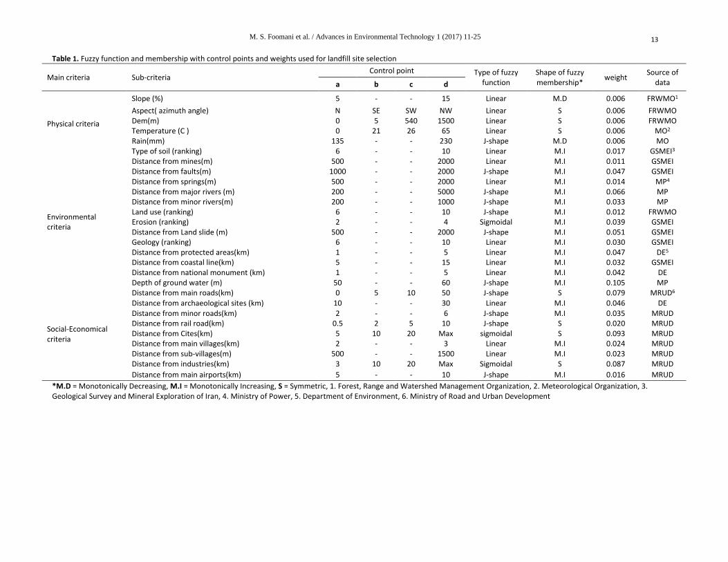
This research considered various criteria by combining an intensive literature review and expert knowledge to determine the best area for a landfill. The criteria were classified into three main clusters: environmental, physical and social-economical. Sub-criteria, according to their characteristics and properties, were grouped as the subset of the main criteria (Table 1). The main criteria and sub-criteria have also been mentioned in the study's Schematic diagram (Figure 2). The siting of a hazardous wastes landfill requires an extensive evaluation process in order to identify the optimum available disposal location. Many factors must be considered while assessing a site as a possible location for a hazardous waste landfill [18].
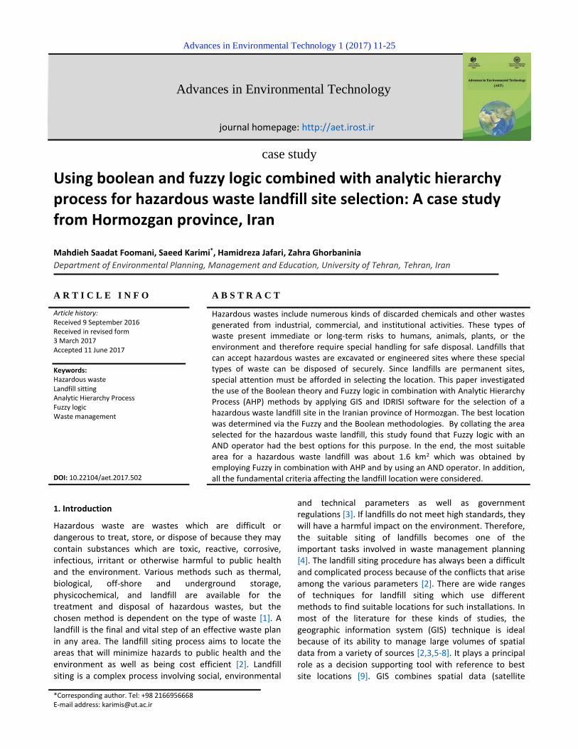
Fig. 1. Location of study area
M. S. Foomani et al. / Advances in Environmental Technology 1 (2017) 11-25
13
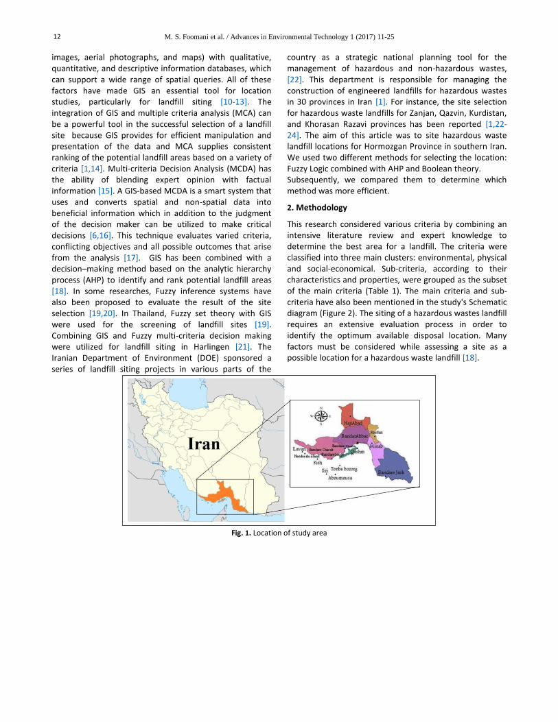
Table 1. Fuzzy function and membership with control points and weights used for landfill site selection
Main criteria Sub-criteria Control point Type of fuzzy
function Shape of fuzzy membership*
weight Source of
data a b c d
Physical criteria
Slope (%) 5 - - 15 Linear M.D 0.006 FRWMO1
Aspect( azimuth angle) N SE SW NW Linear S 0.006 FRWMO Dem(m) 0 5 540 1500 Linear S 0.006 FRWMO Temperature (C ) 0 21 26 65 Linear S 0.006 MO2 Rain(mm) 135 - - 230 J-shape M.D 0.006 MO Type of soil (ranking) 6 - - 10 Linear M.I 0.017 GSMEI3
Environmental criteria
Distance from mines(m) 500 - - 2000 Linear M.I 0.011 GSMEI Distance from faults(m) 1000 - - 2000 J-shape M.I 0.047 GSMEI Distance from springs(m) 500 - - 2000 Linear M.I 0.014 MP4 Distance from major rivers (m) 200 - - 5000 J-shape M.I 0.066 MP Distance from minor rivers(m) 200 - - 1000 J-shape M.I 0.033 MP Land use (ranking) 6 - - 10 J-shape M.I 0.012 FRWMO Erosion (ranking) 2 - - 4 Sigmoidal M.I 0.039 GSMEI Distance from Land slide (m) 500 - - 2000 J-shape M.I 0.051 GSMEI Geology (ranking) 6 - - 10 Linear M.I 0.030 GSMEI Distance from protected areas(km) 1 - - 5 Linear M.I 0.047 DE5 Distance from coastal line(km) 5 - - 15 Linear M.I 0.032 GSMEI Distance from national monument (km) 1 - - 5 Linear M.I 0.042 DE Depth of ground water (m) 50 - - 60 J-shape M.I 0.105 MP
Social-Economical criteria
Distance from main roads(km) 0 5 10 50 J-shape S 0.079 MRUD6 Distance from archaeological sites (km) 10 - - 30 Linear M.I 0.046 DE Distance from minor roads(km) 2 - - 6 J-shape M.I 0.035 MRUD Distance from rail road(km) 0.5 2 5 10 J-shape S 0.020 MRUD Distance from Cites(km) 5 10 20 Max sigmoidal S 0.093 MRUD Distance from main villages(km) 2 - - 3 Linear M.I 0.024 MRUD Distance from sub-villages(m) 500 - - 1500 Linear M.I 0.023 MRUD Distance from industries(km) 3 10 20 Max Sigmoidal S 0.087 MRUD
Distance from main airports(km) 5 - - 10 J-shape M.I 0.016 MRUD
*M.D = Monotonically Decreasing, M.I = Monotonically Increasing, S = Symmetric, 1. Forest, Range and Watershed Management Organization, 2. Meteorological Organization, 3. Geological Survey and Mineral Exploration of Iran, 4. Ministry of Power, 5. Department of Environment, 6. Ministry of Road and Urban Development
M. S. Foomani et al. / Advances in Environmental Technology 1 (2017) 11-25 14
Fig. 2. Schematic diagram for applied fuzzy AHP methodology
The methodology used in this study consists of the following steps along with their explanation.
2.1. Study area
Hormozgan province is situated in the south of Iran and to the north of the Persian Gulf. Its area is about 66557 km2 and it is between 25° and 24’ and 57’N and 52° 41’ to 59° 15’ E from the Greenwich meridian (Figure 1). The total population of the province is 7,600,014 with 150,014 families and includes 305,466 people in urban areas, 45, 2724 people in rural areas and 2,224 people who are non-resident. The province of Hormozgan lies in a desert to a semi-desert like region with a warm (hot) and dry climate. The coastal areas experience warm and humid weather in the summer with moderate winters. Rainfall is scant, but humidity along the coastal regions is high. Hormozgan has about 300 industries which generate nearly 2240 tons of
hazardous waste yearly; therefore, siting landfill locations for this volume of waste is vital and necessary.
2.2. Geographic information system (GIS)
A geographic information system (GIS) lets us visualize, question, analyze, and interpret data to understand relationships, patterns, and trends. GIS is the go-to technology for making better decisions about location. Common examples include real estate site selection, route/corridor selection, evacuation planning, conservation, natural resource extraction, etc. Making correct decisions about location is critical to the success of an organization.GIS is becoming essential to understanding what is happening and what will happen in geographic space. Once we understand, we can prescribe action. GIS can relate unrelated information by using location as the key index variable [25]. Locations or extents in the Earth time may be recorded as dates/times of occurrence and x,
Identify the set
of main criteria
and sub-criteria
Social-Economical
criteria
Physical criteria
City
Roads
Railroad
Industrials
Villages
Mail airports
Archaeological
site
Slope
Aspect
Dem
Temperature
Rain
Type of soil
Environmental
criteria
Mines
Faults
Springs
Rivers
Land use
Erosion
Land slide
Geology
Protected area
Coastal line
National monument
Ground water
Standardized
criteria with Fuzzy
Logic
Standardized
criteria with Fuzzy
Logic
Standardized
criteria with Fuzzy
Logic
Overlay
maps (AND)
Landfill suitability map
Weighted (AHP)
+ WLC
Weighted (AHP)
+ WLC
Weighted (AHP)
+ WLC
M. S. Foomani et al. / Advances in Environmental Technology 1 (2017) 11-25
15
y, and z representing longitude, latitude, and elevation, respectively [26]. All Earth-based spatial–temporal location and extent references should be relatable to one another and ultimately to a "real" physical location or extent. This key characteristic of GIS has begun to open new avenues of scientific inquiry [27]. The role of GIS in solid waste management is very significant as many aspects of its planning and operations are highly dependent on spatial data. In general, GIS plays a key role in maintaining account data to facilitate collection operations. In this manner, aspects such as customer service; analyzing optimal locations for transfer stations; planning routes for vehicles transporting waste from residential, commercial and industrial customers to transfer stations and from transfer stations to landfills; locating new landfills; and monitoring the landfill are important. GIS is a tool that not only reduces time and cost of site selection, but also provides a digital data bank for future monitoring program of the site [28].
2.3. Boolean Logic
Another alternative method to determine suitable locations for landfills is Boolean Logic which queries the required data rather than creating a suitability map. Once all the needed datasets (the thematic layers) have been created, all the suitable locations can be found. The simplest and best-known type of GIS model is probably based on Boolean operations. Robinov (1989) introduced the use of Boolean operations for reasoning with geological maps [29]. Actually, the Boolean model contains the logical combination of binary maps resulting from the application of conditional operators [30]. Only one or zero values are assigned to each unit area, specifying whether it is satisfactory or unsatisfactory, respectively Boolean Logic generally applies a binary condition to the inputs and evaluates to a binary condition for the output [29]. There is a number of ways which express the binary condition: "1" and "0", "True" and "False", "yes" and "no”, and "on" and "off.
2.4. Fuzzy Logic
Classic Boolean logic is binary in which a certain element is true or false and an object belongs to a set or it does not. Fuzzy logic was introduced by Zadeh in 1965 and permits the notion of nuance [31]. Apart from being true, a proposition may also be anything from almost true to hardly true [32]. In comparison with the Boolean sets, a fuzzy set does not have sharply defined boundaries [31]. This theory, which is a generalization of classic set theory, allows the membership functions to operate over the range of real numbers (0, 1). The main characteristic of fuzziness is the grouping of individuals into classes that do not have sharply defined boundaries [33]. The uncertain comparison judgment could be represented by the fuzzy number. A triangular fuzzy number is the special class of
fuzzy numbers whose membership is defined by three real numbers, expressed as (1, m, u) [34]. Fuzzy sets are defined according to the fuzzy membership functions. Based on a fuzzy set, A in the society of X, μ A (x) represents the consistency of the x element in the X fuzzy set which can get [35] complete membership, partial membership or no membership (Equation 1).
A = {x. μ A(x) ׀x ε X} (1)
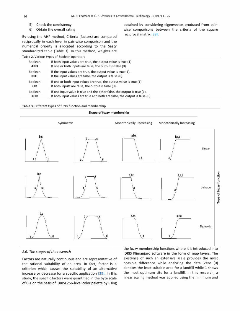
Fuzzy membership functions are linear, S (sigmoid) shape and J shape ones (Table 2). It is also possible to define the fuzzy membership function by the user [35]. The following lists the appropriate Overlay type to use for certain conditions:
Use OR when any of the input evidence rasters can have a high value in order for the output to be a high value.
Use AND when all of the input evidence rasters must have a high value in order for the output to be a high value.
Use PRODUCT when the combined evidence is less important than any single evidence.
Use SUM when the combined evidence is more important than any single evidence.
The GAMMA Overlay type is typically used to combine fuzzy combinations of more basic data. When Gamma is 1, the result is the same as Fuzzy Sum. When Gamma is 0, the result is the same as Fuzzy Product. Values in between allow the user to combine evidence between these two extremes and possibly different than Fuzzy And or Fuzzy Or.
2.5. Analytical Hierarchy Process (AHP)
The AHP is one of the most commonly MCDM techniques incorporated into GIS-based sitting procedures (36). AHP was developed by Satty (1980) to help decision makers arrive at the best decision in a case of multiple conflicting objectives (criteria). It is a flexible decision making tool for multi criteria problems and has been used in this study to determine the relative importance of LSS criteria. The AHP helps decision makers to organize and evaluate the relative importance of selected objectives and the relative importance of alternative solutions. In general, the AHP method is a common decision making technique, which can be used to analyze and support decisions with multiple objectives. In order to achieve this, a complex problem is divided into a number of simpler problems within the hierarchy [5]. The six important steps of the AHP procedure are listed below [37]:
1) Define the unstructured problem 2) Developing the AHP hierarchy 3) Pair-wise comparison 4) Estimate the relative weights
M. S. Foomani et al. / Advances in Environmental Technology 1 (2017) 11-25 16
5) Check the consistency 6) Obtain the overall rating
By using the AHP method, Criteria (factors) are compared reciprocally in each level in pair-wise comparison and the numerical priority is allocated according to the Saaty standardized table (Table 3). In this method, weights are
obtained by considering eigenvector produced from pair-wise comparisons between the criteria of the square reciprocal matrix [38].
Table 2. Various types of Boolean operators
Boolean AND
If both input values are true, the output value is true (1). If one or both inputs are false, the output is false (0).
Boolean NOT
If the input values are true, the output value is true (1). If the input values are false, the output is false (0).
Boolean OR
If one or both input values are true, the output value is true (1). If both inputs are false, the output is false (0).
Boolean XOR
If one input value is true and the other false, the output is true (1). If both input values are true and both are false, the output is false (0).
Table 3. Different types of fuzzy function and membership
Shape of fuzzy membership
Symmetric Monotonically Decreasing Monotonically Increasing
Linear
Typ
e o
f fu
zzy
fun
ctio
n
J-shape
Sigmoidal
2.6. The stages of the research
Factors are naturally continuous and are representative of the rational suitability of an area. In fact, factor is a criterion which causes the suitability of an alternative increase or decrease for a specific application [39]. In this study, the specific factors were quantified in the byte scale of 0-1 on the basis of IDRISI 256-level color palette by using
the fuzzy membership functions where it is introduced into IDRIS Klimanjaro software in the form of map layers. The existence of such an extensive scale provides the most possible difference while analyzing the data. Zero (0) denotes the least suitable area for a landfill while 1 shows the most optimum site for a landfill. In this research, a linear scaling method was applied using the minimum and
M. S. Foomani et al. / Advances in Environmental Technology 1 (2017) 11-25
17
maximum values as scaling points for standardization (Equation 2):
𝑋𝑖 =(𝑅𝑖 − 𝑅𝑚𝑖𝑛)
(𝑅𝑚𝑎𝑥 − 𝑅𝑚𝑖𝑛)∗ 𝑠𝑡𝑎𝑛𝑑𝑎𝑟𝑑𝑖𝑧𝑒𝑑 𝑟𝑎𝑛𝑔𝑒
(2)
where: R= raw score, R min= Minimum score, and R max = Maximum score. After the standardization of all the factors by using the fuzzy membership functions in the byte scale of 0 to 1, a weight was assigned to each factor. This weight was the representative of one factor importance against the other factors. Each factor weight was multiplied by the standardized map (being scaled) of that factor [2]. The mathematical formulation of this method is described as follows (Equation 3): S = ∑ W iX i (3) Suitability Wi= Weight of factor i. Xi= criterion score of factor i. After the weighting of the layers, a suitable means should be selected for combining the layers. In this study, fuzzy overlay was chosen for this action.
2.7. Evaluation criteria
The physical factors are described below: Slope: In general very steep slopes bring higher excavation costs. Therefore, areas with high slope are not considered to be suitable for landfill sites. For the slope, a monotonically decreasing linear shape fuzzy membership function was considered. Thus, according to surveys and studies, 5 and 15% were chosen as the a and b control points for standardization. Topography: Hilly landscapes not only increase construction costs, but also become a burden to vehicles transporting waste to landfill locations since a number of highlands will be difficult to negotiate if proper leveling is not done. A symmetric linear shape fuzzy membership function was considered for the topography. Therefore, according to surveys and studies, the range from 5 to 534-meter altitude was considered as the best range for a hazardous waste landfill. Aspect: The air pollution produced, especially from the methane generated by decomposing degradable materials in a landfill, is a serious concern and as such, much attention has been paid to the wind direction in this research. An aspect map of the study area was derived using digital elevation model data. Wind direction records from the Metrological Organization indicated that north (N) and northwest (NW) were the dominant wind directions. These undesired aspects were assigned lower values while those that do not fall in this category were given higher values. A symmetric linear shape fuzzy membership function was considered for the aspect factor. Soil: The higher the soil permeability, the more probable the pollution of the groundwater by leachate. A geologist ranked the soil classes that were available in this area
according to the degree of appropriateness to construct a suitable location for a landfill. A monotonically increasing linear shape fuzzy membership function was considered for the soil factor. Temperature: Temperature like other factors has a significant role in this study. Because of leachate in landfills and other problems such as bad smells, temperature has a special range. For the temperature factor, a symmetric linear shape fuzzy membership function was considered. The range of 21 to 26 centigrade was considered as the best range for this action. Rain: Rain is another important factor in this study because it enters into the surface waters and affects the transfer of latex. For the rain factor, a monotonically decreasing J shape fuzzy membership function was chosen. According to other studies and expert opinions, precipitation of less than 135 millimeters was selected as the best range for rain. The environmental factors are listed below: Erosion: Erosion as one environmental factor that has an effective role in determining the location of the landfill. In geomorphology and geology, erosion refers to the actions of exogenic processes (such as water flow or wind) which remove soil and rock from one location on the Earth's crust, then transport it to another location where it is deposited. Eroded sediment may be transported just a few millimeters or thousands of kilometers. Accordingly, a geologist has classified the erosion classes from the worst to best. Landslide: A landslide, also known as a landslip, is a geological phenomenon that includes a wide range of ground movements, such as rock falls, deep failure of slopes and shallow debris flows. Landslides can occur in offshore, coastal and onshore environments. Although the action of gravity is the primary driving force for a landslide to occur, there are other contributing factors affecting the original slope stability. Due to that and according to various surveys and studies as well as expert opinions, 500 and 2000 (m) was chosen as the a and b control points. In the J-shape fuzzy function, more than 2000 meter is the best distance from landslides points. Faults: Faults are geological conditions that cause limitation for siting a landfill [35]. As there is no complete and exact information concerning all faults in Iran, the preliminary background lists all the faults in the geology map as active. For this factor, 1000 and 2000 (m) is chosen as the a and b control points with a J-shape fuzzy function. Land use: This criterion is not based on specific directions and may be altered according to the study area [2]. From the stand point of the economy, it is better to choose bare lands which can be used after landfill site completion or can be sold [40]. Due to this situation, land use classes are ranked from worst to best. Geology: The environmental impact of landfill sites has led in recent years to increasing awareness of the geological
M. S. Foomani et al. / Advances in Environmental Technology 1 (2017) 11-25 18
factors in the site selection, especially the potential for pollution. The main geological factors to be considered in landfill-site selection are the depth of the soil and weathered rock as well as the ease of excavation [41]. The geology of an area will directly control the soil types created from the parent material, loading bearing capacity of the landfill’s foundation soil, and the migration of leachate. Rock and its structure type will determine the nature of soils and the permeability of the bedrock. Geologic structure will influence the movement of leachate and potential rock-slope failure along joints and tilted bedding planes [42]. For this purpose, we examined the geological structure of the region to identify details. For example, more area is covered with qft2 structure or we can see Qcf or Qm only in some small parts in the southeast of region. In order to achieve the appropriate structures for the construction of landfill sites, geologists classify geological structures according to the degree of their compatibility. Based on the rankings and surveys conducted by geologists, 6 and 10 categories were chosen as the a and b control points for that and higher than 10 is the most suitable category. Ground water: In areas where solid wastes are put directly on the groundwater table, the groundwater will definitely be polluted. This pollution is caused basically from contact with water and leachate [43]. To protect subsurface drinking water, landfills should not be situated over high quality groundwater resources. Fresh groundwater (total dissolved solids>1000 mg/L) should be avoided or protected with a compound liner system and monitoring wells [44]. In this regard, we reviewed and identified the underground water resources in the area. Accordingly, the maximum dispersion of springs was in the west and southwest region. For the preparation of groundwater limitation, a review of other studies and governmental roles was used and more than 60-meter depth was considered the best range for the depth of ground waters in J-shape fuzzy function. Surface water: This factor is important from both an environmental and economic point of view because in addition to causing pollution problems, it may require an efficient drainage system with high expenses [35]. The landfill site should not be placed within surface water or water resources protection areas to protect surface water from contamination by leachate. Safe distances from meandering and non-meandering rivers should be achieved to prevent waste from eroding into rivers and major streams. If the regional drinking water is supplied by surface water impoundments, it may be necessary to exclude the entire watershed that drains into the reservoir from landfill sites [44]. According to the investigation, the greatest concentration of major rivers are in the southeast and the largest concentration of minor rivers are in the west and southwest. According to a survey carried out by the study of other resources, scientific papers, and review
of the rules and regulations, 200 and 5000 meter was chosen as the a and b control points for major rivers where higher than 5000 meters is the best range for major rivers; 200 and 1000 meter was decided as the a and b control points for minor rivers. Sensitive habitats: This criterion is important because hazard waste landfills can cause degradation and potential pollution to sensitive ecosystems. It has been attempted to conserve the nature of the areas, which are under the management of the Iranian environment department. These areas include national parks, protected areas, wildlife refuges and national monuments. Therefore, some limitations were selected for protected areas, coastal areas and national monuments. These limitations were chosen by considering the laws and governmental roles as well as reviewing other studies and surveys by specialists. One and five kilometers (km) were considered as the a and b control points for protected areas and national monuments; 5 and 15 (km) were considered as the a and b control points for coastal areas in linear fuzzy function. Springs: A spring is a component of the hydrosphere. Specifically, it is any natural situation where water flows to the surface of the earth from underground. Thus, a spring is a site where the aquifer surface meets the ground surface. So this factor has an important role in the site selection of landfills due to access of surface and ground waters and the presence of leachate in landfills. Therefore, using 500 and 2000 (m) as the a and b control points was decided with linear fuzzy function that shows a higher than the upper point of 2000 meter is a good distance from the springs. Mines: The distance of mines in regard to mine safety and the situation of landfills is recommended to observe privacy from landfills. The distance of 500 and 2000 meter as the a and b control points and linear fuzzy function was considered for this factor (The shapes of fuzzy membership for all environmental factors were Monotonically Increasing). The social-economic factors are discussed below: Road network: Building roads for landfill access, especially long distances, requires huge preliminary expenses. So the selected site should be close to highways and main roads (40). In addition, to the given description, it is better landfill sites placed at the right distance from social situations. Therefore, 2 and 6 (km) were chosen as the a and b points for minor roads and 5 to 10 (km) for major roads were selected as the best range. Railroads have a similar situation, so according to various surveys and studies, 2 to 5 (km) was chosen for this kind of transportation. Since major roads and railroads were considered as the main means for waste transportation, a moderate distance from them is desirable so symmetric fuzzy function were selected for them. Residential areas: Landfill sites should be located away and far from populated areas. Otherwise, it causes bad odors and

M. S. Foomani et al. / Advances in Environmental Technology 1 (2017) 11-25
19
depreciation of land in the surrounding area [21]. The sufficient landfill capacity for the city's long term requirements should be considered and the landfill site should not be affected by the development plans of the city (40). Due to its negative effects, 500 and 1500 meters as the a and b control points for sub-villages and 2000 and 3000 meter as the a and b control points for main villages with linear fuzzy function were chosen. Considering the cities as one source of hazardous waste, sigmoidal fuzzy function and symmetric membership was chosen for them. Airport: Landfill sites attract a variety of birds around them. This issue may interfere with the operation of airplanes. Therefore, it is essential to consider a suitable distance from the landfill site according to airport and
airplane types [45]. Thus, 5 and 10 (km) as the a and b control points in J-shape fuzzy function was selected for this factor. Distance from Cultural Heritage Sites: Landfill sites should not be placed on a site close to historical or cultural sites [14]. There are many cultural and archaeological sites that should be protected in Iran. For the study area, 10 and 30 (km) as the a and b control points with linear fuzzy function was decided. Industry: Industries are another source that generates hazardous waste that need to be a logical distance from landfills. For this purpose, a 10 to 30 (km) distance was considered as the best distance; like cities, a sigmoidal and symmetric fuzzy membership were considered.
Fig. 3. Fuzzy standardized maps: (a) Dem; (b) Geology; (c) Land use; and (d) Distance from cities
3. Results and discussion
This study utilizes 28 factors maps including 6 physical maps, 13 environmental maps and 9 social-economical
maps. As shown in Figure 2, the first step is standardizing all factors by Fuzzy Logic according to Table 1. For this purpose, all the maps were standardized into 0-1 byte using the fuzzy module in IDRISI. This means that the areas
M. S. Foomani et al. / Advances in Environmental Technology 1 (2017) 11-25 20
that have poor conditions for landfill were given lower values while those that are supposed to be ideal were given higher values (closer to 1) which indicated more suitability. Figure 3 shows the standardized maps of Dem, Geology, Land use, and Distance from cities as an example of all factors maps, and the same standardized maps were created for other factors too. In the next level, the weight of every factor should be computed. This step used AHP to elicit weights and assign relative importance to the factors. In composing the pairwise matrix of relative factors, which were developed by experts in different fields and using the Expert Choice software, the weights of the factors were generated. The overall inconsistency was 0.09 (OI<0.1) which indicated an accurate consistency of the judgments and reliable results. Considering Table 1, the highest weights were assigned to the groundwater, cites, and industries that were the most important factors for this
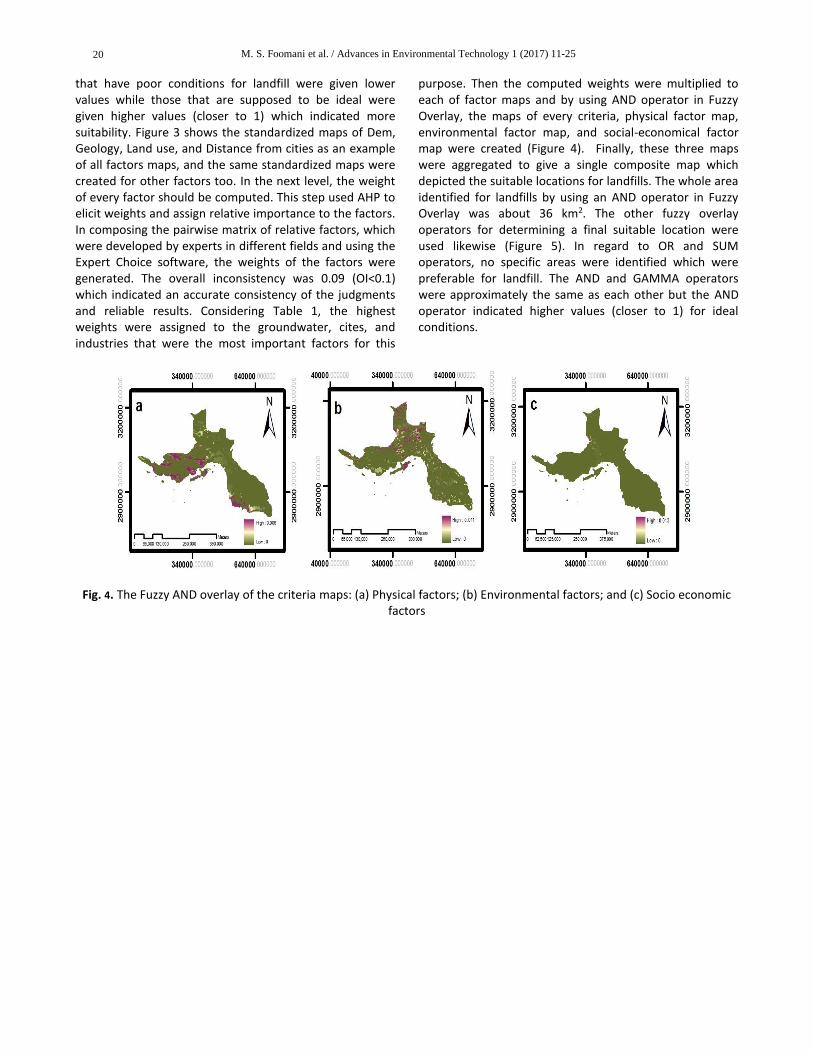
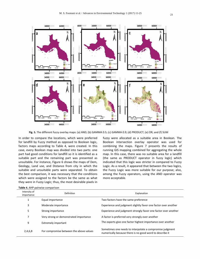
purpose. Then the computed weights were multiplied to each of factor maps and by using AND operator in Fuzzy Overlay, the maps of every criteria, physical factor map, environmental factor map, and social-economical factor map were created (Figure 4). Finally, these three maps were aggregated to give a single composite map which depicted the suitable locations for landfills. The whole area identified for landfills by using an AND operator in Fuzzy Overlay was about 36 km2. The other fuzzy overlay operators for determining a final suitable location were used likewise (Figure 5). In regard to OR and SUM operators, no specific areas were identified which were preferable for landfill. The AND and GAMMA operators were approximately the same as each other but the AND operator indicated higher values (closer to 1) for ideal conditions.
Fig. 4. The Fuzzy AND overlay of the criteria maps: (a) Physical factors; (b) Environmental factors; and (c) Socio economic
factors
M. S. Foomani et al. / Advances in Environmental Technology 1 (2017) 11-25
21
Fig. 5. The different fuzzy overlay maps: (a) AND; (b) GAMMA 0.5; (c) GAMMA 0.9; (d) PRODUCT; (e) OR; and (f) SUM
In order to compare the locations, which were preferred for landfill by Fuzzy method as opposed to Boolean logic, factors maps according to Table 4, were created. In this case, every Boolean map was divided into two parts: one part had good conditions for landfill so it is identified as a suitable part and the remaining part was presented as unsuitable. For instance, Figure 6 shows the maps of Dem, Geology, Land use, and Distance from city in which the suitable and unsuitable parts were separated. To obtain the best comparison, it was necessary that the conditions which were assigned to the factors be the same as what they were in Fuzzy Logic; thus, the most desirable pixels in
fuzzy were allocated as a suitable area in Boolean. The Boolean intersection overlay operator was used for combining the maps. Figure 7 presents the results of running GIS mapping combined for aggregating the whole map. In this case, there was no suitable area for a landfill (the same as PRODUCT operator in fuzzy logic) which indicated that this logic was stricter in compared to Fuzzy Logic. As a result, it appeared that between the two logics, the Fuzzy Logic was more suitable for our purpose; also, among the Fuzzy operators, using the AND operator was more acceptable.
Table 4. AHP pairwise comparison
Intensity of importance
Definition Explanation
1 Equal importance Two factors have the same preference
3 Moderate importance Experience and judgment slightly favor one factor over another
5 Strong importance Experience and judgment strongly favor one factor over another
7 Very strong or demonstrated importance A factor is preferred very strongly over another
9 Extremely important The experts give one factor highest importance over another
2,4,6,8 For compromise between the above values Sometimes one needs to interpolate a compromise judgment numerically because there is no good word to describe it

M. S. Foomani et al. / Advances in Environmental Technology 1 (2017) 11-25 22
Fig. 6. Maps produced by Boolean logic: (a) Dem; (b) Geology; (c) Land use; and (d) Distance from cities
Fig. 7. Final map using the Boolean method
Fig. 8. Result: the suggested site
M. S. Foomani et al. / Advances in Environmental Technology 1 (2017) 11-25
23
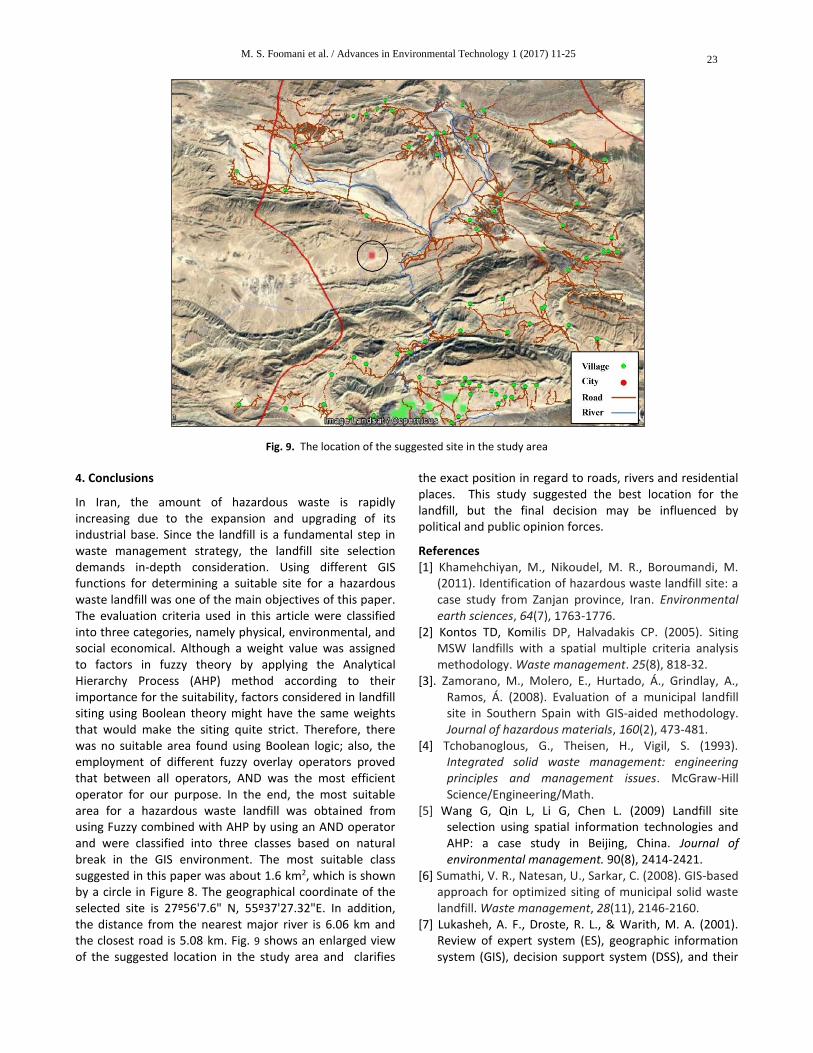
Fig. 9. The location of the suggested site in the study area
4. Conclusions
In Iran, the amount of hazardous waste is rapidly increasing due to the expansion and upgrading of its industrial base. Since the landfill is a fundamental step in waste management strategy, the landfill site selection demands in-depth consideration. Using different GIS functions for determining a suitable site for a hazardous waste landfill was one of the main objectives of this paper. The evaluation criteria used in this article were classified into three categories, namely physical, environmental, and social economical. Although a weight value was assigned to factors in fuzzy theory by applying the Analytical Hierarchy Process (AHP) method according to their importance for the suitability, factors considered in landfill siting using Boolean theory might have the same weights that would make the siting quite strict. Therefore, there was no suitable area found using Boolean logic; also, the employment of different fuzzy overlay operators proved that between all operators, AND was the most efficient operator for our purpose. In the end, the most suitable area for a hazardous waste landfill was obtained from using Fuzzy combined with AHP by using an AND operator and were classified into three classes based on natural break in the GIS environment. The most suitable class suggested in this paper was about 1.6 km2, which is shown by a circle in Figure 8. The geographical coordinate of the selected site is 27º56'7.6" N, 55º37'27.32"E. In addition, the distance from the nearest major river is 6.06 km and the closest road is 5.08 km. Fig. 9 shows an enlarged view of the suggested location in the study area and clarifies
the exact position in regard to roads, rivers and residential places. This study suggested the best location for the landfill, but the final decision may be influenced by political and public opinion forces.
References [1] Khamehchiyan, M., Nikoudel, M. R., Boroumandi, M.
(2011). Identification of hazardous waste landfill site: a case study from Zanjan province, Iran. Environmental earth sciences, 64(7), 1763-1776.
[2] Kontos TD, Komilis DP, Halvadakis CP. (2005). Siting MSW landfills with a spatial multiple criteria analysis methodology. Waste management. 25(8), 818-32.
[3]. Zamorano, M., Molero, E., Hurtado, Á., Grindlay, A., Ramos, Á. (2008). Evaluation of a municipal landfill site in Southern Spain with GIS-aided methodology. Journal of hazardous materials, 160(2), 473-481.
[4] Tchobanoglous, G., Theisen, H., Vigil, S. (1993). Integrated solid waste management: engineering principles and management issues. McGraw-Hill Science/Engineering/Math.
[5] Wang G, Qin L, Li G, Chen L. (2009) Landfill site selection using spatial information technologies and AHP: a case study in Beijing, China. Journal of environmental management. 90(8), 2414-2421.
[6] Sumathi, V. R., Natesan, U., Sarkar, C. (2008). GIS-based approach for optimized siting of municipal solid waste landfill. Waste management, 28(11), 2146-2160.
[7] Lukasheh, A. F., Droste, R. L., & Warith, M. A. (2001). Review of expert system (ES), geographic information system (GIS), decision support system (DSS), and their

M. S. Foomani et al. / Advances in Environmental Technology 1 (2017) 11-25 24
applications in landfill design and management. Waste Management & Research, 19(2), 177-185.
[8] Javaheri, H., Nasrabadi, T., Jafarian, M. H., Rowshan, G. R., Khoshnam, H. (2006). Site selection of municipal solid waste landfills using analytical hierarchy process method in a geographical information technology environment in Giroft. Journal of environmental health science and engineering, 3(3), 177-184.
[9] Baban, S. M., Flannagan, J. (1998). Developing and implementing GIS-assisted constraints criteria for planning landfill sites in the UK. Planning practice and research, 13(2), 139-151.
[10] Church, R. L. (2002). Geographical information systems and location science. Computers and operations research, 29(6), 541-562.
[11] Chaudhary, P., Chhetri, S. K., Joshi, K. M., Shrestha, B. M., Kayastha, P. (2016). Application of an Analytic Hierarchy Process (AHP) in the GIS interface for suitable fire site selection: A case study from Kathmandu Metropolitan City, Nepal. Socio-economic planning sciences, 53, 60-71.
[12] Kumar, S., Bansal, V. K. (2016). A GIS-based methodology for safe site selection of a building in a hilly region. Frontiers of architectural research,5(1), 39-51.
[13] Vasileiou, M., Loukogeorgaki, E., Vagiona, D. G. (2017). GIS-based multi-criteria decision analysis for site selection of hybrid offshore wind and wave energy systems in Greece. Renewable and sustainable energy reviews, 73, 745-757.
[14] Nas, B., Cay, T., Iscan, F., Berktay, A. (2010). Selection of MSW landfill site for Konya, Turkey using GIS and multi-criteria evaluation. Environmental monitoring and assessment, 160(1), 491-500.
[15] Geneletti, D. (2010). Combining stakeholder analysis and spatial multicriteria evaluation to select and rank inert landfill sites. Waste management, 30(2), 328-337.
[16] Chen, Y., Yu, J., Khan, S. (2010). Spatial sensitivity analysis of multi-criteria weights in GIS-based land suitability evaluation. Environmental modelling and software, 25(12), 1582-1591.
[17] Al-Hanbali, A., Alsaaideh, B., Kondoh, A. (2011). Using GIS-based weighted linear combination analysis and remote sensing techniques to select optimum solid waste disposal sites within Mafraq City, Jordan. Journal of geographic information system, 3, 267-278.
[18] Siddiqui, M. Z., Everett, J. W., Vieux, B. E. (1996). Landfill siting using geographic information systems: a demonstration. Journal of environmental engineering, 122(6), 515-523.
[19] Charnpratheep, K., Zhou, Q., Garner, B. (1997). Preliminary landfill site screening using fuzzy geographical information systems. Waste management and research, 15(2), 197-215.
[20] Al-Jarrah, O., Abu-Qdais, H. (2006). Municipal solid waste landfill siting using intelligent system. Waste management, 26(3), 299-306.
[21] Chang, N. B., Parvathinathan, G., Breeden, J. B. (2008). Combining GIS with fuzzy multicriteria decision-making for landfill siting in a fast-growing urban region. Journal of environmental management, 87(1), 139-153.
[22] Sharifi, M., Hadidi, M., Vessali, E., Mosstafakhani, P., Taheri, K., Shahoie, S., Khodamoradpour, M. (2009). Integrating multi-criteria decision analysis for a GIS-based hazardous waste landfill sitting in Kurdistan Province, western Iran. Waste management, 29(10), 2740-2758
[23] Moghaddas, N. H., & Namaghi, H. H. (2011). Hazardous waste landfill site selection in Khorasan Razavi province, northeastern Iran. Arabian journal of geosciences, 4(1-2), 103-113.
[24] Abessi, O., Saeedi, M. (2010). Hazardous waste landfill siting using GIS technique and analytical hierarchy process. Environment Asia, 3(2), 47-53.
[25] Clarke, K. C. (1986). Advances in geographic information systems.Computers, environment and urban systems, 10(3-4), 175-184.
[26] Maliene, V., Grigonis, V., Palevicius, V., Griffiths, S. (2011). Geographic information system: Old principles with new capabilities. Urban Design International, 16(1), 1-6.
[27] Goodchild, M. F. (2010). Twenty years of progress: GIScience in 2010. Journal of Spatial Information Science, 1, 3-20.
[28] Tomlinson, R. F. (1987). Current and potential uses of geographical information systems The North American experience. International journal of geographical information system, 1(3), 203-218.
[29] Bhowmick, P., Mukhopadhyay, S., Sivakumar, V. (2014). A review on GIS based Fuzzy and Boolean logic modelling approach to identify the suitable sites for Artificial Recharge of Groundwater. Scholars Journal of engineering and technology, 2, 316-319.
[30] Bonham-Carter, G. F. (1994). Geographic information systems for geoscientists-modeling with GIS. Pergamon Press, New York.
[31] Karkazi, A., Hatzichristos, T., Emmanouilidi, B., & Mavropoulos, A. (2001). Landfill siting using GIS and Fuzzy Logic. In proceedings of the 8th international waste management and landfill symposium.
[32] Kosko B. (1993) Fuzzy thinking: the new science of fuzzy logic, Hyperion, New York.
[33] Hansen, H. S. (2005) GIS-based multi-criteria analysis of wind farm development. In ScanGIS 2005: Scandinavian Research Conference on Geographical Information Science.
[34] Thalia S, Tuteja A, Dutta M. 2011. Towards quantification of information system security.
M. S. Foomani et al. / Advances in Environmental Technology 1 (2017) 11-25
25
Computational intelligence and information technology: Springer; p. 225-31.
[35] Gemitzi, A., Tsihrintzis, V. A., Voudrias, E., Petalas, C., Stravodimos, G. (2007). Combining geographic information system, multicriteria evaluation techniques and fuzzy logic in siting MSW landfills. Environmental geology, 51(5), 797-811.
[36] Mosadeghi, R., Warnken, J., Tomlinson, R., Mirfenderesk, H. (2015). Comparison of Fuzzy-AHP and AHP in a spatial multi-criteria decision making model for urban land-use planning. Computers, Environment and urban systems, 49, 54-65.
[37] Lee, A. H., Chen, W. C., & Chang, C. J. (2008). A fuzzy AHP and BSC approach for evaluating performance of IT department in the manufacturing industry in Taiwan. Expert systems with applications, 34, 96-107.
[38] Saaty, T. L. (2008). Decision making with the analytic hierarchy process. International journal of services sciences, 1(1), 83-98.
[39] Mahini, A. S., Gholamalifard, M. (2006). Siting MSW landfills with a weighted linear combination methodology in a GIS environment. International journal of environmental science and technology, 3(4), 435-445.
[40] Abdoli MA. (1993) Municipal solid waste management system and its control methods. Metropolitan recycling organization publication, 142-154.
[41] Jacobson, G., Evans, W. R. (1981). Geological factors in the development of sanitary landfill sites in the Australian Capital Territory. BMR journal of Australian geology geophysics, 6, 31-41.
[42] Knight, M. J., Leonard, J. G., Whiteley, R. J. (1978). Lucas heights solid waste landfill and downstream leachate transport—a case study in environmental geology. Bulletin of the international association of engineering geology-bulletin de l'association internationale de géologie de l'ingénieur,18(1), 45-64.
[43] Soupios, P., Papadopoulos, N., Papadopoulos, I., Kouli, M., Vallianatos, F., Sarris, A., Manios, T. (2007). Application of integrated methods in mapping waste disposal areas. Environmental geology, 53, 661-675.
[44] Bagchi, A. (1994) Design, Construction and Monitoring of Landfills. 2nd Edition, John Wiley & Sons, Inc., New York.
[45] Daneshvar, R. (2004). Customizing arcmap interface to generate a user-friendly landfill site selection GIS tool (Doctoral dissertation, University of Ottawa (Canada)).