Embed Size (px)
Citation preview

a
CASE STUDY
Stream EM survey –Tank Farm

Stream EM survey in tanks farmDukhan - Qatar
• The Stream EM survey was performed in a Tank Farm used to store the fresh water for the city of Dukhan - Qatar.
• The growing of the city is related to the increasing of the fresh water needs, so the local authority planned the expansion of the existing tanks farm, with the construction of new tanks to increase the water storage capability.
• The map of the existing buried utilities in the entire farm was required before the starting of the construction of the new structures.
• The mapping project was performed by the company IMG Srl(Italy) in cooperation with the Qatari company Al Mustafawi.
Stream EM survey in tank farmDukhan - Qatar

• The GPR survey was included in the project for Qatar Petroleum for the construction of an Additional Water Storage at Jabel Tank Farm, Dukhan.
• Below the details of the complete project in which the utility mapping by GPR is included:
• Client: Qatar Petroleum
• Year: 2014 – 2016
• Type: Construction Project
• Project Details :
▪ demolition of 2 existing tanks;
▪ construction of 2 new tanks;
▪ construction of platforms and handrails;
▪ construction of piping works and pipe supports;
▪ carrying out foundation work of portable water tanks;
▪ carrying out construction of retaining wall;
▪ relocation of fire water pump and related works;
▪ electrical and instrumentation works.
▪ pre-commissioning and commissioning works.
Stream EM survey in tank farmDukhan - Qatar

Dukhan City plan and tanks farm (in red)
Stream EM survey in tank farmDukhan - Qatar
Tank farm

Survey by Stream EM
Transportation of the system to Dukhan Stream EM set up and RTK-GPS installation
Stream EM survey in tank farmSurvey set up

RIS MF Hi-Mod with #4 dualfrequency antennas to coverareas with limited access
Stream X configuration used for off road survey
Stream EM survey in tank farmSystem modularity
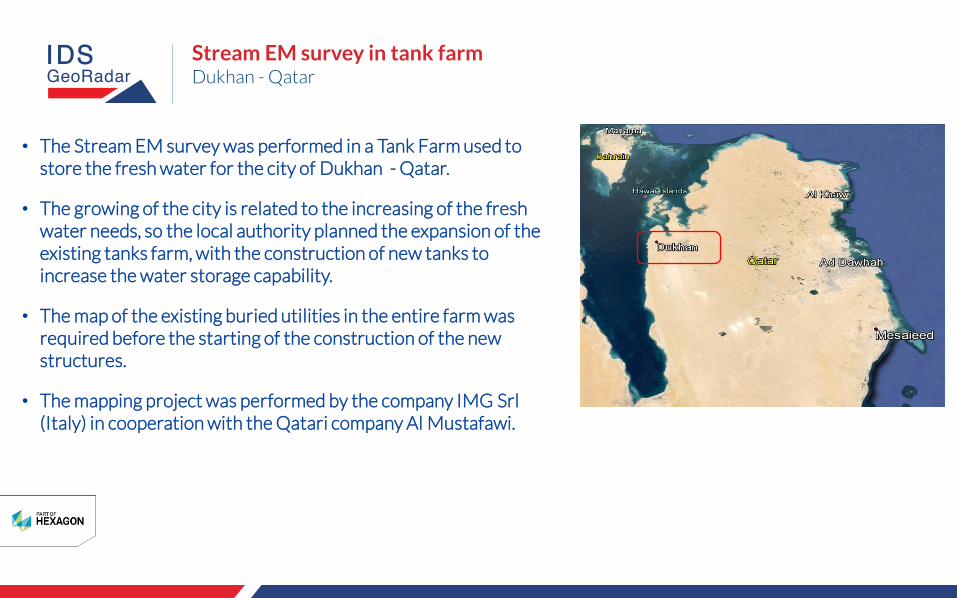
Soil section of the area showing clay-stone levels and silt level with high content of salt (critical condition for GPR survey)
Excavations showing the existing utilities
Stream EM survey in tank farmSite information

• The area interested by the GPR survey had a total extension of around 40.000 sqm partially covered by existing structures.
• The survey was performed by:
▪ Stream EM on roads and flat area;
▪ Stream X on rough surface;
▪ RIS MF Hi-Mod#4 on the area where it was not possible to drive a vehicle.
• Survey time with total GPR coverage: 1 day
• Processing time and results presentation: 2 days
Stream EM survey path
Stream X survey path
Stream EM survey in tank farmSite information

GPR data collection has been performed thanks to IDS GeoRadar OneVision software allowing real time 3D Radar tomography, real time target viewing and integrated GPS navigation on Google Map.
Pipes
Stream EM survey in tank farmData acquisition

Stream EM survey in tank farmData acquisition
OneVision software allows to insert directly on site targets during the acquisition phase.

Stream EM survey in tank farmData acquisition
OneVision software allows to insert directly on site targets during the acquisition phase.

GRED HD 3D CAD showing 3D radar tomography (time slices) with pipes (red circles).
Stream EM survey in tank farmData processing

GRED HD 3D CAD showing 3D radar tomography with manhole covers (orange spots).
Stream EM survey in tank farmData processing

Stream EM survey in tank farmData processing
GRED HD 3D CAD showing 3D radar tomography with buried circular structures (red circles) - old tanks?

AutoCad map of the complete area interested by GPR survey
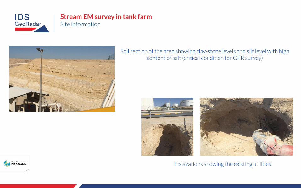
The final results with detected pipes and cables directly exported in AutoCad software.
Stream EM survey in tank farmResults

AutoCad map: utility network showing main pipes (pink) and some smaller connections (blue)
Stream EM survey in tank farmResults
The final results with detected pipes and cables directly exported in AutoCad software.
The final results with detected pipes and cables directly exported in AutoCad software.
AutoCad map: zoom with main pipes (pink) and some smaller connections (blue).
Stream EM survey in tank farmResults

The final results with detected pipes and cables directly exported in AutoCad software.
AutoCad map: zoom with main pipes (pink) and some smaller connections (blue).
Stream EM survey in tank farmResults

• Dense array of antennas towed by vehicle, represents the unique solution suitable for fast mapping on large areas.
• Stream EM features (dense data spacing, dual frequency antennas 200-600 MHz, dual polarization antennas) allows the accurate mapping of the buried utilities.
• Despite the critical soil conditions for GPR survey (high level of clay and salt levels) the use of dense array allowed to get the map of the buried utilities, not possible with single antenna GPR.
Stream EM survey in tank farmConclusions

www.idsgeoradar.com
www.img-srl.com
www.mustafawiqatar.com
For more information please contact:
Stream EM survey in tank farm