Embed Size (px)
Citation preview

How we build reality
3D survey in AntarcticaCase Study
Z+F is one of the world’s leading manufacturers in the fi eld of non-contact laser measurement technology. Due to years of research, development and numerous successful engineering projects, Z+F is the forerunner in this fi eld with a wealth of knowledge, experience and success.
When it comes to implementing future developments Z+F has always encouraged innovative thinking and open-minds. Our loyal and long-standing customers appreciate our continual innovations, support and the services we provide.
Company Overview
32
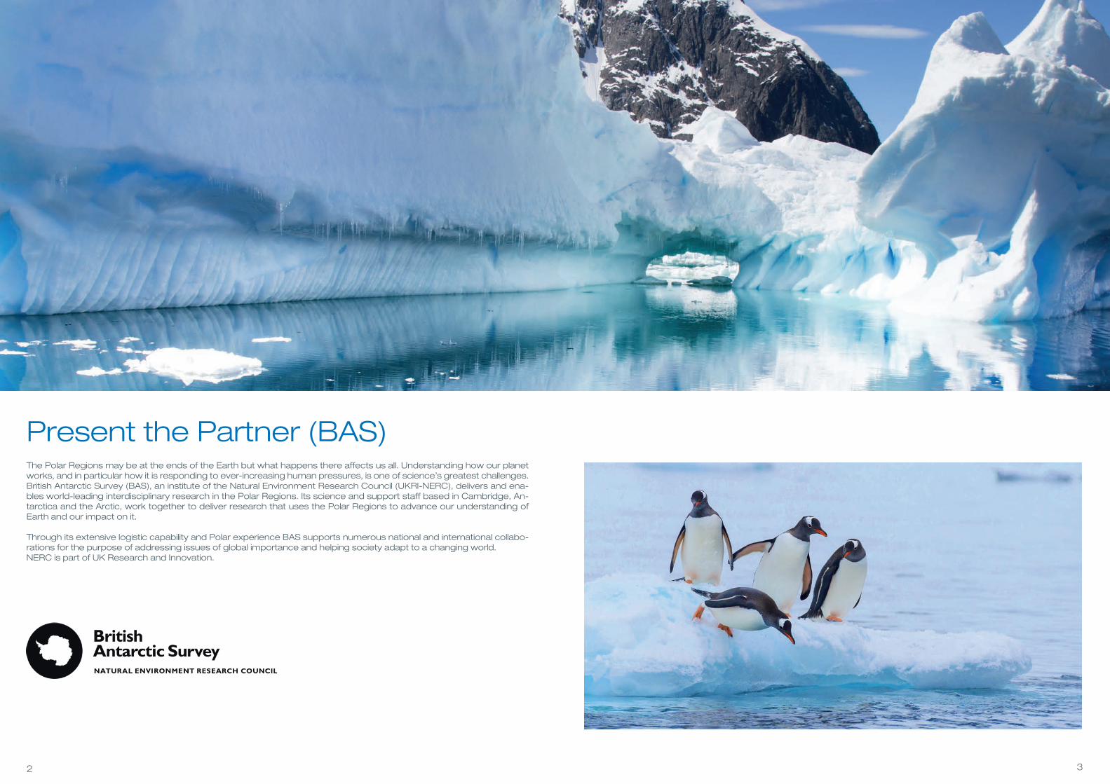
Present the Partner (BAS)The Polar Regions may be at the ends of the Earth but what happens there affects us all. Understanding how our planet works, and in particular how it is responding to ever-increasing human pressures, is one of science’s greatest challenges.British Antarctic Survey (BAS), an institute of the Natural Environment Research Council (UKRI-NERC), delivers and ena-bles world-leading interdisciplinary research in the Polar Regions. Its science and support staff based in Cambridge, An-tarctica and the Arctic, work together to deliver research that uses the Polar Regions to advance our understanding of Earth and our impact on it.
Through its extensive logistic capability and Polar experience BAS supports numerous national and international collabo-rations for the purpose of addressing issues of global importance and helping society adapt to a changing world.NERC is part of UK Research and Innovation.

54
An Introduction to the ProjectOver the past few years BAS has been working with the United Kingdom Antarctic Heritage Trust (UKAHT), a registered charity, to help conserve the historic British bases on the Antarctic Peninsula. These sites were originally established by the Falkland Islands Dependencies Survey (the precursor to BAS) during the 1940’s and 50’s and acted as forward bases from which science and exploration was undertaken on the continent. During their operational lifetimes these bases were occupied year round by a complement of science and support staff (including mountaineers, mechanics and radio ope-rators) on a tour of duty lasting two Antarctic winters or roughly 30 months. Now protected under the Antarctic Treaty as Historic Sites and Monuments (HSMs), UKAHT is undertaking a multi-year conservation programme to save the bases from further degradation and preserve the heritage for future generations.
Running a conservation programme in Antarctica, howe-ver, is not without its challenges. Access is only possible by ship during the Austral summer after the sea ice has cleared, resulting in a compressed field season (Decem-ber to early March). Moreover, Antarctica experiences ex-treme weather year round. High winds along with snow and ice present not only significant operational challenges, but also a direct threat to the preservation of the sites. Fi-nally, the lack of available resources and the challenging environment led to the sites growing ‘organically’. As a result, little accurate ‘as built’ spatial information exists and the original records are often incomplete or missing.
To help overcome these issues UKAHT tasked the Map-ping and Geographic Information Centre (MAGIC) at BAS with capturing a detailed 3D record of each site. The buil-dings or ‘huts’ as Antarctic building are commonly referred to can be complex internally, often with cramped hallways and rooms. A combination of terrestrial laser scanning and photogrammetry was used to build the 3D models. The aim of the project is to allow detailed measurements, pl-anning and preparation and even pre-fabrication of repla-cement materials for conservation work to be undertaken back in the UK. This would reduce the time required on site, and ultimately allow better informed decisions to be made for the long term conservation of the sites.
Transport boat to go from island to islandScanning equipment in waterproof bags
76
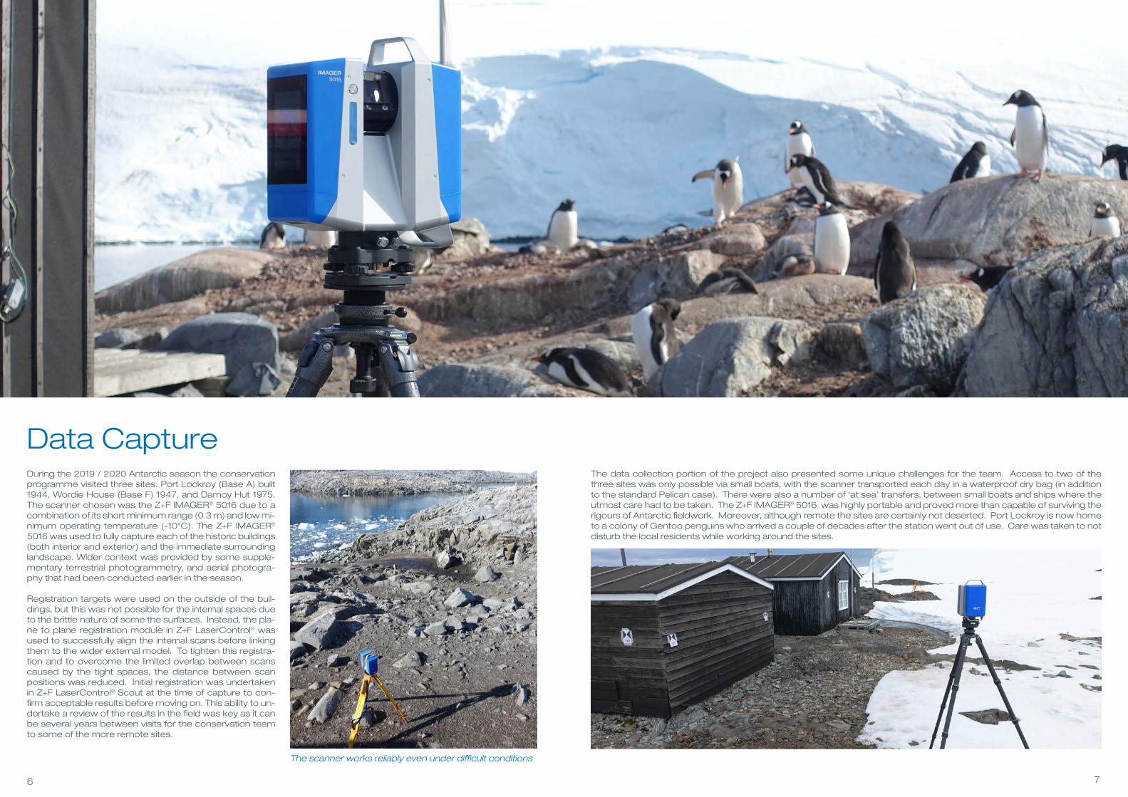
Data CaptureDuring the 2019 / 2020 Antarctic season the conservation programme visited three sites: Port Lockroy (Base A) built 1944, Wordie House (Base F) 1947, and Damoy Hut 1975. The scanner chosen was the Z+F IMAGER® 5016 due to a combination of its short minimum range (0.3 m) and low mi-nimum operating temperature (-10°C). The Z+F IMAGER® 5016 was used to fully capture each of the historic buildings (both interior and exterior) and the immediate surrounding landscape. Wider context was provided by some supple-mentary terrestrial photogrammetry, and aerial photogra-phy that had been conducted earlier in the season.
Registration targets were used on the outside of the buil-dings, but this was not possible for the internal spaces due to the brittle nature of some the surfaces. Instead, the pla-ne to plane registration module in Z+F LaserControl® was used to successfully align the internal scans before linking them to the wider external model. To tighten this registra-tion and to overcome the limited overlap between scans caused by the tight spaces, the distance between scan positions was reduced. Initial registration was undertaken in Z+F LaserControl® Scout at the time of capture to con-firm acceptable results before moving on. This ability to un-dertake a review of the results in the field was key as it can be several years between visits for the conservation team to some of the more remote sites.
The data collection portion of the project also presented some unique challenges for the team. Access to two of the three sites was only possible via small boats, with the scanner transported each day in a waterproof dry bag (in addition to the standard Pelican case). There were also a number of ‘at sea’ transfers, between small boats and ships where the utmost care had to be taken. The Z+F IMAGER® 5016 was highly portable and proved more than capable of surviving the rigours of Antarctic fieldwork. Moreover, although remote the sites are certainly not deserted. Port Lockroy is now home to a colony of Gentoo penguins who arrived a couple of decades after the station went out of use. Care was taken to not disturb the local residents while working around the sites.
The scanner works reliably even under difficult conditions
98
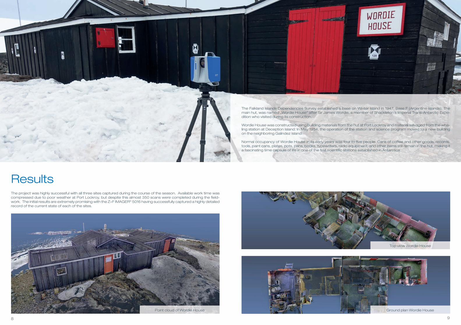
ResultsThe project was highly successful with all three sites captured during the course of the season. Available work time was compressed due to poor weather at Port Lockroy, but despite this almost 350 scans were completed during the fi eld-work. The initial results are extremely promising with the Z+F IMAGER® 5016 having successfully captured a highly detailed record of the current state of each of the sites.
The Falkland Islands Dependencies Survey established a base on Winter Island in 1947, Base F (Argentine Islands). The main hut, was named „Wordie House“ after Sir James Wordie, a member of Shackleton‘s Imperial Trans-Antarctic Expe-dition who visited during its construction.
Wordie House was constructed using building materials from the hut at Port Lockroy and material salvaged from the wha-ling station at Deception Island. In May 1954, the operation of the station and science program moved to a new building on the neighboring Galindez Island.
Normal occupancy of Wordie House in its early years was four to fi ve people. Cans of coffee and other goods, records, tools, paint cans, plates, pots, pans, books, typewriters, radio equipment, and other items still remain in the hut, making it a fascinating time capsule of life in one of the fi rst scientifi c stations established in Antarctica.
Top view Wordie House
Ground plan Wordie HousePoint cloud of Wordie House

1110
Despite the lack of targets the registration of the internal scans using plane to plane was successful. Moreover, the Z+F IMAGER® 5016 overcame both the dark surfaces of the external cladding of the buildings and high-gloss internal surfaces. The high-gloss surfaces in particular have caused problems in the past with photogrammetry. The Z+F IMAGER® 5016was only challenged when at a highly oblique angle to these surfaces (as would be expected) and this was easily over-come due to the density of scans undertaken in the buildings.
The signifi cant increase in effi ciency during data collection that the Z+F IMAGER® 5016 provided, in combination with its performance capturing challenging surfaces and tight spaces was of signifi cant value for the project. The resulting mo-dels will now be handed over to the UKAHT conservation team to allow for more effi cient analysis and management of the sites from a heritage perspective. They will also be used to provide greater public access to the sites, allowing people who may never otherwise have the opportunity to visit Antarctica to explore and experience them virtually.
Boat Shed at Port Lockroy
Damoy Hut on Wiencke Island
Steel chain for fastening boats

Head offi ce – Germany
Zoller + Fröhlich GmbHSimoniusstrasse 2288239 Wangen im AllgäuGermany
Phone: +49 7522 9308-0Fax: +49 7522 9308-252
Subsidiary – UK
ZF UK Laser Limited9 Avocado CourtCommerce WayTrafford ParkManchester M17 1HWGreat Britain
Phone: +44 161 8717 050Fax: +44 161 3125 063
Subsidiary – USA
Z+F USA, Inc.700 Old Pond RoadSuite 606Bridgeville, PA 15017USA
Phone: +1 412 257 8575Fax: +1 412 257 8576
10/2
02
0