Embed Size (px)
Citation preview

Case Study 2: Deans Marsh Gully/Tunnel Erosion
Landscape zone: Upper Barwon
Works dates: Feb. 2005 – May 2005
Site inspected by: Shari Wallis, Neil McInnes (UBLCN), John Turner (CCMA), Simone Wilkinson (CCMA)
What did grant cover? CMIS grant covered approx. 60% of earthworks (contract hire, rubbish removal, clay backfill, top soil and sowing down)
Topographic Map: Map showing catchment area above gully erosion site
• Catchment area above gully site is approx. 5 ha • Ground works area covers approx. 900m sq
Type and extent of threat: (erosion type, area covered, land holders involved, risk to assets) The gully erosion is in a small section of paddock at the base of a planted out gully and runs to the property boundary, which backs onto Penny Royal Valley (PRV) Rd. The gully is approx. 30m above the road with only roadside vegetation and a small strip of paddock between them. The planted section runs down the gully where tunnel erosion has been a problem in the past (10 – 20 yrs ago). The trees have stopped any further tunnelling in that valley This narrow section is the landholders access to one half of the paddock and a site they planned to put in a track in the future.
Site description: (soils, climate, landscape/topography, catchment area, dominant veg/land use)
The site has very dispersive, sodic soils with quite a steep but small catchment (approx. 5 ha) above the gully site. The gully immediately above the collapsed site has had rubbish dumped in an old hole over the years. This may be the entrance site of the tunnelling. Clissolds property is used for cattle grazing as is the majority of the surrounding land. There is a dam located at the top of the gully, above the planted out section.
Severity of threat and impact on assets: (risk to farm assets, production, vegetation, describe impact)
• Assets at risk are paddock access, PRV road and PRV creek • The exit hole of the collapsed tunnel erosion is a small hole (tennis ball size) on the Penny Royal
Valley Rd. The hole is right on the edge of the public road and has dispersed sediments all around it (Photo 3).
• If this exit point enlarges or collapses further it will leave a significant pot hole in the road which the landholders are worried they will be responsible for if any accident occurs.
• Also, sediments removed from the tunnelling will be deposited in the PRV creek which runs directly below the PRV road, approx. 50 – 60m from the tunnel exit point.
• PRV creek is a priority waterway for the CCMA
• Worksplan: • All rubbish was to be dug out and removed from the site prior to any works. • The earthworks required clay fill to be brought in to fill rubbish holes and then be compacted. • The gully area was battered back/filled and covered with top soil. It was also sown with grasses
and planted with trees.
• Top soil was then applied to the whole area and it was sown down with grass seed
• Comments on completed works: • The contractors took months to get on to the job and required lots of phone calls before it
happened.
• Inspection after completion of the site showed the contractors had not removed all the rubbish from the site, some had been partly buried (Photo 4).
• The gully and holes were filled with brought in clay and compacted and the area was sown down to grass seed following completion.

• The fragile part has been fenced and planted out, leaving a wide enough gap for a track to be put through
• A month or two after works were completed a new tunnel hole appeared where the rubbish had not been removed and was partly buried (Photo 5). The landholder had rung Neil McInnes to report the hole.
• Neil and Greg Turner visited the site again and Greg suggested more earth works. Neville was going to monitor the size of the hole.
Before and after photos:
Photo set 1: Looking east up the collapsed tunnel/gully area with the PRV road behind and the planted out gully ahead. The rubbish site and possible entry point of the tunnelling is up amongst the trees.
Photo set 2: Looking west down the gully towards PRV road and after topsoil and seed had been applied.
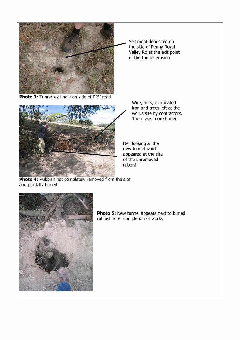
Photo 3: Tunnel exit hole on side of PRV road
Photo 4: Rubbish not completely removed from the site and partially buried.
Sediment deposited on the side of Penny Royal Valley Rd at the exit point of the tunnel erosion
Wire, tires, corrugated iron and trees left at the works site by contractors. There was more buried.
Neil looking at the new tunnel which appeared at the site of the unremoved rubbish
Photo 5: New tunnel appears next to buried rubbish after completion of works
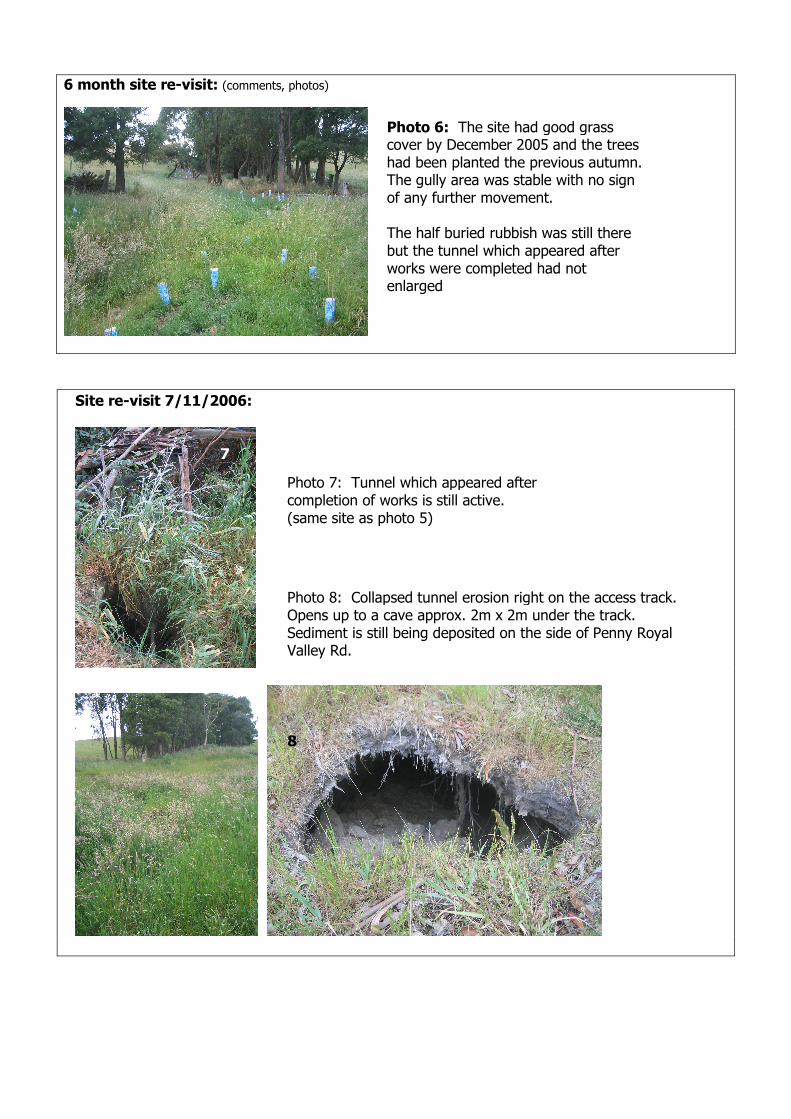
6 month site re-visit: (comments, photos)
Site re-visit 7/11/2006:
Photo 6: The site had good grass cover by December 2005 and the trees had been planted the previous autumn. The gully area was stable with no sign of any further movement. The half buried rubbish was still there but the tunnel which appeared after works were completed had not enlarged
Photo 7: Tunnel which appeared after completion of works is still active. (same site as photo 5)
Photo 8: Collapsed tunnel erosion right on the access track. Opens up to a cave approx. 2m x 2m under the track. Sediment is still being deposited on the side of Penny Royal Valley Rd.
8
7


![City Research Online · probability of surface erosion damage [35], which is attributed to both, hole and string cavitation. Nevertheless, combination of experimental data obtained](https://img.dokumen.tips/doc/110x75/5e92b3bf382f4f4711475c8d/city-research-online-probability-of-surface-erosion-damage-35-which-is-attributed.jpg)