Embed Size (px)
Citation preview

U. S. DEPARTMENT OF THE INTERIOR U. S. GEOLOGICAL SURVEY
CASCADIA:REGIONAL LITHOSPHERIC STUDIES
OF THE PACIFIC NORTHWEST
A FIVE YEAR SCIENCE PLANSUBMITTED TO THE
DEEP CONTINENTAL STUDIES PROGRAM OF THE U. S. GEOLOGICAL SURVEY
from Ray E. Wells 5 , Regional Coordinator
and the THE CASCADIA WORKING GROUP
Open File Report 93-706
1993
This report is preliminary and has not been reviewed for conformity with U.S. Geological Survey editorial standards (or with the North American Stratigraphic Code). Any use of trade, product, or firm names is for descriptive purposes only and does not imply endorsement by the U.S. Government.
1 Menlo Park, CA 94025
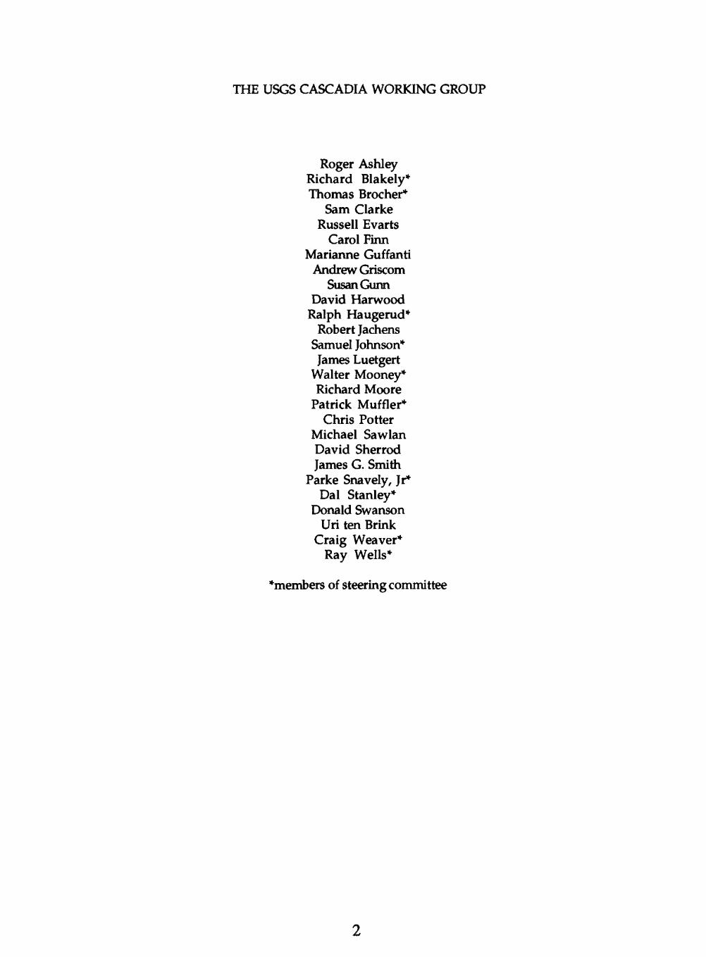
THE USGS CASCADIA WORKING GROUP
Roger Ashley Richard Blakely* Thomas Brocher*
Sam Clarke Russell Evarts
Carol FinnMarianne Guffanti
Andrew GriscomSusan Gunn
David HarwoodRalph Haugerud*
Robert JachensSamuel Johnson*James Luetgert
Walter Mooney*Richard Moore
Patrick Muffler*Chris Potter
Michael SawlanDavid SherrodJames G. Smith
Parke Snavely, Jr*Dal Stanley*
Donald SwansonUri ten Brink
Craig Weaver*Ray Wells*
*members of steering committee

TABLE OF CONTENTS
page
SUMMARY 4
CONCISE RATIONALE 5
FY 93 ACCOMPLISHMENTS 10
RESEARCH PRIORITIES AND FIVE YEAR PLAN . 11 Mendocino Research Corridor 12
FY 94 Tasks 12 Seismic surveys Potential fields surveys Electromagnetic surveys Supporting geoscience
Washington Research Corridor 14 FY 94 Tasks 16
Seismic surveysPotential field surveysElectromagnetic surveysSupporting geoscience
FY 95 Tasks 17 FY 96-97 Tasks 18
Oregon Research Corridor 19 FY 94 Tasks 22
Seismic surveysPotential field surveysElectromagnetic surveysSupporting geoscience
FY 97-98 Tasks 22
Synoptic Investigations 23 Synoptic map series Isotopic studies Teleseismic studies
RELATIONSHIP OF CASCADIA TO OTHER TRANSECTS AND PROGRAMS 24 Existing Transects Other USGS Programs Participation by Academia, Industry, and other Agencies
BIBLIOGRAPHY 26
APPENDICESCascadia projects FY 94 36 Addresses, USGS Cascadia Working Group 37

SUMMARY
WHAT IS CASCADIA?
CASCADIA is a six-year investigation by the USGS Deep Continental Studies Program, in close cooperation with other USGS Programs and the National Science Foundation (NSF), to study fundamental processes of continental growth and evolution along the active Pacific Northwest convergent margin, also known as Cascadia.
WHY STUDY CASCADIA?
Cascadia presents a compact and accessable field laboratory for the study of subduction, continental accretion, and arc volcanism. In Cascadia, we can address nearly all of the major scientific goals identified in A National Program for Research in Continental Dynamics (Phinney and others, 1993):
The origin and evolution of the continents The nature of earthquakes and plate boundary interactions The origin and dynamics of magmas in the continental crust The nature of deformation and mobility in the continental lithosphere The origin and evolution of sedimentary basins The nature of subcontinental mantle and its role in continental evolution
Although Cascadia contains most of the elements typical of convergent margins, it is a unique end member of the subduction zone continuum. The small plates of Cascadia are caught in the dextral shear couple between the encroaching Pacific plate and North America, and Cascadia appears to be tectonically segmenting as the subducting plate and the magmatic arc break up into rotating blocks. Three major convergent margin segments can be recognized:
1) the seismically active subduction zone and transpressive arc of Washington;2) the aseismic subduction zone and extensional arc of central Oregon; and3) the rapidly deforming triple junction region and seismically active arc Basin and Range
transition of northern California.
The compact size of Cascadia allows us to treat the entire plate margin as a system in which fundamental relationships between earthquakes and volcanoes can be explored. CASCADIA can thus provide the "whole-plate" framework essential to address major hazards and earth- resource issues, including active volcanism and the potential for great subduction zone earthquakes adjacent to the fast-growing Northwest urban corridor.
WHAT IS THE PLAN?
CASCADIA investigations are focused in three research corridors, each one centered on a convergent margin segment. Major seismic, electromagnetic, and potential field experiments will be staged in each corridor over a six year span. The results will be integrated with supporting geological and petrological investigations to compare and contrast lithospheric processes in the three different tectonic regimes. When combined with the results of the Canadian LITHOPROBE program and recent NSF-funded studies of the margin, the three corridors will provide an unparalleled, three dimensional view of convergent margin structure and the processes responsible for continental growth and evolution. Our results will be summarized in synoptic map series that covers the entire plate boundary. An integrated crustal model of the Cascadia plate system will provide a solid foundation for resource and hazards based programs in the region.

CONCISE RATIONALE
CASCADIA is a six-year investigation by the USGS Deep Continental Studies Program (DCS), in close cooperation with other USGS Programs and NSF, to study fundamental processes of continental growth and evolution along the convergent margin of the Pacific Northwest. This region, commonly known as Cascadia, is dominated by the Cascade Range, the active volcanic arc forming the backbone of Washington, Oregon, and northern California (fig. 1).
Cascadia presents a compact, accessible field laboratory for the study of subduction, continental accretion, and arc volcanism. In Cascadia we can address six of the eight major scientific goals identified in A National Program for Research in Continental Dynamics (Phinney and others, 1993):
The origin and evolution of the continents The nature of earthquakes and plate boundary interactions The origin and dynamics of magmas in the continental crust The nature of deformation and mobility in the continental lithosphere The origin and evolution of sedimentary basins The nature of subcontinental mantle and its role in continental evolution
Most of these goals can be addressed in the context of Cascadia's classical convergent margin structure, which includes a subducting slab, accretionary complex, and an active volcanic arc and backarc. On the other hand, Cascadia also presents a unique scientific opportunity. As one of the last remnants of a convergent margin that once extended the length of the Cordillera, Cascadia is now undergoing a major tectonic reorganization. Cascadia is caught in the dextral shear couple between the encroaching Pacific plate and North America, and in response, appears to be tectonically segmenting as the remnant subducting plate and the magmatic arc both break up into rotating blocks. The processes of plate breakup, rotation and plate boundary jumps by which subduction ceases and the transform plate boundary grows have clearly played a major role in the late Cenozoic evolution of the continental margin south of the Mendocino triple junction.
Because Cascadia is undergoing a tectonic transition, it presents several important questions relevant to its unique situation: 1) Is Cascadia still capable of great subduction zone earthquakes? If so, where are they likely to occur? 2) Why are volcanoes and earthquakes distributed in such a non-random fashion along the margin? 3) How does the arc and forearc accommodate the tectonic transition? 4) Why is the present margin so discordant with the arcuate Mesozoic orogen that forms the Columbia embayment? Is it the result of continental accretion, rifting and dextral shear of the old continental margin, or some combination of both?
A very important question for those living in the Northwest urban corridor is whether great thrust earthquakes occur on the Cascadia subduction zone. Paleoseismologists who have examined evidence of rapid, episodic subsidence of coastal estuaries argue that great subduction zone earthquakes have occurred every 500 years or so during late Holocene time (eg. Atwater, 1987). Recent geodetic evidence indicates that interseismic strain is accumulating in the Washington forearc and is consistent with the occurence of subduction zone earthquakes (Savage and Lisowski, 1991). Paradoxically, there is no historic or instrumentally recorded evidence for even small earthquakes on the megathrust. As a result, we do not know exactly where the plate interface is located or the extent of the locked zone. A solution to this problem will require a large scale, integrated geophysical experiment across the convergent margin.
Also anomalous is the nature of upper plate seismicity, which shows no apparent relationship to plate convergence; instead it is consistent with N-S compression in the fore arc and is commonly very deep, generally between 10 and 30 km (Ludwin and others, 1991). A major

117°
Figu
re 1
. T
ecto
nic
sett
ing
of th
e C
asca
dia
conv
erge
nt m
argi
n. T
rian
gles
are
maj
or C
asca
de v
olca
noes
; th
rust
fau
lts h
ave
teet
h on
upp
er p
late
, no
rmal
fau
lts
have
bal
l on
dow
nthr
own
bloc
k.

50C
48C
46C
44C
42°
40C
126°T7T~
<s>124
120°
Explorer Plate
^PP<,>^ '«:ti%V ^^wfc%"^""
C ^^s^-^Sk v; '4\.xi>
W^fs & «"1; f^ri 0^iB^fe^
fes&SS?
. ' /> ' // ^x
Juan de Fuca PlateA
AA
Pacific Plate
A
Gorda Plate
'.;i-v^&J
'
0 200km
Northern compressional arc Seismically active Low extrusion rate Lower heat flow Folded basement Small rotation of
forearc
r
Central extensional arc Relatively aseismic High extrusion rate High heat flow Axial graben Large rotation of
forearc
Southern transtensional arc Seismically active Moderate
extrusion rate
4Ukm
Accretionary complex
Crustal Seismicity
Quaternary volcanic rocks
Depth to Benioff zone
Figure 2. Major tectonic segments of the Cascadia convergent margin.

Wen
docl
noC
orrid
Pla
teau
lav
as
Cen
ozoi
c fo
rear
c te
rran
es
p
luto
ns
iM
esoz
oic
plut
ons
and
pre-
Ter
tiar
y ac
cret
ed te
rran
es
Cra
ton
Figu
re 3
. R
egio
nal l
ithos
pher
ic s
tudy
cor
rido
rs in
Cas
cadi
a
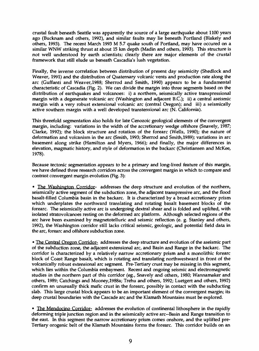
crustal fault beneath Seattle was apparently the source of a large earthquake about 1100 years ago (Bucknam and others, 1992), and similar faults may lie beneath Portland (Blakely and others, 1993). The recent March 1993 M 5.7 quake south of Portland, may have occured on a similar WNW striking thrust at about 15 km depth (Madin and others, 1993). This structure is not well understood by earth scientists; clearly there are major elements of the crustal framework that still elude us beneath Cascadia's lush vegetation.
Finally, the inverse correlation between distribution of present day seismicity (Shedlock and Weaver, 1991) and the distribution of Quaternary volcanic vents and production rate along the arc (Guffanti and Weaver,1988; Sherrod and Smith, 1990) appears to be a fundamental characteristic of Cascadia (Fig. 2). We can divide the margin into three segments based on the distribution of earthquakes and volcanoes: i) a northern, seismically active transpressional margin with a degenerate volcanic arc (Washington and adjacent B.C.); ii) a central aseismic margin with a very robust extensional volcanic arc (central Oregon); and iii) a seismically active southern margin with a well developed transtensional arc (N. California).
This threefold segmentation also holds for late Cenozoic geological elements of the convergent margin, including: variations in the width of the accretionary wedge offshore (Snavely, 1987; Clarke, 1992); the block structure and rotation of the forearc (Wells, 1990); the nature of deformation and volcanism in the arc (Smith, 1993; Sherrod and Smith, 1989); variations in arc basement along strike (Hamilton and Myers, 1966); and finally, the major differences in elevation, magmatic history, and style of deformation in the backarc (Christiansen and McKee, 1978).
Because tectonic segmentation appears to be a primary and long-lived feature of this margin, we have defined three research corridors across the convergent margin in which to compare and contrast convergent margin evolution (Fig. 3):
The Washington Corridor- addresses the deep structure and evolution of the northern, seismically active segment of the subduction zone, the adjacent transpressive arc, and the flood basalt-filled Columbia basin in the backarc. It is characterized by a broad accretionary prism which underplates the northward translating and rotating basalt basement blocks of the forearc. The seismically active arc is undergoing dextral shear and is folded and uplifted, with isolated stratovolcanoes resting on the deformed arc platform. Although selected regions of the arc have been examined by magnetotelluric and seismic reflection (e. g. Stanley and others, 1992), the Washington corridor still lacks critical seismic, geologic, and potential field data in the arc, forearc and offshore subduction zone.
The Central Oregon Corridor- addresses the deep structure and evolution of the aseismic part of the subduction zone, the adjacent extensional arc, and Basin and Range in the backarc. The corridor is characterized by a relatively narrow accretionary prism and a monolithic forearc block of Coast Range basalt, which is rotating and translating northwestward in front of the volcanically robust extensional arc segment. Pre-Tertiary crust may be missing in this segment, which lies within the Columbia embayment. Recent and ongoing seismic and electromagnetic studies in the northern part of this corridor (eg., Snavely and others, 1980; Wannamaker and others, 1989; Catchings and Mooney,1988a; Trehu and others, 1992; Luetgert and others, 1992) confirm an unusually thick mafic crust in the forearc, possibly in contact with the subducting slab. This large crustal block appears to be an important element of the convergent margin; its deep crustal boundaries with the Cascade arc and the Klamath Mountains must be explored.
The Mendocino Corridor- addresses the evolution of continental lithosphere in the rapidly deforming triple junction region and in the seismically active arc Basin and Range transition to the east. In this segment the narrow accretionary prism comes onshore, and the uplifted pre- Tertiary orogenic belt of the Klamath Mountains forms the forearc. This corridor builds on an

active offshore-onshore research program in the triple junction region which includes: young deformation studies (Clarke, 1992; Clarke and Carver, 1992; McLaughlin and others, in press); deep seismic refraction and magnetotelluric profiles across the arc-Basin and Range transition (Fuis and others, 1987; Stanley and others, 1990); and a nearly completed geologic mapping transect from the triple junction to the Basin and Range (D. S. Harwood and others, in prep.). The USGS and the NSF-funded Mendocino Working Group are cooperating on an experiment to study the deep structure and evolution of the Mendocino triple junction in 1993-94.
Our multiple corridors will allow us to approach Cascadia as a tectonic system in which we can investigate fundamental relationships between seismicity, volcanism, and crustal structure. Our corridors complement the LITHOPROBE transect in the adjacent Canadian Cordillera to the north (Clowes and others, 1987) and will extend our knowledge of the active margin across the transition to the San Andreas transform in the south. This broad synoptic view will force us to coordinate between disciplines and to produce well-constrained solutions for the structure and geodynamics of Cascadia.
FY 1993 ACCOMPLISHMENTS
Efforts in FY 93 are focused on the Mendocino Corridor, in cooperation with the Mendocino Working Group, funded by NSF (principal coinvestigators A. Trehu-Oregon State University; S. Klemperer/B. Beaudoin-Stanford; A. Levander-Rice; A. Meltzer-Lehigh). The USGS (Luetgert/Mooney, BSeis) and NSF group cooperated on a series of three refraction-wide angle reflection profiles to study continental crust and upper mantle structure before and after passage of the triple junction. Preliminary results include strong reflections from the subducted Gorda plate north of the triple junction and strong lower crust/ upper mantle reflections north of the Clear Lake volcanic field south of the triple junction (Beaudoin and others, 1993). We are presently analyzing offshore industry seismic reflection data in preparation for FY 94 offshore MCS experiments, also in cooperation with the Mendocino Working Group (Clarke, BPMG).
Other experiments underway include an aeromagnetic survey of the triple junction 0achens and Griscom, BGP) and a magnetotelluric survey (Stanley, BGP) across the northernmost part of the transform boundary just south of the triple junction. Digital compilation of the western part of the NORCAL geologic transect in the triple junction region also has been completed (Harwood/McLaughlin, BWRG). Field and petrologic investigations in the eastern part of the geologic transect (Guffanti/Smith, BVGP; Sawlan, BWMR) are focused on the southern end of the Cascade arc and address the kinematic and petrologic transition at the arc-basin and range tectonic boundary, which has been migrating westward through Quaternary time.
Geological and petrologic investigations also have begun in the Washington Corridor in preparation for major geophysical experiments in FY 1995-96. Detailed mapping is underway in a transect across the Eocene, Oligocene and Miocene Cascade arc in Southern Washington (Swanson/Moore, BVGP; Ashley/Evarts, BWMR), and digital compilation of geology has begun by Washington Division of Geology and Earth Resources . Special emphasis has been given to important crustal boundaries delineated by seismicity, potential fields, and earlier magnetotelluric studies. Analysis continues of seismic refraction data collected in the foothills of the Cascade Range in FY 91. In coordination with the Earthquake Hazards Reduction and Energy Resources Programs (NEHRP and ERSP), we have purchased several hundred km of industry seismic reflection data in western Washington, including Puget Sound. These data are providing critical constraints on crustal structure in the forearc and the nature of post Miocene crustal strain (Johnson and others, in press). They also provide a foundation for the 1995 refraction experiment (Potter, BSP).
10

In the Oregon Corridor, we have begun cooperative studies of major, trace element and isotopic variations in a transect across a well-mapped segment of the Cascade arc east of Roseburg (Sherrod, BVGP; Gunn, BIG; Leeman, Rice U.). This systematic work will define petrologic evolution of the extensional arc segment and will provide a baseline for comparison to the largely transpressive arc of Washington. In the Portland area, we cooperated with National Geologic Mapping Program (NGM) and NEHRP in funding a high resolution aeromagnetic survey of the Portland Metropolitan area (Blakely, BGP; Wells, BWRG; Beeson, Portland State U.; Madin, DOGAMI). This survey was highly successful and delineated a number of potentially active faults beneath downtown Portland. The hazard implications were spectacularly confirmed just three weeks after the press conference by one of Oregon's largest historic earthquakes, a M=5.7 temblor just 30 miles south of Portland. A unique industry reflection profile up the Columbia River provides an opportunity to examine forearc deformation and the structure of the Cascade arc-forearc boundary in this transitional region between the Washington and central Oregon segments (Snavely, BPMG; Niem, Oregon State University). This work will provide an essential interpretation of upper crustal structure and geology in preparation for a unique deep crustal experiment up the Columbia River into the arc in FY 1997. Analysis is continuing of refraction data collected on the east flank of the Coast Range in FY 91 (Luetgert/Mooney, BSeis).
A major effort was made during FY 93 to coordinate the work of DCS, NEHRP and Pacific Marine Geology (PMG), all of which are interested in the deep structure, evolution, and seismic potential of the Cascadia subduction zone. In a series of mini-workshops and coordination meetings, we defined the major deep crustal issues, critical equipment needs, a schedule of possible marine geophysical experiments, and possible sources of funding. We also discussed the value of a new USGS marine geophysical ship as a resource to be shared with the academic community. We expect the ship to be operational for deep seismic in FY 95 or 96 and have scheduled experiments accordingly. In the future, we hope to expand our cooperation with several NSF programs, in particular Continental Dynamics, Structure and Tectonics, and Geochemistry. CASCADIA can provide an important link between NSF and other mission- oriented hazards and resource programs of the USGS in the Pacific Northwest.
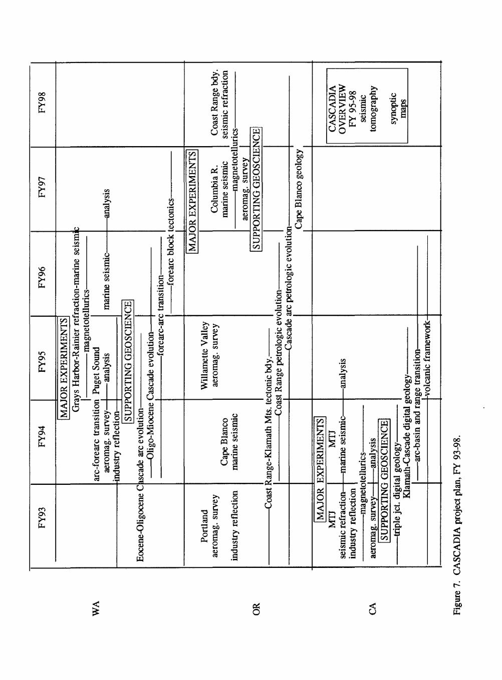
RESEARCH PRIORITIES AND FIVE YEAR PLAN
We have initiated studies in three research corridors that cross the Cascadia convergent margin in northern California (Mendocino), Washington, and Oregon (Figs. 4,5, and 6). North- south tie lines cross important tectonic boundaries between segments and connect the corridors to the Lithoprobe transect in northernmost Cascadia. Our plan is to stage the major geophysical experiments in sequential two-year windows, one for each corridor over the six-year span of the project. Supporting geoscience investigations have already begun in advance of the major geophysical experiments, which are scheduled in the Mendocino Corridor for FY 93-94, in the Washington Corridor in FY 95-96, and in Oregon in FY97-98 (see Fig. 7 for summary schedule). Major tasks in each corridor, along with a brief description, are listed by fiscal year in the following section, and a list of individual projects for FY 94 is in the appendix. Supporting geoscience investigations will continue in each corridor following the major deployments in order to support multidisciplinary analysis of results. In addition to the scientific reports and maps generated for each corridor, we plan a series of synoptic geophysical and tectonic maps of the Cascadia plate system to provide a broad perspective on plate boundary processes.
11

Mendocino Research Corridor
Experiments in the Mendocino Corridor address the evolution of continental lithosphere in the rapidly deforming triple junction region, the Klamath Mountains, and in the seismically active arc-Basin and Range transition to the east. The Mendocino triple junction lies at the southern edge of Cascadia, and it marks the transition from subduction to transform tectonics, from doubled lithosphere to slab-window, from young, buoyant Gorda plate to old, dense Pacific plate, and from a zone of convergence along the Mendocino fault to one of free movement as the Gorda plate passes east of the corner of the Pacific plate. Because it is a transform-transform- trench triple junction, it is inherently unstable, and its history has been punctuated by "jumps" which have resulted in reorganizations of the plate boundaries that have profoundly affected all three plates (Griscom and Jachens, 1989).
Our primary goal in the Mendocino corridor is to investigate the evolution of the continental plate boundary as it changes from convergent to transform margin during passage of the triple junction; in particular we want to examine:
the effect of the encroaching triple junction on the deformation history and seismic potential of the S. Cascadia subduction zone;
the crustal structure and thermal evolution of thinned continental lithosphere along the new transform margin in the wake of the triple junction; and
the petrologic evolution of the southern Cascade arc and the implications for changes in crustal structure during termination of subduction and encroachment of the Basin and Range.
In 1993-94, CASCADIA will cooperate with the Mendocino academic consortium funded by NSF to study the deep structure and evolution of the Mendocino triple junction. An opportunity exists in 1994 to use the R/V Ewing to extend the marine refraction and wide-angle reflection study to the Cape Blanco fracture zone region, which approximately marks the transition to the presently aseismic subduction zone of the central Oregon corridor.
FY94
Task 94.1-Marine Seismic Reflection Survey, triple junction and southern Cascadia subduction zone: (Clarke; DCS/NEHRP/PMG) (A cooperative effort with the NSF Mendocino consortium)
Offshore multichannel seismic reflection surveys can provide detailed control on the structural evolution of the Mendocino triple junction (MTJ) and its effect on the accretionary wedge and Cascadia subduction zone to the north. This element would augment proposed NSF data collection in the MTJ region and address important subduction zone issues. The additional USGS MCS lines would give a 3-dimensional view of plate geometry at depth and of MTJ- related deformation. They would also address important questions concerning the landward extent of the structural boundary between decoupled and coupled parts of the North American accretionary prism, and the offshore location of the pre-Neogene suture between the Franciscan Central and Coastal belts. These questions are not addressed in the proposed NSF coverage. In addition, because the Eocene to Holocene Cascadia accretionary wedge comes onshore just north of the MTJ, the imbricated and folded structures mapped offshore with high resolution seismic methods can also be mapped onshore (Clarke, 1992; Clarke and Carver, 1992). This geometry allows convergent margin structures and basins to be dated and correlated with triple junction migration.
Task 94.2 Analysis of FY 93 seismic refraction and wide angle reflection data: (Luetgert/Mooney; DCS/NEHRP) (A cooperative effort with the NSF Mendocino consortium)
High resolution seismic refraction /wide-angle reflection data collected in 1993 will help define the deep structure of the Mendocino triple junction. Knowledge of the crustal and upper
12

142
26° 1
fv--' '""*
^^.......Ai.....
.^Deforma
tion
STA
GE
I M
EN
DO
CIN
O R
ESE
AR
CH
CO
RR
IDO
R12
4"
122°
41 40°
Gre
at
Valley
Sie
rra
N
evada
Men
doci
rK)
F.Z,
\ D
SDP
Prop
osed
FY94
NSF
R
efle
ctio
n/
Ref
ract
ion
FY94
USG
S/N
SF
Ref
lect
ion/
R
efra
ctio
n
Com
plet
edI
FY93
NSF
/USG
S U
SGS/
CD
MG
/NSF
U
SGS
Ref
ract
ion,
MT
Supp
ortin
g ge
osci
ence
, R
efra
ctio
n, M
T80
% c
ompl
ete
(198
6)
Figure 4.
Exis
ting
and
proposed geophysical
surveys, Mendocino
Research Corridor.
13

mantle velocity structure will allow us to quantify the effects of possible magmatic underplating south of the triple junction, deformation of the Gorda plate and its location at depth, and large-scale tectonic underplating north of the triple junction.
Task 94.3~Magnetotelluric surveys and analysis of the triple junction region (Stanley; DCS/VGP)
Four MT profiles will bracket the MTJ region to examine regional conductivity structure both in front of and behind the northward moving triple junction. The southernmost will be subparallel to seismic refraction line LI of the NSF/USGS experiment; it will cross a major low- velocity anomaly in the crust mapped by Benz and others (1992) and extend into the Lassen Peak area. The northernmost will cross the Klamath Mountains and connect with earlier seismic and MT profiles. The profiles are designed to test: 1) whether low velocity zones mapped by teleseismic methods south of the MTJ are upwelling asthenosphere ("slab window") or possibly underplated Franciscan rocks similar to those underthrust beneath the Klamath Mountains to the north; and 2) whether conductivity characteristics of the southern end of the active Cascades arc near Lassen Peak indicate a difference in mid-crustal level fluid content because of the proximity to the margin of the Gorda plate, and thus determine the southern extent of the Cascades arc.
Task 94.4 Potential field surveys and analysis (Jachens and Griscom; DCS/OMR)Critical elements of the three interacting plates at the Mendocino triple juntion,
particularly the south edge of the Gorda plate, are well defined by their gravity and magnetic anomalies. New aeromagnetic data, spanning both the onshore and offshore regions of Cape Mendocino, could help define the nature of this important boundary and provide continuity among the results of other investigations such as the Mendocino seismic experiment, onshore geologic mapping, seismicity, and neotectonic studies. We will also examine Mendocino triple junction instability over time and its relationship to regional patterns of seismicity and total deformation.
Task 94.5 Supporting Geoscience (Harwood/Smith/Sawlan/Guffanti and others; NGM/VGP/DCS)
A coordinated series of geologic mapping projects, largely funded by other programs have nearly completed a major transect across the continental margin at the latitude of Cape Mendocino. The nine 1:100,000 scale geologic maps of the NORCAL transect span the region from the Mendocino triple junction to the Cascade arc and Basin and Range, including the Franciscan complex, Klamath Mountains overthrust, and the northern Great Valley and Sierra Nevada. In the Sierran foothills, this transect provides a view into the roots of an earlier accretionary complex intruded by granites, potentially a very useful analogue to the late Cenozoic magmatism intruding the Franciscan in the wake of the Mendocino triple junction. Additional detailed geologic and petrologic investigations are underway in the Shasta, Medicine Lake and Lassen volcanic complexes and surrounding areas to examine the evolution of the arc, the spatial and temporal distribution of vents in the southern Cascades, and the interactions with the encroaching Basin and Range province. We expect these projects to continue over the next couple of fiscal years.
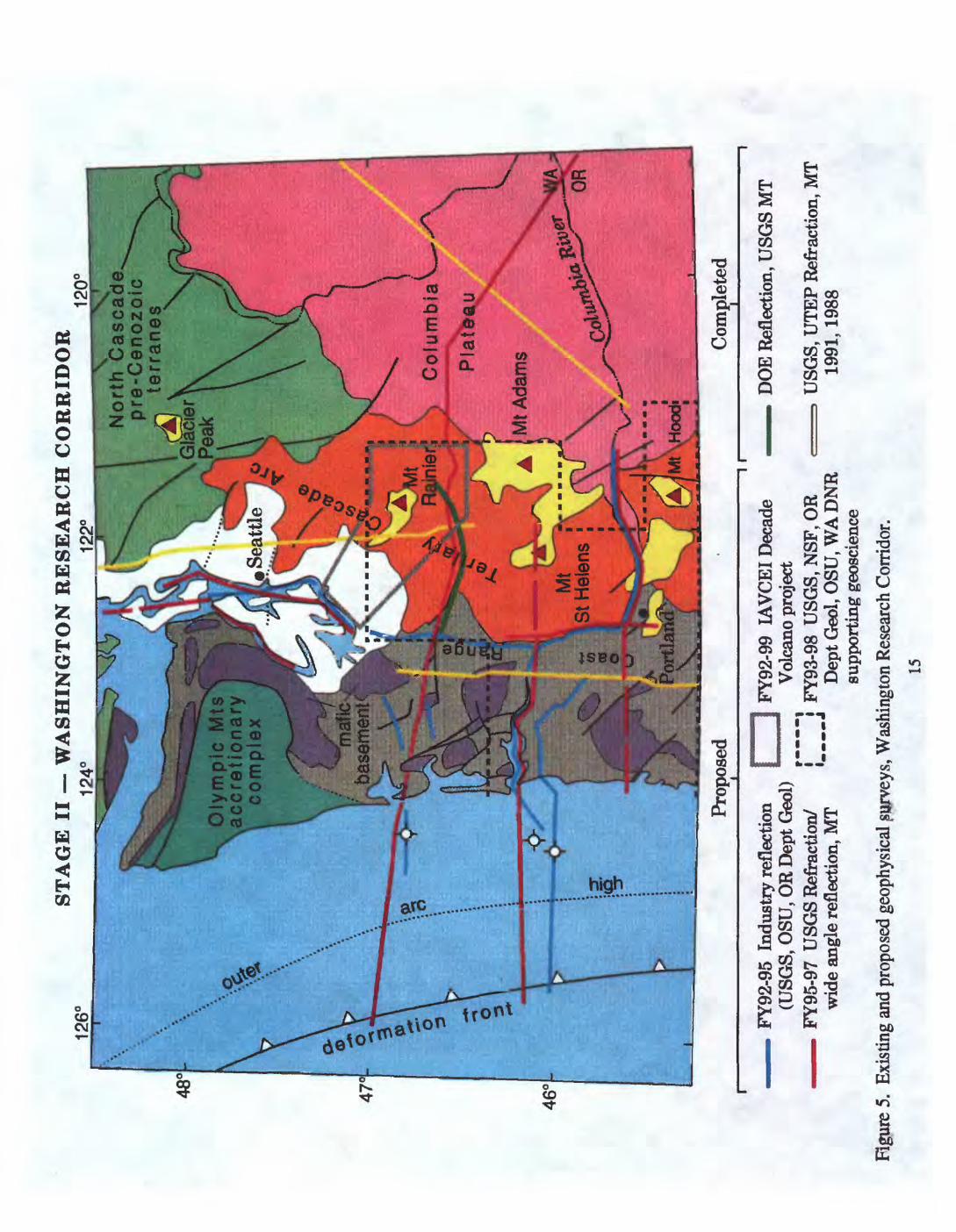
Washington Research Corridor
The Washington Corridor examines the deep structure and evolution of the northern, seismically active segment of the subduction zone, its seismically active dextral transpressive arc, and the subsided Columbia basin in the back arc. The offshore is characterized by a broad accretionary prism which potentially underplates northward translating and rotating basalt
14
126
STA
GE
II W
AS
HIN
GT
ON
RE
SE
AR
CH
CO
RR
IDO
R12
0°
Nort
h C
asc
ade.
pre
-Ce
no
zoic
te
rra
ne
s
Oly
mpic
M
ts
acc
retio
na
ry
com
ple
xS
eatt
le
I4o
V
maf
ic
base
men
t
Colu
mbia
V .
-
Mt A
dam
s
%
ISt
Hel
ens
«
o
Prop
osed
Com
plet
ed
F
Y92
-95
Indu
stry
ref
lect
ion
| |
FY92
-99
IAV
CE
I D
ecad
e (U
SGS,
OSU
, OR
Dep
t G
eol)
__
V
olca
no p
roje
ct F
Y95
-97
USG
S R
efra
ctio
n/
[ j
FY93
-98
US
GS
,NS
F,O
Rw
ide
angl
e re
flec
tion,
MT
" D
ept G
eol,
OSU
, WA
DN
Rsu
ppor
ting
geos
cien
ce
Figu
re 5
. Ex
istin
g an
d pr
opos
ed g
eoph
ysic
al p
urve
ys, W
ashi
ngto
n R
esea
rch
Cor
ridor
.
15
DO
E R
efle
ctio
n, U
SGS
MT
USG
S, U
TE
P R
efra
ctio
n, M
T 19
91,1
988

basement blocks of the forearc. The seismically active arc is undergoing dextral shear and is folded and uplifted, with isolated stratovolcanoes resting on the deformed arc platform.
Our major goal in this corridor is to examine the structure and evolution of the seismically active transpressive convergent margin segment of Cascadia, in particular:
Precisely locate the subducting plate interface and attempt to image the possible locked zone by seismic methods.
Determine the relative importance of tectonic underplating of accretionary wedge versus magmatic underplating in growth of the continental margin.
Define the structures and mechanism responsible for coastwise transport and rotation of forearc crustal blocks, and the nature of the forearc-arc tectonic boundary.
Determine the magmatic and structural evolution of the compressive arc and be prepared to contrast it with evolution of the extensional arc to the south in Oregon.
Other USGS Programs with current interests in this region include: National Earthquake Hazards Reduction, National Geologic Mapping, Evolution of Sedimentary Basins, Marine Geology, Volcano Hazards/Geothermal Research, and Mineral Resources Programs. In FY 93, we began a cooperative effort with NEHRP and ERSP to examine industry seismic reflection data in the Puget Sound area and in southwest Washington. A second cooperative effort was initiated with NGM, BWMR, and BVGP to provide a geological transect across the southern Washington Cascade arc.
FY94
Task 94.6 Industry Seismic Reflection analysis of the forearc (Potter/Johnson; ERSP/DCS/NEHRP)
A network of industry seismic reflection data is available for Puget Sound, southwest Washington, and northwest Oregon. We are analyzing these data to determine upper crustal structural controls on forearc basin formation, evolution, and seismicity. Critical ties between surface geology and deep geophysical information are contained in industry seismic reflection lines collected in Puget Sound, the Puget lowland, and the southwest Washington - northwest Oregon Coast Range. These data demonstrate that the dominant late Eocene to late Miocene structures in and around the Grays Harbor basin, southwest Washington, record complex contractional deformation (thrust faulting, tectonic wedging, and folding) with a north-south to northeast-southwest shortening direction. Recurrent deformation near major crustal faults beneath Puget Sound also records N-NE-directed shortening. The seismic data will be integrated with well data and surface geology to produce a 3D grid of western Washington structure. This grid will provide essential upper-crustal resolution and structural constraints to define Cenozoic forearc basin geometries, the partitioning of strain between strike slip and contractional structures, and their role in clockwise rotation of Coast Range basement during oblique convergence. The data will also clarify the geometry of the Eocene Coast Range - Cascades boundary beneath the Puget lowland, its tectonic history, and its role in arc evolution.
Task 94.7-Potential field studies of the forearc (Blakely/Finn; DCS/NEHRP)New aeromagnetic data will be acquired in southwestern Washington and northwestern
Oregon in order to help constrain the geologic structure and tectonic boundaries between the arc and the northward moving and rotating forearc. This survey will adjoin the highly succesful Portland basin survey which last year identified large, continuous, potentially active structures beneath the city (Blakely and others, 1993). Existing magnetic coverage is inadequate to address the complex structural boundary between the arc and forearc. New aeromagnetic surveys in the region spanning the Columbia River, Willamette Valley, and the western Cascades could help define the structure and lateral extent of Coast Range mafic rocks, their possible control of subduction geometry and arc structure, and their control of crustal
16

seismicity and volcanism. Block boundaries beneath Quaternary cover in the Puget- Willamette lowland are particularly amenable to potential field studies.
Task 94.8--Supporting Geoscience (Ashley/Evarts/Moore/Swanson; NGM/ERSP/VGP/MRS WA DNR).
Geologic mapping underway in the southwest Washington Cascade arc will provide a geological and petrological transect of the transpressive arc segment along the proposed seismic refraction line across the Cascades. The geology of this segment is not well known, although major gravity, aeromagnetic, seismic, and conductivity structures have been recognized in the arc and forearc for at least a decade. In order to constrain the geophysical and petrological models of arc structure and evolution, we must understand the basic stratigraphy and structure of this transpressive arc segment and determine whether major geophysical anomalies (e.g. southwest Washington conductor, St. Helens and Rainier seismic zones, Olympia gravity gradient, etc.) correlate with geological structures accommodating strike slip, crustal shortening and clockwise rotation; or petrologic boundaries in the Paleogene arc that separate Coast Range "oceanic" magmatic sources from arc magma tic sources. Understanding the volcanic evolution of the Tertiary compressive arc, including the style of volcanism, distribution and structural setting of source vents, and chemical variation over time will help constrain the geophysical interpretations. Work is also in progress by the Washington Division of Geology and Earth Resources to digitize several 100K quadrangles along the proposed geophysical transect.
FY95
Task 95.1 Seismic refraction and wide angle reflection survey of the Washington forearc and arc (DCS/NEHRP/PMG)
A combined marine and land seismic survey could image the deep boundary between the accretionary wedge, the offshore extent of the continent and the detailed geometry of the slab. A high resolution land seismic refraction/wide-angle reflection profile could follow these deep structures across the Coast Range, Puget Sound Basin and Cascade arc. This is one of the major objectives of CASCADIA. Tracing the subducting oceanic plate eastward into the trench and beneath the convergent margin is necessary to be certain of the geometry of the subducting plate and the locus of the presumed locked zone. This tracking can be achieved by marine seismic profiling and onshore recording. Complementary high-resolution seismic refraction/wide- angle reflection profiling across the forearc could provide a model of the velocity structure of both the upper crust and the lower crust/upper mantle of the forearc and arc roots. Such a study could be coordinated with IRIS and local research groups to provide an opportunity for university piggy-back or add-on research. The resulting integrated crustal model based on the velocity structure, along with gravity, aeromagnetic, magnetollelluric, seismic reflection, and seismicity data is essential for the accurate evaluation of crustal earthquake mechanisms and could substantially improve our ability to locate earthquakes recorded by the existing seismic net. This experiment could also address the crustal thickness and composition of the presumably accreted Coast Range basalt basement, the extent of the Olympic Mountains subduction complex beneath the Coast Range basalt terrane, and the implications for source areas of great thrust earthquakes in western Washington. This profile will help define the nature of the eastern boundary of the Coast Range basement and its relation to the southwest Washington conductor (SWCC of Stanley and others, 1987; 1992), which appears to coincide with major Cascade volcanoes and seismic zones in southwest Washington. Finally, this experiment addresses in a fundamental way the role of tectonic underplating of oceanic crust and mantle in building the continental crust and the role of magmatic underplating in the arc and backarc. How much crust has been added by these processes, and how has the Moho evolved through time?
17

Task 95.2-Electromagnetic studies in the Washington forearc (Stanley; ERSP/NEHRP/VGP)MT studies will be extended from well studied areas in the Cascades westward across the
Coast Range to provide additional constraints on crustal structure of the forearc. Extensive MT, potential field and seismic reflection mapping of the southern Washington Cascades has defined a regional mid-crustal conductor which appears to localize seismicity and Cascade volcanism (Stanley and others, 1992). Regional north-south MT profiles have been completed along new refraction profiles (Luetgert and others, 1992) but are still being interpreted. Detailed MT surveys along the east-west refraction/wide angle seismic profile from Willapa Bay to White Pass in the Cascades could provide additional constraints on the seismic interpretation of the thickness of the Coast Range basalt crust and underplated sediments. The area of the southern Washington Cascades has been adequately covered, but the region west of the Cascades remains to be surveyed with detailed MT profiles. Ultimately, the east end of the profile could also be extended onto the Columbia Plateau to connect with deep oil wells and proprietary MT data in the area around Yakima to determine sub-basalt structure.
FY 96-97
Task 96.1-Deep seismic experiment in Puget Sound (NEHRP/PMG/DCS)A deep crustal marine seismic reflection survey in Puget Sound recorded by onshore seismic
stations could image the seismogenic middle crust and subducted Juan de Fuca plate. Airgun profiling along a series of lines in Puget Sound recorded onshore by temporary and permanent seismic stations could be used to obtain the first controlled-source tomographic images of deep crustal structure beneath this seismically active and densely populated portion of Cascadia.. The E-W trending Seattle fault, with 9-10 km of vertical displacement on Eocene basement, has been identified as having seven meters of dip slip motion in the past 1000 years (Bucknam and others, 1992) and thus constitutes a major hazard for Seattle. Puget Sound is characterized by some of largest potential field anomalies in the North America and contains the thickest sedimentary basins in Cascadia. Major questions need to be addressed, such as why are the earthquakes so deep in this region and how are the strains pardoned in this transpressional environment? The profiles will examine the deep seismogenic region of the Seattle fault and similar structures as far north as Georgia Strait. This study will be a cooperative effort with the Canadians, IRIS, and university research groups.
Task 97.1-Columbia River seismic refraction/wide angle reflection study (DCS/NEHRP/PMG) A unique onshore-offshore seismic survey running up the Columbia River could image the
deep boundary between the accretionary wedge, the offshore extent of the continent and the detailed geometry of the slab, which may be broken in this region. A high resolution seismic refraction/wide-angle reflection profile could follow these deep structures across the Coast Range, Willamette Basin and Cascade arc. The Columbia River represents a unique opportunity along Cascadia where a modern seismic vessel can transect the deformation front, the subduction trench, the continental slope and shelf, the Coast Ranges, and even the arc itself. The USGS already possesses industry seismic reflection data acquired up the Columbia River which images crustal structure down to 3 seconds. By deploying a large number of closely spaced recorders on the shores of the Columbia River, and steaming up the river with a large airgun array, we should be able to image the middle and lower crust as demonstrated for similar experiments in San Francisco Bay and in Prince William Sound (Brocher et al., 1993; Brocher and Moses, 1990). The experimental design will simultaneously provide low-fold seismic reflection coverage of the middle to lower crust as well as dense wide-angle recordings to provide a detailed seismic velocity model along the transect. Due to the sharp bend in the Columbia River, two parallel profiles can be obtained (Figure 5). The northern side will connect directly offshore to a marine line and be extended east of the bend via unreversed recorders. The southern transect, at the latitude of Portland, will consist of airgun shots recorded on a sparser array in the coast range as well as densely spaced recorders deployed along the Columbia River. Completion of this transect will fill the gap between the Grays
18

Harbor transect where the margin is transpressional and the central Oregon transect described by Trehu and others (1992), where the margin is transtensional.
Task 97.2 Deep seismic experiment across the Olympic accretionary complex (NEHRP/PMG/DCS)
A deep crustal marine seismic reflection survey seaward of the Olympic Peninsula recorded by onshore seismic stations could image the accretionary wedge complex and the subducted Juan de Fuca plate. Land seismic profiling could be used to examine the accretionary wedge complex in the only place where it comes ashore along the Cascadia margin. This onshore-offshore transect would complement the profiles obtained in Puget Sound and would focus on tracking the subducted Juan de Fuca plate to depth and determining the internal structure of the accretionary complex. According to some models, this accretionary complex deforms plastically while blocks of Coast Range basalt basement are fragmented into blocks during northward transport around the accretionary complex. This transect would focus on the locked portion of the subduction complex, which Hyndman and others, (1992) suggest is capable of generating large-magnitude earthquakes along the Cascadia margin.
Central Oregon Research Corridor
The Central Oregon Corridor addresses the deep structure and evolution of the aseismic part of the subduction zone, the adjacent extensional arc, and the Basin and Range in the backarc. It is characterized by a well-developed accretionary prism and a large, thick forearc block of Coast Range basalt, which is rotating and translating northwestward in front of the volcanically robust extensional arc segment. Pre-Tertiary crust may be missing in this segment, which lies within the Columbia embayment. This embayment is a major re-entrant in the Cordilleran erogenic belt, presumably formed by continental rifting or collisional processes. The eastern part of the embayment is covered by Miocene flood basalts of the Columbia River Basalt Group, which erupted from dike swarms in the Blue Mountains.
Our major goal in this corridor is to investigate the structure and evolution of the aseismic, extensional arc segment of the Cascadia convergent margin; in particular:
Precisely locate the plate interface and produce a seismic image of potential asperites; be prepared to compare with similar work off seismically active Washington Compare the relative importance of tectonic vs. magmatic contributions to crustal growth in Oregon vs Washington Determine the magmatic and structural evolution of the extensional volcanic arc and be prepared to contrast it with the compressional arc in Washington and the transtensional arc in California
Important lithospheric-scale seismic and electromagnetic studies have already begun in the extensional corridor (e.g., Wannamaker and others, 1989; Catchings and Mooney,1988a; Trehu and others, 1992; Luetgert and others, 1992); however, basic questions remain regarding the structure of the subduction zone, its interaction with Coast Range basalt crust, and the peculiar aseismic nature of this margin segment. Further questions remain regarding mid-crustal fluids inferred from the conductivity structure and their role in seismogenesis (or lack thereof) and magmatism.
19

45°
126°
STA
GE
III
124°
OR
EG
ON
RE
SEA
RC
H C
OR
RID
OR
122°
Blu
e M
ts
Mz
- P
z te
rra
ne
s
Kla
mat
h M
ts
/ M
z -P
z '
' te
rra
ne
sPr
opos
edC
ompl
eted
FY94
U
SGS
MC
S of
fsho
re
FY97
U
SGS
Ref
ract
ion
onsh
ore
USG
S/O
R D
ept
Geo
l/NSF
S
uppo
rtin
g ge
osci
ence
(i
n pr
ogre
ss)
USG
S R
efra
ctio
n (1
984,
198
8, 1
991)
EM
SLA
B
Res
isti
vity
--
x-
sect
ion
(198
9)
Seis
mic
Ref
lect
ion
USG
S of
fsho
re,
CO
CO
RP
onsh
ore
(198
0,19
85,
1989
)N
SF-E
DG
E M
CS
and/
or R
efra
ctio
n (1
989)
Figu
re 6
. Ex
istin
g an
d pr
opos
ed g
eoph
ysic
al s
urve
ys, O
rego
n R
esea
rch
Cor
ridor
.
WA
FY93
Eoce
ne-O
ligoc
ene
C
FY94
FY95
MA
JOR
EX
PER
IME
NT
S
FY96
Gra
ys H
arbo
r-R
aini
er r
efra
ctio
n-m
arin
e se
ism
ic
- magneto
tell
uri
cs
arc-
fore
arc
tran
sitio
n Pu
get S
ound
aero
mag
. su
rvey
| a
nal
ysi
s in
dust
ry r
efle
ctio
n-m
anne
sei
smic
-
SUPP
OR
TIN
G G
EO
SCIE
NC
Eis
cade
arc
evolu
tion
Oli
go-M
ioce
ne C
asca
de e
volu
tion
-for
earc
-arc
tra
nsiti
on-
FY97
-ana
lysi
s
-for
earc
blo
ck te
cton
ics-
FY98
MA
JOR
EX
PER
IME
NT
SPo
rtla
nd
aero
mag
. su
rvey
indu
stry
ref
lect
ion
Cap
e B
lanc
o m
arin
e se
ism
ic
Will
amet
te V
alle
y ae
rom
ag.
surv
ey
OR
Col
umbi
a R
. m
arin
e se
ism
icC
oast
Ran
ge b
dy.
seis
mic
ref
ract
ion
-mag
neto
tellu
rics
-ae
rom
ag.
surv
eySU
PPO
RT
ING
GE
OSC
IEN
CE
Coa
st R
ange
-Kla
mat
h M
ts. t
ecto
nic
bdy.
-C
oast
Ran
ge p
etro
logi
c ev
olut
ion-
Cas
cade
arc
pet
rolo
gic
evol
utio
n- Cap
e B
lanc
o ge
olog
y
MAJ
OR E
XPER
IMEN
TS]
MT
J
CA
seis
mic
ref
ract
ion
mar
ine
seis
mic
- in
dust
ry r
efle
ctio
n
mag
neto
tellu
rics
-MT
J-a
naly
sis
aero
mag
. sur
vey-
-ana
lysi
sSU
PPO
RT
ING
GE
OSC
IEN
CE
riple
jet.
digi
tal
geol
ogy-
Kla
mat
h-C
asca
de d
igita
l geo
logy
-
CA
SCA
DIA
OV
ER
VIE
WFY
95-
98se
ism
icto
mog
raph
y
syno
ptic
m
aps
-arc
-bas
in a
nd r
ange
tran
sitio
n- v
olca
nic
fram
ewor
k-
Figu
re 7
. C
ASC
AD
IA p
roje
ct p
lan,
FY
93-
98.

FY94
Task 94.9 Marine reflection and wide angle seismic refraction/reflection, Cape Blanco region (Clarke/Brocher; DCS/NEHRP/PMG)
Land recordings of a marine seismic reflection survey in the vicinity of the Blanco fracture zone could help image the deep boundary between the accretionary wedge, the offshore extent of the continent and the detailed geometry of the slab in this transitional region. The Blanco fracture zone intersects Cascadia in the vicinity of the transition between the seismically active arc in northern California and the aseismic arc in central Oregon and represents the focus of many prominent latitudinal changes along Cascadia. The width of the accretionary prism, the age of the subducting oceanic crust, and the nature of the bedrock in the Coast Ranges all change dramatically norm of the Blanco fracture zone. The proposed marine seismic reflection lines are designed to investigate the offshore extensions and connections of the Fulmar fault as well as a major suture zone between the Tertiary mafic rocks (equivalent to the Siletz River Volcanics) north of this region and the Mesozoic accreted terranes in the Klamath Mountains (with its Franciscan assemblage equivalents). The profiles would be located in the very center of the aseismic part of Cascadia and, in the absence of seismicity, are thus a direct means of determining the geometry of the subducted oceanic crust there. These profiles could be compared to an existing profile across the northern Oregon extensional arc and work in progress just north of the triple junction.(Trehu and others, 1992,1993).
Task 94.10-Supporting Geoscience (Sherrod/Wells; NGM/VGP/DCS)Geologic mapping has defined a major tectonic boundary between the oceanic basalt of the
Coast Range and the Klamath Mountains in southern Oregon which projects beneath the Cascade arc. The following topical studies will be undertaken to constrain interpretations of existing reconnaissance MT and proposed geophysical lines across this boundary: 1) Structural mapping along the only U.S. exposure of this major tectonic boundary between Coast Range basalt and pre-Tertiary continent to define the geometry, kinematics, and origin of the suture, either as a subduction zone or rift basin margin ; 2) a petrologic traverse across the extensional Cascade arc at the latitude of Roseburg to asses temporal changes in magma source and to compare to a traverse in progress across the compressional arc in Washington; 3) geologic and petrologic characterization of unusual tholeiitic and alkaline suites in the Oregon Coast Range to determine their tectonic significance (Wells and Snavely USGS; Duncan and Pyle, OSU). These compositions are unusual in a forearc setting and may reflect unusual tectonic circumstances. Petrologic modelling of their source zones could constrain lithospheric structure and tectonic history of the forearc; and 4) structural analysis of the forearc to test models of tectonic rotation and strain partitioning into pure and simple shear domains during oblique subduction.
FY 97-98
Task 973-Electromagnetic and Potential field studies in Oregon (Stanley/Blakely; DCS)MT, aeromagnetic, and gravity studies in southwest Oregon could help define the geometry
of the Columbia embayment, accretionary terrane boundaries, and possible segmentation of the Cascade volcanic arc. Some of the largest-amplitude magnetic anomalies in North America occur along a north-south band within the Western Cascades of Oregon, but near surface rocks in the area do not appear to be the source of the anomalies. They may reflect Eocene accreted Coast Range oceanic crust (Blakely, 1992), ultramafic rocks accreted during Eocene time (Johnson and others, 1990), or granodiorite intrusions of the Western Cascades (Finn, 1991). Understanding the causes of these enigmatic anomalies is critical to our understanding of the structural boundary between the forearc and arc. In southwest Oregon,this anomaly terminates at a major terrane boundary between the Oregon-Washington Coast Range and the Mesozoic terranes of the Klamath Mountains, which project northeastward toward the Blue Mountains beneath the Western Cascades. Gravity anomalies associated with the suture continue
22

northeastward on strike with a distinctive gravity gradient that parallels the Blue Mountains (Riddihough and others, 1986; Blakely and Jachens, 1990). Additional studies may show a connection between these two parts of the pre-Cenozoic orogenic belt and define the geometry of the Columbia embayment beneath the Cascade arc. New surveys could also define the structure of the suture zone between Paleogene oceanic terranes and pre-Tertiary continent, and its extent beneath the Western Cascades.
Synoptic Investigations
FY94
Task 94.11-Cascadia Plate Map Series (Haugerud and others; DCS/NGM/NEHRP)A series of synoptic maps of the Cascadia plate system will provide a holistic overview of
the topography, geology, and geophysics of the entire convergent margin. We are using the Canadian Juan de Fuca plate map series of the late 1970's as our inspiration, but we are creating digital products from digital datasets. Our objective is to create a series of digital maps of Cascadia at a provisional scale of 1:2,000,000, including; topography, tectonic assemblage, gravity, aeromagnetic, crustal thickness, heat flow, isotopic provenance, volcanic vent distributions, and velocity structure, among others. These will be useful in analyses of convergent margin tectonic processes.
Task 94.12-Isotopic systematics of the Cascade arc (Gunn and others; NGM/DCS)The systematic acquisition of Sr, Nd, and common Pb isotopic compositions of volcanic and
plutonic rocks of the Cascade arc will provide constraints on the composition, age and evolution of deep crust and mantle source regions beneath the arc. The lower crust and mantle source regions beneath the arc are likely to vary along strike, because the arc is built across the Columbia embayment, a reentrant in the pre-Tertiary orogenic belt in Cascadia. Primitive basalts along the arc should provide isotopic signatures characteristic of the mantle source regions, whereas granitic plutons may contain a signature of lower-crustal variations. A systematic isotopic mapping of arc source variability in space and time could provide important constraints on deep continental structure when combined with the geophysical and geological data.
FY95
Task 95. 3-Teleseismic imaging of the deep lithosphere (DCS/NEHRP)Teleseismic studies of P- and S-wave velocities and attenuation would provide constraints
on the composition, structure, and current state of the whole lithosphere and underlying asthenosphere of the Cascadia plate system. After FY 95, these studies would have the advantage of a relatively detailed crustal velocity model constrained by a network of controlled-source seismic experiments. Temporary arrays of short-period and broad-band seismographs will augment the regional seismic network and permit the application of a broad suite of seismic techniques, ranging from teleseismic delay times to surface wave inversions for crustal and upper mantle structure. Important objectives include: 1) high-resolution images of the subducting slab beneath the arc and forearc, with particular emphasis on apparent segment boundaries inboard of Cape Blanco and the mouth of the Columbia River; 2) comparative anatomy of the lithosphere and asthenosphere beneath the compressional, extensional, and transtensive Cascade arc segments; and 3) characterization of the mantle source of late Cenozoic volcanic fields of eastern Oregon and the Columbia Plateau.
23

RELATIONSHIP OF CASCADIA TO OTHER TRANSECTS AND PROGRAMS
Existing transects
The CASCADIA experiment is built on an existing, but widely spaced framework of lithospheric studies in the Northwest. The internationally acclaimed LITHOPROBE transect of the Canadian Cordillera has recently been completed just north of the U.S. border and provides a model for succesful interdisciplinary study. Although the extensive young volcanic terrane of Cascadia is in marked contrast to the Canadian Cordillera, Lithoprobe affords an integrated view of the mostly pre-Tertiary erogenic belt which projects southward beneath the volcanic rocks and provides a northern anchor for the experiment. In Oregon, the recently completed EMSLAB experiment has produced the most comprehensive electromagnetic study of a convergent margin, and has determined a lithospheric conductivity structure that demands testing by other geophysical and geological methods. Glimpses of deep crustal structures can also be seen on industry, DOE, and COCORP seismic reflection lines in the forearc, arc and backarc. Widely spaced academic and USGS seismic refraction lines provide provincial velocity structure, but require tie lines across important tectonic boundaries.
Other USGS Programs
A long term investment in the Northwest by several USGS programs (particularly Geothermal Research(GRP), Volcano Hazards(VHP), Earthquake Hazards Reduction(NEHRP), Mineral Resource Surveys (MRS), National Geologic Mapping (NGM), and Pacific Marine Geology (PMG) has provided the geological and geophysical framework for identifying critical gaps in our knowledge and defining critical experiments. CASCADIA is cooperating with those USGS programs having strategic interests in the Pacific Northwest. The project advisory committee includes representatives from Earthquake Hazards Reduction, Energy Resource Surveys(ERSP), Geothermal Research, Volcano Hazards, Geologic Mapping, Mineral Resources, and Pacific Marine Geology. We are addressing issues of common scientific interest and effectively marshalling our resources through a series of workshops co-sponsored by DCS and other USGS programs.
The potential for large subduction-zone earthquakes is a good example of a first order problem that is also of primary interest to the National Earthquake Hazards Reduction Program and the Nuclear Regulatory Commission. Another example of potential collaboration between programs is the proposed joint purchase by DCS, ERSP, and NEHRP of industry seismic data in southwest Washington in order to examine the relationship between crustal seismicity and three-dimensional forearc crustal structure. We expect a combined effort among DCS, NEHRP, and PMG on several large onshore-offshore geophysical experiments.
Participation by Academia, Industry, and other Agencies
The steering committee is coordinating USGS goals with those of the National Science Foundation, Department of Energy, Nuclear Regulatory Commission, State Geological Surveys, universities, and industry to insure an integrated approach to deep continental investigations in the Pacific Northwest.
Our geologic and land refraction expertise in the Mendocino research corridor compliments the Mendocino academic consortium experiment (funded by NSF) to study the structure and deep crustal processes associated with migration of the Mendocino triple junction along the continental margin. Additional academic collaboration is expected on evolution of the accretionary wedge (e.g. Brandon and others, Yale University); geochemical evolution of the
24

arc and forearc (e.g. Leeman, Rice University; Duncan, Oregon State); and teleseismic structure of convergent margin (Nabelek, Oregon State; Humphreys, University of Oregon; Crosson, University of Washington).
The Fossil Fuels Division of the Department of Energy has had a major interest in western Washington basins and especially in the southern Washington Cascades conductor (SWCC) region, where it funded major deep reflection surveys. DOE interest has currently shifted to the Gulf Coast, but our program may serve to interest DOE in renewed support of research or deep drilling.
The Bureau of Indian Affairs (BIA) has a mandated interest in geophysical and geological data for the CASCADIA region. Proposals with the USGS have been formulated to study specific reservations such as the Warms Springs reservation of Oregon and the Yakima reservation in Washington. Reservations in western Washington have been involved in proposals developed by BIA and USGS to evaluate energy and mineral resources in the numerous (25) reservations in the Puget Lowland and nearby environs. BIA is particularly interested in supporting data base development and regional syntheses of geology and resources. A total of 40 reservations occur in CASCADIA and close coordination with BIA and individual reservations will be necessary to provide access and cooperation with them. Energy and mineral assessment issues are handled by the BIA Division of Energy and Mineral Resources in Denver in coordination with the BIA Area Office in Portland.
The IAVCEI Mount Rainier Decade Volcano project to examine the evolution of the volcanic edifice, its tectonic setting, and its hazard implications coincides with DCS, NEHRP, and ERSP goals to study the deep structure of the tightly folded and seismically active arc in the vicinity of Mount Rainier. Decade Volcano mapping of the volcanic edifice and the bedrock foundation will be coordinated by the Branch of Volcano and Geothermal Processes; crustal structure will be addressed by DCS and NEHRP.
In addition to the active collaboration with the Mendocino group (Ann Trehu, Simon Klemperer, Alan Levander, and Anne Meltzer at Oregon State University, Stanford, Rice, Lehigh, respectively), a number of researchers have expressed interest in future collaboration with the USGS CASCADIA effort, including:
Mark Brandon Yale University (Northwest tectonics)Ron Clowes University of British Columbia (Crustal structure of the Canadian Cordillera)Robert Crosson University of Washington (Northwest seismology)Robert Duncan, Doug Pyle, Oregon State University (Ar/Ar, Isotopes, Trace element
geochemistry, Coast Range magmatism)Don Hull Oregon State GeologistEugene Humphreys University of Oregon (Mantle structure and geodynamics)Ray Lasmanis Washington State GeologistWilliam Leeman Rice University. (Trace element and Isotope geochemistry, Cascade Arc)Megan Miller Central Washington State University. (Blue Mts geology)Jim Monger Geological Survey of Canada (Geology of the Canadian Cordillera)Alan Niem Oregon State University (Coast Range basin history)George Priest Oregon Department of Geology and Mineral Industries (Cascade volcanism)Ray Weldon University of Oregon (Kinematics)Harve Waff University of Oregon (Electromagnetics)Tom Wylie Oregon Department of Geology and Mineral Industries (Klamath Mts. geology)
25

BIBLIOGRAPHY
Atwater, B.F., 1987, Evidence for great Holocene earthquakes along the outer coast of Washington State: Science, v. 236, p. 942-944.
Beck, M.E., 1989, Paleomagnetism of continental North America; implications for displacement of crustal blocks within the Western Cordillera, Baja California to British Columbia, in Geophysical Framework of the Continental United States, edited by L.C. Pakiser and W.D. Mooney: Mem. Geol. Soc. Am., v. 172, p. 471-492.
Benz, H., Zandt, G., and Oppenheimer, D. H., 1992, Lithospheric structure of northern California from teleseismic images of the upper mantle: Journal of Geophysical Research, v. 97, p. 4791-4807.
Berg, J.W., Jr., Trembly, L., Emilian, D.A., Hutt, J.R., King, J.M., Long, L.T., McKnight, W.R., Sarmah, S.K., Souders, R., Thiruvathukal, J.V., and Vossler, D.A., 1966, Crustal refraction profile, Oregon Coast Range, Seismol. Soc. Amer. Bull., v. 656, p. 1357-1362.
Blackwell, D.D., Bowen, R.G., Hull, D.A., Riccio, }., and Steele, J.A., 1982, Heat flow, arc volcanism, and subduction in northern Oregon: Journal of Geophysical Research, v. 87, p.8735-8754.
Blackwell, D.D., and Steele, J.L., 1983, A summary of heat flow studies in the Cascade Range: Transactions of the Geothermal Resources Council, v. 7, p. 233-236.
Blackwell, D.D., Steele, J.L., Frohme, M.K., Murphey, C.F., Priest, G.R., and Black, G.L., 1990a, Heat flow in the Oregon Cascade Range and its correlation with regional gravity, Curie Point depths, and Geology: Journal of Geophysical Research, v. 95, p. 19,475-19,493.
Blackwell, D.D., Steele, J.L., Kelley, S., and Korosec, M.A., 1990b, Heat flow in the state of Washington and thermal conditions in the Cascade Range: Journal of Geophysical Research, v. 95, p. 19,495-19,516.
Blake, M.C., and Jayko, A.S., 1986, Tectonic evolution of northwest California and southwest Oregon: Geological Society of France Bulletin, v. 6, p. 921-930.
Blakeley, R.J., 1993, Extent of partial melting beneath the Cascade Range, Oregon: constraints from gravity anomalies and ideal-body theory: Journal of Geophysical Research (in press).
Blakeley, R.J., and Jachens, 1990, Volcanism, isostatic residual gravity, and regional tectonic setting of the Cascade volcanic province: Journal of Geophysical Research, v. 95, p. 19,439- 19,451.
Blakely, R. J., Beeson, M. H., Madin, I. P., Popowski, T., Wells, R. E., and Yelin, T. S., 1993, Tectonic implications of a high resolution aeromagnetic survey of the Portland basin, Oregon and Washington: Geological Society of America Abstracts with Programs, v. 25, p. 10.
Bond, K.R., and Zeitz, I., 1987, Composite magnetic anomaly map of the conterminous United States west of 96° longitude: U.S. Geological Survey Geophysical Investigation Map GP- 977, scale 1:2,500,000.
26

Brandon, M.T., and Calderwood, A.R., 1990, High-pressure metamorphism and uplift of the Olympic subduction complex: Geology, v. 18, no. 12, p. 1252-1255.
Brandon, M.T., Miller, D.S., and Vance, J.A., 1988, Fission-track dates for initiation and uplift of the Cenozoic subduction complex of the Olympic Mountains, northwest Washington: Geological Society of America Abstracts with Programs, v. 20, p. 145.
Brocher, T.M., and Moses, M.J., 1990, Wide-angle seismic recordings obtained during the TACT multichannel reflection profiling in the northern Gulf of Alaska: U.S. Geological Survey, Open-file Report 90-663, 40 pp.
Brocher, T.M., and Moses, M.J., 1993, Onshore-offshore wide-angle seismic recordings of the 1989 Alaskan EDGE profile: Five-day recorder data: U.S. Geological Survey, Open-file Report 93-238, 26 pp.
Brocher, T.M., Moses, M.J., Fisher, M.A., Stephens, C.D., and Geist, E.L., 1991, Images of the plate boundary beneath southern Alaska, in Meissner, R., L. Brown, H. Durbaum, W. Franke, K. Fuchs, and F. Seifert, editors, Continental Lithosphere: Deep Seismic Reflections: Geodynamics Series, Volume 22, p. 241-246, AGU, Washington, D.C.
Brocher, T.M., Moses, M.J., and Trehu, A.M., 1993a, Onshore-offshore wide-angle seismic recordings from central Oregon: the five-day recorder data: U.S. Geological Survey Open- file Report 93-318, 25 pp.
Brocher, T.M., Moses, M.J., and McCarthy, J., 1993b, Onshore-offshore wide-angle seismic recordings of the San Francisco Bay Area Seismic Imaging experiment (BASIX): The five- day recorder data: U.S. Geological Survey Open-file Report 93-xxx, 80 pp.
Bucknam, R. C., Hemphill-Haley, E. and Leopold, E. B., 1992, Abrupt uplift within the past 1700 years at southern Puget Sound, Washington: Science, v. 258, p. 1611-1614.
Catchings, R.D., and Mooney, W.D., 1988a, Crustal structure of the Columbia Plateau; Evidence for continental rifting: Journal of Geophysical Research, v. 93, p. 459-474.
___, 1988b, Crustal structure of east-central Oregon; Relationship between Newberry volcano and regional crustal structure: Journal of Geophysical Research, v. 93, p. 10,081-10,094.
Christiansen, R. L., and McKee, E. H., 1978, Late Cenozoic volcanic and tectonic evolution of the Great Basin and Columbia intermontaine regions: Geological Society of America Memoir 152, p. 283-311.
Clarke, S.H. Jr., 1992, Geology of the Eel River basin and adjacent region: implications for Late Cenozoic tectonics of the southern Cascadia subduction zone and Mendocino triple junction: American Association of Petroleum Geologists Bulletin, v. 76, no. 2, p. 199-224.
Clarke, S.H. Jr., and Carver, G.A., 1992, Late Holocene Tectonics and Paleoseismicity, southern Cascadia subduction zone: Science, v. 255, p. 188-192.
Clowes, R.M., Brandon, M.T., Green, A.G., Yorath, C.J., Brown, A.S., Kanasewich, E.R., and Spencer, C, 1987, LITHOPROBE, southern Vancouver Island; Cenozoic subduction complex imaged by deep seismic reflections: Canadian Journal of Earth Sciences, v. 24, p. 31-51.
Cockerham, R.S., 1984, Evidence for a 180-km-long subducted plate beneath northern California: Bulletin of the Seismological Society of America, v. 74, p. 569-576.
27

Cook, F.A., Green, A.G., Simony, P.S., Price, R.A., Parrish, R.R., Milkereit, B., Gordy, P.L., Brown, R.L., Coflin, K.C., and Patenaude, C, 1988, LITHOPROBE seismic reflection structure of the southeastern Canadian Cordillera: initial results: Tectonics, v. 7, no. 2, p. 157-180.
Couch, R.W., and Riddihough, R.P., 1990, The crustal structure of the western continental margin of North America, in Geophysical Framework of the Continental United States, edited by L.C. Pakiser and W.D. Mooney: Mem. Geol. Soc. Am., v. 172, p. 103-128.
Crosson, R.S., 1983, Review of seismicity in the Puget Sound region from 1970, through 1978, in Yount, J.C., and Crosson, R.S., eds., Proceedings of workshop 14, Earthquake Hazards of the Puget Sound Region, Washington: U.S. Geological Survey Open-File Report 83-19, p. 6-18.
Crosson, R.S., and Owens, T.J., 1987, Slab geometry of the Cascadia subduction zone beneath Washington from earthquake hypocenters and teleseismic converted waves: Geophysical Research Letters, v. 14, p. 824-827.
Davis, E.E., and Hyndman, R.D., 1989, Accretion and recent deformation of sediments along the northern Cascadia subduction zone: Geological Society of America Bulletin, v. 101, p. 1465- 1480.
Davis, G.A., Monger, J.W.H., and Burchfiel, B.C., 1978, Mesozoic construction of the Cordilleran collage, central British Columbia to central California, in Howell, D.G., and McDougall, K.A., eds., Mesozoic Paleogeography of the western United States: Society of Economic Paleontologists and Mineralogists Special Publication, p. 1-32.
Donnelly-Nolan, J.M., Champion, D.E., Miller, C.D., Grove, T.L., and Trimble, D.A., 1990, Post- 11,000-Year volcanism at Medicine Lake Volcano, Cascade Range, northern California: Journal of Geophysical Research, v. 95, p. 19,693-19,704.
Duncan, R.A., 1982, A captured island chain in the Coast Range of Oregon and Washington: Journal of Geophysical Research, v. 87, p. 10,827-10,837.
Engebretson, D.C., Cox, A., and Gordon, R.G., 1985, Relative motions between oceanic and continental plates in the Pacific Basin: Geological Society of America Special Paper 206, 59pp.
England, P.C., and Wells, R.E., 1991, Neogene rotations and continuum deformation of the Pacific Northwest convergent margin: Geology, v. 19, p. 978-981.
Evarts, R.C., and Ashley, R.P., 1991, Preliminary geologic map of the Lakeview Peak quadrangle, Cowlitz County, Washington: U.S. Geological Survey Open File Report 91-289, 34pp.
Finn, Carol, 1990, Geophysical constraints on Washington convergent margin structure: Journal of Geophysical Research, v. 95, p. 19,533-19,546.
Fuis, G.S. Zucca, J.J., Mooney, W.D., and Milkereit, B., 1986, A geological interpretation of seismic-reflection results in northeastern California: Geological Society of America Bulletin, v. 98, p. 53-65.
Gower, H.D., Yount, J.C., and Crosson, R.S., 1985, Seismotectonic map of the Puget Sound region, Washington: U.S. Geological Survey Map 1-1613, scale 1:250,000.
28

Griscom, A. and Jachens, R.C., 1989, Tectonic history of the north portion of the San Andreas fault system. California, inferred from gravity and magnetic anomalies: J. Geophys. Res., v. 94, p. 3089-3099.
Guffanti, M., and Weaver, C.S., 1988, Distribution of late Cenozoic volcanic vents in the Cascade Range: Volcanic arc segmentation and regional tectonic considerations: J. Geophys. Res., v. 93, p. 6513-6529.
Hamilton, W., and Myers, W.B., 1966, Cenozoic tectonics of the western United States: Reviews of Geophysics, v. 4, no. 4, p.509-549.
Heaton, T.H., and Kanamori, H., 1984, Seismic potential associated with subduction in the northwestern United States, Bull, of Seism. Soc. Amer., v. 71, p. 933-941.
Heller, P.L., and Ryberg, P.T., 1983, Sedimentary record of subduction to forearc transition in the rotated Eocene basin of western Oregon: Geology, v. 11, p. 380-383.
Hill, D.P., 1978, Seismic evidence for the structure and Cenozoic tectonics of the Pacific Coast states, in Smith, R.B., and Eaton, G.P., eds., Cenozoic Tectonics and Regional Geophysics of the Western Cordillera: Geological Society of America Memoir 152, p. 145-174.
Hyndman, R.D., and Wang, K., 1993, Thermal constraints on the zone of major thrust earthquake failure: the Cascadia subduction zone: Journal of Geophysical Research, v. 98, p. 2039-2060.
Hyndman, R.D., Yorath, C.J., Clowes, R.M., and Davis, E.E., 1990, The northern Cascadia subduction zone at Vancouver Island: Seismic structure and tectonic history: Can. J. Earth Sci., v. 27, p. 313-329.
Ingebritsen, S.E., Sherrod, D.R., Mariner, R.H., 1989, Heat flow and hydrothermal circulation in the Cascade Range, north-central Oregon: Science, v. 2453, p. 1458-1462.
Jachens, R.C., and Griscom, A., 1983, Three-dimension geometry of the Gorda plate beneath northern California: Journal of Geophysical Research, v. 88, p. 9375-9392.
Jennings, C.W., 1977, Geologic map of California: California Division of Mines and Geology, scale 1:750,000.
Johnson, S. Y., Potter, C. J., and Armentrout, J. M., 1993, Origin and evolution of the Seattle fault and Seattle basin, Washington: Geology, in press.
Keach, R.W., III, Oliver, J.E., Brown, L.D., and Kaufman, S., 1989, Cenozoic active margin and shallow Cascades structure: CO-CORP results from western Oregon: Geol. Soc. Am. Bull.,v. 101, p. 783-794.
Kohler, W.M., Healy, J.H., and Wegener, S.S., 1982, Upper crustal structure of the Mount Hood, Oregon, region revealed by time-term analysis: Journal of Geophysical Research, v. 87, p. 339-355.
Langston, C.A., 1981, Evidence for the subducting lithosphere under southern Vancouver Island and western Oregon from teleseismic P wave conversions: Journal of Geophysical Research, v. 86, p. 3857-3866.
29

Leaver, D.S., Mooney, W.D., and Kohler, W.M., 1984, A seismic refraction survey of the Oregon Cascades: Journal of Geophysical Research, v. 89, p. 3121-3134.
Leeman, W.P., Smith, D.R, Hildreth, W., Palacz, Z., and Rogers, N., 1990, Compositional diversity of Late Cenozoic basalts in a transect across the southern Washington cascades: implications for subduction zone magmatism: Journal of Geophysical Research, v. 95, p. 19,561-19,582.
Lees, J.M., and Crosson, R.S., 1989, Tomographic inversion for three-dimensional velocity structure at Mount St. Helens using earthquake data: Journal of Geophysical Research, v. 94, no. B5, p. 5716-5728.
Ludwin, R.S., Weaver, C.S., and Crosson, R.S., 1991, Seismicity of Washington and Oregon, in The Geology of North America, Neotectonics of North America, vol. CSMV-1, edited by D.B. Slemmons et al., Geological Society of America, Boulder, Colo., p. 77-98.
Luetgert, J., Mooney, W.D., Criley, E., Keller, G.R., Gridley, J., Miller, K., Trehu, A, Nabelek, J., Smithson, S.B., Humphreys, C, Christensen, N.I., Clowes, R., Asudeh, I, 1992, Crustal velocity structure of the Pacific NW: The 1991 seismic refraction/wide-angle reflection: The Geological Society of America, Abstracts with Programs, v. 24, no. 5, p. 66.
MacLeod, N.S., and Snavely, P.D., Jr., 1973, Volcanic and intrusive rocks of the central part of the Oregon Coast Range: Oregon Department of Geology and Mineral Industries Bulletin, no. 77, p. 47-74.
MacLeod, N.S., Walker, G.W., McKee, E.H., 1976, Geothermal significance of eastward increase in age of Upper Cenozoic rhyolitic domes in southeastern Oregon, in United Nations Symposium on the Development and Use of Geothermal Resources, v. 1, p. 465-474: U.S. Government Printing Office, Washington, D.C.
Madin, I. P., Priest, G. R., Mabey, M. A., Malone, S., Yelin, T. S., and Meier, D., 1993, March 25, 1993 Scotts Mills earthquake- western Oregon's wake-up call: Oregon Geology, v. 55, no. 3, p. 51-57.
Magill, J.R., Wells, R.E., Simpson, R.W., and Cox, A.V., 1982, Post-12 m.y. rotation of southwest Washington: Journal of Geophysical Research, v. 87, p. 3761-3776.
Mariner, R.H., Presser, T.S., Evans, W.C., and Pringle, M.K.W., 1990, Discharge rates of fluid and heat by thermal springs of the Cascade Range, Washington, Oregon, and northern California: Journal of Geophysical Research, v. 95, p. 19,517-19,531.
McCulloch, D.S., 1987, Regional geology and hydrocarbon potential of the offshore central California: in Scholl, D.S., Grantz, A., and Vedder, J.G., ed., Geology and resource potential of the continental margin of western North America and adjacent ocean basins; Beaufort Sea to Baja California: Circum-Pacific Council for Energy and Mineral Resources Earth Science Series, v. 6, p. 353-401.
McLaughlin, R.J., Sliter, W. V., Frederiksen, N. O., Harbert, W. P., and McCulloch, D. S., 1993, Plate motions recorded in tectonostratigraphic terranes of the Franciscan Complex and evolution of the Mendocino triple junction, northwestern California: U. S. Geological Survey Bulletin 1997, in press.
30

Michaelson, C.A., and Weaver, C.S., 1986, Upper mantle structure from teleseismic P-wave arrivals in Washington and northern Oregon: Journal of Geophysical Research, v. 91, p. 2077-2094.
Mooney, W.D., and Weaver, C.S., 1989, Regional crustal structure and tectonics of the Pacific coastal states, California, Oregon, and Washington, Geophysical Framework of the Continental United States, edited by L. C. Pakiser and W.D. Mooney, Mem. Geol. Soc. Am., v. 172, p. 103-128.
Niem, A.R., and seven others, 1992, Onshore-offshore geologic cross section, northern Oregon Coast Range to continental slope: Oregon Dep't. of Geology and Mineral Industries Special Paper 26, 10pp.
Owens, T.J., Crosson, R.S., and Hendrickson, M.A., 1988, Constraints on the subduction geometry beneath western Washington from broadband teleseismic waveform modeling: Bulletin of the Seismological Society America, v. 78, p. 1319-1334.
Page, B.M., and Brocher, T.M., 1993, Thrusting of the central California margin over the edge of the Pacific plate during the transform regime, Geology, in press.
Phinney, R. A., Silver, P., Lerner-Lam, A., Park, J., and Carlson, R., 1993, A National Program for Research in Continental Dynamics: The IRIS Consortium, Arlington,VA, 72p.
Potter, C.J., 1992, Styles and directions of tertiary shortening, southwest Washington Coast Range, based on seismic reflection data: The Geological Society of America, Abstracts with Programs, v. 24, no. 5., p. 76.
Potter, C.J., Sanford, W.E., Yoos, T.R., Prussen, E.L., Keach, W., Oliver, J.E., Kaufman, S., and Brown, L.D., 1986, COCORP deep seismic reflection traverse of the interior of the North American cordillera, Washington and Idaho; Implications for orogenic evolution. Tectonics, v. 5, p. 1007-1025.
Priest, G.R., 1990, Volcanic and tectonic evolution of the Cascade Volcanic Arc, central Oregon: Journal of Geophysical Research, v. 95, p. 19,583-19,599.
Rasmussen, J., and Humphreys, E., 1988, Tomographic image of the Juan de Fuca plate beneath Washington and western Oregon using teleseismic P-wave travel times, Geophys. Res. Lett., v. 15, p. 1417-1420.
Reidel, S.P. and Hooper, P.R., 1989, Volcanism and tectonism in the Columbia River flood- basalt province: The Geological Society of America Special Paper 239, 386pp.
Riddihough, R., Finn, C. and Couch, R., 1986, Klamath-Blue Mountains lineament, Oregon: Geology, v. 14, p. 528-531.
Rogers, G., 1985, Variation in Cascade volcanism with margin orientation: Geology, v. 13, p. 495-498.
Rohay, A., 1982, Crust and mantle structure of the North Cascades Range, Washington [Ph.D. thesis]: Seattle, University of Washington, 163pp.
Savage, J.C., Lisowski, M., and Prescott, W.H., 1991, Strain accumulation in western Washington: Journal of Geophysical Research, v. 96, p. 14,493-14,507.
31

Scandone, R., and Malone, S.D., 1985, Magma supply, magma discharge, and readjustment of the feeding system of Mount St. Helens during 1980: Journal of Volcanology and Geothermal Research, v. 22, p. 239-262.
Shedlock, K. M., and Weaver, C. S., 1991, Program for earthquake hazards assesment in the Pacific Northwest: U. S. Geological Survey Circular 1067, 29p.
Shemeta, J.E., and Weaver, C.S., 1986, Seismicity accompanying the May 18, 1980, eruption of Mount St. Helens, Washington in Keller, S.A.C., ed., Mount St. Helens; Five Years Later: Cheney, Eastern Washington University Press, p. 44-58.
Sherrod, D.R., and Smith, J.G., 1989, Preliminary map of upper Eocene to Holocene volcanic and related rocks of the Cascade Range, Oregon, scale 1:500,000: U.S. Geological Survey Open- File Report 89-14, 20pp.
Sherrod, D.R., and Smith, J.G., 1990, Quaternary extrusion rates of the Cascade Range, northwestern United States and southern British Columbia: Journal of Geophysical Research, v. 95, p. 19,465-19,474.
Shor, G.G., Dehlinger, P., Kirk, H.K., and French, W.S., 1968, Seismic refraction studies off Oregon and northern California: Journal of Geophysical Research, v. 73, p. 2175-2194.
Simpson, R.W., and Cox, A., 1977, Paleomagnetic evidence for tectonic rotations of the Oregon Coast Range: Geology, v. 5, p. 585-589.
Smith, D.R., and Leeman, W.P., 1987, Petrogenesis of Mount St. Helens Dacite magmas: Journal of Geophysical Research, v. 92, p. 10,313-10,334.
Smith, J.G., 1993, Geologic map of upper Eocene to Holocene volcanic and related rocks in the Cascade Range, Washington, scale 1:500,000: U.S. Geological Survey Miscellaneous Investigations Map 1-2005.
Smith, S.W., Knapp, J.S., and McPherson, R., 1992, Seismicity of the Gorda Plate and an eastward jump of the Mendocino triple junction: Journal of Geophysical Research (submitted).
Snavely, P.O., Jr., 1987, Tertiary geologic framework, neotectonics, and petroleum potential of the Oregon-Washington continental margin, in Scholl, D.S., Grantz, A., and Vedder, J.G., eds., Geology and resource potential of the continental margin of western North American and adjacent ocean basins; Beaufort Sea top Baja California: Circum-Pacific Council for Energy and Mineral Resources Earth Science Series, v. 6, p. 305-335.
Snavely, P.O., Jr., MacLeod, N. S. and Wagner, H.C., 1968, Tholeiitic and alkalic basalts of the Eocene Siletz River Volcanics, Oregon Coast Range: American Journal of Science, v. 266, p. 454-481.
Snavely, P.O., Jr., and Wagner, H.C., 1963, Tertiary geologic history of western Oregon and Washington: Washington Division of Mines and Geology Report of Investigations 22, 25pp.
___, 1980, Generalized isopach map of Tertiary sedimentary rocks, western Oregon and Washington and adjacent continental margin: U.S. Geological Survey Open-File Report 80- 889, scale 1:1,000,000.
32

___, 1981, Geologic cross section across the continental margin off Cape Flattery, Washington and Vancouver Island, British Columbia: U.S. Geological Survey Open-File Report SI- 0978, 6pp.
___, 1982, Geologic cross section across the continental margin of southwestern Washington: U.S. Geological Survey Open-File Report 82-459,10pp.
Snavely, P.D., Jr., Wagner, H.C., and Lander, D.L., 1980, Geological cross section of the central Oregon continental margin: Geological Society of America Map and Chart Series MC-28J, scale 1:250,000.
___, 1985, Land-sea geologic cross section of the southern Oregon continental margin: U.S. Geological Survey Miscellaneous Investigation Series Map-1463.
Spence, G.D., Clowes, R.M., and Ellis, R.M., 1985, Seismic structure across the active subduction zone of western Canada: Journal of Geophysical Research, v. 90, p. 6754-6772.
Stanley, W.D., 1984, Tectonic study of the Cascade Range and Columbia Plateau in Washington State based upon magnetotelluric soundings: Journal of Geophysical Research, v. 89, p.4447- 4460.
Stanley, W.D., Finn, C, and Plesha, J.L., 1987, Tectonics and conductivity structures in the southern Washington cascades: Journal of Geophysical Research, v. 92, p. 10,179-10,193.
Stanley, W.D., Gwilliam, W.J., Latham, G., and Westhusing, K., 1992, The southern Washington Cascades conductor a previously unrecognized thick sedimentary sequence?: Am. Assoc. Petr. Geol. Bull, (in press).
Stanley, W.D., Mooney, W.D., and Fuis, G.S., 1990, Deep crustal structure of the Cascade Range and surrounding regions from seismic refraction and magnetotelluric data: Journal of Geophysical Research, v. 95, p. 19,419-19,438.
Stoffel, K., et al., 1991, Geologic map of Washington, NE quadrant: Washington Dep't. of Natural Resources, Division of Geology and Earth Resources, scale 1:250,000.
Swanson, D.A., 1991, Geologic map of the Tower Rock quadrangle, southern Cascade Range, Washington: U.S. Geological Survey Open File Report 91-314, 26pp.
Taber, J.J., and Lewis, B.T.R., 1986, Crustal structure of the Washington continental margin from refraction data: Bulletin of the Seismological Society of America, v. 76, p. 1011-1024.
Taber, J.J., Jr., and Smith, S.W., 1985, Seismicity and focal mechanisms associated with the subduction of the Juan de Fuca plate beneath the Olympic Peninsula, Washington: Bulletin of the Seismological Society of America, v. 75, p. 237-249.
Tabor, R.W., and Cady, W.M., 1978a, The structure of the Olympic Mountains, Washington analysis of a subduction zone: U.S. Geological Survey Professional Paper 1033,38pp.
___, 1978b, Geologic map of the Olympic Peninsula, Washington: U.S. Geological Survey Miscellaneous Investigations Map 1-994, scale 1:125,000.
Trehu, A.M., Nabelek, J.N., Azevedo, S., Brocher, T.M., Leutgert, J., Mooney, W.D., Asudeh, I., Clowes, R., Keller, G.R., Miller, K., Yakamura, Y., 1992, Crustal structure of the Cascadia
33
subduction zone beneath western Oregon, The Geological Society of America, Abstracts with Programs, v. 24, no. 5, p. 87.
Trehu, A. M., and Nakamura, Y., 1993, Onshore-offshore wide-angle seismic recordings from central Oregon: The Ocean Bottom Seismometer data: U.S. Geological Survey Open-file Report 93-xxx, xx pp.
Trehu, A. M., and Azevedo, S., 1993, Seismic refraction data across the Coast Range and Willamette Basin in central Oregon: The 1991 Pacific Northwest Experiment, U.S. Geological Survey Open-file Report 93-xxx, xx pp.
Verplanck, E.P., and Duncan, R.A., 1987, Temporal variations in plate convergence and eruption rates in the central Western Cascades, Oregon: Tectonics, v. 6, p. 197-209.
Walker, G.W., and MacLeod, N.S., 1991, Geologic map of Oregon: U.S. Geological Survey, scale 1:500,000.
Walsh, T.J., Korosec, M.A., Phillips, W.M., Logan, R.L., and Schasse, H.W., 1987, Geologic map of Washington southwest quadrant: Washington State Department of Natural Resources Geologic Map GM-34, scale 1:250,000.
Wannamaker, P.E., Booker, J.R., Jones, A.G., Chave, A.D., Filloux, J.H., Waff, H.S., and Law, L.K., 1989b, Resistivity cross section through the Juan de Fuca Subduction system and its tectonic implications, J. Geophys. Res., v. 94, p. 14,127-14,444.
Weaver, C.S., and Baker, G. E., 1988, Geometry of the Juan de Fuca plate beneath Washington and northern Oregon from seismicity: Bulletin of the Seismological Society of America, v. 78, p. 264-275.
Weaver, C.S., and Malone, S.D., 1987, Overview of the tectonic setting and recent studies of eruptions of Mount St. Helens, Washington: Journal of Geophysical Research, v. 92, p. 10,149-10,155.
Weaver, C. S., and Smith, S. W., 1983, Regional tectonic and earthquake hazard implications of a crustal fault zone in southwestern Washington: Journal of Geophysical Research, v. 88, no. B12, p. 10,371-10,383.
Wells, R.E., 1990, Paleomagnetic rotations and the Cenozoic tectonics of the Cascade Arc, Washington, Oregon, and California: Journal of Geophysical Research, v. 95, p. 19,409- 19,417.
Wells, R.E., and Coe, R.S., 1985, Paleomagnetism and geology of Eocene volcanic rocks of southwest Washington, implications for mechanisms of tectonic rotation: Journal of Geophysical Research, v. 90, no. B2, p. 1925-1947.
Wells, R.E., Engebretson, D.C., Snavely, P.D. Jr., Coe, R.S., 1984, Cenozoic plate motions and the volcano-tectonic evolution of western Oregon and Washington: Tectonics, v. 3, p. 275- 294.
Wells, R.E., and Heller, P.L., 1988, The relative contribution of accretion, shear, and extension to Cenozoic tectonic rotation in the Pacific Northwest: Geological Society of America Bulletin, 100, p. 325-338.
34

Wells, R.E., Weaver, C.S., 1992, Rotating crustal blocks and big earthquakes in western Oregon and Washington: The Geological Society of America, Abstracts with Programs, v. 24, no. 5., p. 89.
Wemicke, B., and Klepacki, D.W., 1988, Escape hypothesis for the Stikine block: Geology, v. 16, p. 461-464.
Wilson, D.S., 1989, Deformation of the so-called Gorda Plate: Journal of Geophysical Research, v. 94, p. 3065-3075.
Wise, D.U., 1963, An outrageous hypothesis for the tectonic pattern of the North American Cordillera: Geological Society of America Bulletin, v. 74.
Zandt, G., and Furlong, K.P., 1982, Evolution and thickness of the lithosphere beneath coastal California: Geology, v. 10, p. 376-381.
Zandt, G., Park, S. K., Ammon, C, and Oppenheimer, D, 1985, P-delays in northern California: Evidence on the southern edge of the subducting Gorda plate, Eos Trans. AGU, v. 66, p. 958.
Zucca, J.J., Fuis, G.S., Milkereit, B., Mooney, W.D., and Catchings, R., 1986, Crustal structure of northern California from seismic-refraction data: Journal of Geophysical Research, v. 91, p. 7359-7382.
35

APPENDIX I. USGSCASCADIAPROPOSALS FY94
Mendocino Research Corridor Geophysical surveys
Mendocino triple junction refraction analysis Luetgert, Mooney, and othersSouthern Cascadia subduction zone, marine seismic ClarkeSouthern Cascadia electromagnetic studies StanleyTriple junction potential fields Jachens and Griscom
Supporting geoscienceVolcanic framework of the southern Cascade Range Guff andTulelake 30'X 60' quadrangle, California Smith/SawlanDigital geological framework Harwood
Washington Research CorridorGeophysical surveys
Aeromagnetic survey of arc-forearc boundary, lower Columbia River FinnSW Washington forearc structure based on industry seismic data PotterLower Columbia River structure and outer arc high from industry seismic data Snavely
Supporting geoscienceWestern Cascades geology NW of Mt. St. Helens Ashley Geology of the Randle-Packwood area, S. Washington Cascades Moore Geology of the French Butte area, S. Washington Cascades Swanson Cascade arc-forearc transition, Washington Evarts
Oregon Research Corridor Geophysical surveys
Potential field investigations of the Cascade arc and forearc BlakelyCape Blanco wide angle refraction/reflection survey BrocherCape Blanco reflection survey ClarkeOBS upgrades for Cascadia ten Brink
Supporting geosciencePetrologic evolution of the Oregon Cascade Range Sherrod
Synoptic OverviewCascadia Plate Map Series
Digital topography and tectonic assemblage maps of Cascadia Haugerud Supporting geoscience
Isotopic systematics of the Cascade arc Gunn
CoordinationWells
36

APPENDIX n ADDRESSES USGS CASCADIA WORKING GROUP
Roger AshleyU.S. Geological Survey345 Middlefield Road-MS 901MenloParkCA 94025
Rick BlakelyU.S. Geological Survey-MS 989 345 Middlefield Road MenloParkCA 94025
Tom BrocherU.S. Geological Survey-MS-977 345 Middlefield Road MenloParkCA 94025
Robert Christiansen U.S. Geological Survey 345 Middlefield Road-MS 910 MenloParkCA 94025
Sam ClarkeU.S. Geological Survey345 Middlefield Road-MS 999MenloParkCA 94025
Russ EvartsU.S. Geological Survey345 Middlefield Road-MS 901MenloParkCA 94025
Carol FinnU.S. Geological SurveyDenver Federal Center-MS 964PO Box 25046Denver CO 80225-0046
Marianne Guffanti U.S. Geological Survey 12201 Sunrise Valley Drive National Center - MS 922 RestonVA 22092
Sue GumU.S. Geological Survey-MS-937 345 Middlefield Road MenloParkCA 94025
37
Ralph Haugerud U.S. Geological Survey Geosciences Dept. AJ-20 University of Washington Seattle WA 98195
Robert JachensU.S. Geological Survey345 Middlefield Road-MS 989MenloParkCA 94025
Sam Johnson U.S. Geological Survey Federal Center-MS 939 P.O. Box 25046 Denver, CO 80225-0046
Jim LuetgertU.S. Geological Survey - MS 977 345 Middlefield Road Menlo Park, CA 94025
Bob McLaughlin U.S. Geological Survey - MS 975 345 Middlefield Road Menlo Park, CA 94025
Walter MooneyU.S. Geological Survey - MS 977 345 Middlefield Road Menlo Park, CA 94025
Richard MooreU.S. Geological SurveyDenver Federal Center-MS 903PO Box 25046Denver CO 80225-0046
Patrick MufflerU.S. Geological Survey - MS 910 345 Middlefield Road Menlo Park, CA 94025
Tom ParsonsU.S. Geological Survey-MS 999 345 Middlefield Road MenloParkCA 94025
Chris PotterU.S. Geological SurveyDenver Federal Center-MS 939PO Box 25046Denver CO 80225-0046
38
Dave SchollU.S. Geological Survey345 Middlefield Road-MS 999MenloParkCA 94025
Dave Sherrod U.S. Geological Survey 5400 MacArthur Blvd. Vancouver, WA 98661
Jim SmithU.S. Geological Survey345 Middlefield Road-MS 910MenloParkCA 94025
Parke D. Snavely, Jr. US Geological Survey 345 Middlefield Rd., MS 999 MenloParkCA 94025
Dal Stanley U.S. Geological Survey
Federal Center - MS 964 PO Box 25046 Denver CO 80225-0046
Don Swanson U.S. Geological Survey Geosciences Dept. AJ-20 University of Washington Seattle WA 98195
Mike SawlanU.S. Geological Survey345 Middlefield Road-MS 901MenloParkCA 94025
Craig Weaver U.S. Geological Survey Geophysics Program AK-50 University of Washington Seattle WA 98195
Ray WellsU.S. Geological Survey345 Middlefield Road-MS 975MenloParkCA 94025
39