Embed Size (px)
Citation preview

Cartomie, Edderton, Easter Ross
Archaeological Investigation of Cairns and Watching Brief
Catherine Dagg
for
Scottish Water Solutions 1st Floor
Torridon House Beechwood Business Park
Inverness IV2 3BW

2

3
Cartomie, Edderton, Easter Ross Archaeological Investigation of Cairns and Watching Brief 1.0 Executive Summary Ten cairns, forming the SW part of a larger cairnfield were recorded and investigated in advance of a new access road. The cairns proved to consist of mounded subsoil, with a superficial overburden of cobbles possibly representing later field clearance, and overlay a former ground surface from which flints and coarse pottery were recovered. No human remains were encountered. 2.0 Background In November 2009 an archaeological evaluation, consisting of a desk-based evaluation and rapid walk-over survey, was carried out along the route of a proposed access road to a new WWTW. The access road was found to pass through the SW part of a recorded archaeological site:
• Cartomie: thirty small stone cairns, centred on NH 7100 8530 HER ref. MHG8590
These are visible as low, circular mounds, concentrated towards the SW boundary of the east field. The larger of these stand to no more than 0.4m in height and are spread to a maximum of 2m, but the majority are lower and smaller. None contain visible stones. There appears to be no pattern to their distribution. While they are closely packed, this is within the parameters of, for example, Iron Age field clearanceThe east boundary of the group is marked by a low spread bank, again with no visible stones, running WSW-ENE from NH 70997 85274 to NH 71033 85280 and from NH 71038 85282 to NH 71060 85288, while a third low bank runs NW-SE from NH 71069 85314 to NH 71109 85291. These are not like typical Iron Age field boundaries, which tend to be more sinuous than straight, but would appear more likely to be field boundaries than associated with burial cairns. It may be coincidental that the mounds and the linear features are adjacent to each other.
The evaluation concluded that it would be impossible, without more intrusive archaeological investigation, to ascertain whether these were field clearance piles or burial cairns. Correct identification was considered vital to allow an informed programme of protection or recording. The evaluation therefore recommended the following actions:
1. Site visit, with representatives of Scottish Water Solutions, to mark out the route of the access road, attempting to adjust this route to minimise the disturbance of the archaeological features
2. Ascertain which of the mounds would be unavoidably damaged as they lie within the wayleave of the road

4
3. A programme of investigation, including a measured ground survey to plot the location of each mound and bank. Excavation of slot trenches or quadrants of those mounds and sections of bank which will be destroyed. A written statement of intent (WSI) to this effect was approved by Highland Council Archaeology Unit. This WSI consisted of the following aims:
The archaeological investigation will consist of:
1. Measured plan of features. Constraints of time will limit this to within the wayleave, but key topographical features outwith the wayleave will be included to key the plan into mapping.
2. Archaeological removal of stones from the most prominent cairn, initially of a quadrant but extended to include a complete cross-section along the long axis of the cairn , depending on the findings.
3. If no burial or other insertions are uncovered, a second cairn will be similarly investigated
4. If burials or other insertions are found, work will stop on the first cairn and the remaining three cairns will be similarly investigated
5. The results of this stage will be reported to HCAU 6. If no burials or other insertions are found:
a. The results will be recorded photographically and by drawn plans and sections
b. Any buried soils or other material which might provide dating or environmental evidence will be sampled, although these may not subsequently be sent for analysis
c. Mechanical removal of topsoil will be monitored by a watching brief. This will allow for the linear features to be investigated and recorded
7. If burials are found a programme for full excavation and post-excavation analysis of the finds will be agreed with HCAU and Scottish Water Solutions
3.0 Fieldwork This was carried out on 19-21 January 2010, in cold but dry weather conditions 3.1 Plane-Table Survey The area of wayleave containing archaeological features is a strip measuring 140m NW-SE, from NH 70970 85300 to NH 71080 85285, and 20m in width. Before any ground-breaking work was carried out, a plan of the part of the site within or adjacent to the wayleave was made, using a plane table, at a scale of 1: 100. This recorded ten cairns, of which three were entirely within the wayleave and would therefore be removed completely, and seven which were partially within the wayleave and would be cut across by topsoil stripping. Two linear features, low spread banks, noted in the initial evaluation, also

5
crossed the wayleave. The western of these formed the west boundary of the area of cairns. Six cairns lay between the two linear banks and four to the SE. All the cairns were low and spread, their edges poorly defined and no more than 400mm above the mean ground surface. The largest, cairn 1., measured a maximum of 10m E-W but the average size was 3-5m in diameter. Six were oval and four circular. Although some stones were visible on the surface of some of the cairns, notably cairn 6, none had the immediate appearance of stone piles. The two linear features measured approximately 4m across and were not straight , but both were aligned approximately ENE-WSW. Both continued to the fence which forms the SW boundary of the field, beyond which is the railway cutting. 3.2 Excavation of Cairn 4. A trench aligned N-S and measuring 4m x 3m was opened, the east facing section being the centre line of the cairn. Below the material of the cairn was the natural, compacted stony, orange-brown subsoil surface (4009), identical to that exposed by topsoil stripping elsewhere along the wayleave. No cuts into this subsoil large enough to have formed pits or contained cists were noted, but the surface was marked by shallow linear marks, aligned 280º (4008). These marks were only observed under the original body of the cairn and consisted of, from N to S, dark brown, then bright orange, then pale brown marks, this sequence appearing twice (Photo no. 1, below). Each mark was no more than 70mm wide. Sectioning of the better defined marks proved them to consist of material only 8-10mm deep. Overlying the subsoil was a more or less continuous thin layer of dark organic material (4007) It was at the interface of this with the subsoil that the three flint and two pottery fragments were located. Overlying this, the centre of the cairn was formed of a compact mound of a pale sandy subsoil material, relatively stony (4004). The centre of this was cut (4005) and filled with a dark deposit, layered and including black material appearing almost like charcoal (4006) This was originally thought to be an anthropogenic feature, but later interpreted as the remains of a tree root. It was also associated with a horizontal, meandering dark mark which was interpreted as a horizontal tree root. Overlying the pale sandy cairn core was a more mixed deposit, looser and darker brown (4003) which spread out beyond 4004. To the SW, this contained a small concentration of cobbles (4002) which appeared to be a single layer and possibly not associated with the original cairn construction. The whole spread cairn was overlaid by a dark brown loamy topsoil (4001) In order to clarify these initial results, the trench was extended west by 0.5m. The resulting east-facing section gave a similar result, although the central pale sandy material was less clearly defined and the black material interpreted as decayed tree root was also less evident. The south part of the section was notably stonier, in the matrix 4003.

6
The remaining west part of the mound was later removed during the watching brief, with nothing of archaeological significance being noted.
Photo 1. Context 4008, Linear marks on subsoil surface
Photo 2. Cairn 4, east facing section showing pale material forming body of cairn, 4004
and ‘cut’ of tree root, 4005, 4006
7
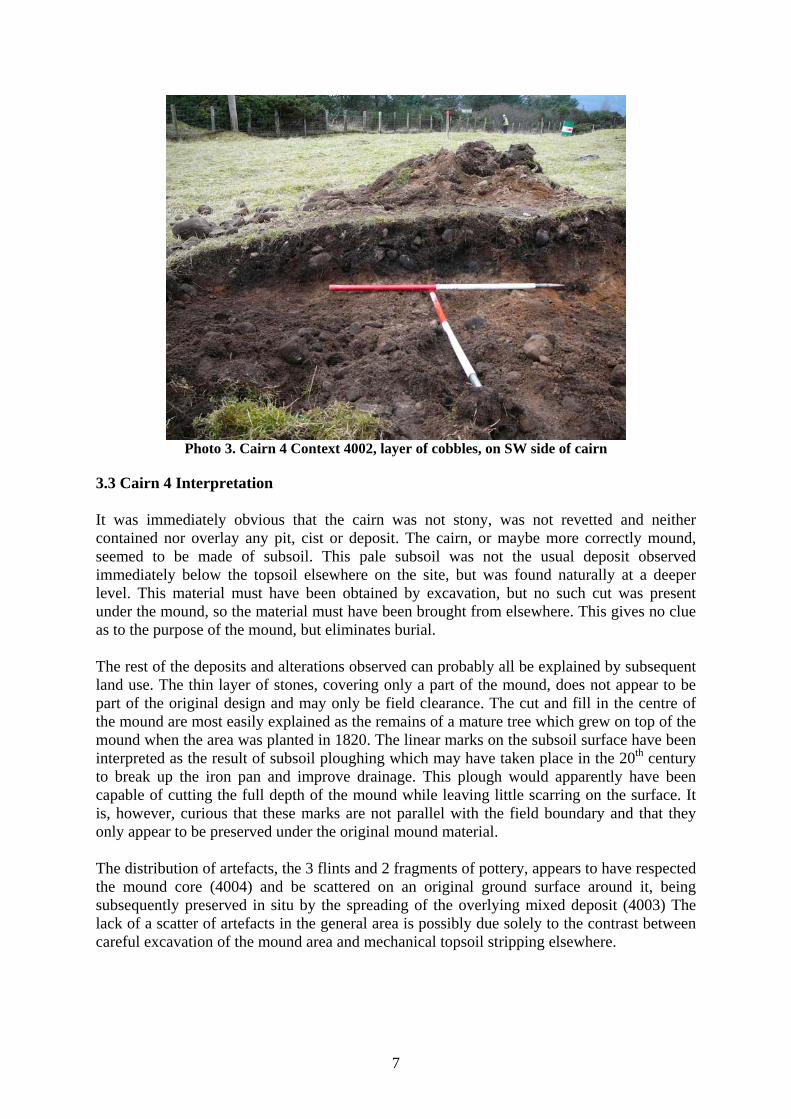
Photo 3. Cairn 4 Context 4002, layer of cobbles, on SW side of cairn
3.3 Cairn 4 Interpretation It was immediately obvious that the cairn was not stony, was not revetted and neither contained nor overlay any pit, cist or deposit. The cairn, or maybe more correctly mound, seemed to be made of subsoil. This pale subsoil was not the usual deposit observed immediately below the topsoil elsewhere on the site, but was found naturally at a deeper level. This material must have been obtained by excavation, but no such cut was present under the mound, so the material must have been brought from elsewhere. This gives no clue as to the purpose of the mound, but eliminates burial. The rest of the deposits and alterations observed can probably all be explained by subsequent land use. The thin layer of stones, covering only a part of the mound, does not appear to be part of the original design and may only be field clearance. The cut and fill in the centre of the mound are most easily explained as the remains of a mature tree which grew on top of the mound when the area was planted in 1820. The linear marks on the subsoil surface have been interpreted as the result of subsoil ploughing which may have taken place in the 20th century to break up the iron pan and improve drainage. This plough would apparently have been capable of cutting the full depth of the mound while leaving little scarring on the surface. It is, however, curious that these marks are not parallel with the field boundary and that they only appear to be preserved under the original mound material. The distribution of artefacts, the 3 flints and 2 fragments of pottery, appears to have respected the mound core (4004) and be scattered on an original ground surface around it, being subsequently preserved in situ by the spreading of the overlying mixed deposit (4003) The lack of a scatter of artefacts in the general area is possibly due solely to the contrast between careful excavation of the mound area and mechanical topsoil stripping elsewhere.

8
Cairn 4 Contexts Context no. Description Comments Interpretation 4001 Dark loam Uniform across cairn and
external ground surface Topsoil
4002 Cobbles, small to medium in size
Only observed on SW side of cairn
Possible later addition of field clearance stones
4003 Mixed pale brown soil-subsoil, matrix of 4002
Mounded over and to the side of 4004
Deposits 4001 and 4004 mixed by later land usage including ploughing
4004 Pale, fine sandy subsoil Compact mound in the centre of the spread cairn, observed in the E-facing section
Body of original cairn/mound
4005 cut Observed in E-facing section
Possible outline of tree root
4006 Dark black and dark brown homogenous sandy soil
Fill of 4005 Possible decayed tree root
4007 Thin black organic layer, no more than 3mm deep
Observed across entire exposed trench
Decayed vegetation
4008 Alternating black, orange, pale brown linear marks aligned 280º
Only observed beneath original cairn material
Uncertain, possible subsoil plough disturbance
4009 Orange-brown gritty-stony compacted surface
Observed across entire exposed area of trench
Natural subsoil surface
3.3 Excavation of Cairn 6 A slot trench measuring 800mm in width, 4m in length and aligned E-W was opened across the centre of this cairn, selected as it appeared to have a higher stone content than the others within the wayleave. While there proved to be a greater concentration of cobbles (6002) in the topsoil (6001), these again proved to be present only on the west side of the mound. The subsoil (6003) which formed the body of the mound and the matrix of some of the cobbles was not so clearly defined by colour change as in Cairn 4, appearing to be the same orange-brown gritty material as the natural subsoil surface. The same thin and patchy layer of black organic material, interpreted as decayed vegetation of a former ground surface (6004) was observed overlying the undisturbed subsoil surface (6007) and one fragment of coarse pottery was recovered from this interface. Immediately below the centre part of the mound a similar pattern of linear marks to Cairn 4 were present. This feature (6005) also aligned 280º consisted of a strip, 250mm wide, of soft, loose pale subsoil, appearing to be bounded by strips of black-brown fine, silty material (6006), incomplete and with a maximum width of 30mm. These strips when sectioned proved to be only 8mm deep, with a rounded base. The remaining north and south parts of the mound were removed mechanically during the watching brief, with nothing of archaeological significance being noted.

9
Photo 4. Cairn 6, removal of turf exposing stone layer on west side only
Photo 5. Cairn 6. Linear marks below mound
3.4 Cairn 6 Interpretation This cairn, while being broadly similar to Cairn 4, was dissimilar in that it had no distinct layer of pale, fine sandy subsoil which had formed the core of the mound of Cairn 4. There was no evidence for decayed tree roots in this cairn, which may indicate that the mounds were not deliberately targeted for planting, or even created as part of the planting process, in

10
1820. It must be significant, however, that the same linear marks appear under the centres of both cairns Cairn 6 Contexts Context no. Description Comments Interpretation 6001 Dark loam Uniform across cairn and
external ground surface Topsoil
6002 Cobbles, generally small to medium in size some larger, 200mm in length
Only observed on W side of cairn
Possible later addition of field clearance stones
6003 Stony orange-brown compacted subsoil
Compact mound in the centre of the spread cairn, observed in the E-facing section
Body of original cairn/mound
6004 Thin black organic layer, no more than 3mm deep
Observed across entire exposed trench
Decayed vegetation
6005 Linear marks aligned 280º
Observed under main body of mound
Uncertain, possible subsoil plough disturbance
6006 Black-brown fine silty material
strips defining edge of 6005
Uncertain, possible subsoil plough disturbance
6007 Orange-brown gritty-stony compacted surface
Observed across entire exposed area of trench
Natural subsoil surface
4.0 The Watching Brief In accordance with the WSI, after an examination of the results of the excavation of trenches through mounds 4 and 6, it was decided that the likelihood of internal features such as cists or burial deposits in the remaining mounds was low and that while all the archaeological team was on site, mechanical topsoil stripping could commence at the SE end of the wayleave. This would allow time and the resources to return to hand excavation if features of archaeological significance were exposed. 4.1 Cairns 2, 3, 5, 7, 8, 9, 10 These mounds were all low, fairly indistinct features which were only partially within the wayleave. Topsoil stripping exposed a section of each mound but left a part of it undisturbed, preserving them as landscape features and allowing the potential for future excavation. The mounds were investigated from SE to NW, in the order 10, 9, 8, 7, 5, 3, 2. with all members of the archaeological team taking turns to monitor work. All of these features proved to be low, spread, amorphous mounds overlying the natural orange-brown subsoil. The lower of the mounds consisted of no more than a slightly deeper topsoil with a scattered distribution of small cobbles, possibly placed over a natural rise in the subsoil. The larger mounds contained patches or lenses of a paler sandy subsoil, overlain by a layer of cobbles in a topsoil or mixed matrix, but with no structure and no uniformity of size
11
or shape. Below some of the mounds irregular patches of dark material, thought to be decayed vegetation representing an original ground surface, was observed. 4.2 Cairn 1 This was the only cairn entirely within the wayleave to be removed mechanically, and was also relatively large although irregular in shape. It was carefully removed a spit at a time by the machine. It proved to be slightly stonier than the more amorphous cairns, but again the main body of the mound was earth. The paler sandy mound core was evident and, under this, parallel marks similar to those observed in mounds 4 and 6. The exposed features were photographed but not drawn 4.2 Linear features. The SE linear feature, lying between mounds 6 and 7 was low and indistinct, spread to a width of 0.4m and rising to a maximum height of 0.3m. The two sections exposed by removal of the section within the wayleave indicated that it was not significantly stonier than the mounds and appeared to consist of the same earth-subsoil matrix. There was no internal structure. The NW linear feature, lying NW of mound 1, was equally indistinct but could be seen on the surface to be slightly sinuous. It was similar in width, 0.4m and slightly higher, to a maximum 0.4m. It also consisted of some stones within an earth-subsoil matrix and had no internal structure. 5.0 Small Finds Six artefacts were recovered during excavation of trenches 1 and 2. These consisted of three fragments of coarse, hand-made pottery and three flints. (See below, Appendix 1) All but SF6 were recovered from trench 1. Apart from SF1, which was found in disturbed topsoil, the artefacts all appeared to be located in the interface between the mixed soil-subsoil material, context 4003 in trench 1 and the topsoil-cobble layer in trench 2, contexts 6001 and 6002., and the natural subsoil, context 4009 and 6007. None were located beneath the core material of the mounds, context 4004 in trench 1 and 6003 in trench 2. There is no definite relationship between the artefacts and the putatively constructed core mounds, but they are sealed under what may be material added later. Without sampling other areas of the overall site, it is impossible to conclude that the distribution of artefacts is confined to under the spread mounds, as there may be a general scatter across the whole site, representing possible cultivation. The three fragments of pottery are non-diagnostic, consisting of small body sherds, undecorated, unburnished, with no impressions from vegetation. They demonstrate the typical variation in colour from orange-brown to black associated with poor, low-temperature firing. They are not, however, made of identical fabric. While SF 2 and 6 contain a significant number of mineral inclusions, including quartz and mica, SF4 appears to be relatively free of inclusions. This is also the thinnest body, only 6mm thick compared with the 12mm of SF2.

12
The thickness of SF 2 and the coarseness of the material could give this fragment the earlier date. However, only comparison with other locally-made fragments from secure contexts elsewhere along the Dornoch Firth will enable the time frame to be narrowed down. The three flints consist of two flakes and one fragment of a possible blade. None has been retouched, but the blade fragment has one highly polished edge, which suggests use as a tool. The two flakes are of a size and shape to have worked as scrapers, although there is no visible wear to confirm this. The colour of the flint varies, SF1 being deep red-brown, SF3 opaque honey brown and SF5 a pale brown. It is worth noting that nodules of flint occur naturally among the gravels of the Dornoch Firth. 6.0 Discussion The excavation and watching brief demonstrated that the mounds lying within the wayleave of the access road did not contain cists, burials or cremations, had no built structure and, given their lack of stone content, can not be described as cairns. At the most they are low mounds of subsoil lying directly on a former ground surface. However, no excavation into the ground to provide the subsoil was located and some of the subsoil, notably the fine pale sandy material of cairn 4, would appear to have been brought from a different or deeper source. The linear marks observed under the central part of cairns 1, 4 and 6 are difficult to interpret. If as suggested, they are marks left by a 20th century subsoil plough breaking up the iron pan to allow improved drainage, it seems unlikely that they could have passed across the highest point of each cairn without leaving a visible scar, which was not observed although other cairns did show evidence for attempts to plough through them, on a different alignment to these marks. It is also curious that while and area 4m by 3m was excavated to the same level in Cairn 4, the marks did not extend the full width of the trench, but only survived under the core material of the mound. There remains the possibility that they are marks of ploughing, but pre-dating the construction of the mounds, or of some other activity which was ‘closed’ by the mounds. The artefacts recovered from cairns 4 and 6 may allow a more precise dating of the activity at the time of the construction. These appear to have been scattered around the core of the mound, but none were recovered from under the core, so they are unlikely to pre-date its construction. They may have been associated with the activities at the ‘closure’ of the sites or may only be the surviving remains of a broad scatter of midden remains across cultivation areas, the rest having been disturbed by later land use. 7.0 Conclusions and Recommendations While it is unfortunate for the archaeological record that this part of the wider cairnfield had to be completely destroyed to allow the construction of the access road, the rest of the archaeological site remains intact for future recording and investigation. The results of this investigation are inconclusive, eliminating the interpretation as burial or cremation cairns but unable to provide a definitive explanation for their location or construction, or any firm

13
evidence for dating. The investigation has however provided the impetus for further archaeological investigation, which may be carried out by members of NoSAS with the support of the landowner. As the features within the wayleave have now been removed completely, no further archaeological work is considered necessary. Catherine Dagg 2, Ruigh’Riabhach Scoraig Peninsula Dundonnell Wester Ross IV23 2RE Tel: 01854 633 337 8.3.10 Acknowledgements The author would like to thank Mansefield Construction Ltd for their co-operation and assistance during the fieldwork, Tom Robb for access to the site Many thanks to Anne Coombs, Anne Johnstone and Alistair Jupp for cheerfully enduring the extreme cold.

14
Plan 1. Location of Features and Wayleave

15
Plan 2. Trench 1, Mound 4 A: West-facing section of original 4x3 trench B: West-facing section after extension of trench west by 0.5m

16
Plan 3. Trench 1, Mound 4 Ground Plan

17
Plan 4. Trench 2, Mound 6 A: South-facing section B: Ground Plan

18
Appendix 1. Small Finds Find no. Type Description Context Lithics 1 Flint Colour: red-brown
14mm long fragment of blade 21mm wide and 5mm thick. No obvious retouching, but highly polished edge suggests use.
Cairn 4 4007/4009
3 Flint Colour: honey brown Flake or base of blade with bulb of percussion, triangular in section 40mm long 20mm wide and 8mm thick
Cairn 4 4007/4009
5 Flint Colour: pale brown Curved flake, possible scraper 44mm long, 20mm wide and 6mm thick
Cairn 4 4007/4009
Ceramics 2 Pottery Broken into 2 fragments, originally 35m by 28m and
12mm thick. Dark brown exterior grading to chocolate brown inner face. Many pale, quartz-like inclusions, the largest 4mm wide
Cairn 4 4003
4 Pottery Broken into 2 fragments, originally 30mm by 18mm and 6mm thick. Chocolate brown colour, fine fabric with few inclusions
Cairn 4 4007/4007
6 Pottery One fragment, 18mm by 15mm and 8mm thick Dark brown inner and pale brown outer face, few inclusions
Cairn 6 6001/6003
Appendix 2: Timeline of Cartomie Wood 1808 George Brown’s survey for Balnagown Estate shows Gortomie, a small farm near the shoreline with 5 acres of arable and 12 acres of pasture and part of Gartomie, possessed by the minister with 7 acres of arable and 30 acres of pasture. The Gartomie farm buildings are depicted on this map down near the shore, with the patches of arable ground alos along the shore. The area containing the cairns is depicted as ‘Carrie Blair: thin stony moor with Broom yields little pasture’ c1820 whole area planted with Scots pine by Balnagown estate 1845 Woods depicted on Admiralty chart 1860s construction of railway through SW part of wood: In 1862 estate correspondence mentions 180 trees marked for sale, at a value of £57.3.4, and described as both blown over and standing. In 1865 290 fir trees are reported as having blown down. Both of these events are possibly connected with the building of the railway, which consists of a deep cut through the south of the woods, cutting Cartomie off from the standing stone and stone circle. 1875 Cartomie Wood depicted on 1st edition OS map as still fully wooded c1900 Sir Charles Ross of Balnagown felled the central part of the wood, leaving a belt around its perimeter to fool his mother passing on the train
19
c1900 onwards. Heather established well on the cut over woodland. This dry heather outrun used for turning the wintering hoggs out for the night off the arable of Ardmore farm c1906 Rifle Range constructed to east of wood 1942. All the trees in the remaining belt and south of the railway felled c 1980 Gregor MacKay, tenant of the croft of Broombank seeded the ground by burning off the heather and lime, fertilisers and seed broadcast on the bare surface with no ground breaking required Appendix 3 Photographic Record (digital) Photo no.
Trench no. Description Viewpoint
1 General view Site before marking out of wayleave. This runs parallel to the fence in the background, through the furthest visible mounds
From N
2 General View Site with wayleave marked out by red pegs. Plane table is set up on linear bank, cairn 4 is in background with tools, cairn 6 next to near right peg
From SE
3 Cairn 4 Trench 4m by 3m after removal of topsoil From E 4 Cairn 4 Trench 4m by 3m after removal of topsoil From SE 5 Cairn 4 East facing section, showing pale subsoil core of
mound (4004) cut by dark material, interpreted as tree root. Ground surface shows dark patches of 4006 and linear marks, visible as orange streak
From E
6 Cairn 4 East facing section and original ground surface From E 7 Cairn 4 Original ground surface and north facing section From N 8 Cairn 4 Linear marks, 4008, exposed after removal of core of
mound From W
9 Cairn 4 East facing section and linear marks, 4008, on original ground surface. Dark black material in section is interpreted as decayed tree root
From E
10 Cairn 4 Partial removal of linear marks, 4008, to reveal underlying natural subsoil surface 4009
From E
11 Cairn 4 East facing section and linear marks removed to expose natural subsoil surface
From E
12 Cairn 4 East facing section, pale subsoil of mound core flanking dark material of decayed tree root
From E
13 Cairn 4 Cairn or mound after east half removed From SE 14 Cairn 4 Cairn or mound after east half removed From NE 15 Cairn 4 Trench extended W by 500mm, east facing section,
central section From E
16 Cairn 4 Trench extended west, new east facing section showing layer of cobbles in topsoil on south side of mound
From NE
17 Cairn 4 Trench extended west, new east facing section showing layer of cobbles in topsoil on south side of mound
From SE
18 Cairn 4 Trench extended west, new east facing section showing layer of cobbles in topsoil on south side of
From E

20
mound 19 Cairn 6 Trench 0.5m by 2m after topsoil stripping, showing
relationship to Cairn 4 in background From SE
20 Cairn 6 Trench 0.5m by 2m after topsoil stripping, aligned E-W
From W
21 Cairn 6 Trench after cleaning down to cobble layer present on west side of mound
From W
22 Cairn 6 Ranging pole marks centre line of mound, showing cobble layer to west, absent to East
From N
23 Cairn 6 Ranging pole marks centre line of mound, showing cobble layer to west, absent to East
From SE
24 Cairn 6 South facing section showing cobble content to west side of mound
From S
25 Cairn 6 South facing section showing cobble content to west side of mound
From SW
26 Cairn 6 South facing section showing cobble content to west side of mound
From SE
27 Cairn 6 South facing section, detail of cobble content From S 28 Cairn 6 Linear marks, 6005, aligned 280º, photo taken with
flash From S
29 Cairn 6 Linear marks, 6005, aligned 280º, photo taken without flash
From S
30 Cairn 10 NE facing section of cairn cut by topsoil removal From NE 31 Cairn 10 NE facing section of cairn cut by topsoil removal From E 32 Cairn 10 NE facing section of cairn cut by topsoil removal From N 33 SF 1 Flint, fragment of blade 34 SF3 Flint, fragment of blade or flake 35 SF5 Flint flake, possible scraper, outer face 36 SF5 Flint flake, possible scraper, inner face 37 SF 2 Pottery, outer face 38 SF2 Pottery, inner face 39 SF6 Pottery fragment, inner face 40 SF6 Pottery fragment, outer face 41 SF4 Pottery fragment, outer face 42 SF4 Pottery fragment, inner face.