Embed Size (px)
Citation preview
Carolina Beach State Park
General Management Plan
North Carolina Department of Natural and Cultural Resources
Division of Parks and Recreation
Coastal Region
January 2017

2
I. MISSION AND PURPOSE
MISSION STATEMENT:
Conservation: To protect North Carolina’s natural diversity through careful selection and
stewardship of state parks system lands;
Recreation: To provide and promote outdoor recreation opportunities in the state parks
system and throughout the state; and
Education: To encourage appreciation of North Carolina’s natural and cultural heritage
through diverse educational opportunities; for all citizens of and visitors to the State of
North Carolina.
Our purpose: The State of North Carolina offers unique archaeologic, geologic, biologic,
scenic and recreational resources. These resources are part of the heritage of the people of
this State. The heritage of a people should be preserved and managed by those people for
their use and for the use of their visitors and descendants.
PARK PURPOSE
Carolina Beach State Park was established in 1969 to preserve unique environment and diverse
natural communities. It also provides recreational activities in a coastal environment. Snow’s
Cut, which forms the northern boundary of the park, was dredged in 1929 to connect Masonboro
Sound with the Cape Fear River as part of the Atlantic Intracoastal Waterway. A significant
portion of the park land is leased from the U.S. Army. The first 291 acres were acquired and
funded by the first General Assembly appropriation for state park land acquisition since the
purchase of Mount Mitchell in 1916.
Thirteen natural communities, including the only protected Coastal Fringe Evergreen Forest
community in the state, makes this one of the most diverse sites in the State Parks System and
contributes to its statewide significance. Several species of carnivorous plants are found at
Carolina Beach State Park, including the Venus’ Flytrap, found only within 75 miles of the park.
The beaches, ponds and woods are home to many animal species: birds - such as brown pelicans,
ospreys and painted buntings; larger mammals - such as river otter, white-tailed deer and raccoons;
and reptiles and amphibians - such as skinks, anoles and the rare eastern coral snake.
Opportunities to view many natural communities in one location and enjoy water-based recreation
are significant resources at Carolina Beach State Park. Recreational uses should be compatible
with the protection of the outstanding natural resources. Fishing, hiking, picnicking and boating
are popular activities for visitors, and family and group campsites accommodate overnight visitors.
Boat ramps and amenities for boaters are provided at the marina. From the park, boaters can access
the estuarine waters of the Cape Fear River and Masonboro Sound, and the salt waters of the
Atlantic Ocean.
The underlying geology at Carolina Beach State Park contributes to the presence of the large
number of natural communities. The dry, coarse soil of a series of stabilized east-west trending
relic sand dunes of Pleistocene age hosts forests of Turkey Oak, Live Oak and Longleaf Pine.
Dense shrub swamps called pocosins occur between the dunes. A series of small shallow ponds
are sinkholes in the Pleistocene coquina or shell limestone that underlies the park, formed when
3
groundwater dissolves and weakens the limestone. These lime sink ponds are each vegetated by
a unique plant community, and the acidic, mineral-poor boggy soils provide the ideal environment
for several interesting carnivorous plants to thrive.
Over seven miles of trails and boardwalks provide the visitor with excellent places for watching
birds, exploring tidal marshes and creeks, and experiencing the many natural communities and
unique carnivorous plants found at Carolina Beach State Park. Locations along Sugarloaf Trail
and Sugarloaf Dune provide scenic views of the natural landscape of the Cape Fear River, several
river islands, watercraft, and the mainland beyond.
Prior to European settlement, Cape Fear Indians lived in and around the area that is now Carolina
Beach State Park, and artifacts of their culture that have been found here include pottery fragments,
arrowheads and shell middens. In 1726, permanent colonial settlement was established and the
Cape Fear River became an official port of entry for commerce, supporting the local economy of
agricultural and timber products, naval stores, shipping, and trade. Sugarloaf, a 50-foot high sand
dune near the bank of the Cape Fear River, was of strategic significance during the siege of Fort
Fisher near the end of the Civil War.
Carolina Beach State Park exists primarily for its outstanding biological, recreational and geologic
resources, and also for its scenic and archaeological significance. The Division of Parks and
Recreation is charged with preserving these values and providing park experiences that promote
pride in and understanding of the natural heritage.

4
II. HISTORY
The Cape Fear Indians lived in and around
the area that is now Carolina Beach State
Park, prior to European settlement.
Mainly occupying the land along the Cape
Fear River and its tributaries, the small
tribe grew hostile to early settlers and, in
1715, participated in an uprising against
Europeans in the area. The Cape Fear
Indians were defeated and left the area by
1725. Artifacts of the native culture,
including pottery fragments, arrowheads,
and mounds of oyster shells have been
found in the area.
Early attempts at colonization in the area
were unsuccessful, mainly due to conflicts with the Cape Fear Indians. Pirating, common in the
area during colonial times, also contributed to the struggles of early settlers. In 1726, a permanent
settlement was established along the Lower Cape Fear. The newly settled land became an
important arena for commerce when the English Crown designated the Cape Fear River as one of
five official ports of entry. Agricultural, timber products, naval stores, shipping, and trade formed
the basis of the economy.
Sugarloaf, a 50-foot sand dune near the bank of the Cape Fear River, has been an important
navigational marker for river pilots since 1663. The dune was also of strategic significance during
the Civil War when, as part of the Confederacy's defense of the Port of Wilmington, about 5,000
troops camped on or near Sugarloaf during the siege of Fort Fisher.
Carolina Beach State Park was established in 1969 to preserve the unique environment along the
intracoastal waterway.
The park is located on a triangle of land known
as Pleasure Island, which lies between the
Atlantic Ocean and the Cape Fear River. The
land became an island when Snow's Cut was
dredged in 1929 and 1930, connecting
Masonboro Sound to the Cape Fear River.
Snow's Cut, a part of the Intracoastal Waterway,
provides inland passage for boat traffic along the
Atlantic coast.
As of June 30, 2016, Carolina Beach State Park
manages 627.61 acres.
Marsh
Visitor Center

5
III. THEMES AND INVENTORY
Carolina Beach State Park Theme Table
Theme Type Theme Carolina
Beach Significance
State Parks System
Representation Archeological/Historic Military High Adequate
Archeological/Historic Rural-Domestic High Adequate
Archeological/Prehistoric Campsite/Activity Area High Adequate
Archeological/Prehistoric Underwater High Adequate
Biological Coastal Plain Depression Communities
High Moderate
Biological Dry Longleaf Pine Communities High Moderate
Biological Estuarine Communities High Adequate
Biological Maritime Forests High Moderate
Biological Peat Dome Pocosins High Moderate
Biological Streamhead Pocosins Little Little
Biological Wet Pine Savannas High Moderate
Geological Caves, Sinks, and Springs High Adequate
Geological Natural Lakes and Ponds High Adequate
Geological Relic Coastal Features High Little
Scenic Bays/Estuaries High Little
Scenic Forests High Moderate
Scenic Islands High Little
Scenic Marshes High Moderate
Scenic Meadows/Grasslands High Little
Scenic Reservoirs/Lakes High Moderate
Scenic Rivers High Little
Scenic Scenic Vistas High Moderate
Scenic Seashores High Moderate
Scenic Swamps High Adequate
*See the System wide Plan for references to Theme and Inventory terms. Themes have both actual
and “potential” future needs to be at a park.

6
FACILITY INVENTORY
CAROLINA BEACH STATE PARK
CAPE FEAR RIVER
7
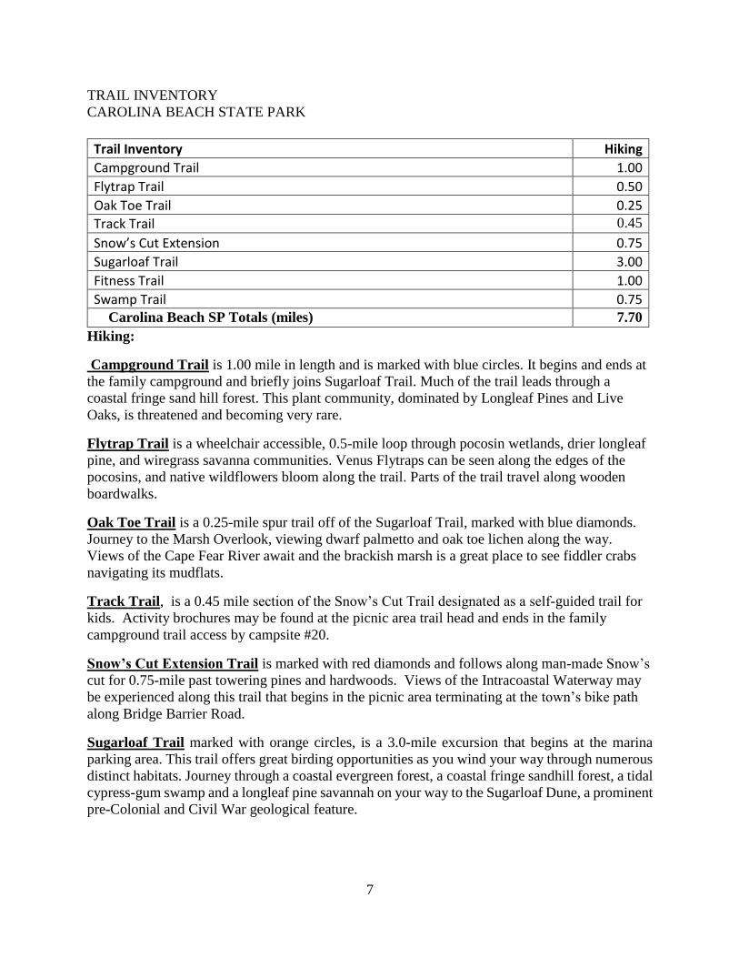
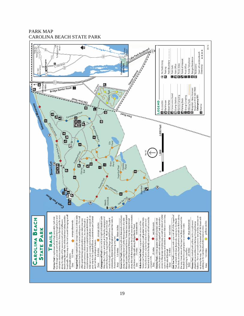
TRAIL INVENTORY
CAROLINA BEACH STATE PARK
Hiking:
Campground Trail is 1.00 mile in length and is marked with blue circles. It begins and ends at
the family campground and briefly joins Sugarloaf Trail. Much of the trail leads through a
coastal fringe sand hill forest. This plant community, dominated by Longleaf Pines and Live
Oaks, is threatened and becoming very rare.
Flytrap Trail is a wheelchair accessible, 0.5-mile loop through pocosin wetlands, drier longleaf
pine, and wiregrass savanna communities. Venus Flytraps can be seen along the edges of the
pocosins, and native wildflowers bloom along the trail. Parts of the trail travel along wooden
boardwalks.
Oak Toe Trail is a 0.25-mile spur trail off of the Sugarloaf Trail, marked with blue diamonds.
Journey to the Marsh Overlook, viewing dwarf palmetto and oak toe lichen along the way.
Views of the Cape Fear River await and the brackish marsh is a great place to see fiddler crabs
navigating its mudflats.
Track Trail, is a 0.45 mile section of the Snow’s Cut Trail designated as a self-guided trail for
kids. Activity brochures may be found at the picnic area trail head and ends in the family
campground trail access by campsite #20.
Snow’s Cut Extension Trail is marked with red diamonds and follows along man-made Snow’s
cut for 0.75-mile past towering pines and hardwoods. Views of the Intracoastal Waterway may
be experienced along this trail that begins in the picnic area terminating at the town’s bike path
along Bridge Barrier Road.
Sugarloaf Trail marked with orange circles, is a 3.0-mile excursion that begins at the marina
parking area. This trail offers great birding opportunities as you wind your way through numerous
distinct habitats. Journey through a coastal evergreen forest, a coastal fringe sandhill forest, a tidal
cypress-gum swamp and a longleaf pine savannah on your way to the Sugarloaf Dune, a prominent
pre-Colonial and Civil War geological feature.
Trail Inventory Hiking
Campground Trail 1.00
Flytrap Trail 0.50
Oak Toe Trail 0.25
Track Trail 0.45
Snow’s Cut Extension 0.75
Sugarloaf Trail 3.00
Fitness Trail 1.00
Swamp Trail 0.75 Carolina Beach SP Totals (miles) 7.70

8
Fitness Trail marked with yellow circles, is a wheelchair-accessible one-mile loop through
diverse habitats. There are several exercise and activity stations set up along the way. This trail is
located off of 7th Street with parking at the Carolina Beach Recreation Center.
Swamp Trail is a three-quarter-mile trail marked with red circles, begins and ends along
Sugarloaf Trail. It provides access to the group camping areas as well as views of a tidal cypress-
gum swamp and brackish marsh that are seen along either side of the trail.

9
TRAIL INVENTORY
CAROLINA BEACH STATE PARK
CAPE FEAR RIVER
COAST GUARD
PROPERTY

10
IV. PLANNING

11
LAND PROTECTION PLAN
CAROLINA BEACH STATE PARK
COAST GUARD
PROPERTY

12
LAND PROTECTION PLAN
CAROLINA BEACH STATE PARK
TRAILS, LIME SINK
PONDS, AND PARK
EXPANSION TO ROAD
COAST GUARD
PROPERTY
LEASED
LAND
MAIN
ENTRANCE

13
FEDERAL LEASE AREA
CAROLINA BEACH STATE PARK
COAST GUARD
PROPERTY

14
PROJECT EVALUATION PROGRAM LIST
CAROLINA BEACH STATE PARK
Project # Project Title Cost
1 Two Picnic Shelters and Parking Improvements $305,200
2 Tent/Trailer Campground Improvements $904,179
3 Maintenance Area Improvements $953,037
TOTAL $2,162,416 ** Estimated project cost does not include contingencies, design fee, nor escalation.
1. Two Picnic Shelters and Parking Improvements
Included are construction of two eight-table picnic shelters, one located in the picnic area
and one at the marina area. The picnic area parking lot scope of work includes additional
20 parking spaces. The contractor will repave entire parking lot after the proposed spaces
are installed. Construction of the marina area picnic shelter is needed, but a nautical
flagpole was installed at the high point of the site.
2. Tent/Trailer Campground Improvements
Nine (9) existing campsites in Loop 1 will be
converted to full “3 point” hook up capability
(water, sewer, electricity) for sites # 2,
4,5,7,8,10,12,14,15.
Funding is needed to complete entire Loop 1
amenities. Loop 2 will remain primitive
camping without hookups.
Loop 2 campsites need tent pad borders and
renovation of each shower house is necessary.
The Loop 2 dump station needs repair. The
demand for more RV sites and recent project
to tie the parks sewer into the local municipal
system may make re-establishing of Loop 2
dump station easier to accomplish. An automated gate is needed for camper and boater
convenience.
The two shower houses will be renovated to meet current building and universal codes or
replaced with new construction. A decision on renovation versus replacement feasibility
will be made at the time of project funding. Additional funds may be required to
demolish the old structures and build proposed structures.
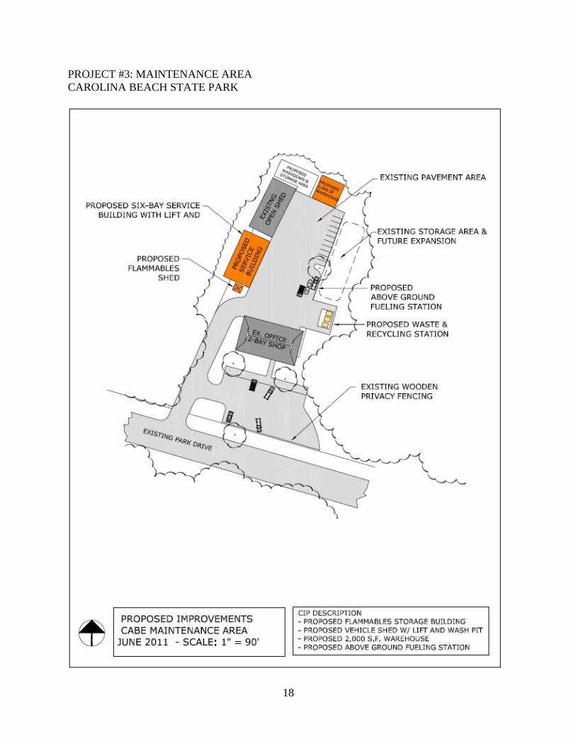
3. Maintenance Area Improvements
The project includes industrial equipment, a flammable storage building, vehicle shed,
vehicle lift and vehicle wash station.
The removal of the existing underground fuel tank and installation an above ground 1,000-
Primitive campground

15
gallon fuel tank and fuel point has been approved for major maintenance
.
Pole Barn at Maintenance area

16
PROJECT #1: PICNIC SHELTER
CAROLINA BEACH STATE PARK

17
PROJECT #1: PARK SHELTERS
CAROLINA BEACH STATE PARK
NORTH
18
PROJECT #3: MAINTENANCE AREA
CAROLINA BEACH STATE PARK
19
PARK MAP
CAROLINA BEACH STATE PARK