Embed Size (px)
Citation preview

37. SEISMIC STRATIGRAPHY AND GEOLOGIC DEVELOPMENT OF AN OPEN-OCEANCARBONATE SLOPE: THE NORTHERN MARGIN OF LITTLE BAHAMA BANK1'2
H. Mark Van Buren, Department of Geology and Moss Landing Marine Laboratories, San Jose State University,San Jose, California
andHenry T. Mullins, Department of Geology, Heroy Geology Laboratory, Syracuse University, Syracuse, New York
ABSTRACT
Carbonate slope development north of Little Bahama Bank (LBB) has been investigated via a seismic stratigraphicanalysis of approximately 1350 km of air-gun seismic reflection profiles. Slope development is shown to be complex be-cause of the interaction of slope accretion, sediment bypassing, and submarine erosion to produce a single open-oceancarbonate slope. The present slope north of LBB did not develop until after the complete drowning of the southernBlake Plateau near the end of the Cretaceous. Beginning in the early Tertiary and continuing through the present, thisslope has accreted laterally by the accumulation of periplatform oozes along its upper slope, whereas submarine slidesand sediment gravity flows have bypassed the upper slope, resulting in a lower slope apron of slide blocks, turbidites,and debris flows. Slope sedimentation north of LBB was more or less continuous, with the exception of a late Oligoceneerosional event that may be correlative with the "Au" unconformity in the western North Atlantic.
Overall, slope accretion, sediment bypassing, and submarine erosion have acted together during plate tectonic driftto higher latitudes, numerous sea-level fluctuations, and local tectonics to produce a single, open-ocean carbonateslope. This area is well-suited for future Deep Sea Drilling Project drill sites to evaluate the demise of a shallow-watercarbonate platform and subsequent carbonate slope development.
INTRODUCTION
The geologic development of carbonate slopes is oneof the least-known aspects of the overall evolution ofcarbonate platforms. In "modern" environments, pre-vious studies of carbonate slopes (Mullins and Neu-mann, 1979; Schlager and Chermak, 1979; Mullins etal., 1980a, 1980b; Crevello and Schlager, 1980) haveconcentrated on lateral facies relationships, and havebeen limited by the relative inaccessability of these deep-water environments to direct observations, as well as byrelatively steep gradients that limit the resolution capa-bilities of conventional seismic reflection profilers.
In an attempt to conceptualize carbonate slope devel-opment, Mullins and Neumann (1979) proposed a clas-sification of carbonate slopes that was based on: (1)whether a particular slope is presently accreting or erod-ing; (2) whether the accretion is lateral or extensional;(3) whether lateral growth occurs along the open ocean,and open seaway, or a closed seaway; and (4) whetherthe slope is adjacent to a windward or leeward-orientedshallow-bank edge (with respect to the physical energyflux at the sea surface). This latter point is of significanceto the supply of coarse-grained sediment from the banktop to the adjacent slope, which Hine et al. (1981) havedemonstrated to be extensive along leeward bank mar-gins.
Schlager and Ginsburg (1981) have recently proposeda developmental scheme for carbonate slopes that utiliz-
Sheridan, R. E., Gradstein, F. M., et al., Init. Repts. DSDP, 76: Washington (U.S.Govt. Printing Office).
2 Please direct all correspondence, including requests for reprints, to Dr. Mullins atSyracuse University.
es the accreting and eroding types of Mullins and Neu-mann (1979) as well as the bypass type of Schlager andChermak (1979). On the basis of slope profile, Schlagerand Ginsburg (1981) suggest that during the evolutionof carbonate platforms, carbonate slopes evolve natu-rally from accretion to bypassing to erosion types. Ac-cretion slopes have gentle profiles that suggest outbuild-ing by submarine slump and debris-flow processes; alongbypass slopes, turbidity current processes dominate asthe overall slope profile increases; and erosion slopesevolve from bypass slopes as a result of erosion by tur-bidity currents that outpace perennial sedimentation(Schlager and Ginsburg, 1981).
The location of our present study area is illustrated inFigure 1. Sedimentologically, this slope north of LittleBahama Bank (LBB) is an excellent example of a bypassslope (Mullins and Neumann, 1979), yet its overall slopeprofile is, for the most part, similar to those classified asaccretion slopes by Schlager and Ginsburg (1981). Previ-ous work on this slope by Mullins and Neumann (1979)was based on only a few reflection profiles and a hand-ful of cores. We returned to this slope to conduct a de-tailed investigation in order to understand more fullythe geologic development of carbonate slopes. In thischapter we concentrate on the geologic development ofthis slope, principally focussing on a stratigraphic anal-ysis of our seismic reflection data. Details of our sedi-mentological studies have been (Mullins, Newton, et al.,1981) or are in the process of being presented elsewhere.
METHODSApproximately 1350 km of high-resolution, single-channel, air-
gun, seismic reflection profiles were collected from the slope north ofLBB. A grid of track lines, with an approximate spacing of 5 km, was
749

H. M. VAN BUREN, H. T. MULLINS
Figure 1. Index map of the Blake Plateau-northern Bahama Platform region. (Note location of study areaand its relationship to the Great Abaco Canyon [GAC]. Also shown are locations of JOIDES [J-l toJ-6] and DSDP [390-392; 534] drill holes, as well as the multichannel seismic line [UTMSI] of Shipleyet al. [1978]. Distribution of Miocene gravity flow deposits in the Blake-Bahama Basin [heavy dashedline] is based on Benson, Sheridan, et al. [1978]. Islands are in black. GBB Great Bahama Bank;LBB = Little Bahama Bank; NEPC = Northeast Providence Channel. Based on King [1969].)
run both parallel and perpendicular to the northern shelf edge of LBBin order to facilitate seismic stratigraphic correlations (Fig. 2). Seismicreflection, total intensity magnetic, and 3.5-kHz PDR (precision depthrecorder) profiles were collected simultaneously along track lines. Re-flection profiles were obtained aboard the Eastward in July throughAugust 1979 by the firing of a single 5-in.3 air gun every 3 s. Reflec-tions were received by a single-channel streamer equipped with a pre-amplifier, filtered at 63/205 Hz, and graphically recorded.
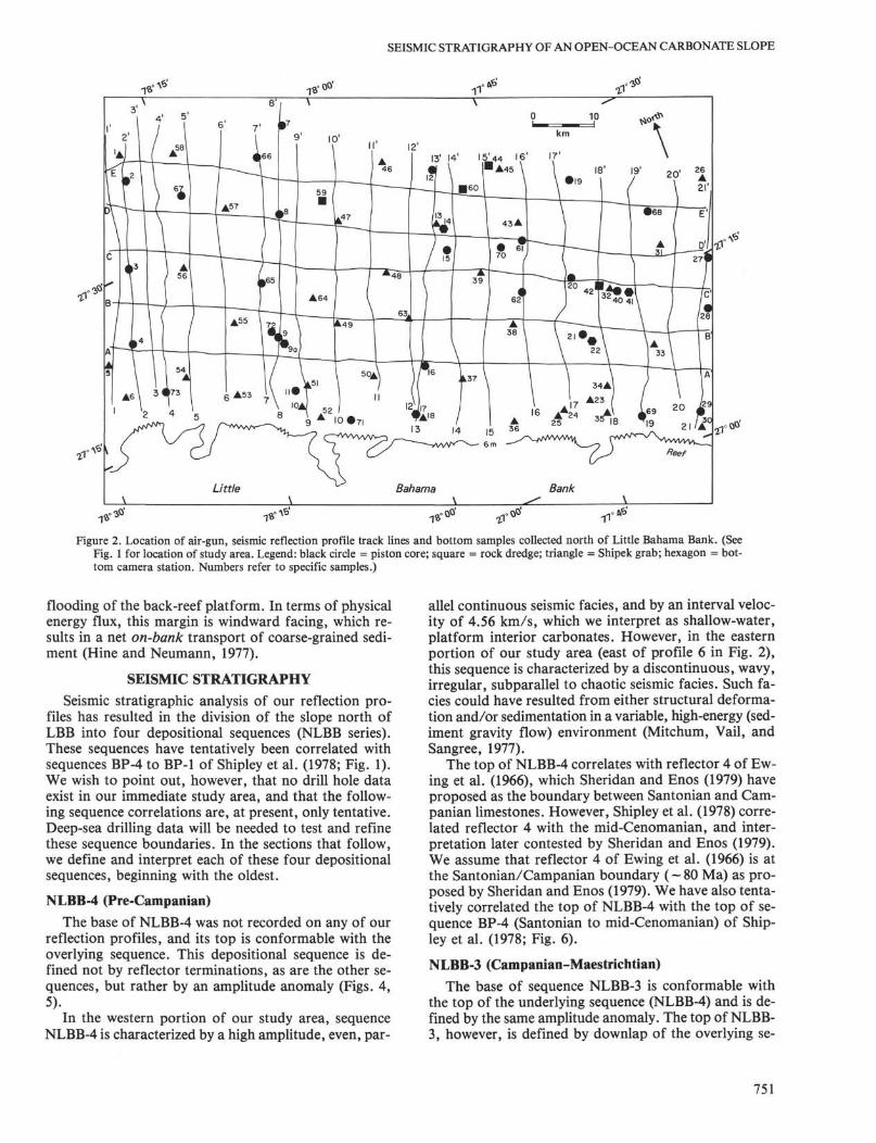
Seismic stratigraphic analyses are based on criteria in Payton(1977). Depositional sequence boundaries (i.e., unconformities) aredefined by reflector terminations (onlap, downlap, truncation) when-ever possible (Mitchum, Vail, and Thompson, 1977) and then com-pared with the global sea-level curve of Vail et al. (1977) for possiblecorrelations. Seismic facies are identified and interpreted using reflec-tion parameters such as configuration, continuity, amplitude, fre-quency, and interval velocity (Mitchum, Vail, and Sangree, 1977; San-gree and Widmier, 1977; Sheridan, 1981). Interval velocities are basedon comparison of our reflection profiles with available refraction data(profile 21 of Sheridan et al., 1966). Major reflectors are identified bycomparison with profiles presented in Ewing et al. (1966) and thencorrelated with available drill hole data (JOIDES, 1965; Sheridan andEnos, 1979), as well as with preexisting seismic stratigraphic unitsdefined for the northern Blake Plateau (Fig. 1; Shipley et al., 1978). Inaddition to geophysical profiles, we have also collected 73 bottomsamples from this study area (Fig. 2), some of which were previouslyreported in Mullins and Neumann (1979).
REGIONAL SETTING
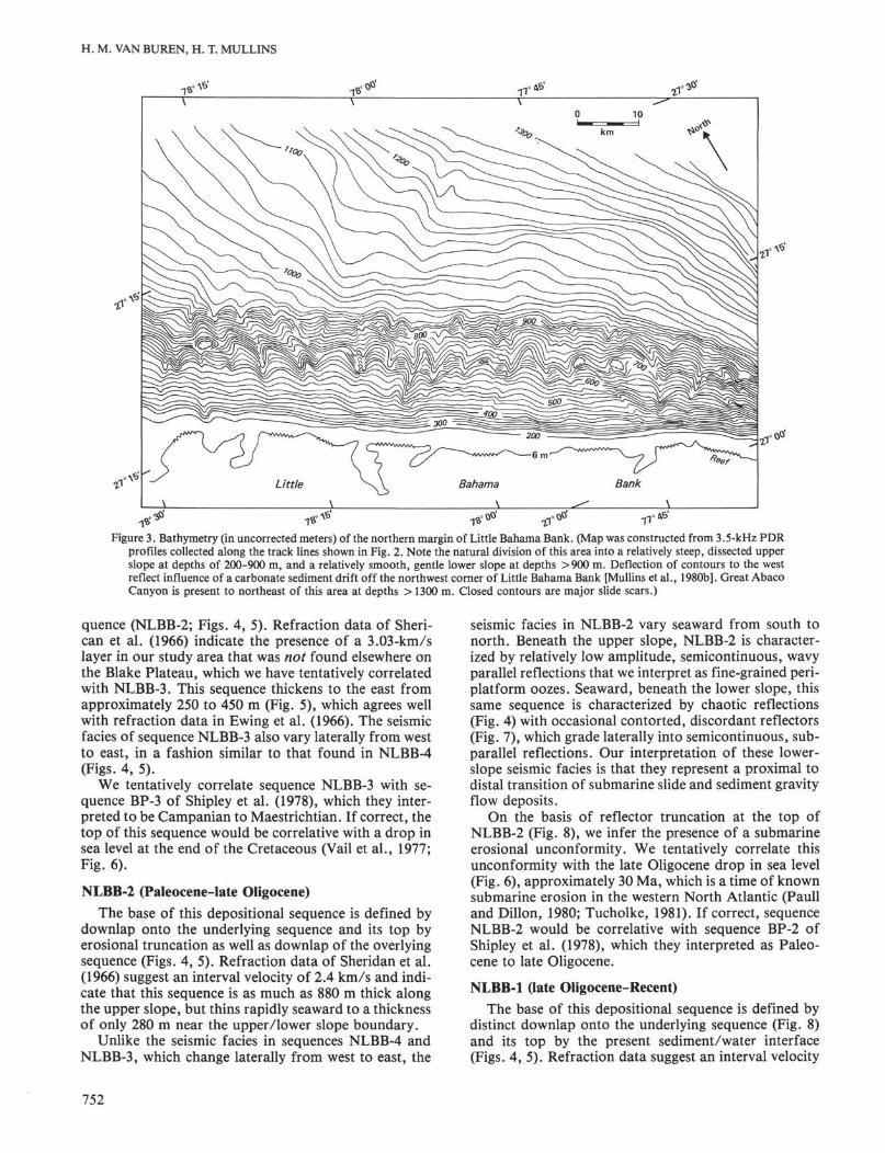
The northern margin of LBB marks the present-daytopographic boundary between the relatively deep-waterBlake Plateau on the north and the shallow-water Baha-ma Platform to the south (Fig. 1). Morphologically, thismargin can be divided into a relatively steep ( — 4°) up-per slope (200-900 m), dissected by numerous slope gul-lies or canyons, and a more gentle (~ 1-2°) lower slope(900-1300+ m) or basin margin rise (Fig. 3).
Northeast of LBB lies the Great Abaco Canyon,whose location and origin have been linked to the GreatAbaco Fracture Zone (Sheridan and Osburn, 1975; Ben-son, Sheridan, et al., 1978; Mullins et al., 1982). ThisCanyon extends from depths of ~ 1300 m north of LBBto below 4800 m in the adjacent Blake-Bahama Basin(Fig. 1).
The shallow-bank edge of northern LBB is basically areef-dominated margin with numerous back-reef sandshoals and lagoons (Hine and Neumann, 1977; Locker,1980). However, Lighty (1981) has shown that this bar-rier reef died approximately 3500 yr. ago due to initial
750
SEISMIC STRATIGRAPHY OF AN OPEN-OCEAN CARBONATE SLOPE
Figure 2. Location of air-gun, seismic reflection profile track lines and bottom samples collected north of Little Bahama Bank. (SeeFig. 1 for location of study area. Legend: black circle = piston core; square = rock dredge; triangle = Shipek grab; hexagon = bot-tom camera station. Numbers refer to specific samples.)
flooding of the back-reef platform. In terms of physicalenergy flux, this margin is windward facing, which re-sults in a net on-bank transport of coarse-grained sedi-ment (Hine and Neumann, 1977).
SEISMIC STRATIGRAPHY
Seismic stratigraphic analysis of our reflection pro-files has resulted in the division of the slope north ofLBB into four depositional sequences (NLBB series).These sequences have tentatively been correlated withsequences BP-4 to BP-1 of Shipley et al. (1978; Fig. 1).We wish to point out, however, that no drill hole dataexist in our immediate study area, and that the follow-ing sequence correlations are, at present, only tentative.Deep-sea drilling data will be needed to test and refinethese sequence boundaries. In the sections that follow,we define and interpret each of these four depositionalsequences, beginning with the oldest.
NLBB-4 (Pre-Campanian)
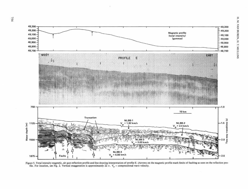
The base of NLBB-4 was not recorded on any of ourreflection profiles, and its top is conformable with theoverlying sequence. This depositional sequence is de-fined not by reflector terminations, as are the other se-quences, but rather by an amplitude anomaly (Figs. 4,5).
In the western portion of our study area, sequenceNLBB-4 is characterized by a high amplitude, even, par-
allel continuous seismic facies, and by an interval veloc-ity of 4.56 km/s, which we interpret as shallow-water,platform interior carbonates. However, in the easternportion of our study area (east of profile 6 in Fig. 2),this sequence is characterized by a discontinuous, wavy,irregular, subparallel to chaotic seismic facies. Such fa-cies could have resulted from either structural deforma-tion and/or sedimentation in a variable, high-energy (sed-iment gravity flow) environment (Mitchum, Vail, andSangree, 1977).
The top of NLBB-4 correlates with reflector 4 of Ew-ing et al. (1966), which Sheridan and Enos (1979) haveproposed as the boundary between Santonian and Cam-panian limestones. However, Shipley et al. (1978) corre-lated reflector 4 with the mid-Cenomanian, and inter-pretation later contested by Sheridan and Enos (1979).We assume that reflector 4 of Ewing et al. (1966) is atthe Santonian/Campanian boundary (-80 Ma) as pro-posed by Sheridan and Enos (1979). We have also tenta-tively correlated the top of NLBB-4 with the top of se-quence BP-4 (Santonian to mid-Cenomanian) of Ship-ley et al. (1978; Fig. 6).
NLBB-3 (Campanian-Maestrichtian)The base of sequence NLBB-3 is conformable with
the top of the underlying sequence (NLBB-4) and is de-fined by the same amplitude anomaly. The top of NLBB-3, however, is defined by downlap of the overlying se-
751
H. M. VAN BUREN, H. T. MULLINS
Figure 3. Bathymetry (in uncorrected meters) of the northern margin of Little Bahama Bank. (Map was constructed from 3.5-kHz PDRprofiles collected along the track lines shown in Fig. 2. Note the natural division of this area into a relatively steep, dissected upperslope at depths of 200-900 m, and a relatively smooth, gentle lower slope at depths >900 m. Deflection of contours to the westreflect influence of a carbonate sediment drift off the northwest corner of Little Bahama Bank [Mullins et al., 1980b]. Great AbacoCanyon is present to northeast of this area at depths > 1300 m. Closed contours are major slide scars.)
quence (NLBB-2; Figs. 4, 5). Refraction data of Sheri-can et al. (1966) indicate the presence of a 3.03-km/slayer in our study area that was not found elsewhere onthe Blake Plateau, which we have tentatively correlatedwith NLBB-3. This sequence thickens to the east fromapproximately 250 to 450 m (Fig. 5), which agrees wellwith refraction data in Ewing et al. (1966). The seismicfacies of sequence NLBB-3 also vary laterally from westto east, in a fashion similar to that found in NLBB-4(Figs. 4, 5).
We tentatively correlate sequence NLBB-3 with se-quence BP-3 of Shipley et al. (1978), which they inter-preted to be Campanian to Maestrichtian. If correct, thetop of this sequence would be correlative with a drop insea level at the end of the Cretaceous (Vail et al., 1977;Fig. 6).
NLBB-2 (Paleocene-late Oligocene)The base of this depositional sequence is defined by
downlap onto the underlying sequence and its top byerosional truncation as well as downlap of the overlyingsequence (Figs. 4, 5). Refraction data of Sheridan et al.(1966) suggest an interval velocity of 2.4 km/s and indi-cate that this sequence is as much as 880 m thick alongthe upper slope, but thins rapidly seaward to a thicknessof only 280 m near the upper/lower slope boundary.
Unlike the seismic facies in sequences NLBB-4 andNLBB-3, which change laterally from west to east, the
seismic facies in NLBB-2 vary seaward from south tonorth. Beneath the upper slope, NLBB-2 is character-ized by relatively low amplitude, semicontinuous, wavyparallel reflections that we interpret as fine-grained peri-platform oozes. Seaward, beneath the lower slope, thissame sequence is characterized by chaotic reflections(Fig. 4) with occasional contorted, discordant reflectors(Fig. 7), which grade laterally into semicontinuous, sub-parallel reflections. Our interpretation of these lower-slope seismic facies is that they represent a proximal todistal transition of submarine slide and sediment gravityflow deposits.
On the basis of reflector truncation at the top ofNLBB-2 (Fig. 8), we infer the presence of a submarineerosional unconformity. We tentatively correlate thisunconformity with the late Oligocene drop in sea level(Fig. 6), approximately 30 Ma, which is a time of knownsubmarine erosion in the western North Atlantic (Paulland Dillon, 1980; Tucholke, 1981). If correct, sequenceNLBB-2 would be correlative with sequence BP-2 ofShipley et al. (1978), which they interpreted as Paleo-cene to late Oligocene.
NLBB-1 (late Oligocene-Recent)The base of this depositional sequence is defined by
distinct downlap onto the underlying sequence (Fig. 8)and its top by the present sediment/water interface(Figs. 4, 5). Refraction data suggest an interval velocity
752

North 9 * ' -
SEISMIC STRATIGRAPHY OF AN OPEN-OCEAN CARBONATE SLOPE
| ' ' | SouthProfile 4
375-
750
•BQ.
1125
1500- -2.0
Figure 4. Photograph and line drawing interpretation of air-gun reflection profile 4. (For location of profile, see Fig.2. Mj and M2 denote first and second water bottom multiples, respectively. Vertical exageration is approximately22 ×. Vp = compressional wave velocity.)
of 1.7 to 2.0 km/s, which was assumed to be 1.92 km/sin our study area by Sheridan et al. (1966).
The seismic facies of NLBB-1 vary from south tonorth much as they do in NLBB-2. Along the upperslope, NLBB-1 is characterized by low-amplitude, con-tinuous, parallel to subparallel reflections. The entirepackage forms a slope front fill facies (Mitchum, Vail,and Sangree, 1977) that exhibits occasional updip onlap
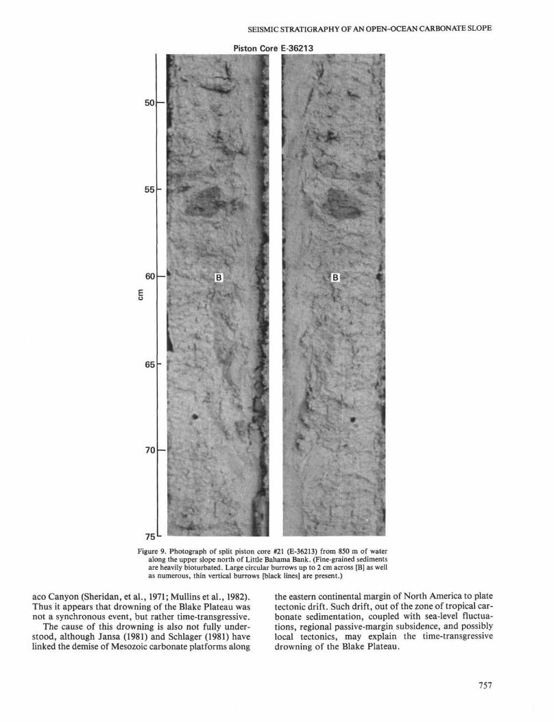
and pronounced downdip downlap (Fig. 8). We interpretthis seismic facies to consist primarily of fine-grainedperiplatform oozes—an interpretation supported by coresamples that have recovered such sediment (Fig. 9). Incontrast, the lower slope is characterized by chaotic todiscontinuous reflections, which we interpret as proxi-mal to distal sediment gravity flow deposits. Cores tak-en from the lower slope support this interpretation, in
753
49,300
49,200-
49,100-
49,000 -
48,900 -
48,800-
48,700
' WEST
Magnetic profile(total intensity)
(gammas)
PROFILE
49,300
- 49,200
—49,100
- 49,000
- 48,900
-48,800
48,700
750
1 8 7 5 -
Tru neat ionNLBB-1
V = 1.92 km/s
10 km
NLBB-2V = 2.4 km/s
R Λ \ rf^ 'N LBB% "^ ̂ :
s ^ S «-- ̂ ^ ^ = jV =3.03 km/s
NLBB-4= 4.56 km/s
I _L
—1.5 2
2.0 o
Figure 5. Total intensity magnetic, air-gun reflection profile and line drawing interpretation of profile E. (Arrows on the magnetic profile mark limits of faulting as seen on the reflection pro-file. For location, see Fig. 2. Vertical exaggeration is approximately 22 ×. Vp = compressional wave velocity.

SEISMIC STRATIGRAPHY OF AN OPEN-OCEAN CARBONATE SLOPE
Oligocene
Eocene
Paleocene
Maestrictian
Campanian
SantonianConiacian
Turonian
Cenomanian
. Presentday
•20
-30
-40
-50
-60
-70
-80
-90
NLBB-1
NLBB-2
NLBB-3
NLBB-4
BP-1
BP-2
BP-3
BP-4
Figure 6. Schematic correlation chart showing inferred ages of NLBB depositional sequences and theirpossible correlation to the Vail et al. (1977) sea-level curve as well as to the depositional sequences(BP-4 to BP-1) of Shipley et al. (1978) from northern Blake Plateau. (Wavy lines represent unconfor-mities; solid lines conformity; dashed line, uncertain boundary.)
Profile 7
1125
I•a
1500-
.. « = ; ~ . - - * . - .
~. . .
.. .. :
Slide
3 km
Figure 7. Photograph of lower slope portion of air-gun profile 7 with sequence boundaries highlighted.(Note contorted, discordant reflectors at the base of NLBB-2, which we interpret as a large slide block.For location of profile, see Fig. 2. Vertical exaggeration is approximately 22 ×.)
755

H. M. VAN BUREN, H. T. MULLINS
Profile 12
525 -0.7
H 750
925-
3 km
Figure 8. Photograph of upper slope portion of air-gun profile 12 with sequence boundaries highlighted. (Notedownlap [D] of slope front fill facies of NLBB-1 onto sequence NLBB-2 as well as truncated reflectors [T] at thetop of NLBB-2. Also present is a contemporary slide scar, indicating that submarine sliding continues to be animportant process along the upper slope through the Recent. For location of profile, see Fig. 2. Vertical exag-geration is approximately 22 × . Mj = multiple reflection.)
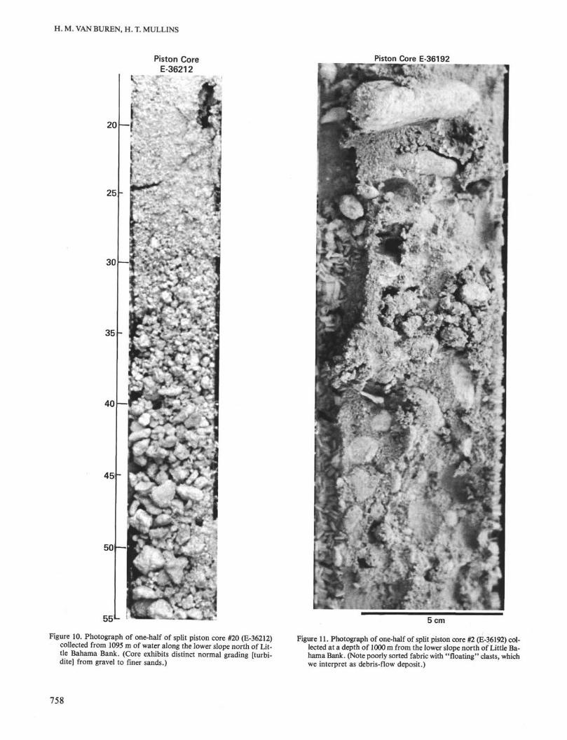
that they have revealed the presence of very coarse-grained carbonate turbidites and debris-flow deposits(Figs. 10, 11).
GEOLOGIC DEVELOPMENT
Based on our seismic stratigraphic interpretations, itis apparent that the geologic development of the carbon-ate slope north of LBB has been complex (Table 1). Ourdata reveal abrupt seismic facies changes that occurboth vertically and laterally.
Depositional sequences NLBB-4 and NLBB-3 are bothsimilar in that they display seismic facies typical of shal-low-water carbonate platform interior sediments in thewestern portion of the study area and seismic faciesmore typical of slope or basinal sedimentation to theeast (Fig. 5). On this basis, we suggest that a carbonateslope existed prior to deposition of the top of NLBB-4(Santonian) along the northeastern margin of LBB, butthat similar deep-water conditions did not exist alongthe northwestern margin of LBB until after depositionof NLBB-3 (end of the Cretaceous).
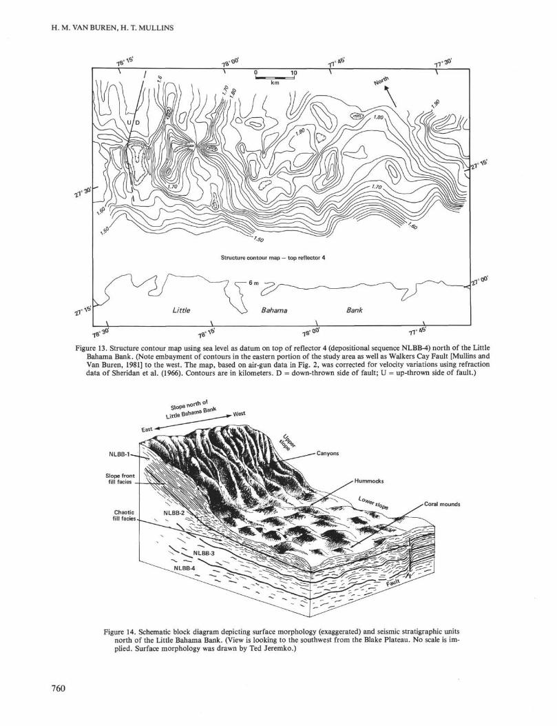
Such a lateral change in deposition north of LBBprobably reflects the presence of the Great Abaco Can-yon, which is pre-Santonian (Ewing et al., 1966; Mullinset al., 1982). Structure contour maps (Figs. 12, 13) onthe top of NLBB-4 (reflector 4) clearly illustrate evi-dence for a structural depression northeast of LBB inthe present vicinity of the Great Abaco Canyon. These
data, in conjunction with our reflection data, suggestthat the Great Abaco Canyon area was a significantstructural depression prior to the Santonian, but hassubsequently been partially infilled, as the present-daycanyon is much more areally restricted (Fig. 12). Suchan interpretation is further supported by the fact thatthis area has the largest negative Bouger gravity anom-aly (-70 mgal) in all of the Bahamas (Talwani, 1960),suggesting the presence of thick, anomalously low-den-sity material.
As the margin north of LBB marks the present bound-ary between the Blake Plateau and Bahamas (Fig. 1),the slope there could not have developed until the BlakePlateau had completely drowned. The exact timing ofthe demise of the "shallow-water" Blake Plateau, how-ever, is not fully known. DSDP data from the BlakeNose indicate that this portion of the Blake Plateaudrowned during the Early Cretaceous (Barremian; Ben-son, Sheridan, et al., 1978). Yet most of the centralBlake Plateau remained a shallow-water environmentuntil near the end of the Albian (Dillon, Paull, Dahl, etal., 1979; Sheridan, et al., 1981) or the end of the Santo-nian (Sheridan and Enos, 1979). Furthermore, our seis-mic stratigraphy suggests that the southernmost BlakePlateau was not drowned until near the end of the Cre-taceous (top of NLBB-3), which is supported by the re-covery of Late Cretaceous shallow-water limestones asyoung as Campanian-Maestrichtian from the Great Ab-
756
SEISMIC STRATIGRAPHY OF AN OPEN-OCEAN CARBONATE SLOPE
Piston Core E-36213
50
55
60
65
70
75 L
Figure 9. Photograph of split piston core #21 (E-36213) from 850 m of wateralong the upper slope north of Little Bahama Bank. (Fine-grained sedimentsare heavily bioturbated. Large circular burrows up to 2 cm across [B] as wellas numerous, thin vertical burrows [black lines] are present.)
aco Canyon (Sheridan, et al., 1971; Mullins et al., 1982).Thus it appears that drowning of the Blake Plateau wasnot a synchronous event, but rather time-transgressive.
The cause of this drowning is also not fully under-stood, although Jansa (1981) and Schlager (1981) havelinked the demise of Mesozoic carbonate platforms along
the eastern continental margin of North America to platetectonic drift. Such drift, out of the zone of tropical car-bonate sedimentation, coupled with sea-level fluctua-tions, regional passive-margin subsidence, and possiblylocal tectonics, may explain the time-transgressivedrowning of the Blake Plateau.
757
H. M. VAN BUREN, H. T. MULLINS
Piston CoreE-36212
Piston Core E-36192
50 —
V,
- -*
55*-
Figure 10. Photograph of one-half of split piston core #20 (E-36212)collected from 1095 m of water along the lower slope north of Lit-tle Bahama Bank. (Core exhibits distinct normal grading [turbi-dite] from gravel to finer sands.)
5 cm
Figure 11. Photograph of one-half of split piston core #2 (E-36192) col-lected at a depth of 1000 m from the lower slope north of Little Ba-hama Bank. (Note poorly sorted fabric with "floating" clasts, whichwe interpret as debris-flow deposit.)
758

SEISMIC STRATIGRAPHY OF AN OPEN-OCEAN CARBONATE SLOPE
Table 1. Summary of seismic stratigraphy and geologic development of the northern margin of LBB.
Seismic sequences
Correlativesequence ofShipley etal. (1978)
NorthernLBB
Assumedvelocity(km/s)a Age
Time(m.y.) Major events
NLBB-4
NLBB-3
BP-4 4.56 Pre-Campanian 98-80
BP-2
NLBB-1
3.03
2.40
1.92
Campanian-Maestrichtian
Paleocene-lateOligocene
late Oligocene-Recent
65-30
30-0
LBB and Blake Plateau formed one continuous shallow-watercarbonate platform, with the exception of the GreatAbaco Canyon area, which was a topographic depressionprior to the Santonian
A shallow-water carbonate platform persisted along thenorthwestern margin of LBB, whereas a slope environmentextended from northeastern LBB into headward regionsof the Great Abaco Canyon; drowning of carbonate plat-form at end of the Cretaceous due to plate tectonic drift,sea-level changes, regional subsidence, and local tectonics.
Deep carbonate bank margin developed along northwesternLBB after drowning of a shallow-water carbonate plat-form; periplatform oozes accumulated along upper slope,and carbonate sediment gravity flows along lower slope;extensive slope instability and submarine sliding; majorerosional event - 30 Ma
Entire margin built up and out after a submarine erosionalevent caused by intensified oceanic circulation in the lateOligocene; periplatform oozes accumulated on upperslope, and slide blocks, turbidites and debris flow depositson lower slope; slope instability and generation of carbon-ate sediment gravity flows continued; recurrent faultingalong Walker's Cay Fault
a Based on Sheridan et al. (1966).
26° >-
78= 76°
Figure 12. Structure contour map, using sea level as datum on top ofreflector 4 (top NLBB-4) for Blake Plateau. (Note large embaymentof contours along northeastern margin of the Little Bahama Bankin the vicinity of the Great Abaco Canyon. Contours are in meters.From Ewing et al. (1966), with permission of American Associationof Petroleum Geologists Bulletin and J. Ewing.)
Once the Blake Plateau had completely drowned, acarbonate slope was able to develop along the entirenorthern margin of LBB. This transition from shallow-water to deeper-water carbonate sedimentation north ofLBB is defined by the downlap of chaotic, discontinu-ous reflectors of sequence NLBB-2 onto the top of even,parallel, continuous reflectors of sequence NLBB-3 (Fig.4). Our reflection data suggest that slope developmenthere was more or less a continuous process, with theaccumulation of periplatform oozes along the upperslope, and submarine slide as well as carbonate sedimentgravity flow deposits along the lower slope. Such depo-sitional patterns were initiated in the early Tertiary andcontinue through the present (Mullins, Van Buren, etal., 1981; Van Buren and Mullins, 1981), as the entireslope has built both up and out.
Slope sedimentation north of LBB was interruptedonly once, during the late Oligocene, by submarine ero-sion. Truncated reflectors at the top of sequence NLBB-2 and distinct downlap of the overlying unit (Fig. 8) de-fine a major unconformity. Submarine erosion at thistime may have been initiated by an oceanic cooling eventand major sea-level fall (Fig. 6). If this erosion occurredduring the late Oligocene, it may be correlative with the"Au" unconformity in the western North Atlantic, whichis a major submarine erosional surface (Paull and Dil-lon, 1980; Tucholke, 1981). A block diagram summariz-ing our results is presented as Figure 14.
Our evidence for extensive submarine sliding and gen-eration of carbonate sediment gravity flows north ofLBB throughout the Cenozoic lends support to the sug-gestions of Benson, Sheridan, et al. (1978) that thisslope may have been a source area for thick, Miocenegravity flow deposits drilled in the Blake-Bahama Basin(also, see Bleifnick and Roberts, this volume). Benson,Sheridan, et al. (1978) have previously proposed that
759
H. M. VAN BUREN, H. T. MULLINS
Structure contour map — top reflector 4
Figure 13. Structure contour map using sea level as datum on top of reflector 4 (depositional sequence NLBB-4) north of the LittleBahama Bank. (Note embayment of contours in the eastern portion of the study area as well as Walkers Cay Fault [Mullins andVan Buren, 1981] to the west. The map, based on air-gun data in Fig. 2, was corrected for velocity variations using refractiondata of Sheridan et al. (1966). Contours are in kilometers. D = down-thrown side of fault; U = up-thrown side of fault.)
NLBB-1
Coral mounds
Figure 14. Schematic block diagram depicting surface morphology (exaggerated) and seismic stratigraphic unitsnorth of the Little Bahama Bank. (View is looking to the southwest from the Blake Plateau. No scale is im-plied. Surface morphology was drawn by Ted Jeremko.)
760

SEISMIC STRATIGRAPHY OF AN OPEN-OCEAN CARBONATE SLOPE
submarine slides along the southern Blake Plateau/northern Bahamas were funnelled into the Great AbacoCanyon and/or the Northeast Providence Channel andultimately deposited in the Blake-Bahama Basin (Fig.1). According to Benson, Sheridan, et al. (1978), sedi-mentation occurred during periods of high sea level,coupled with regional/local tectonic "shaking."
CONCLUSIONSGeologic development of the carbonate slope north
of LBB has been complex. A structural depression ex-isted northeast of LBB prior to the Santonian in thepresent vicinity of the Great Abaco Canyon. This de-pression was probably lined with carbonate slopes andpartially infilled by sediment shed into it. The presentslope north of LBB did not develop until after the com-plete drowning of the southern Blake Plateau near theend of the Cretaceous. Drowning of the plateau may berelated to plate tectonic drift, coupled with regional sub-sidence, sea-level oscillations, and local tectonics.
The slope north of LBB has accreted laterally as a by-pass margin beginning in the early Tertiary and contin-ues to do so today. Periplatform oozes accumulatedalong the upper slope as a slope front fill facies, whereassubmarine slide and carbonate sediment gravity flow de-posits accumulated along the lower slope in the form ofa base-of-slope apron that strikes parallel to the adja-cent shelf edge. However, during the late Oligocene, thisslope became an eroded margin as a result of submarineerosion, possibly correlative with the "Au" unconform-ity in the western North Atlantic. Overall, we concludethat lateral accretion, sediment bypassing, and subma-rine erosion have interacted during regional passive mar-gin subsidence, sea-level fluctuations, and local tecton-ics to produce a single, open-ocean carbonate slope.
ACKNOWLEDGMENTS
Ship time aboard Duke University's Eastward was provided aspart of a National Science Foundation grant to A. C. Neumann andA. C. Hine at the University of North Carolina. We thank W. P. Dil-lon, A. C. Hine, and S. D. Locker for their reviews of this manu-script. We also thank R. E. Sheridan and F. M. Gradstein for helpfulcomments and for inviting us to contribute to this volume.
REFERENCES
Benson, W. E., Sheridan, R. E., et al., 1978. Init. Repts. DSDP, 44:Washington (U.S. Govt. Printing Office).
Crevello, P. D., and Schlager, W., 1980. Carbonate debris sheets andturbidites, Exuma Sound, Bahamas. J. Sediment. Petrol., 50:1121-1148.
Dillon, W. P., Paull, C. K., Buffler, R. T., and Fail, J. P., 1979. Struc-ture and development of the southeast Georgia embayment andnorthern Blake Plateau: preliminary analysis. Am. Assoc. Pet.Geol. Mem., 29:27-41.
Dillon, W. P., Paull, C. K., Dahl, A. G., and Patterson, W. C , 1979.Structure of the continental margin near the COST No. GE-1 drillsite from a CDP seismic reflection profile. U.S. Geol. Surv. Circ,800:97-108.
Ewing, J., Ewing, M., and Leyden, R., 1966. Seismic profiler surveyof Blake Plateau. Am. Assoc. Pet. Geol. Bull, 50:1948-1971.
Hine, A. C , and Neumann, A. C , 1977. Shallow carbonate bankmargin growth and structure, Little Bahama Bank, Bahamas. Am.Assoc. Pet. Geol. Bull., 61(3):376-406.
Hine, A. C , Wilber, R. J., Bane, J. M., Neumann, A. C , and Loren-son, K. A., 1981. Offbank transport of carbonate sands along
open, leeward bank margins, northern Bahamas. Mar. Geol., 42:327-348.
Jansa, L. F., 1981. Mesozoic carbonate platforms and banks of theeastern North American margin. Mar. Geol., 44:97-118.
JOIDES, 1965. Ocean drilling on the continental margin. Science,150:709-716.
King, P. B., 1969. Tectonic map of North America: Washington(U.S. Geol. Surv. G67154).
Lighty, R. G., 1981. Fleshy-algal domination of a modern Bahamianbarrier reef: example of an alternate climax reef community.Fourth Int. Symp. Coral Reefs, Manila, Phillippines, p. 37.
Locker, S. D., 1980. Origin and depositional history of a semi-en-closed windward lagoon off Great Abaco Island, Bahamas [M.S.thesis]. University of North Carolina, Chapel Hill.
Lynts, G. W., Judd, J. B., and Stehman, C. F., 1973. Late Pleistocenehistory of Tongue of the Ocean, Bahamas. Geol. Soc. Am. Bull.,84:2665-2684.
Mitchum, R. M., Vail, P. R., and Sangree, J. B., 1977. Stratigraphicinterpretation of seismic reflection patterns in depositional se-quences. Am. Assoc. Pet. Geol. Mem., 26:117-134.
Mitchum, R. M., Vail, P. R. and Thompson, S., 1977. Depositionalsequence as a basic unit for stratigraphic analysis. Am. Assoc. Pet.Geol. Mem., 26:53-62.
Mullins, H. T., Keller, G. H., Kofoed, J. W., Lambert, D. N., Stub-blefield, W. L., and Warme, J. E., 1982. Geology of Great AbacoSubmarine Canyon: observations from the research submersibleAlvin. Mar. Geol., 48:239-257.
Mullins, H. T., and Neumann, A. C , 1979. Deep carbonate bankmargin structure and sedimentation in the northern Bahamas. Soc.Econ. Paleontol. Mineral. Spec. Pub!., 27:165-192.
Mullins, H. T., Neumann, A. C , Wilber, R. J., and Boardman, M.R., 1980a. Nodular carbonate sediment on Bahamian slopes: pos-sible precursors to nodular limestones. /. Sediment. Petrol., 50(1):117-131.
Mullins, H. T., Neumann, A. C , Wilber, R. J., Hine, A. C , andChinburg, S. J., 1980b. Carbonate sediment drifts in northernStraits of Florida, ,4/M. ASSOC. Pet. Geol. Bull., 64(10):1701-1717.
Mullins, H. T., Newton, C. R., Heath, K., and Van Buren, H. M.,1981. Modern deep-water coral mounds north of Little BahamaBank: criteria for the recognition of deep-water coral bioherms inthe rock record. /. Sediment. Petrol., 51:999-1013.
Mullins, H. T., and Van Buren, H. M., 1981. Walkers Cay Fault, Ba-hamas: evidence for Cenozoic faulting. Geo. Mar. Lett., 1:225-231.
Mullins, H. T., Van Buren, H. M., Davis, R. A., Heath, K., andNewton, C. R., 1981. Anatomy of a modern open-ocean wind-ward carbonate slope: northern Little Bahama Bank. Am. Assoc.Pet. Geol. Bull., 65:962-963. (Abstract)
Paull, C. K., and Dillon, W. P., 1980. Erosional origin of the BlakeEscarpment: an alternative hypothesis. Geology, 8:538-542.
Payton, C. E. (Ed.), 1977. Seismic stratigraphy—applications to hy-drocarbon exploration. Am. Assoc. Pet. Geol. Mem., 26:516.
Sangree, J. B., and Widmier, J. M., 1977. Seismic interpretation ofclastic depositional facies. Am. Assoc. Pet. Geol. Mem., 26:165-184.
Schlager, W., 1981. The paradox of drowned reefs and carbonate plat-forms. Geol. Soc. Am. Bull., 92:197-211.
Schlager, W., and Chermak, A., 1979. Sediment facies of platform-basin transition, Tongue of the Ocean, Bahamas. Soc. Econ. Pale-ontol. Mineral. Spec. Publ., 27:193-208.
Schlager, W., and Ginsburg, R. N., 1981. Bahama carbonate plat-forms-the deep and the past. Mar. Geol., 44:1-24.
Sheridan, R. E., 1981. Geophysical recognition and structure of car-bonate platforms and platform edges on passive continental mar-gins. Mar. Geol., 44:171-180.
Sheridan, R. E., Berman, R. M., and Corman, D. B., 1971. Faultedlimestone block dredged from Blake Escarpment. Geol. Soc. Am.Bull., 82:199-206.
Sheridan, R. E., Crosby, J. T., Bryan, G. M., and Stoffa, P. L., 1981.Stratigraphy and structure of southern Blake Plateau, northernFlorida Straits and northern Bahama Platform from multichan-nel seismic reflection data. Am. Assoc. Pet. Geol. Bull., 65(12):2571-2593.
Sheridan, R. E., Drake, C. L., Nafe, J. E., and Hennion, J., 1966.Seismic refraction study of continental margin east of Florida.Am. Assoc. Pet. Geol. Bull., 50:1972-1990.
761

H. M. VAN BUREN, H. T. MULLINS
Sheridan, R. E., and Enos, P., 1979. Stratigraphic evolution of theBlake Plateau after a decade of scientific drilling. Am. Geophys.Union, Maurice Ewing Series, 3:109-122.
Sheridan, R. E., and Osburn, W. L., 1975. Marine geologic and geo-physical studies of the Florida-Blake Plateau-Bahamas area. Can.Soc. Pet. Geol. Mem., 9:9-32.
Shipley, T. H., Buffler, R. T., and Watkins, J. S., 1978. Seismic stra-tigraphy and geologic history of Blake Plateau and adjacent west-ern Atlantic continental margin. Am. Assoc. Pet. Geol. Bull, 62:792-812.
Talwani, M., 1960. Gravity anomalies in the Bahamas and their inter-pretation [Ph.D. dissert.]. Columbia University, New York.
Tucholke, B. E., 1981. Geologic significance of seismic reflectors inthe deep western North Atlantic basin. Soc. Econ. Paleontol.Mineral. Spec. Publ., 32:23-37.
Vail, P. R., Mitchum, R. M., and Thompson, S., 1977. Global cyclesof relative changes of sea level. Am. Assoc. Pet. Geol. Mem.,26:83-98.
Van Buren, H. M., and Mullins, H. T., 1981. Seismic stratigraphy ofa modern carbonate slope. Am. Assoc. Pet. Geol. Bull., 65:1004.
Date of Initial Receipt: March 29, 1982
762