Embed Size (px)
Citation preview

BookletChart™ Cape May Harbor NOAA Chart 12317
A reduced-scale NOAA nautical chart for small boaters When possible, use the full-size NOAA chart for navigation.
2
Published by the National Oceanic and Atmospheric Administration
National Ocean Service Office of Coast Survey
www.NauticalCharts.NOAA.gov 888-990-NOAA
What are Nautical Charts?
Nautical charts are a fundamental tool of marine navigation. They show water depths, obstructions, buoys, other aids to navigation, and much more. The information is shown in a way that promotes safe and efficient navigation. Chart carriage is mandatory on the commercial ships that carry America’s commerce. They are also used on every Navy and Coast Guard ship, fishing and passenger vessels, and are widely carried by recreational boaters.
What is a BookletChart?
This BookletChart is made to help recreational boaters locate themselves on the water. It has been reduced in scale for convenience, but otherwise contains all the information of the full-scale nautical chart. The bar scales have also been reduced, and are accurate when used to measure distances in this BookletChart. See the Note at the bottom of page 5 for the reduction in scale applied to this chart.
Whenever possible, use the official, full scale NOAA nautical chart for navigation. Nautical chart sales agents are listed on the Internet at http://www.NauticalCharts.NOAA.gov.
This BookletChart does NOT fulfill chart carriage requirements for regulated commercial vessels under Titles 33 and 44 of the Code of Federal Regulations.
Notice to Mariners Correction Status
This BookletChart has been updated for chart corrections published in the U.S. Coast Guard Local Notice to Mariners, the National Geospatial Intelligence Agency Weekly Notice to Mariners, and, where applicable, the Canadian Coast Guard Notice to Mariners. Additional chart corrections have been made by NOAA in advance of their publication in a Notice to Mariners. The last Notices to Mariners applied to this chart are listed in the Note at the bottom of page 7. Coast Pilot excerpts are not being corrected.
For latest Coast Pilot excerpt visit the Office of Coast Survey website at http://www.nauticalcharts.noaa.gov/nsd/searchbychart.php?chart=12317
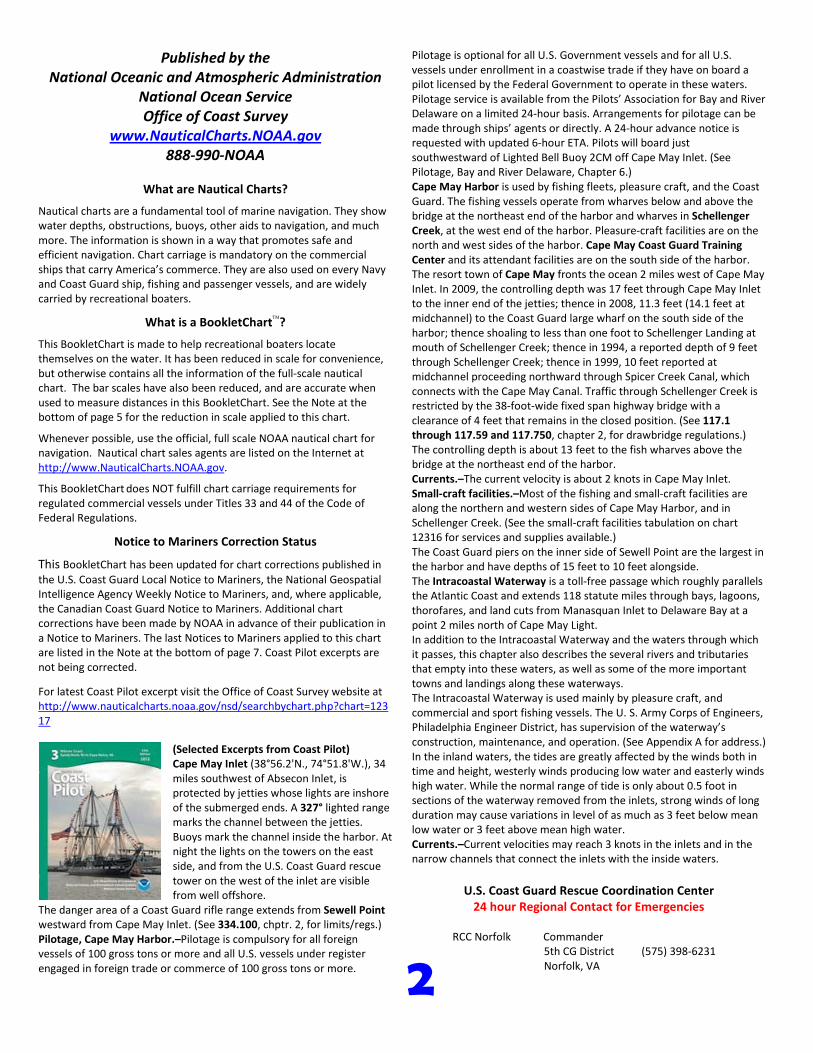
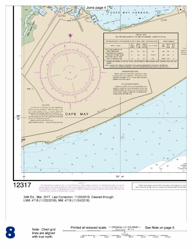
(Selected Excerpts from Coast Pilot) Cape May Inlet (38°56.2'N., 74°51.8'W.), 34 miles southwest of Absecon Inlet, is protected by jetties whose lights are inshore of the submerged ends. A 327° lighted range marks the channel between the jetties. Buoys mark the channel inside the harbor. At night the lights on the towers on the east side, and from the U.S. Coast Guard rescue tower on the west of the inlet are visible from well offshore.
The danger area of a Coast Guard rifle range extends from Sewell Point westward from Cape May Inlet. (See 334.100, chptr. 2, for limits/regs.) Pilotage, Cape May Harbor.–Pilotage is compulsory for all foreign vessels of 100 gross tons or more and all U.S. vessels under register engaged in foreign trade or commerce of 100 gross tons or more.
Pilotage is optional for all U.S. Government vessels and for all U.S. vessels under enrollment in a coastwise trade if they have on board a pilot licensed by the Federal Government to operate in these waters. Pilotage service is available from the Pilots’ Association for Bay and River Delaware on a limited 24-hour basis. Arrangements for pilotage can be made through ships’ agents or directly. A 24-hour advance notice is requested with updated 6-hour ETA. Pilots will board just southwestward of Lighted Bell Buoy 2CM off Cape May Inlet. (See Pilotage, Bay and River Delaware, Chapter 6.) Cape May Harbor is used by fishing fleets, pleasure craft, and the Coast Guard. The fishing vessels operate from wharves below and above the bridge at the northeast end of the harbor and wharves in Schellenger Creek, at the west end of the harbor. Pleasure-craft facilities are on the north and west sides of the harbor. Cape May Coast Guard Training Center and its attendant facilities are on the south side of the harbor. The resort town of Cape May fronts the ocean 2 miles west of Cape May Inlet. In 2009, the controlling depth was 17 feet through Cape May Inlet to the inner end of the jetties; thence in 2008, 11.3 feet (14.1 feet at midchannel) to the Coast Guard large wharf on the south side of the harbor; thence shoaling to less than one foot to Schellenger Landing at mouth of Schellenger Creek; thence in 1994, a reported depth of 9 feet through Schellenger Creek; thence in 1999, 10 feet reported at midchannel proceeding northward through Spicer Creek Canal, which connects with the Cape May Canal. Traffic through Schellenger Creek is restricted by the 38-foot-wide fixed span highway bridge with a clearance of 4 feet that remains in the closed position. (See 117.1 through 117.59 and 117.750, chapter 2, for drawbridge regulations.) The controlling depth is about 13 feet to the fish wharves above the bridge at the northeast end of the harbor. Currents.–The current velocity is about 2 knots in Cape May Inlet. Small-craft facilities.–Most of the fishing and small-craft facilities are along the northern and western sides of Cape May Harbor, and in Schellenger Creek. (See the small-craft facilities tabulation on chart 12316 for services and supplies available.) The Coast Guard piers on the inner side of Sewell Point are the largest in the harbor and have depths of 15 feet to 10 feet alongside. The Intracoastal Waterway is a toll-free passage which roughly parallels the Atlantic Coast and extends 118 statute miles through bays, lagoons, thorofares, and land cuts from Manasquan Inlet to Delaware Bay at a point 2 miles north of Cape May Light. In addition to the Intracoastal Waterway and the waters through which it passes, this chapter also describes the several rivers and tributaries that empty into these waters, as well as some of the more important towns and landings along these waterways. The Intracoastal Waterway is used mainly by pleasure craft, and commercial and sport fishing vessels. The U. S. Army Corps of Engineers, Philadelphia Engineer District, has supervision of the waterway’s construction, maintenance, and operation. (See Appendix A for address.) In the inland waters, the tides are greatly affected by the winds both in time and height, westerly winds producing low water and easterly winds high water. While the normal range of tide is only about 0.5 foot in sections of the waterway removed from the inlets, strong winds of long duration may cause variations in level of as much as 3 feet below mean low water or 3 feet above mean high water. Currents.–Current velocities may reach 3 knots in the inlets and in the narrow channels that connect the inlets with the inside waters.
U.S. Coast Guard Rescue Coordination Center 24 hour Regional Contact for Emergencies
RCC Norfolk Commander
5th CG District (575) 398-6231 Norfolk, VA

G
NOAA’s navigation managers serve as ambassadors to the maritime community. They help identify navigational challenges facing professional and recreational mariners, and provide NOAA resources and information for safe navigation. For additional information, please visit nauticalcharts.noaa.gov/service/navmanagers
To make suggestions or ask questions online, go to nauticalcharts.noaa.gov/inquiry. To report a chart discrepancy, please use ocsdata.ncd.noaa.gov/idrs/discrepancy.aspx.
Lateral System As Seen Entering From Seaward on navigable waters except Western Rivers
PORT SIDE
ODD NUMBERED AIDS
GREEN LIGHT ONLY
FLASHING (2)
PREFERRED CHANNEL
NO NUMBERS – MAY BE LETTERED
PREFERRED CHANNEL TO
STARBOARD
TOPMOST BAND GREEN
PREFERRED CHANNEL
NO NUMBERS – MAY BE LETTERED
PREFERRED CHANNEL
TO PORT
TOPMOST BAND RED
STARBOARD SIDE
EVEN NUMBERED AIDS
RED LIGHT ONLY
FLASHING (2)
FLASHING FLASHING
OCCULTING GREEN LIGHT ONLY RED LIGHT ONLY OCCULTING QUICK FLASHING QUICK FLASHING
ISO COMPOSITE GROUP FLASHING (2+1) COMPOSITE GROUP FLASHING (2+1) ISO
"1"
Fl G 6s
G "9"
Fl G 4s
GR "A"
Fl (2+1) G 6s
RG "B"
Fl (2+1) R 6s
"2"
Fl R 6s
8
R "8"
Fl R 4s
LIGHT
G
C "1"
LIGHTED BUOY
G
"5"
GR
"U"
GR
C "S"
RG
N "C"
RG
"G"
LIGHT
6
R
N "6"
LIGHTED BUOY
R
"2
"
CAN DAYBEACON
CAN NUN NUN
DAYBEACON
For more information on aids to navigation, including those on Western Rivers, please consult the latest USCG Light List for your area.
These volumes are available online at http://www.navcen.uscg.gov
Navigation Managers Area of Responsibility
Northeast
Lt. Meghan McGovern
Northwest and
Pacific Islands
Crescent Moegling
Great Lakes Region
Tom Loeper
Chesapeake and
Delaware Bay
Steve Soherr
California
Jeff Ferguson
[email protected] Mid-Atlantic
Lt. Ryan Wartick
Alaska
Lt. Timothy M. Smith
Western Gulf Coast
Alan Bunn
Central Gulf Coast
Tim Osborn
[email protected] South Florida
Puerto Rico
U.S. Virgin Islands
Michael Henderson
Southeast
Kyle Ward
2
2 C U 5
1


VHF Marine Radio channels for use on the waterways:Channel 6 – Inter-ship safety communications.Channel 9 – Communications between boats and ship-to-coast.Channel 13 – Navigation purposes at bridges, locks, and harbors.Channel 16 – Emergency, distress and safety calls to Coast Guard and others, and to initiate calls to other
vessels. Contact the other vessel, agree to another channel, and then switch.Channel 22A – Calls between the Coast Guard and the public. Severe weather warnings, hazards to navigation and safety warnings are broadcast here.Channels 68, 69, 71, 72 and 78A – Recreational boat channels.
Getting and Giving Help — Signal other boaters using visual distress signals (flares, orange flag, lights, arm signals); whistles; horns; and on your VHF radio. You are required by law to help boaters in trouble. Respond to distress signals, but do not endanger yourself.
EMERGENCY INFORMATION
Distress Call Procedures
• Make sure radio is on.• Select Channel 16.• Press/Hold the transmit button.• Clearly say: “MAYDAY, MAYDAY, MAYDAY.”• Also give: Vessel Name and/or Description;Position and/or Location; Nature of Emergency; Number of People on Board.• Release transmit button.• Wait for 10 seconds — If no responseRepeat MAYDAY call.
HAVE ALL PERSONS PUT ON LIFE JACKETS!
This Booklet chart has been designed for duplex printing (printed on front and back of one sheet). If a duplex option is not available on your printer, you may print each sheet and arrange them back-to-back to allow for the proper layout when viewing.
QR
Quick ReferencesNautical chart related products and information - http://www.nauticalcharts.noaa.gov
Interactive chart catalog - http://www.charts.noaa.gov/InteractiveCatalog/nrnc.shtmlReport a chart discrepancy - http://ocsdata.ncd.noaa.gov/idrs/discrepancy.aspx
Chart and chart related inquiries and comments - http://ocsdata.ncd.noaa.gov/idrs/inquiry.aspx?frompage=ContactUs
Chart updates (LNM and NM corrections) - http://www.nauticalcharts.noaa.gov/mcd/updates/LNM_NM.html
Coast Pilot online - http://www.nauticalcharts.noaa.gov/nsd/cpdownload.htm
Tides and Currents - http://tidesandcurrents.noaa.gov
Marine Forecasts - http://www.nws.noaa.gov/om/marine/home.htm
National Data Buoy Center - http://www.ndbc.noaa.gov/
NowCoast web portal for coastal conditions - http://www.nowcoast.noaa.gov/
National Weather Service - http://www.weather.gov/
National Hurrican Center - http://www.nhc.noaa.gov/
Pacific Tsunami Warning Center - http://ptwc.weather.gov/
Contact Us - http://www.nauticalcharts.noaa.gov/staff/contact.htm
NOAA’s Office of Coast Survey The Nation’s Chartmaker
For the latest news from Coast Survey, follow @NOAAcharts
NOAA Weather Radio All Hazards (NWR) is a nationwide network of radio stations broadcasting continuous weather information directly from the nearest National Weather Service office. NWR broadcasts official Weather Service warnings, watches, forecasts and other hazard information 24 hours a day, 7 days a week. http://www.nws.noaa.gov/nwr/