Embed Size (px)
Citation preview
Capability and limitsof Remote Sensing in GAEC detection: the
Health Check challenge
Maurizio Piomponi – AGEAPaolo Tosi, Sandrina Paolini, Livio Rossi –SIN

Remote Sensing (RS) and Cross‐Compliance assumption in Italy
•Cross‐Compliance controls, particularly for GAEC, started in 2005 by RS
•Differently vs. eligibility task, all the detected negative and doubtful GAEC parcels are always double – checked in situ

Summary
• Overview of AGEA 2009 test activity
• Main results
• New tables of results comparison
• New tasks for new requirements(2010‐2012)

2009 test purpose:
AGEA test under the supervision of JRC, for validating the Use of multi‐spectral and multi‐temporal
remote sensing for GAEC Controls (AGEA own investment)
Target:Detection capability of GAECs issues by RS, in
comparison with traditional ground survey (through two separated activities);
costs, time and benefits

examples of VHR RS GAEC detection: Grosseto
Lack of correct drainage
Landslides on crops
Rill erosion
Landslides and creeping

….loss of soil and agricultural surface is an irreversible issue:
a GAEC problem towards an eligibility one…..
2009, July

….growing loss of soil on arable land (standard 1.1)‐ Agrigento test aerea
2007
2009
Evident increasing of linear (rill/gully) and landslide phenomena

The Test requested by DGAgri, the methodology discussed and agreed with JRC in sharing with DGAgri
task flow:
1. Test areas identification on 2009 sample zones in Italy
2. Satellite data selection (VHR or HR)
3. Ancillary data, specifications and mobile PCs preparation
4. Ground surveys performance, as “ground truth”
5. Photo‐interpretation of VHR and HR data,
6. Joint results evaluation, cost/benefits analysis, operational considerations

GAEC targets to be investigated
• Standard 1.1 soil erosion: protect soil on slope
• Standard 2.1 soil organic matter: maintain soil organic levels (ban on burning residues)
• Standard 3.1 soil structure: maintenance of water drainage
• Standard 4.1 permanent pasture: correct management and ban on converting
• Standard 4.3 olive groves: maintenance levels
• Standard 4.4 terraces maintenance
Additional requirement by the Commission: 4.1 analysis on vegetation encroachment on pastures, even if not applied in Italy

GAEC Cods used both by Ground Survey and Photo interpretation

Test areas identification
Among 45 sample areas (municipality groups, average 500 skm each) with the following criteria:
• GAEC infringements presence, detected during last 3 years of controls (also neighbouring)
• Risk value, by AGEA GAEC risk map of Italy, updated in 2009
• Declared crops presence and agro‐morphologic different patterns

Selected test sitesstarting from 2009
AGEA RS sample
Following the criteria the final 5 test areas were:
Pesaro-Urbino (Marche – North-centre)Grosseto (Tuscany – Centre)Messina (Sicily – South)Agrigento (Sicily – South)Siracusa (Sicily – South)

Ground survey task flow:
1. Curricula selection among AGEA expert inspectors (two technicians per area)
2. Specific and ad hoc SW and data uploading on mobile PCs
3. Experts training per area (by 2 expert tutors)
4. Ground survey for GAEC controls, using GPS traceability; “blind” repetition by the second surveyor
5. Activity control and management via WEB
6. Test completion and results sent via WEB (reference parcels definition and eventual breach’s pictures)

Transects with selected points (related parcels) to be investigated both in situ and by RS
Parcels concentration on orthophotos by the archive:different approach by traditional sample controls

Data for Ground survey at work
-Maps printing, perProvince area
-Transect maps, with reference parcels (two transects per area)
-Survey sheets and cod table
-Uploaded PCs Ultramobile, operational SW and GPS
-Car recharge cablesfor PCs

WEB site for ground survey management data collection and verification

Satellite photo‐interpretation task flow:
1. Curricula selection among AGEA experts in Agriculture RS (proven skill)
2. Training for 3 selected technicians on common objectives (by 1 tutor)
3. Interpretation of each reference parcel using the same cods of ground survey
4. “Blind” repetition, on each transect, by the other two experts
5. Sample quality control by the tutor
6. Results evaluation (int. variance) and comparison

results/statistic per test site
Yellow = declared impossible surveys in situ

GAEC infringements foundper Test area (1)
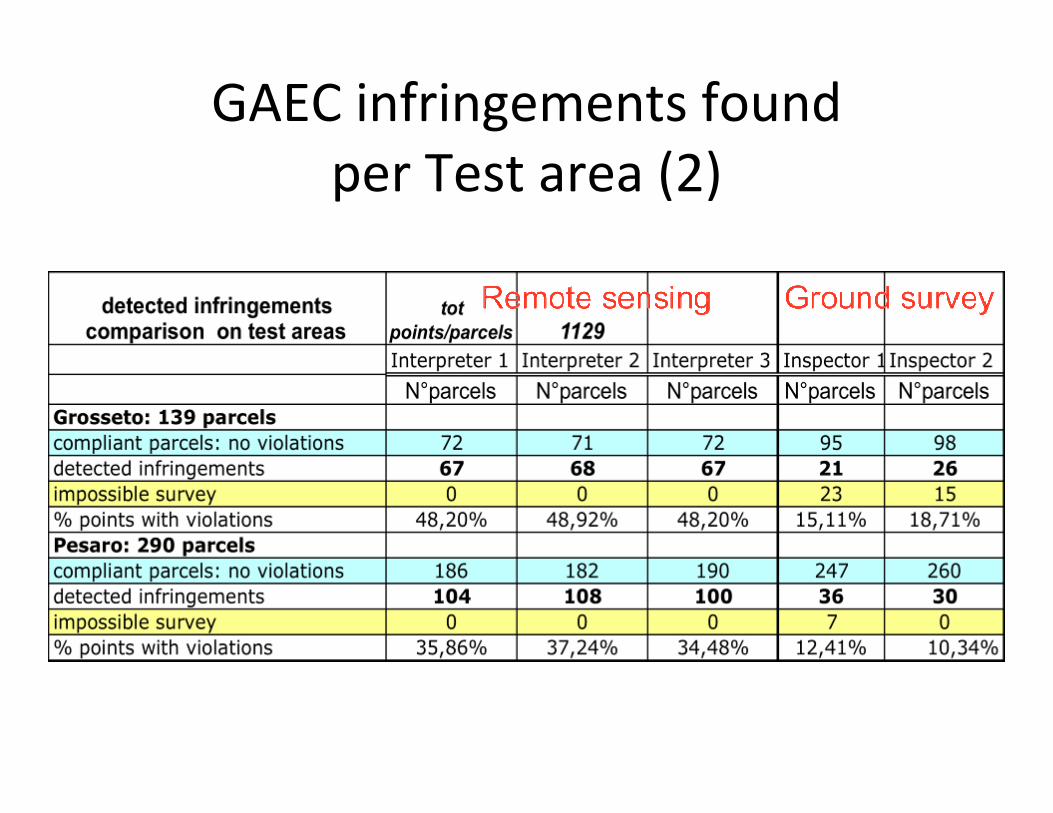
GAEC infringements found per Test area (2)

Photo‐interpretation intrinsic variance

Messina‐ evaluationof pasture
managementan additional test
2009, July
2009, April
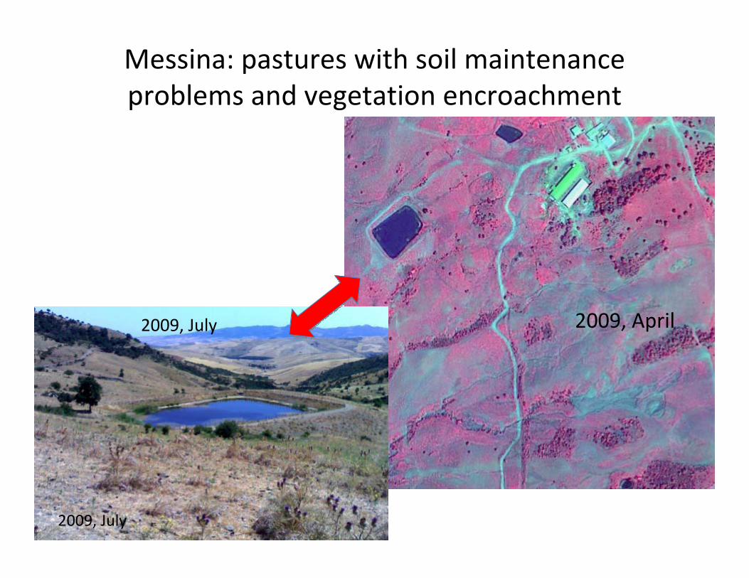
Messina: pastures with soil maintenance problems and vegetation encroachment
2009, April
2009, July
2009, July

Results of additional test: vegetation encroachment on pastures (Messina)
High consistency, mature…

Pastures Messina:unique point of non accordance
90: permanent Encroachmentinterpreted by sat not validated by ground
89: permanent EncroachmentInterpreted by sat and validated by ground
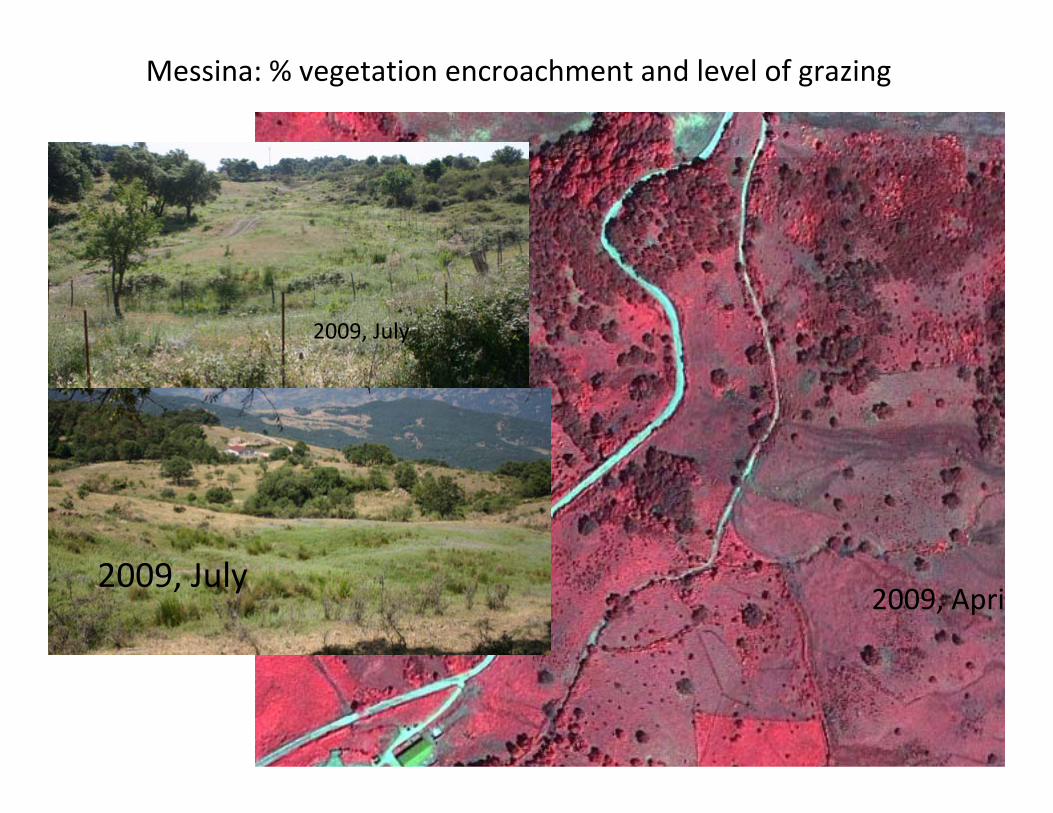
Messina: % vegetation encroachment and level of grazing
2009, July
2009, July2009, Apri

% of encroachment, only detected by RSmultiple aspects, complex morphology, lack of
synoptic view created difficulty by ground survey

Spot 4, 20 m planned for end of August 2009 photo‐interpretation of burnt stubbles –standard 2.1
Selected points to be interpreted and double checked on ground
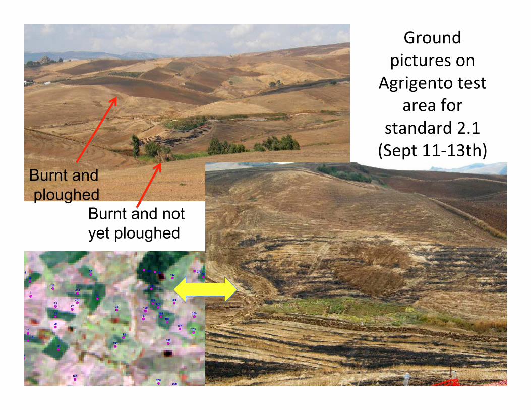
Ground pictures on
Agrigento test area for
standard 2.1 (Sept 11‐13th)
Burnt andploughed
Burnt and not yet ploughed

Burnt stubbles detection: standard 2.1main outputs
High consistency, mature…
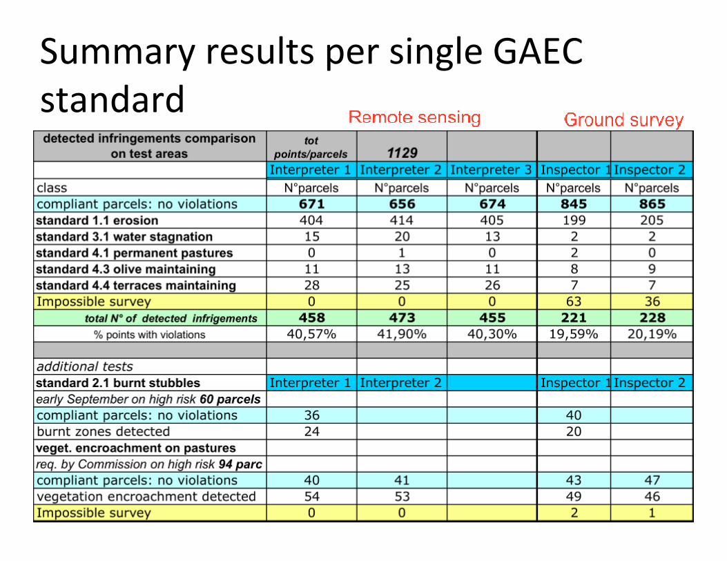
Summary results per single GAEC standard
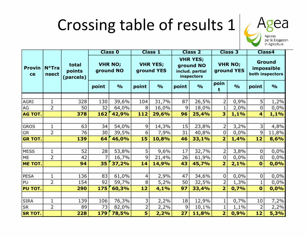
Crossing table of results 1

Crossing table: final results
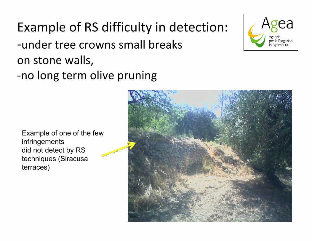
Example of RS difficulty in detection: ‐under tree crowns small breaks on stone walls, ‐no long term olive pruning
Example of one of the few infringements did not detect by RS techniques (Siracusaterraces)

Statistics on impossible ground surveys
Total number of “impossible visits”, summing accordance(2 inspectors) and partial (only one inspector)

Impossible surveys post‐analysis
Main reasons of not checked parcels in situ
• 4x4 car usage….?
• Initiative, agility (jump the fence/barbed wires…)?
• Fear of dogs?
• Lack of communication between inspectors (closed gates, no practicable roads, etc.) ?

Working time: cost/benefits after result comparison

Other advantages of RS
• Test points/parcels were close in small Transects, while in operation parcels are scattered on 500 skmareas (ref. in situ working time)
• Interpretation gave responses on several additional points/parcels vs ground surveys (non calculated on tables)
• Aerial ortho‐imagery used for LPIS updating can be also used to identify some of the major GAEC issues, improving national/local risk analysis

Examples‐Agrigento: landslip/erosion ground truth
2009, July
2009, April

Grosseto: lack of drainage damages and rill after overgrazing
Diffused rill erosion, provoked by overgrazing-No ditches/belt presence:detectable by RS
Detectable and measurable Damages on parcel

Exam. Grosseto: abandoned olives, rill erosion
Abandoned olives

Agrigento: slight creeping effects vs. satellite detection
2009, July
2009, April
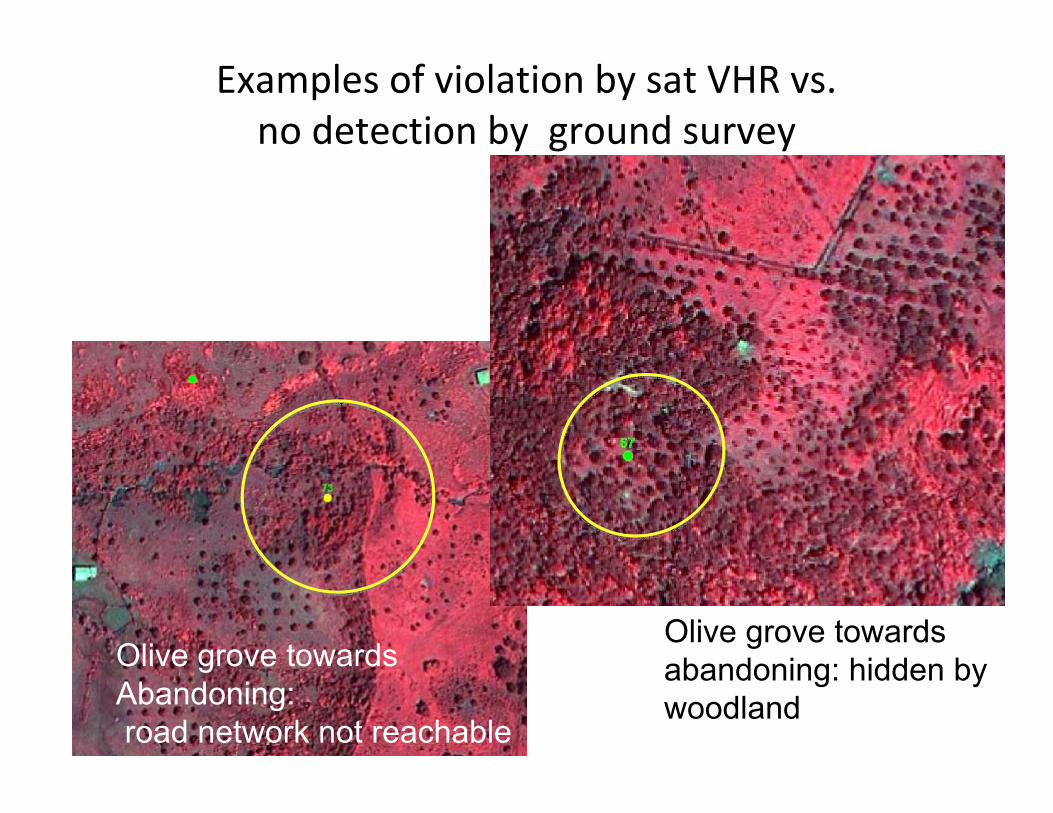
Examples of violation by sat VHR vs. no detection by ground survey
Olive grove towards Abandoning: road network not reachable
Olive grove towards abandoning: hidden by woodland

Examples VHR YES; ground NO – Grossetochecked again in situ, guided by RS evidence‐ late Sept
Sept 09Deeper linear erosion, still visible in September

Increasing of phenomenadetected in post verification
Sept 09
Sept 09
April 09
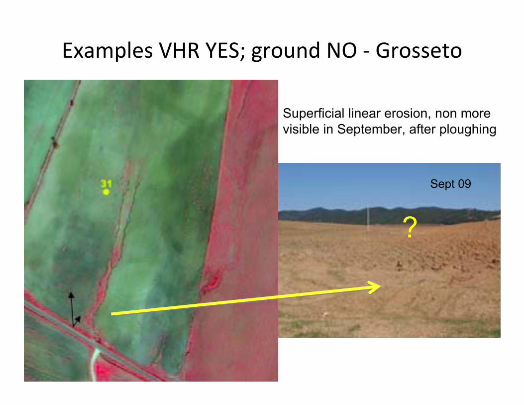
Examples VHR YES; ground NO ‐ Grosseto
Sept 09
Superficial linear erosion, non more visible in September, after ploughing
?

Grosseto: stable sludge without protection danger for water course…NIR sat differences in detection

1‐ Comments on standard 1.1soil erosion
• VHR Satellite: complete and assured detection
• In Situ: complete detection when parcels are visited
Remote sensing always detected
more parcels vs ground (mean + 100%)
No parcel found in violation on
ground was left by Sat
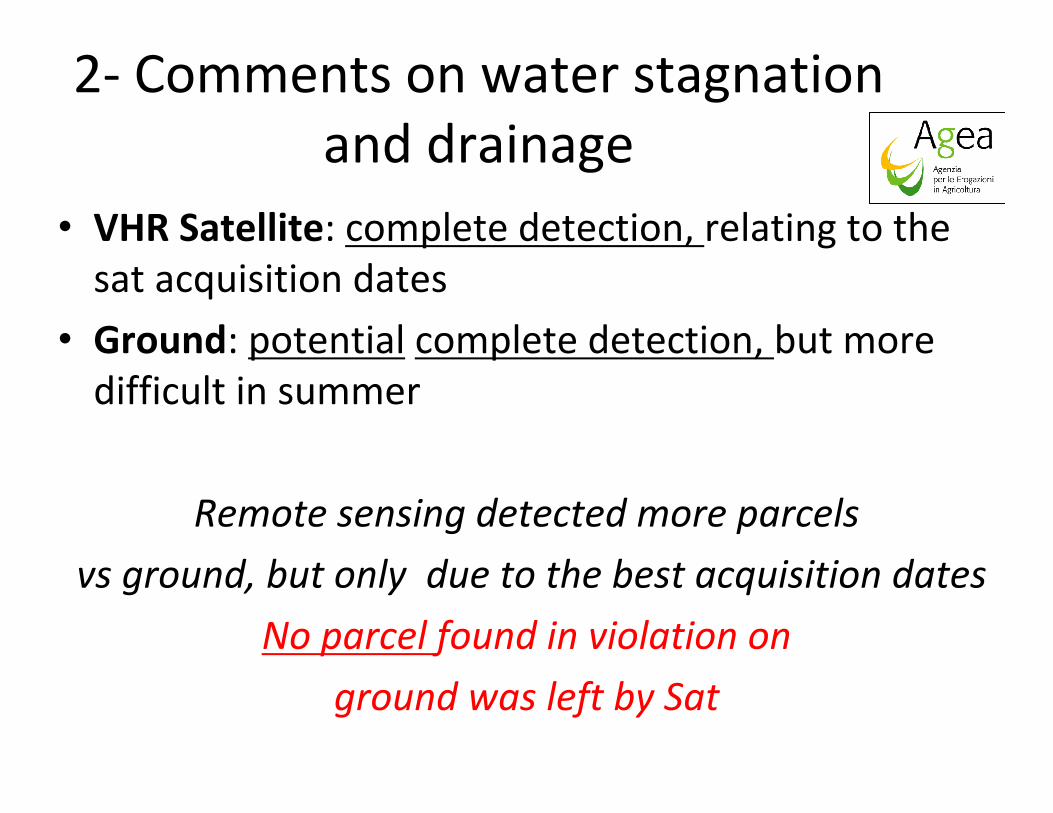
2‐ Comments on water stagnation and drainage
• VHR Satellite: complete detection, relating to the sat acquisition dates
• Ground: potential complete detection, but more difficult in summer
Remote sensing detected more parcels
vs ground, but only due to the best acquisition dates
No parcel found in violation on
ground was left by Sat

3‐ Comments on olive groves maintenance
• VHR Satellite: complete detection for permanent vegetation (bush, wood) Difficult pruned/not pruned det., without a reference;
• Ground: potential complete detection when parcels are visited (LFA = difficult access)
•Remote sensing detected more parcels (mean + 20%);
difficult in breach’s type identification
6 parcels found in violation on
ground (lack of pruning) were left by Sat

4‐ Comments on permanent pastures maintenance/encroachment
• VHR Satellite: good detection of pasture maintenance; complete detection of vegetation encroachment, including %
• Ground: potential complete detection when parcels are visited; % of encroachment on site more difficult
Remote sensing detected more veg. encroachments with % per parcel (mean + 8%)
2 parcels found in violation on
ground (permanent crop presence) were left by Sat

5‐ Comments on terraces maintaining
• VHR Satellite: complete detection, but impossible for hidden phenomena (under tree crowns, shadows)
• Ground: potential complete detection when parcels are visited; several impossible surveys
Remote sensing detected more than
double infringements (13% vs 5,5%)
3 parcels found in violation on
ground (under trees) were left by Sat

5‐ Comments on burnt stubbles detection
• HR Satellite: complete and sometimes redundant detection, due to local soil conditions (wet/ploughed)
• Ground: complete detection, but difficult when fields have already been ploughed
Remote sensing generally indicates
a redundant number of violations (24/20)
No parcel found in violation on
ground was left by Sat

Synthetic table of results

2010 test purpose:
1. Confirmation of the 2009 results
2. Verify the possibility to check new issues with the same devices and procedure
3. Test new sensors and method of control
4. Improve the whole control system

Health Check challenge: main issues
• Landscape features identification, improving GAEC risk analysis and controls, testing different sensors (optical , SAR) and methods, aiming at LPIS improving
• Winter crops coverage for GAEC risk analysis and controls, trying to use high resolution SAR, due to its all weather capability
• Water courses buffer protection (from 2012, annex III‐ 73/09) using DSM at different resolutions, RS and several ancillary information and layers for mapping, risk priority and buffer size definition

GAECs new organisation for 2010Annex III Reg. (EC)
73/2009New Standard organisation
Issue GAEC 2010 Application Requirement
1‐ SOIL EROSION
Standard 1.1: Minimum land management reflecting site specific conditions
all agricultural landTemporary channelling of surface water on sloping terrain
Standard 1.2: Minimum land cover
requirement a): arable land
a) for the agricultural land which is no longer used for production purposes: vegetal cover, natural or sown, during the whole year
requirement b): all agricultural land
b) for all surfaces with the presence of a risk for erosion: vegetal cover, natural or sown, during the winter period
Standard 1.3: Retain terraces all agricultural land
a) to eliminate terraces is forbiddenb) every levelling intervention of the agricultural land has to be authorized by the competent bodies
2. SOIL ORGANIC MATTER
Standard 2.1: Stubble management
arable land no longer used
stubble burning is forbidden
Standard 2.2: Crop rotation arable land
cereals can't be cultivated for a period of more than 5 years without interruption with other cultivations
3. SOIL STRUCTUREStandard 3.1: Appropriate machinery use
all agricultural landa. machinery use only with the correct soil condition (umidity) so to not compromise the soil structure

Landscape features and winter grass coverage detection through VHR SAR 1m res.
Creeping
Hedgerow/trees network
arable
sowing directions
pasture

Water drainage problems evidences lead to a ground survey to verify the correct machine
use
GAEC 2010 – 2Annex III Reg. (EC) 73/2009
New Standard organisation
Issue GAEC 2010 Application Requirement
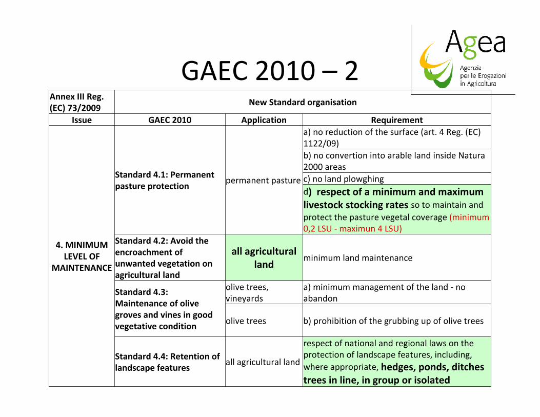
4. MINIMUM LEVEL OF
MAINTENANCE
Standard 4.1: Permanent pasture protection
permanent pasture
a) no reduction of the surface (art. 4 Reg. (EC) 1122/09)b) no convertion into arable land inside Natura 2000 areasc) no land plowghingd) respect of a minimum and maximum livestock stocking rates so to maintain and protect the pasture vegetal coverage (minimum 0,2 LSU ‐ maximun 4 LSU)
Standard 4.2: Avoid the encroachment of unwanted vegetation on agricultural land
all agricultural land
minimum land maintenance
Standard 4.3: Maintenance of olive groves and vines in good vegetative condition
olive trees, vineyards
a) minimum management of the land ‐ no abandon
olive trees b) prohibition of the grubbing up of olive trees
Standard 4.4: Retention of landscape features
all agricultural land
respect of national and regional laws on the protection of landscape features, including, where appropriate, hedges, ponds, ditches trees in line, in group or isolated

Vegetation encroachment on crops, starting from LPIS
arable > pasture > transitional (...>abandon?)

Indicators: scattered and hedge‐trees
62

Terraces presence and conditions
63
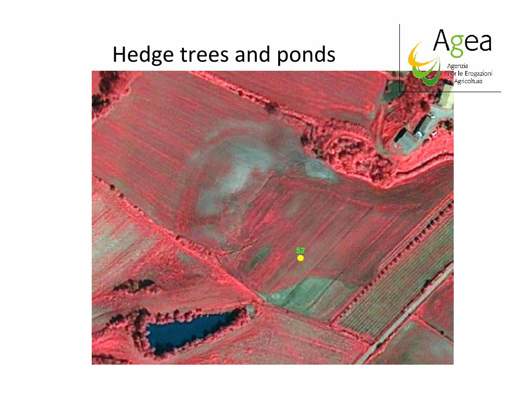
Hedge trees and ponds
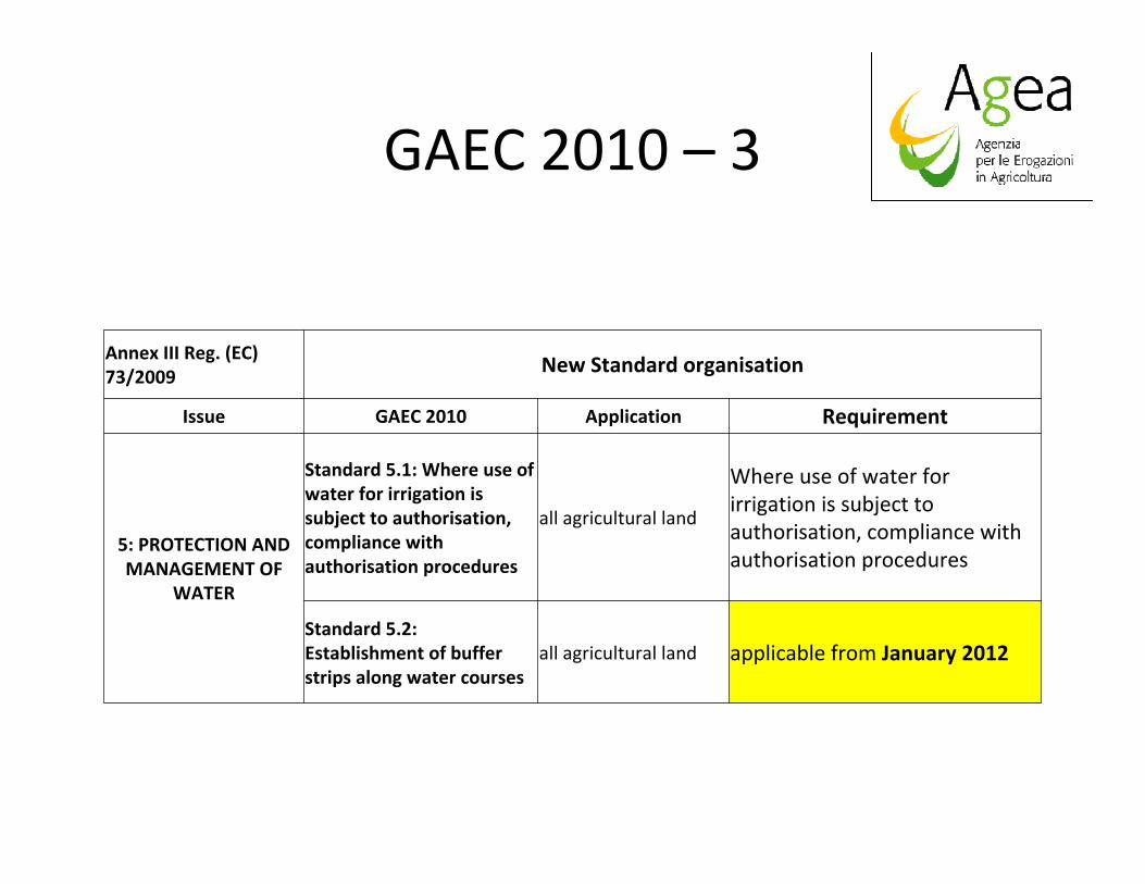
GAEC 2010 – 3
Annex III Reg. (EC) 73/2009 New Standard organisation
Issue GAEC 2010 Application Requirement
5: PROTECTION AND MANAGEMENT OF
WATER
Standard 5.1: Where use of water for irrigation is subject to authorisation, compliance with authorisation procedures
all agricultural land
Where use of water for irrigation is subject to authorisation, compliance with authorisation procedures
Standard 5.2: Establishment of buffer strips along water courses
all agricultural land applicable from January 2012

Satellite SAR data for winter coverage
monitoring5 m res. 40 km strip
swath