Embed Size (px)
Citation preview
State Water Resources Control Board
Cannabis Cultivation Policy
Staff Report
October 17, 2017

DRAFT Cannabis Cultivation Policy-Staff Report – October 17, 2017 Page 1
Table of Contents Acronyms and Abbreviations ............................................................................................... 4
INTRODUCTION ....................................................................................................................... 6
Legislative / Regulatory Background .................................................................................. 6
OVERVIEW OF POLICY REGIONS .......................................................................................... 7
Climate ..................................................................................................................................10
Precipitation .........................................................................................................................13
Hydrology .............................................................................................................................15
Geology ................................................................................................................................20
Salmonid Species ................................................................................................................22
Water Quality Impairment – Clean Water Act Section 303(d) List .....................................25
Overview of Cannabis Cultivation Impacts ........................................................................27
BACKGROUND AND RATIONALE FOR POLICY REQUIREMENTS FOR WATER DIVERSION AND WASTE DISCHARGES ASSOCIATED WITH CANNABIS CULTIVATION .29
Cleanup, Restoration, and Mitigation ......................................................................30
Constituents of Concern ..........................................................................................30
Cultural Resource Protection ..................................................................................32
Fertilizers, Pesticides, Petroleum Products and Other Chemicals .......................32
General Water Quality Certification .........................................................................34
Irrigation Runoff .......................................................................................................36
Land Disturbance and Erosion Control ..................................................................36
Onsite Wastewater Treatment Systems ..................................................................37
Refuse, Domestic Waste, and Cannabis Cultivation Waste ..................................37
Riparian and Wetland Protection and Management ...............................................38
Road Construction and Maintenance ......................................................................42
Slope and Erosion Potential Relationship ..............................................................43
Soil Disposal and Storage........................................................................................44
Winterization .............................................................................................................44
Water Diversion, Storage, and Use .....................................................................................45
Bypass ......................................................................................................................45
Fish Screens and Diversion Structures ..................................................................45
Groundwater Diversions, Wells, and Exempt Springs ...........................................45
Measuring and Reporting Water Diversions ...........................................................46
Off-stream Storage Reservoirs ................................................................................46
Onstream Reservoirs ...............................................................................................46
Rain Water Catchment .............................................................................................46
Springs ......................................................................................................................47
DRAFT Cannabis Cultivation Policy-Staff Report – October 17, 2017 Page 2
Storage Bladders ......................................................................................................47
BACKGROUND AND RATIONALE FOR INSTREAM FLOW AND GAGING REQUIREMENTS .................................................................................................................................................48
Wet Season Diversion Period: As early as November 1 to March 31 ..............................48
Diversion Rate ......................................................................................................................50
50% Visual Bypass Requirement ........................................................................................50
Methodology for Development of Numeric Instream Flow Requirements .......................51
Tennant Methodology ..............................................................................................51
Tessmann Methodology – A Common Modification of the Tennant Method .......52
Flow Model for Estimating Natural Monthly Streamflows in California ................54
Applying the Tessmann Methodology to USGS Monthly Flow Data ................................58
Aquatic Base Flows .............................................................................................................58
Methodology for Development of Dry Season Aquatic Base Flow Values ...........59
RATIONALE AND METHODOLOGY FOR COMPLIANCE GAGE ASSIGNMENTS ................60
Identifying Appropriate Compliance Gages .......................................................................60
Identifying Ungaged Watershed Boundaries .....................................................................62
Paired Watershed Gage Approach – General Pairing Procedure .....................................62
Gage Assignment Maps .......................................................................................................64
WATER QUALITY ANTIDEGRADATION ANALYSIS ..............................................................79
REFERENCES .........................................................................................................................82
List of Tables Table 1. Summary of Nine Hydrologic Classes
Table 2. Listed and Special-Status Anadromous Salmonids by Policy Region Table 3. Water Quality Contaminants and Percent Impairment in the Nine Policy Priority
Regions Table 4. Instream Flow Regimens for Fish, Wildlife, Recreation, and Related
Environmental Resources Table 5. Tessmann Method Flow Requirements Table 6. Number of Reference Gages used in USGS Model and Cannabis Policy
Compliance Gages by Region Table 7. Percent Accuracy of Model Predictions Relative to the Historical Gage Record
of Select Gages in each Region Table 8. Gage Assessment Summary
List of Figures Figure 1. Cannabis Cultivation Policy Regional Boundaries Figure 2. Köppen Climate Classification Figure 3. Average Annual Precipitation (1981- 2010) Figure 4. Hydrologic Classification Figure 5. California Geologic Survey-Geomorphic Provinces Figure 6. Tessmann Method Flow Requirements Criteria
DRAFT Cannabis Cultivation Policy-Staff Report – October 17, 2017 Page 3
Figure 7. Klamath Region – Compliance Gage Figure 8. Upper Sacramento Region – Compliance Gage Figure 9. North Coast Region – Compliance Gage
Figure 10. Middle Sacramento Region – Compliance Gage Figure 11. South Sacramento Region – Compliance Gage Figure 12. North Central Coast Region – Compliance Gage Figure 13. South Central Coast Region – Compliance Gage Figure 14. San Joaquin Region – Compliance Gage Figure 15. South Coast Region – Compliance Gage Figure 16. North East Desert Region – Compliance Gage Figure 17. Tahoe Region – Compliance Gage Figure 18. Mono Region – Compliance Gage Figure 19. Kern Region – Compliance Gage Figure 20. South East Desert Region – Compliance Gage
Appendices Appendix 1: Regional Descriptions Appendix 2: Salmonid Life Histories and Threats to Viability

DRAFT Cannabis Cultivation Policy-Staff Report – October 17, 2017 Page 4
Acronyms and Abbreviations
ACL Administrative Civil Liability Antidegradation Policy State Water Board Resolution 68-16, the Statement of Policy
with Respect to Maintaining High Quality of Waters in California
Army Corps United States Army Corps of Engineers AUMA Adult Use of Marijuana Act of 2016 Basin Plan Water Quality Control Plan BOF Board of Forestry BPTC Best Practicable Treatment or Control BPC California Business and Professions Code CAL FIRE California Department of Forestry and Fire Protection CAO Cleanup and Abatement Orders CDFA California Department of Food and Agriculture Cannabis Policy Cannabis Cultivation Policy, Principles and Guidelines for
Cannabis Cultivation CIWQS California Integrated Water Quality System CUA Compassionate Use Act of 1996 CEQA California Environmental Quality Act CDEC California Data Exchange Center CDFA California Department of Food and Agriculture CDFW California Department of Fish and Wildlife CDO Cease and Desist Order cfs CHRIS
Cubic feet per second California Historical Resources Information System
CWA Clean Water Act Deputy Director Deputy Director for the Division of Water Rights DPR Department of Pesticides Regulation DPS Distinct Population Segments DTE Distinct Taxonomic Entities DWR California Department of Water Resources e.g. Latin exempli gratia (for example) ESA Federal Endangered Species Act ESU Evolutionary Significant Unit Executive Officer Executive Officer of the Regional Water Quality Control Board FER Flashy, Ephemeral Rain hydrologic regime FPR Forest Practice Rules General Order General Waste Discharge Requirements for Discharges of
Waste associated with Cannabis Cultivation Activity GW Groundwater hydrologic regime HELP High Elevation and Low Precipitation hydrologic regime HSR High-Volume Snowmelt and Rain hydrologic regime HUC Hydrologic Unit Code HSC Health and Safety Code ILRP Irrigated Lands Regulatory Program LSA Agreement Lake and Streambed Alteration Agreement LSR Low-Volume Snowmelt and Rain hydrologic regime LTO Licensed Timber Operator MCRSA Medical Cannabis Regulation and Safety Act

DRAFT Cannabis Cultivation Policy-Staff Report – October 17, 2017 Page 5
MMRSA Medical Marijuana Regulation and Safety Act NCRO Department of Water Resources, North Central Region Office NHD National Hydrography Database NHDPlusV2 National Hydrography Database Plus Version 2 NMP Nitrogen Management Plan NOA Notice of Applicability NONA Notice of Non-Applicability NOT Notice of Termination NOV Notice of Violation NPDES National Pollutant Discharge Elimination System NPS Nonpoint Source Pollution Control Program NRO Department of Water Resources, North Region Office NTU Nephelometric Turbidity Units NWIS O/E OWTS
National Water Information System Observed over expected Onsite Wastewater Treatment System
PGR Perennial Groundwater and Rain hydrologic regime RSG Rain and Seasonal Groundwater hydrologic regime Regional Water Board Regional Water Quality Control Board Road Handbook Handbook for Forest, Ranch, and Rural Roads RPF California Registered Professional Forester RWD Report of Waste Discharge State Water Board State Water Resources Control Board SB Senate Bill SCCWRP Southern California Coastal Water Research Project SCR Site Closure Report SIC Standard Industrial Code SDR Small Domestic Registrations SEPs Supplemental Environmental Projects SIUR Small Irrigation Use Registrations SM Snowmelt hydrologic regime SW-CGP Storm Water Construction General Permit SW-IGP Storm Water Industrial General Permit SWPPP Storm Water Pollution Prevention Plan THP Timber Harvest Plan TMDL Total Maximum Daily Load TNC UC Davis
The Nature Conservancy University of California, Davis
US United States USBR United States Bureau of Reclamation USEPA United States Environmental Protection Agency USGS United States Geological Survey Water Boards State Water Board and Regional Water Boards WDRs WLPZ
Waste Discharge Requirements Watercourse and Lake Protection Zone
DRAFT Cannabis Cultivation Policy-Staff Report – October 17, 2017 Page 6
INTRODUCTION The purpose of this Cannabis Cultivation Policy Staff Report (Staff Report) is to provide background, rationale and justification for the principles and guidelines contained in the Cannabis Cultivation Policy: Principles and Guidelines for Cannabis Cultivation (Policy). The Policy establishes principles and guidelines (herein “Requirements”) for cannabis cultivation activities to protect water quality and instream flows. The purpose of the Policy is to ensure that the diversion of water and discharge of waste associated with cannabis cultivation does not have a negative impact on water quality, aquatic habitat, riparian habitat, wetlands, and springs. The Policy applies to the following cannabis cultivation activities throughout California:
Commercial Recreational
Commercial Medical
Personal Use Medical The Policy does not apply to recreational cannabis cultivation for personal use, which is limited to six plants under the Adult Use of Marijuana Act (Proposition 64, approved by voters in November 2016)1.
Legislative / Regulatory Background Proposition 215, the Compassionate Use Act (CUA) of 1996 (Health and Safety Code Section 11362.5 et seq.) established the medical cannabis industry. While Proposition 215 laid the groundwork for medical cannabis use, it did not provide a regulatory system for oversight of the cultivation, distribution, or sale of cannabis, nor did it establish any type of control of the environmental impacts from cannabis cultivation within the state. In 2003, Senate Bill (SB) 420 was enacted by the Legislature to clarify the scope of the CUA and provided California cities and counties authority to adopt and enforce cannabis related rules and regulations consistent with SB 420 and the CUA. Without appreciable regulatory oversight however, large-scale cannabis cultivation proliferated in remote areas throughout California. In an effort to provide a regulatory framework for the cannabis industry, Governor Brown signed the Medical Marijuana Regulation and Safety Act (MMRSA)2, which became effective on January 1, 2016. MMRSA created a state licensing system for cultivation, manufacture, sale, distribution, and testing of medical cannabis.
On June 27, 2016, the Governor signed SB 837, which included a number of changes to the MMRSA including replacing the term marijuana with cannabis, changing the name of the MMRSA to the Medical Cannabis Regulation and Safety Act (MCRSA), and adding environmental protection statutes that place certain mandates on the State Water Resources Control Board (State Water Board).
1 Recreational cannabis cultivation for personal use as defined in Health and Safety Code section
11362.1(a)(3) and section 11362.2. 2 The Medical Marijuana Regulation and Safety Act consisted of Assembly Bills 243 and 266, and Senate
Bill 643.

DRAFT Cannabis Cultivation Policy-Staff Report – October 17, 2017 Page 7
In November 2016, voters approved Proposition 64, the Adult Use of Marijuana Act (AUMA), which legalized recreational cannabis cultivation, and the possession and use of limited amounts of cannabis by adults over 21 years of age. AUMA requires the same environmental protections as MCRSA. Among other provisions, the MCRSA and the AUMA require the California Department of Food and Agriculture (CDFA) to issue licenses to commercial cannabis cultivators and establish a track and trace program that tracks commercial cannabis from seed or clone through cultivation, harvest, transport, manufacture, distribution, and sale to the end user.
On June 27, 2017, the Governor signed SB 94 which combines the requirements of MCRSA and AUMA into a unified code. Cannabis cultivation related legislation established:
Water Code section 13149, which authorizes the State Water Board, in consultation with the California Department of Fish and Wildlife (CDFW), to adopt interim and long-term principles and guidelines (requirements) for the diversion and use of water for cannabis cultivation. The requirements:
o shall include measures to protect springs, wetlands, and aquatic habitats from negative impacts of cannabis cultivation; and
o may include requirements that apply to groundwater diversions where the State Water Board determines those requirements are reasonably necessary.
Water Code section 13276, which directs the Regional Water Quality Control Boards (Regional Water Boards) or the State Water Board to address discharges of waste resulting from medical and commercial cannabis cultivation, including adopting a general permit establishing waste discharge requirements, or taking action pursuant to Water Code section 13269.
Business and Professions Code section 26060.1(b) requires that any cannabis cultivation licenses issued by CDFA include conditions requested by the Department of Fish and Wildlife and the State Water Resources Control Board to ensure that individual and cumulative effects of water diversion and discharge associated with cannabis cultivation do not affect the instream flows needed for fish spawning, migration, and rearing, and the flows needed to maintain natural flow variability. The conditions shall include, but not be limited to, the principles, guidelines, and requirements established pursuant to Section 13149 of the Water Code.
OVERVIEW OF POLICY REGIONS California is a large and geographically diverse state, covering 163,696 square miles, and spanning over 800 miles of coastline. California’s multiple mountain ranges and valleys result in highly variable climate, precipitation and drainage patterns.

DRAFT Cannabis Cultivation Policy-Staff Report – October 17, 2017 Page 8
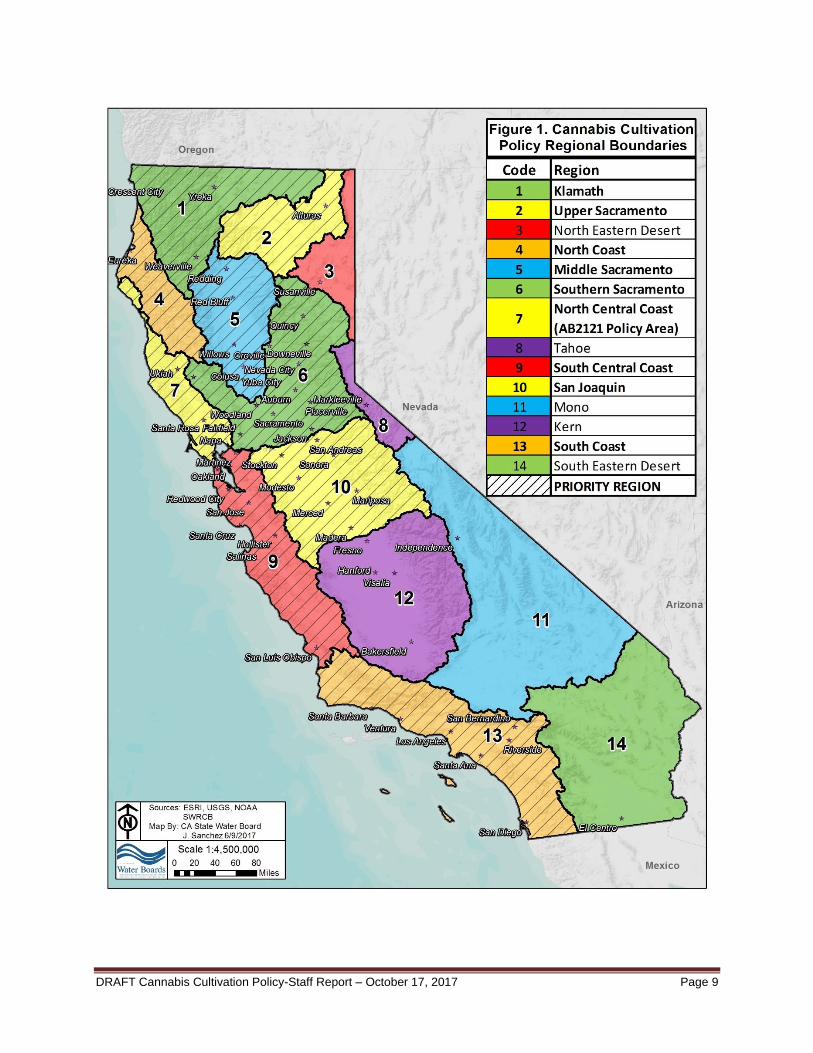
Fourteen regions are identified in the Policy to account for the state’s size and geographic diversity: Klamath, Upper Sacramento, North Eastern Desert, North Coast, Middle Sacramento, Southern Sacramento, North Central Coast, Tahoe, South Central Coast, San Joaquin, Mono, Kern, South Coast, and South Eastern Desert (Figure 1). As mentioned above, the Policy establishes Requirements to protect water quality and instream flows statewide. These Requirements include minimum instream flows that must be met or exceeded at a specific compliance flow gage when water is being diverted for cannabis cultivation. The Policy identifies 14 regions, and identifies nine regions as priority regions that support anadromous salmonids. The priority regions are: Klamath, Upper Sacramento, North Coast, Middle Sacramento, Southern Sacramento, North Central Coast, South Central Coast, San Joaquin, and South Coast.
DRAFT Cannabis Cultivation Policy-Staff Report – October 17, 2017 Page 9

DRAFT Cannabis Cultivation Policy-Staff Report – October 17, 2017 Page 10
This section provides a general overview of the climate, precipitation, hydrology, geology and anadromous salmonid populations throughout the state. More detailed descriptions for each priority region (including discussion of regional elevations, climate, precipitation, hydrologic classifications, monthly average temperatures, and anadromous fish distribution) are located in Appendix 1. It is anticipated that more detailed descriptions for the remaining five regions will be developed and added to the final Staff Report.
Climate California’s diverse topography has a profound impact on regional climates. CDFW modified the Köppen Climate Classification System, a classification system that is used to describe the world’s climates, to describe California climatic conditions on a more localized scale (CDFG3, 2002. CDFW’s modified Köppen Climate Classification System includes 11 climate classifications, which fall within five general categories: Steppe, Desert, Mediterranean, Cool Interior, and Highland. A general overview of the climatic and temperature patterns for each climate category is described below. Figure 2 shows a climatic map of California based on CDFW’s adaptation of the Köppen Climate Classification System. California’s Steppe climates include the following classifications: Semi-arid, steppe (hot); Semi-arid, steppe; and Semi-arid, steppe with summer fog. California’s southern San Joaquin Valley, portions of the Basin and Range and Mojave Desert are characterized by Steppe climates. Similar to the desert climates, Steppe climates are characterized by heat, but these regions tend to receive enough moisture to support vegetation, such as grasslands, that are not typically found in deserts. In these areas, average maximum temperatures are approximately 80 degrees Fahrenheit (°F) and average annual minimum temperatures are approximately 45-50°F. Temperatures are less extreme in the southern San Joaquin valley compared to many locations in the Colorado and Mojave Deserts because there is a slightly more marine influence in the San Joaquin Valley. California’s Desert climates include the following classifications: Arid low latitude desert (hot); and Arid mid latitude desert. Much of the Colorado and Mojave Deserts are characterized by Desert climates. California’s Desert climatic regions are characterized by low annual precipitation, low humidity, high daily temperature fluctuations, and annual temperature extremes. Dry climates (including both Desert and Steppe) are characterized by the actual precipitation generally being below the potential evapotranspiration. In Desert climatic regions, temperature extremes and the range of temperature fluctuation tend to be much greater than those in Mediterranean climates, which is a result of the lower humidity and very little marine influence in Desert areas. In portions of the Mojave and Colorado Deserts, average annual maximum temperatures reach 90°F, and average annual minimum temperatures fall to 45°F.
3 The California Department of Fish and Wildlife was previously named the California Department of Fish
and Game (CDFG).

DRAFT Cannabis Cultivation Policy-Staff Report – October 17, 2017 Page 11
California’s Mediterranean climates include the following classifications: Mediterranean/hot summer; Mediterranean/cool summer, and Mediterranean/summer fog. California’s coastal regions, northern Central Valley, and Sierra Nevada foothills are generally characterized by Mediterranean climates. California’s Mediterranean climatic regions are characterized by warm to hot summers, and cool, wet winters. Weather systems and marine influences in these regions tend to reduce the range of temperature fluctuations and moderate temperature extremes. Areas with stronger marine influences tend to exhibit lower average annual maximum temperatures. Average annual maximum temperatures reach 65-70°F along the California coast, 75°F in the Sierra Nevada foothills and northern Central Valley, and up to 80°F in much of the Central Valley and in portions of the southern California coast. Average annual minimum temperatures in these areas rarely fall below 40°F. California’s Cool Interior climates include the following classifications: Cool continental/dry summer; and Cold winter/dry summer. The Modoc Plateau and upper elevation Sierra Nevada mountains are characterized by Cool Interior climates. California’s Cool Interior climatic regions are characterized by dry summers, cool to cold winters, and significant winter snowfall. In these regions, average annual maximum temperatures tend to remain below 65°F and many areas exhibit average annual maximum temperatures below 55°F. Average annual minimum temperatures in these areas are generally below 40°F, with below freezing temperatures common. California’s Highland climate includes the Highland/Timberline classification: The highest elevation areas of the southern Sierra Nevada Mountains are characterized by Highland/Timberline climates. California’s Highland/Timberline climatic regions are climatically similar to Cool Interior regions. These areas are often drier than the Cool Interior regions in the northern Sierra Nevada Mountains and Cascade Range, but Highland/Timberline climatic areas more commonly receive summer rainfall. Average annual maximum temperatures in many high elevation areas stay below 45°F, with average minimum temperatures remaining below freezing.

DRAFT Cannabis Cultivation Policy-Staff Report – October 17, 2017 Page 12
DRAFT Cannabis Cultivation Policy-Staff Report – October 17, 2017 Page 13
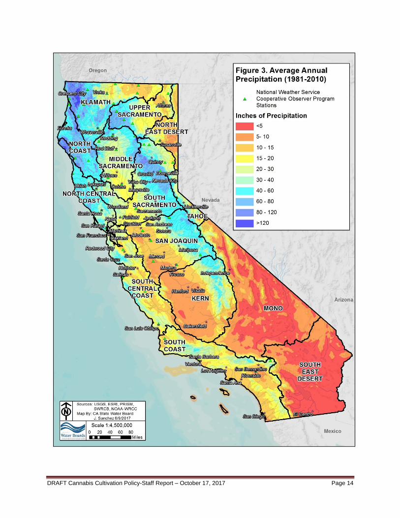
Precipitation Overall, California precipitation patterns are characterized by cool, wet winters and very dry summers. The vast majority of California’s precipitation typically falls between October and May, and half of the annual precipitation tends to fall between December and February. California receives very little precipitation during the summer months; most locations receive less than 10 percent of annual precipitation between June and September. Summer thundershowers occur in the Sierra Nevada Mountains, Klamath Mountains, and Cascade Range, but these weather events contribute little to overall precipitation volumes. Precipitation in California falls as rain and snow. Figure 3. Average Annual Precipitation shows the statewide average annual precipitation amounts based on observations and extrapolated data (PRISM, 2016). As illustrated in Figure 3, precipitation volumes are typically much higher in northern California compared to southern California, and a north-to-south precipitation gradient is readily apparent. Snowfall typically occurs at elevations above 3,000 feet, and significant snowpack can persist at elevations above 5,000 feet. Spring snowmelt pulse flows that typically continue into summer are characteristic of streams in high elevation watersheds. Precipitation patterns in California are influenced by regional topography. Orographic uplift and rain shadow effects impact precipitation and streamflows on the western and eastern side of California’s mountain ranges. California’s precipitation patterns also tend to vary substantially from year to year as the result of ocean circulation patterns, atmospheric moisture, and other factors. Large scale ocean circulation patterns, such as the El Niño/La Niña ocean circulation cycle, exert great influence over California precipitation volumes and patterns. During El Niño, California tends to receive higher amounts of precipitation during winter, especially in southern California. During La Niña, high amounts of winter precipitation may occur in northern California, while southern California often remains cool and dry. Weather phenomena, such as atmospheric rivers, can also greatly effect California’s precipitation patterns. Atmospheric rivers are highly concentrated corridors of atmospheric moisture that bring warm rains in extreme volumes to California. Since these features are very narrow, one region may be heavily impacted by an atmospheric river while another area sees only minimal precipitation.
DRAFT Cannabis Cultivation Policy-Staff Report – October 17, 2017 Page 14
DRAFT Cannabis Cultivation Policy-Staff Report – October 17, 2017 Page 15
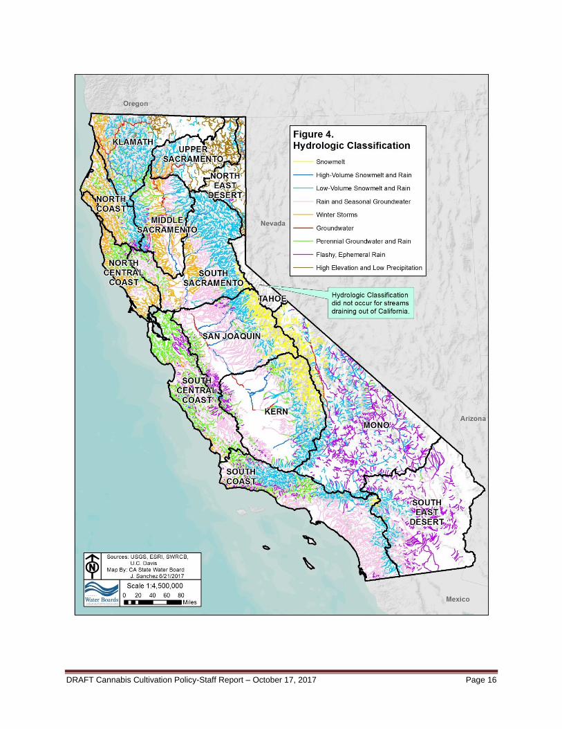
Hydrology In California, stream hydrology is influenced by regional geologic, climatic, and precipitation patterns. To characterize California’s diverse streamflow patterns, a team from the University of California-Davis (UC Davis) in collaboration with the Southern California Coastal Water Research Project (SCCWRP) developed a hydrologic classification system for California. The resultant stream classification was applied to all stream reaches in California attributed to the United States Geological Survey (USGS) National Hydrography Database (NHD) Plus Version 2 (NHDPlusV2), as shown in Figure 4. The hydrologic classification system excludes first-order (headwater) streams and all streams in the Lake Tahoe Basin from its hydrologic analysis. The UC Davis-SCCWRP hydrologic classification system defines nine hydrologic classifications, described as follows: Snowmelt; High-Volume Snowmelt and Rain; Low-Volume Snowmelt and Rain; Rain and Seasonal Groundwater; Winter Storms; Groundwater; Perennial Groundwater and Rain; Flashy, Ephemeral Rain; and High Elevation and Low Precipitation.
DRAFT Cannabis Cultivation Policy-Staff Report – October 17, 2017 Page 16
DRAFT Cannabis Cultivation Policy-Staff Report – October 17, 2017 Page 17
Snowmelt (SM): Stream reaches classified under the Snowmelt (SM) hydrologic regime are characterized by high flows in late spring, a predictable snowmelt recession curve (Yarnell et al. 2010), and very low flows throughout the remainder of the year. In general, SM hydrographs exhibit a period of high flows beginning in late May, which are driven by spring snowmelt. In most snowmelt-dominated watersheds, the spring snowmelt peak flow is the highest streamflow event on an annual basis (Yarnell et al 2010). The SM hydrologic regime is characterized by very low streamflows throughout the remainder of the year, when snowmelt does not significantly contribute toward streamflows. Some smaller winter peak flows may occur as a result of winter storm events. SM stream reaches tend to be located in watersheds that receive precipitation primarily as winter snow, with minimal winter rain contributions (Lane et al, 2016). SM stream reaches are primarily located in the Sierra Nevada geomorphic region, particularly in the San Joaquin Valley and Kern Regions. High-Volume Snowmelt and Rain (HSR): Stream reaches classified under the High-Volume Snowmelt and Rain (HSR) hydrologic regime are characterized by a bimodal snowmelt- and rainfall-dominated hydrograph, driven by a strong spring snowmelt pulse flow. In general, the HSR hydrograph is characterized by winter peak flow events driven by winter rainfall events, spring snowmelt peak flows driven by spring snowmelt, a predictable early summer snowmelt recession period, and a summer and fall baseflow period. The HSR hydrologic regime is similar to the SM and LSR hydrologic regimes; however, the HSR hydrograph tends to receive larger streamflow contributions from winter rainfall events compared to the LSR hydrograph (Lane et al 2016). HSR stream reaches tend to be located at low- to mid-elevations, and tend to have large contributing areas. HSR stream reaches are located in the Klamath, Middle Sacramento, South Sacramento, San Joaquin, and Kern Regions, and are often located downstream of LSR stream reaches. HSR stream reaches in these regions tend to be associated with major rivers, including portions of the mainstem Sacramento River and San Joaquin River. Low-Volume Snowmelt and Rain (LSR): Stream reaches classified under the Low-Volume Snowmelt and Rain (LSR) hydrologic regime are characterized by high streamflow events that occur as a result of winter rain and spring snowmelt. In general, LSR hydrographs are characterized by winter peak flows driven by winter rainfall events, by high streamflows in the late spring driven by spring snowmelt, by a predictable spring snowmelt recession curve during early summer, and by summer and fall baseflows. The LSR hydrograph is characterized by an earlier spring snowmelt peak flow compared to the SM hydrograph (Lane et al 2016). LSR stream reaches exhibit the highest flows mainly in spring, and the lowest in summer. The LSR hydrologic regime is characterized by highly seasonal streamflow patterns, similar to those observed in SM and HSR stream reaches, but with larger streamflow contributions from winter storms. LSR stream reaches also tend to maintain higher baseflow contributions throughout the summer season compared to SM and HSR stream segments. LSR stream reaches are located in several geographic areas in California, including the: Klamath Region; the western side of the Sierra Nevada in the Upper Sacramento, Middle Sacramento, South Sacramento, San Joaquin, and Kern Regions; and small portions of the North Coast, South Coast, Mono and South East Desert Regions. LSR stream reaches in the Sierra Nevada mountains are often located downstream of SM stream reaches.
DRAFT Cannabis Cultivation Policy-Staff Report – October 17, 2017 Page 18
Rain and Seasonal Groundwater (RSG): Stream reaches classified under the Rain and Seasonal Groundwater (RSG) hydrologic regime are characterized by a bimodal hydrograph, driven by winter pulse flows and baseflows supplied by percolating winter precipitation. RSG stream reaches are located at low elevations, receive limited winter precipitation, and have low slopes. RSG stream reaches are located in watersheds underlain by igneous and metamorphic rock, and include small coastal aquifers with short residence times and many Central Valley streams. RSG stream reaches are located in the North Central Coast, South Central Coast, South Coast, Middle Sacramento, South Sacramento, San Joaquin, and Kern Regions. A small number of RSG stream reaches are also located in the South East Desert Region. Winter Storms (WS): Stream reaches classified under the Winter Storms (WS) hydrologic regime are characterized by substantial rainfall events during fall and winter and low magnitude steady baseflow periods during the summer. In general, the WS hydrograph is characterized by multiple fall and winter peak flows and elevated baseflows, which are driven by winter rainstorms. WS hydrographs also exhibit receding streamflow during the early spring, and low baseflows during the dry season. WS hydrographs tend not to be influenced by snowmelt. WS stream reaches are considered flashy, with rapid flow increases and decreases corresponding to the start and end of individual precipitation events and with the overall streamflow remaining elevated throughout the fall and winter precipitation season. WS stream reaches also exhibit high inter-annual flow variance because winter storm patterns are highly variable on an inter-annual basis. Compared to the other stream classes, WS stream reaches tend to exhibit the earliest wet season peak flows and the largest average annual flow variance. WS stream reaches are primarily found at low elevations along the coast of California north of San Francisco Bay, and in the Sacramento Valley. Groundwater (GW): Stream reaches classified under the Groundwater (GW) hydrologic regime are characterized by strong surface water-groundwater interactions and significant groundwater contributions, high streamflow predictability, and streamflows that tend to vary less substantially on a seasonal basis compared to other stream classes. Stream reaches classified by the GW hydrologic regime maintain higher average annual stream flows and higher minimum flows compared to comparably-sized streams classified by the other stream classes. GW stream reaches tend to have large drainage areas and low stream densities and are often underlain by volcanic rock or metamorphic rock aquifers. GW stream reaches tend to exhibit low winter precipitation inputs, which further emphasize the dominance of groundwater in the streamflow regime. GW stream reaches are located in several California Regions, including portions of the Klamath River, Sacramento River, and San Joaquin River Regions, some stream reaches in the Mono Region, and small numbers of stream reaches in other regions. Perennial Groundwater and Rain (PGR): Stream reaches classified under the Perennial Groundwater and Rain (PGR) hydrologic regime are characterized by high streamflows from winter storms, and generally stable streamflows for much of the year. The PGR hydrograph is characterized by winter peak flows driven by winter rainfall events, and by stable, predictable baseflows during the spring, summer, and fall. The PGR hydrologic regime generally combines the WS regime, which is driven primarily by winter rainfall, and the GW regime, which is driven primarily by predictable baseflows (Lane et al 2016). PGR stream reaches dominate California’s South Central Coast Region, with high hydrologic connectivity between the underlying unconsolidated California Coastal Basin aquifers (USGS 2014). PGR stream reaches are also found in other Policy regions, including the North Central Coast Region, South Coast Region, and other regions.
DRAFT Cannabis Cultivation Policy-Staff Report – October 17, 2017 Page 19
Flashy, Ephemeral Rain (FER): Stream reaches classified under the Flashy, Ephemeral Rain (FER) hydrologic regime are characterized by high streamflow variabilities, including extended periods of very low flows, as well as large flood events. FER streams tend to be located in watersheds in which runoff responds quickly to precipitation events. These streams are characterized by highly variable streamflows, and can exhibit large flood events that occur within a 10 year return period. Among the nine hydrologic classifications, FER stream segments contain the lowest mean annual flows, but high inter-annual streamflow variability. FER stream reaches are generally located at low elevations, contain high slopes, and drain small watersheds. FER stream reaches are mainly located along California’s southern coast and on the eastern side of the Coast Range. Many FER stream reaches are also located in the Mono and South East Desert Regions. High Elevation and Low Precipitation (HELP): Stream reaches classified under the High Elevation and Low Precipitation (HELP) hydrologic regime are characterized by rain-driven hydrographs. The HELP hydrograph is characterized by winter peak flows and low magnitude baseflows during the rest of the year. Overall, HELP stream reaches receive very low precipitation on an annual basis. HELP stream reaches are considered relatively flashy, but are influenced by perennial baseflows. HELP stream reaches are primarily located within the Modoc Plateau region of northeastern California, and in the Klamath, Upper Sacramento, and North East Desert Regions of the Policy. These stream reaches tend to be located in high elevation areas underlain by volcanic geology. The characteristics of these nine hydrologic classes are summarized in Table 1.
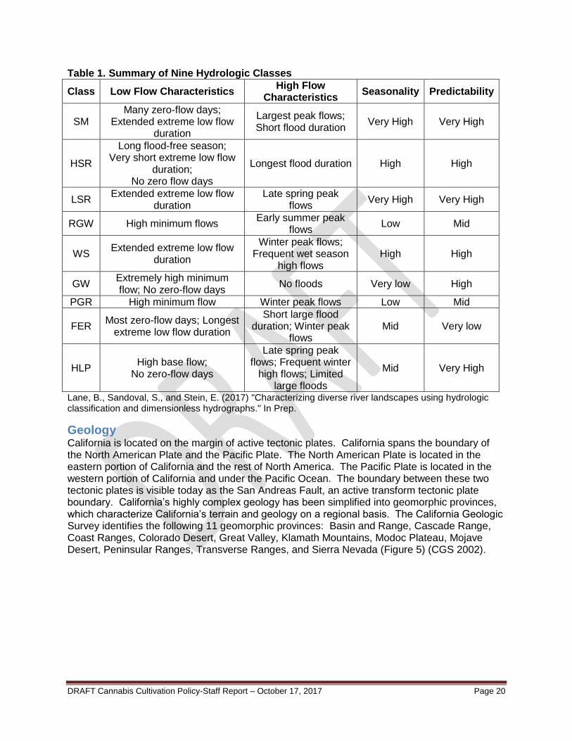
DRAFT Cannabis Cultivation Policy-Staff Report – October 17, 2017 Page 20
Table 1. Summary of Nine Hydrologic Classes
Class Low Flow Characteristics High Flow
Characteristics Seasonality Predictability
SM Many zero-flow days;
Extended extreme low flow duration
Largest peak flows; Short flood duration
Very High Very High
HSR
Long flood-free season; Very short extreme low flow
duration; No zero flow days
Longest flood duration High High
LSR Extended extreme low flow
duration Late spring peak
flows Very High Very High
RGW High minimum flows Early summer peak
flows Low Mid
WS Extended extreme low flow
duration
Winter peak flows; Frequent wet season
high flows High High
GW Extremely high minimum flow; No zero-flow days
No floods Very low High
PGR High minimum flow Winter peak flows Low Mid
FER Most zero-flow days; Longest
extreme low flow duration
Short large flood duration; Winter peak
flows Mid Very low
HLP High base flow;
No zero-flow days
Late spring peak flows; Frequent winter
high flows; Limited large floods
Mid Very High
Lane, B., Sandoval, S., and Stein, E. (2017) "Characterizing diverse river landscapes using hydrologic classification and dimensionless hydrographs." In Prep.
Geology California is located on the margin of active tectonic plates. California spans the boundary of the North American Plate and the Pacific Plate. The North American Plate is located in the eastern portion of California and the rest of North America. The Pacific Plate is located in the western portion of California and under the Pacific Ocean. The boundary between these two tectonic plates is visible today as the San Andreas Fault, an active transform tectonic plate boundary. California’s highly complex geology has been simplified into geomorphic provinces, which characterize California’s terrain and geology on a regional basis. The California Geologic Survey identifies the following 11 geomorphic provinces: Basin and Range, Cascade Range, Coast Ranges, Colorado Desert, Great Valley, Klamath Mountains, Modoc Plateau, Mojave Desert, Peninsular Ranges, Transverse Ranges, and Sierra Nevada (Figure 5) (CGS 2002).

DRAFT Cannabis Cultivation Policy-Staff Report – October 17, 2017 Page 21
DRAFT Cannabis Cultivation Policy-Staff Report – October 17, 2017 Page 22
Salmonid Species Anadromous members of the taxonomic family Salmonidae, collectively known as anadromous salmonids, adapted over many thousands of years to the natural environment and climate variability of California. The three most historically abundant anadromous salmonid species native to California are Chinook salmon, coho salmon, and steelhead. Each of these anadromous salmonid species have multiple distinct populations, called evolutionarily significant units (ESUs), distinct population segments (DPSs), or distinct taxonomic entities4 (DTEs). These species’ characteristic anadromous lifestyle allows them to benefit from the relative safety of inland streams and estuaries during spawning, incubation, and rearing as well as the greater productivity of the ocean environment during maturation. Human modification of the environment in California, particularly over the last 200 years, has significantly impacted the viability of anadromous salmonid populations in the state. Currently, three ESUs and DPSs of anadromous salmonids are listed as endangered and seven as threatened under the Federal Endangered Species Act (ESA) and/or the California Endangered Species Act (CESA). Six additional ESUs, DPSs, or DTEs are listed as species of concern or species of special concern by the National Marine Fisheries Service (NMFS) and/or CDFW, respectively. The presence of these listed and special-status5 populations in the Policy regions is listed in Table 2. Information regarding the distributions, life histories, and threats to the viability of these special-status anadromous salmonids, as well as other salmonids of interest, is provided in Appendix 2.
4 DTEs are populations given distinct consideration by CDFW, but they may be grouped as a larger ESU
by federal entities. 5 For the purposes of the Policy, the term “listed and special-status” refers to species or distinct
populations that are federally listed as threatened or endangered, listed as threatened or endangered by the state of California, listed as a species of concern by NMFS, or listed as species of special concern by CDFW. No California salmonids were federally proposed for listing as threatened or endangered or designated as a State Candidate for threatened or endangered listing by the state of California at the time of the preparation of this report (CDFW 2017b).

DRAFT Cannabis Cultivation Policy-Staff Report – October 17, 2017 Page 23
Table 2: Listed and Special-Status Anadromous Salmonids by Policy Region
Policy Region
Special-Status Anadromous Salmonid
Population (ESU/DPS/DTE)
Klamath North Coast
North Central Coast
Tahoe South
Central Coast
Upper Sacram-ento**
Middle Sacram-
ento
South Sacram-
ento
San Joaquin
Mono Kern South Coast
North Eastern Desert
South Eastern Desert
South Oregon/Northern California Coastal
Chinook Salmon ESU S
Upper Klamath-Trinity River Chinook Salmon
Fall-Run DTE* S
Spring-Run DTE*
S
Klamath Mountains Province Steelhead DPS
S
South Oregon/Northern California Coastal Coho
Salmon ESU f/c - T
f/c - T
f/c - T
California Coastal Chinook Salmon ESU
f - T f - T
Northern California Steelhead DPS
f - T f - T
Central California Coast Coho Salmon ESU
f/c - E f/c - E
Central California Coast Steelhead DPS
f - T f - T f - T
Key: f = Federal Endangered Species Act c = California Endangered Species Act T = Threatened E = Endangered S = California Special Concern ^ = Federal Special Concern ESU = Evolutionary Significant Unit DPS = Distinct Population Segment DTE = Distinct Taxonomic Entities*
* DTEs are populations given distinct consideration by CDFW, but they may be grouped as a larger ESU by Federal entities. ** Historically the Upper Sacramento Region contained populations listed in this table, but upstream migration is blocked by Keswick Dam.
DRAFT Cannabis Cultivation Policy-Staff Report – October 17, 2017 Page 24
Table 2: Listed and Special-Status Anadromous Salmonids by Policy Region (continued)
Policy Region
Special-Status Anadromous Salmonid
Population (ESU/DPS/DTE)
Klamath North Coast
North Central Coast
Tahoe South
Central Coast
Upper Sacram-ento**
Middle Sacram-
ento
South Sacram-
ento
San Joaquin
Mono Kern South Coast
North Eastern Desert
South Eastern Desert
Sacramento River Winter-Run
Chinook Salmon ESU f/c - E f/c - E
Central Valley Chinook Salmon
Spring-Run ESU
f/c - T f/c - T
Fall-Run DTE* S^ S^ S^ S^
Late Fall-Run DTE*
S^ S^ S^ S^
California Central Valley Steelhead DPS
f - T f - T f - T
South Central California Coast Steelhead DPS
f - T
Southern California Coast Steelhead DPS
f- E
Key: f = Federal Endangered Species Act c = California Endangered Species Act T = Threatened E = Endangered S = California Special Concern ^ = Federal Special Concern ESU = Evolutionary Significant Unit DPS = Distinct Population Segment DTE = Distinct Taxonomic Entities*
* DTEs are populations given distinct consideration by the CDFW, but they may be grouped as a larger ESU by Federal entities. ** Historically the Upper Sacramento Region contained populations listed in this table, but upstream migration is blocked by Keswick Dam.
DRAFT Cannabis Cultivation Policy-Staff Report – October 17, 2017 Page 25
Water Quality Impairment – Clean Water Act Section 303(d) List The Federal Clean Water Act gives states the primary responsibility for protecting and restoring surface water quality. Under the Clean Water Act, states that administer the Clean Water Act must review, make necessary changes, and submit the Clean Water Act section 303(d) lists to the United States Environmental Protection Agency (USEPA). Clean Water Act section 305(b) requires each state to report biennially to USEPA, on the condition of its surface water quality. The USEPA has issued guidance to states which requires the two reports to be integrated. For California, this combined report is called the California 303(d)/305(b) Integrated Report. The State Water Board and the nine Regional Water Quality Control Boards (collectively Water Boards) assess water quality monitoring data for California’s surface waters every two years to determine if they contain pollutants at levels that exceed protective water quality standards. Waterbodies and pollutants that exceed protective water quality standards are placed on the State Water Board’s 303(d) List. This determination in California is governed by the Water Quality Control Policy for developing California’s Clean Water Act Section 303(d) List. USEPA must approve the 303(d) List before it is considered final. Placement of a waterbody and pollutant that exceeds protective water quality standards on the 303(d) List, initiates the development of a Total Maximum Daily Load (TMDL). In some cases, other regulatory programs will address the impairment instead of a TMDL. For the Clean Water Act Section 305(b) Report, the Water Boards place the waterbody segments that were assessed into one of USEPA’s five Integrated Report beneficial use report categories. For this assessment, all readily available data are used to evaluate beneficial use attainment including aquatic life, drinking water supply, fish consumption, non-contact recreational, and swimming. The 2012 Integrated Report for the Clean Water Act Section 303(d) List was reviewed for water quality impairments on streams to provide a generalized overview of 303(d) impairments in each of the Policy’s nine priority regions. It is anticipated that this review and a generalized overview of 303(d) impairments in each of the Policy’s five remaining regions will be developed and added to the final Staff Report. State Water Board staff reviewed State Water Board Geographic Information System (GIS) data layers for 303(d) water quality impaired streams in the state. The 303(d) impaired streams were overlaid with the USGS NHD 12 digit Hydrologic Unit Code (HUC 12) watersheds. For the purposes of this analysis, if a HUC 12 watershed has a 303(d) impairment within its boundary the whole watershed is included in the area analysis even though only a portion of the watershed may have the impairment. The areas of the impaired HUC 12 watersheds were then compared to the total watershed area of the region. The impairments are discussed for each Policy priority region in Table 3, as a percentage of total area impaired by a water quality contaminant category or contaminant name. Specific pollutants and their affected stream reaches are discussed in more detail in the 2012 303(d) List, and in the Water Boards’ Basin Plan(s) for each of the Policy priority regions.
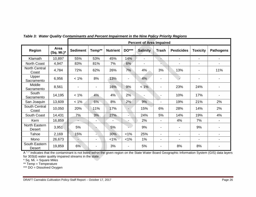
DRAFT Cannabis Cultivation Policy-Staff Report – October 17, 2017 Page 26
Table 3: Water Quality Contaminants and Percent Impairment in the Nine Policy Priority Regions
Percent of Area Impaired
Region Area
(Sq. Mi.)* Sediment Temp** Nutrient DO*** Salinity Trash Pesticides Toxicity Pathogens
Klamath 10,897 55% 53% 45% 14% - - - - -
North Coast 4,947 83% 81% 7% 6% - - - - -
North Central Coast
4,784 72% 62% 26% 7% 4% 3% 13% - 11%
Upper Sacramento
6,956 < 1% 8% 13% - 4% - - - -
Middle Sacramento
8,561 - - 16% 9% < 1% - 23% 24% -
South Sacramento
14,195 < 1% 4% 4% 2% - - 10% 17% -
San Joaquin 13,609 < 1% 6% 8% 2% 9% - 19% 21% 2%
South Central Coast
10,050 20% 11% 17% - 15% 6% 28% 14% 2%
South Coast 14,431 7% 3% 27% - 24% 5% 14% 19% 4%
Kern 16,859 - - - - 2% - 4% 7% -
North Eastern Desert
3,951 5% - 5% - 9% - - 9% -
Tahoe 2,169 15% - 30% <1% 25% - - - -
Mono 26,673 - - <1% <1% 1% - - - -
South Eastern Desert
19,859 6% - 3% - 5% - 8% 8% -
A “-“ indicates that the contaminant is not listed within the given region on the State Water Board Geographic Information System (GIS) data layers for 303(d) water quality impaired streams in the state. * Sq. Mi. = Square Miles ** Temp = Temperature *** DO = Dissolved Oxygen

DRAFT Cannabis Cultivation Policy-Staff Report – October 17, 2017 Page 27
Overview of Cannabis Cultivation Impacts Predominantly unregulated for years, thousands of cannabis cultivators have developed cultivation sites in remote areas of the state near streams. In many cases the routine cannabis cultivation practices result in damage to streams and wildlife. These practices (e.g., clearing trees, grading, and road construction) are often conducted in a manner that causes large amounts of sediment to flow into streams during rains. The sediment smothers gravel spawning beds needed by native fish. The cannabis cultivators also discharge pesticides, fertilizers, fuels, trash, and human waste around the sites, that then discharges into waters of the state. In the North Coast Region, the state has invested millions of dollars to restore streams damaged by decades of timber harvesting. Cannabis cultivation is now reversing the progress of these restoration efforts. In addition to these water quality discharge related impacts, cannabis cultivators also impair water quality and aquatic habitat by diverting water from streams in the dry season, when flows are low. Diversion of flow during the dry season often completely dries up streams, stranding or killing native fish. The impacts of these diversions have been exacerbated in recent years by periods of drought. CDFW has received dewatering reports for at least 19 streams in northern California, all of which contain anadromous fish listed as threatened or endangered by the state and/or federal government. Diversions for cannabis cultivation also are known to occur in hundreds of streams with Coho salmon in the North Coast region and in countless other streams throughout the state, demonstrating that water quality and habitat-related impacts from cannabis cultivation are widespread. Cannabis cultivation has been increasing in recent years, and the expansion is accelerating with the passage of MCRSA and AUMA legislation. A recent CDFW study (Bauer et al. 2015), using aerial surveys of four small watersheds in Humboldt and Mendocino counties found that the number of acres in cannabis cultivation doubled from 2009 to 2012, with an estimated 500 individual operations and approximately 30,000 plants in each of these small watersheds. The study concluded that water demand for cannabis cultivation has the potential to divert substantial portions of streamflow in the studied watersheds, with an estimated flow reduction of up to 23 percent of the annual seven-day low flow in the least impacted of the studied watersheds. Estimates from the other study watersheds indicate that water demand for cannabis cultivation exceeds the streamflow during the low-flow period. In the most impacted watersheds, diminished streamflow is likely to: have lethal or sub-lethal effects on state- and federally-listed salmon and steelhead trout; and cause further decline of sensitive amphibian species. Bauer et al. concluded that cannabis cultivation on private land has grown so much in the North Coast region that Coho salmon, a federal and state listed endangered species, may go extinct in the near future if the impacts of cannabis cultivation are not addressed immediately. Rare (listed) and sensitive species affected by water diversion for cannabis cultivation in the North Coast region include: Coho salmon; Chinook salmon; steelhead trout; coastal cutthroat trout; southern torrent salamander; red legged frog; northern spotted owl; and Pacific fisher. Other species throughout the state such as deer, bear, and various birds are also being harmed by cannabis cultivation-related impacts to streams. .

DRAFT Cannabis Cultivation Policy-Staff Report – October 17, 2017 Page 28
Prior to the MRCSA legislation, the Legislature approved the Governor’s proposed budget, which provided positions for a pilot project to reduce environmental damage caused by cannabis cultivation activities with direction “to improve the prevention of illegal stream diversions, discharges of pollutants into waterways, and other water quality impacts associated with marijuana production.” The pilot project included the collaboration of CDFW, the Central Valley Regional Water Board, North Coast Regional Water Board, and the State Water Board.
The pilot project worked to address the damage to natural resources from cannabis cultivation where high levels of such cultivation are known to occur. The agencies formed a multi-agency task force (Task Force) that coordinates efforts to provide public outreach and education, perform site inspections, handle public complaints, and pursue enforcement actions related to cannabis cultivation activities. The North Coast Regional Water Board (Region 1) and Central Valley Regional Water Board (Region 5) adopted regional board specific water quality orders to address discharges related to cannabis cultivation under Orders R1-2015-0023 and R5-2015-0113, respectively. MCRSA and AUMA have subsequently directed CDFW and the State Water Board to expand the pilot project and Task Force statewide to address the environmental impacts of cannabis cultivation.6 Reports from Task Force inspections conducted during the pilot program document extensive adverse environmental impacts to aquatic resources from cannabis cultivation activities, including increased erosion (e.g., road construction and site development on slopes greater than 30 percent), stream habitat degradation (e.g., water storage, site development, and road construction in and near waters of the state), and unlawful water diversion that severely limits the supply available for the public and wildlife/fish.
6 Fish and Game Code section 12029(c) and Water Code section 13276(b).

DRAFT Cannabis Cultivation Policy-Staff Report – October 17, 2017 Page 29
BACKGROUND AND RATIONALE FOR POLICY
REQUIREMENTS FOR WATER DIVERSION AND WASTE
DISCHARGES ASSOCIATED WITH CANNABIS CULTIVATION The State Water Board developed the Policy in accordance with Water Code section 13149 to establish Requirements to address impacts associated with the diversion of water and waste discharges related to cannabis cultivation. Furthermore, pursuant to Water Code section 13276, the Water Boards may establish or adopt individual or general waste discharge requirements to address discharges of waste resulting from cannabis cultivation under Division 10 of the Business and Professions Code and associated activities. In addressing these discharges, the Water Boards must include conditions to address items that include, but are not limited to, the following:
Site development and maintenance, erosion control, and drainage features
Stream crossing installation and maintenance
Riparian and wetland protection and management
Soil disposal
Water storage and use
Irrigation runoff
Fertilizers and soil
Pesticides and herbicides
Petroleum products and other chemicals
Cannabis cultivation waste
Refuse and human waste
Cleanup, restoration, and mitigation
These 12 categories of discharge to waters of the state can generally be grouped according to the following types of discharge:
a. Discharges of sediment from land disturbance activities (e.g. road construction, grading), improper construction or maintenance of road stream crossings and drainage culverts; or improper stabilization and maintenance of disturbed areas, unstable slopes, and construction material (e.g., spoil piles, excavated material);
b. Discharges from land disturbance and development within and adjacent to wetlands and riparian zones;
c. Discharges of fertilizers and pesticides7;
7 The term “pesticide” is defined by California Code of Regulations Title 3. Division 6. Section 6000 as: (a)
Any substance or mixture of substances that is a pesticide as defined in the Food and Agricultural Code and includes mixtures and dilutions of pesticides; (b) As the term is used in Section 12995 of the California Food and Agricultural Code, includes any substance or product that the user intends to be used for the pesticidal poison purposes specified in Food and Agricultural Code sections 12753 and 12758. Per California Food and Agricultural Code section 12753(b), the term “pesticide” includes any of the following: Any substance, or mixture of substances which is intended to be used for defoliating plants, regulating plant growth, or for preventing, destroying, repelling, or mitigating any pest, as defined in
DRAFT Cannabis Cultivation Policy-Staff Report – October 17, 2017 Page 30
d. Spills or leaks of fuels, lubricants, hydraulic oil, or other chemicals associated with water diversion pumps, construction equipment, or other equipment; and
e. Discharges of trash, household refuse, or domestic wastewater. Implementation of the Policy Requirements will reduce water quality degradation and water diversion impacts associated with cannabis cultivation. Additional background and rationale regarding potential cannabis cultivation impacts to water quality from diversions and waste discharges related to cannabis cultivation are discussed below. As impacts associated with water diversions affect only a subset of cannabis cultivation sites (i.e., those with diversions) the background and rationale for Water Diversion, Storage, and Use follows the discussion of the background and rationale for more generally applicable impacts associated with cannabis cultivation that do not involve a water diversion.
Cleanup, Restoration, and Mitigation Outdoor cannabis cultivation in California typically occurs on undeveloped parcels (as opposed to traditional agricultural lands). In addition to the cannabis cultivation area, there is also typically an indoor nursery and other support facilities (e.g., water supply and distribution, storage bays for soil amendments, generator(s) for power supply, storage sheds, access roads, etc.). Site grading is often a necessary first step to construct these facilities and the resultant disturbed area is vulnerable to increased erosion and sedimentation. Minimizing the extent of disturbance when developing a new site and performing associated clean up, restoring vegetation to pre-cannabis cultivation conditions, and mitigating any impacts to native vegetation through replanting or mulching, will reduce the threat to water quality. Within riparian zones, revegetation of disturbed areas is critical to prevent sediment, nitrogen, phosphorus, pesticides, and other pollutants from reaching a watercourse. Riparian buffers also provide valuable habitat for fish and wildlife (e.g., providing food, shelter, cover, and a travel corridor for wildlife). Requirements contained in Policy Attachment A, Section 2: “Cleanup, Restoration, and Mitigation” specifically address these impacts.
Constituents of Concern The Policy prohibits direct discharge of waste to surface waters and requires implementation of Requirements to prevent storm water mobilization of constituents of concern to waters of the state, which includes groundwater and surface waterbodies. Water quality related constituents of concern associated with cannabis cultivation discharges include nitrogen, pathogens (represented by coliform bacteria), phosphorus, salinity, and turbidity. Water quality can be affected by excessive use of fertilizer, soil amendments, or other sources. The constituents have the potential to discharge to groundwater by infiltration and to other waters of the state by either surface runoff or by groundwater seepage. Each of the constituents of concern is discussed briefly below:
Nitrogen. Nitrogen compounds may exist in a number of chemical compounds (ammonia, nitrite, nitrate, and organic nitrogen). Nitrogen may exist in any of the compounds, although nitrate is the primary compound absorbed by plants. Nitrate is
Section 12754.5, which may infest or be detrimental to vegetation, man, animals, or households, or be present in any agricultural or nonagricultural environment whatsoever. In layman’s terms, “pesticide” includes rodenticides, herbicides, insecticides, fungicides, and disinfectants.

DRAFT Cannabis Cultivation Policy-Staff Report – October 17, 2017 Page 31
also the most mobile of the nitrogen compounds in the environment. The potential for degradation depends on fertilizer application method, loading rate, crop uptake, and processes in the vadose zone related to immobilization and/or denitrification. The Policy requires compliance with Requirements, which include practices that limit the amount of nitrogen applied and control runoff from the cannabis cultivation area. In addition, cannabis cultivation sites that are enrolled in Tier 2 under the General Waste Discharge Requirements for Discharges of Waste Associated with Cannabis Cultivation Activities (Cannabis General Order) and that have combined activities to create a cultivation area on a parcel that is equal to or larger than one acre, must submit a Nitrogen Management Plan8. Additional information on nitrogen is available below in the discussion of Fertilizers, Pesticides, Petroleum Products and Other Chemicals
Pathogens and Microorganisms. Pathogens and other microorganisms are present in manure-based fertilizers, compost, biosolids, and soil amendments. Composting manure and/or biosolids will reduce the concentration of pathogens but not eliminate their presence. Exposure to sunlight will further reduce pathogen content. Coliform bacteria are used as a surrogate (indicator) because they are excreted by warm-blooded animals, are present in high numbers, survive in the environment similar to pathogenic bacteria, and are easy to detect and quantify. Public contact is minimized through physical controls and/or notification. The Policy requires implementation of Requirements, which include riparian setbacks, as well as other practices that limit potential for pathogen discharges from cannabis cultivation activities. Riparian setback Requirements reduce pathogenic risks by coupling pathogen inactivation rates with groundwater travel time to a well or other potential exposure route (e.g., water contact activities). In general, a substantial unsaturated zone reduces pathogen survival compared to saturated soil conditions. Fine grained (silt or clay) soil particles reduce the rate of groundwater transport and therefore are generally less likely to transport pathogens; coarse grained soil particles or fracture flow groundwater conditions may be more likely to transport pathogens.
Phosphorus. Phosphorus compounds may exist in a number of chemical compounds (orthophosphate, polyphosphate, organic phosphate, phosphoric acid, and others). Phosphorus is quickly oxidized to phosphate, which is the compound absorbed by plants. Phosphate strongly adsorbs to soil particles and therefore has limited mobility in the environment. The potential for degradation depends on fertilizer application method, loading rate, and crop uptake. The Policy requires compliance with Requirements, which include practices that control runoff from the cannabis cultivation area.
Salinity. Salinity is a measure of dissolved solids in water. Excessive salinity can reduce the beneficial uses of water. Salinity consists of both volatile (organic) and fixed (inorganic) fractions. In a well-operated cultivation system, volatile dissolved solids in percolate will be reduced to negligible concentrations. The best approach for addressing salinity is through source control activities. The Policy requires compliance with Requirements, which include practices that will limit the amount of salinity discharged from cultivation activities.
Turbidity. Turbidity can be caused by suspended sediment, which can diffuse sunlight and absorb heat. This can increase temperature and reduce light available for
8 The Nitrogen Management Plan is required to account for all of the nitrogen applied to cannabis
cultivation areas (dissolved in irrigation water, originating in soil amendments, and applied fertilizers) and describe procedures to limit excessive fertilizer application.
DRAFT Cannabis Cultivation Policy-Staff Report – October 17, 2017 Page 32
algal photosynthesis. If the turbidity is caused by suspended sediment, it can be an indicator of erosion, either natural or manmade. In streams supporting wildlife, suspended sediments pose additional hazards. Suspended sediments can clog the gills of fish, and settled sediments can clog gravel beds, smother fish eggs, and impact aquatic life. The sediment can also carry pathogens, pollutants, and nutrients, further exacerbating water quality impacts. Excessive nutrient loads in water bodies resulting from human activities, such as agricultural discharges, can encourage the development of harmful algal blooms or cause excessive growth of algae and aquatic plants in streams, also thereby affecting turbidity. Severe algal growth blocks light that is needed for aquatic plants, to grow. When algae and aquatic plants die and decay, it leads to low levels of dissolved oxygen in the water. This in turn, can kill aquatic life. (NOAA, 2017) Most of the nine Regional Water Board’s water quality objectives for turbidity require that surface waters (except ocean waters) be free of changes in turbidity that cause nuisance or adversely affect the beneficial use of water. Water quality control plans (often referred to as Basin Plans) may contain specific turbidity and suspended sediment requirements; implementation of applicable Policy Requirements will be effective in controlling turbid discharges. In some cases, the cannabis cultivator will have to implement multiple Policy Requirements, or increase the density or application of Policy Requirements (e.g., storm water measures) to achieve water quality protection.
Requirements contained in Policy Attachment A, Section 2: “Fertilizers, Poisons, and Petroleum Products” specifically address the impacts discussed in this “Constituents of Concern” section. Also see Policy Attachment A, Section 1: “General Requirements and Prohibitions” and “Cannabis General Water Quality Certification.”
Cultural Resource Protection Cannabis cultivation often occurs in undeveloped or lightly disturbed sites. Frequently, cannabis cultivation requires land clearance and ground disturbing activities as part of site preparation. As such, cannabis cultivation has a higher risk of disturbing previously undisturbed human remains, archeological resources, and sites that are of cultural value to California Native American tribes. Accordingly, the Policy includes Requirements to protect these resources from the negative impacts of cannabis cultivation. Requirements contained in Policy Attachment A, Section 1: “General Requirements and Prohibitions” specifically address these impacts.
Fertilizers, Pesticides, Petroleum Products and Other Chemicals The over or improper use and storage of potting soil, amendments, fertilizers, pesticides, poisons and petroleum products can lead to significant soil and water contamination. Each of these is discussed briefly below.
Fertilizers. Potting soil, soil amendments, and fertilizers can contain excess nutrients, particularly nitrogen and phosphorus (see discussion under Constituents of Concern above), that can contribute to toxic algae blooms, and deplete the dissolved oxygen that fish and other aquatic species need to survive. Nitrogen is a primary plant nutrient that is taken up by plants as nitrate or ammonium ions. Nitrate is mobile in the environment and can move with soil water to plant roots where uptake can occur; ammonium nitrogen is sorbed to soil particles and has limited mobility in the environment. All forms of nitrogen can be converted to nitrate, by microbial activity, under the proper conditions (e.g., temperature, aeration, moisture, etc.).

DRAFT Cannabis Cultivation Policy-Staff Report – October 17, 2017 Page 33
Nitrogen or nitrogen compounds may be lost to the atmosphere by the process of denitrification or by ammonia volatilization. Nitrate may be leached below the root zone by percolation. Erosion of nitrogen containing materials may transport nitrogen containing materials to surface water.
Symptoms of nitrogen deficiency in plants include slow growth, yellow green color (chlorosis), “firing” of tips and margins of leaves beginning with more mature leaves. Chlorosis is usually more pronounced in older plant tissue since nitrogen is mobile within plants and tends to move from older to younger tissue when nitrogen availability is limited. (CPHA 1980)
The rate of nitrogen uptake by crops changes during the growing season. For planning and nutrient balances, the rate of nitrogen uptake can be approximately correlated to the rate of plant transpiration. Consequently, the pattern of nitrogen uptake is subject to many environmental and management variables and is crop specific.
Some forage crops can have higher nitrogen uptake rates than those in agricultural publications. “Luxury consumption” may occur in the presence of surplus nitrogen and result in higher than normal crop uptake rates.
Generally young plants absorb ammonium more readily than nitrate; however, as the plant ages the reverse is true. Soil conditions that promote plant growth (warm and well aerated) also promote the microbial conversion of ammonium to nitrate. As a result, nitrate is generally more abundant when growing conditions are most favorable. (Brown and Caldwell, 2007)
The Policy allows up to 1.4 times the crop uptake rate to compensate for the nitrogen that is not plant available or lost through denitrification or ammonia volatilization, and also allows for short-term additional nitrogen application if needed based on visual observation of the plant and laboratory analysis of plant tissue demonstrating limited nitrogen availability. The factor of 1.4 is designed to address the limited data regarding cannabis nitrogen uptake rates, and the variable nitrogen cycle processes described above. Other Requirements in the Policy provide adequate protection of water quality that substantiates use of the increased application factor (1.4).
A 2004 study at the University of Northern British Columbia evaluated nitrogen uptake values for Cannabis sativa (Forrest, 2004). The study reported a nitrogen uptake rate of 228 lbs/acre/year. Using the application factor of 1.4, allows a nitrogen application rate of 319 lbs/acre/year. The application rate includes all sources of nitrogen, including soil amendments, bulk fertilizers, and liquid fertilizers. Because cannabis grown for medical or personal use is not cultivated as densely as hemp, the Policy limits nitrogen application using the units “pounds/canopy acre/year.” Typically, one canopy acre occupies more than one acre of land. Using the simpler units “pounds/acre/year” would result in the application of nitrogen beyond the crop need.
Pesticides. Pesticides can lead to many unintended negative effects, and are easily mobilized by storm water runoff. Pesticides need to be used and stored in a manner that prevents them from entering waters of the state. Poisons used to exterminate garden pests such as rats, mice, gophers, and moles can move up through the food chain and cause secondary poisoning and mortality of family pets, and predators such as owls, bobcats, foxes, and the Pacific Fisher (Pekania pennanti). There are many effective
DRAFT Cannabis Cultivation Policy-Staff Report – October 17, 2017 Page 34
practices for controlling pests and enhancing soil and plant growth that do not require chemical fertilizers or pesticides. Business and Professions Code section 26060(d) requires the California Department of Pesticides Regulation (DPR) to develop guidelines for the use of pesticides in cannabis cultivation and guidelines for maximum tolerances for pesticides and other foreign object residue in harvested cannabis. Currently no pesticides have been approved by regulatory agencies for use on cannabis. In 2015, DPR published Legal Pest Management Practices for Cannabis Growers in California (CDPR 2015), which lists active ingredients that are exempt from residue tolerance requirements. The active ingredients that can be legally used on cannabis plants in California are either exempt from registration requirements or registered for a use that’s broad enough to include its use on cannabis. Federal law requires that the use of pesticides be consistent with product labeling. The Policy requires that all pesticide application is done in compliance with labelling instructions and other applicable laws and regulations. The Policy further requires that pesticides be used and stored in a manner that ensures that pesticides will not enter or be released to waters of the state.
Petroleum Products. Petroleum products (e.g., gasoline, diesel, oil, and grease) are toxic to aquatic wildlife and commonly spill or leak from vehicles, equipment, and storage areas. If petroleum products are mobilized, they have the potential to discharge to waters of the state during rain events.
Requirements contained in Policy Attachment A, Section 5: “Nitrogen Management Plan” and Section 2: “Fertilizers and Soils” specifically address these impacts.
General Water Quality Certification Activities that involve construction and other work in waters of the United States may require a permit from the Army Corps pursuant to section 404 of the Clean Water Act. Section 401 of the Clean Water Act requires every applicant for a federal license or permit to provide the licensing or permitting federal agency with a section 401 water quality certification that the project will be in compliance with state water quality standards and implementation plans promulgated pursuant to section 303 of the Clean Water Act, and other appropriate requirements of state law. The State Water Board may issue a decision on a water quality certification application.9 State water quality certification conditions become conditions of any federal license or permit for the project. The State Water Board may issue a general water quality certification for a class or classes of activities that, as here, are the same or similar, or involve the same or similar types of discharges and possible adverse impacts to water quality if it determines that these activities are more appropriately regulated under a general certification rather than individual certifications.10
Dredge or Fill Materials Some activities related to establishing or maintaining cannabis cultivation sites or access roads may involve the discharge of dredge or fill material into waters of the United States (US) or waters of the state (e.g., excavation for a culvert, irrigation pipe, or pump structure installation). Dredged material is material that is excavated or dredged from a waterbody.11 Fill material is material placed into a waterbody that has the effect of either replacing any portion of the water
9 California Code of Regulations title 23 section 3838.
10 California Code of Regulations title 23 section 3861.
11 Cf. Code of Federal Regulations section 323.2(c) [defining “dredged material” under federal law].
DRAFT Cannabis Cultivation Policy-Staff Report – October 17, 2017 Page 35
with dry land or changing the bottom elevation of the waterbody.12 Cannabis cultivators are required to obtain authorization for discharges of dredge or fill materials to the waters of the US or to the non-federal waters of the state as described below:
Discharges of dredged or fill material to waters of the US are regulated by the Army Corps under section 404 of the Clean Water Act and a water quality certification under section 401 of the Clean Water Act. Exempt activities include, among other things: normal farming, ranching and silviculture activities; maintenance of currently serviceable structures such as dikes, dams, levees, bridge abutments or approaches, and transportation structures; construction or maintenance of irrigation ditches, or maintenance (but not construction) of drainage ditches; and construction of farm roads or forest roads in compliance with applicable best management practices. Converting a wetland to a non-wetland or conversion from one wetland use to another (such as from silviculture to farming) is not exempt. Dischargers, including cannabis cultivators, proposing non-exempt discharges of dredged or fill material are required to obtain a section 404 permit from the Army Corps. Section 401 of the Clean Water Act requires an applicant for a dredge and fill permit to provide certification from the state that the proposed activity also complies with state water quality standards. Any conditions in a section 401 water quality certification are incorporated into the section 404 permit. The Army Corps may not issue a section 404 permit if the state denies certification. In California, the Water Boards issue water quality certifications. California law requires dischargers of dredged or fill material to obtain waste discharge requirements for those activities, whether or not the discharger obtains a section 404 permit and section 401 water quality certification.
The Cannabis General Order serves as waste discharge requirements for cannabis-cultivation discharges of dredge and fill materials. Cannabis cultivators enrolled in and conducting activities in compliance with the Cannabis General Order will not be required to obtain coverage for such activities under Water Quality Order No. 2004-0004-DWQ (Statewide General Waste Discharge Requirements for Dredged or Fill Discharges to Waters Deemed by the U.S. Army Corps of Engineers to be Outside of Federal Jurisdiction), Water Quality Order No. 2003-0017-DWQ (Statewide General Waste Discharge Requirements for Dredged or Fill Discharges that Have Received State Water Quality Certification), or any successor order. Cannabis cultivators that require a section 401 water quality certification may either seek coverage under the Cannabis General Water Quality Certification or apply to the State Water Board or applicable Regional Water Board for a site-specific water quality certification.
12
Cf. 33 Code of Federal Regulations section 323.2(e) [defining “dredged material” under federal law].
DRAFT Cannabis Cultivation Policy-Staff Report – October 17, 2017 Page 36
The Policy includes a Cannabis General Water Quality Certification for cannabis cultivation activities that may require a federal permit. Cannabis cultivators seeking Clean Water Act section 401 water quality certification for a project must notify the appropriate Regional Water Board or State Water Board 60 days prior to the proposed commencement of the activity and submit information regarding the construction schedule and other relevant information. Unless the Regional Water Board or State Water Board determines that the project or activity does not meet the specified criteria for coverage under the General Water Quality Certification, the General Water Quality Certification will provide section 401 water quality certification coverage for the federal permit required for that project. Cannabis cultivators must not commence the activity until the appropriate Regional Water Board or State Water Boar notifies the cannabis cultivator that the work is authorized. A list of projects authorized by this General Water Quality Certification will be posted on the appropriate Regional Water Board and State Water Board’s website and will serve as notice to the United States Army Corps of project coverage. Projects that do not meet the criteria for coverage under the General Water Quality Certification must apply for individual certification. The General Water Quality Certification contained in the Policy does not apply to activities that will: 1) result in significant unavoidable environmental impacts including permanent impacts to wetlands and other waters from dredge and fill activities, and/or violation of water quality standards; 2) result in the potential direct or indirect take of any listed species; or 3) expose people and/or structures to potential adverse effects from flooding, landslides or soil erosion.13 Requirements contained in Policy Attachment A, Section 1: “Cannabis General Water Quality Certification” specifically address these impacts.
Irrigation Runoff Irrigation runoff occurs when water is applied at too great a rate or quantity. Because site runoff cannot be used by the plant, it is considered a waste and unreasonable use of water. Additionally, runoff has the potential to transport sediment, pesticides, fertilizers, and other harmful constituents to waters of the state. As a result, irrigation that causes runoff can be considered a waste and unreasonable use of water as well as a threat to water quality and designated beneficial uses. Requirements contained in Policy Attachment A, Section 2: “Irrigation Runoff” specifically address these impacts.
Land Disturbance and Erosion Control Sediment from erosion is a major pollutant impairing many waters of the state. Excess sediment is defined as soil, rock, sand, silt, or clay that is delivered to waters in an amount that could negatively impact aquatic life, water quality, and designated beneficial uses. Improperly constructed or maintained roads, land development, and improper site maintenance are key factors that can contribute to erosion.
13
California Code of Regulations title 23 section 3861(d).
DRAFT Cannabis Cultivation Policy-Staff Report – October 17, 2017 Page 37
Sediment may degrade water quality in numerous ways. It reduces the amount of oxygen available to plants and animals and can carry fertilizers and other chemicals mobilizing them and carrying them into waterways. Once in the stream system, sediment fills in spawning gravels and negatively impacts salmon and steelhead’s ability to successfully form redds.14 The sediment reduces the available oxygen in redds that are formed, which can result in egg mortality and lower survival rates. Sedimentation in streams can cause or contribute to flooding, impede stream flow, increase water temperatures, and promote growth of toxic algae in the summer and fall.
Requirements contained in Policy Attachment A, Section 2: “Land Development and Maintenance, Erosion Control, and Drainage Features” specifically address these impacts.
Onsite Wastewater Treatment Systems The Policy does not authorize discharges of either industrial or domestic wastewater to onsite wastewater treatment systems. Treatment and disposal of domestic wastewater that uses subsurface disposal may be regulated by a local agency or a Regional Water Board, consistent with the Water Quality Control Policy for Siting, Design, Operation, and Maintenance of Onsite Wastewater Treatment Systems15 (OWTS Policy). To date, local agencies have only been authorized to permit domestic wastewater discharges. Discharges of industrial wastewater, such as hydroponic or irrigation tail water generated in indoor cultivation activities, must be permitted by the appropriate Regional Water Board or State Water Board. Use of cesspools is not authorized by the OWTS Policy and local agencies cannot approve their use. An outhouse may be acceptable in limited circumstances where the use is very limited, only human waste is discharged, and the use is protective of water quality. However, approval from the Regional Water Board must be obtained before initiating or continuing use of an outhouse. Factors that reduce the threat to water quality include a large property parcel size, relatively level terrain (topography), location outside flood hazard zones, very limited use, and no public access. Alternatives to an outhouse or cesspool include a properly designed septic system and leach field, a regularly serviced holding tank, or regularly serviced chemical toilets. Requirements contained in Policy Attachment A, Section 2: “Refuse and Domestic Waste” specifically address these impacts.
Refuse, Domestic Waste, and Cannabis Cultivation Waste Fish and Game Code section 5650 states that it is unlawful to deposit in, permit to pass into, or place where it can pass into the waters of the state, any substance or material that may harm fish, plant life, mammals, or bird life. This includes sediment/soil, petroleum products, fertilizers, pesticides, and poisons. Fish and Game Code section 5652 states that it is unlawful to deposit in, permit to pass into, or place where it can pass into the waters of the state or to abandon, dispose of or throw away, within 150 feet of the high water mark of waters of the state, any cans, bottles, garbage, motor vehicle or parts thereof, rubbish, litter, refuse, waste, debris, or the viscera or carcass of any dead mammal or the carcass of any dead bird.
14
Spawning areas or nests made by a salmon or trout. 15
The OWTS Policy is available online at: http://www.waterboards.ca.gov/water_issues/programs/owts/docs/owts_policy.pdf.
DRAFT Cannabis Cultivation Policy-Staff Report – October 17, 2017 Page 38
Many cannabis cultivation sites are on lands that have never included permanent habitation on the property. This has led to the development of temporary facilities, both for living quarters and for human needs (bathrooms and bathing), that do not meet industry standards. Many cannabis cultivation properties were selected because they were remote and there is often a lack of county or city services like water, power, sewer, or garbage collection at these sites. Improperly stored or disposed trash and biological waste can become a source of contamination in waters of the state, either by direct leaching or mixing of fluids, or runoff from irrigation or storm events. Additionally, cannabis cultivation, like other agricultural activities, generates waste (e.g., fertilizer containers, spent growth medium, soil amendments, etc.). If not managed properly, this waste has the potential to impact water quality and designated beneficial uses of waters of the state. Requirements contained in Policy Attachment A, Section 2: “Refuse and Domestic Waste” specifically address these impacts.
Riparian and Wetland Protection and Management Adequate riparian setbacks are the most important component to ensuring that land disturbance activities and discharges of waste do not negatively impact water quality or aquatic habitat. The Cannabis Policy establishes statewide riparian setbacks. Due to the infeasibility of setting riparian setbacks on a case-by-case basis based on site-specific conditions, setting these setbacks conservatively is appropriate to ensure that water quality and aquatic habitats will remain protected from potential cannabis cultivation impacts under a variety of site-specific conditions.
The riparian setback requirements in the Cannabis Policy reduce impacts to water quality, aquatic habitat, springs, and wetlands from clearing or conversion of riparian buffer zones or wetland areas for cannabis cultivation. Riparian buffers reduce water temperatures, provide cover for aquatic species, help to create and enhance aquatic habitat, support food production, and filter out sediment and pollution. Conversely, removal of vegetation in the riparian buffer zone can result in increased water temperatures due to solar radiation, reduction of quantity and quality of aquatic and terrestrial habitat, and increased bank instability and erosion. Disturbed areas within riparian buffer zones are more likely to discharge waste to surface water and/or result in loss of vegetation. In general, the riparian setback requirements in the Cannabis Policy are based on the State Water Board’s knowledge and expertise, information from the California Forest Practice Rules (FPRs) (Title 14, California Code of Regulations Chapters 4, 4.5 and 10), North Coast Regional Water Quality Control Board Waiver of Waste Discharge Requirements and General Water Quality Certification for Discharges of Waste Resulting from Cannabis Cultivation and Associated Activities or Operations with Similar Environmental Effects in the North Coast Region (Order No. R1-2015-0023), Central Valley Regional Water Quality Control Board Waste Discharge Requirements General Order for Discharges of Waste Associated with Medicinal Cannabis Cultivation Activities (Order No. R5-2015-0113), and other literature sources and laws16.
16
Fish and Game Code section 5652(a) which states "it is unlawful to deposit in, permit to pass into, or place where it can pass into the waters of the state or to abandon, dispose of or throwaway, within 150 feet of the high water mark of waters of the state, any cans, bottles, garbage, motor vehicle or parts thereof, rubbish, litter, refuse, waste, debris, or the viscera or carcass of any dead mammal or the carcass of any dead bird."

DRAFT Cannabis Cultivation Policy-Staff Report – October 17, 2017 Page 39
The FPRs have different Watercourse and Lake Protection Zone (WLPZ) setbacks for Class I, II, III, and IV watercourses and for slopes less than 30 percent, 30 to 50 percent, and greater than 50 percent. The WLPZ requirements also vary based on stream size and stream channel shape. The FPRs primarily address timberland harvest and management, but also allow for timberland conversion to other uses. Cannabis cultivators typically apply for the less-than-three-acre conversion under the FPRs when establishing a cannabis cultivation site in timberland. Timber activities for these conversions are not allowed within the WLPZ unless they are specifically approved by a local permit (e.g., county or city). In establishing the WLPZ setbacks for land conversions, FPRs state “In determining whether or not to make the written finding contained in Public Resource Code section 4621.2(a)(3)17 [for the proposed alternate use], the Director or the Board [State Board of Forestry and Fire Protection] upon appeal shall consider the following elements: whether the soil types and characteristics can support the proposed use, the erosion potential of the soils and slopes in light of the proposed use, potential mass land movement or subsidence possible harm to quality or quantity of water produced in the watershed, fire hazard and risk to the watershed, adverse effects to fish and wildlife from removal of habitat cover, and such other elements as appropriate.” (California Code of Regulations title 14, Chapter 4. Forest Practices section 1109.4.) While the FPRs serve the primary basis for the riparian setbacks in the Cannabis Policy, the FPRs’ riparian setbacks focus on sedimentation and riparian shade tree removal; they do not address the range of other potential water quality impacts associated with cannabis cultivation, including those stemming from fertilizer and pesticide use. For example, sediment can be physically filtered out of stormwater faster than dissolved nitrogen, which requires bacterial transformation to remove it. Thus, a narrower buffer would be needed to remove sediment than that needed to remove dissolved nitrogen. In Riparian Buffer Zones: Functions and Recommended Widths (Hawes and Smith 2005 as cited in Pennsylvania Land Trust Association 2014), the authors summarize the results of scientific studies, identifying the buffer widths needed for a buffer to effectively serve particular functions; and report the following ranges:
Erosion/sediment control 30 feet to 98 feet
Water quality: o Nutrients 49 feet to 164 feet o Pesticides 49 feet to 328 feet o Biocontaminants 30 feet or more (e.g. fecal matter)
Aquatic habitat:
17
Public Resource Code section 4621.2(a)(3) states “if the timberlands which are to be devoted to uses other than the growing of timber are zoned as timberland production zones under Section 51112 or 51113 of the Government Code, the application shall specify the proposed alternate use and shall include information the board determines necessary to evaluate the proposed alternate use. The board shall approve the application for conversion only if the board makes written findings that all of the following exist: (1) The conversion would be in the public interest. (2) The conversion would not have a substantial and unmitigated adverse effect upon the continued timber-growing use or open-space use of other land zoned as timberland preserve and situated within one mile of the exterior boundary of the land upon which immediate rezoning is proposed. (3) The soils, slopes, and watershed conditions would be suitable for the uses proposed if the conversion were approved.
DRAFT Cannabis Cultivation Policy-Staff Report – October 17, 2017 Page 40
o Wildlife 33 feet to 164 feet o Litter/debris 50 feet to 100 feet o Temperature 30 feet to 230 feet
Existing cannabis cultivation, especially in Northern California, is located within watersheds at higher elevations than traditional agriculture. Consequently, many of these cannabis cultivation sites are located in sensitive headwaters with high ecological value that need protective riparian setbacks. Headwater streams are smaller tributaries and springs that are located in the upper reaches of watersheds and represent the majority of the stream miles in the United States (Pennsylvania Land Trust Association 2014). Headwater streams that are located in the upper watersheds are generally considered Strahler first order or second order streams18. Based on an assessment of the mapped first order and second order stream miles in the United States Geological Survey National Hydrography Dataset Plus version 2.1 (Medium Resolution or 1:100,000 scale) geographic information system stream layer (NHD Plus V2.1 stream layer), approximately 60 percent of the mapped stream miles in California are first order streams and 80 percent are first or second order streams. In addition, due to their small size and lack of a defined channel, many springs in the upper watersheds are not represented in the NHD Plus V2.1 stream layer. Headwater streams and springs are especially important as they contain the highest ecological value for protecting downstream aquatic health. The small size of headwater streams and springs makes them highly vulnerable to degradation as they are not as resilient to pollutants and disturbance as larger streams. Headwater streams and springs provide important habitat for many amphibians and act as refugia for riverine species during specific life-history stages and critical periods of the year. (Pennsylvania Land Trust Association 2014.). Water Code section 13149(a)(1)(A) directs the State Water Board to develop measures to protect springs, wetlands, and aquatic habitat from negative impacts of cannabis cultivation. The Cannabis Policy riparian setbacks for headwater streams and springs are more protective than those identified in the FPRs for non-domestic and non-fish bearing streams to ensure that cannabis cultivation does not negatively impact these sensitive, high ecological resource areas.
18
Strahler stream order: A numeric method to provide an approximate measure of stream size and describe the hierarchical branching complexity of a stream system. The union of two first-order streams results in a second-order stream, the union of two second-order streams results in a third-order stream, and so on. As stream order increases, so too does relative stream size. First- and second-order streams are typically small, headwater streams, each of short length and small drainage area.
DRAFT Cannabis Cultivation Policy-Staff Report – October 17, 2017 Page 41
As outlined in the Cannabis Policy Attachment A, Section 1. General Requirements and Prohibitions, Requirement 37, a standard riparian setback is used for each watercourse type or class (e.g., Perennial – Class I, Intermittent – Class II, Ephemeral – Class III, and other watercourses – Class IV) regardless of site slope. Standard setbacks are established to ensure protective setbacks are implemented throughout the state and provide consistency for purposes of regulatory clarity, compliance, and enforcement. Fixed width buffers have been found to be more easily enforced, do not require regulatory personnel with specialized knowledge of ecological principles, and require less time and money to administer (Johnson & Ryba 1992). Additionally, fixed riparian buffers do not require site-specific evaluation by professionals to determine appropriate setbacks based on factors such as sediment type, slope, erosion and mass wasting potential of site, stream size and channel form, and other site-specific considerations. The riparian setback in the Cannabis Policy for perennial streams is consistent with the standard FPRs WLPZ setbacks for coastal streams that support threatened and endangered anadromous salmonids. For other watercourses, the Cannabis Policy conservatively uses the standard FPRs WLPZ setbacks for slopes greater than 50 percent. These values were chosen to reflect that the FPRs were primarily developed for timber harvest activities, not cannabis cultivation activities that are more varied and complex than timber harvest. In some instances the Policy includes a larger riparian setback than was included in the Regional Water Board orders. Under the Policy, cannabis cultivators enrolled in a Regional Water Board order adopting waste discharge requirements (WDRs) or a waiver of WDRs for cannabis cultivation activities prior to October 17, 2017, may retain reduced setbacks applicable under that Regional Water Board order unless the Executive Officer determines that the reduced setbacks applicable under that order are not protective of water quality. The grandfather status, while not as protective as the Policy setback, is allowed for the following reasons:
Reconfiguring existing facilities that have already implemented mitigation measures to stabilize and reduce the potential threat of discharges of waste under the Regional Water Board’ cannabis cultivation orders would generate new areas of disturbed land and require stabilization of existing disturbed areas. Requiring such work would likely require the use of heavy equipment and transportation of construction equipment to the site. In many instances, the overall impact of such activity may be greater than the benefit that would be realized by requiring the work.
Grandfathered sites that expand their cultivation or other cannabis related activities must comply with the larger riparian setbacks for any new disturbed areas. It is anticipated that over time, some sites likely will migrate away from the waterbody and comply with the more conservative setbacks.
Impacts from enrolled facilities that comply with the existing regional water board orders are already mitigated through implementation of technical reports submitted to and approved by Regional Water Boards.
There are a limited number of enrolled facilities in both regions. While it is desirable for all cannabis cultivation activities to comply with the more protective riparian setbacks, the relatively small number of sites with the reduced setback under the existing Regional Water Boards’ cannabis cultivation orders are not anticipated to create significant water quality degradation.
DRAFT Cannabis Cultivation Policy-Staff Report – October 17, 2017 Page 42
Requirements contained in Policy Attachment A, Section 2: “Riparian and Wetland Protection and Management” specifically address these impacts.
Road Construction and Maintenance Proper design, location and maintenance of access roads is necessary to prevent or minimize sediment discharges to waters of the state. Poorly constructed or maintained road features such as, drainage, culverts, fill prisms, and cut slopes can significantly increase erosion and sediment discharge. Poorly constructed or maintained watercourse crossings often lead to catastrophic failures that severely damage access roads and receiving waters, degrading or eliminating habitat essential to fish and other aquatic life. Unsurfaced logging roads and logging road watercourse crossings are generally the principle source of sediment delivered to watercourses associated with timber operations. To mitigate these impacts, the FPRs include requirements that significantly reduce sediment discharge to waters of the state. (Cafferata 2015) Site development activities (e.g., road building) and timber harvest activities are subject to the California Water Code. The California Department of Forestry and Fire Protection (CAL FIRE) is the lead agency responsible for regulating timber harvesting under the FPRs. The State Water Board, California Board of Forestry and Fire Protection, and CAL FIRE entered into a Management Agency Agreement in 1988 to oversee water quality protection on Timber Harvest Plans (THPs). The FPRs require the submission and approval of a THP before the start of most timber operations. Once a THP is submitted to CAL FIRE, Regional Water Board staff review the plan along with CDFW, California Geological Survey, and CAL FIRE. Following plan approval by CAL FIRE, and prior to beginning timber harvest activities, land owners must apply to the appropriate Regional Water Board for waste discharge requirements (WDRs) or waivers of WDRs for discharges to waters of the state.
Qualified Professionals and licensed earthwork and paving contractors should be used to design, locate, construct, and inspect access roads to reduce the impacts of road construction and use. Common examples of road drainage and maintenance issues include: surface rills or ruts, cut slopes that are undercut or failing, fill prism downcutting or failure, downcutting at drainage or watercourse crossing culvert outlets, erosion around or under watercourse crossing culverts or bridges, and debris accumulation or plugging of culvert inlets. Surfacing of exposed, disturbed, or bare surfaces can also greatly reduce runoff-induced erosion from road features. Erosion control features such as vegetative ground cover, straw mulch, slash, wood chips, straw wattles, fiber rolls, hay bales, geotextiles, and filter fabric fences may be used to prevent or minimize sediment transport and delivery to surface waters. Locally native, non-invasive, non-persistent grass species may be used for temporary erosion control benefits to stabilize disturbed land and prevent exposure of disturbed land to rainfall. The Handbook for Forest, Ranch & Rural Roads (Road Handbook)19 provides a guide for planning, designing, constructing, reconstructing, upgrading, maintaining, and closing wildland road. Development of the Road Handbook was funded in part by the State Water Board, USEPA, and CAL FIRE.
19
The Handbook for Forest, Ranch, and Rural Roads (Weaver 2015) describes how to implement the Forest Practice Rules requirements for road construction and is available online at: http://www.pacificwatershed.com/sites/default/files/RoadsEnglishBOOKapril2015b.pdf.

DRAFT Cannabis Cultivation Policy-Staff Report – October 17, 2017 Page 43
The Road Handbook recommends limited road slopes for safety, maintenance, and drainage issues. Road alignments should be designed with gentle to moderate slopes to minimize damage to the roadbed, allow for frequent and effective road surface drainage, and for safety. Roads with a slope less than one-percent can be difficult to drain and may develop potholes and other signs of impaired drainage. Steep roads are more likely to suffer from erosion and road surface damage, especially if they are used when wet. Steep roads can be more difficult to drain because surface runoff may flow down the road in wheel ruts rather than off the outside edge where it can be discharged and dissipated. In snow zones, steep roads may represent a safety hazard if they are used during cold weather periods. New road alignments should be constructed with slopes of 3- to 8-percent, or less, wherever possible. Forest roads should generally be kept below 12-percent except for short pitches of 500 feet or less where road slopes may go up to 20-percent. These steeper road slopes should be paved or rock surfaced, and equipped with adequate drainage. Existing roads that do not comply with these limits require additional inspection by a Qualified Professional, as defined in the Policy, to determine if improvements are needed. Requirements contained in Policy Attachment A, Section 2: “Private Road/Land Development and Drainage” specifically address these impacts.
Slope and Erosion Potential Relationship The potential impacts of storm water runoff are influenced by site topography, soil type, the amount and intensity of precipitation, and erosion control measures designed to reduce storm water runoff. Fast moving water can erode and carry more sediment than slow moving water creating a greater potential for erosion and off-site discharge of turbid storm water from steep slopes than gradual slopes. The required levels of risk mitigation in the Policy and Cannabis General Order reflect this reality by increasing the Requirements with slope steepness, as follows:
Personal use exempt and conditionally exempt sites must comply with a more conservative slope limit (20 percent) because the sites will be subject to less oversight and have minimal reporting Requirements. If the proposed exempt site does not comply with the slope Requirement, the cannabis cultivator must apply for coverage under the Cannabis General Order.
Sites located on slopes up to 30 percent are classified as “low” risk. Erosion control and eroded material sediment capture can generally be accomplished through implementation of the Requirements. Sites located on mild slopes (lower percent value) generally require fewer maintenance activities to maintain the effectiveness of the erosion control measures.
Sites located on slopes between 30 and 50 percent are classified as “moderate” risk. Erosion control and eroded material sediment capture can be accomplished through implementation of erosion control measures required by the Policy; however, careful design, installation, and maintenance of the erosion control measures are required to maintain water quality. An increased density of erosion control measures and engineered structures (e.g., retaining walls, terrace construction, etc.) may be required. (Crozier 1986, NRCS 2005) To mitigate the risk, a Site Erosion and Sediment Control Plan and increased riparian setback is required for sites that are located on slopes measuring between 30 and 50 percent.

DRAFT Cannabis Cultivation Policy-Staff Report – October 17, 2017 Page 44
Slopes over 50 percent require structures or special techniques for stabilization. (RCDMC 2014) In very steeply sloping areas (50 percent or more), vegetation is best maintained to preserve native habitat and avoid erosion. The Policy prohibits new disturbance associated with cannabis cultivation activities on slopes greater than 50 percent. Cannabis cultivators operating cultivation activities on a slope greater than 50 percent are required to stabilize the area and cease cultivation activities unless they can obtain site-specific WDRs from the appropriate Regional Water Board.
Requirements contained in Policy Attachment A, Section 2: “Limitations on Earthmoving” specifically address these impacts.
Soil Disposal and Storage Cultivation activities may include the use of potting soil or the amendment of existing soil to create enhanced growing medium. Cannabis cultivation land disturbance activities can result in excess excavated soil stockpiles. Runoff from soil stockpiles, imported soil, or soil amendments that are improperly stored or disposed of can be a source of sediment discharge to waters of the state during storm events. The discharge of these materials can cause water quality impacts from the soil, itself, as well as from any residual fertilizers or pesticides it may include. Requirements contained in Policy Attachment A, Section 2: “Soil Disposal and Spoils Management” specifically address these impacts.
Winterization The outdoor cannabis cultivation growing season typically takes place between spring and fall. Most cannabis plants are cultivated as annuals, which mean the plant material is removed at the end of harvest to make space for new plants in the next growing cycle. Cannabis cultivators that do not establish a permanent homestead within the same parcel where cultivation takes place typically do not tend or visit the site as frequently as they do during the active cannabis cultivation period. During this inactive period, if winterization measures are not in place, potential pollutants (e.g. fertilizers, sediment, etc.) can be mobilized by precipitation and runoff and contaminate waters of the state, including groundwater and surface water sources. Completion of winterization measures prior to the beginning of winter will minimize the risk of discharge of sediments and other waste constituents that can be easily mobilized. Post-harvest, bare soil can be a source of sediment during storm events. Properly installed erosion control measures, such as mats/blankets, wattles, or mulch, are the best means to prevent erosion or sediment discharges to waters of the state. Blocking or closing temporary access roads, in addition to application of erosion control measures, will preserve road slopes and prevent tire rutting and sedimentation. Use of heavy equipment on unpaved sites during rainy winter months may cause unnecessary sediment runoff. Restricting the use of heavy equipment during the winter period to emergencies only and applying appropriate erosion and sediment control measures when heavy equipment is used will minimize sediment discharge. Maintaining water drainage structures, (e.g., culverts, drop inlets, trash racks, and similar devices) in good operational condition will reduce damage caused by storm water runoff. Requirements contained in Policy Attachment A, Section 2: “Winterization” specifically address these impacts.

DRAFT Cannabis Cultivation Policy-Staff Report – October 17, 2017 Page 45
Water Diversion, Storage, and Use
Bypass A diversion without means to bypass water has the potential to impact downstream water rights and negatively affect water quality and aquatic habitat. All water diversions must include means for bypassing water to satisfy downstream prior rights and any requirements of polices for water quality control, water quality control plans, water quality certifications, waste discharge requirements, or other local, state or federal instream flow requirements. Requirements contained in Policy Attachment A, Section 2: “Water Supply, Diversion, and Storage” and Section 3: “Instream Flow Requirements for Surface Water Diversions” specifically address these impacts.
Fish Screens and Diversion Structures Instream water diversions have the potential to entrain fish and increase fish mortality. Entrainment of a species occurs when the diversion of water allows or causes the species in question to enter any off-stream portion of the diversion system and causes mortality, either due to the diversion process or because access back to the stream system is denied. The threat of entrainment remains even if exclusion devices, such as screens, are present, as the screen must be sized and maintained correctly for the species being excluded in that stream. The Policy requires cannabis cultivators to consult with CDFW to ensure the fish screens and other exclusion devices are designed and sized appropriately and prevent listed and sensitive species from becoming entrained. Diversion structures in fish bearing streams also have the potential to prevent or impede the passage of fish up and down stream. These impediments can have negative impacts on fish by limiting access to habitat for spawning and rearing and can lead to fish mortality. Requirements contained in Policy Attachment A, Section 2: “Water Supply, Diversion, and Storage” specifically address these impacts.
Groundwater Diversions, Wells, and Exempt Springs20 Diversions from groundwater can have negative impacts on the quantity and quality of groundwater aquifers, as well as surface water supplies, if not properly managed. The legalization of cannabis cultivation could lead to an increase in groundwater diversions from groundwater and exempt springs. The proper installation, maintenance, and abandonment of wells are essential to protect groundwater quality. All wells used for cannabis cultivation must follow local ordinances as well as the California Well Standards as stipulated in California Department of Water Resources Bulletins 74-90 and 74-81. To address potential impacts of groundwater diversions on surface flow, the Policy includes a provision that allows the State Water Board to require a forbearance period or other measures for cannabis groundwater diversions in areas where such restrictions are necessary to protect instream flows. To evaluate these potential groundwater impacts, the State Water Board established aquatic base flows (described below in the Section below titled: “Aquatic Base Flows”. Such areas may include watersheds with: high surface water-groundwater connectivity; large numbers of cannabis groundwater diversions; and/or groundwater diversions in close proximity to streams.
20
All groundwater Requirements apply to exempt springs. See the Springs section for more information on exempt springs.
DRAFT Cannabis Cultivation Policy-Staff Report – October 17, 2017 Page 46
Requirements contained in Policy Attachment A, Section 2: “Water Supply, Diversion, and Storage” and Section 3: “Requirements for Groundwater Diversions and Springs Qualifying for an Exemption under Narrative Instream Flow Requirement 3 (Exempt Springs)”, specifically address these impacts.
Measuring and Reporting Water Diversions Diversion measurement and reporting information will be used to monitor compliance with the flow requirements and forbearance period and account for water diverted and used for cannabis cultivation versus other beneficial uses. Requirements to use measurement devices and report water diverted for cannabis cultivation will improve Policy administration allowing the State Water Board and water users to more efficiently manage use of available water supplies while also protecting public trust resources. Requirements contained in Policy Attachment A, Section 2: “Water Supply, Diversion, and Storage” and Section 3: “Gage Installation, Maintenance, and Operation Requirements” specifically address these impacts.
Off-stream Storage Reservoirs Off-stream storage reservoirs that are open to the environment can serve as a breeding ground for bullfrogs and a hospitable environment for a proliferation of other invasive species. Further, unmanaged overflow from off-stream storage reservoirs can negatively impact surface water quality through the transport of sediment, pesticides, fertilizers, and other harmful constituents to waters of the state, as well as potential channelization (and mobilization of sediment) in the surrounding area. To reduce environmental impacts, off-stream storage facilities that are open to the environment must be designed and managed to control invasive species, disperse overflows (to discourage channelization and promote infiltration), and maintain sufficient freeboard (to capture rainfall and incidental runoff). Requirements contained in Policy Attachment A, Section 2: “Water Supply, Diversion, and Storage” specifically address these impacts.
Onstream Reservoirs Onstream reservoirs substantially alter watercourses and have the potential to disrupt the natural hydrograph and act as barriers to fish passage. Onstream reservoirs can have the effect of dampening or eliminating hydrograph peaks and flow variability, most notably during the initial fall storms when reservoirs are relatively empty. The potential localized impacts of unpermitted or new onstream reservoirs cannot be mitigated under the Policy. The Policy, therefore, requires that cannabis cultivators obtain an appropriative water right under the State Water Board’s Water Rights Permitting and Licensing Program.
Rain Water Catchment Rain water catchment systems can reduce reliance on surface and ground water resources. When properly implemented, rain water catchment systems that collect runoff from permanent, impermeable surfaces also have the potential to reduce the amount of storm water runoff. Capturing storm water runoff helps to reduce the transport of pollutants such as sediment, pesticides, fertilizers, and petroleum products to waters of the state. The State Water Board encourages methods of water collection from impervious surfaces, such as rooftop rainwater harvest, which reduce demand on streams and reduce water quality problems associated with storm water runoff.

DRAFT Cannabis Cultivation Policy-Staff Report – October 17, 2017 Page 47
Springs The State Water Board has determined that all diversions for cannabis cultivation, even those that historically have not been required to file statements of water diversion and use per section 5101, subdivision (a) of the Water Code, may affect the quality of waters of the state. Many springs support their own aquatic and riparian habitats that may be threatened by excessive diversions. As already noted, Water Code section 13149 expressly directs the State Water Board to adopt a policy for water quality control to ensure that cannabis cultivation does not negatively impact springs, wetlands, and aquatic habitat. Certain springs may be exempt from the Policy’s Narrative Instream Flow Requirement 4 (Surface Water Dry Season Forbearance Period) and Requirement 5 (Surface Water Wet Season Diversion Period – Numeric Instream Flow Requirements). An exempt spring is a spring that does not flow off the cannabis cultivator’s property by surface or subterranean (subsurface) means in the absence of diversions during any time of year in any water year type. Diversions from exempt springs may impact surface water flows on a different magnitude and temporal scale than diversions from springs that flow off a property. Additionally, diversions from exempt springs may not directly contribute to the flows that the forbearance period and numeric flow requirements are intended to protect. To qualify as an exempt spring the cannabis cultivator must submit information and receive approval from the Deputy Director for Water Rights, as specified in Section 3 of Attachment A of the Policy. Springs that are deemed exempt shall comply with the Policy’s 50 percent visual bypass requirement (Narrative Instream Flow Requirement 6) to support the spring’s aquatic and riparian habitat. In addition, springs that are deemed exempt shall be subject to the Requirements for Groundwater Diversions (Narrative Instream Flow Requirement 8) to address the potential cumulative impacts of groundwater diversions, to which diversions from the spring may contribute.
Storage Bladders Storage bladders have not been proven to be reliable long term water storage solutions. The State Water Board has documentation of numerous instances in which water storage bladders have failed and caused significant environmental impacts. Failure of bladders can result in: discharges of sediment, high temperature water, and other constituents to waterbodies; localized mortality of aquatic species; and impairment of aquatic habitat and water quality in downstream reaches. Regular inspection can help reduce the instances of storage bladder failure. Sufficient secondary containment can reduce the environmental impacts in the event of bladder failure. Generally accepted secondary containment design criteria is 110% of water storage volume (USEPA 2013). Proper design and management practices to prevent overfilling the bladder may also reduce bladder failure. Requirements contained in Policy Attachment A, Section 2: “Water Supply, Diversion, and Storage” specifically address these impacts.

DRAFT Cannabis Cultivation Policy-Staff Report – October 17, 2017 Page 48
BACKGROUND AND RATIONALE FOR INSTREAM FLOW
AND GAGING REQUIREMENTS The Policy generally employs three types of Requirements to ensure sufficient instream flows for aquatic resources:
dry season forbearance period and limitations on the wet season diversion period,
narrative instream flow Requirements, and
numeric instream flow Requirements.
These three protections work in concert to ensure that water diversions for cannabis cultivation do not affect the: instream flows needed for fish spawning, migration, and rearing; natural flow variability; or flows needed to maintain aquatic habitat and support aquatic resources. The instream flow Requirements apply statewide and may be modified overtime, as needed, as more information becomes available on cannabis cultivation water demand, the location and density of cannabis cultivation, and protectiveness of the instream flow Requirements. The Policy may be updated to incorporate, among other things:
long-term, region-specific instream flow requirements for cannabis cultivation,
watershed-specific studies that demonstrate more relaxed instream flow requirements or seasons of diversion will be as or more protective, or
watershed-specific studies that demonstrate more protective instream flow requirements or diversion periods are needed to protect public trust resources.
Wet Season Diversion Period: As early as November 1 to March 31 The individual and cumulative effects of water diversions for cannabis cultivation during the dry season are likely to significantly decrease instream flow and, in some instances, reduce hydrologic connectivity or completely dewater streams. During the recent drought, in many locations where cannabis was densely cultivated, stream dewatering occurred for multiple years. Minimum flows that provide for habitat connectivity are needed to maintain juvenile salmonid intra-stream passage conditions in early summer. Instream flows are also needed to maintain habitat conditions necessary for juvenile salmonid viability throughout the dry season, including adequate dissolved oxygen concentrations, low water temperatures, and high rates of invertebrate drift from riffles to pools. Juvenile salmonids require adequate dissolved oxygen concentrations and other water quality parameters to survive the stressful summer months. During the summer rearing period, juvenile salmonids are dependent on an input of dissolved oxygen from upstream. Riffles and pools may lose hydrologic connectivity at low flows, which causes dissolved oxygen concentrations to drop in pools. When riffles and pools lose hydrologic connectivity, dissolved oxygen concentrations in pools begins to drop within days. Low dissolved oxygen concentrations can negatively impact juvenile salmonid growth, development, and behavior and can lead to fish mortality. Low flows, coupled with elevated stream temperatures, tend to cause stressful conditions for cold water aquatic species, such as anadromous salmonids. Elevated stream temperatures can decrease salmonid growth and viability. Prolonged periods of stressful stream temperatures or short-term periods of extremely high temperatures can both lead to fish mortality.

DRAFT Cannabis Cultivation Policy-Staff Report – October 17, 2017 Page 49
As previously mentioned, a typical outdoor cannabis cultivation site requires the most water at the same time that the majority of the state’s water bodies are in their lowest flow period (summer to fall). Increased diversion during this period greatly affects the quantity and quality of water available, negatively impacts designated beneficial uses, and threatens the survival of endangered salmon, steelhead, and other aquatic life. In an effort to minimize the impacts that may occur from current and anticipated increased levels of cannabis cultivation, the Policy includes a forbearance period, during which water diversions for cannabis cultivation are prohibited. Currently, water diverted for cannabis cultivation is causing the most significant impacts during the dry season, when stream flows are low and water demand is high.
Minimum flows that provide for habitat connectivity are needed to maintain juvenile salmonid intra-stream passage conditions in early summer, which allow juvenile salmonids to move from their spawning grounds to suitable summer rearing habitat. Instream flows are also needed to maintain habitat conditions necessary for juvenile salmonid viability throughout the dry season, including adequate dissolved oxygen concentrations, low water temperatures, and invertebrate drift from riffles to pools. To ensure protection of salmonid species from the adverse effects of diversions during low flow periods, diversions are not permitted during the late spring, summer, or fall months, when streamflow is especially important to anadromous salmonid populations. The wet season diversion period (diversion period) is therefore restricted to the period of higher flows, from as early as November 1 to March 31, when water is most available and impacts on fishery resources will be minimized. During development of the State Water Board’s Policy for Maintaining Stream Flows in Northern California Coastal Streams (Instream Flow Policy) (State Water Board 2014), multiple diversion periods were evaluated with regard to impacts on anadromous salmonid populations. While a diversion period start date of October 1 was determined to be sufficiently protective of their upstream migration needs, it was noted that “the majority of channel and riparian maintenance flows occur after the first few fall storms, usually after October 1 and before March 31”. (R2 Consulting, 2007) The Instream Flow Policy research also concluded that traditional agricultural diversions permitted to divert during the dry season would be reduced or ceased by October 1 of each year, which would further diminish the impacts from cannabis cultivation diversions occurring after this period. No sooner than November 1 was selected as the beginning of the diversion period for the Policy to allow time for:
winter base flows to stabilize prior to diversion,
fall flushing flows to pass through stream channels prior to diversion, and
early fall spawning salmonid species to begin establishing redds in streams.
The Instream Flow Policy designated December 15 as the start of the diversion period based on peer review and public comments specific to the coastal streams and species located in the Instream Flow Policy area. The main concern was that the anadromous fish migrated during high flow events (between October and December 15) and diversions, in particular onstream reservoirs, had the potential to dampen high flow events and impede migration. However, it is not anticipated that diversions for cannabis cultivation will significantly dampen high flow events, because the Policy does not allow onstream reservoirs and has a maximum diversion rate of 10 gallons per minute. With these extra protections (which are not included in the Instream Flow Policy) the Policy sets the start date of the diversion period as early as November 1. This diversion period (as early as November 1 – March 31) provides a reasonable period of diversion while being sufficiently protective of aquatic species. Additionally, the Policy may be updated
DRAFT Cannabis Cultivation Policy-Staff Report – October 17, 2017 Page 50
with a more restrictive diversion period or additional requirements to address protection of high flow events if it is determined that diversions for cannabis cultivation are having negative localized impacts on high flow events. To ensure the above-stated goals are accomplished by the beginning of the diversion period, cannabis cultivators are not authorized to begin diverting between November 1 and December 14 until after seven consecutive days in which the surface waterbody’s real-time daily average flow is greater than the numeric instream flow Requirement. The diversion period ends on March 31 because many streams begin to see flows drop in April, as spring storms decrease and temperatures begin to rise. Setting the end of the diversion period on March 31 will help protect the spring recession flow. Many aquatic species depend on the spring recession flow for life history cues such as spawning and breeding. The spring recession flow is an important trigger for anadromous salmonids, both for smolt outmigration and for juvenile salmonids that over summer in the stream that it is time to move from the spawning grounds to summer rearing habitat. In dry years the spring recession flow is also protected since the diversion period may end earlier than March 31 if the surface waterbody’s real time daily average flow drops below the minimum monthly instream flow requirement. Requirements contained in Policy Attachment A, Section 3: “Instream Flow Requirements for Surface Water Diversions” specifically address these impacts.
Diversion Rate Maintaining variability of natural stream hydrographs is extremely important for preserving both the form and function of water sources and the aquatic and riparian communities they support. Storm events and the associated peak flows are important for sediment distribution and riparian recruitment along streams. A maximum diversion rate of 10 gallons per minute was developed in consultation with CDFW because it is not anticipated that this rate will adversely affect the natural high flows needed for forming and maintaining adequate channel structure and habitat for fish. Lower volume diversion rates can also reduce cumulative impacts that may occur when multiple water users are diverting at the same time. The maximum diversion rate set forth in the Policy will reduce the potential cumulative impacts of diversions and protect aquatic habitat and designated beneficial uses. Requirements contained in Policy Attachment A, Section 2: “Water Supply, Diversion, and Storage” specifically address these impacts.
50% Visual Bypass Requirement The instream flow requirement compliance gages are located in areas that are generally reflective of the water availability and total demand occurring upstream of the gaging location or in a similar watershed. However, impacts may still occur in areas where there is significant localized cannabis cultivation compared to water availability or in areas where the compliance gage does not adequately reflect the demand in a paired watershed. To help ensure diversion of water for cannabis cultivation does not negatively impact flows needed for fish spawning, migration, and rearing, and the flows needed to maintain natural flow variability, the Policy requires that the cannabis cultivator bypass a minimum of 50% of the streamflow past the cannabis cultivator’s point of diversion, as estimated based on the cultivator’s visual observation. The 50% visual bypass Requirement is intended to protect smaller water sources and headwater streams from localized cumulative effects of diversions and ensure adequate minimum flows are maintained. For example, if diversions are allowed in a watershed based on the assigned compliance gage, but the stream being diverted from is only flowing at 15 gallons
DRAFT Cannabis Cultivation Policy-Staff Report – October 17, 2017 Page 51
per minute, the diverter would not be able to take the full 10 gallons per minute (as that would represent 67% of the streamflow). The amount of “50%” was selected for the following reasons:
The Tessmann method, on which the flow Requirements are based, in general, suggests during the wet season that 40% of mean annual flow or mean monthly flow should remain instream at all times. Based on this, 50% represents a protective flow level; and
50% of streamflow is relatively easy to visually estimate when flows are low. A diverter should be able to compare the rate of water being diverted with the rate of water passing the diversion and easily determine which is greater. If the amount of water being diverted is less than the amount of water flowing past the point of diversion, then the 50% bypass requirement is being met.
Requirements contained in Policy Attachment A, Section 3: “Instream Flow Requirements for Surface Water Diversions” specifically address these impacts.
Methodology for Development of Numeric Instream Flow Requirements The State Water Board evaluated methodologies to develop instream flow Requirements that:
used existing information,
could be applied throughout the state,
could accommodate seasonal flow patterns,
had the flexibility to develop a flow regime at established or new gage locations, and
could meet the geographic scope and timelines of the legislative directives. The State Water Board, in consultation with the CDFW, determined that using the Tessmann Method to develop short-term, interim instream flow Requirements was the best methodology to meet the timeline, scale, and goals of this effort. In general, the Tessmann Method was used to generate minimum monthly instream flow Requirements based on natural monthly streamflows and natural annual flow metrics. For the development of long-term flow requirements21, the State Water Board, in consultation with CDFW, will evaluate more scientifically robust methods that are more reflective of regional variability and the needs of target species. The Tessmann method is an adaptation of the Tennant desktop flow regime methodology that was modified to generate minimum monthly instream flow recommendations based on natural monthly flow and natural annual flow metrics (Tessmann 1979). Below is a brief overview of the Tennant Methodology and Tessmann’s adaptation.
Tennant Methodology The Tennant Method, as outlined in Donald Tennant’s “Instream Flow Regimes for Fish, Wildlife, Recreation, and Related Environmental Resources” (Tennant 1976), develops instream flow regimens for the protection of fish and wildlife by using percentages of annual average natural streamflow. The average annual flow is calculated from recorded or estimated hydrologic records. Once average annual flow has been determined, a base flow schedule can be created using Table 4. Tennant recommends using the “most appropriate and reasonable flow(s) that can be justified to provide protection and habitat for all aquatic resources.”
21
Water Code section 13149(b)(5).
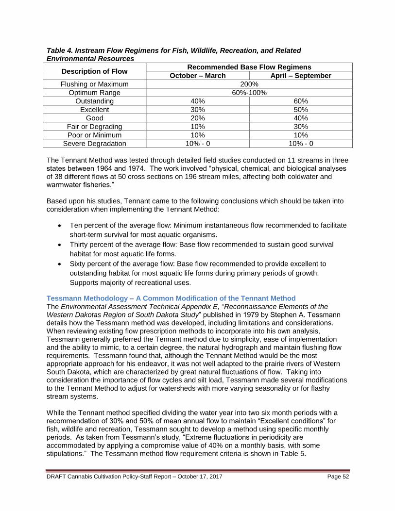
DRAFT Cannabis Cultivation Policy-Staff Report – October 17, 2017 Page 52
Table 4. Instream Flow Regimens for Fish, Wildlife, Recreation, and Related Environmental Resources
Description of Flow Recommended Base Flow Regimens
October – March April – September
Flushing or Maximum 200%
Optimum Range 60%-100%
Outstanding 40% 60%
Excellent 30% 50%
Good 20% 40%
Fair or Degrading 10% 30%
Poor or Minimum 10% 10%
Severe Degradation 10% - 0 10% - 0
The Tennant Method was tested through detailed field studies conducted on 11 streams in three states between 1964 and 1974. The work involved “physical, chemical, and biological analyses of 38 different flows at 50 cross sections on 196 stream miles, affecting both coldwater and warmwater fisheries.” Based upon his studies, Tennant came to the following conclusions which should be taken into consideration when implementing the Tennant Method:
Ten percent of the average flow: Minimum instantaneous flow recommended to facilitate
short-term survival for most aquatic organisms.
Thirty percent of the average flow: Base flow recommended to sustain good survival
habitat for most aquatic life forms.
Sixty percent of the average flow: Base flow recommended to provide excellent to
outstanding habitat for most aquatic life forms during primary periods of growth.
Supports majority of recreational uses.
Tessmann Methodology – A Common Modification of the Tennant Method The Environmental Assessment Technical Appendix E, “Reconnaissance Elements of the Western Dakotas Region of South Dakota Study” published in 1979 by Stephen A. Tessmann details how the Tessmann method was developed, including limitations and considerations. When reviewing existing flow prescription methods to incorporate into his own analysis, Tessmann generally preferred the Tennant method due to simplicity, ease of implementation and the ability to mimic, to a certain degree, the natural hydrograph and maintain flushing flow requirements. Tessmann found that, although the Tennant Method would be the most appropriate approach for his endeavor, it was not well adapted to the prairie rivers of Western South Dakota, which are characterized by great natural fluctuations of flow. Taking into consideration the importance of flow cycles and silt load, Tessmann made several modifications to the Tennant Method to adjust for watersheds with more varying seasonality or for flashy stream systems. While the Tennant method specified dividing the water year into two six month periods with a recommendation of 30% and 50% of mean annual flow to maintain “Excellent conditions” for fish, wildlife and recreation, Tessmann sought to develop a method using specific monthly periods. As taken from Tessmann’s study, “Extreme fluctuations in periodicity are accommodated by applying a compromise value of 40% on a monthly basis, with some stipulations.” The Tessmann method flow requirement criteria is shown in Table 5.

DRAFT Cannabis Cultivation Policy-Staff Report – October 17, 2017 Page 53
Table 5. Tessmann Method Flow Requirements
Situation Minimum Monthly Flow
40% Mean MF > 40% Mean AF 40% Mean MF
Mean MF > 40% Mean AF and 40% Mean MF < 40% mean AF
40% Mean AF
Mean MF < 40% Mean AF Mean MF
*MF = Monthly Flow, AF = Annual Flow
As depicted in Figure 6, the Tessmann method analyzes each individual monthly mean flow and places it in one of three categories (dry, wet or normal) with respect to the mean annual flow. In a “dry month,” the mean monthly flow will be less than 40% of mean annual flow and, therefore, the mean monthly flow will be assigned as the minimum flow requirement. In a “wet month,” mean monthly flow will exceed mean annual flow and, therefore, 40% of the mean monthly flow will be assigned as the minimum flow requirement. If the month is neither “dry” nor “wet,” consider it “normal” and, therefore, 40% of the mean annual flow will be assigned as the minimum flow requirement. See figure below to aid visualization of this concept:
Additionally, Tessmann’s Method prescribes a 14-day period of 200% of mean annual flow during the month of highest runoff for the purpose of flushing the stream’s silt load and flooding streamside habitat.

DRAFT Cannabis Cultivation Policy-Staff Report – October 17, 2017 Page 54
Figure 6. Tessmann Method Flow Requirement Criteria
* Blue bar represents the mean annual flow, light red bar represents the mean monthly flow, and the
dark red bar represents the Tessmann flow requirement. ** MMF = Mean Monthly Flow; MAF = Mean Annual Flow
Flow Model for Estimating Natural Monthly Streamflows in California The majority of established desktop methods use a hydrologic standard setting approach that develops flow requirements based on natural streamflow metrics. The State Water Board applied the Tessmann Method using predicted historical flow data sourced from a flow modeling effort conducted by USGS in cooperation with The Nature Conservancy (TNC) and Trout Unlimited (USGS model). The USGS flow modeling effort developed empirical flow models that predicted the natural (unaffected by land use or water management) monthly streamflows from 1950 to 2012 for the majority of the USGS National Hydrologic Database stream reaches in California (Carlisle 2016). The natural monthly streamflow metrics were used to develop the mean monthly and mean annual flows used in the Tessmann Method.
As described in more detail in the USGS Open-File Report (Carlisle 2016), the concept of the reference-condition was used where a set of reference sites with known gage flow hydrologic record data were used to develop models that were subsequently applied to non-reference sites (such as ungaged stream systems or highly modified systems where hydrologic disturbance is known or suspected). The approach used is based on statistical models of related observed data generally consisting of two types of indicators: static variables that describe watershed features (topography, geology, soils, etc.); and time-series variables, primarily consisting of antecedent precipitation and air temperature.

DRAFT Cannabis Cultivation Policy-Staff Report – October 17, 2017 Page 55
Six different types of statistical models were compared in developing the final model, including five machine-learning models and one multiple linear regression. The random forest machine learning technique proved to perform substantively better than all other modeling approaches. A separate model was developed for each month in each region to predict natural monthly flows for any specific year from 1950 to 2012, resulting in 36 separate sub models. The final data matrix for developing models of natural monthly flows included every year for which each reference site had a measured monthly flow value, the set of weather data and modeled runoff associated with each year’s measured monthly flow plus the previous 12 months, as well as the full set of static physical watershed characteristics.
As summarized in the USGS Open File Report (Carlisle 2016), the “models developed to estimate natural monthly flows performed well and should provide a useful baseline for future studies for how stream flows in California respond to changes in land use, water management, and climate.” The State Water Board evaluated a subset of the final reference gages used to build the natural flow prediction model. For each Cannabis Policy region, the State Water Board evaluated gages that were used both as USGS final reference gages in the modeling effort and as Cannabis Policy compliance gages. The number of gages evaluated for each region is shown in Table 6. Table 6. Number of Reference Gages used in USGS Model and Cannabis Policy Compliance Gages by Region*
Region Number of Gages
Klamath 7
Upper Sacramento 0
N. East Desert 0
North Coast 9
Middle Sacramento 0
Southern Sacramento 2
N. Central Coast 4
Tahoe 4
S. Central Coast 12
San Joaquin 7
Mono 1
Kern 3
South Coast 7
S. Eastern Desert 5
* The State Water Board selected the four gages with the longest period of no hydrologic alteration in each region for analysis, or all of the gages in regions with less than four overlapping gages.

DRAFT Cannabis Cultivation Policy-Staff Report – October 17, 2017 Page 56
Up to four reference/compliance gages were selected for each region and the USGS monthly mean historical record for each gage was downloaded from the USGS website for each gage and imported into a spreadsheet for comparison with the outputs in the USGS streamflow dataset. An index/match function of observed over expected (O/E), or the observed historical gage data over the expected or predicted USGS streamflow dataset, was analyzed for six factors for each gage. The six factors analyzed were the mean flow values for November, December, January, February, March, and mean annual flow. The flow data was averaged over the entire period of record for which there was minimal or no hydrologic alteration. In addition to O/E values, percent difference values were calculated by subtracting the expected value from the observed value and dividing the difference by the expected value to provide a percent inflation or deflation in the model predictions relative to the historical gage record. Table 7 displays the percent accuracy of the gages used in the analysis by region. In general, based on this specific sample size, the average statewide reference gage record was 3.6 percent higher than what the model predicted statewide for the same period (+3.6 percent). This means that the USGS flow dataset, on average, predicted 3.6 percent more mean flow than the mean flow recorded at the reference gages. The Upper Sacramento, North East Desert, and Middle Sacramento Regions did not have any gages that overlapped between the USGS reference gages and the State Water Board’s Cannabis Policy compliance gages and therefore data are not available to analyze percent error or O/E values for these regions. On average, the selected gages in the Klamath, North Coast, Southern Sacramento, North Central Coast, Tahoe, South Central Coast, San Joaquin, and Mono Regions ranged from 3.1 percent below (-3.1 percent) to 5.3 percent above (+5.3 percent) predicted values, while gages within the Kern, South Coast, and South Eastern Desert Regions averaged respectively 12.4 percent (+12.4 percent), 10.9 percent (+10.9 percent), and 13.4 percent (+13.4 percent) above predicted values. The mean annual flow for the Kern, South Coast, and South Eastern Desert Regions were predicted more accurately than the mean monthly flows, indicating that overall total annual runoff was relatively more accurate than monthly predictions. This may be an indication that the USGS natural flow prediction model did not predict timing of the surface water to groundwater interactions of the dry desert areas as well as other regions of the state. As described on page 8 in the USGS Open File Report, “Model performance was marginally higher in both mountainous regions than in the xeric region” (Carlisle 2016). Please refer to this report for further details on the model’s use of surrogate variables as predictors for groundwater contributions to streamflow and other model performance metrics. Zimmerman et. al. (2017) notes in their analysis of the USGS flow dataset that “these results indicate that arid basins are underrepresented in the stream gaging network of California, and that our flow predictions for the NHD network in arid areas should be interpreted with caution. Nevertheless, given the low likelihood that additional stream gages will be installed in arid areas, our predictions represent the best available estimates of natural flows for the time being.” The State Water Board will consider the relative accuracies of these monthly and annual USGS streamflow dataset statistics when implementing the Cannabis Policy Numeric Instream Flow Requirements, with a focus on the Kern, South Coast, and South Eastern Desert Regions. The State Water Board will also monitor the number of surface water diversions and consider stakeholder input in these regions to reevaluate whether the flow requirements should be adjusted to reflect the percent difference in O/E. If stakeholders believe the Numeric Instream Flow Requirement is over protective or under protective in their localized area they can develop a local natural or unimpaired flow model or conduct a local instream flow study and submit it to the State Water Board for consideration in the next update to the Cannabis Policy.

DRAFT Cannabis Cultivation Policy-Staff Report – October 17, 2017 Page 57
Table7. Percent Accuracy of Model Predictions Relative to Historical Gage Record of Select Gages in each Region
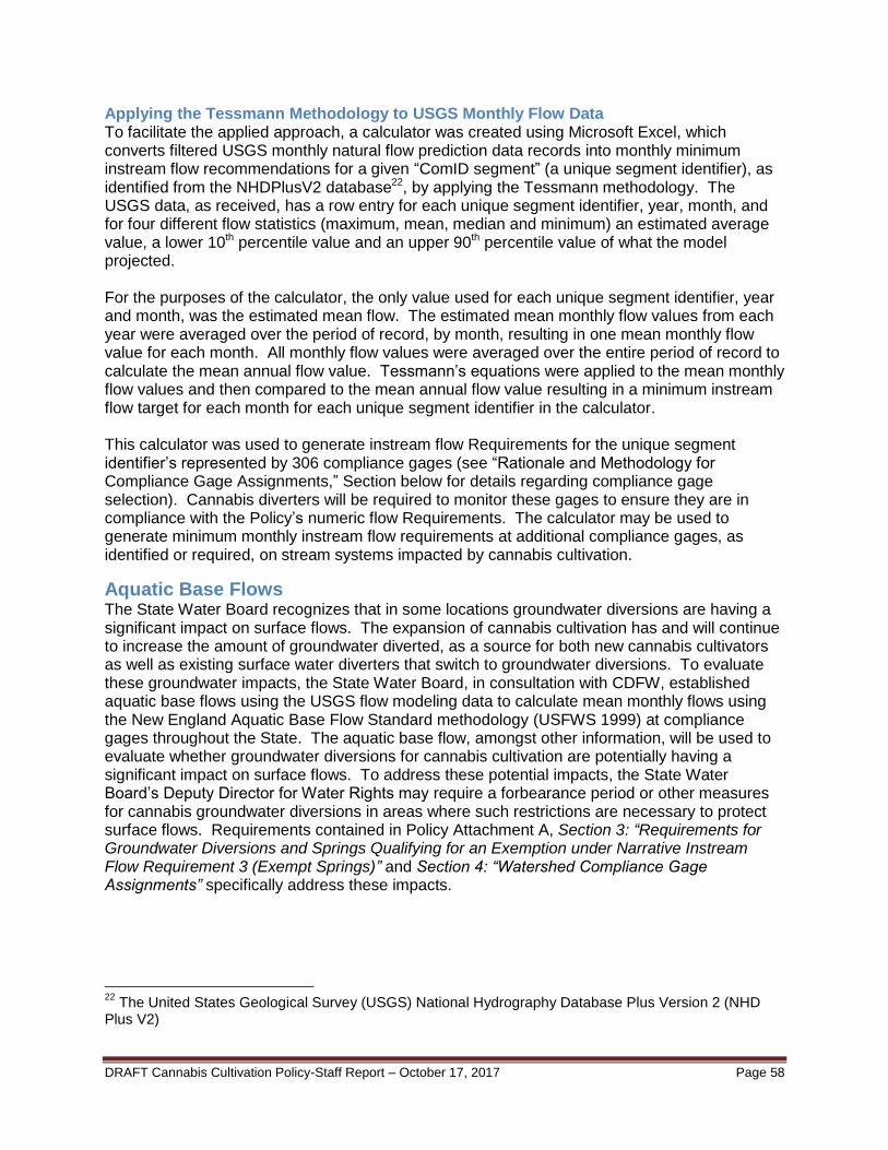
DRAFT Cannabis Cultivation Policy-Staff Report – October 17, 2017 Page 58
Applying the Tessmann Methodology to USGS Monthly Flow Data To facilitate the applied approach, a calculator was created using Microsoft Excel, which converts filtered USGS monthly natural flow prediction data records into monthly minimum instream flow recommendations for a given “ComID segment” (a unique segment identifier), as identified from the NHDPlusV2 database22, by applying the Tessmann methodology. The USGS data, as received, has a row entry for each unique segment identifier, year, month, and for four different flow statistics (maximum, mean, median and minimum) an estimated average value, a lower 10th percentile value and an upper 90th percentile value of what the model projected. For the purposes of the calculator, the only value used for each unique segment identifier, year and month, was the estimated mean flow. The estimated mean monthly flow values from each year were averaged over the period of record, by month, resulting in one mean monthly flow value for each month. All monthly flow values were averaged over the entire period of record to calculate the mean annual flow value. Tessmann’s equations were applied to the mean monthly flow values and then compared to the mean annual flow value resulting in a minimum instream flow target for each month for each unique segment identifier in the calculator. This calculator was used to generate instream flow Requirements for the unique segment identifier’s represented by 306 compliance gages (see “Rationale and Methodology for Compliance Gage Assignments,” Section below for details regarding compliance gage selection). Cannabis diverters will be required to monitor these gages to ensure they are in compliance with the Policy’s numeric flow Requirements. The calculator may be used to generate minimum monthly instream flow requirements at additional compliance gages, as identified or required, on stream systems impacted by cannabis cultivation.
Aquatic Base Flows The State Water Board recognizes that in some locations groundwater diversions are having a significant impact on surface flows. The expansion of cannabis cultivation has and will continue to increase the amount of groundwater diverted, as a source for both new cannabis cultivators as well as existing surface water diverters that switch to groundwater diversions. To evaluate these groundwater impacts, the State Water Board, in consultation with CDFW, established aquatic base flows using the USGS flow modeling data to calculate mean monthly flows using the New England Aquatic Base Flow Standard methodology (USFWS 1999) at compliance gages throughout the State. The aquatic base flow, amongst other information, will be used to evaluate whether groundwater diversions for cannabis cultivation are potentially having a significant impact on surface flows. To address these potential impacts, the State Water Board’s Deputy Director for Water Rights may require a forbearance period or other measures for cannabis groundwater diversions in areas where such restrictions are necessary to protect surface flows. Requirements contained in Policy Attachment A, Section 3: “Requirements for Groundwater Diversions and Springs Qualifying for an Exemption under Narrative Instream Flow Requirement 3 (Exempt Springs)” and Section 4: “Watershed Compliance Gage Assignments” specifically address these impacts.
22
The United States Geological Survey (USGS) National Hydrography Database Plus Version 2 (NHD Plus V2)

DRAFT Cannabis Cultivation Policy-Staff Report – October 17, 2017 Page 59
Methodology for Development of Dry Season Aquatic Base Flow Values The New England Aquatic Base Flow (ABF) Standard was developed in 1981 and implemented as an internal United States Fish and Wildlife Service (USFWS) directive that establishes standard procedures for USFWS personnel when reviewing water development projects in New England. (USFWS 1999) The USFWS directive uses a bifurcated approach to developing instream flow recommendations. A choice must be made between using the ABF Standard versus site-specific studies such as the Instream Flow Incremental Method (IFIM). Complex circumstances often necessitate site-specific studies. However, the ABF Standard is implemented in situation when: a project is relatively straightforward; the waters are not over-allocated to uses such as water supply, hydropower or irrigation; a single flow recommendation is sufficient; the administrative process is straightforward; time and cost constraints are significant issues; or a goal of the parties involved is to minimize risk and provide certainty during the regulatory process.
The ABF Standard is applied in one of two ways, depending on whether the stream system in question meets certain criteria. In general, the criteria include a minimum size drainage area of 50 square miles, a period of record for each stream gaging station of at least 25 years, gaging records of good-to-excellent quality, a basically free flowing or unregulated stream, and median monthly flow values calculated by taking the median of monthly average flows for the period of record. If these requirements are not met, a default flow is selected as the flow requirement. A default flow is simply a generic flow criterion applicable to a stream that does not meet the minimum ABF criteria (e.g., 25 years of records, etc.) as discussed previously. The default flows are developed from the flow statistics from 48 stream gages in New England. If hydrologic statistics are unavailable, or other criteria are not met, default values for April/May, August and February are assumed to be 4.0, 0.5 and 1.0 cubic feet per second per square mile of drainage. These ABF default flows are based on New England hydrology (developed statistically in the Connecticut River basin on a reach level), however, and should not be blindly used in other regions, such as those in California.
The State Water Board has determined that the ABF Standard of selecting the median of mean monthly flows is appropriate for setting a dry season aquatic base flow for each compliance gage location. While a 25 year historical gage record of actual flows is not available at all gage locations, the State Water Board has chosen to use the USGS mean natural monthly streamflow predictions over the 65 year period observed in the dataset for the ABF calculations. Median monthly flow values were calculated by taking the median of predicted natural monthly mean flow. The ABF Standard, as developed for the New England region, uses the limiting factors concept to identify critical life cycle functions, temporal periods, and chemical and physical parameters that could function as limiting factors on aquatic life. Low flow conditions in August typically represent a natural limiting period because of high stream temperatures and diminished living space, dissolved oxygen and food supply. The median flow for August was therefore designated as the ABF. Some applications in the southeastern United States have calculated the ABF using September rather than August median flow, since September was the month with the lowest median flow in those regions.

DRAFT Cannabis Cultivation Policy-Staff Report – October 17, 2017 Page 60
A review of the mean monthly flow statistics for the gages in which the aquatic base flow Requirements will be implemented indicate that the month of September is often the lowest flowing month for locations with median flows greater than 1.0 cubic feet per second (cfs), accounting for approximately 41 percent of the dataset. The second most frequently occurring lowest flow month is August, at 16 percent, followed by October at 15 percent. The remaining 28 percent of occurrences were in April, May, June, and July combined. California has vast diversity in its hydrology throughout the state and strictly applying the August median flow as an ABF threshold would not meet the intent of the original New England ABF policy. The aquatic base flow for each compliance gage is calculated based on the mean monthly flow of the lowest flowing month from April through October to account for the varying hydrology throughout California. In general, in California, the lowest flows and highest temperatures occur during August, September, and October. However, a relatively small subset of streams represented by the Cannabis Policy compliance gages stop flowing or nearly stop flowing (less than 1.0 cfs) during the dry season based on predicted historical modeling. To address these intermittent stream systems that are predicted to reach zero or near zero flows during the dry season, the aquatic base flow is calculated by taking the median of the mean monthly flow (over the predicted historical modeling period) of the lowest non-zero flow month that is greater than 1.0 cfs. In the case that the stream does not have a predicted median of the mean monthly flow greater than 1.0 cfs during the dry season (April through October), the groundwater aquatic base flow will default to 1.0 cfs for that stream. While the ABF Standard is traditionally applied to watershed drainage areas greater than 50 square miles, the State Water Board applied to ABF Standard throughout California, including watershed drainage areas of less than 50 square miles. Requirements contained in Policy Attachment A, Section 3: “Requirements for Groundwater Diversions and Springs Qualifying for an Exemption under Narrative Instream Flow Requirement 3 (Exempt Springs)” and Section 4: “Watershed Compliance Gage Assignments” specifically address these impacts.
RATIONALE AND METHODOLOGY FOR COMPLIANCE GAGE
ASSIGNMENTS
Identifying Appropriate Compliance Gages Compliance with the numeric instream flow Requirements identified in the Policy is based on hydrology at selected gages chosen to represent watersheds throughout California. To determine which existing gages could serve as compliance gages, State Water Board staff reviewed active gage networks in California. Numerous federal, state and local agencies, and nongovernmental organizations (NGOs) operate streamflow gages in California with varying levels of data availability, reporting frequency, and data quality control. Due to time limitations, only the gages that meet the following criteria were selected for use:
1. operated by the USGS, Army Corps, United States Bureau of Reclamation (USBR) or the California Department of Water Resources (DWR); and
2. reported on the National Water Information System (NWIS) or DWR-California Data Exchange Center (CDEC) websites.
This selection was made due to the availability of documentation related to data quality control and the broad confidence that can be placed in these datasets.

DRAFT Cannabis Cultivation Policy-Staff Report – October 17, 2017 Page 61
Once the gage networks and data sources were selected, a list of the active gages was created. The NWIS website23 was queried on March 19, 2016 for Location=California, Site Type= Stream, Parameters= Streamflow, ft³/s and returned approximately 587 gages operated by the USGS. A similar query of the CDEC24 on August 18, 2016, for Status=Active, and Sensor Type= Flow, Full Natural; Full Natural Flow; Flow, River Discharge; Flow, River Discharge Precise, Flow, Mean Discharge returned approximately 379 gages. After removing duplicates and gages operated by local agencies or NGO’s, a list of 717 gages was created for further investigation. The active gage names were manually reviewed, and any gage with the term “canal,” “spillway,” “diversion,” or similar terms were categorized as an “Excluded Gage,” that do not provide information on natural streamflow. All remaining gages were categorized as “Potential Compliance Points” and subjected to additional review. Each of the remaining gages was evaluated for use as a compliance gage based on the location and stream flow data collected. Based on this evaluation, the gages were placed into three main categories: compliance gage, compliance gage downstream of a dam, or excluded gage. Gages were excluded if they were not active, were slated for de-activation, did not report discharge, did not measure streamflow, or were heavily impacted by anthropogenic actions. The compliance gages were then subdivided into “reference” and “non-reference” sites, based on data provided by the University of California at Davis, which identified sites with little to no upstream impacts as “reference gages.” Numeric flow Requirements using the Tessmann Method were developed at each gage that was categorized as either a compliance gage or a compliance gage downstream of a dam. The gages were then plotted in GIS along with the USGS National Hydrography Dataset (NHD) [NHDPlusV2] and the USGS Watershed Boundary Dataset (WBD). Using the WBD at the levels of Hydrologic Unit Code (HUC) -8, HUC-10 and HUC-12, a shapefile was created for each potential compliance gage, and included all HUC-12 level areas represented by the measurements at the gage. If a gage was located at the downstream end of a HUC-12, that HUC-12 area and all upstream contributing HUC-12s were included in the shapefile. Professional judgement was used to include or exclude a HUC-12 area if the gage was located in the middle or upper area of the HUC, indicating that all areas of that HUC-12 were not well represented in the flow measured at the gage. The remaining upstream contributing HUC-12 areas were then used in the shapefile, which was named with the Gage ID. During the drainage area mapping exercise, if a major reservoir, rim dam, water transfer or other flow regulating feature was observed which would impact flows at downstream gages, those gages were re-categorized as “Excluded Gage” and their drainage areas were not mapped. Once the drainage area was mapped for each potential compliance gage, a more detailed assessment of each gage was conducted. As a first step, State Water Board staff retrieved the direct weblink for each gage and determined whether the gage was active, the type of sensor or information that was available, and the reporting frequency of the data. This data were then attributed to the project shapefile.
23
http://waterdata.usgs.gov/nwis/dv/?referred_module=sw 24
http://cdec.water.ca.gov/cgi-progs/staSearch
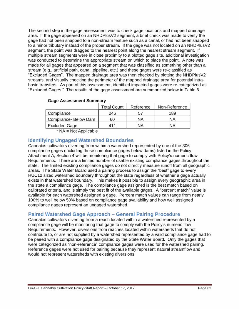
DRAFT Cannabis Cultivation Policy-Staff Report – October 17, 2017 Page 62
The second step in the gage assessment was to check gage locations and mapped drainage area. If the gage appeared on an NHDPlusV2 segment, a brief check was made to verify the gage had not been snapped to a non-stream feature such as a canal, or had not been snapped to a minor tributary instead of the proper stream. If the gage was not located on an NHDPlusV2 segment, the point was dragged to the nearest point along the nearest stream segment. If multiple stream segments were in close proximity to a plotted gage site, additional investigation was conducted to determine the appropriate stream on which to place the point. A note was made for all gages that appeared on a segment that was classified as something other than a stream (e.g., artificial path, canal, pipeline, etc.) and these gages were re-classified as “Excluded Gages”. The mapped drainage area was then checked by plotting the NHDPlusV2 streams, and visually checking the perimeter of the mapped drainage area for potential intra-basin transfers. As part of this assessment, identified impacted gages were re-categorized as “Excluded Gages.” The results of the gage assessment are summarized below in Table 6.
Gage Assessment Summary
Total Count Reference Non-Reference
Compliance 246 57 189
Compliance- Below Dam 60 NA NA
Excluded Gage 411 NA NA
* NA = Not Applicable
Identifying Ungaged Watershed Boundaries Cannabis cultivators diverting from within a watershed represented by one of the 306 compliance gages (including those compliance gages below dams) listed in the Policy, Attachment A, Section 4 will be monitoring that gage to comply with Policy’s numeric flow Requirements. There are a limited number of usable existing compliance gages throughout the state. The limited existing compliance gages do not directly measure runoff from all geographic areas. The State Water Board used a pairing process to assign the “best” gage to every HUC12 sized watershed boundary throughout the state regardless of whether a gage actually exists in that watershed boundary. This makes it possible to assign every geographic area in the state a compliance gage. The compliance gage assigned is the best match based on calibrated criteria, and is simply the best fit of the available gages. A “percent match” value is available for each watershed assigned a gage. Percent match values can range from nearly 100% to well below 50% based on compliance gage availability and how well assigned compliance gages represent an ungaged watershed.
Paired Watershed Gage Approach – General Pairing Procedure Cannabis cultivators diverting from a reach located within a watershed represented by a compliance gage will be monitoring that gage to comply with the Policy’s numeric flow Requirements. However, diversions from reaches located within watersheds that do not contribute to, or are not supplied by a watershed represented by a valid compliance gage had to be paired with a compliance gage designated by the State Water Board. Only the gages that were categorized as “non-reference” compliance gages were used for the watershed pairing. Reference gages were not used for pairing because they represent natural streamflow and would not represent watersheds with existing diversions.

DRAFT Cannabis Cultivation Policy-Staff Report – October 17, 2017 Page 63
The pairing procedure is based on dividing the state into HUC12 sized watershed boundaries and then matching the “best” compliance gage to every HUC12 watershed throughout the state. A python script run in ArcGIS was used to select the highest flowing NHDPlusV2 stream segment by COMID to hydrologically represent its corresponding HUC12. Only stream segments that had predicted natural flow values from the USGS model (Carlisle 2016) were used in this selection process. HUC12’s that did not have stream segments with predicted natural flow values from the USGS model were paired using the same procedure, excluding the hydrograph comparison. Once a NHDPlusV2 stream segment was selected to represent each HUC12, the general pairing procedure paired watersheds based on a set of weighted criteria to best correlate an ungaged watershed to one with a designated compliance gage. The most critical factor in correlating watershed compliance gages is the timing of the onset and subsequent diminishment of peak flow periods during the wet season of a given stream system.
Four factors were evaluated in the watershed pairing procedure: hydrograph, proximity, drainage area, and the difference of the HUC12 numbering convention as follows:
Hydrograph - Using available data from the USGS model (Carlisle 2016), the normalized annual hydrograph (mean monthly predicted flow, normalized by mean annual flow, plotted over time) was generated for each gage station and each ungaged watershed. The sum of the absolute differences in mean monthly flows was calculated and converted to a percentage, providing a way to identify the confidence level of the correlation strength between flow duration and timing in watersheds.
Proximity - The geographic coordinates of the centroid of each watershed boundary area were determined using GIS software, thus allowing calculation of the average estimated distance between each watershed. The assumption is that geographically proximate watersheds will share relatively more similar geological and climatic attributes, resulting in generally stronger hydraulic and hydrologic correlations.
Drainage Area - The ratio of the two watershed surface areas was calculated. The assumption is that watersheds with more similar surface areas will have relatively more similar runoff response times, among other hydraulic and hydrologic correlations.
Difference of the HUC12 Numbering Convention – The difference of the HUC12 number of the watershed containing the compliance gage and the HUC12 number of the watershed to be paired to a gage was taken (HUC12 differential). If the gage falls within the same HUC10, 8, or larger watershed as the watershed to be paired versus a gage that falls in a different HUC10, 8, or larger watershed, the gage in the same HUC10, 8, or larger watershed will correlate stronger in the pairing procedure.
Each of the four criteria were converted to a modifier between 0 and 1, with 1 being a theoretical perfect match and 0 being a theoretical non-match. For every potential match between an ungaged watershed and a compliance gage, all three modifiers were calculated, raised to a fractional exponent as a means of providing calibration, and then each modifier was collectively multiplied together to result in one final overall matching factor between 0 and 1. Of the resulting calculations, the pair with a matching factor closest to 1 represents the best available match between watershed and compliance gage.

DRAFT Cannabis Cultivation Policy-Staff Report – October 17, 2017 Page 64
To effectively select the best match, the most important matching criteria must be calibrated to have a heavier overall weighting than the others. For this analysis, the highest priority was placed on the hydrograph match, followed by proximity (shortest distance between watersheds), followed by drainage area (smallest difference in size), and finally, the HUC12 differential (smallest difference). After each modifier was converted to a fraction between 0 and 1, fractional exponents were used to force the value of each fractional modifier closer to 1, to provide a way of calibrating a specific modifier’s relative impact on the overall matching factor once all three modifiers are multiplied together. An exponent was chosen, as opposed to a fractional multiplier, in an effort to force the poorer matches to have a greater impact on lowering the overall correlation score. While the range for each matching factor varies depending on each comparison analyzed, the matching factor for the hydrograph was weighted up to 232 percent heavier than proximity/distance, which was weighted up to 143 percent heavier than the drainage area comparison. State Water Board staff arrived at these weighting factors based on several iterations of running the matches and manually analyzing results for proper matching. These weighting factors can be adjusted in the future, if necessary.
Gage Assignment Maps The following maps provide a general depiction of compliance gage assignments in Cannabis Policy Regions and are included for illustrative purposes. Actual gage assignments identified by following the procedure described in Attachment A, Section 4 of the Policy will be available on a State Water Board designated website.

DRAFT Cannabis Cultivation Policy-Staff Report – October 17, 2017 Page 65
DRAFT Cannabis Cultivation Policy-Staff Report – October 17, 2017 Page 66

DRAFT Cannabis Cultivation Policy-Staff Report – October 17, 2017 Page 67

DRAFT Cannabis Cultivation Policy-Staff Report – October 17, 2017 Page 68

DRAFT Cannabis Cultivation Policy-Staff Report – October 17, 2017 Page 69

DRAFT Cannabis Cultivation Policy-Staff Report – October 17, 2017 Page 70

DRAFT Cannabis Cultivation Policy-Staff Report – October 17, 2017 Page 71

DRAFT Cannabis Cultivation Policy-Staff Report – October 17, 2017 Page 72

DRAFT Cannabis Cultivation Policy-Staff Report – October 17, 2017 Page 73

DRAFT Cannabis Cultivation Policy-Staff Report – October 17, 2017 Page 74
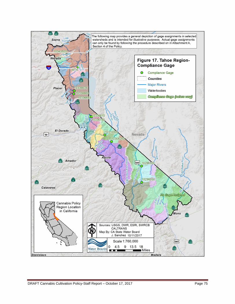
DRAFT Cannabis Cultivation Policy-Staff Report – October 17, 2017 Page 75

DRAFT Cannabis Cultivation Policy-Staff Report – October 17, 2017 Page 76
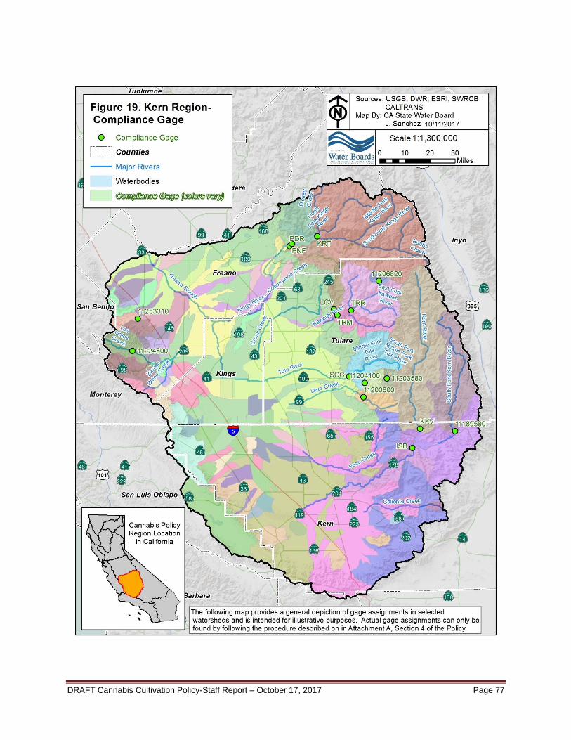
DRAFT Cannabis Cultivation Policy-Staff Report – October 17, 2017 Page 77

DRAFT Cannabis Cultivation Policy-Staff Report – October 17, 2017 Page 78

DRAFT Cannabis Cultivation Policy-Staff Report – October 17, 2017 Page 79
WATER QUALITY ANTIDEGRADATION ANALYSIS
State Water Board Resolution No. 68-16, the Statement of Policy with Respect to Maintaining High Quality of Waters in California (the Antidegradation Policy), requires that the discharge of waste to the waters of the state be regulated to achieve the highest water quality consistent with the maximum benefit to the people of the state. The quality of some waters is higher than established by adopted policies and that higher quality water must be maintained to the maximum extent possible consistent with the Antidegradation Policy. The Antidegradation Policy requires the following:
Whenever the quality of water is better than the quality established in policies as of the date on which such policies become effective, such high quality will be maintained until it has been demonstrated to the State that any change will be consistent with maximum benefit to the people of the State, will not unreasonably affect present and anticipated beneficial use of such water, and will not result in water quality less than that prescribed in the policies.
Any activity which produces or may produce a waste or increased volume or concentration of waste and which discharges or proposes to discharge to high quality waters will be required to meet waste discharge requirements which will result in the best practicable treatment or control of the discharge necessary to assure that (a) a pollution or nuisance will not occur, and (b) the highest water quality consistent with maximum benefit to the people of the State will be maintained.
To obtain coverage under the Cannabis General Order, cannabis cultivators must self-certify that all applicable Requirements have been, or will be implemented by the onset of the winter period following the enrollment date. Those cannabis cultivators that cannot implement all applicable Requirements by onset of the winter period, must submit a proposed time schedule and scope of work to the Regional Water Board for use in preparing a time schedule order. Interim Requirements must also be implemented to prevent unseasonable precipitation events from resulting in discharges of waste constituents. Interim Requirements are those that can be implemented immediately following site development. Furthermore, to avoid water quality degradation from erosion and sedimentation, construction and grading activities must not occur during the winter period, as defined in the Policy. Emergency construction and site grading activities are subject to authorization by the applicable Regional Water Board Executive Officer or designee on a site specific basis. The Regional Water Board Executive Officer may require a separate work plan, compliance schedule, and require that all work is supervised a Qualified Professional, as defined in the Policy.
Although background water quality varies significantly in those areas covered by the Policy, most receiving waters are considered high quality waters for one or more constituent of concern. The Requirements of the Policy represent the best practicable treatment or control of discharges from cannabis cultivation sites. To the extent a discharge may be to high quality waters, the Policy authorizes limited degradation consistent with the Antidegradation Policy.
State taxes will be imposed on growing and selling cannabis beginning January 1, 2018. In addition, local governments are authorized to add additional local taxes. The annual state and local tax revenue is forecast to be approximately $1 billion. The revenue will address social, legal, and environmental issues related to cannabis. (LAO 2016)
DRAFT Cannabis Cultivation Policy-Staff Report – October 17, 2017 Page 80
Limited degradation of groundwater by some waste constituents associated with discharges from cannabis cultivation activities, after effective Requirements are implemented, is consistent with the maximum benefit to the people of the state. The economic benefit described above and the need to provide a safe supply of cannabis is of maximum benefit to the people of the state and provides sufficient justification for allowing limited water quality degradation that may occur pursuant to the Policy, Cannabis General Order, and Cannabis General Water Quality Certification provided the terms of the applicable water quality control plans (commonly referred to as Basin Plans), and other applicable policies and plans of the Water Boards are consistently met. The State Water Board anticipates most cannabis cultivation canopy areas (as defined by CDFA) will be less than one acre. Because most cannabis cultivation sites will be relatively small, they are inherently less of a threat to water quality. However, cumulative impacts from a regional concentration of small cultivation sites may result in significant water quality impacts if applicable Requirements are not implemented. All cannabis cultivators must certify that they are in compliance with Requirements (or a Regional Water Board compliance schedule) associated with their cannabis cultivation site tier ranking. Cannabis cultivators that are not in compliance with the Policy are subject to enforcement actions, including imposition of administrative civil liabilities.
All cannabis cultivators must comply with the minimum riparian setback Requirements in the Policy. High risk sites (any portion of the disturbed area is located within the riparian setback Requirements), with the exception of activities authorized under 404/401 CWA permits, a CDFW LSA Agreement, coverage under the Cannabis General Order water quality certification or grandfathered sites provision, or site-specific WDRs issued by the Regional Water Board, will be assessed the high-risk fee until the activities comply with the riparian setback Requirements. It is the cannabis cultivator’s responsibility to notify the Regional Water Board of compliance with the riparian setback Requirements to reassess the annual fee. If the site is unable to meet the compliance schedule contained in the Cannabis General Order for complying with the riparian setback Requirements, the Regional Water Board may issue a site-specific enforcement order and compliance schedule.
Water Code section 13276 identifies 12 types of waste discharge that may result from cannabis cultivation. The 12 types can be grouped according to type of discharge and are described below.
a. Discharges of sediment from roads, improperly constructed or maintained stream crossings, drainage culverts, disturbed areas, or cultivation sites to surface water. Discharges of sediment can be controlled through compliance with Policy Requirements.
b. Discharges resulting from development within and adjacent to wetlands and riparian zones. Discharges to wetlands and riparian zones can be controlled through compliance with Policy Requirements.
c. Discharges of fertilizers, pesticides (including herbicides and rodenticides) to surface water or groundwater. Discharges of the chemicals described can be controlled through compliance with Policy Requirements.
d. Spills or leaks of fuels, lubricants, hydraulic oil, or other chemical associated with pumps, construction, or other equipment. Discharges of these waste materials can be controlled through compliance with Policy Requirements.

DRAFT Cannabis Cultivation Policy-Staff Report – October 17, 2017 Page 81
e. Discharges of trash, household refuse, or domestic wastewater. Discharges of these waste materials can be controlled through compliance with Policy Requirements.
Cannabis cultivators enrolled in the Cannabis General Order must submit a Site Management Plan that describes how they are complying with Policy Requirements.
See information presented in the previous sections (“Constituents of Concern” and “Slope and Erosion Potential Relationship”) under the broader Background and Rationale for Requirements to Address Water Diversion and Waste Discharge Associated with Cannabis Cultivation section of the Staff Report for further information supporting this Antidegradation Analysis.
Compliance with the Policy and any water quality related mitigation measures in other current, future, and/or location-specific California Environmental Quality Act (CEQA) documents addressing cannabis cultivation and associated activities will ensure compliance with the applicable water quality control plans.
Cannabis cultivators that want to terminate coverage under the Cannabis General Order must submit a Notice of Termination (NOT). The NOT must include a Site Closure Report (described in Policy Attachment A, Section 5: Permitting and Reporting “) and a final monitoring report. The Regional Water Board reserves the right to inspect the site before approving an NOT.
Cannabis Cultivation Policy-Staff Report – October 17, 2017 Page 82
REFERENCES Bauer, S., Olson, J., Cockrill, A., van Hattem, M., Miller L., Tauzer M., and Leppig, G. 2015.
Impacts of Surface Water Diversions for Marijuana Cultivation on Aquatic Habitat in Four Northwestern California Watersheds. PLoS ONE 10(3): e0120016. Available at:
https://doi.org/10.1371/journal.pone.0120016 Bentrup, G. and Hoag, J.C. 1998. The Practical Streambank Bioengineering Guide. United
States Department of Agriculture, Interagency Riparian/Wetland Plant Development Project. Available at: http://www.nrcs.usda.gov/Internet/FSE_PLANTfMATERIALS/publications/idpmcpu116.pdf
Brown and Caldwell, Kennedy/Jenks Consultants. 2007. Manual of Good Practice of Land
Application of Food Processing/Rinse Water. California League of Food Processors. Available at: http://clfp.com/documents/Manualofgoodpractice/CLFP%20Manual_COMPLETE_FINAL_3-14-07%20(2).pdf
Cafferata, P. 2015. California Road Rules for 2015 and Beyond. Associated California Loggers
Annual Meeting January 15, 2015. California Department of Forestry and Fire Protection. Available at: http://www.fire.ca.gov/resource_mgt/downloads/Cafferata_RoadRules2013_ACL-talk_January2015(final).pdf. Accessed May 4, 2017.
California Department of Fish and Wildlife (CDFW). 2017a. Fish Species of Special Concern.
Available at: https://www.wildlife.ca.gov/Conservation/SSC/Fishes. Accessed March 15, 2017.
CDFW. 2017b. State & Federally Listed Endangered & Threatened Animals of California.
Available at: https://nrm.dfg.ca.gov/FileHandler.ashx?DocumentID=109405&inline. Accessed January 23, 2017.
CDFW. 2015. California State Wildlife Action Plan, 2015 Update: A Conservation Legacy for
Californians. Edited by Armand G. Gonzales and Junko Hoshi, PhD. Prepared with assistance from Ascent Environmental, Inc., Sacramento, CA.
California Department of Fish & Game (CDFG). 2003. Atlas of the biodiversity of California.
Sacramento, CA. 103. pp. Available at: https://nrm.dfg.ca.gov/FileHandler.ashx?DocumentID=116547. Accessed March 10, 2017.
CDFG. 2002. California climate based on the Köppen Classification System. GIS coverage.
Wildlife and Habitat Data Analysis Branch. Sacramento, CA. California Department of Food and Agriculture (CDFA). 2016. Licensing Survey Results.
Available at: https://static.cdfa.ca.gov/MCCP/document/2016%20Licensing%20Survey%20Results.pdf. Viewed 27 December 2016.
Cannabis Cultivation Policy-Staff Report – October 17, 2017 Page 83
California Department of Transportation (Caltrans). 2017. Construction Site BMP Fact Sheets. Division of Construction. Sacramento, CA. Available at: http://www.dot.ca.gov/hq/construc/stormwater/factsheets.htm
Caltrans. 2003. Solid Waste Management, Construction Site Best Management Practices
Manual. Available at: http://www.dot.ca.gov/hq/construc/stormwater/WM-05.pdf California Department of Water Resources (DWR). 2013. Division of Safety of Dams Jurisdiction
Over Dams and Reservoirs. Division of Safety of Dams. Sacramento, CA. Available at: http://www.water.ca.gov/damsafety/jurischart/
California Geologic Survey (CGS). 2002. Map of California Geomorphic Provinces, Note 36.
California Department of Conservation, California Geological Survey. Sacramento, CA. Available at: http://www.conservation.ca.gov/cgs/information/publications/cgs_notes/note_36/Documents/note_36.pdf. Accessed March 10, 2017.
California Plant Health Association (CPHA). 1980. Western Fertilizer Handbook Sixth Edition. Soil Improvement Committee. California Regional Water Quality Control Board, Central Coast Region. 2016. “Water Quality
Control Plan for the Central Coastal Basin”. Available at http://www.waterboards.ca.gov/centralcoast/publications_forms/publications/basin_plan/index.shtml.
California Regional Water Quality Control Board, Central Valley Region. 2016. “Water Quality
Control Plan for the California Regional Water Quality Control Board Central Valley Region”. Available at http://www.waterboards.ca.gov/centralvalley/water_issues/basin_plans/index.shtml.
California Regional Water Quality Control Board, North Coast Region. 2011. “Water Quality
Control Plan for the North Coast Region”. Available at http://www.waterboards.ca.gov/northcoast/water_issues/programs/basin_plan/basin_plan.shtml.
California Storm Water Quality Association. 2003. Section 4: Source Control BMPs and
California Stormwater BMP Handbook. Available at: https://www.casqa.org/sites/default/files/BMPHandbooks/sd-12.pdf and https://www.casqa.org/sites/default/files/BMPHandbooks/sd-32.pdf
Carlisle, D.M., Wolock, D.M., Howard, J.K., Grantham, T.E., Fesenmyer, K., and Wieczorek, M.
2016. Estimating natural monthly streamflows in California and the likelihood of anthropogenic modification: U.S. Geological Survey Open-File Report 2016–1189, 27 p., Available at: https://doi.org/10.3133/ofr20161189.
Cobourn, J. 2011. How to Install Residential Scale Best Management Practices (BMPs) in the
Lake Tahoe Basin. University of Nevada Cooperative Extension. Available at: http://www.tahoebmp.org/Documents/Contractors%20BMP%20Manual.pdf
Critchfield, H. J. 1983. General Climatology, 4th Ed. Englewood Cliffs: Prentice Hall.
Cannabis Cultivation Policy-Staff Report – October 17, 2017 Page 84
Crozier, C. 1986. Soil Conservation Techniques for Hillside Farms, A Guide for Peace Corps Volunteers. Peace Corps Information Collection and Exchange Reprint Series No.R-62. November 1986. Available at: http://files.eric.ed.gov/fulltext/ED288044.pdf.
Five Counties. 2002. A Water Quality and Stream Habitat Protection Manual for County Road
Maintenance in Northwestern California Watersheds. Five Counties Salmon Conservation Program. Available at: http://www.5counties.org/roadmanual.htm.
Forrest, C. and Young, J.P. 2006. The Effects of Organic and Inorganic Nitrogen Fertilizer on
the Morphology and Anatomy of Cannabis sativa “Fédrina” (Industrial Fibre Hemp) Grown in Northern British Columbia, Canada. Journal of Industrial Hemp Vol. 11, Iss.2, 2006.
Freeze, A. and Cherry, J. 1979. Groundwater, 604 pp. Available at:
http://hydrogeologistswithoutborders.org/wordpress/1979-toc/. Gale, D.B., Hayden T.R., Harris, L.S., and Voight, H.N. 1998. Assessment of anadromous
fishstocks in Blue Creek, lower Klamath River, California, 1994-1996. Yurok Tribal Fisheries Program.
Griggs, F. T. 2009. California Riparian Habitat Restoration Handbook. River Partners. Available
at: http://www.conservation.ca.gov/dlrp/watershedportal/InformationResources/Documents/Restoration_Handbook_Final_Dec09.pdf.
Hausback, B.P., Muffler, L.J.P, and Clynne, M.A. 2011. Sutter Buttes- The Lone Volcano in
California’s Great Valley, United States Geological Survey Fact Sheet 2001-3024, Menlo Park, CA.
Haver, D. 2007. Best Management Practices; A Water Quality Field Guide for Nurseries.
University of California Cooperative Extension. Available at: http://www.waterboards.ca.gov/sandiego/water_issues/programs/wine_country/docs/updates081910/ucce_bmps.pdf.fRiparian
Hawes, E. and Smith, M. 2005. Riparian Buffer Zones: Functions and Recommended Widths.
Prepared for the Eightmile River Wild and Scenic Study Committee. April, 2005. Available at: http://eightmileriver.org/resources/digital_library/appendicies/09c3_Riparian%20Buffer%20Science_YALE.pdf
Johnson, A.W., and Ryba D.M. 1992. A Literature Review of Recommended Buffer Widths to Maintain Various Functions of Stream Riparian Areas. Prepared for King County Surface Water Management Division. February, 1992. Available at: https://salishsearestoration.org/wiki/File:Johnson_%26_Ryba_1992_king_county_recommendations_for_buffer_width.pdf
Lane, B., Dahlke, H., Pasternack, G., and Sandoval-Solis, S. 2017. Revealing the Diversity of Natural Hydrologic Regimes in California with Relevance for Environmental Flows Applications. Journal of the American Water Resources Association, JAWRA-16-0071-P.
Lane, B., Sandoval, S., and Stein, E. 2017. Characterizing diverse river landscapes using
hydrologic classification and dimensionless hydrographs. In Prep

Cannabis Cultivation Policy-Staff Report – October 17, 2017 Page 85
Legislative Analyst’s Office (LAO). 2016. Ballot Analysis Proposition 64 Marijuana Legislation
Initiative Statute. Available at: http://www.lao.ca.gov/BallotAnalysis/Proposition?number=64&year=2016. Accessed January 17, 2017.
Ludington, S., Moring, B., Miller, R., Stone, P., Bookstrom, A., Bedford, D., Evans, J., Haxel, G.,
Nutt, C., Flyn, K., and Hopkins, M. 2007. Preliminary Integrated Geologic Map Databases for the United States: Western States, United States Geologic Survey Open File Report 2005-1305, Version 1.3, December 2007. Available at: https://pubs.usgs.gov/of/2005/1305/. Accessed March 10, 2017.
Markham, C. 1970. Seasonality of Precipitation in the United States. Annals of the Association
of American Geographers 60(3):593-597. Michigan Department of Environmental Quality. 1992. Spoil Piles. Available at:
http://michigan.gov/documents/deq/deq-wb-nps-sp_250905_7.pdf Moores, E.M., and Twiss, T.J. 1995. Tectonics. W.H. Freeman and Company, New York. Moyle, P.B., P.I. Samuel, and R. Lusardi. 2017. State of the Salmonids II: Fish in Hot Water by
California Trout and UC Davis Center for Watershed Sciences. San Francisco, CA. National Marine Fisheries Service (NMFS). 2017. Proactive Conservation Program: Species of
Concern. Accessed at http://www.nmfs.noaa.gov/pr/species/concern/. Accessed March 15, 2017.
NMFS. 2015. Public Draft Coastal Multispecies Recovery Plan. National Marine Fisheries
Service, West Coast Region, Santa Rosa, California. NMFS. 2014a. Final Recovery Plan for the Southern Oregon/Northern California Coast
Evolutionarily Significant Unit of Coho Salmon (Oncorhynchus kisutch). National Marine Fisheries Service. Arcata, CA.
NMFS. 2014b. Recovery Plan for the Evolutionarily Significant Units of Sacramento River
Winter-run Chinook Salmon and Central Valley Spring-run Chinook Salmon and the Distinct Population Segment of California Central Valley Steelhead. California Central Valley Area Office. July 2014.
NMFS. 2013. South-Central California Coast Steelhead Recovery Plan. West Coast Region,
California Coastal Area Office, Long Beach, California. NMFS. 2012a. Final Recovery Plan for Central California Coast coho salmon Evolutionarily
Significant Unit. National Marine Fisheries Service, Southwest Region, Santa Rosa, California.
NMFS. 2012b. Southern California Steelhead Recovery Plan. Southwest Region, Protected
Resources Division, Long Beach, California.

Cannabis Cultivation Policy-Staff Report – October 17, 2017 Page 86
NMFS. 2007a. 2007 Federal Recovery Outline for the Distinct Population Segment of Central California Coast Steelhead. National Marine Fisheries Service, Southwest Regional Office, Long Beach, California.
NMFS. 2007b. 2007 Federal Recovery Outline for the Distinct Population Segment of Northern
California Steelhead. National Marine Fisheries Service, Southwest Regional Office, Long Beach, California.
NMFS. 1998. “Factors Contributing to the Decline of Chinook Salmon: An Addendum to the
1996 West Coast Steelhead Factors for Decline Report,” Portland, Oregon: Protected Resources Division, National Marine Fisheries Service.
NMFS. 1996. Status Review of West Coast Steelhead from Washington, Idaho, Oregon and
California. NOAA [National Oceanic and Atmospheric Administration] Technical Memorandum NMFS-NWFSC-27.
National Oceanic and Atmospheric Administration (NOAA). 2017. What is nutrient pollution?
National Oceanic Service Website. Available at: https://oceanservice.noaa.gov/facts/nutpollution.html. Accessed on October 8, 2017.
Natural Resources Conservation Service. 2005. Prevent Soil Erosion on Your Property. California Watershed Recovery Project. Available at: https://www.nrcs.usda.gov/Internet/FSE_DOCUMENTS/nrcs144p2_063808.pdf
Pennsylvania Land Trust Association. 2014. The Science Behind the Need for Riparian Buffer
Protection. ConservationTools.org. Available at: http://conservationtools.org/guides/131
PRISM Climate Group. 2016. 30-year Normals (1981-2010) Annual: Precipitation, Minimum Temperature, Maximum Temperature; Elevation. Available at: http://prism.oregonstate.edu/. Retrieved December 5, 2016.
R2 Resource Consultants, Inc. and Stetson Engineers, Inc. 2007. North Coast Instream flow
Policy: Scientific Basis and Development of Alternatives Protecting Anadromous Salmonids. Resource Conservation District of Monterey County (RCDMC) and Monterey County
Agricultural Commissioner’s Office. 2014. Hillslope Farming Runoff Management Practices Guide. Available at: http://www.rcdmonterey.org/pdf/rcdmc-hillslope-guide-rvsd-2.11.14.pdf.
Ricketts T. H. 1999. Terrestrial Ecoregions of North America: A Conservation Assessment.
Washington (DC): Island Press. Ruddiman, W.F. 2001, Earths Climate, Past and Future. W.H. Freeman and Company, New
York. Sanctuary Forest. 2008. Water Storage Guide; Storing water to benefit streamflows and fish in
North Coast creeks and rivers. Available at: https://greywateraction.org/wp-content/uploads/2014/11/SantuaryForrest_Water_Storage_Guide.pdf.
Santos, N.R., Katz, J.V. E., Moyle, P., and Viers, J.H. 2014. A programmable information
system for management and analysis of aquatic species range data in California.
Cannabis Cultivation Policy-Staff Report – October 17, 2017 Page 87
Environmental Modelling & Software, Vol. 53, 13-26. Retrieved from http://www.sciencedirect.com/science/article/pii/S1364815213002673.
Snyder Industries, Inc. 2008. Guidelines for Use and Installation of Above Ground Water Tanks.
Available at: http://www.waterandseptictanks.com/Portals/0/files/GUIDELINES-FOR-INSTALLATION-OF-WATER-TANKS-_rev1_-03-20-08-_2_.pdf.
State Water Resources Control Board (State Water Board). 2014. Policy for Maintaining
Instream Flows in Northern California Coastal Streams. Available at: https://www.waterboards.ca.gov/waterrights/water_issues/programs/instream_flows/docs/adopted_policy.pdf
State Water Board. 2012. Water Quality Control Policy for Siting, Design, Operation, and
Maintenance of Onsite Wastewater Treatment Systems. Available at: http://www.waterboards.ca.gov/water_issues/programs/owts/docs/owts_policy.pdf
State Water Board. 2010. Development of Flow Criteria for the Sacramento-San Joaquin Delta
Ecosystem. Sacramento, CA. August 3, 2010. Available at: https://www.waterboards.ca.gov/waterrights/water_issues/programs/bay_delta/deltaflow/docs/final_rpt080310.pdf
Tennant, D.L. 1976. Instream flow regimens for fish, wildlife, recreation and related
environmental resources. Tessman, S.A. 1979. Environmental Assessment. Technical Appendix E, in “Reconnaissance
Elements” of the Western Dakotas Region of South Dakota Study. Water Resource Research Institute, South Dakota University.
United States Department of Agriculture. 1997. Ponds – Planning, Design, Construction,
Agriculture Handbook. Natural Resources Conservation Service. Available at: http://www.nrcs.usda.gov/Internet/FSE_DOCUMENTS/nrcs144p2_030362.pdf.
United States Environmental Protection Agency (USEPA). 2013. SPCC Guidance for Regional
Inspectors. Office of Emergency Management. Available at: http://www2.epa.gov/sites/production/files/2014-04/documents/spcc_guidance_fulltext_2014.pdf
USEPA. 2006. The Volunteer Estuary Monitoring Manual, Ch. 15 Turbidity and Total Solids.
EPA-842-B-06-003. Available at: https://www.epa.gov/sites/production/files/2015-09/documents/2009_03_13_estuaries_monitor_chap15.pdf.
USEPA. 1999. Riparian Forest Buffer. Chesapeake Bay Foundation. United States Fish and Wildlife Service. 2001. Juvenile salmonid monitoring on the mainstem
Klamath River at Big Bar and mainstem Trinity River at Willow Creek, 1997-2000. Annual Report of the Klamath River Fisheries Assessment Program. Arcata Fish and Wildlife Office, Arcata, CA.
United States Geological Survey (USGS) National Hydrography Dataset. Available at:
https://nhd.usgs.gov/.

Cannabis Cultivation Policy-Staff Report – October 17, 2017 Page 88
Vannice, C. 2011. Medical Marijuana – an Exploding New Industry. Pretreatment Pipeline, Third Quarter 2011. City of Littleton/Englewood WWTP Pretreatment Division. Available at: http://www.lewwtp.org/home/showdocument?id=5674. Accessed 17 January 2017.
Weaver, W., Weppner, E., and Hagans, D. 2015. Handbook for Forest, Ranch & Rural Roads.
The Mendocino County Resource Conservation District. Ukiah, CA. Available at: http://www.pacificwatershed.com/sites/default/files/RoadsEnglishBOOKapril2015b.pdf.
Wenger, S. J. and Fowler, L. 2000. Protecting Stream and River Corridors: Creating Effective
Local Riparian Buffer Ordinances. Carl Vinson Institute of Government, University of Georgia. Available at: http://www.ohioenvironmentallawblog.com/uploads/file/UGA%20riparian_buffer_guidebook.pdf.
Western Regional Climate Center (WRCC). 2015. California Climate Data Archive, National
Weather Service- Cooperative Observer Program data. Available at: http://www.calclim.dri.edu/. Last updated July 21, 2015, data retrieved December 6-13, 2016.
Whittaker, R. H. 1960. Vegetation of the Siskiyou Mountains, Oregon and California. Biology
Department, Brooklyn College, New York. Whittaker, R. H. 1961. Estimation of Net Primary Production of Forest and Shrub Communities.
Biology Department, Brooklyn College, New York. Yarnell, S.M., Viers, J.H., and Mount, J. 2010. Ecology and Management of the Spring
Snowmelt Recession. Bioscience 60(2):114-127. Zimmerman, J.K.H., Carlisle, D.M., May, J.T., Howard, J.K., Klausmeyer, K.R., Brown, L.R., and
Grantham, T.E. 2017. Patterns and Magnitude of Flow Alteration in California, USA.
PBarnes.SAzzimonti 10/12/17 S:\DWR\VOL1\WQC-PT\Cannabis\Interim Policy\Final Draft Policy and Staff Report\Final Policy and Staff Report\Final Staff Report/Final_Staff_Report