Embed Size (px)
Citation preview

7/30/2019 Camp Randall Memorial Park _rev 2011
http://slidepdf.com/reader/full/camp-randall-memorial-park-rev-2011 1/82
Camp Randall Memorial Park
©2011, Board of Regents of the University of Wisconsin System
Cultural Landscape Inventory December 2005(Revisions Aug 2011)
Quinn Evans|Architects
University of Wisconsin-Madison
Department of Landscape Architecture, College of Agricultural and Life SciencesDivision of Facilities Planning and Management

7/30/2019 Camp Randall Memorial Park _rev 2011
http://slidepdf.com/reader/full/camp-randall-memorial-park-rev-2011 2/82
University of Wisconsin-MadisonCultural Landscape Inventory
Camp Randall Memorial Park (rev. 2011) Page 2 of 82
DEFINITIONS
What is a “cultural landscape”?
The following document is based on concepts and techniques developed by the National Park Service (NPS). The NPS has produced a series of manuals for identifying, describing, and
maintaining culturally significant landscapes within the national park system.1 The National Park Service defines a cultural landscape as
a geographic area, including both cultural and natural resources and the wildlife or domesticanimals therein[,] associated with a historic event, activity, or person, or [one] that exhibits othercultural or aesthetic values.2
In 1925, geographer Carl Sauer (1889-1975) summarized the process that creates culturallandscapes: “Culture is the agent, the natural area is the medium, the cultural landscape theresult.” 3 Similarly, the writer J. B. Jackson (1909-1996) looked upon the landscape as acomposition of spaces made or modified by humans “to serve as infrastructure or background forour collective existence.”4
What is a “cultural landscape inventory”? 5 This cultural landscape inventory for Camp Randall Memorial Park is one of eight such studiescompleted as part of the UW-Madison Cultural Landscape Resource Plan. Each inventorydefines the boundaries of a distinct cultural landscape on campus, summarizes its history,describes its current condition, and makes recommendations about its treatment. In addition tothese eight cultural landscape inventories, two companion documents address the archaeologyand overall history of the campus. This collection of documents is collectively entitled,“Cultural Landscape Report for the University of Wisconsin-Madison.” Within the national park system, a cultural landscape report (CLR) serves as the primary guide to the treatment and useof a cultural landscape.
Overleaf: Camp Randall Memorial Arch, 2010
1 The most recent and comprehensive of these publications is A Guide to Cultural Landscape Reports: Contents,
Process, and Techniques, published in 1998. Its lead author, Robert R. Page, is director of the Olmsted Center for
Landscape Studies, based at the Frederick Law Olmsted National Historic Site in Charleston, Massachusetts:http://www.nps.gov/oclp 2 Robert R. Page, Cathy A. Gilbert, and Susan A. Dolan, A Guide to Cultural Landscape Reports: Contents, Process,
and Techniques (Washington, DC: U. S. Department of the Interior, National Park Service, Cultural ResourceStewardship and Partnerships, Park Historic Structures and Cultural Landscapes Program, 1998), 129.3 Carl Sauer, “The Morphology of Landscape,” in Land and Life: A Selection from the Writings of Carl Ortwin Sauer ,ed. John Leighly (Berkeley: University of California Press, 1969), 343.4 John Brinckerhoff Jackson, Discovering the Vernacular Landscape (New Haven, CT: Yale University Press, 1984), 8.5 The term “cultural landscape inventory” is not to be confused with the NPS Cultural Landscapes Inventory (CLI), acomputerized database of cultural landscapes within the national park system.

7/30/2019 Camp Randall Memorial Park _rev 2011
http://slidepdf.com/reader/full/camp-randall-memorial-park-rev-2011 3/82
University of Wisconsin-MadisonCultural Landscape Inventory
Camp Randall Memorial Park (rev. 2011) Page 3 of 82
TABLE OF CONTENTS
DEFINITIONS .......................................................................................... 2
LIST OF ILLUSTRATIONS ......................................................................... 4
NATIONAL REGISTER CRITERIA .............................................................. 6
GENERAL INFORMATION ........................................................................ 7
CHRONOLOGY ......................................................................................10
KEY TO PLACE NAMES ......................................................................... 11
STATEMENT OF SIGNIFICANCE .............................................................. 13
LANDSCAPE HISTORY ........................................................................... 14
EXISTING CONDITIONS ......................................................................... 43
ANALYSIS OF INTEGRITY ...................................................................... 68
LANDSCAPE TREATMENT...................................................................... 73
BIBLIOGRAPHY.....................................................................................78
ILLUSTRATION CREDITS........................................................................ 81
Prepared by: Brenda W. Williams
Researched/Written by: Rebecca L. Marquardt, Daniel F. Einstein,Parisa Ford and Lee Sommerville
Graphics/Images by: Rebecca L. Marquardt, Jason Tisch, Xiaojian Yu,Jonathan Hodkiewicz, Matthew Donoghue, Rebecca Rupel
Project management by: Arnold R. Alanen, Gary Brown, and Sam Calvin
Edited by: Daniel F. Einstein, Erika Janik and Susan O. Haswell
This document may be reproduced for educational purposes. All other uses require permissionfrom the UW-Madison Facilities Planning and Management.Contact: 608/263-3000.

7/30/2019 Camp Randall Memorial Park _rev 2011
http://slidepdf.com/reader/full/camp-randall-memorial-park-rev-2011 4/82
University of Wisconsin-MadisonCultural Landscape Inventory
Camp Randall Memorial Park (rev. 2011) Page 4 of 82
ILLUSTRATIONS
FiguresGeneral information...........................................................................................7
1 Location of Camp Randall Memorial Park, 2010 ................................................72 Site plan, 2010...................................................................................................... 83 Site boundary, 2010.............................................................................................. 9
Landscape history ............................................................................................ 14
4 Sketch of Wisconsin Agricultural Society Fair, 1858........................................ 145 Photo of Madison Brass Band at the Wisconsin State Fair, 1879......................166 Sketch of Camp Randall by Gaddis, 1861 .........................................................177 Lithograph of Camp Randall, 1862....................................................................188 Lithograph of Camp Randall by Kurz, 1864......................................................189 Sketch of Camp Randall by Brown, 1864........................................................ 19
10 Site plan by Van Slyke, 1865.............................................................................2011 Graphic of 1865 Van Slyke plan over current day map, 2011...........................2112 Plan of Post Hospital, 1865................................................................................2513 Photo of first Camp Randall athletic field, ca. 1890s......................................... 2514 Bird’s eye view of first Camp Randall athletic field, ca. 1910 ......................... 2615 Diagram of new athletic field by Peabody, 1914 ............................................... 2616 Detail of Plan of Grounds by Simonds, 1906 ....................................................2717 Detail of General Design by Laird, Cret and Peabody, 1908.............................2818 Axiometric view of General Design by Laird, Cret and Peabody, 1908 ...........2919 Photo of corner stone exercises, Camp Randall Memorial Arch, 1912 .............3120 Photo of dedication of the Camp Randall Memorial Arch, 1912....................... 32
21 Photo of Camp Randall Memorial Arch, post-1913 .......................................... 3322 Postcard view of Camp Randall Memorial Arch, ca. 1913................................3423 Photo of arch commemorative plaque, north side, 2010....................................3524 Photo of arch commemorative plaque, south side, 2010.................................... 3525 Detail of veteran and soldier statues, 2010 ........................................................3526 Detail of Old Abe statue, 2010...........................................................................3627 Photo of S.A.T.C. military barracks, ca. 1918 ...................................................3628 Photo of student cadets at Camp Randall Memorial Arch, 1929 .......................3729 Aerial view of Randall and Monroe Park trailer camps, ca. 1950 .....................3930 Aerial view of Camp Randall, circa 1940-1945................................................. 4031 Aerial view of Camp Randall, circa 1938-1945................................................. 41
Existing conditions ........................................................................................... 43
32 Graphic of landscape zones, 2011......................................................................4433 Photo view of open lawn and vegetation buffer, 2004.......................................4534 Detail of northwest knoll loop drive, ca. 1912-1917.......................................... 4835 Graphic of northwest knoll loop drive overlaid on 2007 air photo, 2011..........4836 Planting plan, Camp Randal Memorial, Longenecker, 1957 .............................50

7/30/2019 Camp Randall Memorial Park _rev 2011
http://slidepdf.com/reader/full/camp-randall-memorial-park-rev-2011 5/82
University of Wisconsin-MadisonCultural Landscape Inventory
Camp Randall Memorial Park (rev. 2011) Page 5 of 82
37 Planting plan, Camp Randall Memorial Arch, Longenecker, 1957 ...................5138 Graphic of existing conditions, 2010 .................................................................5239 Photo of Camp Randall Memorial Arch with 2009 landscaping, 2010 .............5340 Photo of Lincoln Bicentennial sign, 2010..........................................................5441 Photo of Grand Army of the Republic stone bench, 2004 ................................. 55
42 Photo of MG & Co cannon, 2008 ......................................................................5643 Photo of Greenwood cannon, 2010 ....................................................................5744 Photo of U.S. No, 332 cannon, 2010.................................................................. 5845 Photo of Leeds and Co.-Shiloh cannon, 2007.................................................... 5946 Photo of Spanish American War cannon, 2010 .................................................6047 Photo of 14th Wisconsin Volunteer Infantry plaque, 2010.................................6048 Photo of flagpole at northwest knoll, 2011 ........................................................6149 Photo of 23 Wisconsin Infantry stone marker, 2011..........................................6150 Photo of Guard House, ca. 1936 ........................................................................6351 Photo of Guard House, 2010 ..............................................................................6352 Photo of Wisconsin official marker, 2004 .........................................................64
53 Photo of Athletic Hall of Fame plaque, 2010.....................................................6554 Photo of Athletic Hall of Fame Terrace and Loew memorial bench, 2010 .......6555 Photo of Camp Randall Memorial plaque, 2010................................................ 66
Tables General information...........................................................................................7
1 Key to place names ............................................................................................ 12
Analysis of integrity .........................................................................................68
2 Contributing features..........................................................................................713 Non-contributing features ..................................................................................72
Landscape treatment........................................................................................73
4 Contributing features..........................................................................................765 Non-contributing features ..................................................................................77

7/30/2019 Camp Randall Memorial Park _rev 2011
http://slidepdf.com/reader/full/camp-randall-memorial-park-rev-2011 6/82
University of Wisconsin-MadisonCultural Landscape Inventory
Camp Randall Memorial Park (rev. 2011) Page 6 of 82
NATIONAL REGISTER CRITERIA
The U.S. Congress created the National Register of Historic Places in 1966, launching anongoing census of historic properties. To be eligible for the National Register, a propertymust meet specific requirements. First and foremost, an eligible landscape must havesignificance: in American history, in architecture (including landscape architecture andplanning), in archaeology, in engineering, or to specific cultures.
Understanding the historic context in which a landscape developed is key to determiningits significance. To qualify for the National Register, a cultural landscape must be shownto be significant according to one or more of the four Criteria for Evaluation:
A. Associated with events that have made a significant contribution to the
broad patterns of our history, orB. Associated with the lives of persons significant in our past, orC. Embodies the distinctive characteristics of a type, period, or method of
construction, or that represents the work of a master, or that possesses highartistic values, or that represents a significant and distinguishable entitywhose components may lack individual distinction; or
D. Has yielded, or may be likely to yield, information important toarchaeological or historical knowledge.
Properties listed on the National Register of Historic Places are primarily of state or localsignificance. Nationally significant properties—such as UW-Madison’s Dairy Barn—
may be designated National Historic Landmarks (NHL) by the Secretary of the Interior.NHLs also are listed on the National Register.

7/30/2019 Camp Randall Memorial Park _rev 2011
http://slidepdf.com/reader/full/camp-randall-memorial-park-rev-2011 7/82
University of Wisconsin-MadisonCultural Landscape Inventory
Camp Randall Memorial Park (rev. 2011) Page 7 of 82
GENERAL INFORMATION
Inventory Unit Name: Camp Randall Memorial Park
Property Level: Landscape
Current Names: Camp Randall Memorial Park, Grand Army of the Republic [G.A.R.]Park, (informal name)
Historic Names: Camp Randall, State Fair Grounds, Dane County Fair Grounds
National Register Information: Camp Randall Memorial Park is listed on the NationalRegister according to criterion A for its significance as a memorial park commemoratingthe most important Civil War-related site in Wisconsin. Although the level of significance is not indicated in the nomination, research for this project indicates the site
is significant on a national and state level. Record Number 16068, Certified June 7, 1971.
Location Map:
Figure 1: Location of Camp Randall Memorial Park, 2010.
Boundary Description National Register of Historic Places:
The 1971 NRHP nomination form states: “Memorial Park portion of Camp Randall only, asrequested by National Park Service.”

7/30/2019 Camp Randall Memorial Park _rev 2011
http://slidepdf.com/reader/full/camp-randall-memorial-park-rev-2011 8/82
University of Wisconsin-MadisonCultural Landscape Inventory
Camp Randall Memorial Park (rev. 2011) Page 8 of 82
Boundary Description Wisconsin Legislature 1913: The Camp Randall military trainingcamp was initially a 53-acre site bounded by University Avenue, Lathrop Street, MonroeStreet and North Randall Avenue. In 1913, a memorial park was defined by the legislature as:
…commencing on the west line of Warren Street 96.6 feet north of the center line of Daytonstreet produced; thence west at right angles to Warren street 462 feet; thence south 812.1 feet tothe north line of Monroe street; thence north 50 degrees 14 minutes along the north line of Monroe street 601 feet to the west line of Warren street; thence north along the west line of Warren street 429 feet to the place of beginning, containing 6.58 acres. The use of such park formilitary drill and athletic purposes shall be allowed to the university.6
Boundary Description Wisconsin Legislature 1986
The original boundary was amended in 1986 {Wisconsin Statute 45.70(2)2} to accommodateconstruction of the McClain Athletic Facility and compensate for land used to build theCamp Randall Memorial Building. The current (2011) boundary is stated as:
…beginning on the west line of Randall Avenue 96.6 feet north of the center line of DaytonStreet extended; thence west at right angles to Randall Avenue 370 feet; thence south parallelto Randall Avenue 722 feet; thence west at right angles to Randall Avenue 235 feet; thencesouth parallel to Randall Avenue 205 feet to the north line of Monroe Street; thence north 50degrees 14 minutes east along the north line of Monroe Street approximately 780 feet to thewest line of Randall Avenue; thence north along the west line of Randall Avenue 429 feet tothe place of beginning (figure 2 and 3) .
Figure 2: Site plan, 2010
6 Information Concerning the Ownership and Control of the Camp Randall Memorial Park, Complied by:Wisconsin Legislative Reference Library, November 1942.

7/30/2019 Camp Randall Memorial Park _rev 2011
http://slidepdf.com/reader/full/camp-randall-memorial-park-rev-2011 9/82
University of Wisconsin-MadisonCultural Landscape Inventory
Camp Randall Memorial Park (rev. 2011) Page 9 of 82
Figure 3: Site boundary, 2010.
The park boundary was altered twice to accommodate the needs of the athletics division and
the university: first, for the construction of the Camp Randall Memorial Practice Building(currently Camp Randall Sports Center) and then for the construction of the McClain AthleticFacility, both built on the western edge of the park (figure 3). A close examination of theboundaries of the Civil War training ground as recorded by N.B. Van Slyke site plan in 1865indicates that nearly all of the original 1913 memorial park fell outside of the training groundfence (figure 11).

7/30/2019 Camp Randall Memorial Park _rev 2011
http://slidepdf.com/reader/full/camp-randall-memorial-park-rev-2011 10/82
University of Wisconsin-MadisonCultural Landscape Inventory
Camp Randall Memorial Park (rev. 2011) Page 10 of 82
CHRONOLOGY
1858 - 1885: Wisconsin State Fair held on this site eleven times during this period(for one week each September).
1861 - 1865: Civil War training grounds for the Union Army. More than three-quarters of all Wisconsin troops who served in the war trained in the camp.
1862 (April-May): Over 1200 Confederate prisoners of war, captured duringbattle at Island No. 10 near Madrid, Missouri, are brought to Camp Randall. Atleast 140 died from their wounds or illness. Their graves are located at Forest HillCemetery; in a plot know as Confederate Rest.
1880 – 1894: Barnum Circus performs in Madison, (approximately every threeyears).
1893: Board of Regents purchase land for military and university athletic andagricultural purposes.
1895: First football game at Camp Randall stadium at Randall and Johnson Streetlocation.
1909: Forest Products Laboratory (now Materials Science and Engineeringbuilding) construction commences. First structure built on former Camp Randallproperty.
1911: Legislative provision provides for a memorial park and monument.
1912: Memorial Arch built.
1913: Camp Randall Memorial Park officially delineated.
1915: Second Camp Randall stadium construction begins (present location).
1918: Women’s Field House built. Demolished 1954.
1920: Randall Shop (informally called “Sawtooth building”) built. Demolished
2004.
1929: Field House construction commences.
1930: Mechanical Engineering building construction commences.
1937: Stone bench erected by the Daughters of Union Veterans of the Civil Waras a memorial to Grand Army of the Republic (G.A.R.).

7/30/2019 Camp Randall Memorial Park _rev 2011
http://slidepdf.com/reader/full/camp-randall-memorial-park-rev-2011 11/82
University of Wisconsin-MadisonCultural Landscape Inventory
Camp Randall Memorial Park (rev. 2011) Page 11 of 82
1945-1954: Randall Park and Monroe Park trailer camps provide temporaryhousing for WWII veterans (and their families) while they attend the university.
1954: Demolition of the Women’s Field House for Camp Randall Memorial
Practice Building (currently Camp Randall Sports Center) construction.
1954: Camp Randall Memorial Practice Building (currently Camp Randall SportsCenter) construction commences. A portion of the property (as delineated in the1913 boundary legislation) is withdrawn from the park.
1957: G.W. Longenecker prepares a landscape plan for the Camp RandallMemorial Practice Building (currently Camp Randall Sports Center) and aseparate planting plan for the area surrounding the memorial arch.
1986: Park boundary is redrawn in land swap to accommodate construction of the
McClain Athletic Facility.
1987: McClain Athletic Facility construction commences.
2004: Underground utility trenches dug along Monroe Street park perimeter inconjunction with stadium expansion.
2007, Oct. 7: Shiloh cannon tube moved to Wisconsin Veterans Museum.
2008, Oct 4: Dedication ceremony for new replica carriage for the MG &G tube,located on south side of Camp Randall Sports Center.
2009: Underground utility excavations along Randall Avenue provide anopportunity to re-landscape park edge along the east side of the park.Improvements include new spot lighting and paving for the east side of thememorial arch. Overhead utility wires buried, improving view of arch fromDayton Street intersection.
2010, May: Dedication ceremony for new replica carriage for the U.S. No. 332tube, located on the northwest flagpole knoll.
2010, Oct.: Ground-mounted spotlight installed to illuminate northwest flagpole.
2010, Nov.: Spanish-American War cannon tube transferred to the WisconsinVeterans Museum.
2010, Nov.: Memorial arch power washed, masonry joints tuck-pointed, andcopper roof flashing replaced.
2011, Aug.: Memorial arch plaques refinished.

7/30/2019 Camp Randall Memorial Park _rev 2011
http://slidepdf.com/reader/full/camp-randall-memorial-park-rev-2011 12/82
University of Wisconsin-MadisonCultural Landscape Inventory
Camp Randall Memorial Park (rev. 2011) Page 12 of 82
TABLE 1: Key to Place Names
Extant Features (immediately adjacent to memorial park)
Official Name7 Location Other or former name(s)
Camp Randall Sports
Center
West of memorial park Camp Randall Memorial
Building, Shell, Camp RandallMemorial Practice Building
Engineering Hall North of memorial park
McClain Athletic Facility West of memorial park
Commemorative Objects8
Name Location
14th
Wis Vol Infantry plaque Northwest knoll
23 Wisconsin Infantry granite marker Northwest knoll
Athletic Hall of Fame Terrace plaque South of Camp Randall Sports Center
Camp Randall historical marker Southwest sector
Camp Randall Memorial Arch W. Dayton St.Camp Randall Memorial Arch plaques Interior walls of memorial arch
Camp Randall Memorial plaque Southeast wall of Camp Randall Sports Center
G.A.R. stone bench Northwest sector
Guard House Southeast sector
Lincoln Bicentennial sign West of memorial arch
Lowe Memorial stone bench South of Camp Randall Sports Center
MG & Co cannon South of Camp Randall Sports Center
MG Greenwood cannon Northeast knoll
U.S.-No. 332 cannon Northwest knoll
Non-Extant Features and Commemorative Objects
Official Name Location Other or former name(s)
Women’s Field House Southwest corner of park
Harvey oak Southwest corner of park
Randall Park Current site of EngineeringHall
Randall Park Trailer Camp,Randall Trailer Housing Project
Monroe Park Camp Randall MemorialPark
Monroe Park Trailer Camp
Spanish-American Warcannon Southwest corner of park
Leeds Co. cannon Northeast knoll Shiloh cannon
7 Space Management Office, University of Wisconsin-Madison, “Facility Name Registry,”www2.fpm.wisc.edu/smo (accessed May 2010)8 Daniel Einstein, “UW Commemorative Objects, version 9, Dec. 2010”

7/30/2019 Camp Randall Memorial Park _rev 2011
http://slidepdf.com/reader/full/camp-randall-memorial-park-rev-2011 13/82
University of Wisconsin-MadisonCultural Landscape Inventory
Camp Randall Memorial Park (rev. 2011) Page 13 of 82
STATEMENT OF SIGNIFICANCE
Camp Randall Memorial Park is significant according to National Register criterion A atboth the national and state level for its association with the training of Union soldiers and
the holding of Confederate prisoners during the Civil War. Prior to the war, the StateAgricultural Society had leased the land from private landowners for a few years. Morethan three-quarters of all Wisconsin troops who served in the Civil War trained at somepoint at Camp Randall. The property is the most important site in Wisconsin related tothe state’s participation in the Civil War. Camp Randall was the largest and most activetraining post in Wisconsin, with more than 70,000 men trained on site throughout thewar. The site was named for Wisconsin Governor Alexander Williams Randall (1858-1862), who was responsible for quickly recruiting Wisconsin men to serve as soon as thewar broke out. After the war, Camp Randall was converted back to fairgrounds used bythe state and county agricultural societies. When they later moved to another location,plans to develop the 53-acre site into building lots were proposed. However, Civil War
veterans objected and so the state purchased the site for the university use for athletic andmilitary functions.
Period of Significance, 1913-1965: Although the National Register nomination indicates the period of significance as 1850-1874, this period was proposed before the National Park Service determined that the sitewas significant only as a memorial park. Therefore, the period of significance actuallybegins in 1913 when the Camp Randall Memorial Park was established. The park property was defined and used as a memorial landscape in its original configuration until1945. Post-war trailer park housing impacted the park from 1945 through 1954. The park was restored and re-landscaped by 1965.
Cultural Landscape Type: Historic Site
Current and Historic Use/Function:
State Agricultural Society exposition grounds
Civil War training grounds
Site of visiting circus acts, including Barnum Circus
Dane County agricultural fairgrounds
UW Experimental Agricultural Station/Pharmaceutical Garden
UW athletic facilities
Civil War memorial park
Randall Park and Monroe Park trailer camps

7/30/2019 Camp Randall Memorial Park _rev 2011
http://slidepdf.com/reader/full/camp-randall-memorial-park-rev-2011 14/82
University of Wisconsin-MadisonCultural Landscape Inventory
Camp Randall Memorial Park (rev. 2011) Page 14 of 82
LANDSCAPE HISTORY
Historic Context:
1858-1885 Agricultural use, the state fair, and the circusThe site known today as Camp Randall Memorial Park was part of a larger tractoriginally used by the Wisconsin State Agricultural Society for agricultural purposes andexpositions, including the Wisconsin State Fair (figure 4). 9 For the first ten years of thefair, Madison shared the responsibility of hosting the fair with three other cities.10 Thefair was held eleven times on the Camp Randall site between 1858 and 1885. For the firstfair held in Madison, in 1858, the state agricultural society leased the land from WilliamD. Bruen. Bruen’s estate consisted of 53 acres just one mile west of the capitol. Nearly50,000 people came to enjoy the fair, which featured activities ranging from a plowingcontest to an equestrian cavalcade. A Fine Arts Hall, 60-foot in diameter and octagonal,was one of the main structures on the site, as well as a Manufactures’ Hall that primarily
showcased agricultural implements, such as scales.
Figure 4: Sketch of Wisconsin Agricultural Society Fair by Franz Holzapfel, November 20,
1858.
Held in the same location in 1860, on land leased from Bruen, the fairgrounds increasedin size by twelve acres, most of which were “covered with beautiful young oaks.”11 Theincreased area was enclosed by an eight-foot high fence. Four exhibit buildings andnumerous animal stalls were added, and it was here that the soon-to-be-famous John Muirdisplayed several of his inventions.12
9Wisconsin State Agricultural Society, Transactions of the Wisconsin State Agricultural Society: Together
with Short Hand Report of Annual Convention 1870, 115.10150 Years of the Wisconsin State Fair: An Illustrated History 1851-2001. West Allis: Wisconsin StateFair Park, 2001. 11 Wisconsin State Agricultural Society, Transactions of the State Agricultural Society 1860, 99.12 150 Years of the Wisconsin State Fair: An Illustrated History 1851-2001. West Allis: Wisconsin StateFair Park, 2001.
7/30/2019 Camp Randall Memorial Park _rev 2011
http://slidepdf.com/reader/full/camp-randall-memorial-park-rev-2011 15/82
University of Wisconsin-MadisonCultural Landscape Inventory
Camp Randall Memorial Park (rev. 2011) Page 15 of 82
In the Transactions of the Wisconsin State Agricultural Society, the setting of the 1860state fair was described:
The Grounds, which for convenience to the railroad and city, for the beauty and
magnificence of their surroundings-commanding, as they do, a charming view of thelakes, city and country-for the admirable form of their undulating surface, and for theirperfect adaptation to the purposes of such an Exhibition, are unsurpassed, if notunequaled, by any in this country, were handsomely fitted up and in every respect wellcalculated to produce a most pleasant general effect.13
The state fair was cancelled from 1861 to 1863 due to the Civil War. Madison againplayed host to the fair in 1867, 1868, and 1869. Additional horse stalls and two newbuildings for agriculture and manufactured products were added between 1868 and 1869.Popular exhibits included mining and foundry work, along with horse racing and firesuppression demonstrations. The state agricultural society finally purchased the groundsfrom Bruen in 1870 for $6,000 for use as a permanent fair site.
14
The fair was held at Camp Randall again in 1878, 1879, 1880, 1883, 1884, and 1885(figure 5). In 1883, $3,000 was spent to improve the grounds. A new streetcar routeopened on the same day as the 1885 fair, running on University Avenue from Park Streetto the north entrance of the fair; it proved to be very efficient and successful. That sameyear, the grandstand was expanded to accommodate up to 8,000 people and to provideviews of the capitol; Native Americans competed in a game of lacrosse; and a “largecanvas covered board structure painted with a panoramic view of the battle of Gettysburg” were added.15. In 1892, the fair moved permanently to West Allis where it isstill held today.
Camp Randall also played host to the Barnum Circus during the Civil War and againbetween 1880 and 1894. During the war, two circus performances were given: one forMadison residents and another for the soldiers at Camp Randall. This second showingwas reportedly held inside the camp to keep soldiers from scheming to get out of thecamp, as it was feared they would become a nuisance to the town.16
13 Wisconsin State Agricultural Society, Transactions of the State Agricultural Society 1860, 99.14 Wisconsin State Agricultural Society, Transactions of the State Agricultural Society 1870, 115.15 Wisconsin State Agricultural Society. Transactions of State Agricultural Society Together With Short
Hand Report of Annual Convention. Madison: Democrat Printing Co, State Printer , 1885.16Mollenhoff, David V., Madison A History of the Formative Years. Madison, WI: The University of Wisconsin Press, 2003, (second edition), 237.

7/30/2019 Camp Randall Memorial Park _rev 2011
http://slidepdf.com/reader/full/camp-randall-memorial-park-rev-2011 16/82
University of Wisconsin-MadisonCultural Landscape Inventory
Camp Randall Memorial Park (rev. 2011) Page 16 of 82
Figure 5: Madison Brass Band at the Wisconsin State Fair, 1879.
Civil War Training Facility 1861-1865
In 1861, Governor Alexander Randall requested that the site of the state fair be used as aplace of “encampment and discipline of the troops being raised. 17 Supervised by HoraceTenney, the site underwent a quick transformation. Agricultural fences were removed,sheds once used for animals were cleaned, pot holes were filled, and excavated materialwas removed from the site.18 Exhibition halls were transformed into barracks andhospitals with new floors and bunk beds, while sheds were used to shelter cavalryhorses). The first soldiers, the Second Wisconsin Regiment, arrived on May 1, 1861. Inhonor of the governor, the grounds were named Camp Randall.19 More than three-
quarters of all Wisconsin’s Civil War soldiers trained at Camp Randall, including 27regiments, two batteries of light artillery, nine companies of heavy artillery, and one
17 Wisconsin State Agricultural Society, Transactions of the Wisconsin State Agricultural Society 1861, 91.18
Wisconsin Argus and Democrat , ‘Camp Randall Has Unique History’ 25 April 1861 (Washington, D.C.:3 November 1951) 7. 19 Durrie, Daniel , A History of Madison, The Capital of Wisconsin; Including the Four Lake Country.Madison: Atwood & Culver, 1874, 276.

7/30/2019 Camp Randall Memorial Park _rev 2011
http://slidepdf.com/reader/full/camp-randall-memorial-park-rev-2011 17/82
University of Wisconsin-MadisonCultural Landscape Inventory
Camp Randall Memorial Park (rev. 2011) Page 17 of 82
company of sharp shooters.20 Camp Randall was turned over to the federal government inJanuary 1862.21 Between April and May 1862, the site served as a prisoner-of-war campfor approximately 1,200 Confederate soldiers.
The earliest known depiction of the camp is a watercolor sketch made John Gaddis in
1861 (figure 6). In 1925, Hosea W. Rood, the state custodian of the Wisconsin G.A.R.used the sketch on a holiday card sent to his fellow veterans, writing:
""Milton, Wisconsin Dec, 10 1925. Dear Comrades--I am sending you for thisHoliday Season a reminder of our Christmas and New Years Sixty-four years ago.To some of you this picture will look natural. It was made from a pencil sketch byJohn Gaddis, Co. E. He sits by a telegraph post just at this edge. The ""OldTwelfth"" is on Dress Parade--tents just at the back of the line. Colonel Bryantstands back in front of the center. At the right the Sixteenth is on drill near theirtents. In sending this I am wishing every one of you every possible good thing.May the Lord bless you and keep you. Hosea W. Rood, Co. E."
Figure 6: Sketch of Camp Randall, by John Gaddis, 1861.
20 Rood, Hosea W. Camp Randall Memorial Arch, Dedicated June 18-19, 1912, booklet, 2.21 Driscoll, John K. Wisconsin Academy Review. “Wisconsin in the American Civil War, 34.

7/30/2019 Camp Randall Memorial Park _rev 2011
http://slidepdf.com/reader/full/camp-randall-memorial-park-rev-2011 18/82
University of Wisconsin-MadisonCultural Landscape Inventory
Camp Randall Memorial Park (rev. 2011) Page 18 of 82
Figure 7: Lithograph of Camp Randall, looking southwest, 1862.
The Wisconsin State Journal reported in March 1864 that, “Louis Kurz, of Milwaukee,has produced a very fine and correct colored lithograph of Camp Randall, being a viewfrom the State University” (figure 8). In this same article, a P. McCabe is mentioned ashaving produced a ground plan of Camp Randall for the government, “the neatness of which is greatly praised and appreciated by the authorities for whom it was done.”.
22. .
Figure 8: Lithograph of Camp Randall by Louis Kurz, March 1864.
22 Wisconsin State Journal, “Local Matters,” 7 March 1864. McCabe, was a city and county surveyor. TheMcCabe ground plan was not located during this research project.

7/30/2019 Camp Randall Memorial Park _rev 2011
http://slidepdf.com/reader/full/camp-randall-memorial-park-rev-2011 19/82
University of Wisconsin-MadisonCultural Landscape Inventory
Camp Randall Memorial Park (rev. 2011) Page 19 of 82
A sketch drawn by William Fiske Brown, (figure 9) a soldier stationed at the camp,carried the following inscription: "Camp Randall, Madison Wis. Sketch taken from topof University Building, May 20, 1864, by W. F. Brown, Co. B., 40th Wis Vol. Inf."
Figure 9: Sketch of Camp Randall, by William Fiske Brown, May 1864.
A detailed site plan of the training grounds (figure 10) was prepared by the AssistantQuartermaster’s Office and signed by Napoleon Bonaparte Van Slyke, dated January 1,1865.23 This site plan is assumed to be the most accurate depiction of the trainingground in its final configuration prior to the de-activation of the military site. The VanSlyke site plan includes detailed measurements of the fenced-in area of the trainingground. Based on these measurements Camp Randall covered an area of 43.7 acres.
Van Slyke’s 1865 site plan has been superimposed over a base map showing present-dayCamp Randall Memorial Park and the surrounding UW structures (figure 11). Note howthe only original Camp Randall structure, were it extant, that would fall within the currentmemorial park boundaries would be a shop—which was situated outside the fenced areaof the training ground. It is not known how land outside of the fenced-in portion of thetraining ground may have been used by the military.
23 A prominent Madisonian, Van Slyke also served as a UW regent (1848-1879), and was founder and
president of the Dane County Bank.

7/30/2019 Camp Randall Memorial Park _rev 2011
http://slidepdf.com/reader/full/camp-randall-memorial-park-rev-2011 20/82
University of Wisconsin-MadisonCultural Landscape Inventory
Camp Randall Memorial Park (rev. 2011) Page 20 of 82
Figure 10: Site plan by Van Slyke, 1865

7/30/2019 Camp Randall Memorial Park _rev 2011
http://slidepdf.com/reader/full/camp-randall-memorial-park-rev-2011 21/82
University of Wisconsin-MadisonCultural Landscape Inventory
Camp Randall Memorial Park (rev. 2011) Page 21 of 82
Figure 11: Van Slyke 1865 sketch superimposed over current campus map, 2011.

7/30/2019 Camp Randall Memorial Park _rev 2011
http://slidepdf.com/reader/full/camp-randall-memorial-park-rev-2011 22/82
University of Wisconsin-MadisonCultural Landscape Inventory
Camp Randall Memorial Park (rev. 2011) Page 22 of 82
The final construction project on the Camp Randall site was a “Post Hospital,” located inthe northwest corner of the camp. The facility, built between December 1864 andJanuary 1865, could accommodate up to 160 patients (figure 12).
Figure 12: Plan of Post Hospital, N.B. Van Slyke, January 1865.
Although a small number of troops remained at Camp Randall until 1865, the propertywas returned to the state agricultural society in 1864. By October 1865, most of thebuildings associated with the war had been dismantled and sold for scrap lumber.24
Veterans Advocate for state ownership of Camp Randall site, 1893
Following the war, the military training ground was again used as a fairground. Around1880, Union General and former President Ulysses S. Grant visited the site of CampRandall and spoke to officers of the state agricultural society about the property:
It is indeed a most fitting thing that the beautiful grounds now occupied by thisassemblage should have been transformed from a soldiers’ camp to the uses of anagricultural association-it is a symbol of beating the spears of war into the plow shares of
24 Wisconsin State Journal, “The Last of Camp Randall,” 24 July 1966,

7/30/2019 Camp Randall Memorial Park _rev 2011
http://slidepdf.com/reader/full/camp-randall-memorial-park-rev-2011 23/82
University of Wisconsin-MadisonCultural Landscape Inventory
Camp Randall Memorial Park (rev. 2011) Page 23 of 82
peace. I hope that these grounds may never again be a scene of wartime preparations,never again be used for military purposes.25
Grant’s stated desire that the Camp Randall site not be used for military functions was not to be.
Sometime before 1893, 41 acres of the Camp Randall site were transferred from the stateagricultural society to local businessmen Bashford, Ogilvie, and Thom. The Dane CountyAgricultural Society owned approximately eight acres additional acres of the formerCamp Randall site. Controversy arose when the businessmen, who were also local landdevelopers, expressed interest in subdividing the land.
War veterans were greatly concerned about the impact this would have on the formertraining site, so the Grand Army of the Republic (G.A.R.) petitioned the state to purchasethe land. A bill was introduced in the legislature to provide $25,000 for the purchase of the Camp Randall site for use as an athletic facility, with a section of land reserved for amemorial park. Under the plan, the board of regents would control the land and woulduse it as an athletic field, drilling ground for the university battalion, camp site for statetroops during their annual encampment, a soldiers’ monument, and military paradeground. In case of future military needs, the site was “to be subject to the use of the statefor the mobilization of troops.”26 The bill passed in April 1893.
A confusing clause in the deed delayed the land transfer, however. The agriculturalsociety and the private owners had previously agreed, “That in the event of the transfer of the property to the state, the Dane County Agricultural Society shall maintain its rights inthe grounds.” But the bill approved by the legislature in April 1893 stated specificallythat “the grounds should be purchased exclusively for university purposes, it does notpermit of its being used for fair purposes.”27 Once the land was deeded to the board of regents, an agreement was made with the agricultural society. The regents permitted theuse of the grounds, formally known as Camp Randall, for fair activities as long as the
university did not need the grounds for university purposes.28
University Agricultural Use, 1894-1918
Use of the property for an agricultural experiment station began as early as 1894. By1895, “The Station domain has been further increased for the present by the occupancy of the entire tract known as Camp Randall, except that used for athletic purposes. This landhas been enclosed by a neat woven wire fence and turned posts, giving us a pasture fieldof great usefulness.”29 In the 1880s and 1890s the northwestern portion of the property
25 Kessenrich, Henriette. Wisconsin State Journal “ ‘61-When Camp Randall Was Camp Randall-’65."
April 19, 1936.26 Daily Cardinal. “The Fair Grounds: A Bill Favoring Them Was Introduced in the Senate Yesterday/ ItProvides for a Militia Drill Ground and G.A.R. Camps,” 9 February 1893 and Daily Cardinal. “MassMeeting: An Emergency Calls the Whole University to Its Feet,” 27 March 1893, Vol. II-No.136. The billinitially was not well received within the legislature because of the committee claims of retrenchment.27 Daily Cardinal. “A Narrow Escape: The Effect of the Camp Randall Bill Was Nearly Defeated/ATroublesome Clause in the Conditions of Its Transference,” 21 April 1893, Vol. II-No.148.28 Daily Cardinal. “'Wisconsin’s Property': The Final Act in the Purchase of Camp Randall,” 1 May 1893,Vol II, No.156.29 Henry, W.A. Wisconsin Agricultural Experiment Station Report , 1896.

7/30/2019 Camp Randall Memorial Park _rev 2011
http://slidepdf.com/reader/full/camp-randall-memorial-park-rev-2011 24/82
University of Wisconsin-MadisonCultural Landscape Inventory
Camp Randall Memorial Park (rev. 2011) Page 24 of 82
was used for grazing. When cows blocked the intersection of University Avenue andBreese Terrace, Chancellor Charles Kendall Adams (1892-1901) complained to theregents that the area was not best used as a cow pasture.
Beginning in the spring of 1909, a 2 ½ acre plot in the southwest corner of Camp
Randall, was set aside to develop a Pharmaceutical Experiment Garden. This garden wasintended to demonstrate the possibility of commercial medicinal plant production. Thesite was “chosen not because the soil was particularly adapted—for it represented someof the poorest soil on campus—but for the promise that this was the spot on campuswhere the garden would be least subject to disturbance.”
30Over the next eight years the
garden expanded by one acre, and tool, drying and shade sheds were added. However, by1915 the managers of the garden were informed that they would have to vacate the site inorder to make way for athletic programs and the development of a new football stadium.The move to its new location, the “Olin Forty” (current site of the Group 100 EagleHeights Apartments), was completed by the spring of 191831 The former pharmaceutical gardens site may have been used again for growing crops. A
site plan from around 1924 labels the southwest portion of the Camp Randall property as"University Employees Gardens."32 Further documentation has not been identified thatconfirms that employees ever were able to make use of this site. Athletic Era at Camp Randall, starting 1894
The first athletic field at Camp Randall was built in 1894 (figure 13). It was located inthe northeast corner of the property, in the area currently occupied by Engineering Hall.The Board of Regents instructed the armory committee to spend up to $300 to level theground, build a grandstand, fix up the baseball diamond, and construct a new fence atCamp Randall. In addition, they granted a portion of the grounds for use as an
agricultural experiment station.
33
30 The University of Wisconsin, Report of the Director of the Pharmaceutical Experiment Station, for the
years July 1,1914 to June 30, 1916, Dec. 1916, 22.31 Hamarneh, Sami K. The Pharmaceutical Experiment Station, Madison Wisconsin, 1913-1933. Studentterm paper, ca. 197032 Site plan: "Camp Randall: As it is Today," ca.1924. FPM plan room.33 Wisconsin State Journal. "For Students Only," 20 April 1894.

7/30/2019 Camp Randall Memorial Park _rev 2011
http://slidepdf.com/reader/full/camp-randall-memorial-park-rev-2011 25/82
University of Wisconsin-MadisonCultural Landscape Inventory
Camp Randall Memorial Park (rev. 2011) Page 25 of 82
Figure 13: First Camp Randall athletic field, circa 1890s. View from the top of the
Chemistry Building (University Avenue and North Charter Street, currently Chamberlin
Hall) University Heights in the background.
In 1895 the first football game was played at the new Camp Randall field. Other athleticuses of the Camp Randall complex included track, tennis, archery, baseball, and cycling.A grandstand, carriage stand, and field house were also constructed.
In 1914, the wooden bleachers along the north side of the field were condemned and torndown (figure 14). In their place temporary wooden circus bleachers were rented for the1915 season at Camp Randall field. At the homecoming game that year the bleachers
collapsed.34 Although no one was seriously injured, this event accelerated the effort tocomplete a new athletic facility near the Breese Terrace on the west side of the CampRandall parcel.
The sloping topography along the western edge of the building site was well suited forconstructing concrete seating into the hillside (figure 15). In addition the old woodgrandstand from the earlier athletic field was moved to the east side of the new stadium.
35
This new Camp Randall stadium was completed in time for the 1917 football season.
Significant seating additions and other renovations to the stadium occurred in 1923, 1940,1951, 1957, and 196536 and in 2005. Currently over 83,000 fans can be accommodated.
These modifications to the stadium have now completely enclosed the playing field andsignificantly raised the elevation of the seating facilities.
34 Van Hise, Charles. "The Needs of the University". Wisconsin Alumni Magazine. Volume 18 #4.Waukesha, Wisconsin: Wisconsin Alumni Assoc, 1917. 35 The Wisconsin Engineer . “Camp Randall Yesterday and Today,” December 1917, Vol. 22, No. 3, 85-92.36 Feldman, 168-172

7/30/2019 Camp Randall Memorial Park _rev 2011
http://slidepdf.com/reader/full/camp-randall-memorial-park-rev-2011 26/82
University of Wisconsin-MadisonCultural Landscape Inventory
Camp Randall Memorial Park (rev. 2011) Page 26 of 82
Figure 14: Bird’s eye view of first Camp Randall athletic field, circa 1910. The grandstand
(structure on left side of image) was moved to the new stadium in 1917. The wooden
bleachers (structure on right side of image) were condemned and torn down in 1914.
Intersection of Warren Street (currently Randall Avenue) and terminus of Johnson Street
at bottom of the photograph.
Figure 15: Diagram of new athletic field, by Peabody, 1914. Planning new functions for
Camp Randall.

7/30/2019 Camp Randall Memorial Park _rev 2011
http://slidepdf.com/reader/full/camp-randall-memorial-park-rev-2011 27/82
University of Wisconsin-MadisonCultural Landscape Inventory
Camp Randall Memorial Park (rev. 2011) Page 27 of 82
Plans for Camp Randall, 1906-08
Renowned landscape architect O.C. Simonds prepared a site plan for the former militarycamp in 1906 (figure 16). His concept included provisions for several sports programs
including: ice hockey, tennis and a baseball/football field surrounded by an oval ¼ miletrack (with an extension for straight-away sprinting. The plan also identified sites for agymnasium and practice fields. The plan did not envision setting aside an area for amemorial park.
The Daily Cardinal, reported in October 1911 that landscape architect O.C. Simonds wasgoing to “design plans for landscape gardening at Camp Randall. Mr. Simonds will drawup plans for the laying out of shrubs and these plans will be submitted to the park commission.”37 However, the only known documentation of Simonds’ plans for CampRandall area are included in his 1906 submission for the entire UW-Madison campus.
Figure 16: Detail of Plan of Grounds, by Simonds, 1906.
37 Daily Cardinal. “Plans Complete for Memorial Arch,” 4 October 1911, 13.

7/30/2019 Camp Randall Memorial Park _rev 2011
http://slidepdf.com/reader/full/camp-randall-memorial-park-rev-2011 28/82
University of Wisconsin-MadisonCultural Landscape Inventory
Camp Randall Memorial Park (rev. 2011) Page 28 of 82
The “General Design for Future Constructional Development” prepared by Laird, Cretand Peabody in 1908 included a plan for the Camp Randall property (figure 17). Thecampus planners explored the possibility of developing two different uses for the site: anathletics and military training. At the northern extension of the sector designated for the
military a “Drill Hall” was proposed. The placement of this proposed structure wasintended to create a southern terminus of the Lesser Mall (Henry Mall) across UniversityAvenue.
Figure 17: Detail of General Design, by Laird, Cret and Peabody, 1908.

7/30/2019 Camp Randall Memorial Park _rev 2011
http://slidepdf.com/reader/full/camp-randall-memorial-park-rev-2011 29/82
University of Wisconsin-MadisonCultural Landscape Inventory
Camp Randall Memorial Park (rev. 2011) Page 29 of 82
The concept of a building to anchor the southern terminus of the Lesser Mall can be seenin a rendering of the 1908 Laird, Cret and Peabody plan. Note the plaza fronting the northside of this proposed building on the south side of University Avenue (lower left corner
of figure 18). The design concept of an open space aligned with the Lesser Mall (HenryMall) is visible today in the form of Engineering Mall and the Maquina Fountain on thenorth side of Engineering Hall.
Figure 18: Axiometric detail from the General Design for the Future Constructional
Development by Laird, Cret and Peabody, showing the Lesser Mall, 1908.
Memorial Park (1911), and Memorial Arch, (1912)
The 1893 acquisition of the Camp Randall property provided new opportunities for theuniversity in agriculture and athletics, but the strong voice of the G.A.R., among other
veterans groups, continued to advocate for a Civil War memorial park and monumentalarch. In his inaugural address of 1900, Governor Robert La Follette put forth his supportfor a memorial:
The erection of monuments upon the battlefields of the Civil War to commemorate thepatriotism and valor of Wisconsin soldiers has been long recognized as a becomingexercise of State authority and use of State funds.

7/30/2019 Camp Randall Memorial Park _rev 2011
http://slidepdf.com/reader/full/camp-randall-memorial-park-rev-2011 30/82
University of Wisconsin-MadisonCultural Landscape Inventory
Camp Randall Memorial Park (rev. 2011) Page 30 of 82
I furthermore submit as worthy of legislative consideration and action that a moreenduring tribute to deserving war heroes and most useful object lesson for all generationsto come may be provided by the establishment, either at Old Camp Randall or otheraccessible place associated with war memories, of a Memorial Hall and War Museum,where the flags, records and relics of Wisconsin troops in all the wars may be collectedand preserved for all time.38
In January 1911, Wisconsin’s G.A.R. custodian, Hosea Rood, presented a formal requestletter to the state for a memorial to honor the "dead heroes" as a "token of…patrioticgratitude for the noble self-sacrifice of…brave soldier boys." His letter continues, "It isour desire that a small park containing from three to five acres just inside the Daytonstreet entrance, be set apart to be known as Camp Randall Memorial Park; and that at thisentrance there be built a memorial arch and gate, with the figure of a young soldier onguard as we boys used to stand; also, that this arch and gate be so inscribed as to tell tothe generations following the story of Camp Randall in the war for the union." 39
In response, the legislature passed Joint Resolution 59, Laws of 1911, created a special
joint committee to draft a bill for an appropriate memorial. The joint committeesubsequently introduced a bill, Chapter 567, Laws of 1911, that:
…directed the governor to appoint three commissioners (veterans of the civil war) as theWisconsin Memorial Park Commission, to serve without compensation, and authorizedthis commission to set aside a portion of Camp Randall for use as a memorial park. Theportion specified was ‘not to exceed twenty-five rods square’ located ‘within CampRandall as near as possible to the Dayton street entrance thereto’.40
A Memorial Park Commission was created to oversee an allocation of $25,000 for thedesign and construction of a memorial arch at Camp Randall near the Dayton Street
entrance.41 Located near the original entrance to the Civil War camp site near theintersection of Dayton Street and Warren Avenue (currently Randall Avenue), the archwas to serve as the primary gateway to Camp Randall Memorial Park.
Describing plans for the arch, the Daily Cardinal reported:
“The contract was let to the Woodbury Granite Company [Vermont] through their localrepresentative, Fred M. Schlimgen. The material to be used in the construction of thememorial is to be of the best quality of gray granite…[and] is to be 30 feet 9 inches high,44 feet 3 inches wide, 10 feet 9 inches thick with an opening in the arch of 16 feet wideand 21 feet high.”42
38 Public Documents of the State of Wisconsin for the Fiscal Term Ending September 30, 1900, 39.39 Rood, Hosea. Camp Randall Memorial Arch, ca 1911-1912, booklet.40 Information Concerning the Ownership and Control of the Camp Randall Memorial Park, Complied by:Wisconsin Legislative Reference Library, November 1942.41 James Femrite, Daily Cardinal, “F air Ground Site Converted Into Camp Randall in 1861,” 9 May 1934.42 Daily Cardinal, “Plans Complete for Memorial Arch,” 4 October 1911, 13.

7/30/2019 Camp Randall Memorial Park _rev 2011
http://slidepdf.com/reader/full/camp-randall-memorial-park-rev-2011 31/82
University of Wisconsin-MadisonCultural Landscape Inventory
Camp Randall Memorial Park (rev. 2011) Page 31 of 82
The initial plan for the arch drew editorial criticism from Richard Lloyd Jones, editor of the Wisconsin State Journal for having been designed by “nothing more or less than adraughtsman in the employ of a granite quarry.” Jones cited a letter from sculptor Adolf Weinman to support his negative critique of the arch design.”43 The final design andsupervision of the construction project was transferred to local architect Lew F. Porter.
A cornerstone laying ceremony, sometime early in 1912 marked the commencement of construction (figure 19). A copper box containing G.A.R. memorabilia, photographs andnewspaper articles, was placed in the arch during this ceremony.44 The completed archwas dedicated during ceremonies held June 18-19, 1912 (figure 20).45 At the time of thededication the statues of the young recruit and the veteran soldier had not yet arrived.Within a year of the official dedication ceremony the statuary was on display (figures 21and 22).
Figure 19: Corner stone exercises, Camp Randall, 1912
Controversy continued to plague the memorial arch. Three years after the arch was
completed the granite blocks had settled and water damage caused some of the mortarpointing to come loose. According to a project manager from the Woodbury GraniteCompany (supplier of the stone blocks) the arch was reinforced sometime during the
43 Wisconsin State Journal, “Make public the plans,” 25 Nov 1911. Jones had several years earlier workedwith Weinman to bring the sculptors Lincoln statue to the university campus.44 Daily Cardinal. "Randall Memorial Drive Dedicated." 1 May 1912, 7.45 Rood, Hosea, Camp Randall Memorial Arch, Dedicated, June 18-19, 1912. Booklet prepared anddistributed after the reunion and dedication ceremonies.

7/30/2019 Camp Randall Memorial Park _rev 2011
http://slidepdf.com/reader/full/camp-randall-memorial-park-rev-2011 32/82
University of Wisconsin-MadisonCultural Landscape Inventory
Camp Randall Memorial Park (rev. 2011) Page 32 of 82
spring of 1916. After accessing the hollow core of the arch structure, workers “fasteninganchors back and forth in these stones which had shown a slight settlement andmovement….” 46
Figure 20: Dedication of the Camp Randall Memorial Arch, June 19, 1912.
Concerns about the stability of the arch persisted, leading to a hearing held before the joint legislature finance committee on April 22, 1919. The university’s business mangerH.J. Thorkelson, testified that the engineering department had been called to evaluate thearch. The Capital Times reported that the university “found that the design wasinadequate, the brick beneath the stone was porous, lime mortar had been used, the bondbetween the stone and the backing was poor, the waterproofing on the roof was bad andthe workmanship not of the best..(and) the arch had settled 3 ½ inches in the center. Thefoundation, however, was solid and it was recommended to tear the arch down to the baseand reconstruct it.” 47 The sub-heading for the Capital Times article states: “Memorial atcamp is held to be dangerous: Sags in the middle—Will be rebuilt.” Despite this
declaration that the arch would be re-built, no further documentation has been found toconfirm that any additional repairs were done to the arch at this time.
A search of building plans archived by the university’s division of Facilities Planning andManagement turned up only one plan for the memorial arch dated October 13, 1920. This
46 Letter from John Moir, 31 March 1919 on behalf of the Woodbury Granite Company. UW-Archives.47 Capital Times, “Randall Arch to be torn down,” 23 April 1919, 1.

7/30/2019 Camp Randall Memorial Park _rev 2011
http://slidepdf.com/reader/full/camp-randall-memorial-park-rev-2011 33/82
University of Wisconsin-MadisonCultural Landscape Inventory
Camp Randall Memorial Park (rev. 2011) Page 33 of 82
plan clearly shows the use of an interior concrete backing with “stone anchors” affixed tothe granite blocks.48 It would seem that this modification to the interior of the arch(replacing the original brick backing) would have come in response to the concerns aboutthe stability of the arch. It is unknown if this concrete backing was ever installed.
Figure 21: Camp Randall Memorial Arch, c. post-1913. Note: flanking statues have been
installed and cannons are visible near the arch and on the northwest knoll.
48 “Plan of Memorial Arch at Camp Randall,” 13 Oct 1920. At FPM plan room, North Mill Street fileB0024-1.

7/30/2019 Camp Randall Memorial Park _rev 2011
http://slidepdf.com/reader/full/camp-randall-memorial-park-rev-2011 34/82
University of Wisconsin-MadisonCultural Landscape Inventory
Camp Randall Memorial Park (rev. 2011) Page 34 of 82
Figure 22: Colorized postcard of the arch, ca. 1913. Note difference in cannon placement, as
contrasted with figure 21.
Memorial arch statues and plaques
Within the arch entry are two bronze plaques. The north plaque (figure 23) states:
“Erected by the State of Wisconsin to mark the entrance through which passedseventy thousand of her soldier sons and five hundred thousand relatives andfriends during the war from 1861-1865. Lest we forget. MDCCCCXII.”
The plaque mounted on the south arch lists the units who trained at Camp Randall and thedates they were mustered in and out of the military (figure 24).

7/30/2019 Camp Randall Memorial Park _rev 2011
http://slidepdf.com/reader/full/camp-randall-memorial-park-rev-2011 35/82
University of Wisconsin-MadisonCultural Landscape Inventory
Camp Randall Memorial Park (rev. 2011) Page 35 of 82
Figure 23: Arch plaque, north, 2010 Figure 24: Arch plaque, south, 2010
Two granite statues flank the arch representing a young recruit during the 1861-1865 waryears and a Civil War veteran as he might have looked at the time of the 1912 dedication.The statues were not installed in time for the dedication, but were, most likely, erectedthat same year (figure 25).
Figure 25: Detail of young soldier and veteran statues at memorial arch, 2010

7/30/2019 Camp Randall Memorial Park _rev 2011
http://slidepdf.com/reader/full/camp-randall-memorial-park-rev-2011 36/82
University of Wisconsin-MadisonCultural Landscape Inventory
Camp Randall Memorial Park (rev. 2011) Page 36 of 82
Figure 26: Old Abe statue 2010.
Atop of the arch is “Old Abe,” the war eagle mascot of the 8th
Wisconsin InfantryRegiment (figure 26).
Military uses of Camp Randall between 1918 and 1945
Figure 27: S.A.T.C military barracks, ca. 1918
In April 1918 (a full year after the United States had entered the World War), a newmilitary vocational program, the US Army Training Detachment/Student Army TrainingCorps (S.A.T.C.) was established on campus. A collaborative effort of the university’s
Military Department and the Engineering College, the training program turned out 450men in eight weeks (first two detachments) and by the third detachment the number hadgrown to 1000 men. At first the men were housed in the second and third floors of theArmory and Gymnasium, with some trainees being housed in North Hall. S.A.T.C.cadets in the Shop Work and Electrical Divisions were put to work building seven newbarracks located just north of the memorial arch.
49It wasn’t until the fall of 1918, that
49 Warren, Glen (ed), Wisconsin Engineer , “US Army Training Detachment,” Vol. 23, No.1, Oct. 1918, 1-6.
7/30/2019 Camp Randall Memorial Park _rev 2011
http://slidepdf.com/reader/full/camp-randall-memorial-park-rev-2011 37/82
University of Wisconsin-MadisonCultural Landscape Inventory
Camp Randall Memorial Park (rev. 2011) Page 37 of 82
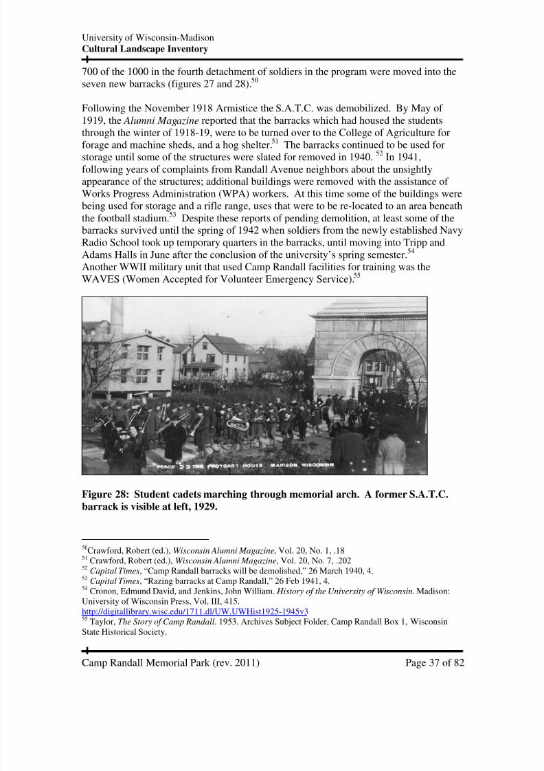
700 of the 1000 in the fourth detachment of soldiers in the program were moved into theseven new barracks (figures 27 and 28).50
Following the November 1918 Armistice the S.A.T.C. was demobilized. By May of 1919, the Alumni Magazine reported that the barracks which had housed the students
through the winter of 1918-19, were to be turned over to the College of Agriculture forforage and machine sheds, and a hog shelter.51 The barracks continued to be used forstorage until some of the structures were slated for removed in 1940. 52 In 1941,following years of complaints from Randall Avenue neighbors about the unsightlyappearance of the structures; additional buildings were removed with the assistance of Works Progress Administration (WPA) workers. At this time some of the buildings werebeing used for storage and a rifle range, uses that were to be re-located to an area beneaththe football stadium.53 Despite these reports of pending demolition, at least some of thebarracks survived until the spring of 1942 when soldiers from the newly established NavyRadio School took up temporary quarters in the barracks, until moving into Tripp andAdams Halls in June after the conclusion of the university’s spring semester.54
Another WWII military unit that used Camp Randall facilities for training was theWAVES (Women Accepted for Volunteer Emergency Service).55
Figure 28: Student cadets marching through memorial arch. A former S.A.T.C.
barrack is visible at left, 1929.
50Crawford, Robert (ed.), Wisconsin Alumni Magazine, Vol. 20, No. 1, .1851 Crawford, Robert (ed.), Wisconsin Alumni Magazine, Vol. 20, No. 7, .20252 Capital Times, “Camp Randall barracks will be demolished,” 26 March 1940, 4.53 Capital Times, “Razing barracks at Camp Randall,” 26 Feb 1941, 4.54 Cronon, Edmund David, and Jenkins, John William. History of the University of Wisconsin. Madison:University of Wisconsin Press, Vol. III, 415.http://digitallibrary.wisc.edu/1711.dl/UW.UWHist1925-1945v3 55 Taylor, The Story of Camp Randall. 1953. Archives Subject Folder, Camp Randall Box 1, WisconsinState Historical Society.

7/30/2019 Camp Randall Memorial Park _rev 2011
http://slidepdf.com/reader/full/camp-randall-memorial-park-rev-2011 38/82
University of Wisconsin-MadisonCultural Landscape Inventory
Camp Randall Memorial Park (rev. 2011) Page 38 of 82
Post-WWII, student veterans trailer housing
With demobilization following V-E Day (Victory in Europe) university planners rushedto find housing accommodations for veterans who were arriving in Madison to continue(or begin) their studies. Available housing stock could not accommodate the flood of
students. In particular older and married veterans with families could not find affordablehousing. On August 11, 1945 (just days before V-J Day--Victory over Japan Day, theofficial end of WWII) the university board of regents passed a resolution to accept theoffer of the National Housing Authority for 100 trailers (and auxiliary equipment), at acost of $40,000. The trailers would be set up in the area north of the arch, in the vicinityof the former S.A.T.C. barracks. 56 This first grouping of trailers would later be namedRandall Park.
Sometimes referred to as "GI-ville" or “Fred’s Fertile Fields,” (in honor of universitypresident E.B. Fred), the first 100 or so trailers were brought from Badger OrdinanceWorks near Baraboo.57 One account describes the housing in 1945:
“Trailers are of two types, the single units which rent for $25 and the expandable or“wing-type” units which rent for $32.50. Each provides sleeping for four, two burnerelectric plates and ovens, ice boxes, folding chairs, and fuel oil heaters…Running in asemi-circle through the archway entrance to Camp Randall from Randall avenue andback to that avenue at the north end of the camp is the village’s main street, a newlycompleted gravel road. Connecting each of the trailers and the central buildings arewooden walkways.”58
A second trailer area, Monroe Park, would soon be established in the area south of thearch. When at peak capacity, the two camps included just over two hundred trailers. Thetrailers in the western half of Randall Park were the first to be removed, around
December of 1949 in order to accommodate the construction of the west wing of Engineering building (figure 29). The remainder of Randall Park was closed withconstruction of the east wing of the Engineering building, around April of 1951. 59 ByJanuary 1953, the Daily Cardinal reported that many of the trailers that remained inMonroe Park were in poor shape, having provided housing for nearly twice their normallife expectancy.60 The Monroe Park closed by June 1954, with the adjacent CampRandall Memorial Practice Building construction project already underway.61
56 Board of Regents minutes, 11 Aug 1945.57 Milwaukee Journal, “Life in U.W.'s GIville," 21 Oct 1945.58 Haight, Polly Coles (ed.). “The Campus,” The Wisconsin Alumnus. Vol. 47, No. 1, 9.59 Feldman, 262.60 The Daily Cardinal. “Trailers To Disappear From Temporary Housing Project," 13 Jan 1953, 2.61 Wire News: From the University of Wisconsin News Service, Madison, WI, 7 Oct 1953.

7/30/2019 Camp Randall Memorial Park _rev 2011
http://slidepdf.com/reader/full/camp-randall-memorial-park-rev-2011 39/82
University of Wisconsin-MadisonCultural Landscape Inventory
Camp Randall Memorial Park (rev. 2011) Page 39 of 82
Figure 29: Aerial view Randall and Monroe Park trailer camps circa 1950. Half of the
trailers from Randall Park (upper left) have been removed to accommodate the
construction of the west wing of the new Engineering building. Monroe Park trailers (center
to lower left) would remain until 1954.
Development of the Engineering campus
The north end of Camp Randall was the first area to witness concentrated buildingdevelopment. In 1909, the university successfully lured the U.S Department of Agriculture’s Forest Products Laboratory to campus with the promise of a new building.This structure housed the lab until 1931 when a newer facility was constructed on thewest end of campus. The building currently houses the College of Engineering’sDepartment of Materials Science and Engineering.
The next academic building to be built in this area was the so-called Randall Shops(informally referred to as the “sawtooth building” due to the shape of its roof profile). Inan effort to alleviate a rapidly expanding engineering student population, campus
architect Peabody convinced the board of regents to relocate engineering shops to theCamp Randall site in 1920.
It was not until 1931 with the completion of the Mechanical Engineering building that theengineering department was able to vacate their former facility on Bascom Hill (currentlythe Education Building.) In 1937, the regents granted the State Highway Commission a40-year lease for the use of the triangular piece of land at the corner of North RandallAve. and Engineering Drive. The commission built and operated the State Highway
7/30/2019 Camp Randall Memorial Park _rev 2011
http://slidepdf.com/reader/full/camp-randall-memorial-park-rev-2011 40/82
University of Wisconsin-MadisonCultural Landscape Inventory
Camp Randall Memorial Park (rev. 2011) Page 40 of 82
Laboratory here for testing materials and fabricating posts for highway signs. In 1977,when the lease expired, the State Highway Lab moved to Truax Field and the land andoffices reverted back to the university. Computer Aided Engineering Center is the currentoccupant of the former highway lab.
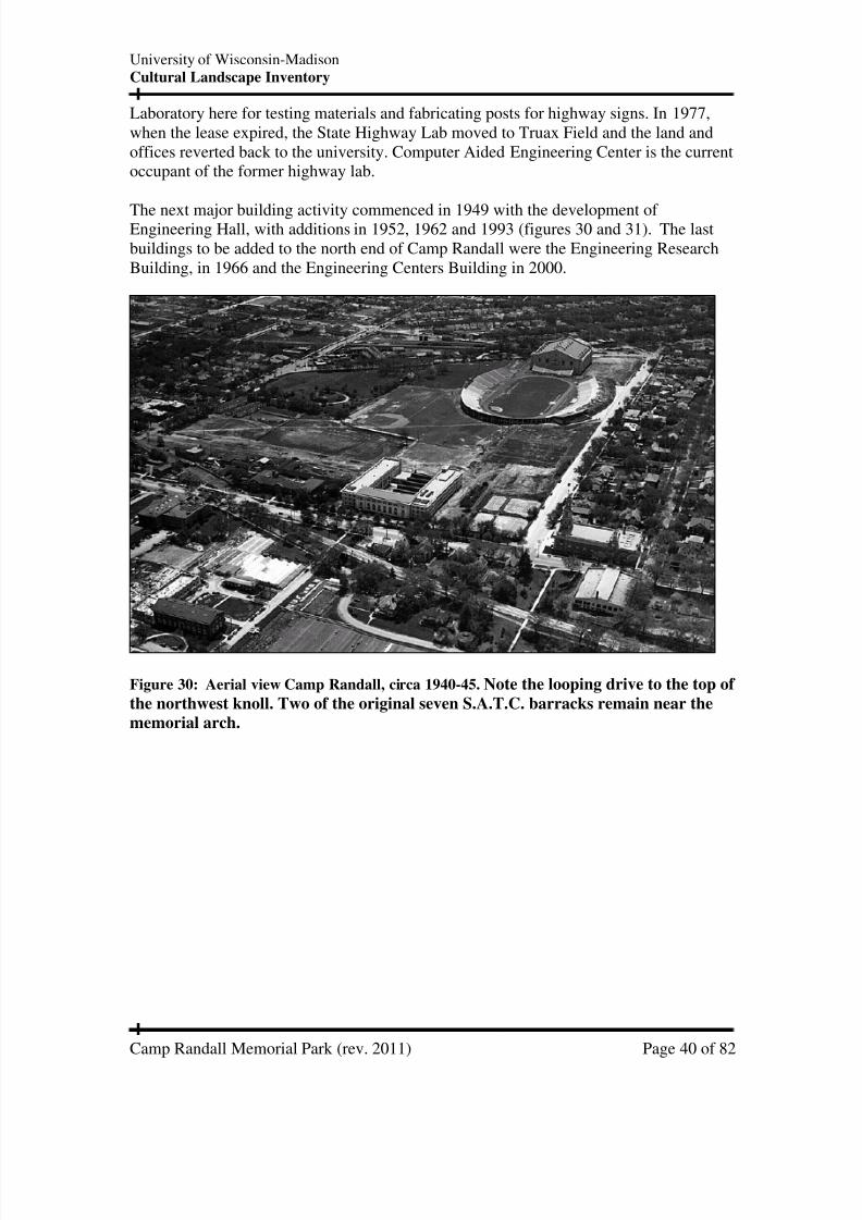
The next major building activity commenced in 1949 with the development of Engineering Hall, with additions in 1952, 1962 and 1993 (figures 30 and 31). The lastbuildings to be added to the north end of Camp Randall were the Engineering ResearchBuilding, in 1966 and the Engineering Centers Building in 2000.
Figure 30: Aerial view Camp Randall, circa 1940-45.Note the looping drive to the top of
the northwest knoll. Two of the original seven S.A.T.C. barracks remain near the
memorial arch.

7/30/2019 Camp Randall Memorial Park _rev 2011
http://slidepdf.com/reader/full/camp-randall-memorial-park-rev-2011 41/82
University of Wisconsin-MadisonCultural Landscape Inventory
Camp Randall Memorial Park (rev. 2011) Page 41 of 82
Figure 31: Aerial view Camp Randall, circa 1938-45. The memorial park includes dense
vegetation along the northern, southern, and portions of the western boundary. There is no
sidewalk cutting through the middle of the property.
Adjacent land use encroaches on the Memorial Park
In the fall of 1953, the regents decided to locate a new athletic practice building adjacentto the Camp Randall Stadium, replacing the Athletic Annex on Langdon Street. The
planned siting of this new facility would diminish the size of the memorial park, resultingin citizen and veterans group objections. To address some of the protestor’s concerns, theuniversity passed a resolution designating the new building as a memorial to Unionveterans of the Civil War and requested that the legislature make the rest of the park aperpetual memorial.62 The official building name was “Camp Randall Memorial PracticeBuilding,” later renamed “Camp Randall Sports Center.” The building was designed byarchitect Fitzhugh Scott of Ammons and Whitney, NY, with groundbreaking on February5, 1954 and formal dedication on May 18, 1956.63
In the 1980s, the university proposed a second athletic training center that would againencroach on the park, the McClain Athletic Facility. Designed by Bowen Williamson and
Zimmerman of Madison, the new indoor practice field was constructed in 1989 on landpartially located within the park boundary. To account for this encroachment, a landexchange was made between the park and the university. A triangular area of land southof the Camp Randall Sports Center (referred to as “A” in figure 3) was added to the park
62 Wisconsin Alumni Magazine. "Largest Campus Classroom." March 1957, Volume 58, No. 11. 63 Feldman, 286.

7/30/2019 Camp Randall Memorial Park _rev 2011
http://slidepdf.com/reader/full/camp-randall-memorial-park-rev-2011 42/82
University of Wisconsin-MadisonCultural Landscape Inventory
Camp Randall Memorial Park (rev. 2011) Page 42 of 82
in exchange for land that was needed for the construction of the McClain Athletic Facility(marked “B” in figure 3).64
In 1986, in conjunction with planning for the new McClain Athletic Facility, theWisconsin legislature amended the 1911 law that created the Memorial Park to read:
No structures other than memorials approved by the board and walks, roads, andsubterranean footings may be placed or erected upon Camp Randall memorial park unlessauthorized by the legislature; nor shall the park be used for any purpose other than amemorial park.65
The amendment also redefined the park to its current boundary (figure 3).
64 FPM Planning and Landscape Architecture, G.A.R. Park project files, April 1986. 65 1985 Wisconsin Act 339, amendment to laws of 1911, Chapter 567, Date of enactment 12 June 1986,Date of Publication 25 June 1986.

7/30/2019 Camp Randall Memorial Park _rev 2011
http://slidepdf.com/reader/full/camp-randall-memorial-park-rev-2011 43/82
University of Wisconsin-MadisonCultural Landscape Inventory
Camp Randall Memorial Park (rev. 2011) Page 43 of 82
EXISTING CONDITIONS
Existing conditions for Camp Randall Memorial Park were initially recorded in 2004,
with revisions through July 2011. For current conditions, field verification is advised.
Landscape zones:
Camp Randall Memorial Park can be characterized by five discrete landscape zones,defined by topographic features, vegetation types and cultural resources (figure 32).
Zone A: Vegetative buffer
The park edges to the east, west and north contain buffer vegetation that helps todefine the park space and limit impacts from adjoining use.
Zone B: Memorial arch
This narrow corridor at the north end of the park is dominated by the granite arch
which serves as a portal to the park. A well-used service drive passes through thearch and extends to the northeast corner of the McClain Athletic Facility. Thetopography, vegetation, and structures create an enclosed feeling in this zone.The corridor is used today by bikes, pedestrians, mopeds, and service vehicleswhich in general, use this route to access to the athletic facilities and BreeseTerrace, to the west of the park.
Zone C: Northwest and northeast knolls
The two knolls at the north end of the open lawn area create a feeling of enclosureand removal from the activity that surrounds the park. Many of the plants in thisportion of the park are mature, including deciduous shade trees and shrubs. The
plants are clustered in massed groups that surround turf covered slopes. Aflagpole, cannon, and commemorative plaque are located on the northwesternknoll. A cannon is located on the northeast knoll. The west slope of the northwestknoll has been truncated, probably as a result of the construction of the McClainAthletic Facility
Zone D: Open lawn
This portion of the park is characterized by open turf grass and widely spacedtrees. Park visitors use this area for activities such as sunbathing, as well as,Frisbee and baseball “catch” activities. A concrete sidewalk which extends fromthe arch area to the southeast corner of Camp Randall Sports Center divides this
zone (figure 33).
Zone E: South entry and lawn.
This sector of the park includes two distinct areas. South of the Athletic Hall of Fame plaza is a triangular open lawn with young trees and a cannon. Theremaining area to the northeast is characterized by a stone retaining wall(necessitated by the installation of a utility vault) and a concrete plaza with thereconstructed guardhouse and historical marker.

7/30/2019 Camp Randall Memorial Park _rev 2011
http://slidepdf.com/reader/full/camp-randall-memorial-park-rev-2011 44/82
University of Wisconsin-MadisonCultural Landscape Inventory
Camp Randall Memorial Park (rev. 2011) Page 44 of 82
Figure 32: Landscape zones, 2011

7/30/2019 Camp Randall Memorial Park _rev 2011
http://slidepdf.com/reader/full/camp-randall-memorial-park-rev-2011 45/82
University of Wisconsin-MadisonCultural Landscape Inventory
Camp Randall Memorial Park (rev. 2011) Page 45 of 82
Figure 33: View of open lawn and vegetative buffer, looking north, 2004.
Land Use
South of University Avenue, the UW-Madison campus has only a few publicly accessibleopen spaces. Engineering Mall, the lawn to north of the Kohl Center and the recreationfield southeast of Witte Hall are popular areas where the campus community can recreateand relax outdoors. Camp Randall Memorial Park, tucked away adjacent to athletic andengineering campus buildings, offers a quieter and more pastoral feeling compared tothese other open spaces. The park is used for informal small-group recreational activitiessuch as playing Frisbee, tossing a football or baseball, and sunbathing. However, thegreatest number of visitors to the park are primarily using it as a pedestrian transit routebetween engineering and athletic facilities, and as a gateway to the adjoining cityneighborhoods.
The park receives intensive use prior to UW football home games when Badger SportsProperties, the fundraising branch of the athletics department, erects large picnic tents forthe exclusive use of their corporate sponsors. The tents and adjacent “beer gardens” areused by the sponsors to host clients and employees to a pre-game party. Corporatebanners and products (such as new model cars) are sometimes on display in the park aspart of the sponsorship package. The UW marching band has established a tradition of parading through the arch prior to each home football game. The National W Club, an
7/30/2019 Camp Randall Memorial Park _rev 2011
http://slidepdf.com/reader/full/camp-randall-memorial-park-rev-2011 46/82
University of Wisconsin-MadisonCultural Landscape Inventory
Camp Randall Memorial Park (rev. 2011) Page 46 of 82
affiliate of the athletics division, also uses the park for its annual Athletic Hall of Fameceremony in late summer.
In the spring of 1998 and 1999, the Wisconsin Veterans Museum hosted Civil War re-enactments on the site in conjunction with the state sesquicentennial. In the summer of
2010, as part of Abraham Lincoln’s birthday bicentennial, the 1st
Brigade Brass Band, aCivil War era musical re-enactor group, provided a free concert in the park, including anappearance by a Lincoln impersonator. Students from the nearby Engineering campusalso use the park to conduct land surveying exercises.
The maintenance of the park and the adjacent Camp Randall Sports Center results inservice vehicle traffic throughout the park. These vehicles use the arch service road,paths, and lawn as access and parking areas. Boulders, post and chain fencing, and signshave been installed by the Physical Plant grounds department to control this use, withmoderate compliance. One of the most visible impacts of service use is the ruttingfrequently located on either side of the central walkway. At six-feet wide, the walkway is
too narrow to accommodate many, but not all, of the maintenance, delivery and snowremoval vehicles that traverse the park.
Spatial Organization
The park edges are defined by buildings to the north and west and roads to the east andsouth. The northern boundary is the service drive/sidewalk on the south side of Engineering Hall; the western boundary is the service drive/sidewalk on the east side of the Camp Randal Sports Center and McClain Athletic Facility; the southern boundary isthe public sidewalk on Monroe Street; and the eastern boundary is the public sidewalk onRandall Avenue.
The park is visually enclosed by the buildings and vegetation that surround it (LandscapeZone A, figure 32), including Engineering Hall, the Camp Randall Sports Center,McClain Athletic Facility, Memorial Arch, and the vegetation screening around theperimeter. In 2009, the mature vegetative screen created by shrubs along the RandallAvenue park edge was altered by the utility project in this area. The mature shrubs wereremoved prior to excavation activities. New shrubbery, smaller in stature, was planted atthe conclusion of the project. A single main walkway slices diagonally through thecentral portion of the park, bisecting the park into eastern and western sections. Thewalkway is flanked with light posts.
Topography
The two knolls on the north end of the park (Landscape Zone C, figure 32) partiallybuffer noise and the visual intrusion of the traffic on Randall Avenue. The northwestknoll partially screens views of Engineering Hall as well as the service drive and firelanes to the north. The change in grade also offers a prominent setting for the flagpole,cannon, and large shade trees.

7/30/2019 Camp Randall Memorial Park _rev 2011
http://slidepdf.com/reader/full/camp-randall-memorial-park-rev-2011 47/82
University of Wisconsin-MadisonCultural Landscape Inventory
Camp Randall Memorial Park (rev. 2011) Page 47 of 82
Circulation
At the north end of the park (Landscape Zone B, figure 32), a service drive passes underthe arch and continues west to the Engineering Hall dock areas and the McClain AthleticFacility. The drive is used by bicyclists, pedestrians, mopeds and service vehicles.Peabody’s 1914 “Diagram of New Athletic Field at Camp Randall (figure 17), proposed
that this drive would continue all the way to Breese Terrace. No evidence has beenlocated that this extension was ever built.
Approximately 50 feet west of the arch the drive splits, with one branch arcing to thenorth. This broad intersection appears to be a vestige of the former road that ran throughthe center of the former Randall Park trailer camp (figure 29). There are additionalservice drives/fire lanes south of Engineering Hall, and along the east side of the CampRandall Sports Center/McClain Athletic Facility.
The “1907 University of Wisconsin Atlas” includes a plan of the sidewalks and loopingdrive associated with memorial arch (figure 34). 66 A close examination of figure 21
clearly shows the sidewalk segment on the front side of the arch and a portion of the trailthat led to the crest of the knoll. The driveway that passed through the arch hooks to thesouth to form a ring around the northwest knoll. It would appear that the width of thisknoll drive would have accommodated a carriage although no known photographs havebeen found to confirm this use. A slight depression is visible today on top of the knoll,marking the location of the upper loop. The western most portion of the drive was lost,likely at the time that the site was graded to construct the nearby Camp Randall SportsCenter in 1953. The McClain Athletic Facility currently occupies the site of the westernportion of the drive (figure 35).
66 Arthur Peabody, et al. 1907 University of Wisconsin Atlas, Sheet 14. This site plan is included in a
bound large-format volume that was likely prepared in conjunction with master planning efforts associatedwith Laird and Cret. It is apparent that some of the drawings in this volume, including this one, were addedor modified subsequent to the 1907 production date. Only one copy of this atlas is presently known toexist. It is currently located at the Campus Planning and Landscape Architecture department in the WARFbuilding.
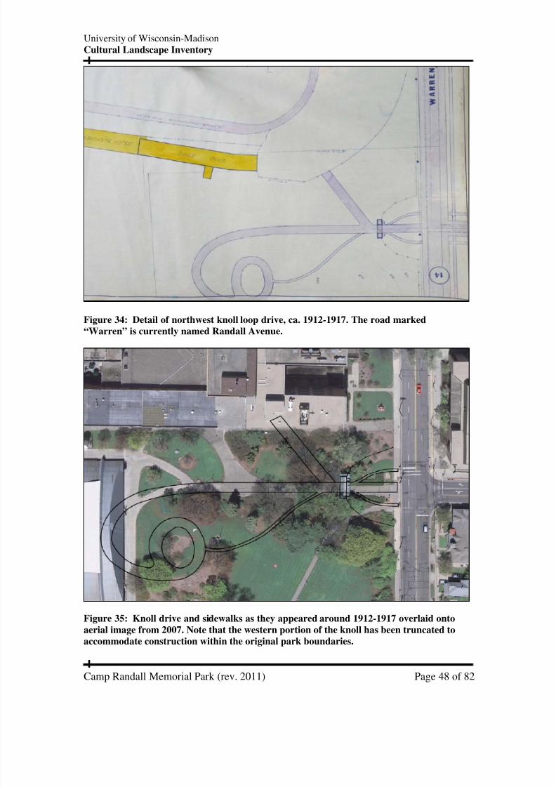
7/30/2019 Camp Randall Memorial Park _rev 2011
http://slidepdf.com/reader/full/camp-randall-memorial-park-rev-2011 48/82
University of Wisconsin-MadisonCultural Landscape Inventory
Camp Randall Memorial Park (rev. 2011) Page 48 of 82
Figure 34: Detail of northwest knoll loop drive, ca. 1912-1917. The road marked
“Warren” is currently named Randall Avenue.
Figure 35: Knoll drive and sidewalks as they appeared around 1912-1917 overlaid onto
aerial image from 2007. Note that the western portion of the knoll has been truncated to
accommodate construction within the original park boundaries.
7/30/2019 Camp Randall Memorial Park _rev 2011
http://slidepdf.com/reader/full/camp-randall-memorial-park-rev-2011 49/82
University of Wisconsin-MadisonCultural Landscape Inventory
Camp Randall Memorial Park (rev. 2011) Page 49 of 82
Currently the main pedestrian sidewalk through the park begins at Randall Avenue, justsouth of the arch, and cuts through the park at a diagonal to the southwest to meet thesidewalk at Monroe Street. This central walk provides a well-used transit route forpedestrians. Although a sign indicates that mopeds are not allowed to use the walkway,
no such sign exists for service vehicles, which routinely use the six-foot wide concretewalkway. Constructed around 1965, the walkway is showing signs of wear, which maybe partially due to the weight of the vehicles as well as old age.
Vegetation
Park trees and shrubs are diverse and generally healthy. Many unique specimens havebeen planted over the past 50 years. The Longenecker landscape plans from 1957 (figure36 and 37) show designs that are symmetrical and relatively formal. The plans includetrees in front of the arch, and shrubs planted quite close together. Since 1957,management practices at the site have included strengthening species diversity, possibly
as an educational opportunity or to encourage disease resistance.
In the fall of 2009 much of the vegetation east of the arch was removed and replanted inconjunction with nearby utility work. Much of the shrub buffer along Randall Avenuesouth of the arch was similarly removed in conjunction with utility excavations and vaultconstruction. This edge is currently more open than in the recent past, however, newshrub plantings will provide a visual screen in time.
Three large pin oaks (Quercus palustris) in the park have been designated as Wisconsinchampion trees, (the largest specimens of a given species known in the state). Thesetrees may have been planted around the time of the arch dedication to commemorate
Civil War era veterans. In 2005, a broad protective mulch ring was added around thebases of the largest park trees, including the pin oaks. This action was taken in responseto concerns about soil compaction as a result of the practice of erecting party tentsbeneath the trees during pre-game football events. The mulch rings were installed uponthe recommendation of a consulting arborist.67
Other large park trees include elm, oak, basswood, walnut, and Norway maples. At thesouthwest corner of the park, near the Athletic Hall of Fame Terrace, a flowering rosebed contrasts with other areas of the park, where trees and shrubs dominate the landscape.
67 Alison, R. Bruce, arborist treatment report, June 17, 2005

7/30/2019 Camp Randall Memorial Park _rev 2011
http://slidepdf.com/reader/full/camp-randall-memorial-park-rev-2011 50/82
University of Wisconsin-MadisonCultural Landscape Inventory
Camp Randall Memorial Park (rev. 2011) Page 50 of 82
Figure 36: Planting plan, Camp Randall Memorial, Longenecker, 1957.

7/30/2019 Camp Randall Memorial Park _rev 2011
http://slidepdf.com/reader/full/camp-randall-memorial-park-rev-2011 51/82
University of Wisconsin-MadisonCultural Landscape Inventory
Camp Randall Memorial Park (rev. 2011) Page 51 of 82
Figure 37: Planting plan, Camp Randal Memorial Arch, Longenecker, 1957.

7/30/2019 Camp Randall Memorial Park _rev 2011
http://slidepdf.com/reader/full/camp-randall-memorial-park-rev-2011 52/82
University of Wisconsin-MadisonCultural Landscape Inventory
Camp Randall Memorial Park (rev. 2011) Page 52 of 82
Structures and Small Scale Features
The park is home to the greatest concentration of commemorative objects on the UW-Madison campus, befitting its function as a memorial to the veterans of the Civil War(figure 38).
Figure 38: Existing conditions plan, 2010.

7/30/2019 Camp Randall Memorial Park _rev 2011
http://slidepdf.com/reader/full/camp-randall-memorial-park-rev-2011 53/82
University of Wisconsin-MadisonCultural Landscape Inventory
Camp Randall Memorial Park (rev. 2011) Page 53 of 82
Memorial Arch
In the fall of 2009, in conjunction with underground utility work along Randall Avenue,new landscaping and lighting amenities were installed on the east facing side of the arch.
Overhead utility wires that once impeded views of the arch (as viewed from DaytonStreet) were routed underground. Two light standards, with pole mounted spot lights nowilluminate the ground plane. This new lighting replaced damaged ground mounted lights.New plantings replaced the former yew hedges (figure 39).
In late 2009, in conjunction with utility trench work on the west side of Randall Avenue,new landscaping and lighting fixtures were installed on the east side of the arch. Newfloodlights were mounted to the light poles to highlight the arch and statuary.
Figure 39: Camp Randall Memorial Arch (with 2009 landscaping), 2010.
During November 2010 the arch received the following maintenance treatments: power-washing of all stone and statuary surfaces, tuck-pointing masonry joints, and replacementof the copper roof flashing. The plaques on the interior of the arch were refinished inAugust 2011.

7/30/2019 Camp Randall Memorial Park _rev 2011
http://slidepdf.com/reader/full/camp-randall-memorial-park-rev-2011 54/82
University of Wisconsin-MadisonCultural Landscape Inventory
Camp Randall Memorial Park (rev. 2011) Page 54 of 82
Lincoln Bicentennial sign
An interpretive sign was installed by the Wisconsin Lincoln Bicentennial Commission inDecember 2009 southwest of the memorial arch (figure 40). The sign is part of a series
of markers identifying Wisconsin places where Lincoln either visited or his policiessignificantly influenced history. While Lincoln never visited Camp Randall, the signrecognizes his war-time presidency and his enactment of the Morrill Land-Grant CollegeAct of 1862. The Wisconsin legislature subsequently designated the University of Wisconsin as the state’s land grant university.
Figure 40: Lincoln Bicentennial sign, 2010.
G.A.R. stone bench
Located just to the south of the northwest knoll, is a stone bench (figure 41) with thefollowing inscription:
"They kept the stars in the field of Blue, they held the states to allegiance true. Tothem the Nation's debt is due, and the Nation must never forget. Erected to honorour fathers the Grand Army of the Republic by the Daughters of Union Veteransof the Civil War 1861-1865. Dedicated September 5, 1937.”
The bench was dedicated by the national commander-in-chief of the G.A.R. and thenational president of the Daughters of Union Veterans of the Civil War during theirnational convention held in Madison.68
68 Wisconsin State Journal, “Stone bench dedicated at Camp Randall,” 7 Sep 1937, 5.

7/30/2019 Camp Randall Memorial Park _rev 2011
http://slidepdf.com/reader/full/camp-randall-memorial-park-rev-2011 55/82
University of Wisconsin-MadisonCultural Landscape Inventory
Camp Randall Memorial Park (rev. 2011) Page 55 of 82
Figure 41: Grand Army of the Republic stone bench, 2004.
Cannon
At least three cannon arrived from the capitol park soon after the dedication of thememorial arch in 1912. By 2005 there were five cannon on display in the park. Severalchanges to the collection occurred between 2005 and 2010 to address safety concernsassociated with wooden cannon carriages with rotted components. As of November 2010
three cannon are located in the park (see figure 38 for locations).69 Currently all cannontubes are mounted on metal replica carriages, which should ensure their continued publicdisplay.
69 Einstein, Daniel, report, Camp Randall Memorial Park Cannon Inventory, revision Nov 18, 2010,Facility Planning and Management files.

7/30/2019 Camp Randall Memorial Park _rev 2011
http://slidepdf.com/reader/full/camp-randall-memorial-park-rev-2011 56/82
University of Wisconsin-MadisonCultural Landscape Inventory
Camp Randall Memorial Park (rev. 2011) Page 56 of 82
MG &Co Cannon: South side of Camp Randall Sports Center (figure 42)This Civil War era “6-pounder” cannon is mounted on a new all-metal replica carriage.70 The cannon barrel (also refereed to as the “tube”) was provided on long-term loan fromthe Wisconsin Veterans Museum in 2008. It had formerly been on display at the museum
and was provided in exchange for the Leeds and Co.-Shiloh cannon (figure 45).Thefoundry marking “MG&Co CINC OH” is stamped on the right trunion. Its war-timeprovenance is not known.
Figure 42: MG & Co. cannon at re-dedication ceremony with members of the Sons of Union
Veterans of the Civil War, 2008.
70 The carriage was built by the Paulson Brothers Ordinance Corporation of Clear Lake, WI. The carriage
was funded in part by donations from the Sons of Union Veterans of the Civil War, (Henry Harnden CampNo. 2). A re-dedication ceremony was held October 4, 2008.

7/30/2019 Camp Randall Memorial Park _rev 2011
http://slidepdf.com/reader/full/camp-randall-memorial-park-rev-2011 57/82
University of Wisconsin-MadisonCultural Landscape Inventory
Camp Randall Memorial Park (rev. 2011) Page 57 of 82
MG Greenwood Cannon: Northeast knoll (figure 43)This Civil War era “6-pounder” is mounted on an all-metal replica carriage, likely builtcirca 1920-1940.71 The trunion is stamped “MG Greenwood Cincy OH 1861.” This tubeprobably came to the Camp Randall park in the early 1910s, transferred from display at
the capitol park. Its war-time provenance is not known.
Figure 43: MG Greenwood cannon, 2010.
71 Bill Brewster, former Wisconsin Veteran’s Museum curator, personal communication, 2000.

7/30/2019 Camp Randall Memorial Park _rev 2011
http://slidepdf.com/reader/full/camp-randall-memorial-park-rev-2011 58/82
University of Wisconsin-MadisonCultural Landscape Inventory
Camp Randall Memorial Park (rev. 2011) Page 58 of 82
U.S. No. 332 Cannon: Northwest knoll (figure 44)This Civil War era, Napoleon “12-pounder” is mounted on a new all-metal replicacarriage.72 The gun was produced in a federal arsenal as indicated by the letters “U.S”stamped on the top of the tube. The muzzle face has the following marks: “No. 332,”
“1863” and “1228.” This tube probably came to the park in the early 1910s, transferredfrom display at the capitol park. Its war-time provenance is not known.
Figure 44: U.S. No. 332 cannon, 2010.
Leeds & Co – Shiloh: Formerly northwest knoll (figure 45)The Camp Randall cannon with the most historically direct and verifiable significance toWisconsin’s role in the Civil War is the so-called “Shiloh” tube. The gun was capturedby the 14th Regiment of the Wisconsin Volunteers on April 7, 1862 at the Battle of Pittsburg Landing, Tennessee (commonly referred to today as the Battle of Shiloh).
1st Lieutenant George Stanley of Company D “spiked” (disabled) the Confederate cannonon the field of battle. On the top of the tube the details of the battlefield exploit havebeen engraved. The foundry marking of “LEEDS & Co. New Orleans” is stamped onright trunion.
72 The carriage was built by the Paulson Brothers Ordinance Corporation of Clear Lake WI. The carriagewas funded in part by donations from the Sons of Union Veterans of the Civil War, (Henry Harnden CampNo. 2 and National Headquarters) and the Milwaukee Civil War Roundtable. The carriage was installedSeptember 23, 2009. A re-dedication ceremony was held May 31, 2010.

7/30/2019 Camp Randall Memorial Park _rev 2011
http://slidepdf.com/reader/full/camp-randall-memorial-park-rev-2011 59/82
University of Wisconsin-MadisonCultural Landscape Inventory
Camp Randall Memorial Park (rev. 2011) Page 59 of 82
Given its known battlefield provenance, Bill Brewster, former curator of the WisconsinVeterans Museum, accepted the tube for inclusion in the museum collection in October of 2007. It is currently on display in the entrance lobby of the museum on the CapitolSquare.
Interestingly, prior to being transferred to the museum, this cannon was positioned on thenortheast knoll, however a commemorative plaque honoring the soldiers who died at thisbattle is located on the northwest flagpole knoll. It is not known if the cannon had onceheld a position on the more prominent northwest knoll.
Figure 45: Leeds and Co.-Shiloh cannon, moved to Veterans Museum, 2007.
Spanish-American War Cannon: Formerly southeast corner of Camp Randal SportsCenter (figure 46)This fortress-based cannon tube was captured in Cuba from the Spanish in 1898 andtransferred by the War Department to the City of Madison in April 1900. A wood andmetal carriage, which may have been assembled from a railroad handcar axle and oldwagon wheels, was built to accommodate the massive gun. This type of cannon wasdesigned for deployment in a fort and therefore, would not have been mounted to acarriage with such large wagon wheels.
The Spanish colonial era provenance of this cannon was not appropriate for a Civil Warmemorial park (and its historically inaccurate carriage was unsafe due to decay). TheVeteran Affairs Board concurred with a recommendation to remove the tube from displayat Camp Randall Memorial Park. On November 18, 2010, the tube was transferred to theWisconsin Veterans Museum. It is currently in storage until an appropriate museumdisplay can be arranged.

7/30/2019 Camp Randall Memorial Park _rev 2011
http://slidepdf.com/reader/full/camp-randall-memorial-park-rev-2011 60/82
University of Wisconsin-MadisonCultural Landscape Inventory
Camp Randall Memorial Park (rev. 2011) Page 60 of 82
Figure 46: Spanish-American War cannon, 2010.
14th
Wisconsin Volunteer Infantry plaque
Adjacent to the cannon on the northwest knoll is a plaque honoring the soldiers of the14th Wisconsin Volunteer Infantry who were killed on April 7, 1862 at the Battle of Shiloh (figure 47). The plaque was dedicated by Captain F.H. Magdeburg to hiscomrades. In 2007 the cast-iron plaque broke into two parts. The vertical crack wasrepaired by the campus machine shop using epoxy and a steel backer plate. It was painted
a drab olive color at this time.
Figure 47: 14th Wisconsin Volunteer Infantry plaque, 2010.

7/30/2019 Camp Randall Memorial Park _rev 2011
http://slidepdf.com/reader/full/camp-randall-memorial-park-rev-2011 61/82
University of Wisconsin-MadisonCultural Landscape Inventory
Camp Randall Memorial Park (rev. 2011) Page 61 of 82
Flagpole
At the crest of the northwest knoll, is a single steel flagpole (figure 48). It is not knownwhen the flagpole was erected. A ground-mounted spotlight was installed duringNovember 2010 to illuminate the flag, so as to permit 24-hour display. Prior to this time
the US flag had been flown at night without illumination, contrary to flag displayprotocol. This issue was rectified when a student veteran brought the situation to theattention of the chancellor.
Figure 48: Flagpole at northwest knoll, 2011. Figure 49: 23 Wis. Inf. stone marker,
2011.
23 Wisconsin Infantry granite marker
A small commemorative marker is located just south of the flagpole on the northwestknoll (figure 49). The marker is engraved: “23 Wis. Inf. 1861-1865.” It is not knownwhen this marker was placed in the park. It is the only commemorative object within theoval landscape space created by the northwest knoll loop drive.

7/30/2019 Camp Randall Memorial Park _rev 2011
http://slidepdf.com/reader/full/camp-randall-memorial-park-rev-2011 62/82
University of Wisconsin-MadisonCultural Landscape Inventory
Camp Randall Memorial Park (rev. 2011) Page 62 of 82
Guard HouseAt the southeast corner of the park sits a structure referred to as the “Guard House”(figures 50 and 51). This structure, though somewhat altered from its originalconfiguration, is the only artifact at the memorial park with a known Camp Randall Civil
War era provenance.
The original building would likely have served to shelter a military guard and provide asecure place to detain soldiers, before or after trial for minor offenses. It is not knownexactly when the current Guard House was placed on display in the memorial park,however, it likely happened between 1914 and 1936 based on newspaper accounts..
At the conclusion of the war in 1865, Camp Randall structures, including barracks andother wooden buildings, were sold to the public at auction. Henry C. Lamp, (who hadassisted with the horses at Camp Randall during the war and who also delivered bread tothe soldiers), was able to purchase a former camp guard house at this time. He moved the
18 feet wide and 40 feet long structure to his homestead at 719 Johnson Street inMadison, where he converted it for use as a granary.
The structure that Lamp purchased was described in a 1914 account in the Madison
Democrat newspaper:
“The walls were constructed of a double layer of roughly finished two-inch oak planks. The first layer of planks are laid parallel to the ground while the others runin the opposite direction, making it absolutely secure for the purpose for which itwas used. These planks are fastened together at intervals of about six inches withhome made spikes which have been riveted on both sides…All along the sides of
the house, about four and half feet from the ground, are openings which resemble‘port holes’ about two feet apart which served as windows. These openings arenot more than four inches wide and eight inches high, making it impossible for adisorderly to make his escape through them.”73
The Madison Democrat reporter suggested that it had always been Lamp’s intention topreserve the building.
“Since the recent death of Mr. Lamp, the guard house has attracted the attentionof several civil war veterans who favor the purchase of the little building and itsremoval to some place where it can be remodeled as a relic of the civil war. Some
have suggested that it be taken back to Camp Randall.
74
An inspection of the current structure on display at Camp Randall Memorial Park confirms that many of the building components described in the 1914 article are extant.However, it is also clear that the current structure has been “remodeled.” There is no
73The Madison Democrat . “Old Guard House Remains Intact.” Oct. 3, 1914.74 Ibid.

7/30/2019 Camp Randall Memorial Park _rev 2011
http://slidepdf.com/reader/full/camp-randall-memorial-park-rev-2011 63/82
University of Wisconsin-MadisonCultural Landscape Inventory
Camp Randall Memorial Park (rev. 2011) Page 63 of 82
operable door to the structure and its overall dimensions are much smaller than theoriginal building. The roof is now clad with thin wooden boards which would not havebeen adequate for a secure jail cell. Heavy wire mesh has been placed over the smallwindow openings.
No additional records have been located as to how or when the current guard house cameback to Camp Randall. The next known dated reference to the guard house is a photoaccompanying an article written in conjunction with the City of Madison’s centennial in1936. The photo is captioned “The Old Guard House” and “A Terror to Evil Doers.”The article does not specifically mention the guard house:
“Directly across the parade grounds stood the bull pen, a ‘terror to evil doers.’Securely inclosed (sic) by a twelve-foot palling, it was guarded by sentinelsstationed in the corner watch towers. Fence jumpers were the most numerousoffenders and were rewarded, if caught by a night in this bull pen and furnishedwith double rations.” 75
The use of the guard house photo in this 1936 article seems to suggest a connectionbetween the prison yard and this structure. However, an examination of the 1865 VanSlyke plan (figure 10) indicates that the guard house was formerly positioned near theentrance to the camp—not within the “bull pen.”
A metal roof structure was built over the guard house, perhaps in the 1950s. Althoughthe adjacent historical marker mentions the detention of Confederate prisoners of war atCamp Randall, there is no known connection between the guard house and the prisonersof war. Indeed, the historical marker makes no mention of the guard house.
Figure 50: Guard House, c. 1936. Fig. 51: Guard House, 2010.
75 The Wisconsin State Journal. “’61-When Camp Randall was Camp Randall –’65.” 19 Ap 1936, 2.

7/30/2019 Camp Randall Memorial Park _rev 2011
http://slidepdf.com/reader/full/camp-randall-memorial-park-rev-2011 64/82
University of Wisconsin-MadisonCultural Landscape Inventory
Camp Randall Memorial Park (rev. 2011) Page 64 of 82
Camp Randall Historical Marker
In 1961, the Civil War Centennial Commission sponsored the erection of a historicalmarker at the southeast end of the park (figure 52). The marker is protected by a steelroof structure mounted on a concrete pad. The pad does not connect to any adjacentsidewalk.
Figure 52: Wisconsin official marker, 2004.

7/30/2019 Camp Randall Memorial Park _rev 2011
http://slidepdf.com/reader/full/camp-randall-memorial-park-rev-2011 65/82
University of Wisconsin-MadisonCultural Landscape Inventory
Camp Randall Memorial Park (rev. 2011) Page 65 of 82
Athletic Hall of Fame Terrace On the south end of the Camp Randall Sports Center (Landscape Zone E, figure 32is aterrace composed of donor paver blocks. A plaque acknowledges the WisconsinDepartment of Veterans Affairs for allowing the inclusion of the terrace within the park (figure 53). At the east end of the terrace is a memorial stone bench for UW volleyball
coach Steve Lowe (figure 54).
A planting bed and retaining wall were built in 1999 at the southeast corner of the terraceto conceal a utility vault. The wall is constructed of lannonstone and the planting consistsof shrub roses, other deciduous shrubs, and ornamental grasses.
Figure 53: Athletic Hall of Fame Terrace plaque, 2010.
Figure 54: Athletic Hall of Fame Terrace and Loew memorial stone bench, 2010.

7/30/2019 Camp Randall Memorial Park _rev 2011
http://slidepdf.com/reader/full/camp-randall-memorial-park-rev-2011 66/82
University of Wisconsin-MadisonCultural Landscape Inventory
Camp Randall Memorial Park (rev. 2011) Page 66 of 82
Camp Randall Memorial plaque
Mounted on the southeast corner wall of the Camp Randall Sports Center is a brassplaque honoring the Civil War training camp (figure 55).
The current text varies from the inscription approved by the board of regents in 1955following completion of the Camp Randall Sports Center.76 The approved text read:
Camp Randall MemorialDedicated to the men of Wisconsin who fought to
Preserve the Union, 1861-1865.Here trained the State’s volunteer to the Grand Army
of the Republic.Camp Randall has borne witness for a century to the
Peaceful hopesAnd pleasures of the Commonwealth.
It is not known why the original plaque was replaced. The new plaque was likelyinstalled at the time that the UW Women’s Hockey locker room was constructed at thesouth end of the building in 2004.
Figure 55. Camp Randall Memorial plaque, 2010.
76 UW Board of Regents minutes, 9 Jul 1955, 6.

7/30/2019 Camp Randall Memorial Park _rev 2011
http://slidepdf.com/reader/full/camp-randall-memorial-park-rev-2011 67/82
University of Wisconsin-MadisonCultural Landscape Inventory
Camp Randall Memorial Park (rev. 2011) Page 67 of 82
Security boulders: In 2004, in conjunction with other security measures designed tothwart attacks on the Camp Randall Stadium, a line of boulders was placed in theplanting bed along the Monroe Street and Randall Ave. edge of the park. Costs for theinstallation were covered by Homeland Security Act funds, under the direction of theUniversity of Wisconsin-Madison Police Department.
Lights: There are several different light fixtures found in the park. Most of thepedestrian-scale fixtures were upgraded in the 2000s.

7/30/2019 Camp Randall Memorial Park _rev 2011
http://slidepdf.com/reader/full/camp-randall-memorial-park-rev-2011 68/82
University of Wisconsin-MadisonCultural Landscape Inventory
Camp Randall Memorial Park (rev. 2011) Page 68 of 82
ANALYSIS OF INTEGRITY
Land Use
Historically, the park has been used for public recreation and celebrations by veterans.
Today, the park serves similar functions. While the park has several Civil Warinterpretive signs and commemorative objects (cannons, arch, bench, and guard house) itis likely that many visitors are not aware of the historic significance of this area.
Arguably many visitors associate the park as an extension of the nearby Camp Randallfootball stadium. The use of the park for athletics department sponsored events, such asthe football gameday parties and the annual Athletic Hall of Fame ceremony, serves tore-enforce this incorrect perception.
The current intensive use of the arch driveway as a transportation corridor negativelyaffects the integrity of the park. Vehicular traffic through the arch impedes the ability of
visitors to safely experience the memorial entrance to the Civil War camp.
Spatial Organization
The boundaries of the memorial park have been altered on several occasions since park establishment in 1913. Land swaps removed property on the west side of the park andadded area to the southwest side (figure 3).
Topography
The following landscape zones are described in figure 21.
Zone A: Vegetative Buffer
Construction of the Camp Randall Sports Center in 1954 pushed the easternboundary of the park eastward. A grove of mature oaks were removed and thewestern edge of the northwest knoll was truncated during site re-grading.
Zone B: Memorial Arch
The driveway under the arch and extending westward appears to have maintainedthe same alignment since the period of significance (figures 34 and 35). Largescale utility trenching on the east side of the arch occurred in 2009, however, thesite grades were not altered following landscape restoration. The relatively flatdriveway provides a level plane from which the memorial arch rises to create adramatic focal point. This relationship has remained intact.
Zone C: Northwest and Northeast Knolls
This rolling area with two knolls appears to have remained intact since the park was established in 1913. Examination of the soil profile following excavations forutilities and tree planting suggests that some fill has been added to the northeastand northwest sections of the park (coal cinders were encountered at an estimated

7/30/2019 Camp Randall Memorial Park _rev 2011
http://slidepdf.com/reader/full/camp-randall-memorial-park-rev-2011 69/82
University of Wisconsin-MadisonCultural Landscape Inventory
Camp Randall Memorial Park (rev. 2011) Page 69 of 82
depth of two feet.). However, based on the age of nearby mature trees, gradechanges may have occurred prior to the period of significance.77
Both knolls contribute to the pastoral character of the park and help to create afeeling of enclosure and removal from the surrounding activities.
Zone D: Open Lawn
This area was used as a housing development until 1954. The Monroe Park trailercamp was arranged on a grid, and boardwalks served as pedestrian routes. Noevidence of the former trailer park remains.
Zone E: Guard House and Hall of Fame lawn area
Grades in this area have been significantly altered in recent years to accommodateathletics division related utility vaults, Athletic Hall of Fame Terrace constructionand expansion of the Camp Randall Sports Center for women’s hockey teamlocker rooms.
Patterns of Circulation
During the period of significance, 1913-1964, the primary access to the park for bothpedestrians and vehicles was through the memorial arch. Around 1965, a new sidewalk segment was installed that allowed pedestrians to enter the park without passing throughthe arch. The new sidewalk linked the park to Randall Ave. around the south side of thearch. The layout of this new sidewalk, as it ascends the slope up to the open lawn portionof the park to the southwest, undermines the circulation integrity of the gateway.
Vegetation
Zone A: Memorial Arch
The planting plan for the area around the arch has evolved substantially in the past100 years. The earliest images of the arch (within a few years of completion)show a spare planting of grass and small shrubs, and a single tree (figures 21 and22). The implementation of 1957 Longenecker plan for this area started a trend of dense tree and shrub plantings.
By the early 1990s large yew shrub beds flanked the short drive on the easternside of the arch, while tall green ash, American elm, and Japanese lilacsencroached upon the front and sides of the arch—partially obscuring views of thearch. This planting plan did little to respect the design of the arch or promote theprominence of it as an entrance feature. The most recent planting design,necessitated by utility construction trenching in 2009, has resulted in a more openlandscape that returns the arch to its former prominent role.
77 Personal communication, Daniel Einstein, 2004

7/30/2019 Camp Randall Memorial Park _rev 2011
http://slidepdf.com/reader/full/camp-randall-memorial-park-rev-2011 70/82
University of Wisconsin-MadisonCultural Landscape Inventory
Camp Randall Memorial Park (rev. 2011) Page 70 of 82
Zone B: Vegetative Buffer
The perimeter of the park consists predominantly of deciduous trees and shrubs.Some of the planting that was added in accordance with the 1957 Longeneckerplan remains along the western edge of the park. Much of the eastern portion of this buffer area was replaced in 2009 in conjunction with the underground utility
project excavations.
Zones C and D: Northeast/northwest knolls and opens lawn The majority of vegetation in the park is lawn with mature shade trees andclusters of trees and/or shrubs that define and frame the open lawn areas. Thegeneral health of the lawn is good; it is maintained in the same fashion as most of the turf areas on campus.
Zone E: South entry and lawn The triangular shaped lawn area to the south of Athletics Hall of Fame was notpart of the park during its period of significance, having been added to in 1986.
Views
The view from the south, looking toward the north knolls terminates at the vegetationalong the northern edge of the open lawn area. Limited views between the vegetativebuffer are possible toward the edge of the park at Engineering Hall.
The pedestrian walkway that begins near the south edge of the arch leads the visitor to aview of the northwest knoll and to the flagpole and cannon on top of it. The view issomewhat obstructed with vegetation. Then as the visitor continues onward (to thesouthwest), there are views of the northeast knoll. This knoll is open and more gradual
than the one to the west of the walk. Once the visitor gets to the high point of thewalkway, the view to the rest of the park is fairly open. The vegetation to the southwestand east is open enough to see traffic on Monroe and Randall Streets.
Views to the west of the park through the arch are shortened by the walls of the CampRandall Sports Center. There is some vegetation screening that softens this terminal view.The architecture of the Camp Randall Sports Center and the McClain Athletic Facilitypays little-to-no tribute to the park. There are no doors or windows on either structure thatrelate to walkways or views within the park.

7/30/2019 Camp Randall Memorial Park _rev 2011
http://slidepdf.com/reader/full/camp-randall-memorial-park-rev-2011 71/82
University of Wisconsin-MadisonCultural Landscape Inventory
Camp Randall Memorial Park (rev. 2011) Page 71 of 82
TABLE 2: Contributing Features
Contributing feature Description Condition
Memorial Arch and
bronze plaques
Vermont grey granite, dedicated in
1912.
Good
G.A.R. Bench Stone bench installed in 1937. Good
Guard House Reconstructed from lumber salvagedfrom original guard house structure.Significantly modified from originalcondition.
Fair
14th Wis. Inf. plaque Dedicated April 7, 1862. Cast ironplaque broke in two, repaired 2007.
Fair
23 Wis. Inf. marker Granite marker on northwest knoll. Good
MG & Co cannon Civil war era tube with replicacarriage (2008).
Good
MG Greenwood cannon Civil war era tube (1861) with replicacarriage (ca. 1920-1940).
Good
U.S. No 332 cannon Civil war era tube (1863) with replicacarriage (2009).
Good
Trees and shrubs Some extant trees and shrubs may befrom 1957 Longenecker Plans. Threepin oaks may be memorial trees.
Good
Circulation Northwest knoll loop drive is partiallyextant. Traces of the drive atop theknoll are visible.
Fair

7/30/2019 Camp Randall Memorial Park _rev 2011
http://slidepdf.com/reader/full/camp-randall-memorial-park-rev-2011 72/82
University of Wisconsin-MadisonCultural Landscape Inventory
Camp Randall Memorial Park (rev. 2011) Page 72 of 82
TABLE 3: Non-contributing Features
Non-contributing feature Description Condition
Diagonal sidewalk-through park
Built around 1965. Service vehicleshave caused rutting alongside the
edges of the sidewalk.
Fair
Shrub bed aroundperimeter
A variety of flowers, trees and shrubsfrom different periods. Screensvehicular traffic from park visitors.
Fair
Light posts Several styles of light posts occur inthe park.
Fair
Circulation Service drives at north end of park. Fair
Fieldstone boulders Perimeter “security” boulders haveplacement gaps which appear toundermine their vehicular deterrencevalue.
Good
Bollard Removable steel bollards are installedon football game days and for specialevents at park entry points.
Good
Fieldstone boulders-onwest side
Boulders positioned to limit vehicularaccess into park from west sidewalk.
Good
Camp Randall historicalmarker
Erected 1961 adjacent to guard house. Good
Guard House canopy Structure over guard house was likelyinstalled in the 1950s.
Good
Flagpole and spotlight Atop northwest knoll. Good
Athletic Hall of Fameplaque
Near Hall of Fame terrace. Excellent
Camp Randall Memorialplaque
Mounted on southeast corner of CampRandall Sports Center
Excellent
Lincoln bicentennialinterpretive marker
West of memorial arch. Installed2009.
Excellent
Loew bench Located on Hall of Fame terrace. Excellent

7/30/2019 Camp Randall Memorial Park _rev 2011
http://slidepdf.com/reader/full/camp-randall-memorial-park-rev-2011 73/82
University of Wisconsin-MadisonCultural Landscape Inventory
Camp Randall Memorial Park (rev. 2011) Page 73 of 82
LANDSCAPE TREATMENT
Approaches to treatment
The Secretary of the Interior is responsible for establishing professional standards andproviding advice on the stewardship of cultural resources listed in or as eligible for theNational Register of Historic Places. The Secretary’s standards describe four basicapproaches to treatment of historic landscapes.78
Restoration is the act or process of accurately depicting the form, features, and characterof a property as it appeared at a particular period in time. This includes reconstruction of missing features from the restoration period, and removal of features from all otherperiods. The approach can be considered only when the property’s significance during aparticular period of time outweighs the loss of extant elements from other historicalperiods; and when there is substantial physical and documentary evidence for the work;and when contemporary alterations and additions are not planned.79 Restoration is not anappropriate approach for the Camp Randall Memorial Park because adequatedocumentary evidence does not exist to restore the property to one period.
Reconstruction is the act or process of using new construction to depict a non-survivingsite, landscape, building, structure, or object as it appeared at a specific period of time inits historic location. The approach is appropriate only when the property’s significanceduring a particular period of time outweighs the potential loss of extant features thatcharacterize other historical periods. In addition, there must be substantial physical anddocumentary evidence for the work, and the work must be clearly identified as acontemporary re-creation.80 The Camp Randall Memorial Park is not eligible forreconstruction because adequate documentary evidence does not exist to reconstruct theproperty to one period.
Preservation involves applying measures to sustain the existing form, integrity, andmaterials of a historic property. This approach focuses upon stabilizing and protectingextant historic resources, rather than replacing missing elements. It is appropriate when ahistoric property is essentially intact and does not require extensive repair or replacement;depiction at one particular period of time is not appropriate; and when continuing or newuse does not require additions or alterations.81 Preservation is a potential treatment for theCamp Randall Memorial Park, however, current use needs and safety considerations maylimit the application of this philosophy.
78National Park Service, The Secretary of the Interior’s Standards for the Treatment of Historic Properties
with Guidelines for the Treatment of Cultural Landscapes, edited by Charles A. Birnbaum with ChristineCapella Peters. (Washington: 1996), 3.79 Ibid., 89-90.80 Ibid., 127-129. 81 Ibid., 17-18.

7/30/2019 Camp Randall Memorial Park _rev 2011
http://slidepdf.com/reader/full/camp-randall-memorial-park-rev-2011 74/82
University of Wisconsin-MadisonCultural Landscape Inventory
Camp Randall Memorial Park (rev. 2011) Page 74 of 82
The act or process of Rehabilitation allows repairs, alterations, and additions necessaryto enable a compatible use for a property as long as the portions or features which conveythe historical, cultural, or architectural values are preserved. This approach is appropriatewhen depiction at one particular period of time is not appropriate; repair or replacementof deteriorated features is necessary; and alterations or additions are needed for a new
use.82
Rehabilitation is the most appropriate management philosophy for the CampRandall Memorial Park landscape. This philosophy has been selected because of thepresence of historic resources related to different periods of development and the need foraccommodating contemporary use.
Management Issues
The identification of a landscape as one that has historic significance does not necessarilylead to the protection of that resource. Listing on the National Register or evendesignation as a National Historic Landmark provides no protection from impacts orcomplete destruction. The entity in charge of managing the landscape, in this case, the
University of Wisconsin, can serve as a guardian for the resource by carefullyconsidering the significant extant resources and implementing a management plandesigned to retain integrity related to historic significance. Given that the main mission of the university is education and research, the current and future needs of the universitymust be considered when directing management and treatment of these resources.
Management issues include:
Visitors (and residents of Madison in general) seem unaware of the history of thesite and the features found within it.
Intense use of the arch driveway by mopeds and maintenance vehicles limits
pedestrian opportunities for contemplation of the memorial. Activities of maintenance vehicles within the park negatively impact the lawn.
The service drive acts as a fire lane for McClain Athletic Facility, Camp RandallSports Center, Camp Randall Stadium, and Engineering Hall.
The Homeland Security Act has presented issues related to the security of thestadium that impact the perimeter of the park.
The park is sometimes referred to as G.A.R. Park, which is not the official nameand does not represent the significance of the site.
The park experiences intense use during athletic activities that are not specificallyrelated to a memorial park, as the current state statute (Wis. Stat. 45.35 (3m) (b)mandates.
The UW-Madison Division of Facilities Planning and Management (FPM) isresponsible for the management and maintenance of this park, but the legislativemandate states that the Wisconsin Department of Veterans Affairs “may approve,recommend and veto any proposed plans, modifications and changes or policieswith respect to established state memorials, including Camp Randall MemorialPark…” (Wis. Stat. 45.35 (3m) (a).
82 Ibid., 47-48.

7/30/2019 Camp Randall Memorial Park _rev 2011
http://slidepdf.com/reader/full/camp-randall-memorial-park-rev-2011 75/82
University of Wisconsin-MadisonCultural Landscape Inventory
Camp Randall Memorial Park (rev. 2011) Page 75 of 82
Treatment Recommendations:
Consider the following:
Develop a management plan.
Establish criteria for appropriate public events in the park that preserve theintegrity of historic and landscape resources.
Provide guidance for managing temporary site amenities associated withlarge scale public events.
Review existing management guidelines to improve campus inter-departmental communication about use of the park.
Review procedures for requesting approval for projects and events thatrequire the input of the Wisconsin Department of Veterans Affairs.
Establish maintenance protocols for commemorative objects such as
cannon, flagpole, benches, reconstructed guard house, memorial plaques,and interpretive signs.
Establish guidelines for snow removal that achieve the desired level of safety without causing damage to landscape materials.
Encourage use of the official name Camp Randall Memorial Park. Use theofficial park name on all maps and written documents referring to thepark.
Develop a master plan and detailed site design for the park.
Limit primary traffic through the arch to emergency vehicles, pedestrians
and bicyclists.
Replace the asphalt drive through the arch with pavers. Keep the drive asnarrow as fire code will allow.
Review guidelines for maintenance vehicle access to the interior of thepark.
Outline strategies that control unauthorized pedestrian “desire” paths.
Realign the diagonal sidewalk that cuts through the park. Develop a park hardscape design, including pavement and seating that encourages passiveuse and contemplation.
Identify locations for future commemorative objects.
Install interpretive signs in appropriate locations. Use the signs to illustratethe conditions of the site during the Civil War and other historic periods.
Evaluate all signage (primarily transportation related) in the park. Signageshould be of similar character and meet campus standards.
Develop plans that provide a harmonious connection between the northernand southwestern sectors (south of the Athletic Hall of Fame terrace.)Redesign the retaining wall and walkway at the southeast corner of theCamp Randall Sports Center to fit more naturally into the landscape. The

7/30/2019 Camp Randall Memorial Park _rev 2011
http://slidepdf.com/reader/full/camp-randall-memorial-park-rev-2011 76/82
University of Wisconsin-MadisonCultural Landscape Inventory
Camp Randall Memorial Park (rev. 2011) Page 76 of 82
interesting angle to Monroe Street and the planting bed in this locationcould better soften and enhance this tension.
Replace granite boulders from Monroe Street and Randall Avenue sides of the park with an appropriate ornamental fence. Work with UW police andsecurity to develop the technical details for the fence.
Develop a planting plan for the park.
Develop a planting palette for future landscape designs.
Maintain the vegetative buffers along Randall Avenue and Monroe Street.
Develop a planting plan that enhances the view through the arch to thewest-toward and beyond the McClain Athletic Facility.
Develop a tree plan for the park that that maintains extant large canopytrees. Continue to plant large canopy trees, with adequate grow space, inanticipation of the future loss of mature specimens.
TABLE 4: Contributing Features
Feature Recommended Treatment
Memorial Archand bronzeplaques
Preserve
G.A.R. Bench Preserve
Guard House Rehabilitate. Consider treatments that would elevate the structure off its concrete pad, to isolate water/snow from affecting wood.Investigate options for replacing gabled roof with materials that may
be better representation of the original architecture. Preserveprotective canopy structure.
14th Wis. Inf.plaque
Preserve
23rd
Wis. Inf.marker
Preserve
MG & Cocannon
Preserve
MG Greenwoodcannon
Preserve
U.S. No 332cannon
Preserve
Large canopytrees
Preserve
Circulation Rehabilitate. Consider realignment of arch roadway to enhance viewsthrough arch. Consider restoring loop drive on top of northwestknoll.

7/30/2019 Camp Randall Memorial Park _rev 2011
http://slidepdf.com/reader/full/camp-randall-memorial-park-rev-2011 77/82
University of Wisconsin-MadisonCultural Landscape Inventory
Camp Randall Memorial Park (rev. 2011) Page 77 of 82
TABLE 5: Non- Contributing Features
Feature Recommended Treatment
Diagonal sidewalk-
through park
Rehabilitate. Consider re-alignment of sidewalk to encourage a
more circuitous route through park that responds to thetopography and has a direct connection to the arch.
Shrub bed aroundperimeter
Preserve.
Light posts Preserve.
Circulation Rehabilitate. Consider alternative service routes to achieveemergency access but restrict regular vehicle traffic throughmemorial arch.
Fieldstone boulders-east side
Rehabilitate. Consider replacing boulders with alternativebarriers to achieve security objectives. Unrestricted vehicleaccess is currently possible near guard house.
Bollard Preserve. Re-consider the security value of these structures.
Fieldstone boulders-on west side
Preserve. Consider additional and closer spaced boulders torestrict vehicle traffic across lawn.
Camp RandallHistorical Marker
Rehabilitate. Consider re-location of marker to improvehandicap access and blend in better with landscape.
Guard House canopy Preserve
Flagpole andspotlight
Preserve.
Athletic Hall of
Fame plaque
Preserve.
Camp RandallMemorial plaque
Preserve.
Lincoln Bicentennialinterpretive marker
Preserve.
Loew bench Preserve.

7/30/2019 Camp Randall Memorial Park _rev 2011
http://slidepdf.com/reader/full/camp-randall-memorial-park-rev-2011 78/82
University of Wisconsin-MadisonCultural Landscape Inventory
Camp Randall Memorial Park (rev. 2011) Page 78 of 82
BIBLIOGRAPHY
“61- When Camp Randall was Camp Randall – ‘65”. Wisconsin State Journal. April 19, 1936
150 Years of the Wisconsin State Fair: An Illustrated History 1851-2001.
"A Narrow Escape: The Effects of the Camp Randall Bill was nearly Defeated/A Troublesome
Clause in the Condition of its Transfer". Daily Cardinal, April 21, 1893..
“Camp Randall Has Unique History”. Daily Cardinal. November 3, 1951.
Cronon, Edmund David, and Jenkins, John W. (John William), 1946-. The University of
Wisconsin: A History. Vol. 3 (1925-1945). Madison, Wisconsin: University of Wisconsin
Press, 1949, The University of Wisconsin Collection
http://digital.library.wisc.edu/1711.dl/UW.UWHist1925-1945v3.
Executive Meetings, June 1861. Wisconsin State Agricultural Society. Transactions of the
Wisconsin State Agricultural Society: Together with Short-Hand Report of Annual
Convention: Page 91-92. Democrat Printing Company State Printer.
Executive Meetings, 1870. Wisconsin State Agricultural Society. Transactions of the Wisconsin
State Agricultural Society: Together with Short-Hand Report of Annual Convention: Page
115. Democrat Printing Company State Printer.
Feldman, Jim. The Buildings of the University of Wisconsin. Madison, WI: The University
Archives, 1997.
Forbes, S. D. Camp Randall and Environs. Madison Wis: 1864.
“For Students Only”. Wisconsin State Journal. April 20, 1894. Camp Randall File Folder 2.
Wisconsin State Historical Society.
Hove, Arthur. The University of Wisconsin: A Pictorial History. Madison, Wis: University of
Wisconsin Press, 1991.
“Information Concerning the Ownership and Control of the Camp Randall Memorial Park”.
Compiled by the Wisconsin Legislative Reference Library, November 1942. Camp Randall
Archives, Folder 2. Wisconsin State Historical Society.

7/30/2019 Camp Randall Memorial Park _rev 2011
http://slidepdf.com/reader/full/camp-randall-memorial-park-rev-2011 79/82
University of Wisconsin-MadisonCultural Landscape Inventory
Camp Randall Memorial Park (rev. 2011) Page 79 of 82
Mattern, Carolyn J. Soldiers when they go: The Story of Camp Randall, 1861-1865. Logmark
Edition. Madison: State Historical Society of Wisconsin for Dept. of History. University of
Wisconsin, 1981.
"Mass Meeting: An Emergency Calls the Whole University to its Feet"." Daily Cardinal, March
27, 1893.
Meeting of the Committee of Preparation for Fair. April 17, 1860 and June 8th, 1860. Wisconsin
State Agricultural Society. Transactions of the Wisconsin State Agricultural Society:
Together with Short-Hand Report of Annual Convention: Page 95-96. Democrat Printing
Company State Printer.
Mollenhoff, David V. Madison, a History of the Formative Years. 2nd ed. Madison, Wis:
University of Wisconsin Press, 2003, Table of contents
http://www.loc.gov/catdir/toc/ecip0410/2003022546.html.
Murphy, Thomas H., Editor. "E.B. Fred: President 1945-58 Dead." Wisconsin Alumnus 82, no. 3
(unknown, 1981): July 8, 2005, http://digital.library.wisc.edu/1711.dl/UW.v82i3 (accessed
July 8, 2005).
Nathan, Walter. “Camp Randall Yesterday and Today”. Wisconsin Engineer Volume
XX11, Number 3. December 1917.
“Plan Memorial at Randall” Daily Cardinal. September 30, 1910
“Randall Memorial Drive Dedicated”. Daily Cardinal. May 1, 1912, Page 7.
Regent Board Minutes. June 13, 1922. University of Wisconsin Regent Minutes. Volume k, page
241.
Regent Board Minutes. August 22, 1922. University of Wisconsin Regent Minutes. Volume J.
Report of 1885 Fair. Wisconsin State Agricultural Society. Transactions of the Wisconsin State
Agricultural Society: Together with Short-Hand Report of Annual Convention: 1885
Democrat Printing Company State Printer.
Rogers, Wayne.” Largest Campus Classroom” The Wisconsin Alumni Magazine. Vol. 58 #11.Waukesha, WI: Wisconsin Alumni Assoc, 1957.
http://digital.library.wisc.edu/1711.dl/UW.v58i11
Taylor, The Story of Camp Randall. 1953. Archives Subject Folder, Camp Randall Box 1.
Wisconsin Historical Society

7/30/2019 Camp Randall Memorial Park _rev 2011
http://slidepdf.com/reader/full/camp-randall-memorial-park-rev-2011 80/82
University of Wisconsin-MadisonCultural Landscape Inventory
Camp Randall Memorial Park (rev. 2011) Page 80 of 82
"The Fair Grounds: A Bill favoring them was introduced in the Senate Yesterday/It Provides for a
Militia Drill Ground and GAR Camps." Daily Cardinal, February 9, 1893.
“The Last of Camp Randall”. Wisconsin State Journal. July 24, 1886. Custer Files. M2001-157.
Box 15. Wisconsin State Historical Society.
Van Hise, Charles. “The Needs of the University”. The Wisconsin Alumni Magazine. Vol. 18 #4.
Waukesha, WI: Wisconsin Alumni Assoc, 1917.
http://digital.library.wisc.edu/1711.dl/UW.v82i3
“Wisconsin’s property: The Final Act in the Purchase of Camp Randall”. Daily Cardinal. May 1,
1893.

7/30/2019 Camp Randall Memorial Park _rev 2011
http://slidepdf.com/reader/full/camp-randall-memorial-park-rev-2011 81/82
University of Wisconsin-MadisonCultural Landscape Inventory
Camp Randall Memorial Park (rev. 2011) Page 81 of 82
ILLUSTRATION CREDITSSeveral of the historic images in this document were cataloged by the UW-Madison Cultural LandscapeProject in 2004. These images are referenced with an identification code beginning with “CLP,” followedby a series letter and a four-digit number (e. g., CLP-A0074). For additional information, contact UW-Madison Archives, 608/265-1988.
Fig. Creator/ Source/Archive location/date Page FPM, UW-Madison, 2010.....................................................................cover
General information ..................................................................................7
1 FPM, UW-Madison, 2010............................................................................72 FPM, UW-Madison, 2010............................................................................83 FPM, UW-Madison, 2010............................................................................9
Landscape history ....................................................................................14
4 Franz Holzapfel, Wisconsin Historical Society (WHi 24752),1858..........145 Andreas Larsen Dahl, Wisconsin Historical Society (WHi 1866), 1879 .....166 John Gaddis, Wisconsin Historical Society (WHi 5601), 1862.................177 Wisconsin Historical Society (WHi 1875), 1862 ......................................188 Louis Kurz, Wisconsin Historical Society (WHi 1838), 1864 ..................189 W.F. Brown, Wisconsin Historical Society, (album 13.118), 1864 ..........19
10 N.B. Van Slyke, Wisconsin Historical Society (WHi 33626), 1865 .........2011 FPM, UW-Madison, 2011..........................................................................2112 N.B. Van Slyke, Wisconsin Historical Society (WHi 33623), 1865 .........2213 Wisconsin Historical Society (WHi 2260), c.1890....................................2514 UW-Madison Archives, Image Series 9/10 (CLP-A0325), c. 1910 ..........2615 A. Peabody, UW-Madison Archives, Series 8/7 (CLP-A0386), 1914 ......2616 O.C. Simonds, UW-Madison Archives (CLP-Z0008), 1906 ....................27
17 Laird, Cret, and Peabody, UW-Madison Archives (CLP-M0003), 1908 ..2818 Laird, Cret, and Peabody, UW-Madison Archives (CLP-Z0006), 1908 ...2919 P. Christianson Collection, (CLP-E0104), 1912 .......................................3120 Wisconsin Historical Society (WHi 11270), 1912 ....................................3221 Wisconsin Historical Society (WHi 24067), post-1913 ............................3322 FPM, UW-Madison, ca. 1913....................................................................4823 FPM, UW-Madison, 2010 .........................................................................4824 FPM, UW-Madison, 2010..........................................................................3525 FPM, UW-Madison, 2010..........................................................................3526 FPM, UW-Madison, 2010..........................................................................3627 FPM, UW-Madison, 2011..........................................................................36
28 UW-Madison Archives, Image #S05418, 1929.........................................3729 Wisconsin Historical Society, c. 1950 ......................................................3930 UW-Madison Archives, Image Series 8/1/2 (CLP-A0047), 1940-45........4031 UW-Madison Archives, Image Series 8/12 (CLP-A0054), 1938-45.........4132 FPM, UW-Madison, (CLP-E0022), 2011..................................................4433 FPM, UW-Madison, 2004 .........................................................................4534 A. Peabody, FPM, UW-Madison, (CLP-E0102), c. 1912 ........................4835 FPM, UW-Madison, 2011..........................................................................48

7/30/2019 Camp Randall Memorial Park _rev 2011
http://slidepdf.com/reader/full/camp-randall-memorial-park-rev-2011 82/82
University of Wisconsin-MadisonCultural Landscape Inventory
36 G. William Longenecker, FPM, UW-Madison, 1957 ...............................5037 G. William Longenecker, FPM, UW-Madison, 1957 ...............................5138 FPM, UW-Madison, 2010 .........................................................................5239 FPM, UW-Madison, 2010..........................................................................5340 FPM, UW-Madison, 2010..........................................................................54
41 FPM, UW-Madison, 2004..........................................................................5542 FPM, UW-Madison, 2008..........................................................................5643 FPM, UW-Madison, 2010..........................................................................5744 FPM, UW-Madison, 2010..........................................................................5845 FPM, UW-Madison, 2007..........................................................................5946 FPM, UW-Madison, 2010..........................................................................6047 FPM, UW-Madison, 2010..........................................................................6048 FPM, UW-Madison, 2011..........................................................................6149 FPM, UW-Madison, 2011..........................................................................6150 Wisconsin Historical Society, (WHi 31890), ca. 1936..............................6351 FPM, UW-Madison, 2010..........................................................................63
52 FPM, UW-Madison, 2004..........................................................................6453 FPM, UW-Madison, 2010..........................................................................6554 FPM, UW-Madison, 2010..........................................................................6555 FPM, UW-Madison, 2010..........................................................................66
FPM= Facilities Planning and Management