Embed Size (px)
Citation preview

CALLAN
DRAFT LOCAL AREA PLAN 2019‐2025
Prepared for: Kilkenny County Council Client Ref: 501.00526
SLR Ref: 501.0538 Version No: November 2018

Kilkenny County Council Callan Draft Local Area Plan SLR Ref No: 501.00526.00001
November 2018
.
BASIS OF REPORT
This document has been prepared by SLR Consulting Limited with reasonable skill, care and diligence, and taking account of the manpower, timescales and resources devoted to it by agreement with Kilkenny County Council as part or all of the services it has been appointed by the Client to carry out. It is subject to the terms and conditions of that appointment.
SLR shall not be liable for the use of or reliance on any information, advice, recommendations and opinions in this document for any purpose by any person other than the Client. Reliance may be granted to a third party only in the event that SLR and the third party have executed a reliance agreement or collateral warranty.
Information reported herein may be based on the interpretation of public domain data collected by SLR, and/or information supplied by the Client and/or its other advisors and associates. These data have been accepted in good faith as being accurate and valid.
The copyright and intellectual property in all drawings, reports, specifications, bills of quantities, calculations and other information set out in this report remain vested in SLR unless the terms of appointment state otherwise.
This document may contain information of a specialised and/or highly technical nature and the Client is advised to seek clarification on any elements which may be unclear to it.
Information, advice, recommendations and opinions in this document should only be relied upon in the context of the whole document and any documents referenced explicitly herein and should then only be used within the context of the appointment.

Kilkenny County Council Callan Draft Local Area Plan SLR Ref No: 501.00526.00001
November 2018
.
CONTENTS
1.0 INTRODUCTION AND STRATEGIC CONTEXT ........................................................................ 1
1.1 Introduction .................................................................................................................................. 1
1.2 What is a Local Area Plan (LAP)? .................................................................................................. 1
1.3 Strategic Environmental Assessment ........................................................................................... 1
1.4 Appropriate Assessment .............................................................................................................. 1
1.5 Strategic Flood Risk Assessment .................................................................................................. 2
1.6 Structure of the Plan .................................................................................................................... 2
1.7 Plan preparation process ............................................................................................................. 2
1.8 Relationship with other relevant plans and programmes ........................................................... 2
2.0 CALLAN IN CONTEXT ......................................................................................................... 4
2.1 Area Identity ................................................................................................................................. 4
2.2 Demographic and Socio‐economic Characteristics ..................................................................... 4
2.2.1 Commercial Profile ....................................................................................................................................................... 5
2.2.2 Vacant Commercial Addresses ..................................................................................................................................... 5
2.3 Policy ............................................................................................................................................. 6
2.3.1 Ireland 2040 – The National Planning Framework (2018) ........................................................................................... 6
2.3.2 Regional Spatial and Economic Strategy for the Southern Region .............................................................................. 7
2.3.3 The Kilkenny County Development Plan 2014 ‐ 2020 .................................................................................................. 7
2.3.4 National Policy Requirements ...................................................................................................................................... 8
2.3.5 Smarter Travel: A Sustainable Transport Future, 2009‐ 2020...................................................................................... 8
2.3.6 Interim Guidelines for Planning Authorities on Statutory Plans, Renewable Energy and Climate Change – July 20178
2.3.7 National Climate Change Policy,2013 ........................................................................................................................... 8
2.3.8 The National Mitigation Plan, 2017 .............................................................................................................................. 9
2.3.9 National Adaptation Framework, Planning for a Climate Resilient Ireland, 2018 ....................................................... 9
2.3.10 Vacant Site Levy .......................................................................................................................................................... 10
2.4 Other Plans and Policies ............................................................................................................ 10
2.4.1 Kilkenny Local Economic and Community Plan 2016 ‐ 2021 ..................................................................................... 10
2.4.2 Framework for Town Centre Renewal, 2017 ............................................................................................................. 11
2.4.3 Callan Town Centre Health Check .............................................................................................................................. 11
2.4.4 Draft Callan Town Improvement Plan, 2018 .............................................................................................................. 11
2.4.5 Rural Regeneration and Development Fund .............................................................................................................. 12
2.4.6 Town Centre Living ‐ Pilot Project .............................................................................................................................. 12
2.4.7 Kilkenny Age Friendly County Strategy 2017 – 2022 ................................................................................................. 13

Kilkenny County Council Callan Draft Local Area Plan SLR Ref No: 501.00526.00001
November 2018
.
3.0 VISION AND STRATEGIC OBJECTIVES ............................................................................... 14
3.1 Key Issues for the Callan LAP 2019‐2025 .................................................................................. 14
3.2 A Vision for 2025 ....................................................................................................................... 15
4.0 CORE STRATEGY & ZONING ............................................................................................. 15
4.1 Population Trends ..................................................................................................................... 15
4.1.1 Kilkenny County Development Plan 2014‐2020 ......................................................................................................... 16
4.2 Approach to Residential Zoning ................................................................................................ 17
4.2.1 Housing Land Requirement ........................................................................................................................................ 17
4.2.2 The Provision of Serviced sites ................................................................................................................................... 19
4.2.3 Social Housing Provision ............................................................................................................................................. 19
4.3 Zoning Objectives ...................................................................................................................... 19
4.4 Strategic Objectives ................................................................................................................... 20
4.5 Development Strategy and Active Land Management ............................................................. 20
4.6 Residential Capacity .................................................................................................................. 21
4.6.1 Vacant Sites ................................................................................................................................................................. 21
4.6.2 Commercial Vacancy .................................................................................................................................................. 21
4.7 Residential Development Objectives ........................................................................................ 22
4.8 Residential Development Management Objectives ................................................................. 23
5.0 TOWN CENTRE, ECONOMIC DEVELOPMENT AND EMPLOYMENT ..................................... 24
5.1 Town Centre Policies ................................................................................................................. 25
5.1.1 Kilkenny County Development Plan ........................................................................................................................... 26
5.1.2 Trends in Retail Provision in Callan ............................................................................................................................. 27
5.1.3 The Food Economy ..................................................................................................................................................... 29
5.1.4 Regeneration Opportunity Sites ................................................................................................................................. 31
6.0 HOUSING AND COMMUNITY ........................................................................................... 33
6.1 Community Facilities ................................................................................................................. 33
6.1.1 School Facilities ........................................................................................................................................................... 33
6.1.2 Health Facilities ........................................................................................................................................................... 35
6.1.3 Positive Ageing ............................................................................................................................................................ 35
6.1.4 Achieving High Quality Design in New Neighbourhoods ............................................................................................ 35
6.1.5 Housing and Community Objectives .......................................................................................................................... 36
6.1.6 Housing and Community – Special Development Objective ...................................................................................... 37
6.1.7 Housing and Community Development Management Objectives ............................................................................. 38
7.0 CULTURAL, BUILT AND NATURAL HERITAGE .................................................................... 39
7.1.1 Architectural Heritage ‐ Record of Protected Structures ........................................................................................... 39
7.1.2 Callan Workhouse ....................................................................................................................................................... 39

Kilkenny County Council Callan Draft Local Area Plan SLR Ref No: 501.00526.00001
November 2018
.
7.1.3 Callan Architectural Conservation Area ..................................................................................................................... 39
7.1.4 Built Heritage Development –Objectives ................................................................................................................... 41
7.1.5 Built Heritage Development – Development Management Objectives ..................................................................... 42
7.1.6 Archaeological Heritage .............................................................................................................................................. 43
7.2 Natural Heritage& Biodiversity ................................................................................................. 45
7.2.1 The River Barrow and River Nore SAC ........................................................................................................................ 45
7.2.2 Natural Heritage and Biodiversity ‐ Objectives .......................................................................................................... 46
7.2.3 Natural Heritage and Biodiversity ‐ Development Management Standards ............................................................. 47
8.0 RECREATION, TOURISM AND THE ARTS ........................................................................... 49
8.1 Green Infrastructure ................................................................................................................. 49
8.2 Tourism, Arts and Culture ......................................................................................................... 54
8.2.1 Tourism ....................................................................................................................................................................... 54
8.2.2 Arts, Culture & the Creative Economy ....................................................................................................................... 55
8.2.3 Arts, Culture & the Creative Economy Objectives ...................................................................................................... 55
9.0 INFRASTRUCTURE AND ENVIRONMENT ........................................................................... 56
9.1 Water Services ........................................................................................................................... 56
9.2 Flooding ..................................................................................................................................... 58
9.3 Energy ........................................................................................................................................ 59
9.4 Transport and Movement ......................................................................................................... 60
10.0 IMPLEMENTATION .......................................................................................................... 63
10.1 Introduction .............................................................................................................................. 63
10.2 Development Management ...................................................................................................... 63
10.3 Masterplanning Approach ........................................................................................................ 63
10.4 Urban Design Principals ............................................................................................................ 64
10.5 Masterplan Areas ...................................................................................................................... 64
10.6 Development objectives for Masterplan Areas ........................................................................ 65
10.6.1 West Street Mixed Use Development Area ............................................................................................................... 65
10.6.2 Mill Street Potential Redevelopment Area ................................................................................................................. 65
10.6.3 Rear of Bolton Wood .................................................................................................................................................. 66
10.6.4 Bolton Wood Employment Zone ................................................................................................................................ 66
10.6.5 West Street / Chapel Lane Infill Area.......................................................................................................................... 66
10.7 Infrastructure Delivery Schedule .............................................................................................. 66
DOCUMENT REFERENCES
TABLES
Kilkenny County Council Callan Draft Local Area Plan SLR Ref No: 501.00526.00001
November 2018
.
Table 1 Census Records from 1996‐2016& Population Projection to 2026 ....................................... 16
Table 2 Land Requirement ................................................................................................................. 17
Table 3 Pipeline Supply/ Extant Permissions...................................................................................... 18
Table 4The Provision of Serviced sites ............................................................................................... 19
Table 5 Employment Projections ....................................................................................................... 25
Table 6 Retail (Net) Floorspace (m2) in Callan .................................................................................... 27
Table 7 Primary School Capacity ........................................................................................................ 33
Table 8 Secondary School Capacity (tbc) ............................................................................................ 34
Table 9 Childcare Facilities ................................................................................................................. 35
Table 10 Open Space Requirements .................................................................................................. 51
Table 11 Existing Open Space Provision ............................................................................................. 51
Table 12 Existing Capacity of the Callan WWTP ................................................................................. 56
Table 13 Infrastructure Delivery Schedule ......................................................................................... 67
FIGURES
Figure 1 Zoning and Development Objectives Map ........................................................................... 20
Figure 2‘Powers’ Shopfront – Potential for a niche retail proposal at the heart of historic Callan ... 31
Figure 3 Attractive Shop Front on Lower Bridge Street ..................................................................... 31
Figure 4 Callan Architectural Conservation Area ............................................................................... 43
Figure 5 Zone of Archaeological Potential (Source: Historic Environment Viewer, Department of Arts, Heritage, Regional, Rural and Gaeltacht Affairs.) ........................................................... 45
Figure 6 The King’s River ‐ Part of the River Barrow & River Nore SAC (Source npws.ie) .................. 46
Figure 7 Low Carbon Energy Options ................................................................................................. 48
Figure 8 Green Infrastructure ............................................................................................................. 50
Figure 9.Street car parking on Green Street. ..................................................................................... 61
APPENDICES
Appendix 1: Land Use Zones Appendix 2: Callan Record of Protected Structures
Kilkenny County Council Callan Draft Local Area Plan SLR Ref No: 501.00526.00001
November 2018
Page 1
1.0 Introduction and Strategic Context
1.1 Introduction
This document is the Draft Callan Local Area Plan 2019‐2025 and provides the written statement and accompanying maps that will manage the development and growth of Callan over a six year plan period from 2019‐2025.
1.2 What is a Local Area Plan (LAP)?
The Callan Local Area Plan 2019‐2025 (the Plan) has been prepared in accordance with the requirements of the Planning and Development Act 2000 as amended and sets out an overall strategy for the proper planning and sustainable development of the town.
The Plan comprises the statutory land use plan for the town in the promotion and regulation of development and therefore provides a clear vision for Callan, meeting the requirements of the existing and future population. It provides a development framework for Callan by setting out policy and objectives for the proper planning and sustainable development of the town, having regard to the needs of the town. The Plan plays a key role in translating overarching County Development Plan policies and objectives at the local level.
1.3 Strategic Environmental Assessment
Local Area Plans are also required to comply with the provisions of the Strategic Environmental Assessment (SEA) Directive(2001/42/EC) as transposed into the Planning and Development Act, the objective of which is to provide for a high level of environmental protection and to contribute to the integration of environmental considerations into the preparation and adoption of plans.
Strategic Environmental Assessment (SEA) is the formal, systematic evaluation of the likely significant environmental effects of implementing a plan or programme before the decision is made to adopt the plan or programme. The purpose is to “provide for a high level of protection of the environment and to contribute to the integration of environmental considerations into the preparation and adoption of plans and programmes with a view to promoting sustainable development”1.
Although not mandatory for the population size of Callan a Strategic Environmental Assessment was carried out for this LAP as a result of the Appropriate Assessment screening exercise. An Environmental Report in compliance with the European Union SEA Directive (2001/42/EC) and related government guidelines was prepared and placed on public display with this draft Local Area Plan. The central purpose of this report is to provide information on any existing environmental problems in the town, to set out the likely significant effects of the plan on the environment and possible mitigation measures with a view to improving the environmental performance of the Plan.
1.4 Appropriate Assessment
Articles 6(3) and 6(4) of the Habitats Directive and Section 177 of the Planning and Development Act 2000 (as amended), require that any plan or project with the potential to adversely affect the integrity of a Natura 2000
______________________
1 EU, Directive 2001/42/EC of the European Parliament and of the Council of 27 June 2001 on the assessment of the effects of certain plans and programmes on the environment, Article 1

Kilkenny County Council Callan Draft Local Area Plan SLR Ref No: 501.00526.00001
November 2018
Page 2
site must be screened to determine if appropriate assessment of the plan or project is required. In the event that the screening indicates that potential significant effects cannot be ruled out then the plan or project will require an appropriate assessment.
SLR Consulting Ireland (SLR) was commissioned by Kilkenny County Council to prepare an Appropriate Assessment (AA) screening report, and if necessary an Natura Impact Report (NIR), for Callan Local Area Plan (LAP).
Summary of Conclusions from the Appropriate Assessment (AA) screening report
The strategic and development management objectives of Callan LAP 2019 – 2025 were examined and it is considered significant effects are likely, or the significance of effects is uncertain, as a result of some of the objectives proposed within the plan. The detailed appraisal of potential impacts and effects of the LAP and the Natura 2000 sites affected is tabulated and presented in Appendix A of the Appropriate Assessment Screening Report and Natura Impact Report which is available alongside the plan. Key conclusions from the screening report are as follows:
Hugginstown Fen SAC is excluded from further consideration as the favourable conservation status of the fen is determined by the hydrological and hydrogeological regime. Callan LAP 2019 – 2025does not have the potential to impact Hugginstown Fen SAC as it is sufficiently distant (ca. 15 km) from the plan area that there is no potential for effects through discharges to groundwater or alteration to groundwater levels.
Lower River Suir SAC is excluded from further consideration as it is at least 10 km from the LAP boundary and there are no surface water pathways or other ecological linkages between the plan area and this SAC. Lower River Suir SAC is not considered likely to be affected by the strategic and development management objectives of Callan LAP 2019 – 2025.
River Barrow and River Nore SAC and River Nore SPA are considered likely to be affected by the strategic and development management objectives of Callan LAP 2019 – 2025. However, given the strategic nature of the LAP and objectives the significance of such effects is uncertain. Therefore, in line with the recommendations of guidance and case law it is considered that Callan LAP 2019 – 2025, should progress to the next stage of the process to determine if it will adversely affect the integrity of the River Barrow and River Nore SAC and River Nore SPA,.
Natura Impact Report
The key features of interest, habitats and species, of the River Barrow and River Nore SAC and River Nore SPA considered likely to be affected by Callan LAP 2019 – 2025 are set out in Natura Impact Report. The objectives of Callan LAP 2019 – 2025 include development or activities in close proximity to the King’s River. These activities may result in short‐term disturbance to otter as they are known to use the river channel within Callan town for commuting and probably feeding. Similarly working in close proximity to the channel has the potential to release pollutants and / or suspended solids to the river. The potential impacts identified are considered likely to affect the following features of interest of the SAC:
freshwater pearl mussel,
white – clawed crayfish
lamprey (sea, brook, river)
salmon
otter
Water courses of plain to montane levels with the Ranunculionfluitantis and Callitricho‐Batrachion vegetation [3260]
River Nore SPA is classified for kingfisher and this species could also be indirectly affected by the impacts arising from development or activities in close proximity to the King’s River.The effects described could undermine the conservation objectives for the features of interest affected which would adversely affect the integrity of both the River Barrow and River Nore SAC and River Nore SPA.

Kilkenny County Council Callan Draft Local Area Plan SLR Ref No: 501.00526.00001
November 2018
Page 2
Callan LAP 2019 – 2025 is by its nature a high level strategic document and by default the mitigation measures proposed are also be relatively high level in nature. The responsibility for implementation of the mitigation measures will be borne by Kilkenny County Council as the planning authority. In summary the mitigation proposed include measures to ensure that sites will be developed in a manner that is sensitive to the natural and built heritage of Callan LAP area; that there will be no development of sites within the river buffer zone (ca. 20 m from each riverbank); that wastewater, drainage and drinking water infrastructure must be in place prior to development and that all contractors working on sites will be expected to provide site specific method statements detailing measures to prevent any impacts of the River Barrow and River Nore SAC 002162 and River Nore SPA 004233. These mitigation measures will apply for the lifetime of the plan (including any extension period).
It is considered that if the proposed zoning, including the 20 m buffer zone on either side of the river, is strictly adhered to in‐combination with the proper implementation of the proposed mitigation measures; Callan Local Area Plan 2019 ‐2025 is not likely to result in adverse effects on the integrity of either the River Barrow and River Nore SAC nor the River Nore SPA.
1.5 Strategic Flood Risk Assessment
In order to meet the requirements of the Department of the Environment, Heritage and Local Government / Office of Public Works Guidelines, ‘The Planning System and Flood Risk Management’ (2009), a Strategic Flood Risk Assessment was carried out in relation to the policies and objectives contained in this plan. This provides a broad assessment of flood risk within the town and will inform strategic land use planning decisions in this and other plans. This assessment is also available alongside the Draft Plan.
1.6 Structure of the Plan
The Plan consists of a written statement and accompanying maps. The entire Plan is a statement of Council policy. It must be noted that each chapter is not a stand‐alone chapter, but should be read in conjunction with all other chapters. Where appropriate, the Plan is cross‐referenced to the County Development Plan.
In assessing any development in the area, the overall context will be informed by all relevant sections, including the settlement strategy, housing, community, economic, heritage and infrastructure considerations. Therefore, no one item takes precedence over another, but rather all plan provisions converge, founded as they are on the goal of sustainable development
1.7 Plan preparation process
The preparation of the Draft LAP consisted of a number of stages; including reviewing the Callan Local Area Plan 2019‐2025, gathering background data, surveying the changes and new developments that occurred since the adoption of the last plan and public consultation. The Plan preparation process is an iterative one and a flood risk assessment (FRA), Appropriate Assessment (AA), and Strategic Environmental Assessment (SEA) were all carried out in tandem with the plan.
The preparation process also relies on the involvement of the public to inform and strengthen the plan.
Following a significant amount of background work, a pre‐draft Issues Paper was published in June 2018. Submissions on this Issues Paper were invited between June – July 2018 and a public consultation meeting was held in the 27th June 2018. All of these factors and inputs fed into the preparation of the draft plan.
1.8 Relationship with other relevant plans and programmes
The Local Area Plan is being prepared under the provisions of the Planning and Development Act 2000 as amended and will form part of the statutory planning framework. First and foremost the LAP is required to be
Kilkenny County Council Callan Draft Local Area Plan SLR Ref No: 501.00526.00001
November 2018
Page 3
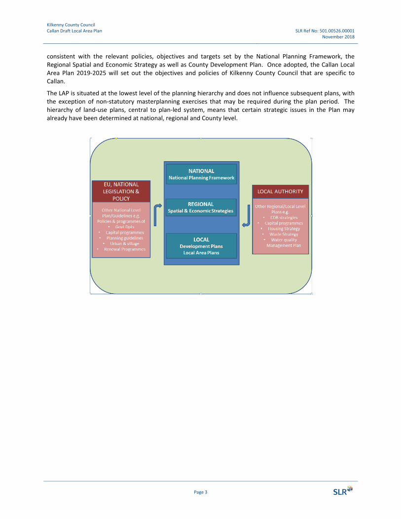
consistent with the relevant policies, objectives and targets set by the National Planning Framework, the Regional Spatial and Economic Strategy as well as County Development Plan. Once adopted, the Callan Local Area Plan 2019‐2025 will set out the objectives and policies of Kilkenny County Council that are specific to Callan.
The LAP is situated at the lowest level of the planning hierarchy and does not influence subsequent plans, with the exception of non‐statutory masterplanning exercises that may be required during the plan period. The hierarchy of land‐use plans, central to plan‐led system, means that certain strategic issues in the Plan may already have been determined at national, regional and County level.

Kilkenny County Council Callan Draft Local Area Plan SLR Ref No: 501.00526.00001
November 2018
Page 4
2.0 Callan in Context
2.1 Area Identity
Callan is one of the four district towns in Co. Kilkenny, located to the south‐west of county. The town is located 16 km south‐west of Kilkenny City, 24 km from Carrick on Suir, 27 km from Clonmel and 56 km from Waterford City. Callan is well connected by road, with the N76 traversing on the west side of the town centre making it accessible to Kilkenny City, and by extension with the M9 to Dublin.
Callan is an historic town and its characteristic medieval core developed during the beginning of 13thcentury. This historic core encompasses Mill Street, Upper and Lower Bridge Streets, Coyne Street, Mill and Clodine Lane is designated as an Architectural Conservation Area. The streets are narrow and winding and centre primarily on Upper and Lower Bridge Street which contain a variety of traditional shop fronts. There is a distinct cross pattern to the street layout at the top of Bridge Street Upper, where the four most significant streets converge on one central point. This point is considered by many to be the centre of Callan.
The King’s River traverses the town from east‐west and two key public spaces along the shore of this river showcase some particularly fine features of architectural and cultural heritage; an Anglo‐Norman motte and the Augustine Abbey.
A significant extension to the town was constructed in the 19th Century south of the historic core with more generous dimensions, a contrast to the narrow streets close to the river. This houses a group of landmark public administration buildings and represents the civic quarter of Callan, with larger plots and classical style facades.
2.2 Demographic and Socio‐economic Characteristics
According to Census 2016, Callan has a population of 2,475, which is an increase in resident population of just over 6% since the previous 2011 Census. The most common age cohorts resident in the town between 35 and 44 years old, representing 17.5% of the resident population (an increase of 1% since 2011). 87% of the resident population are Irish nationals – the same proportion as in 2011. In terms of household composition, two‐person households represent the largest group at 39%. The most frequent family units with children are those with 1 or 2 children making up 82%.
In terms of housing, Census 2016 also records that 44% of all permanent private households built since 1920 were built during the years 2001‐2010 – a higher proportion than the national average of just over 25%. According to Census 2016 vacant housing comprises just over 10% of total housing, which is a decrease of 2.9% since Callan Local Area Plan 2009‐2020 was published.
In relation to employment, Callan had a 9% unemployment rate in 2016 compared to a national average7%. Approximately 15% of the population were retired at the time of the 2016 census. Managerial and technical is the largest workers group, making up 23.5% of all categories. Persons in total working in ‘Professional Services’ is one of the strongest industries in Callan at almost 28% of the total industries, while ‘Commerce and Trade’ comprises 23.5% of all industries. The 2016 Pobal HP Deprivation Index shows Callan Urban with a score of ‐5.87 which is marginally below the national average with three small areas in the town indicating very disadvantaged status. The score is an improvement on the 2011 results which scored Callan at ‐7.16%.

Kilkenny County Council Callan Draft Local Area Plan SLR Ref No: 501.00526.00001
November 2018
Page 5
In terms of educational attainment, Census 2016 records that 25% of the population of Callan had completed the National Framework of Qualifications (NFQ) Level 6 (Higher Certificate) or above. While this is an increase of just over 1% since 2011, it remains well below the State average of 40% in 2016) for this level of educational attainment.
Regarding transport and commuting, 47.5% of people in Callan travelling to work, school or college have a journey time of 15 minutes to 45 minutes; remaining roughly the same level since 2011. Census 2016 records that 76%, of households own either one or two cars. This level of car ownership is reflected in that 60% of those travelling to work, school or college are recorded as using a car while 23% of people travel by foot.
2.2.1 Commercial Profile
Callan provides a range of public services, cultural and natural heritage as well as retail and other commercial services. In terms of business type, analysis of Geodirectory data shows that there are 135 enterprises in total. The most frequent enterprises in Callan are:
‐ Beverage serving activities (9 enterprises),
‐ Hairdressing and other beauty treatment (6 enterprises),
‐ Restaurants and mobile food service activities (6 enterprises),
‐ ‘Other human health activities’ (5 enterprises),
‐ ‘Retail sale in non‐specialized stores with food, beverages or tobacco’ (5 enterprises)
Key retail premises in Callan include grocery/butchers, pharmacies, a Post Office, banks, Credit Unions, hairdressers, funeral homes, in addition to a number of public houses along the main streets. There are few cafés (not located in a public house) located in different parts of the town, but restaurants are less evident. There are also a number of professional services located in Callan, including solicitors, accountants, architects and estate agents.
Callan’s main supermarkets include SuperValu which is situated one of the main streets (Green Street) and Aldi located on the immediate outskirts of the town with direct access from the N76. Both have large car parking areas and are accessible by short walking distances from town centre. Callan has one business park, in the north‐west hosting a mix of mechanical and industrial business. The visitor accommodation in Callan is limited to a few B&B located in around Callan town.
Kilkenny Crystal factory and outlet shop also has its home in Callan and this forms part of the creative craft and design trail of Kilkenny City. The town also has a pottery workshop and hosts the annual town festival Abhainn Rí attracting many visitors.
The farmer‐owned Callan co‐op is based in the town selling hardware as well as agricultural supplies including farmers produce, and offering employment and services the hinterland around Callan.
2.2.2 Vacant Commercial Addresses
Analysis of Geodirectory data shows that Callan has 28 vacant commercial addresses out of a total of 179 commercial addresses – a rate of 16% vacancy for commercial addresses. There are a number of vacant buildings located in prominent areas of the town. These include former retail units, B&B and public houses. Notably, there is a cluster of vacant premises on Bridge Street. The south part of town, Green Street, generally has less vacant shops with a wide array of businesses maintaining street activity.

Kilkenny County Council Callan Draft Local Area Plan SLR Ref No: 501.00526.00001
November 2018
Page 6
2.3 Policy
2.3.1 Ireland 2040 – The National Planning Framework (2018)
The National Planning Framework (NPF) sets the overarching context for planning policy in Ireland and has identified the requirement for growth of approximately one million additional people in Ireland by 2040. This means planning for a substantial increase in the number of people and jobs on the island of Ireland.
For southern region assembly area which includes County Kilkenny this means:
340,000 ‐ 380,000 additional people i.e. a population of almost 2 million.
around 225,000 additional people in employment i.e. 880,000 (0.875m) in total.
Under the objective of ‘Securing Compact and Sustainable Growth’, the NPF states that the physical form of urban development in Ireland is one of our greatest national development challenges. It states that more than anything else, getting the physical form and location of future development right offers the best prospects for unlocking regional potential.
The strategy as set out in the NPF is ‘compact development that focuses on reusing previously developed land. This requires focus on four key areas:
1. The ‘liveability’ or quality of life of urban places; 2. Making the continuous regeneration and development of existing built up areas as attractive and as
viable as greenfield development; 3. Tackling legacies such as concentrations of disadvantage in central urban areas; 4. Linking regeneration and redevelopment initiatives to climate action.
The NPF includes the following national policy objectives which are relevant to the review of the Callan LAP.
National Policy Objectives LAP Response
National Policy Objective 3c: Deliver at least 30% of all new homes that are targeted in settlements other than the five Cities and their suburbs, within their existing built‐up footprints. CSO Footprint
Housing target will be delivered within the existing built‐up footprint
National Policy Objective 4: Ensure the creation of attractive, liveable, well designed, high quality urban places that are home to diverse and integrated communities that enjoy a high quality of life and well‐being.
Mixed, connected and integrated communities.
National Policy Objective 6: Regenerate and rejuvenate cities, towns and villages of all types and scale as environmental assets, that can accommodate changing roles and functions, increased residential population and employment activity and enhanced levels of amenity and design quality, in order to sustainably influence and support their surrounding area.
Improve resilience and design to accommodate change
National Policy Objective 7: Apply a tailored approach to urban development, that will be linked to the Rural Regeneration and Development Fund.
Focus on opportunities to reversing the stagnation or decline of many smaller urban centres, by identifying strategic enabling projects that can be funded through the Rural Regeneration and Development Fund.
National Policy Objective 54: Reduce our carbon footprint by Focus on opportunities to reduce the

Kilkenny County Council Callan Draft Local Area Plan SLR Ref No: 501.00526.00001
November 2018
Page 7
National Policy Objectives LAP Response
integrating climate action into the planning system in support of national targets for climate policy mitigation and adaptation objectives, as well as targets for greenhouse gas emissions reductions.
demand for energy and use a better mix of low carbon energy sources. Measures to enhance sustainable travel will also reduce the need for travel by car.
National Policy Objective 17;
Enhance, integrate and protect the special physical, social, economic and cultural value of built heritage assets through appropriate and sensitive use now and for future generations
Appropriate conservation policies included in the draft LAP for heritage assets
2.3.2 Regional Spatial and Economic Strategy for the Southern Region
The Southern Regional Assembly published the Issues Paper for its Regional Spatial and Economic Strategy (RSES) in Q1 of 2018 and is currently working on preparing a draft RSES which is due for public consultation in November 2018. The South East Region Planning Guidelines 2010 – 2022 remain in effect until the RSES is adopted.
The principal purpose of the RSES is to support the implementation of the NPF and the economic policies and objectives of the Government by providing a long‐term strategic planning and economic framework for the development of Ireland’s regions.
The Issues Paper for the Regional Spatial and Economic Strategy for the Southern Region promotes the region’s significant potential for the development of an effective counter‐balance to the Greater Dublin Area, driven by its regional cities, county towns and its broad rural base supported by an established and resilient network of smaller towns and villages.
Key future planning and development and place‐making policy priorities for the Southern Region include:
Emphasis on consolidating the development of places that grew rapidly in the past decade;
Preparing and implementing a regional rejuvenation priorities programme, to shape and inform delivery of the Regeneration and Development Fund and identifying significant ready‐to‐go city, rural town and village and rural rejuvenation priorities harnessing publicly owned land and other assets that are not being used actively.
Harnessing the potential of the region in renewable energy terms across the technological spectrum;
Developing a more integrated network of greenways, blueways and peatways to support the diversification of rural and regional economies and promote more sustainable forms of travel and activity based recreation.
Kilkenny’s District Towns of Callan, Castlecomer, Graiguenamanagh and Thomastown, along with the smaller towns and villages, have significant growth potential in areas such as agriculture, food, energy and tourism. These towns have the capacity for population growth utilising planned land use and placemaking principles.
2.3.3 The Kilkenny County Development Plan 2014 ‐ 2020
The adopted development plan for County Kilkenny is the Kilkenny County Development Plan (CDP) 2014 ‐2020The review of the Kilkenny CDP commenced in April 2018. The following six key issues to be addressed by the CDP are:
Economic recovery; positioning of the county to avail of any economic upturn

Kilkenny County Council Callan Draft Local Area Plan SLR Ref No: 501.00526.00001
November 2018
Page 8
Underpinning the settlement hierarchy within the county and compliance with the requirements of the Regional Planning Guidelines through the core strategy.
Renewable energy strategy including wind energy policy
Continued protection of the natural and built heritage
Planning frameworks for smaller towns and villages
Identification of key infrastructure for the County to bolster its development In line with the South East Regional Planning Guidelines, Callan is classified as a District Town in the County’s settlement hierarchy. It is an objective of the Core Strategy of the Kilkenny CDP that District Towns
“… will in so far as practical be self‐sufficient incorporating employment activities, sufficient retail services and social and community facilities”.
In terms of economic development, the Kilkenny CDP has as its objectives for District towns:
“To ensure the sustainable development of the District towns in the County to achieve their target populations and enhance their capacity to attract new investment in employment, services and public transport for the benefit of their own populations and that of their rural hinterlands.”
To promote a diverse and sustainable local economy through the designation of sufficient lands for employment related uses, including facilities, to promote SME growth through the local area plans for the District towns.”
2.3.4 National Policy Requirements
In addition to the introduction of the National Planning Framework and RSES, a number of new national policy requirements and legislative changes have been introduced since the preparation of the previous Callan Local Area Plan in 2009.
2.3.5 Smarter Travel: A Sustainable Transport Future, 2009‐ 2020
SmarterTravel, A Sustainable Transport Future, is the transport policy for Ireland for the period 2009‐2020.This document sets out the transport policy for Ireland which, in addition to prudent investment in new infrastructure, sets out necessary steps to ensure that people choose more sustainable transport modes such as walking, cycling and public transport. This key national policy has sustainability at its core and clearly indicates that future population and economic growth will have to take place predominantly in sustainable, compact urban and rural areas which discourage dispersed development and long commuting.
2.3.6 Interim Guidelines for Planning Authorities on Statutory Plans, Renewable Energy and Climate Change – July 2017
These interim guidelines state that local authority development plans are a critical part of translating overall national policy on energy, renewable energy and wind energy in a manner that supports the achievement of Ireland’s international obligations relating to climate change and renewable energy, and taking account of local circumstances. As provided for in section 10(2) (n) of the Planning and Development Act (2000), as amended, (the Act), development plans are required to include objectives to mitigate against climate change and reduce reliance on fossil fuels.
2.3.7 National Climate Change Policy,2013
The extent of the challenge to reduce Green House Gas (GHG) emissions in line with our International and EU obligations is reflected in the National Policy Position on Climate Action and Low Carbon Development (2014) and the Climate Action and Low Carbon Development Act 2015. The National Policy Position establishes the

Kilkenny County Council Callan Draft Local Area Plan SLR Ref No: 501.00526.00001
November 2018
Page 9
fundamental national objective of achieving transition to a competitive, low carbon, climate‐resilient and environmentally sustainable economy by 2050. ‘ It clarifies the level of GHG mitigation ambition envisaged; and establishes the process to pursue and achieve the overall objective. Specifically, the National Policy Position envisages that policy development will be guided by a long‐term vision based on:
• an aggregate reduction in carbon dioxide (CO2) emissions of at least 80% (compared to 1990 levels) by 2050 across the electricity generation, built environment and transport sectors
• in parallel, an approach to carbon neutrality in the agriculture and land‐use sector, including forestry, which does not compromise capacity for sustainable food production.
2.3.8 The National Mitigation Plan, 2017
The measures proposed by the National Mitigation Plan lay the foundations for transitioning Ireland to a low carbon, climate resilient and environmentally sustainable economy by 2050. The Plan includes over 100 individual actions for various Ministers and public bodies to take forward as we move towards implementation. Chapter 4 outlines proposals to ‘Decarbonise the Built Environment’, with the overall objective of use less energy and for most of the energy to come from low or zero‐carbon fuels. This can be achieved by ensuring that new buildings are low or “nearly zero emission” standard and energy efficiency upgrades, known as retrofits, are carried out with respect to the existing building stock. The mitigation plan states that ‘as well as expecting buildings to consume much less energy, the mix of fuels providing that energy should be transitioning to a much lower carbon content.’
2.3.9 National Adaptation Framework, Planning for a Climate Resilient Ireland, 2018
Ireland's first statutory National Adaptation Framework (NAF) was published in January 2018. The NAF sets out the national strategy to reduce the vulnerability of the country to the negative effects of climate change. The NAF was developed under the Climate Action and Low Carbon Development Act 2015. In relation to the ‘Built Environment and Spatial Planning’ it states that
‘It is clear that climate change considerations need to be taken into account as a matter of course in planning‐related decision making processes and that the deepening of adaptation considerations in the planning and building standards processes is considered the most appropriate way of increasing the resilience of the built environment.
Integrating climate considerations into decision making should ensure that inappropriate forms of development in vulnerable areas are avoided and compact development in less vulnerable areas is promoted. Other considerations include the spatial implications of water stress. Land use policies may also facilitate the conversion or maintenance of land at risk of flooding to less vulnerable uses (e.g. parks, gardens and open spaces for natural habitats, etc.). Local Authorities are required to prepare Adaptation Strategies and the Guidelines2 for their preparation recommend that, once approved, strategies should be used to assess the adaptation fitness of spatial plans and ensure that climate change adaptation considerations are mainstreamed into the process. The Adaptation Strategy for Kilkenny is currently in preparation.
______________________
2The Local Authority Adaptation Strategy Development Guidelines (2016)

Kilkenny County Council Callan Draft Local Area Plan SLR Ref No: 501.00526.00001
November 2018
2.3.10 Vacant Site Levy
The Urban Regeneration and Housing Act 2015 introduced the Vacant Site Levy as a tool that can be used by local authorities, in combination with other incentives, to achieve rejuvenation priorities of the Region as set out in the NPF. The Act enables local authorities to provide, as a specific objective in County development plans and local area plans, for the development, redevelopment and reuse of vacant sites in specific locations within urban areas where they consider it to be beneficial towards securing the objectives of the relevant core strategy, housing strategy and retail strategy of development plans.
The Levy is an integral part of the development planning process to incentivise the development of vacant or idle sites identified by planning authorities as “regeneration land” or “residential land”, with a view to bringing such sites into beneficial use. It can be imposed by planning authorities under certain conditions in designated areas where sites remain vacant and site owners/ developers fail to bring forward reasonable proposals, without good reason, for the development/reuse of such property in line with the provisions of the relevant local area or development plan.
The draft Callan LAP promotes, encourages and facilitates the appropriate development of sites identified as
“regeneration land” and “residential land” in order to prevent adverse effects on existing amenities in such areas, in particular as a result of
the ruinous or neglected condition of any land
Urban blight or decay
Anti‐social behaviour, or a shortage of habitable houses or of land suitable for residential use or a mixture of residential and other uses
The levy can be applied on land designated as either “residential” or “regeneration”. For the purposes of implementing the levy, the following zones are designated:
Residential: Existing Residential, New Residential & Low Density Residential
Regeneration: General Business, Industrial
These zones will be examined to determine if there are sites where the Vacant Site Levy is applicable under the provisions of Urban Housing and Regeneration Act 2015 and all associated regulations and guidance.
2.4 Other Plans and Policies
2.4.1 Kilkenny Local Economic and Community Plan 2016 ‐ 2021
A Local Economic and Community Plan (LECP) for Kilkenny was published in February, 2015 and provides a road map for the development of our county to 2021. One of the main objectives of the LECP is to ensure the effective co‐ordination of publicly funded programmes. As a statutory plan, the LECP provides a blueprint for local and community development funding invested in County Kilkenny over the plan period. The themes and
Strategic Objective 1: It is an objective of Kilkenny County Council to identify the individual vacant sites in the town for regeneration and housing and establish and maintain a register of vacant sites (entitled the vacant sites register) in the plan area for the purpose of the Vacant Site Levy (Urban Regeneration and Housing Act 2015).

Kilkenny County Council Callan Draft Local Area Plan SLR Ref No: 501.00526.00001
November 2018
Page 11
goals of the Kilkenny LECP process align with national and European objectives and themes. In total, 13 high‐level goals have been identified for County Kilkenny, each with specific sustainable objectives and a range of related actions.
2.4.2 Framework for Town Centre Renewal, 2017
A framework for Town Centre Renewal was drafted in response to the impact that the recession had on the retail and wholesale sector. A challenge identified by the Forum is the need to develop a coherent and collaborative approach to implementing town centre renewal. The Action Plan, included in the Framework, provides a structure for collaborative partnerships among stakeholders to achieve successful town centre renewal. It involves three key steps:
Step 1 ‐ Stakeholder Engagement and Health Check: Understanding a town and the key stakeholders, identifying strengths and weaknesses, challenges and opportunities.
Step 2 ‐ Establish a Town Centre Management Partnership or “Town Team”: This will have the support of all the stakeholders involved at step one.
Step 3 ‐ Prepare and implement a Town Centre Plan: The Plan should clearly express the vision for the town, the actions required, and who is responsible for what.
Steps 1 and 2 have been completed for Callan, with health check complete and town team established. The preparation of the Callan Town Renewal Plan is now underway. The purpose of this plan will be to
support the implementation of the Town and Village Renewal Scheme 2017
to deliver economic impact in towns and villages across the country;
Identify further funding streams for town centre renewal and for funding specific projects;
It is envisaged that the statutory Callan LAP will support the Town Centre Renewal Plan and enable a coordinated approach to the delivery of a successful place making strategy.
2.4.3 Callan Town Centre Health Check
At the time of writing this Draft LAP, the Callan Town Centre Health Check is awaiting publication. The findings of the study have identified measures for further action which have been framed around seven core themes:
1. Public Realm Improvements 2. Traffic Management Enhancements 3. Promotion of Local Skills, Produce and Enterprise 4. Recreation and Amenities Enhancement 5. Community Development and Engagement 6. Tourism, Culture and Heritage Development 7. Branding and Marketing
2.4.4 Draft Callan Town Improvement Plan, 2018
This Draft Callan Town Improvement Plan has been developed by the Callan Town Team. It is a Draft Plan, pending public consultation and any revisions or amendments that are required to be made following the public consultation process. The draft Plan identifies a schedule of actions which are intended to be included in the final Callan Town Improvement Plan. The actions relate to;
Public Realm improvement and Residential Regeneration
Traffic Management Enhancements
Tourism, Culture and Heritage Development
Recreation and Amenity Enhancements
Community Development and Engagement
Branding and Marketing

Kilkenny County Council Callan Draft Local Area Plan SLR Ref No: 501.00526.00001
November 2018
Promotion of Local Skills Produce and Enterprise
Key outcomes identified include:
Bridge Street /Mill Street Regeneration Strategy and Master plan.
Fair Green Regeneration
Motte Fields Amenity Area
Mobility Management Plan
2.4.5 Rural Regeneration and Development Fund
As part of Project Ireland 2040, the Government has committed to providing an additional €1 billion for a new Rural Regeneration and Development Fund over the period 2019 to 2027. This fund is designed to provide investment to support rural renewal for suitable projects in towns and villages with a population of less than 10,000 and outlying areas. It will be administered by the Department of Rural and Community Development. The purpose of the fund will be to support
the objectives of the National Planning Framework, and in particular to achieve ‘Strengthened Rural Economies and Communities’ – one of the National Strategic Outcomes of the NPF
coordinated and integrated projects between Government Departments, State agencies, Local Authorities, other public bodies, communities and, where appropriate, philanthropic funders and/or the private sector, which will have an impact on sustainable economic and social development in rural areas.
Initial funding of €315 million is being allocated on a phased basis and will be awarded through a competitive bid process. Under the first call for proposals application are invited under two categories:
Category 1: “Ready‐to‐Go” proposals, or initial phases of projects which can be commenced in 2019, which have the necessary consents (e.g. planning) in place, are at an advanced stage of design, are in a position to satisfy value‐for‐money requirements in accordance with the Public Spending Code, and are procurement‐ready.
Category 2: Proposals that have clear potential and quantifiable objectives but require further development to enable them to be potentially submitted as Category 1 proposals in subsequent funding calls.
Four applications have been made by Kilkenny County Council for the funding of the following projects under the Rural Regeneration and Development Fund.
Bridge Street/Mill Street Regeneration and Mobility Management Plan
The Friary Conservation Plan
Callan Motte Fields Amenity
Callan Fair Green Re‐development
2.4.6 Town Centre Living ‐ Pilot Project
Callan has recently been awarded funding by the Department of Rural and Community Development to develop and test models for town centre living. The primary objective of the pilot initiative is to encourage more people to opt to live in town centres in rural Ireland. The initiative complements the Town and Village Renewal Scheme and the Rural Regeneration and Development Fund which will provide an opportunity to take the emerging ideas to implementation stage. It also compliments the strategic aims of the Draft LAP.
Strategic Objective 2: It is an objective of Kilkenny County Council to support the delivery of projects submitted as funding applications to the Rural Regeneration and Development Fund.
Strategic Objective 3: It is an objective of Kilkenny County Council to support the development and implementation of the Town Centre Living – Pilot Project.

Kilkenny County Council Callan Draft Local Area Plan SLR Ref No: 501.00526.00001
November 2018
Page 13
2.4.7 Kilkenny Age Friendly County Strategy 2017 – 2022
People are living longer and healthier lives. According to the Department of Health by the year 2036 the number of older people aged 65 and older living in Ireland, is expected to increase by 250%. As stated in the Kilkenny Age Friendly County Strategy, Kilkenny County Council will ensure that Age and Dementia Friendly design and planning principals are embedded in all local authority planning and development.
Kilkenny’s planning and design policies will continue to be inclusive of age friendly designs and consistent with established best practices. KCC will also ensure that successful age friendly spaces, seating and parking are introduced throughout the county. This will also include age and dementia signage in all public buildings.

Kilkenny County Council Callan Draft Local Area Plan SLR Ref No: 501.00526.00001
November 2018
3.0 Vision and Strategic Objectives
3.1 Key Issues for the Callan LAP 2019‐2025
In reviewing newly adopted national as well as up‐to‐date baseline statistics in relation to Callan, the conclusions of the 2018 review suggest the need to focus on:
Town centre regeneration and addressing vacancy and dereliction within the historic core;
Promoting low and zero carbon technologies to meet the heating and electricity demand of new development;
Improving north south connections and pursuing a sustainable transport agenda, focusing on improving facilities for walking and cycling
Improving the quality and usability of existing open space,
Continued consolidation of development within the town boundary;
Continued support of the arts, creative, voluntary and community sectors;
Ensuring basic infrastructure and services is in place to maintain high environmental quality and services for residents and businesses;
Addressing legacy issues in relation to unfinished housing estates/ development;
Improving public access to and management of historic and cultural assets, including but not limited to
o St Mary’s Church,
o Bridge Street,
o The Motte Meadow,
o the Friary Complex, and
o The Callan Workhouse.

Kilkenny County Council Callan Draft Local Area Plan SLR Ref No: 501.00526.00001
November 2018
3.2 A Vision for 2025
The following vision for the plan period 2019‐2025 is proposed:
‘By 2025, Callan will be a vibrant low carbon district town approaching a population of 2,800 people supported by a consolidated town centre and employment centred on retail, creative industries, arts, tourism and community service sectors as well as a strong local industrial sector. Enhanced north – south connections for pedestrians and cyclists will be provided. Focusing on Bridge Street, these measures will be combined with a range of traffic management proposals including additional off street parking which will improve vitality of the town centre and Bridge Street in particular as well as supporting healthy living. Historic landmarks and a series of improved public spaces will provide a focus for new activities. A masterplanning approach to design will create high quality sustainable low carbon and adaptable residential areas that are well integrated with existing neighbourhoods. All new development will respect and enhance the character and quality of the existing built and natural environment in Callan.’
4.0 Core Strategy & Zoning
A ‘Core Strategy’ shows that the development objectives in the Local Area Plan are consistent, as far as practicable, with the County Development Plan as well as national and regional development objectives set out in the National Planning Framework and Regional Spatial and Economic Strategy. This chapter sets out the core strategy for the Callan Local Area Plan 2019‐2025 and demonstrates consistency with Kilkenny County Development Plan 2014 ‐2020 as well as the National Planning Framework, and in the absence of RSES, the population projections as set out in the Implementation Roadmap for the National Planning Framework.
The core strategy for Callan LAP is to:
4.1 Population Trends
The proportion of the County Kilkenny population living in urban areas is gradually increasing. Callan is designated as a district town and its population is growing in line with this trend. Of all rural towns and villages
To provide for the proportionate growth of Callan maintaining its 2.5% of the County’s population allocation to 2026 in accordance with the National Planning Framework and the County Development Plan Settlement Strategy.

Kilkenny County Council Callan Draft Local Area Plan SLR Ref No: 501.00526.00001
November 2018
Page 16
in Kilkenny, Callan along with Thomastown are recording the highest levels of growth in the County. Census records provided in Table 2 shows consistent levels of growth in Callan and the wider County since 1996. The ambition for Callan is to maintain Callan’s proportionate share of the county’s population projection.
Table 1 Census Records from 1996‐2016& Population Projection to 2026
Population 1996 2002 2006 2011 2016 Population Projection ‐
2026
Callan 1,224 1,325 1,771 2,330
2,475 2,750
Kilkenny County
75,336 80,399 87,558 95,419 99,118 110,000
4.1.1 Kilkenny County Development Plan 2014‐2020
It is a strategic aim of the Kilkenny County Development Plan 2014‐2020, to implement the provisions of the Regional Planning Guidelines and to target the growth of Kilkenny City, Ferrybank/Belview, the District Towns, the other settlements in the hierarchy and rural areas to advance sustainable development.
In terms of the settlement hierarchy, the Core Strategy set out in the County Development Plan identifies Callan as a district town. The role for Callan as a district town is identified as follows:
In general, these District Towns have well developed services and community facilities and have the capacity to accommodate additional growth (subject to certain physical infrastructural investments).
The CDP also states that ‘In the promotion of development generally, the Local Authority will focus on opportunities for the redevelopment and renewal of areas in need of regeneration, whether urban or rural. Objective 3E of the CDP states
To ensure that the District Towns will in so far as practical be self‐sufficient incorporating employment activities, sufficient retail services and social and community facilities.
The recently published National Planning Framework and following Roadmap (July 2018) re‐affirm the approach for towns in the range of 1,500 – 5,000 population allocating proportionate growth. The population for County Kilkenny in the NPF Roadmap is 110,000 to 2026. This figure has been used as the basis for projecting Callan’s population up to 2026. (See Table 1 above)
Kilkenny County Council Callan Draft Local Area Plan SLR Ref No: 501.00526.00001
November 2018
Page 17
4.2 Approach to Residential Zoning
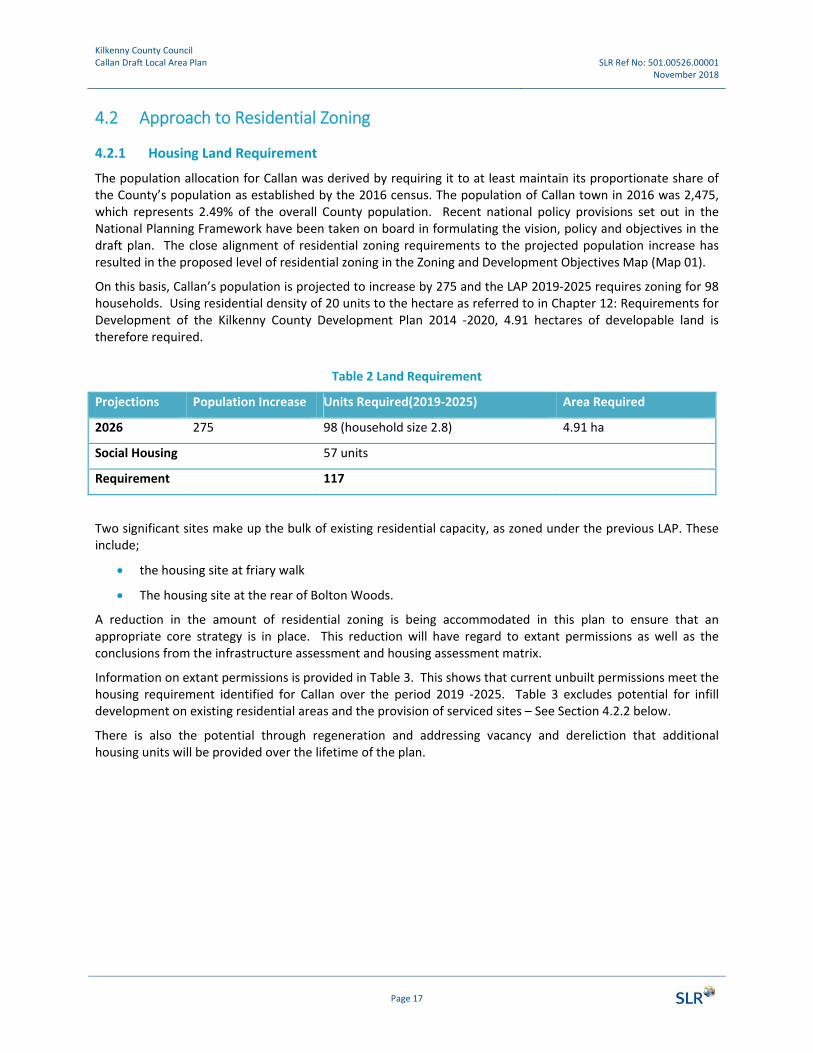
4.2.1 Housing Land Requirement
The population allocation for Callan was derived by requiring it to at least maintain its proportionate share of the County’s population as established by the 2016 census. The population of Callan town in 2016 was 2,475, which represents 2.49% of the overall County population. Recent national policy provisions set out in the National Planning Framework have been taken on board in formulating the vision, policy and objectives in the draft plan. The close alignment of residential zoning requirements to the projected population increase has resulted in the proposed level of residential zoning in the Zoning and Development Objectives Map (Map 01).
On this basis, Callan’s population is projected to increase by 275 and the LAP 2019‐2025 requires zoning for 98 households. Using residential density of 20 units to the hectare as referred to in Chapter 12: Requirements for Development of the Kilkenny County Development Plan 2014 ‐2020, 4.91 hectares of developable land is therefore required.
Table 2 Land Requirement
Projections Population Increase Units Required(2019‐2025) Area Required
2026 275 98 (household size 2.8) 4.91 ha
Social Housing 57 units
Requirement 117
Two significant sites make up the bulk of existing residential capacity, as zoned under the previous LAP. These include;
the housing site at friary walk
The housing site at the rear of Bolton Woods.
A reduction in the amount of residential zoning is being accommodated in this plan to ensure that an appropriate core strategy is in place. This reduction will have regard to extant permissions as well as the conclusions from the infrastructure assessment and housing assessment matrix.
Information on extant permissions is provided in Table 3. This shows that current unbuilt permissions meet the housing requirement identified for Callan over the period 2019 ‐2025. Table 3 excludes potential for infill development on existing residential areas and the provision of serviced sites – See Section 4.2.2 below.
There is also the potential through regeneration and addressing vacancy and dereliction that additional housing units will be provided over the lifetime of the plan.

Kilkenny County Council Callan Draft Local Area Plan SLR Ref No: 501.00526.00001
November 2018
Page 18
Table 3 Pipeline Supply/ Extant Permissions
Site Size (ha) Planning History Capacity
Friary Walk 4.21 Planning Register Ref: 10/458 / 16/186
65 units
Rear of Bolton Wood 1 / Kingscourt
1.73 Planning Register Ref: 18/124
53 units
Part VII Local Authority Housing Development
38 units
Total in Extant Permissions
156 units
Total – Extant Permissions
Infrastructural Assessment
In accordance with the requirement of the National Planning Framework (NPF), an Infrastructure Assessment (IA) has been completed for the plan area. This Infrastructural Assessment is based on the potential for delivery of the required services and/or capacity to support new development and is also aligned with the approved infrastructural investment programme of the relevant delivery agency(ies) or be based on a written commitment by the relevant agency(ies) to provide the required infrastructure within a specified timescale.
The NPF requires a two‐tier approach to the Infrastructure Assessment which is set out as follows:
Tier 1: Serviced Zoned Land; comprising lands that are able to connect to existing development services, i.e. road and footpath access including public lighting, foul sewer drainage, surface water drainage and water supply, for which there is service capacity available, and can therefore accommodate new development.
Tier 2: Serviceable Zoned Land; comprises lands that are not currently sufficiently serviced to support new development but have potential to become fully serviced within the life of the plan.
Further statutory guidance is awaited under Section 28 of the Planning and Development Act and the IA methodology is therefore not fully developed. Notwithstanding this absence of statutory guidance, land proposed for residential zoning within this Draft LAP was considered against the Tier 1 and Tier 2 Infrastructure Assessment criteria set out in the NPF. The plan relied on a traffic light system (red, amber and green) to identify lands that are most suitable according to the tiered approach and in that way aims to align the zoning with the investment priorities of the agency. The assessment was completed as a desk based study and currently excludes an estimate in relation to the full cost of delivery of the required infrastructure.
The Infrastructure Assessment however only addresses a single site suitability criteria, which has to be considered in combination with further criteria to determine suitability when prioritising land for zoning. The Infrastructure Assessment was therefore included in a higher order Housing Lands Assessment Matrix, which includes further high level criteria such as “Compact Growth” and “Physical Suitability”. This assessment matrix is again based on a traffic light system, which, when considering the various elements of each criterion, is considered the most suitable methodology.

Kilkenny County Council Callan Draft Local Area Plan SLR Ref No: 501.00526.00001
November 2018
4.2.2 The Provision of Serviced sites
The National Planning Framework states that it is National Policy (Objective 18b) to ‘Develop a programme for ‘new homes in small towns and villages’ with local authorities, public infrastructure agencies such as Irish Water and local communities to provide serviced sites with appropriate infrastructure to attract people to build their own homes and live in small towns and villages’ In accordance with this policy, an area of land has been set aside for serviced sites within the Local Area Plan boundary. It is expected that this area will accommodate approximately 20 units. It is recommended that a masterplan be prepared for this site in order to maximise design quality. Therefore, in addition to meeting the housing land requirement of 4.91 ha, the LAP also includes provision for serviced sites which is consistent with National Policy Objective 18b of the National Planning Framework.
Table 4The Provision of Serviced sites
Site Size Capacity
Rear of Bolton Wood 2 2.8ha 20 – low density
4.2.3 Social Housing Provision
It is important to note that the LAP will also make provision for social housing within the town, through Part V, Local Authority and Voluntary Housing developments. Following consultation with the Housing Section of the Council, it is estimated that ca. 57 units are required for people who are currently resident in the town and therefore do not represent population growth in the context of this Local Area Plan. Units contributing towards meeting the social housing for such persons already living in Callan will not be counted as part of the proposed 98 units but will be added to same. It is envisaged that these units will be provided by means of an existing Part VIII Council development, whereby 38 units are already under construction and through the delivery of Part 5.
4.3 Zoning Objectives
This Draft LAP should be read in conjunction with the Zoning and Development Objectives Map (Map 01), Figure 1 overleaf which sets out Kilkenny County Council’s objectives for the use and development of land within Callan in accordance with local need, the vision and population projections of the Draft Plan.
Recent national policy provisions set out in the National Planning Framework have been taken on board in formulating the vision, policy and objectives in the draft plan. The close alignment of residential zoning requirements to the projected population increase has resulted in the proposed level of residential zoning in the Zoning and Development Objectives Map (Map 1).
Strategic Objective 4: It is an objective of Kilkenny County Council to implement land use zoning objectives for the plan area as set out in Map 01 and Appendix 1 of the Draft Plan.

Kilkenny County Council Callan Draft Local Area Plan SLR Ref No: 501.00526.00001
November 2018
Page 20
Figure 1 Zoning and Development Objectives Map
4.4 Strategic Objectives
The objectives within this Local Area Plan are closely aligned with strategic outcomes of the National Planning Framework. The relevant strategic outcomes are the strengthening of rural economies and communities, the delivery of compact growth through infill development, improved liveability and quality of life, economic development and job creation, sustainable modes of travel and the transition to a low carbon and climate resilient society.
4.5 Development Strategy and Active Land Management
The Development Strategy is to provide a planning framework which will support the economic development of Callan based on local strengths including heritage and tourism, promote the conservation of its natural and built heritage, consolidate the town within the existing plan boundary making more efficient use of land and existing infrastructure, facilitate the sustainable growth and development of the town through the creation of high quality and permeable developments and identify opportunities for the delivery of supporting infrastructure, facilities and amenities to support quality of life for existing and future populations.
The key considerations underlying this strategy are as follows:
• National/Regional/Local Policy Context (i.e. the NPF, RSESs, County Core Strategy etc.) • Demographic and socio‐economic trends • Assessment of need for housing
Kilkenny County Council Callan Draft Local Area Plan SLR Ref No: 501.00526.00001
November 2018
Page 21
• Infrastructure Assessment • Flood Risk Assessment • Supporting infrastructure (social, community and commercial, both existing and planned) • Physical suitability • Environmental policy and constraints (ground and surface water quality, flooding, etc.) • The need to protect the towns significant built and natural heritage • The sequential approach ‐ an established planning principle which implies that zoning and
development should prioritise the town centre.
The proposed development strategy is based on the principles of sustainable development as outlined above together with a policy of Active Land Management, which aims to ensure that development land actually comes into use as anticipated in the development plan in tandem with support infrastructure. This approach is supported by application of the vacant sites levy, the Derelict Sites Act and other initiatives by the Council through its housing and community sections.
4.6 Residential Capacity
Indicative residential density standards for the Plan are set out below. It is important to note that these are not prescribed residential density standards; rather they are indicative of what densities would be acceptable at various locations in the plan area. Higher densities must not be achieved at an unacceptable amenity cost to surrounding dwellings and to residents of the proposed development.
• Existing and New Residential: Assumed 20 units per hectare. This zoning allows for new residential development and other services incidental to residential development and reflects the densities which exist in existing housing developments at these locations. While housing is the primary use in this zone, childcare facilities and recreation can also be considered.
• Low Density Residential: Assumed 10 units per Ha. This zoning allows for new residential development at a lower density and services incidental thereto. This zoning reflects the historic densities which exist away from the town centre. While housing is the primary use in this zone, childcare facilities, nursing homes, independent/semi‐independent living units for older people and recreation can also be considered.
This LAP proposes to zone an additional 4.9 hectares of land for new residential development, spread between two residential sites. Based on these density assumptions there is considerable capacity for residential development both as infill development and greenfield development proposed under the ‘new residential’ zoning objective.
4.6.1 Vacant Sites
In 2016, the total housing stock in County Kilkenny was 39,226, of which vacant households (excluding holiday homes) numbered 2,995. In the same year in Callan the total housing stock was 1,032, of which vacant households (excluding holiday homes) numbered 107. In 2016 the percentage of vacant households to housing stock was 7.6% and 10.4% for Kilkenny City and Callan respectively. (Census 2016, CSO)
4.6.2 Commercial Vacancy
Callan town has a wide range of businesses and analysis of Geodirectory data3 shows that there are 135 enterprises in total. According to Geodirectory data dated Q4, 2017, the commercial vacancy rate for Callan
______________________
3https://www.geodirectory.ie/What‐is‐Geodirectory.aspx

Kilkenny County Council Callan Draft Local Area Plan SLR Ref No: 501.00526.00001
November 2018
was 15%. Town centre viability is an issue of concern across the country. The national figure was 13.5% in Q2 2017 with a rate of 12.2% at County level recorded at that same period.
4.7 Residential Development Objectives
RD1: It is a policy of the Council to ensure that sufficient zoned land is available at appropriate locations in Callan to satisfy the housing needs of the town over the period of the plan.
RD2: To make provision for serviced sites with appropriate infrastructure to enable people build their own homes.
RD3: To implement the Vacant Sites provisions of the Urban Regeneration and Housing Act 2015 as amended.

Kilkenny County Council Callan Draft Local Area Plan SLR Ref No: 501.00526.00001
November 2018
4.8 Residential Development Management Objectives
RD DMO 1: In accordance with policies set out in the National Planning Framework, it is an objective of Kilkenny County Council to encourage the appropriate redevelopment of brownfield and infill sites for residential uses within the LAP boundary subject to compliance with the relevant development management standards as set out in the County Development Plan. RD DMO 2: To ensure that a good mix of housing types and sizes is provided to meet the future needs of the population of the town.

Kilkenny County Council Callan Draft Local Area Plan SLR Ref No: 501.00526.00001
November 2018
Page 24
5.0 Town Centre, Economic Development and Employment
Section 4.6.3 of the County Development Plan refers to District Towns in the context of economic development. It states that
‘District Towns perform an important role in driving development in the County and have much potential that can be capitalised upon. Indigenous industry and SME’s are important to these areas. Their strengths lie in their capacity to accommodate employment, residential and other functions on the basis of their comparative advantage in terms of lower costs and a quality of life which is attractive to many people.’
The following objectives of the CDP are relevant to the strategy for economic development and employment:
4J To ensure the sustainable development of the District towns in the County to achieve their target populations and enhance their capacity to attract new investment in employment, services and public transport for the benefit of their own populations and that of their rural hinterlands.
4K To promote a diverse and sustainable local economy through the designation of sufficient lands for employment related uses, including facilities, to promote SME growth through the local area plans for the District towns.
The economy in Callan is predominantly based on service and industrial sectors with a number of commercial operators in the town centre and industrial employers at Westcourt, on Mill Street and in Callan Industrial Estate in Castletobin just outside the town boundary. General business commercial activity remains focused on Green Street and to a lesser extent Upper and Lower Bridge Street. Since the adoption of the 2009‐2015 Local Area Plan, industrial use within the town has largely remained unchanged with the exception of a vacancy arising at the Heiton Buckley Site on Mill Street.
Figures set out in the NPF on Population and Employment in Urban Settlements in the Southern Regional Assembly area suggests that the ratio of jobs to workers in Callan is almost on par. The ratio of 0.923 suggests that availability of employment locally is relatively good. This is a comparatively sustainable position that the LAP should endeavour to maintain.
As estimated in Table 5, maintaining a ratio of 0.923 would require an additional 98 jobs to be provided in Callan over the plan period. Based on an average employment density of 30m2per employee4, this equates to an approximate requirement of 2,940 square metres of space and 2.9 hectares of land. Using a plot ratio of 50%, this would require an addition 5,880m2 or 5.8ha.
A significant area land zoned for industrial uses under the previous 2009‐2015 plan remains undeveloped. At 23.8 hectares in total, not only was this provision excessive in light of the above requirements, infrastructure deficits at certain locations point to a considerable cost of enabling development. Based on these considerations, the zoning allocation for this use has been reduced to 12.65 ha. The 2.29ha does not take into account development capacity within vacant buildings within the existing industrial zoning allocation and also excludes the capacity for employment generating uses, primarily service sector jobs that can be accommodated as part of the town area zoned for general business.
______________________
4Employment Densities Guide, 3rd Edition, 2015.

Kilkenny County Council Callan Draft Local Area Plan SLR Ref No: 501.00526.00001
November 2018
Table 5 Employment Projections
Callan 2016 2025
Population 2,475 2,750 (+11.1%)
Resident Workers 963 1,070 (+11.1%)
Total Jobs 889 987(+11.1%)
Additional jobs +98
Jobs: Resident workers 0.923 0.922
Employment ‐ Objectives
5.1 Town Centre Policies
The Retail Planning Guidelines for Planning Authorities, published in 2012, sets national policy for retail development. The guidelines states that planning for the retail sector must now be more focused on:
the creation of vibrant, quality places, accessible by sustainable transport including for pedestrians and cyclists and within which retailing is an important activity; and
a general presumption against large retail centres located adjacent or close to existing, new or planned national roads / motorways.
The focus of the guidelines is on plan‐led development, addressing the needs of the retail sector by determining a proper evidence base of the need for retail development and ensuring a proactive approach in facilitating the meeting of those needs. The guidelines refer to five key policy objectives that should guide planning authorities in addressing retail development issues in their development planning and development management functions, namely:
EO1: It is an objective of this Local Area Plan to facilitate an increase in employment locally in tandem with the population growth rate. EO2: To support the sustainable development of Callan and enhance its capacity to attract new investment in employment, services and public transport for the benefit of the town and its hinterland. EO3: To promote a diverse and sustainable local economy through the designation of sufficient lands for the promotion of employment related uses including facilities to assist SME growth EO4: To identify the individual vacant sites in the town for regeneration and housing and establish and maintain a register of vacant sites (entitled the vacant sites register) in the plan area. EO5: To encourage the continued improvement of road infrastructure at the Westcourt Industrial Estate to a level that is sufficient to allow the taking in charge of roads and associated infrastructure. EO6: Encourage a diversity of uses in the town centre throughout the day and evening.

Kilkenny County Council Callan Draft Local Area Plan SLR Ref No: 501.00526.00001
November 2018
Page 26
Ensuring that retail development is plan‐led;
Promoting city/town centre vitality through a sequential approach to development;
Securing competitiveness in the retail sector by actively enabling good quality development proposals to come forward in suitable locations;
Facilitating a shift towards increased access to retailing by public transport, cycling and walking in accordance with the Smarter Travel strategy; and
Delivering quality urban design outcomes.
5.1.1 Kilkenny County Development Plan
Callan is currently the third largest centre in the county, after Kilkenny City and Thomastown. Section 4.8.3 of the CDP refers to District Towns and highlights their important role in serving the employment, retail and community needs of their surrounding hinterland.
The 2007 County Retail Strategy identified Callan as a Tier 1 Level 2 Sub County Town centre with middle order convenience and tourism related comparison, retail floorspace considered appropriate. An updated Retail Strategy was published in 2010 and provided as Appendix A to the County Development Plan 2014‐2020.
The following objective of the CDP is also relevant to the strategy for town centre development:
4P To sustain and enhance the vitality and viability of the role and potential of the four District Towns.
The Sequential Approach
The overarching objective of the Retail Planning Guidelines is to enhance the vitality and viability of city and town centres in all their functions through sequential development. Sequential development means that:
Subject to the requirements listed below, only where the applicant can demonstrate and the planning authority is satisfied, that there are no sites or potential sites within a city, town centre or designated district centre should an edge‐of‐centre site be considered. In addition, only in exceptional circumstances where it can be demonstrated that there are no sites or potential sites available either within the centre or on the edge of these centres should an out‐of‐centre site be considered.
In addition to the sequential test, significant proposals for 500 m2 (net) convenience and comparison or more should be considered against the following requirements:
The expenditure capacity within the catchment area, taking account of all extant planning permissions and development proposals/opportunities identified in the City and County Development Plans, including those for the District Towns and other settlements.
The baseline information and capacity/impact assessment is fit for purpose and transparent;
The need to support the long term strategy for city/town centre as established in the Retail Strategy/Development Plan.
The potential to increase employment opportunities and promote economic regeneration.
The potential to increase competition within the area and thereby attract further consumers to the area.
Respond to consumer demand for its retail offering and not diminish the range of activities and services that an urban centre can support.
Cause an adverse impact on one or more city/town centres, either singly or cumulatively with recent development or other outstanding planning permissions sufficient to undermine the vitality or viability of the city/town centre or its wider function in the promotion and encouragement of the arts, culture, leisure, public realm function of the town centre critical to the economic and social life of the community.
Cause an increase in the number of vacant properties in the primary area that is likely to persist in the long term.

Kilkenny County Council Callan Draft Local Area Plan SLR Ref No: 501.00526.00001
November 2018
Page 27
How a shift towards increased access to retailing by public transport, cycling and walking in accordance with the Smarter Travel strategy is facilitated, so that the proposal is easily accessible by all sections of society; and /or links effectively with the town centre/core retail area so that there is likely to be commercial synergy.
The contribution of the development towards site or area regeneration and its contribution in terms of urban design.
The role of the development in improving the competitiveness and retail offer of the city against other competing centres.
5.1.2 Trends in Retail Provision in Callan
Table 8 provides a snapshot of retail floor space provision at intervals since 2007. Since then, and the arrival of Aldi in 2013, there has been a real improvement in the convenience shopping provision in the town.
The story in relation to comparison retailing is less positive, with a continued reduction in floorspace. The drop was particularly pronounced between the 2007 and 2010 surveys. Anecdotally, this suggests that in terms of comparison shopping a combination of the recession, competition from larger centres and online shopping have had an impact on the role of town. It is also likely that the remaining comparison floorspace will face further challenges and that proactive measures will be required to ensure that this role is maintained.
Since the drafting of the updated Retail Strategy in 2010, Aldi has opened in Callan providing an additional net retail area of 990m2. The recent location of Aldi has been an important factor in providing opportunities for linked shopping trips. Additional improvements in footfall and sustainable transport patterns would be further facilitated by better pedestrian and cycling connections along Chapel Lane, which is the main pedestrian route that links Aldi and Green Street.
The role of town centres is evolving and to fill the gap left by the drop in comparison there is an increasing need for Callan to focus on broader objectives around liveability, quality of life and increasing the availability of cultural and leisure activities. Festivals and events also provide an added layer of attractions together with the vibrancy provided by town centre residential neighbourhoods.
Table 6 Retail (Net) Floorspace (m2) in Callan
March 2007 2010 2013 2018
Vacant 569 440 522
Convenience 1,880 1,720
1,453 (net retail area of 990m2 (ALDI))
2,725
Comparison 1,938 1,176
1,139
Total 4,387 3,336 4,386

Kilkenny County Council Callan Draft Local Area Plan SLR Ref No: 501.00526.00001
November 2018
Town Centre/ Retail Objectives
TCO1: Vitality and Viability
It is an objective of the County Retail Strategy and the Local Area Plan to ensure that the vitality and viability of district towns is maintained and enhanced. To achieve this, the Plan will support:
Callan town as the focus of all new retail development in appropriate scale and location;
development that encourages the appropriate re‐use, regeneration of derelict, vacant and underutilised sites and in particular vacancies and underused sites on Green Street, Bridge Street and Mill Street;
the sensitive redevelopment of a number of historic landmark buildings in the town; and
the sequential approach and the assessment criteria, outlined in the County Development Plan, which will be applied to any proposals for retail development within Callan.
TCO2: The County Retail Strategy sets out the role and function of Callan within the retail hierarchy providing guidance on the distribution of new floorspace. The Retail Strategy defines Callan as a Tier 1 Level 2 Sub County Town. The distribution of new floorspace should be linked to Callan’s role in the retail hierarchy for the county and should be appropriate in scale and character to the hierarchical role of the centre. The type of shopping that is appropriate to this level of the hierarchy includes middle convenience and (tourism related) comparison. For retail proposals above the 500m² gross floorspace threshold a retail impact assessment will be required in accordance with County Retail Strategy.
TCO3: Addressing town centre dereliction and vacancy, on upper bridge street in particular will be supported by the preparation of the Bridge Street/Mill Street Regeneration and Mobility Management Plan.
TCO4: It is an objective of Kilkenny County Council to support the work of the town team and assist with the implementation of the town renewal plan and the town centre living pilot project.
TCO5: It is an objective of Kilkenny County Council to prepare an up‐to‐date retail strategy during the lifetime of the plan. The strategy will include current figures on footfall, shopping patterns and expenditure capacity.
TCO6: The delivery of projects/recommendations identified within the town centre health check, where these are compatible with the proper planning and sustainable development of the town.
TCO7: To support the delivery of projects submitted under the Rural Regeneration and Development Fund, where details are compatible with the proper planning and sustainable development of the town. Projects include:
• Bridge Street/Mill Street Regeneration and Mobility Management Plan
• The Friary Conservation Plan
• Callan Motte Fields Amenity
• Callan Fair Green Re‐development
TCO8: Ensuring accessibility of the retail area by a range of transport modes.
TCO9: Prepare a car parking strategy, focusing on the management of existing on street Car Parking on Green Street and the provision of additional off street car parking in and around the town centre.
TCO10: Create an attractive and safe town centre for pedestrians/cyclists.
TCO11: Provide better pedestrian connections along Chapel Lane, which is the main pedestrian route linking Aldi and Green Street.

Kilkenny County Council Callan Draft Local Area Plan SLR Ref No: 501.00526.00001
November 2018
Page 29
5.1.3 The Food Economy
Food is not just as a public health issue or a matter of supporting primary producers but also provides a range of social, cultural and economic benefits. Food and tourism also play a major part in the contemporary experience economy and the links between food and tourism provide a platform for local economic development. Food experiences also help to brand and market destinations, as well as supporting the local culture that is so attractive for tourists. In 2010, the County Food Strategy prepared by the Kilkenny LEADER partnership set out a roadmap for the development of food enterprise culture in Kilkenny. More recently in 2018, Kilkenny was named Ireland's Foodie Destination of the Year.
There are about ten local food producers in and around Callan and there is the potential to develop a centrally located food hub to showcase these products. Powers shop on Bridge Street has been suggested as a possible location.
Under the theme of the ‘Promotion of Local Skills, Produce and Enterprise’ the Callan Town Health Check has also identified the following action to ’Undertake Local Food and Produce Audit’ with the aim of developing a co‐ordinated approach to promotion and collaboration.’

Kilkenny County Council Callan Draft Local Area Plan SLR Ref No: 501.00526.00001
November 2018
Local Food Economy Objectives
LFEO1: It is an objective of Kilkenny County Council to encourage and support
• strong reciprocal relationships between local producers and the local retail/ catering enterprises,
• growth of local shops and restaurants, coffee/ tea shops both opening and offering local food and beverages.
• the integration of the ‘Callan’s’ food culture into the tourism offerings of the County as a whole.
LFEO2: It is an objective of Kilkenny County Council to consider the potential of this sector as part of any emerging regeneration strategy for the town centre, particular where this involves the re use of historic landmark structures.
LFE03: It is an objective of Kilkenny County Council to investigate the feasibility of developing a local food hub on Bridge Street.

Kilkenny County Council Callan Draft Local Area Plan SLR Ref No: 501.00526.00001
November 2018
Page 31
Figure 2‘Powers’ Shopfront – Potential for a niche retail proposal at the heart of historic Callan
Figure 3 Attractive Shop Front on Lower Bridge Street
5.1.4 Regeneration Opportunity Sites
The responsibility for the implementation of policies and objectives contained within this LAP will be dependent on a number of possible funding sources, including EU programmes and grants, the National Government, the County Council and the private sector.
Of particular relevance, is the recently announced €1bn Rural Regeneration and Development Fund which will apply to all settlements and rural areas with fewer than 10,000 people, which will operate under the Department of Rural and Community Development. In response to current issues around town centre vacancy and underutilisation, particularly around Bridge Street and Mill Street, applications have been made by Kilkenny County Council under this fund.

Kilkenny County Council Callan Draft Local Area Plan SLR Ref No: 501.00526.00001
November 2018
Page 32
Callan has also recently been awarded funding by the Department of Rural and Community Development to develop and test model for town centre living. This initiative complements the Town and Village Renewal Scheme and the Rural Regeneration and Development Fund and both funds will provide an opportunity to take emerging ideas to implementation stage.
To support the delivery of key projects submitted under the Rural Regeneration and Development Fund (see project list in section 2.4.5), as well as the town centre living pilot project, the Callan LAP has identified two key regeneration opportunity sites;
West Street Mixed Use Development Area (Masterplan Area 1)
Mill Street Potential Redevelopment Area (Masterplan Area 2)
Please also refer to Map 01, Map 02 and Chapter 11 for specific objectives in relation to each of these ‘Masterplan Areas’.

Kilkenny County Council Callan Draft Local Area Plan SLR Ref No: 501.00526.00001
November 2018
Page 33
6.0 Housing and Community
6.1 Community Facilities
Community facilities are an important element within the overall urban fabric of a town and should form part of an integrated network of resources available to local people. They serve the basic needs of the town and provide a place where people can meet and create a sense of town spirit and pride in their community.
Callan has a strong sense of community and is well served by community facilities which accommodate a wide range of services including schools, churches, primary care facilities, the County Council Area Office, a public library, primary health centre as well as shops and other community services.
The town has a mixed primary school Bunscoil MCauley Rise and two secondary schools; St Bridget’s College and Edmund Rice College, located in the north part of town. Further key services provided include health centre/ GP/ dental facilities, and childcare facilities.
The town has one Garda Station and one of the two primary health care centres in County Kilkenny is located in Callan, as well as one of the county’s seven fire stations. Callan also has community and sporting facilities, hosting a range of sporting clubs including John Locks GAA club, golf, athletic club, boxing, soccer, archery. There is no public swimming pool in Callan. Callan United Football Club has recently proposed a €1.5m upgrade of their facilities in the southeast of the town including new dressing room/ pavilion.
Community organisations are also well established in Callan with the Callan Community Network established in 1999 as a voluntary group. The core aim of this group is in the betterment and advancement of Callan and they run the Droichead family resource centre.
There are a number of art outlets such as the KCAT (Kilkenny Collective for Arts Talent) Art Centre, an inclusive and participatory arts centre that works together with Equinox Theatre Company, combining artists with learning disabilities and other disadvantages with professional arts practitioners.
Camphill Communities have one of their facilities in Callan town ‐ a shared home and work community for people with special needs. The residents of the Camphill Community are an integrated part of the wider community in Callan participating in the annual festival Abhainn Rí and in the KCAT Art Centre as well as involved in other cultural, social and economic activities. Callan has two youth groups under the Ossory Youth organisation including Callan Youth Project and Callan Street Art.
6.1.1 School Facilities
Table 9 outlines capacity of primary school facilities within Callan.
Table 7 Primary School Capacity
School
Current No. of Pupils
School Capacity
No. of available School Places
Bunscoil McAuley Ris 454 454 Limited
PoulacappleNational School (In Co. Tipperary, 5 mins drive from Callan)
60 (3 teacher school) 72 12
Primary School Total
514 526 12
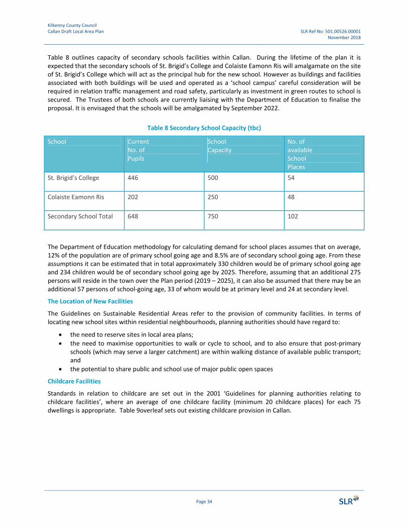
Kilkenny County Council Callan Draft Local Area Plan SLR Ref No: 501.00526.00001
November 2018
Page 34
Table 8 outlines capacity of secondary schools facilities within Callan. During the lifetime of the plan it is expected that the secondary schools of St. Brigid’s College and Colaiste Eamonn Ris will amalgamate on the site of St. Brigid’s College which will act as the principal hub for the new school. However as buildings and facilities associated with both buildings will be used and operated as a ‘school campus’ careful consideration will be required in relation traffic management and road safety, particularly as investment in green routes to school is secured. The Trustees of both schools are currently liaising with the Department of Education to finalise the proposal. It is envisaged that the schools will be amalgamated by September 2022.
Table 8 Secondary School Capacity (tbc)
School
Current No. of Pupils
SchoolCapacity
No. of available School Places
St. Brigid’s College
446
500 54
Colaiste Eamonn Ris
202
250 48
Secondary School Total
648 750 102
The Department of Education methodology for calculating demand for school places assumes that on average, 12% of the population are of primary school going age and 8.5% are of secondary school going age. From these assumptions it can be estimated that in total approximately 330 children would be of primary school going age and 234 children would be of secondary school going age by 2025. Therefore, assuming that an additional 275 persons will reside in the town over the Plan period (2019 – 2025), it can also be assumed that there may be an additional 57 persons of school‐going age, 33 of whom would be at primary level and 24 at secondary level.
The Location of New Facilities
The Guidelines on Sustainable Residential Areas refer to the provision of community facilities. In terms of locating new school sites within residential neighbourhoods, planning authorities should have regard to:
the need to reserve sites in local area plans;
the need to maximise opportunities to walk or cycle to school, and to also ensure that post‐primary schools (which may serve a larger catchment) are within walking distance of available public transport; and
the potential to share public and school use of major public open spaces
Childcare Facilities
Standards in relation to childcare are set out in the 2001 ‘Guidelines for planning authorities relating to childcare facilities’, where an average of one childcare facility (minimum 20 childcare places) for each 75 dwellings is appropriate. Table 9overleaf sets out existing childcare provision in Callan.

Kilkenny County Council Callan Draft Local Area Plan SLR Ref No: 501.00526.00001
November 2018
Table 9 Childcare Facilities
Childcare Facility Location
Droichead Childcare Friary Complex
Little Sunflowers Creche Clonmel Road
Small Wonders Friary Walk
Montessori School Green Street
Ballyhall Steiner Community Kindergarten Callan
6.1.2 Health Facilities
There is a range of facilities in Callan that meet population requirements in relation to community health and care. These include the Callan Primary Care Centre, Strathmore Lodge Nursing Home and Callan Dental. The Camphill community is a disability services provider and charity that operate 20 units of social housing in the Bridge Street / Mill lane area, in collaboration with Kilkenny County Council. The Camphill Community also operates the KCAT Art and Study Centre in Mill Lane and owns a part of the Moat Field. Together with Kilkenny County Council, the community is one of the promoters of the Moat Fields Nature and Heritage Trail through Kilkenny Leader Partnership Funding.
6.1.3 Positive Ageing
The population of Ireland is ageing. According to the Department of Health by the year 2036 the number of older people aged 65 and older living in Ireland is expected to increase by 250%. For County Kilkenny this would mean that the older population of 11,690 in 2011 will increase to 29,225 in 20 years’ time.
Kilkenny County Council has been actively engaged in the Age Friendly County Initiative since 2010. Kilkenny is the second county in Ireland to become an Age Friendly County. The concept of an Age Friendly community is linked to an initiative of the World Health Organisation started in 2007. This initiative seeks to engage older people and their communities in making their communities better, healthier and safer places for older people to live and thrive.
Positive ageing can be facilitated by means of various age friendly initiatives, including universal design and can be supported by the adoption of the appropriate development objectives to facilitate same.
6.1.4 Achieving High Quality Design in New Neighbourhoods
According to ‘Local Area Plans, Guidelines for Local Planning Authorities’ (2013), planning authorities should promote high‐quality urban design in local area plans policies, objectives, and standards. ‘Clearly defined policies create more certainty for potential developers and their design teams, and also provide a basis for developing a shared, collaborative approach to pre‐application consultations with the planning authority.’
Local area plans have a key role in translating overarching development plan urban design policies by
HFO1: It is an objective of Kilkenny County Council to support and implement proposals that will benefit public health, particularly where this meets a defined local need and does not involve displacement of existing services.

Kilkenny County Council Callan Draft Local Area Plan SLR Ref No: 501.00526.00001
November 2018
• defining key elements of local character; • providing detailed guidance regarding layout, density, massing, height, materials, etc., and indicate
minimum/maximum densities; and • including indicative layouts to guide the shape and form of future development, leaving individual
building and open space design to expert designers.
It is this emphasis on local context that must inform and shape design at the local and site specific level in Callan. Proposals should therefore
• Consider and reflect the physical, social and environmental context of the town; • Protect the town’s historic fabric and positively contribute towards its identity and character; • Creating places of distinctive character and legibility; • Improve the public realm and provide for public and private spaces that are clearly distinct and
contribute to continuity and enclosure; • Contribute to improvements in safety by enhancing natural surveillance, providing active street
frontages, and ensuring appropriate enclosure and overlooking of public spaces; • Support increased permeability, strengthening the linkages between places and contributing to a
well‐defined movement network particularly in relation to walking, cycling and access by public transport;
• Ensure that buildings and spaces can adapt to changing environmental, social and economic circumstances, particularly climate change;
• Create variety and choice to support mixed communities, develop the identity of a place and ensure that all new developments are accessible to all; and
• Help to maintain good air and water quality and improve landscaping which can support biodiversity.
6.1.5 Housing and Community Objectives
HC1: It is an objective of this LAP to consolidate residential development within the town boundary, linking delivery of new development to the provision of required services and where appropriate applying the sequential approach to the development of housing land.
HC2: Proposals for residential development should have regard to the Guidelines on Sustainable Residential Development in Urban Areas, and in particular, the objective of limiting the size of individual proposals to 10% ‐ 15% of the existing housing stock. In Callan, the existing housing stock is approximately 1,032 units, which provides a basis for an indicative maximum range of 103 – 155 units, for development proposals.
HC3: Housing on Lands Zoned for Agriculture
Land within the agricultural zone will not be considered for intensive commercial or residential development during the lifetime of this LAP. This is to allow for the strategic expansion of the plan area, and to prevent urban generated development which would interfere with the operation of farming and prejudice the future planning and development of the area. On lands zoned for agriculture within the development boundary of the Callan LAP, housing will be restricted (for their own housing need) to the following categories of persons:
• Persons whose primary employment is in agriculture, horticulture, forestry or bloodstock, or other rural based activity, in the area which they wish to build,
• Sons and daughters of the landowner, all of whom are long standing residents of the “Agricultural” zoned rural area, providing for their first home,
• Persons who are long standing residents in the “Agricultural” zoned area, providing for their first home.

Kilkenny County Council Callan Draft Local Area Plan SLR Ref No: 501.00526.00001
November 2018
6.1.6 Housing and Community – Special Development Objective
HC‐ SDO 1: The development of a residential complex at Westcourt as initiated by the Camphill Community
To facilitate the development of a residential complex (10 units approx.) initiated by the Camphill Community with ancillary small scale socio‐economic uses related to the activities of the residents of the development, and to provide for a pedestrian link from the lands to the town centre, subject to the following:
The development must not interfere with the ecological integrity of the adjacent Kings River which forms part of the River Barrow and River Nore SAC, a Natura 2000 site. Any future development (including pedestrian link) of the lands will be subject to Appropriate Assessment in accordance with Article 6 of the Habitats Directive.
A site‐specific Flood Risk Assessment appropriate to the type and scale of the proposed development and a site specific justification test if required must be submitted at planning application stage in line with the DoEHLG Guidelines “The Planning System and Flood Risk Management”, November 2009. Residential use is excluded from Flood Zone B.
Any developments proposed for the lands at Westcourt must be connected to the foul sewer network for treatment of waste water. Such developments will only proceed subject to the local treatment plant having capacity to adequately treat the additional load. It must be shown by proposals that all storm water can be appropriately collected, stored and treated so as not to affect the quality of water bodies.
The archaeological importance of the site must be safeguarded by protecting archaeological sites and monuments (including their setting), and archaeological objects, including those that are listed in the Record of Monuments and Places, and in the Urban Archaeological Survey of County Kilkenny or newly discovered sub‐surface archaeological remains. Any proposed development in the vicinity or confines of archaeological monuments will require an archaeological assessment and the preparation of an archaeological impact statement for submission as part of any planning application for development within this area.
When innovative layouts and exceptional design for living are achieved, strict adherence to the development management standards for new residential developments as set out in Chapter 12 of the
HC4: The Local Area Plan will ensure that sites are reserved for community facilities as appropriate and to seek to remedy the deficiency in existing developed areas. Where possible, the provision of community facilities will be linked to the increases in the residential population.
HC5: It is an objective of Kilkenny County Council to facilitate the amalgamation of secondary schools St. Brigid’s College and Colaiste Eamonn Ris.
HC6: It is an objective of this Local Area Plan to support the provision of a centrally located library space alongside the emergent creative hub of Callan within the landmark building of the Friary Complex.
HC7: It is an objective of the Plan to promote the sustainable development of vacant residential and regeneration sites in Callan through the application of the Urban Regeneration and Housing Act 2015, Vacant Site Levy, on lands zoned ‘General Business’ and ‘Residential’.
HC8: It is an objective of the Plan to support the actions set out in Kilkenny Age Friendly County Strategy 2017 – 2022 where practicable.
HC9: It is an objective of the Plan to allow for the development of 10 community housing units at Westcourt. See also HC‐SDO 1 below.

Kilkenny County Council Callan Draft Local Area Plan SLR Ref No: 501.00526.00001
November 2018
County Development Plan 2014‐2020 will not be required, provided the proposed designs can be demonstrated to satisfy the social and physical needs of the occupants.
6.1.7 Housing and Community Development Management Objectives
HCDMO 1: To promote Universal Design and Lifetime Housing in accordance with best practice and the policies and principles contained in Building for Everyone: A Universal Approach and Sustainable Residential Development in Urban Areas and its associated document Urban Design Manual: A Best Practice Guide.
HCDMO2: In terms of design and layout, new residential developments of over 3‐4 units should submit design statements in conjunction with applications for permission, explaining the principles and concept behind the design, demonstrating how the proposal relates to the wider context and meets urban design objectives and principles.
HCDMO 3: To facilitate the development of housing for older people in order to improve the quality of living for our ageing population. Any new residential development should focus on complying with the Universal Design approach, so as to facilitate older persons’ living.

Kilkenny County Council Callan Draft Local Area Plan SLR Ref No: 501.00526.00001
November 2018
Page 39
7.0 Cultural, Built and Natural Heritage
7.1.1 Architectural Heritage ‐ Record of Protected Structures
The Record of Protected Structures is a list of the structures that are given statutory protection through the County Development Plan. For the Callan LAP these are listed in Appendix 2.The effect of Protected Structure status is to ensure that any changes or alterations to the character of a structure are carried out in such a way that the existing character is retained and enhanced. Works which would, in the opinion of the Planning Authority, have material effect on the character of the structure will require planning permission. It is important to note that not all works to a Protected Structure will constitute material alterations but that some works which would be exempt to an ordinary structure may require planning permission when carried out to a Protected Structure.
Under Section 57 of the Planning and Development Act 2000, owners and occupiers of protected structures may request a declaration from the Planning Authorities as to the type of works that it considers would or would not materially affect the character of the structure and consequently, which works would or would not require planning permission.
National Inventory of Architectural Heritage
The NIAH forms the basis of the proposed additions to the Record of Protected Structures. The NIAH study of Callan identified ninety eight structures within the confines of the Plan area, with each designation given a national, regional or local importance classification. One designation was classified as national importance, ninety four of regional importance with the remaining three classified as locally important. 77 properties are currently listed under the record of protected structures.
7.1.2 Callan Workhouse
As a result of the Irish Poor Law Act 1838, the Callan Workhouse, located west of Green Street was built in 1840‐1. Designed by the Poor Law Commissioners architect George Wilkinson, and built on a six acre site, the building was based on one of his standard plans to accommodate 600 inmates and declared ‘fit for the reception of paupers’ in December 1841. During the famine further modifications were made to accommodate an additional 190 inmates. The population falling within the Union at the 1831 census had been 42,707 with divisions ranging in size from Grove (population 1,061) to Callan itself (11,148). Linked to the workhouse is the Cherryfield Graveyard (Baunta Commons) which is commonly referred to as a famine/pauper's graveyard to serve those who died in the Callan workhouse. A plaque on a pillar at the graveyard reads: 'In memory of the uncounted victims of famine and poverty buried here, most of whom died in Callan Workhouse 1841‐1922. The Plaque was erected in 1986 by Callan Heritage Society'.
7.1.3 Callan Architectural Conservation Area
The Planning & Development Act 2000 requires a Planning Authority to include in its Development Plan the objective of preserving the character of areas of special architectural, historical, archaeological, artistic, cultural, scientific, social or technical interest. Such areas are designated as Architectural Conservation Areas (ACAs).
The purpose of the designation will be to manage change, affording greater control over the form of development and reducing instances of inappropriate development and demolition. This character is often derived from the collective value of an area’s buildings, their setting, landscape and other locally important features developed gradually over time.

Kilkenny County Council Callan Draft Local Area Plan SLR Ref No: 501.00526.00001
November 2018
Page 40
It is an objective of the County Development Plan ‘to ensure the preservation of the special character of each ACA particularly with regard to building scale, proportions, historical plot sizes, building lines, height, general land use, building materials, historic street furniture and paving.’
The preservation of the character of the Callan Town ACA is essential to safeguarding the identity of the town and maintaining continuity with its development history.
Statement of Character
The collection of buildings and spaces within the ACA represent a unique assemblage of Callan’s built heritage and contribute to its identity, character and attractiveness. The designated area of approximately 10 hectares is located in the historic medieval core of Callan, illustrated in Figure 4, and includes portions of Mill Street, Green Street, Market Lane, West Street and Upper Bridge Street.
The boundary of the ACA includes 21 structures on the Record of Protected Structures, a significant percentage of the total entries within the town boundary. In addition, the NIAH identifies 62 structures of interest within the ACA, which acts as further evidence of the architectural merit within the town. Finally the National Monuments Service has designated a large portion of the town of Callan as a zone of archaeological potential, extender over a wider area totalling 54.34 hectares. Two character areas have been identified within the ACA due to their contrasting characteristics.
The Medieval Core
The characteristics of the medieval core accurately reflect the genesis of the town over the past 800 hundred years with dominant features comprising narrow street dimensions and narrow building plots. The second area consists of the 19th century extension to the town which contrasts with the medieval core and encompasses more generous street dimensions, classically styled civic buildings and a market street.
Callan was established circa 800 years ago with the first town charter being signed in 1207. The core of the town developed during this time encompasses Mill Street, Upper and Lower Bridge Streets, Coyne Street, Mill and Clodine Lane. The streets are narrow and winding and centre primarily on Upper and Lower Bridge Street. The town at this time was also concentrated around three focal points, the Augustinian Friary north of the King’s River, the Motte and St. Mary’s Church, see below, on the south bank, which reinforced the strong north south emphasis of the early town layout.
There are no predetermined grids or angles, but rather an organic layout with layout and building lines responding to natural and historic features and contours. Informal crossing points or fords at the King’s River, connecting the north and south of the town are visible at the junction of Clodine Lane and the King’s River. The interaction between the built environment and river is limited with structures, as is usual in most towns from this era, turning their back on the river.
Callan’s medieval morphology is expressed by the dense arrangement of long narrow plots along its meandering linear street line and narrow laneways. Due to the diminutive street dimensions building heights have been restricted to two to three storeys and limited private open space has been provided to the rear of the buildings that front onto the main thoroughfares.
Although the dereliction of historic properties has become a problem in recent decades the character of the buildings here continue to have significant architectural merit and group value. The majority of the buildings within this area were built in the 19th century, with the associated characteristics of narrow building plots (5 – 7.5 metres), vertical emphasis fenestration, smooth render building finishes and traditional shop fronts evident.
There is a distinct cross pattern to the street layout in the centre of Callan, with the four most significant streets converging on one central point offering a focal point for the urban form. Several ancillary streets / laneways adjoin the four primary thoroughfares offering access to private space; such laneways significantly contribute to the character of the space. A contrast between the narrow built environment of the medieval

Kilkenny County Council Callan Draft Local Area Plan SLR Ref No: 501.00526.00001
November 2018
core is offered by the bridging point over King’s River affording views of King’s River and associated flood plain. The elegantly designed bridge represents an attractive feature of civil engineering heritage, and has historical significance as the central arch was destroyed during the troubles in the early 20th Century.
19th Century Extension
A significant extension to the town was constructed in the 19th Century primarily consisting of Green Street south of the medieval core. The extension offers a contrast to the narrow streets of the central area, with the street dimensions in some places exceeding twenty metres. The resulting streetscape and its generous dimensions have a formal thoroughfare character that has been augmented by the buildings that front onto it. A neat group of landmark public administration buildings offers the street a formal setting, with larger plots and classical style facades, see opposite. The resulting assemblage represents the civic quarter of Callan and the area has been the commercial centre for the town and its environs since its construction.
The designation of the ACA for Callan has taken into account the aforementioned characteristics in defining a spatial boundary within which distinct planning and preservation controls will apply. Please also refer to objective BNH 4 in Section 7.1.4.
7.1.4 Built Heritage Development –Objectives
BNH1: To encourage and apply flexibility in order to secure the appropriate reuse, renovation and rehabilitation of a Protected Structure.
BNH2: To protect and enhance the historic landscape and character of Callan.
BNH3: To make additions to the Record of Protected Structures as appropriate using the provisions of Part IV of the Planning and Development Act 2000 as amended.
BNH 4: Kilkenny County Council considers that the historic core of Callan town comprises an area of special architectural, archaeological, historic interest, presents an attractive townscape and is worthy of protection. It is therefore proposed to continue to designate the area indicated in Figure 4, as an Architectural Conservation Area.
BNH5: It is the policy of the Council to support the protection of archaeological heritage through preservation in situ of, or preservation by record of recorded monuments and any other archaeological features in Callan.
BNH6: It is an objective of Kilkenny County Council to support the National Policy on Town Defences which sets out national policy for the protection, preservation and conservation of the defences of towns and cities.

Kilkenny County Council Callan Draft Local Area Plan SLR Ref No: 501.00526.00001
November 2018
7.1.5 Built Heritage Development – Development Management Objectives
BHDM1: It is an objective of Kilkenny County Council to require an architectural heritage assessment/architectural impact assessment report to be submitted with all applications related to Protected Structures. This should be prepared in accordance with Appendix B of the “Architectural Heritage Protection, Guidelines for Planning Authorities”.
BHDM2: It is an objective of Kilkenny County Council to encourage the retention and restoration of existing buildings and streetscape in a manner which respects its special character and improves that character with appropriate new developments when opportunities arise.
BHDM 3: It is an objective of Kilkenny County Council to require an assessment of the archaeological implications of all development proposals within the zone of archaeological potential.
BHDM 4: To support the sensitive restoration of protected structures and their attendant grounds and operate flexibly as regards facilitating the ongoing use of these buildings subject to good conservation principles.
BHDM 5: To protect and preserve items of both architectural and archaeological heritage from inappropriate development that would adversely affect and/or detract from the interpretation and setting of these sites. These include recorded monuments, structures contained in the Record of Protected Structures, the National Inventory of Architectural Heritage and structures within the Architectural Conservation Area.
BHDM 6: Require consultation with the Council’s Heritage and Conservation Officers to ensure the protection of archaeological heritage of the town and the associated historic landscape. This includes terrestrial archaeology and underwater archaeology for in river works.
BHDM 7: The recognition of embodied energy found within the historic buildings within the town, as an energy saving source.

Kilkenny County Council Callan Draft Local Area Plan SLR Ref No: 501.00526.00001
November 2018
Page 43
Figure 4 Callan Architectural Conservation Area
7.1.6 Archaeological Heritage
Callan is a medieval town and its earliest surviving developments including an Anglo‐Norman motte and the Augustine Abbey are key landmarks, located north of the King’s River. The majority of the town’s physical fabric is evidence of its early development and this is recognised by its designation as a zone of potential archaeological interest.

Kilkenny County Council Callan Draft Local Area Plan SLR Ref No: 501.00526.00001
November 2018
Page 44
Callan is former medieval walled town and in accordance with the National Policy on Walled Towns, these walls are also deemed to be a National Monument. Town defences are therefore considered to be monuments for the purposes of the National Monuments Acts, 1930‐2004.
Historic map sequences for the years 1848, 1903 and 1948 show how little Callan has changed over a period of 100 years. This continuity in the built fabric in Callan has meant that some elements of the town’s early history including landmark buildings as well as narrow lanes and building plots have survived.
Monuments, specifically structures pre‐dating 1700 AD, are protected under the National Monuments Acts 1930 – 2004 and are protected in a number of ways:
‐ national monuments in the ownership or guardianship of the Minister or a local authority; ‐ national monuments which are subject to a preservation order; ‐ historic monuments or archaeological areas recorded in the Register of Historic Monuments; ‐ monuments recorded in the Record of Monuments and Places.
The town has three National Monuments:
‐ St. Mary’s Church ‐ Augustinian Friary ‐ Motte ‐ Callan town walls
The Archaeological Survey of Ireland holds the inventory of archaeological monuments which contains records of all known or possible monuments pre‐dating 1700 AD that have been brought to its attention and also includes a selection of monuments from the post‐1700 AD period. These are referred to as Sites and Monuments Records (SMRs) which formed the basis for the establishment of the statutory Record of Monuments and Places pursuant to Section 12 of the National Monuments (Amendment) Act 1994. The Record of Monuments and Places consists of lists of monuments and places for each county in the State.
The survey also produced reports on all historic towns dating to before 1700 AD with a view to delineating zones of archaeological potential within which archaeological deposits may exist. Callan was subject to this survey and is considered a zone of archaeological potential (See Figure 5).

Kilkenny County Council Callan Draft Local Area Plan SLR Ref No: 501.00526.00001
November 2018
Page 45
Figure 5 Zone of Archaeological Potential (Source: Historic Environment Viewer, Department of Arts, Heritage, Regional, Rural and Gaeltacht Affairs.)
7.2 Natural Heritage& Biodiversity
Callan is located with a lowland area which contains predominantly fertile land with intensive land management. The area is characterised by tillage and pastureland uses with key features such as the gentle topography and low hedging which allows for clear open and extensive landscape views. There are a number of significant natural features in Callan, such as the Kings River, the Abbey Meadow and Motte Field which unite to give the town a unique environmental character which also supporting biodiversity and natural heritage in the town.
7.2.1 The River Barrow and River Nore SAC
Habitats in the county, of international and national importance, are designated under EU and national legislation. SACs, together with Special Protection Areas (SPAs), form a Natura 2000 network of protected areas throughout the EU. There are 8 sites in County Kilkenny designated and protected under the under the Habitats Directive 1992 (92/43/EEC). They have been designated as Special Areas of Conservation (SACs) and Special Protection Areas (SPA’s) due to their conservation value for habitats and species of importance in the European Union. Figure 6 shows part of the River Barrow & River Nore SAC is located within the town boundary.

Kilkenny County Council Callan Draft Local Area Plan SLR Ref No: 501.00526.00001
November 2018
Figure 6 The King’s River ‐ Part of the River Barrow & River Nore SAC (Source npws.ie)
7.2.2 Natural Heritage and Biodiversity ‐ Objectives
NHB1: In seeking to protect and enhance the natural environment, Kilkenny County Council will seek to;
‐ Protect natural heritage sites designated in National and European legislation, specifically the River Barrow and Rivers Nore SAC (See also NH2);
‐ Provide for an appropriate riverside buffer of circa 20m that protects the integrity of the SAC and assists in the management of flood risk;
‐ Protect and conserve non‐designated habitats and species; and ‐ Protect and incorporate existing biodiversity features such as trees, hedgerows
and surface water features into the design and construction of new development and public realm and enhancing the biodiversity value of existing open spaces.
‐ Where development proposals are made along the riparian corridor, ensure that a condition of consent is to establish a vegetated strip along the river in consultation with the National Parks and Wildlife Service.
NHB2: It is an objective of Kilkenny County Council to protect and incorporate existing biodiversity features such as hedgerows and surface water features into the design and construction of new development and public realm. Where the loss of the existing features is unavoidable new biodiversity features should incorporate native species, and species of local provenance to replace the existing hedgerow.
NHB3:It is an objective of Kilkenny County Council to retain the character the Motte Field and Abbey Meadow as high value locally important areas for nature conservation and to enhance biodiversity value within these areas where possible.
NHB4: It is an objective of Kilkenny County Council to ensure best practice is followed as regards tree retention and replacement.
NHB5: It is an objective of Kilkenny County Council to support the implementation of the Callan River Project under the Town and Village Renewal Scheme. The project will consist of the removal of sediment deposits and associated vegetation that has developed within the river channel in recent years.

Kilkenny County Council Callan Draft Local Area Plan SLR Ref No: 501.00526.00001
November 2018
7.2.3 Natural Heritage and Biodiversity ‐ Development Management Standards
NHB ‐ DM1: The King’s River which forms part of the River Barrow and River Nore SAC has considerable potential for to be used as a recreational asset for the town and the Local Area Plan will seek to promote the natural amenity potential of this site subject to:
‐ Protection of this site in accordance with National and European legislation ensuring that any development in or near the SAC will avoid any significant adverse impact on the features for which the site has been designated;
‐ Consultation with the prescribed bodies and relevant government agencies when assessing developments which are likely to impact on designated natural heritage sites or those sites proposed to be designated; and
‐ The requirement for an appropriate assessment in respect of any proposed development likely to have an impact on a designated natural heritage site, or those sites proposed to be designated.
NHB – DM2: New development should ensure, including where necessary through appropriate developer contributions, the efficient and effective use of environmental resources by:
‐ Having regard to sustainable energy considerations set out in Department Guidelines on Quality Housing for Sustainable Communities (2007) and Chapter 10 of the County Development Plan; and
‐ Through the use of sustainable drainage methods.
NHB – DM3: It is an objective of Kilkenny County Council to require all new development to be designed in such a way as to maximise energy efficiency. All new development must consider the potential for decentralised energy systems and renewable or low/zero carbon energy. Planning applications should be accompanied by a ‘low and zero carbon energy statement’ outlining approach to energy efficiency and the use of low and zero carbon technologies.
NHB – DM4: To support and facilitate the development of pedestrian/cycle routes along suitable routes subject to relevant environmental assessments.
NHB – DM5: To support the development of outdoor leisure activities on lands designated as open space, subject to the protection of landscape character and natural heritage.
NHB – DM6: Require the incorporation of natural features where appropriate and to protect existing trees and hedgerows which are of amenity or biodiversity value and/or contribute to landscape character, and to ensure that proper provision is made for their protection and management or replacement, when undertaking, approving or authorising development.
NHB – DM7: To ensure that when approving or authorising development that sufficient information is provided to enable an assessment of impacts on woodlands, trees and hedgerows.
NHB – DM8: All lighting within the Plan area will be required to be directional lighting designed specifically to minimise impact in relation to biodiversity.

Kilkenny County Council Callan Draft Local Area Plan SLR Ref No: 501.00526.00001
November 2018
Figure 7 Low Carbon Energy Options

Kilkenny County Council Callan Draft Local Area Plan SLR Ref No: 501.00526.00001
November 2018
8.0 Recreation, Tourism and the Arts
8.1 Green Infrastructure
The term Green Infrastructure (GI) can be defined as strategically planned and interconnected networks of green space and water capable of delivering ecosystem services and quality of life benefits to people. Green Infrastructure is designed and managed to provide and facilitate the following:
• a high‐quality environment which will provide economic benefits by attracting inward investment and new business;
• high quality open spaces which provide health and social benefits for people through the provision of play areas, safe and attractive areas and routes for meeting, walking and cycling opportunities and space for contact with nature, which is considered essential for good health and wellbeing;
• adaptation to the impacts of climate change and flooding. • local food production ‐ in allotments, gardens and through agriculture space for biodiversity (nature
and wildlife) to flourish a sense of place and local distinctiveness
The emergence of Green Infrastructure planning is a response to the growing recognition of the many benefits which green space provides at a strategic level and of the need to plan for its protection, provision and management in tandem with plans for growth and development. It has a significant role to play in assisting in the protection of Natura 2000 sites and biodiversity and meeting the requirements of the Habitats Directive.
Green infrastructure close to Callan town centre, shown in Figure 8, creates an attractive setting for residents and visitors alike. The protection and enhancing these areas as well as the links between them will play a significant role in enhancing biodiversity and providing opportunities for sustainable travel. It will also support any future tourism strategy for the town, thereby setting the stage for future investment in ancillary tourism and other infrastructure which will support the creation of a more diversified economic base.
In Callan the green infrastructure within the plan boundary includes the designated River Barrow/Nore candidate Special Area of Conservation along the Kings River. The Special Area of Conservation along the Kings River is zoned Open Space/Green Infrastructure with a restriction on its use in order to protect the river and its banks as a green corridor for wildlife and biodiversity. The zoning objective in Appendix 1 confirms this commitment.
The green infrastructure belt therefore runs primarily along the east west axis, along the river. Walking/cycling is encouraged and several objectives for walking/cycling routes have been included in the plan which encourages better north/south connections across the river.
Green infrastructure also includes the undeveloped areas of Callan which are mainly characterised by agricultural grasslands and pastures bordered by hedgerows and backland areas. These areas contribute to the overall levels of biodiversity in the town. Large mature trees are also found on pasture lands adjacent to the river and are integral the setting of the Motte and Augustinian Friary, both National monuments.
Although green infrastructure is generally accessible to the public, the current exception is the Motte Field, which is the subject of a funding application under the Rural Regeneration and Development Fund. This application outlines proposals for improving access and use.
Flood zones have also been identified in the strategic flood risk assessment for the plan. Areas at risk should be kept clear from vulnerable developments so as to safeguard future developments from the potential impacts of flooding.
GI1: It is an objective of Kilkenny County Council to develop a Green Infrastructure Strategy for the town, linked to its urban regeneration.

Kilkenny County Council Callan Draft Local Area Plan SLR Ref No: 501.00526.00001
November 2018
Page 50
Figure 8 Green Infrastructure
Open Space
The quantity, quality, variety and accessibility of open space are all factors that influence the use of public space. Guidelines on Sustainable Residential Development in Urban Areas emphasise the importance of qualitative standards regarding open space and sets out the key qualitative standards that open spaces should expect to achieve.
Callan currently has approximately 15.98ha of land zoned as open space. Much of this is centred on the Motte, Friary Meadow, the Fairgreen and John Lockes GAA Club which are at central and accessible locations within the town, though the GAA Club has limited access by its surrounding high walls. Both the Motte and the Friary Meadow are located on the banks of the King’s River and are of considerable importance to the natural and historical environment.
One of the open spaces, the Abbey Meadow, includes an Augustinian Priory, centrally located adjacent to King’s River. Around the Augustinian Priory there is a designated walk Callan Abbey Meadow Walk which is a loop walk crossing King’s River and passing the KCAT Arts Centre and Abbey Meadow. It’s a wheelchair accessible walk with access to main building, as well as free public car park and seating along the trail including the riverbank showcasing some of Callan’s main heritage attractions.
OS1: Class I – Strategic Open Space
Both the Motte and the Friary Meadow constitute Strategic Open space in the town due to their structural role and to the variety of important functions they play. These sites vary in terms of levels of accessibility and activity, with surrounding land use and active ground floor use contributing toward the greater use of the Friary Meadow.
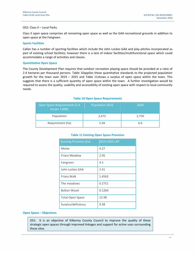
Kilkenny County Council Callan Draft Local Area Plan SLR Ref No: 501.00526.00001
November 2018
OS2: Class II – Local Parks.
Class II open space comprises all remaining open space as well as the GAA recreational grounds in addition to open space at the Fairgreen.
Sports Facilities
Callan has a number of sporting facilities which include the John Lockes GAA and play pitches incorporated as part of existing school facilities; however there is a lack of indoor facilities/multifunctional space which could accommodate a range of activities and classes.
Quantitative Open Space
The County Development Plan requires that outdoor recreation playing space should be provided at a ratio of 2.4 hectares per thousand persons. Table 10applies these quantitative standards to the projected population growth for the town over 2019 – 2025 and Table 11shows a surplus of open space within the town. This suggests that there is a sufficient quantity of open space within the town. A further investigation would be required to assess the quality, usability and accessibility of existing open space with respect to local community needs.
Table 10 Open Space Requirements
Open Space Requirements (2.4 ha per 1,000)
Population 2016 2020
Population 2,475 2,750
Requirement (ha) 5.94 6.6
Table 11 Existing Open Space Provision
Existing Provision (ha) 2019‐2025 LAP
Motte 4.27
Friary Meadow 2.95
Fairgreen 4.5
John Lockes GAA 2.41
Friary Walk 1.4563
The meadows 0.2751
Bolton Wood 0.1264
Total Open Space 15.98
Surplus/deficiency 9.38
Open Space – Objectives
OS1: It is an objective of Kilkenny County Council to improve the quality of these strategic open spaces through improved linkages and support for active uses surrounding these sites.

Kilkenny County Council Callan Draft Local Area Plan SLR Ref No: 501.00526.00001
November 2018
Open Space– Development Management Objectives
Open Space ‐ Special Development Objectives
Play Space – Development Management Objectives
OSDM1: According to quantitative standards, sufficient quantity of open space is currently in place. A qualitative assessment is now required to understand the scope for improvements with respect to each green space both in terms of its usability together with its value for biodiversity.
OSDM2: In terms of future enhancement, together with the improvements identified as part of the qualitative open space assessment, it is an objective of Kilkenny county Council to;
‐ Protect and enhance the strategic role of areas likely to flood, through the identification of a flood risk buffer and linear park, where appropriate, alongside the Kings River and elsewhere where surface water features are present;
‐ Protect and enhance these areas in terms of their biodiversity value particularly in areas close to River Barrow and River Nore SAC;
‐ Improve access to and management of public spaces and pockets parks in the town centre;
‐ Achieve design principles set out in the County Development Plan and specifically designing for active frontages and natural surveillance; and
‐ Improve management of these space though natural means, avoiding the use of the herbicide glyphosate.
SDO‐ OS1: To implement the Fair Green Regeneration Scheme in line with a recently approved part 8 application.
SDO‐ OS2: To develop the Motte Field as part of the Green infrastructure Strategy for the town with all stakeholders.
SDO‐ OS3: To allow for a potential public space /pocket park at St. Mary’s Church and graveyard through development of a joint proposal by key stakeholders that takes into account built heritage constraints and management requirements.
PSDM1: New residential development is required to be consistent with standards set out in the County Development Plan where playable space is to be provided as an integral part of each new development. This playable space can form part of the overall open space provision of a development but must be dedicated to play and must be accessible in accordance with the standards in the County Development Plan.

Kilkenny County Council Callan Draft Local Area Plan SLR Ref No: 501.00526.00001
November 2018
Sports Facility ‐ Objective
SF1: It is an objective of Kilkenny County Council to support/advance the provision of a district level indoor sports facility in Callan.
SF2:It is an objective of Kilkenny County Council to support the development of facilities at John Lockes GAA.
SF3: It is an objective of Kilkenny County Council to retain sports and recreational facilities in the town for the benefit of the town inhabitants and the wider catchment area..

Kilkenny County Council Callan Draft Local Area Plan SLR Ref No: 501.00526.00001
November 2018
8.2 Tourism, Arts and Culture
8.2.1 Tourism
Callan is well‐distinguished as a mediaeval town mixed with 19th century architecture and layout offering the visitor a contrasting streetscape of narrow lanes and open views. The old‐fashioned storefronts along the main streets and contemporary murals all contribute to the unique experience.
Callan has significant potential for heritage‐led tourism and related services have become a viable option for the town. Callan is located within the area designated by Failte Ireland as Ireland’s ‘Ancient East’. Exploring the strategic fit with this brand architecture provides the potential for growing visitor numbers for the town and provides new opportunities for Callan to cluster brand its products and link it to other offerings in the region including Kilkenny City.
Kilkenny County Council Tourism Strategy and Work Programme 2017‐2022 actions support the improvement of visitor experiences. Specifically the following actions are of relevance to Callan:
• Action 3.3: Undertake an Asset mapping exercise across the county to develop: area based specific tourism strategies.
• Action 3.6: Design a county marketing and communications strategy….aimed at increasing visitor numbers, sustaining the quality of the visitor experience and prolonging the visitor's stay in the county.
Features of interest within Callan that have most tourism potential include:
• Mary’s Church; • Augustinian Friary; • the Norman Motte; • Tony O’Malley birth place; • Workhouse and historic famine graveyard in Cherryfield; • Edmund Rice birth place; and • Skerry’s Castle on West Street
Notably, there is currently no hotel or B&B located in the town centre.
Tourism Objectives
TO1: It is an objective of Kilkenny County Council to carry out an asset mapping exercise for Callan.
TO2: It is an objective of Kilkenny County Council in conjunction with the Town Team to prepare a marketing and communications strategy aimed at increasing visitor numbers.
TO3: To facilitate tourism activities such as eco‐tourism, niche retailing, food markets, local and other craft type activities so as to diversify the tourism product in Callan, subject to relevant environmental assessments.
TO4: To support the development of standardised signage and interpretation for tourism facilities and tourist attractions throughout Callan.
TO5: To support the development of linkages between historical sites within and around Callan.

Kilkenny County Council Callan Draft Local Area Plan SLR Ref No: 501.00526.00001
November 2018
Tourism – Development Management Objectives
8.2.2 Arts, Culture & the Creative Economy
Arts and culture activities enable people to develop a sense of ownership of their area and to achieve a sense of place. The provision of the necessary community infrastructure is vital if arts and culture related activities are to expand and continue to make a meaningful impact in the plan area. There is potential for the area to generate tourism through arts/music festivals, art exhibitions and installations, etc.
The strong arts community in Callan includes several theatre groups and facilitates the organization of the annual festival Abhainn Rí Festival of Participation and Inclusion since 2010, holding a series of events for a week each year aiming to bring people together. The vibrancy of the arts activities in Callan also holds additional tourism potential.
Kilkenny County Council supports cultural participation and practice through partnerships and collaborations, through significant direct and indirect support and through the provision of cultural infrastructure across the City and County. Kilkenny’s Culture and Creativity Strategy 2018–2022 is an Integrated Strategic Plan for the delivery of the Arts, Heritage and Library Services of Kilkenny County Council. Its five strategic priorities include
1. Enable best practice delivery of culture 2. Increase and diversify participation 3. Support culture in rural and urban areas 4. Engage children and young people in culture 5. Communicate the value of culture
Kilkenny County Council has an ambitious capital programme for 2018 – 2022, including investment in key cultural infrastructure in the county. This includes, but is not limited to the Callan Cultural Hub: Proposed Capital Project also referred to as the Friary Conservation Plan which is the subject of a funding application under the Rural Regeneration and Development Fund. Funding is sought to support the development of the Friary Complex as a cultural and creative hub with a modern library service at its centre. The application refers to the ‘Our Public Libraries 2022’ which seeks to reinforce the local library as a trusted place at the centre of the community’. The application which is currently under consideration seeks funding to undertake a specialist condition and conservation survey of the full Friary Complex and to then complete a masterplan for the strategic development and use of the property as a flexible and integrated library, community and creative youth facility.
In Callan, there are also a number of very active arts and community groups which provide a strong basis for a community and arts led regeneration approach to improving the town centre, particularly around Bridge Street. Together with Callan’s unique townscape and history these groups form part of an important cultural asset base in the town. They include an existing ‘civic cluster’ at Callan Workhouse.
8.2.3 Arts, Culture & the Creative Economy Objectives
TDMO1: All new tourism development should be designed to ensure that assets and features are universally accessible with a view to promoting inclusive tourism.
ACCE1: It is an objective of Kilkenny County Council to support festivals and cultural events across the County.
ACCE2: It is an objective of Kilkenny County Council to enhance the role of venues within district towns to facilitate satellite events associated with some of the County’s signature festivals.

Kilkenny County Council Callan Draft Local Area Plan SLR Ref No: 501.00526.00001
November 2018
9.0 Infrastructure and Environment
9.1 Water Services
Irish Water (IW) aims to deliver improvements to water services throughout Ireland where they are needed most. The primary function of Irish Water is to provide clean drinking water to customers and to treat and return wastewater safely to the environment.
Irish Water’s Investment Plan is a capital investment portfolio over a five year period. A draft Irish Water Investment Plan 2020 to 2024 has recently been prepared to facilitate a stakeholder engagement process. This plan states that ‘Irish Water will optimise investment decisions by prioritising the best possible service improvements, while maximising value‐for‐money.’
Waste Water Treatment
The existing treatment plant in Callan has a capacity for population of 4000 and all properties within the town are connected. However it’s a combined system with mixed storm and foul water which can be problematic when flood events occur. The town also has a proliferation of pumping stations. A strategic assessment of the towns existing network of pumping stations is required and the requirement for additional stations should be limited where possible.
Within Irish Water’s Draft Investment Plan a provisional and draft list of projects and programmes is provided. The projects and programmes listed are expected to be commenced, progressed or completed during the 2020‐2024 period. Callan WWTP is included under this list and Table 15 provides an extract from the supplementary capacity register. However, in relation to headroom (PE), the register states that the available capacity is not confirmed until environmental and asset assessments are completed. In terms of additional comments in relation to the Callan WWTP, it also states that more stringent Emission Limit Values are required from 2020.
Table 12 Existing Capacity of the Callan WWTP
Capacity ‐ today (PE) Load ‐ in 2017 (PE) Capability – now or by 2021 Headroom (PE)
4,000 2,227 UWW 1,773
Water Supply
The supply of water for Callan is met from a local spring source supplemented by a borehole supply. The spring capacity is approximately 30‐35 cu/hr which is then topped up from the borehole supply. Demand is currently running at 45‐48 cu/hr and whilst this capacity is being met at the moment, the capacity of the borehole is unknown. This renders the overall water supply infrastructure functional but tenuous in respect of future development.
There is sufficient pressure in the network at present. The key issue is the maintenance of sufficient head at the water tower and pipe restrictions within the network.
ACCE3: It is an objective of Kilkenny County Council to support the Friary Conservation Plan and the development of the Friary Complex as a cultural and creative hub with a modern library service at its centre.
ACCE4: It is an objective of Kilkenny County Council to investigate the feasibility of providing additional cultural facilities in Callan.

Kilkenny County Council Callan Draft Local Area Plan SLR Ref No: 501.00526.00001
November 2018
Infrastructure – Development Objectives
IN1: Kilkenny County Council will support the completion of an Irish Water survey over the next 2‐3 years to assess the constraints on the waste water network in Callan. This will include an assessment of existing overflows, (one of which is located at the Clodeen pump station).
IN2: To ensure that any significant additional development in Callan is only allowed once the necessary water and wastewater capacity is in place.
IN3: It is an objective of Kilkenny County Council to align future development with capacity at the Callan Waste Water Treatment Plant to ensure that improvements are sufficient to meet standards required to avoid significant adverse effects on the River Nore and River Barrow SAC.
IN4: In conjunction with Irish Water, the Council will endeavour to maintain an adequate water supply sufficient for the development needs of the Plan.
IN5: To support optimal utilisation of existing pumping stations and limit the number of additional / future pumping stations to a minimum.

Kilkenny County Council Callan Draft Local Area Plan SLR Ref No: 501.00526.00001
November 2018
9.2 Flooding
Flooding is a natural phenomenon and where there is no risk to human life and property it is beneficial as it provides fertile sediments for farmland, maintains valuable wildlife habitats and reduces flood risk elsewhere in the catchment. The floodplain, the flat or nearly flat land adjacent to a stream or river that experiences occasional or periodic flooding, plays a key role in this process and acts as a temporary store for flood waters and facilitates their conveyance and flood levels downstream. A number of human activities tend to restrict the capacity of rivers to accommodate large storm flows. These include:
Greenfield Development: Paving over previously permeable areas for roads, housing, car parks, etc. can significantly restrict the potential infiltration rate of the area covered. This activity might have a minor or negligible impact in large river basins (due to flood peak timing and proportion of area developed), but could substantially increase runoff in small river basins (i.e. by more than 100%).
Changes in Land Use or Land Use Practices: Changes in the vegetation cover, the way in which land is used, or measures which impact negatively on natural flood retention areas (wetlands), can have impacts on both interception and infiltration.
Flooding – Development Management Objectives
FDM1: To adopt a comprehensive risk‐based planning approach to flood management to prevent or minimise future flood risk. In accordance with the Planning System and Flood Risk Management – Guidelines for Planning Authorities, the avoidance of development in areas where flood risk has been identified shall be the primary response.
FDM2: In areas at risk from flooding, (particularly at riverside locations) a precautionary approach will apply and the methodology set out in the Planning Guidelines ‘The Planning System and Flood Risk Management’ will be applied to development proposals.
FDM3: Where flood risk may be an issue for any proposed development, including pluvial flood risk, a flood risk assessment shall be carried out that is appropriate to the scale and nature of the development and the risks arising. This shall be undertaken in accordance with the Flood Risk Assessment Guidelines. Proposals for mitigation and management of flood risk will only be considered where avoidance is not possible and where development can be clearly justified with the Guidelines’ Justification Test.
FDM4: The Council will support the introduction of attenuation measures that would reduce levels of surface water discharge into the main water course, thereby reducing the risk of flooding and supporting improvements to the quality of water. To do this, the Council will encourage surface water management for all green‐field developments, whereby surface water run‐off will be limited to pre‐development levels.

Kilkenny County Council Callan Draft Local Area Plan SLR Ref No: 501.00526.00001
November 2018
In the case of brown‐field development, while existing surface water drainage measures will be taken into account, some attenuation measures for surface water may be required at the discretion of the planning authority in the interests of balanced and sustainable development.
In line with the above the Council will consider all drainage proposals consistent with SuDS (Sustainable Urban Drainage Systems). In the design of surface water systems, regard shall be had to the Greater Dublin Regional Code of Practice for Drainage Works and associated GDSDS technical documents.
9.3 Energy
The National Planning Framework (National Policy Objective 54) require that we reduce our carbon footprint by integrating climate action into the planning system in support of national targets for climate policy mitigation and adaptation objectives, as well as targets for greenhouse gas emissions reductions. This LAP must identify the opportunities to reduce the demand for energy and use a better mix of low carbon energy sources. Measures to enhance sustainable travel will also reduce the need for travel by car. Sustainable transport objectives are identified in Section 10.7. The following objectives therefore relate to achieving a reduction in the demand for energy and use a better mix of low carbon energy sources.
Energy Objectives
EO1: It is an objective of Kilkenny County Council to require all new development to designed in such a way as to maximise energy efficiency.
EO2: It is an objective of Kilkenny County Council to require all development to consider the potential for decentralised energy systems and for renewable energy to be integrated into the design of new development. Proposals should be accompanied by a ‘low and zero carbon energy statement’ outlining proposals for energy efficiency as well as the use low and zero carbon technologies.
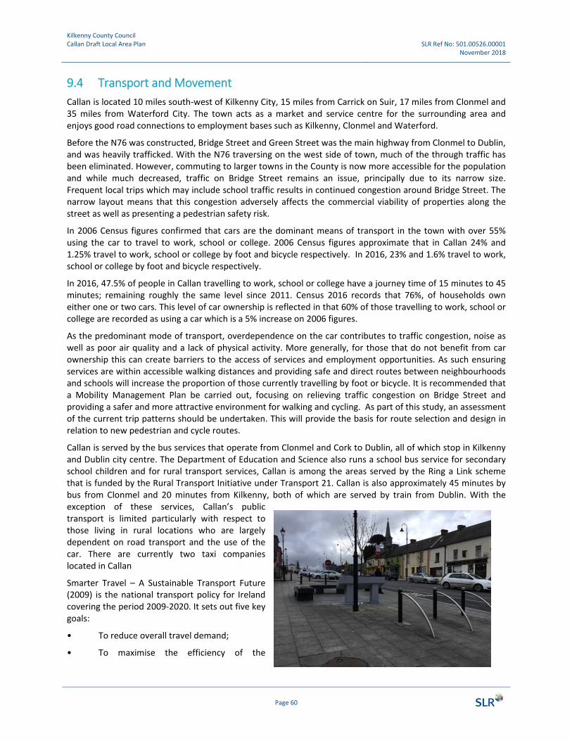
Kilkenny County Council Callan Draft Local Area Plan SLR Ref No: 501.00526.00001
November 2018
Page 60
9.4 Transport and Movement
Callan is located 10 miles south‐west of Kilkenny City, 15 miles from Carrick on Suir, 17 miles from Clonmel and 35 miles from Waterford City. The town acts as a market and service centre for the surrounding area and enjoys good road connections to employment bases such as Kilkenny, Clonmel and Waterford.
Before the N76 was constructed, Bridge Street and Green Street was the main highway from Clonmel to Dublin, and was heavily trafficked. With the N76 traversing on the west side of town, much of the through traffic has been eliminated. However, commuting to larger towns in the County is now more accessible for the population and while much decreased, traffic on Bridge Street remains an issue, principally due to its narrow size. Frequent local trips which may include school traffic results in continued congestion around Bridge Street. The narrow layout means that this congestion adversely affects the commercial viability of properties along the street as well as presenting a pedestrian safety risk.
In 2006 Census figures confirmed that cars are the dominant means of transport in the town with over 55% using the car to travel to work, school or college. 2006 Census figures approximate that in Callan 24% and 1.25% travel to work, school or college by foot and bicycle respectively. In 2016, 23% and 1.6% travel to work, school or college by foot and bicycle respectively.
In 2016, 47.5% of people in Callan travelling to work, school or college have a journey time of 15 minutes to 45 minutes; remaining roughly the same level since 2011. Census 2016 records that 76%, of households own either one or two cars. This level of car ownership is reflected in that 60% of those travelling to work, school or college are recorded as using a car which is a 5% increase on 2006 figures.
As the predominant mode of transport, overdependence on the car contributes to traffic congestion, noise as well as poor air quality and a lack of physical activity. More generally, for those that do not benefit from car ownership this can create barriers to the access of services and employment opportunities. As such ensuring services are within accessible walking distances and providing safe and direct routes between neighbourhoods and schools will increase the proportion of those currently travelling by foot or bicycle. It is recommended that a Mobility Management Plan be carried out, focusing on relieving traffic congestion on Bridge Street and providing a safer and more attractive environment for walking and cycling. As part of this study, an assessment of the current trip patterns should be undertaken. This will provide the basis for route selection and design in relation to new pedestrian and cycle routes.
Callan is served by the bus services that operate from Clonmel and Cork to Dublin, all of which stop in Kilkenny and Dublin city centre. The Department of Education and Science also runs a school bus service for secondary school children and for rural transport services, Callan is among the areas served by the Ring a Link scheme that is funded by the Rural Transport Initiative under Transport 21. Callan is also approximately 45 minutes by bus from Clonmel and 20 minutes from Kilkenny, both of which are served by train from Dublin. With the exception of these services, Callan’s public transport is limited particularly with respect to those living in rural locations who are largely dependent on road transport and the use of the car. There are currently two taxi companies located in Callan
Smarter Travel – A Sustainable Transport Future (2009) is the national transport policy for Ireland covering the period 2009‐2020. It sets out five key goals:
• To reduce overall travel demand;
• To maximise the efficiency of the

Kilkenny County Council Callan Draft Local Area Plan SLR Ref No: 501.00526.00001
November 2018
transport network;
• To reduce reliance on fossil fuels;
• To reduce transport emissions; and
• To improve accessibility to transport.
Small towns, because of their size, provide considerable scope for improving the use of sustainable modes of transport. In addition to size, it appears that due that the ratio of jobs to workers which is at 0.923 and almost on par, Callan might provide additional scope for promoting modal shift.
The plan outlines details of pedestrian/cycle links which will increase connectivity in the area, in particular the provision of a pedestrian/cycle path connection over the Kings River between the Motte Field and West Street and along Clodine lane connecting the Mill Street to the Abbey Meadow and schools beyond. This latter route should form part of a wider route linking residential areas with schools and should be designed in accordance with safe routes to school design criteria.
There is ample free street parking in Callan, primarily located around on Green Street and next to larger places of business such as SuperValue, Aldi. There is also a free public car park adjacent to KCAT and Callan Priory. Green Street has seen major improvements to the pedestrian environment with the rationalising of car parking, new and wider, wheelchair accessible footpaths with benches and interpretative signage to what is the most commercially vibrant part of town. This presents a contrast to northern parts of town, particularly Bridge street which is a poor pedestrian environment with low levels of commercial vibrancy. There is no designated cycle infrastructure in or around Callan town, however there is some bike parking in the town centre, some found on Green Street. Despite these improvements, there is now a requirement for a car parking strategy for the town centre that incorporates a more managed approach to parking on Green Street and provide more opportunities for off street parking.
Transport Objectives
Based on a general assessment of connectivity and permeability with respect to new and existing zoning designations, it is the objective of the Local Area Plan to support and facilitate sustainable transport within the town through measures to improve connectivity, reduce traffic congestion, reconfigure car parking and providing for sustainable forms of transport such as walking and cycling. The objective of reversing unsustainable travel patterns through the promotion of walking and cycling sits at the heart of the LAP strategy. Furthermore this objective comes with wider benefits such as improvements to the environment and public health.
TSDO1: It is an objective of Kilkenny County Council to carry out a Bridge Street / Mill Street Regeneration and Mobility Management Plan.
TSDO2: Safety improvements on the National Road at the junction of the N76 and R699 are required to address general safety issues and sight lines in particular.
TSDO3: Improve Pedestrian crossing facilities on the N76 at the R695 and L1020 junctions.
TSDO4: to implement the Fair Green Regeneration Scheme in line with a recently approved part 8 application.

Kilkenny County Council Callan Draft Local Area Plan SLR Ref No: 501.00526.00001
November 2018
TSDO5: It is an objective of Kilkenny County Council to carry out a car parking strategy for the town centre as part of the mobility management plan that identifies an improved and managed approach to parking on Green Street and provide more opportunities for off street parking elsewhere in the town.
TSDO6: It is an objective of Kilkenny County Council to support the provision of pedestrian / cycle access, through provision of bridge infrastructure in order to enhance connectivity between the town and the Motte Field.
TSDO7: It is an objective of Kilkenny County Council to provide a walking and cycling route from Clodeen Lane to the car park at Mill lane / friary meadow through provision of bridge infrastructure.
TSDO8: it is a long term objective to make a road connection between the Windgap road and Mill Street .
TSDO9: it is a long term objective to improve road connections between north and south Callan over the King’s River.

Kilkenny County Council Callan Draft Local Area Plan SLR Ref No: 501.00526.00001
November 2018
10.0 Implementation
10.1 Introduction The responsibility for the implementation of policies and objectives contained within this LAP will be dependent on a number of possible sources, including EU programmes and grants, the National Government, the County Council and the private sector. Of particular relevance, is the recently announced €1bn Rural Regeneration and Development Fund which will apply to all settlements and rural areas with fewer than 10,000 people, which will operate under the Department of Rural and Community Development.
The Council will also require developers to incorporate the objectives and development management standards of this plan into their development proposals. Other objectives, particularly key infrastructural elements, will require government funding and support.
Where appropriate, the Council will seek financing from specified sources, both the public and private sector, as well as from EU programmes and grants. The implementation of a plan may be constrained by a number of elements, namely, the economic climate, political support, allocated local authority funding, and the availability of funding from other sources. Therefore, no funding of projects is guaranteed in advance nor is the implementation of all objectives contained within the plan. The Council will endeavour to implement the LAP to the fullest extent possible.
It is intended that various agencies, including voluntary groups, professional institutions, public and private bodies, and other organisations will be encouraged to participate whenever possible, in the implementation of the policies and objectives of this plan.
10.2 Development Management
This LAP outlines specific policies and objectives of the Council with regard to developing Callan. The overarching policies and objectives of the County Development Plan (CDP) also apply. As regards the general Development Management Standards, the standards applicable to the County Development Plan will also apply to this Local Area Plan unless otherwise stated.
Where conflict exists between the LAP and the County Development Plan, the County Development Plan will take precedence.
Development Management Objective
10.3 Masterplanning Approach
A Masterplan sets out proposals for buildings, spaces, movement and land use in three dimensions and is an important element of the development process as it can deliver high quality outcomes. It brings a number of key benefits which include:
Helping to shape the physical form of development that responds to local economic and social dynamics;
Helping to identify the potential of an area or site for development;
Unlocking previously under developed land;
Helping to build consensus about the future of an area; and
Defining proposals that will deliver high quality building, sustainable buildings and public spaces.
DMO1: It is an objective of Kilkenny County Council to implement land use zoning objectives for the plan area asset out in Appendix 1.
Kilkenny County Council Callan Draft Local Area Plan SLR Ref No: 501.00526.00001
November 2018
Page 64
Masterplans are most useful where the scale of change is significant and the area subject to change consists of more than a few buildings. Each masterplan should have regard to the zoning objectives for the site in question and the following urban design principals.
10.4 Urban Design Principals The urban structure of Callan is defined by existing building layout and use as well as routes and spaces that provide connections between various activities such as the town centre, residential areas, schools and open spaces. New development should be integrated into this existing framework but most also identify opportunities to improve the way in which the town function particularly where this delivers wider benefits relating to public health, the use of existing services and infrastructure as well as improvement to design of the urban environment. Ultimately, all development proposals, and particularly proposals that are significant in terms of scale should achieve high quality, functional and well‐designed environments.
A set of principles has been developed to inform the design of ALL new development in the town:
• Consider and reflect the physical, social and environmental context of the site and the surrounding area;
• Protect the town’s historic fabric and positively contribute towards its identity and character; • Improve the public realm and provide for public and private spaces that are clearly distinct and
contribute to continuity and enclosure • Contribute to improvements in public safety by enhancing natural surveillance, providing active street
frontages and ensuring appropriate enclosure and overlooking of public spaces; • Support increased permeability, strengthening the linkages between places, particularly in relation to
walking, cycling and access by public transport; • Ensure that buildings and spaces can adapt to changing environmental, social and economic
circumstances, particularly climate change; • Promote low and zero carbon technologies to meet the heating and electricity demand; • Ensure a choice and mix of uses with a variety of types, sizes, designs to support mixed communities
and, in housing, a mix of tenures for all sectors of the community; • Support improvements to air and water quality through good quality landscaping which can support
biodiversity.
The established principles of good urban design should be applied to all new development in the Plan area and shall include those set out in the following policy documents and design manuals:
• Sustainable Residential Development in Urban Areas – Guidelines for Planning Authorities (2009) • Urban Design Manual; A Best Practice Guide (2009) • Design Manual for Urban Roads and Streets (DMURS) (2013)
10.5 Masterplan Areas
A masterplanning approach should be undertaken by the project proponent and the output submitted/ presented to the local Planning Authority as part of a planning application as a means of demonstrating that key urban design and good place making principles have been fully considered in the proposed design. The Masterplan should show:
How the streets, squares and open spaces relate to the development area and how these areas could be better connected
Suggested relationships between buildings and public spaces; and
An understanding of how well new neighbourhoods are integrated with the surrounding urban context and natural environment.
Kilkenny County Council Callan Draft Local Area Plan SLR Ref No: 501.00526.00001
November 2018
Page 65
It is the policy of this Local Area Plan to request masterplans for the following areas which have been deemed suitable for change and development
1. West Street Mixed Use Development Area 2. Mill Street Potential Redevelopment Area 3. Rear of Bolton Wood 4. Bolton Wood Employment Zone 5. West Street / Chapel Lane Infill Area
Map 01 identifies these areas where a masterplan is required and in relation to those areas within the town centre, Map 02 sets out some of the key considerations that should be factored into the design of development within the town centre and in close proximity to Bridge Street. Where linkages are identified in Map 01 and 02, the location is indicative and final proposals will be identified at the more detailed design stage.
The areas close to the town centre present significant opportunities to improve the overall function of the town centre and bridge street in terms of pedestrian linkages and encouraging footfall in particular. However, due to their location, there are a number of constraints that must be considered as part of the masterplanning process, these include but are not limited to flood risk, protected structures, national monuments and ecological constraints close to the Kings River which is part of the River Barrow and River Nore SAC.
10.6 Development objectives for Masterplan Areas
Development objectives for each masterplan areas are set out below.
10.6.1 West Street Mixed Use Development Area
As set out above a masterplan approach is required for this Mixed Use Development Area. This masterplan, should be completed by a multidisciplinary team that includes relevant design professionals e.g. architect as well as technical expertise in relation to planning, transport planning, engineering and environmental science. The following development objectives should be addressed and inform the detailed design of proposals:
‐ Identify appropriate pedestrian and cycle route and prepare proposals in accordance with Design Manual for Urban Roads and Streets (DMURS) (2013);
‐ Conservation proposals for protected structures within the masterplan area should be identified on the basis of condition survey;
‐ Appropriate and realistic proposals should be identified for the reuse historic properties whilst maintaining their character, particularly in respect of their collective contribution to the Bridge Street Townscape/Streetscape;
‐ Carry out a site specific flood risk assessment in accordance with the recommendations of the SFRA. ‐ Carry out stage 1 screening in accordance with the requirements of the Habitats Directive and
conservation objectives of River Barrow and River Nore SAC; ‐ Identify detailed proposals with regard to the provision of pedestrian and cycle bridge infrastructure.
10.6.2 Mill Street Potential Redevelopment Area
As set out above a masterplan approach is required for this Development Area, which includes a significant area of underutilised land to the rear of Mill street and Clodine Lane. The focus of this masterplan should be the delivery of a pedestrian and cycle route that connects schools to the North of Callan with residential areas located south of the river. The masterplan should be completed by a multidisciplinary team that includes relevant design professionals but led by specialists in design of space for sustainable travel. Expertise in relation to planning, engineering and environmental sciences particular in relation to ecology and flood risk will also be required. The following development objectives should be addressed and inform the detailed design of proposals:

Kilkenny County Council Callan Draft Local Area Plan SLR Ref No: 501.00526.00001
November 2018
Page 66
‐ Identify appropriate pedestrian and cycle route and prepare proposals in accordance with Design Manual for Urban Roads and Streets (DMURS) (2013);
‐ Conservation proposals for Protected structures within the masterplan area should be identified on the basis of condition survey completed and approved by the Kilkenny County Council Heritage Officer;
‐ Carry out a site specific flood risk assessment; ‐ Carry out stage 1 screening in accordance with the requirement of the HDA River Barrow and River
Nore SAC; and ‐ Identify detailed proposals with regard to the provision of pedestrian and cycle bridge infrastructure.
10.6.3 Rear of Bolton Wood
As set out above, a masterplan approach is required for the area to the rear of Bolton Wood. This masterplan will focus on achieving high quality design of circa 2 ha of land zoned for low density residential development. Masterplan proposals must to be submitted and agreed with Kilkenny County Council in advance of any applications. The proposed design should:
‐ resolve the design issues presented by unfinished development already in place at this location; ‐ identify linkages with development in the surrounding area; and ‐ Identify measures to achieve zero or low carbon development, through the integration of renewable
energy proposals and energy efficient design.
10.6.4 Bolton Wood Employment Zone
A masterplan approach is required for the area to the rear of Bolton Wood. This masterplan will focus on achieving high quality industrial development, layout of buildings and high standards of infrastructure. Masterplan proposals must to be submitted and agreed with Kilkenny County Council in advance of any applications. The proposed design should:
‐ identify linkages with development in the surrounding area with particular regard to the need to deliver wider connections in the town; and
‐ Identify measures to achieve zero or low carbon development, through the integration of renewable energy proposals and energy efficient design.
10.6.5 West Street / Chapel Lane Infill Area
A masterplan approach is required for the area to the rear of Bolton Wood. This masterplan will focus on achieving high quality infill residential development. Masterplan proposals must to be submitted and agreed with Kilkenny County Council in advance of any applications. The proposed design should:
‐ identify linkages with development in the surrounding area with particular regard to the need to deliver improved pedestrian connections with Chapel lane and Clonmel Road;
‐ Identify measures to achieve zero or low carbon development, through the integration of renewable energy proposals and energy efficient design; and
‐ Maintain high standards of residential amenity of surrounding areas.
10.7 Infrastructure Delivery Schedule The Guidelines on Local Area Plans advise that LAPs should include an Implementation and Infrastructure Delivery Schedule. Developing areas depend on the integrated delivery of essential social and physical infrastructure. This LAP has set out the strategic elements of infrastructure (water services, access etc.) but the development of land in private ownership can also contribute to the overall provision of physical and social infrastructure.

Kilkenny County Council Callan Draft Local Area Plan SLR Ref No: 501.00526.00001
November 2018
Page 67
A number of areas have been identified for residential, or a mix of residential and other uses, under this Plan. These areas, referred to as masterplan areas, have the potential to contribute an element of social or physical infrastructure which could benefit a larger area and objectives have been attached which must be completed in tandem with development of the site. These objectives / infrastructure requirements have been identified in Table 13 below.
Table 13 Infrastructure Delivery Schedule
Masterplan Area Infrastructure Requirements Key Delivery Partners
1. West Street Mixed Use Development Area
Pedestrian Bridge
Amenity Infrastructure
Off street parking and pedestrian links to Bridge Street.
Kilkenny County Council / Project proponent
2. Mill Street Potential Redevelopment Area
Pedestrian and Cycle Route and Bridge
Amenity Infrastructure
Kilkenny County Council / Project proponent
3. Rear of Bolton Wood Open space and internal roads
Waste water and water supply infrastructure
Kilkenny County Council / Project proponent
4. Bolton Wood Employment Zone Road access and internal roads
Waste water and water supply infrastructure
Kilkenny County Council / Project proponent
5. West Street / Chapel Lane Infill Area
Pedestrian Links Kilkenny County Council / Project proponent

Kilkenny County Council Callan Draft Local Area Plan SLR Ref No: 501.00526.00001
November 2018
Page 68
Appendix 1 Land Use Zones
In this section, ‘Permissible Uses’ means uses which are acceptable in the relevant zone. However, it is still the subject of the normal planning process. Permissible uses listed under each zoning objective are generally acceptable in principle in the relevant zones. The schedule of Permissible Uses is intended as a guideline in assessing development proposals and should not be regarded as being exhaustive.
‘Open for Consideration’ means a use which may be permitted where the Planning Authority is satisfied that the suggested form of development will be compatible with the zone’s objective, and will not conflict with the Permissible Uses and also conforms with the proper planning and development of the area. Other uses outside of those listed may also be considered provided they do not conflict with the zoning objective.
Non‐conforming uses
Throughout the LAP area there are uses which do not conform to the zoning objectives for their zone. Extensions and improvements of premises accommodating these uses may be permitted where the proposed development would not seriously injure the amenities of the area or prejudice the proper planning and development of the area. In some cases, the Planning Authority may encourage relocation of permitted incompatible uses, for example by exchange of site.
Agriculture
Objective: To conserve and protect agricultural land from interference from non‐agricultural uses. To prevent premature development of agricultural land adjacent to development areas.
Permissible Uses:
Agriculture, horticulture, Agricultural Building, Open Space, public service installations, residential use as outlined in Section 6.1.5 and uses identified in site specific development objectives.
Open for Consideration:
Public open space, dwelling houses in certain limited cases, private open space, other uses not contrary to the proper planning and sustainable development of the area.
Note: Residential uses are subject to the provisions set out in Section 6.1.5: Housing on Lands Zoned for Agriculture. Residential, or caravan park, development within the flood zones (as identified in the Strategic Flood Risk Assessment of this LAP or other superceding document) will not be permissible. Extensions and expansions of existing uses will be considered on their own merits.
Special Area of Conservation (SAC) Green Links/ Biodiversity/Conservation
Objective:
To reserve riverfront within the SAC for green links / biodiversity /conservation purposes and to accommodate limited links across the river
Permissible Uses:
Biodiversity projects and works associated with the conservation and management of the River Nore/River Barrow Special Area of Conservation
Open for Consideration:
Links to span the SAC such as bridges
Industrial
Objective: To facilitate the development and expansion of business, industry and technology.

Kilkenny County Council Callan Draft Local Area Plan SLR Ref No: 501.00526.00001
November 2018
Page 69
Permissible Uses: Cafe, Car Park, Childcare Facilities (crèche/nursery), Enterprise Centre / Campus Industry, Industry ‐ General Industrial Use, Industry (Light), Open Space, Park and Ride facility, retail which is ancillary to the primary use.
Open for Consideration:
Advertising Board, ATM, Car Repair/ Sales, Cultural/Recreational building, Education, Hotel/ Conference Centre, Leisure and associated structures, Library, Office, Playground, Public House, Restaurant, Service/Petrol Station, Recycling Centre (bottle banks, etc.).
Community Facilities
Objective: To allow for local civic, community, educational and religious facilities and associated ancillary amenity facilities, open spaces/recreational areas to serve the immediate surroundings and hinterland.
Permissible Uses:
Buildings and structures for the health, safety and welfare of the public, Cemetery, Childcare Facilities (crèche/nursery), Club house and associated facilities, Community facility & associated structures, Cultural/Recreational building, Education, Hospital/Health‐Centre/Clinic, Library, Open Space, Playground, Place of Public Worship, Retirement Home, Recycling Centre (bottle banks, etc.), Water‐based Recreational / Cultural Activities.
Open for Consideration:
Cafe, Car Park, Enterprise Centre/Campus, Funeral Home, Group Housing, Permanent & Temporary Halting Sites & Transient Sites for Travellers, Hairdressing/Beauty Salon, Home‐based Economic Activity, Hotel/Conference Centre, Industry (Light), Leisure and associated structures, Office, Public House, Residential (Apartments), Residential (Houses), Residential (Extensions, Granny Flat, etc.), Restaurant, Shop (Convenience), Shop (Comparison).
Open Space/Green Infrastructure
Objective: To allow for passive/active open space/green links/ biodiversity conservation.
Permissible Uses: Agricultural Building, Open Space, Playground, pedestrian and cycle routes.
Open for Consideration: Cafe, Car Park, Caravan Park/Camping Site (not permissible within the flood zones), Club house and associated facilities, Community facility & associated structures, Cultural/Recreational building, essential infrastructure, Golf Course, Graveyard, Leisure and associated structures, Water‐based Recreational / Cultural Activities.
Extensions and expansions of existing uses will be considered on their own merits.
Existing / New Residential
Objective: To allow for new residential development and other services incidental to residential development. While housing is the primary use in this zone, childcare facilities and recreation will also be considered. (20‐40 units per hectare / 8‐16 per acre).
Permissible Uses:
Bed and Breakfast/Guesthouse, Childcare Facilities (crèche/nursery), Club house and associated facilities, Open Space, Playground, Residential (Apartments), Residential(Houses), Residential (Extensions, Granny Flat, etc.), Retirement Home.
Open for Consideration:
Buildings for the health, safety and welfare of the public, Community Facilities and associated structures, Cultural/Recreational Buildings, Education, Group Housing, Permanent & Temporary Halting Sites & Transient Sites for Travellers, Hairdressing/Beauty Salon, Home‐based Economic Activity, Hospital/Health‐Centre/Clinic,

Kilkenny County Council Callan Draft Local Area Plan SLR Ref No: 501.00526.00001
November 2018
Page 70
Leisure and associated structures, Library, Park and Ride facility, Place of Public Worship, Restaurant, Shop (Convenience), Recycling Centre (bottle banks, etc.),Water‐based Recreational / Cultural Activities.

Kilkenny County Council Callan Draft Local Area Plan SLR Ref No: 501.00526.00001
November 2018
Page 71
Appendix 2: Architectural Heritage
Structures included in the 2014 County Kilkenny Development Plan Record of Protected Structures (RPS)
Description Detailed Description Location NIAH Reference RPS Ref.
Catholic Church Catholic Church of the Assumption.
Detached six‐bay double‐height neo‐Classical single cell
Catholic Church built 1836‐43 with full‐height diastyle in antis Ionic portic to east.
Ignatious Rice Street (W)
12314010
C22
School (Charter School) 'The Old Charte House'.
Attached, four‐bay, three‐storey charter school with dormer attic, built 1749 on a corner site.
Green Street (E)
12314058 C23
Bank Bank of Ireland. Detached, three‐bay, two‐storey over basement limestone ashlar
Classical‐style bank with attic, c. 1850 with single‐storey recessed entrance bay to right
Green Street (E) 12314004 C24
Town Hall (Market House)
Attached, three‐bay, two‐storey market house, c. 1825. Originally detached on a corner site with series of three eliptical‐headed openings to ground floor forming arcade. Now in use as a town hall.
Green Street (E)/Market Lane
Green Street (E)/ 12314001
C26
Church St. Mary's former Church of Ireland Church. Detached, seven bay, double‐height rubble stone medieval parish church, built 1460‐1530, possibly incorporating fabric of earlier church, c. 1250. Closed pre 1973. Now disused.
Green Street (E) 12314059 C27
Adelphi House', Shop
Adelphi House. Terraced, three‐bay, three‐storey hotel, c. 1900, incorporating fabric of earlier house, c. 1800.
Bridge Street Upper (W)
12314038 C28
'P Fennelly', House
Terraced, four‐bay, two‐storey house, c. 1825 with square‐headed carriageway to right ground floor. Renovated c. 1900.
Bridge Street Upper (W)
12314037 C29

Kilkenny County Council Callan Draft Local Area Plan SLR Ref No: 501.00526.00001
November 2018
Page 72
Description Detailed Description Location NIAH Reference RPS Ref.
'Power', House ''The Irish House'. Terraced, four‐bay, two‐storey house, c. 1825 with dormer attic, c. 1800. renovated c. 1875 with shopfront inserted to ground floor.
Bridge Street Upper (E)
12314049 C30
'MJ Bradley', House
'MJ Bradley' house including shopfront. Terraced, two‐bay, two‐storey house with dormer attic, c. 1900 with shopfront to ground floor.
Bridge Street Upper (E)
12314050 C31
Two houses J O Mahoney. Two terraced houses; two‐bay, two‐storey house with shopfront to ground floor and a two bay, three‐storey house adjoining.
Bridge Street Upper (E)
12314048 C32; C39
House 'Denis Carey', Terraced, three‐bay, three‐storey house with segmental‐headed carriage arch to south and converted shopfront to ground floor. Surviving early (possibly c. 1900) 'Victuallers' shop sign in plaster cartouche frame.
Green Street N/A C33
Church Augustinian Friary. Attached, eight‐bay, double‐height over raised basement Augustinian Friary built 1810‐19. Renovated pre 1973.
Mill Street (S) 12314071 C34
House Three bay, two‐storey house with pedimented fluted ionic doorcase.
Mill Street (N) N/A C35
Bridge Three‐arch, rubble stone road bridge over King's River, built 1818. Reconstructed c. 1925 following damage.
12314039 C37
Shopfront End‐of‐terrace five‐bay two‐storey building, c.1900, on a corner site possibly incorporating fabric of earlier house, c.1800 with wrap‐around shopfront ‐ Keoghs Model Bakery Shopfront.
Lr. Bridge Street (E)
12314047 C38
'Regan's' Shopfront
Detached, three‐bay, three‐storey house, c.1800, on corner site,
Lr. Bridge Street (E)
12314048 C39; C32
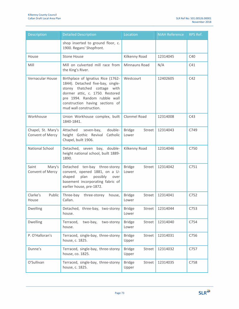
Kilkenny County Council Callan Draft Local Area Plan SLR Ref No: 501.00526.00001
November 2018
Page 73
Description Detailed Description Location NIAH Reference RPS Ref.
shop inserted to ground floor, c. 1900. Regans' Shopfront.
House Stone House Kilkenny Road 12314045 C40
Mill Mill on culverted mill race from the King's River.
Minnauns Road N/A C41
Vernacular House Birthplace of Ignatius Rice (1762‐1844). Detached five‐bay, single‐storey thatched cottage with dormer attic, c. 1750. Restored pre 1994. Random rubble wall construction having sections of mud wall construction.
Westcourt 12402605 C42
Workhouse Union Workhouse complex, built 1840‐1841.
Clonmel Road 12314008 C43
Chapel, St. Mary's Convent of Mercy
Attached seven‐bay, double‐height Gothic Revival Catholic Chapel, built 1906.
Bridge Street Lower
12314043 C749
National School Detached, seven bay, double‐height national school, built 1889‐1890.
Kilkenny Road 12314046 C750
Saint Mary's Convent of Mercy
Detached ten‐bay three‐storey convent, opened 1881, on a U‐shaped plan possibly over basement incorporating fabric of earlier house, pre‐1872.
Bridge Street Lower
12314042 C751
Clarke's Public House
Three‐bay three‐storey house, Callan.
Bridge Street Lower
12314041 C752
Dwelling Detached, three‐bay, two‐storey house.
Bridge Street Lower
12314044 C753
Dwelling Terraced, two‐bay, two‐storey house.
Bridge Street Lower
12314040 C754
P. O'Halloran's Terraced, single‐bay, three‐storey house, c. 1825.
Bridge Street Upper
12314031 C756
Dunne's Terraced, single‐bay, three‐storey house, co. 1825.
Bridge Street Upper
12314032 C757
O'Sullivan Terraced, single‐bay, three‐storey house, c. 1825.
Bridge Street Upper
12314035 C758

Kilkenny County Council Callan Draft Local Area Plan SLR Ref No: 501.00526.00001
November 2018
Page 74
Description Detailed Description Location NIAH Reference RPS Ref.
Dwelling Terraced, single‐bay, three‐storey house.
Bridge Street Upper
12314036 C759
Allied Irish Bank Terraced, four‐bay, three‐storey, classical style bank, c. 1900.
Green Street 12314003 C760
Callan Co‐op Attached, four‐bay, four‐storey warehouse, c.1850.
Green Street 12314002 C761
Post‐box Wall‐mounted, cast‐iron post box, between 1881‐1922.
Green Street 12314077 C762
Post‐box Freestanding cast‐iron pillar post box, between 1901‐10, with raised ER VII royal cipher.
Clonmel Road 12314063 C763
Callan Parochial House
Detached, three‐bay, two‐storey parochial house, c. 1900.
Clonmel Road 12314009 C764
Callan Motor Garage
Attached two‐bay, double‐height gable fronted motor garage.
Green Lane Lower 12314007 C765
Edmund Ignatius Rice, Monument
Freestanding limestone ashlar monument comprising tapered plinth.
Green Street 12314061 C766
Callan Garda Station
Detached three‐bay two‐storey Garda Siochana station, built 1926.
Green Street 12314006 C767
Flight of eight cut limestone steps
Flight of eight cut‐limestone steps, c.1875, with iron railings having cast‐iron tapered polygonal piers with finials.
Green Street 12314011 C769
Gateway, Catholic Church of the Assumption
Gateway, built 1854, comprising pair of square‐headed pedestrian gateways flanking central gateway
Green Street 12314064 C770
McDowell's Pharmacy
Terraced, four‐bay, three‐storey house, c. 1800. Possibly in use as a Royal Irish Constabulary Barracks, pre 1840
Green Street 12314012 C771
King TV Terraced, two‐bay, three‐storey house, c. 1825.
Green Street 12314013 C772
House Terraced, two‐bay, three‐storey house, c. 1875.
Green Street 12314014 C773
House Terraced, two‐bay, three‐storey Green Street 12314015 C774
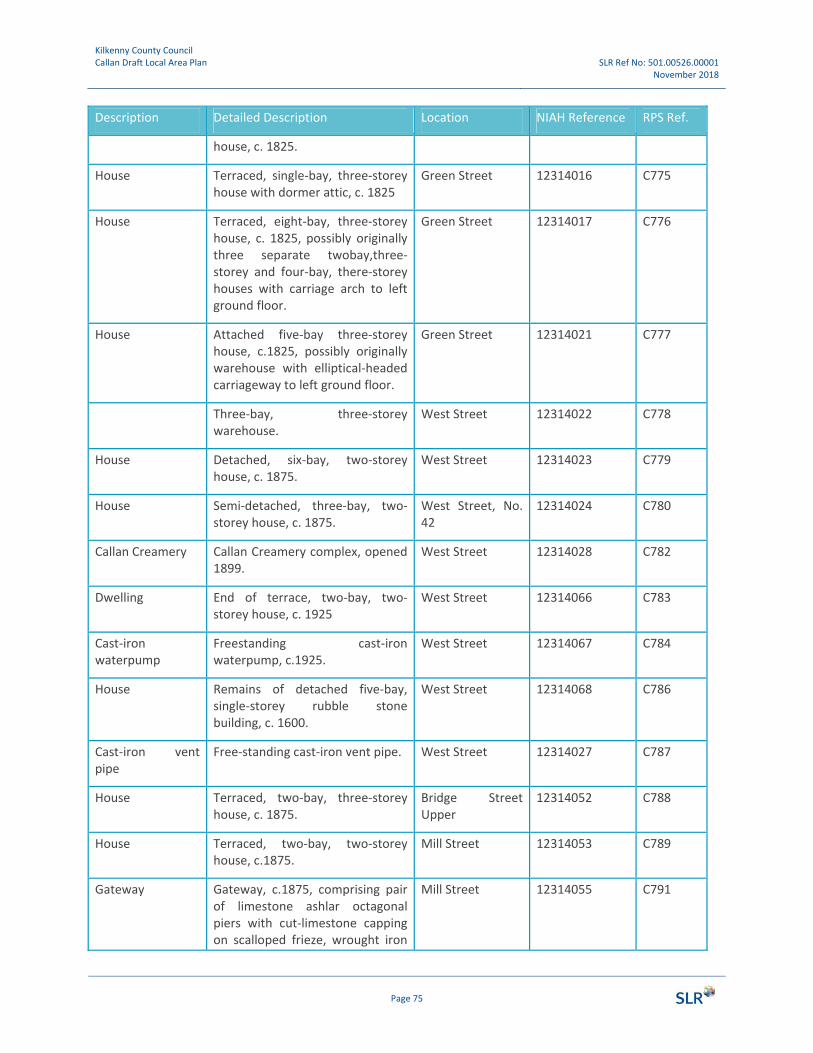
Kilkenny County Council Callan Draft Local Area Plan SLR Ref No: 501.00526.00001
November 2018
Page 75
Description Detailed Description Location NIAH Reference RPS Ref.
house, c. 1825.
House Terraced, single‐bay, three‐storey house with dormer attic, c. 1825
Green Street 12314016 C775
House Terraced, eight‐bay, three‐storey house, c. 1825, possibly originally three separate twobay,three‐storey and four‐bay, there‐storey houses with carriage arch to left ground floor.
Green Street 12314017 C776
House Attached five‐bay three‐storey house, c.1825, possibly originally warehouse with elliptical‐headed carriageway to left ground floor.
Green Street 12314021 C777
Three‐bay, three‐storey warehouse.
West Street 12314022 C778
House Detached, six‐bay, two‐storey house, c. 1875.
West Street 12314023 C779
House Semi‐detached, three‐bay, two‐storey house, c. 1875.
West Street, No. 42
12314024 C780
Callan Creamery Callan Creamery complex, opened 1899.
West Street 12314028 C782
Dwelling End of terrace, two‐bay, two‐storey house, c. 1925
West Street 12314066 C783
Cast‐iron waterpump
Freestanding cast‐iron waterpump, c.1925.
West Street 12314067 C784
House Remains of detached five‐bay, single‐storey rubble stone building, c. 1600.
West Street 12314068 C786
Cast‐iron vent pipe
Free‐standing cast‐iron vent pipe. West Street 12314027 C787
House Terraced, two‐bay, three‐storey house, c. 1875.
Bridge Street Upper
12314052 C788
House Terraced, two‐bay, two‐storey house, c.1875.
Mill Street 12314053 C789
Gateway Gateway, c.1875, comprising pair of limestone ashlar octagonal piers with cut‐limestone capping on scalloped frieze, wrought iron
Mill Street 12314055 C791

Kilkenny County Council Callan Draft Local Area Plan SLR Ref No: 501.00526.00001
November 2018
Page 76
Description Detailed Description Location NIAH Reference RPS Ref.
double gates having cast‐iron finials.
House Detached three‐bay, single‐storey house, c.1825, possibly originally rectory.
Mill Street 12314057 C792
House Terraced, two‐bay, there‐storey house, c.1825.
Green Street 12314018 C793
Pillar Post Box Free‐standing cast‐iron pillar box, c. 1925.
Mill Street 12314076 C794
House Terraced, two‐bay, three‐storey over basement house. C.1825 on a corner site.
Green Street 12314019 C795
House Terraced, there‐bay, three‐storey house, c.1825.
West Street 12314020 C796
House End of terrace, four‐bay, three‐storey house, c. 1825
Bridge Street Upper
12314030 C797
House Terraced, two‐bay, three‐storey house, c.1900.
West Street 12314029 C798
House Terraced, two‐bay, three‐storey house, C. 1850.
Bridge Street Upper
12314051 C799
Gateway Gateway, c.1850, comprising elliptical‐headed carriageway with cut limestone piers.
Mill Street 12314056 C802
Friary Attached, three‐bay, three‐storey friary, c.1825.
Mill Street 12314072 C803
Footbridge Three‐span footbridge over river, c.1925.
Over King's River 12314069 C804
Boundary wall, railings
Boundary wall, c.1800. Mill Street 12314075 C805
House Terraced single‐bay, three‐storey house, c.1825.
Bridge Street Upper
12314034 C806
House Attached, two‐bay, two‐storey building, c.1900 with shopfront to ground floor
Market Lane 12314060 C807
House Terraced, single‐bay, three‐storey house, c. 1825.
Bridge Street Upper
12314033 C808

Kilkenny County Council Callan Draft Local Area Plan SLR Ref No: 501.00526.00001
November 2018
Page 77
Description Detailed Description Location NIAH Reference RPS Ref.
House Terraced, two‐bay, three‐storey house, c. 1825.
Green Street 12314065 C809
Callan Courthouse Detached, five‐bay, two‐storey, Classical‐style courthouse, pre‐1840 attributable to William Francis Caldbeck (c. 1824‐1872) as evidenced by stylistic similarities with further courthouses associated with the architect across the county.
Green Street (E) 12314005 C25
Thatched cottage Farmyard complex, c.1825, including four‐bay, single‐storey thatched farmhouse with entrance windbreak on an elliptical plan
Callan South 12402601 C826
Total no. 76

21
5
3
4
3
1
2
1
4
4
2
3
5
3
3
3
PLAN BOUNDARY
ZONING OBJECTIVES
OPEN SPACE / GI
COMMUNITY FACILITIES
GENERAL BUSINESS
INDUSTRIAL
EXISTING RESIDENTIAL
LOW DENSITY RESIDENTIAL
NEW RESIDENTIAL
SPECIAL AREA OFCONSERVATION (SAC) GREENLINKS / BIODIVERSITY /CONSERVATION
AGRICULTURE
DEVELOPMENT OBJECTIVE
LEGEND
1NOVEMBER 2018
DateScale@ A31:8,000
ZONING PLAN
7 DUNDRUM BUSINESS PARKWINDY ARBOUR
DUBLIN 14IRELAND
T: 0129 64667www.slrconsulting.com
CALLANFOR INFORMATION
© This drawing and its content are the copyright of SLR Consulting Ltd and may not be reproduced or amended except by prior written permission. SLR Consulting Ltd accepts no liability for any amendments made by other persons.
0 100 200 300 400 500
MetresCalla
n Zon
ing P
lan 1.
7 Lan
dsca
pe
^
^
DEVELOPMENT OBJECTIVES
MASTERPLAN AREAS
KEY PROJECTS
DEVELOPMENT OBJECTIVES
1. West Street Mixed Use Development Area2. Mill Street Potential Redevelopment Arrea3. Rear of Bolton Wood4. Bolton Wood Employment Zone5. West Street / Chapel Lane Infill Area
1. Bridge Street / Mill Street Regeneration and Mobility Management Plan2. The Friary Conservation Plan3. Callan Motte Fields Amenity4. Callan Fair Green Re-development
1. St Mary's Pocket Park2. Junction Improvement3. N76 Development Buffer / Tree Planting4. Road Safety Audit5. Westcourt Road / Infrastructure Improvement
PEDESTRIAN-CYCLINGIMPROVEMENTS
ROAD IMPROVEMENTS

NEW PEDESTRIAN
BRIDGE LINK TO
MOTTE FIELDS
MIXED USE
DEVELOPMENT PROJECT
WITH PEDESTRIAN
LINKS TO BRIDGE ST
AND MOTTE FIELD
BRIDGE STREET / MILL
STREET REGENERATION AND
MOBILITY MANAGEMENT PLAN
CALLAN MOTTE
FIELDS AMENITY
MEADOW WALK
PARKLAND
ST. MARY'S
CLODINE LANE
(PEDESTRIAN
+ CYCLE ONLY)
NEW PEDESTRIAN
AND CYCLE BRIDGE
CANTILEVERED
RIVER WALKWAY
SAFE ROUTES TO SCHOOL
(IMPROVED LINKS
BETWEEN SCHOOLS AND
NEIGHBOURHOODS)
CYCLE + WALKING
ROUTES LINKING
NEIGHBOURHOODS IN
THE SOUTH OF CALLAN
THE FRIARY
CONSERVATION PLAN
DELIVER IN-RIVER
AND RIVERBANK
IMPROVEMENTS
MIXED USE DEVELOPMENT
PROJECT CENTRED ON
THE DELIVERY OF A
PEDESTRIAN/CYCLE WAY
ACROSS KINGS RIVER
PROPOSED
RIVER WALKWAY
PROPOSED
RIVER WALKWAY
Map 02: Bridge Street Masterplan
BUILDINGS
PUBLIC ROADS
PUBLIC OPEN SPACE
NATIONAL MONUMENT
KILKENNY RECORD
PROTECTED STRUCTURES
SPECIAL AREA OF CONSERVATION (SAC)
POTENTIAL PEDESTRIAN / CYCLE
ROUTE OPTIONS
LEGEND
Based on Ordnance Survey of Ireland Map Licence No. Kilkenny/CCMA/08/12
0 10 20 30 40m 60 80 100
Metres 1:1000 @ A3

EUROPEAN OFFICES United Kingdom
AYLESBURY T: +44 (0)1844 337380 BELFAST T: +44 (0)28 9073 2493 BRADFORD‐ON‐AVON T: +44 (0)1225 309400 BRISTOL T: +44 (0)117 9064280 CAMBRIDGE T: + 44 (0)1223 813805 CARDIFF T: +44 (0)29 20491010 CHELMSFORD T: +44 (0)1245 392170 EDINBURGH T: +44 (0)131 3356830 EXETER T: + 44 (0)1392 490152 GLASGOW T: +44 (0)141 3535037 GUILDFORD T: +44 (0)1483 889800
Ireland
DUBLIN T: + 353 (0)1 2964667
.
LEEDS T: +44 (0)113 2580650 LONDON T: +44 (0)203 805 6418 MAIDSTONE T: +44 (0)1622 609242 MANCHESTER T: +44 (0)161 8727564 NEWCASTLE UPON TYNE T: +44 (0)191 2611966 NOTTINGHAM T: +44 (0)115 9647280 SHEFFIELD T: +44 (0)1142455153 SHREWSBURY T: +44 (0)1743 239250 STAFFORD T: +44 (0)1785 241755 STIRLING T: +44 (0)1786 239900 WORCESTER T: +44 (0)1905 751310
France
GRENOBLE T: +33 (0)6 23 37 14 14