Embed Size (px)
Citation preview

Page 1Calculations of Hydrologic Design Peak Flows
Calculations of Hydrologic Design Peak Flows
Course Description
This course is designed to fulfill credit for the Professional Development Hours (PDH) of Civil Engineers. The objective of this course is to provide students with knowledge and experience using the National Streamflow Statistics (NSS) program which is developed by the United States Geological Survey. Students will learn how to use the NSS program to estimate flood-frequency statistics (e.g., 5-year or 100-year flood) for hydrologic basins in all states. The course will cover different procedures for NSS setup, input preparation and extracting results on flood peaks and other streamflow statistics. Automated procedure for input preparation using Geographical Information System (GIS) web-based tools is also covered.
Chapters
• Chapter 1: Introduction To Natural Streamflow Statistics (NSS)• Chapter 2: Overview of the NSS program• Chapter 3: Calculations and Estimations of Streamflow Statistics
Learning Objectives
Upon completion of the course, participants will be able to:• Understand basic concepts of streamflow, river stage, return period and design flood• Summarize the national streamflow gauging network operated by the U.S. Geological Survey (USGS)• Learn how to calculate return periods for different flood exceedance probabilities, and vice versa• Explain how to set up and run an NSS application scenario• Identify which variables are required by NSS for different states/regions• Create and produce graphical displays (hydrographs and frequency plots) based on NSS output• Summarize the fundamental equations used to compute flow peaks in rural and urban basins• Explain how to compute and interpret streamflow statistics for basins that cover multiple hydrologic regions• Interpret the different uncertainty measures produced by NSS

Page 2Calculations of Hydrologic Design Peak Flows
Chapter One:Introduction to Natural Streamflow Statistics (Nss)
Overview
• Definitions• How Floods are designated• Natural Streamflow Statistics (NSS) • Required Inputs for NSS Applications• The Main Output of NSS• Downloading and Installing the NSS Program
Learning Objectives
• Understand basic concepts of streamflow, river stage, return period and design flood
• Summarize the national streamflow gauging network operated by the U.S. Geological Survey (USGS)
• Learn how to calculate return periods for different flood exceedance probabilities, and vice versa
Definitions
The following are some definitions of basic concepts and terms that are necessary for understanding further material on estimation of flood peaks and streamflow statistics. (Source: The United States Geological Sur-vey; USGS)
Discharge (or streamflow)Discharge, or streamflow, is defined as the measured volume of water (usually expressed in cubic feet) that passes a certain point on the river or stream in a given amount of time (e.g., second, hour, or day). Discharge is usually expressed in cubic feet per second (cfs or ft3/s).
River StageStage is the height of the water in a river, measured relative to a certain datum. Measurements of river stage and streamflow are collected over numerous sites in the United States (Figure 1) by the U.S. Geo-logical Survey.
Figure 1: Locations of U.S. Geological Survey stream-gaging stations
HydrographA hydrograph is a plot that shows changes in discharge or river stage over a period of time. The period of time can be the duration of a storm given in days, months, year(s) or decade(s).
FloodA flood is a high discharge or streamflow value that overtops the natural or artificial banks or levees of a river.

Page 3Calculations of Hydrologic Design Peak Flows
Design FloodA design flood is the flood value that is chosen as the basis for the design of a hydraulic structure (e.g., a dam, a levee, a reservoir).
Design floods are usually specified for a certain design frequency (e.g., 5-year flood, 10-year flood, 100-year flood). The term “frequency” denotes the frequency of occurrence of a certain extreme event (e.g., a storm). The magnitude of an extreme event is inversely pro-portional to its frequency of occurrence. For example, extreme floods occur less frequently than moderate ones. The frequency of occurrence is closely related to the concept of “recurrence interval” or “return period”.
Recurrence interval or return periodThe recurrence interval or return period (T) is de-fined as the average number of years between floods of a certain size. The actual number of years between floods of any given size varies significantly because of the naturally changing climate.
Probability of ExceedanceThe return period (or recurrence interval), T, is related to another concept which is the probability of exceed-ance (p). In fact, T and p are reciprocals of each other:
Tp
pT 1and1
==
(1.1)
The following table lists standard design return peri-ods and frequencies:
Table 1.1: Standard levels of design return period and probability of exceedance
Return Period (T) Probability of exceedance (p)
2 0.5 (50%)
5 0.2 (20%)
10 0.1 (10%)
25 0.04 (4%)
50 0.02 (2%)
100 0.01 (1%)
For example, a flood that has a return period of 5 years (usually called 5-year flood) has a probability of ex-ceedance of 1/5 = 0.2, or exceedance frequency of 20%. Similarly, there is a 1% probability that a 100-year flood will be equaled or exceeded every year. It is noted that a 5-year flood is not the one that will necessarily be equaled or exceeded every five years. Instead, there is a 20 percent (20%) chance that this flood will be equaled or exceeded in any year. In fact, a 5-year flood could conceivably occur in several con-secutive years, with a 20% probability of recurrence on every year.
How floods are designated
The term “100-year flood” is a statistical designation and is used to indicate the chance (1-in-100) or prob-ability (1%) that a flood this size will occur during any given year. Scientists apply statistical techniques on long records of past floods to designate probability of exceedance of certain flood values.
Natural Streamflow Statistics (NSS)
These are basic flood-frequency statistics (e.g., 5-year or 100-year flood) for every State, for Puerto Rico, and for the island of Tutuila, American Samoa. Be-sides flood magnitudes of different return periods, streamflow statistics include other statistics, such as the mean annual and monthly flows, and low-flow fre-quencies. The low-flow frequencies represent lowest average flows that occur over a set number of con-secutive days (e.g. 3, 7 days) at defined recurrence in-tervals (e.g. 2, 10 years), for example 7-day 10-year low flow or 7-day 2-year low flow.
Applications of Streamflow StatisticsStreamflow statistics are used in a variety of design, plan-ning, and management and engineering applications:a. Design of culvert and other roadway hydraulic
structuresb. Flood control structuresc. Flood-plain management d. Setting water allocationse. Determining allowable waste dischargesf. Water quality regulation
Page 4Calculations of Hydrologic Design Peak Flows
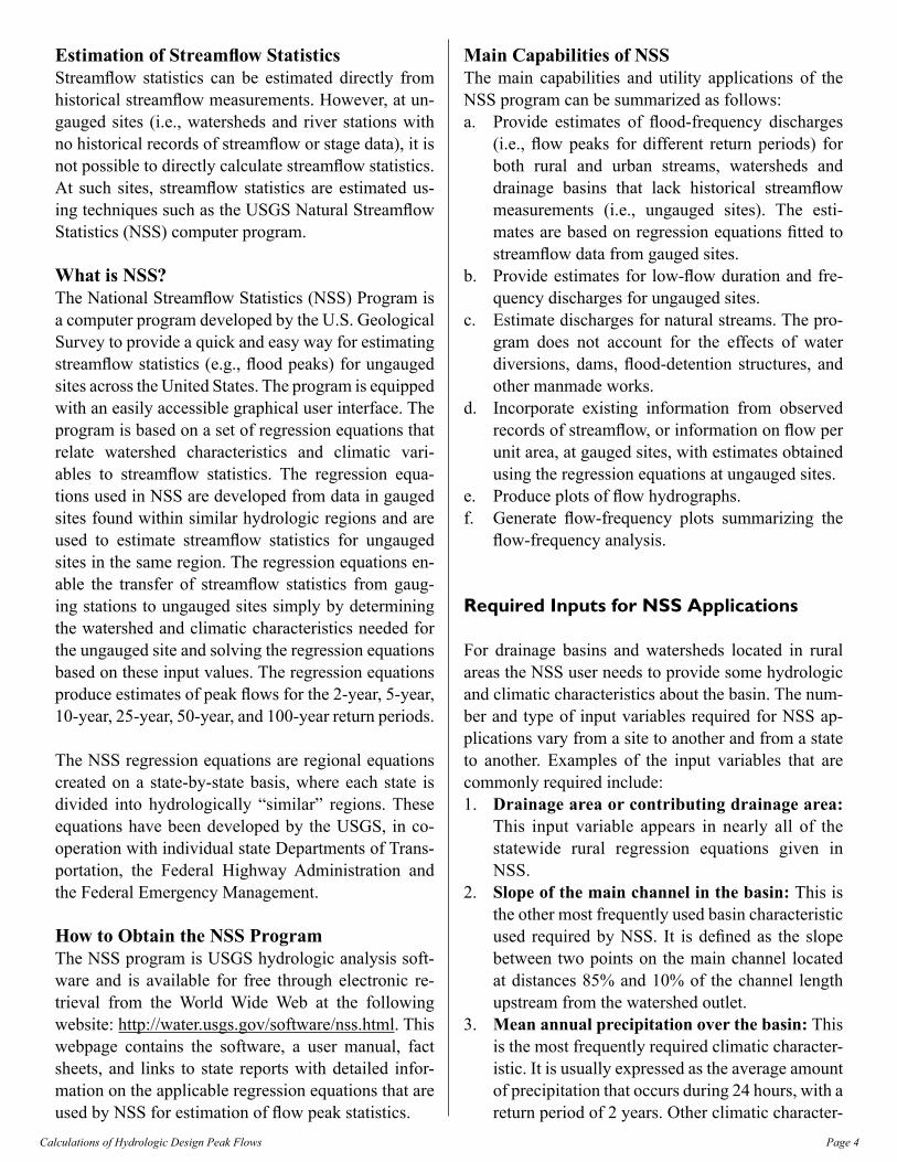
Estimation of Streamflow StatisticsStreamflow statistics can be estimated directly from historical streamflow measurements. However, at un-gauged sites (i.e., watersheds and river stations with no historical records of streamflow or stage data), it is not possible to directly calculate streamflow statistics. At such sites, streamflow statistics are estimated us-ing techniques such as the USGS Natural Streamflow Statistics (NSS) computer program.
What is NSS?The National Streamflow Statistics (NSS) Program is a computer program developed by the U.S. Geological Survey to provide a quick and easy way for estimating streamflow statistics (e.g., flood peaks) for ungauged sites across the United States. The program is equipped with an easily accessible graphical user interface. The program is based on a set of regression equations that relate watershed characteristics and climatic vari-ables to streamflow statistics. The regression equa-tions used in NSS are developed from data in gauged sites found within similar hydrologic regions and are used to estimate streamflow statistics for ungauged sites in the same region. The regression equations en-able the transfer of streamflow statistics from gaug-ing stations to ungauged sites simply by determining the watershed and climatic characteristics needed for the ungauged site and solving the regression equations based on these input values. The regression equations produce estimates of peak flows for the 2-year, 5-year, 10-year, 25-year, 50-year, and 100-year return periods.
The NSS regression equations are regional equations created on a state-by-state basis, where each state is divided into hydrologically “similar” regions. These equations have been developed by the USGS, in co-operation with individual state Departments of Trans-portation, the Federal Highway Administration and the Federal Emergency Management.
How to Obtain the NSS ProgramThe NSS program is USGS hydrologic analysis soft-ware and is available for free through electronic re-trieval from the World Wide Web at the following website: http://water.usgs.gov/software/nss.html. This webpage contains the software, a user manual, fact sheets, and links to state reports with detailed infor-mation on the applicable regression equations that are used by NSS for estimation of flow peak statistics.
Main Capabilities of NSSThe main capabilities and utility applications of the NSS program can be summarized as follows:a. Provide estimates of flood-frequency discharges
(i.e., flow peaks for different return periods) for both rural and urban streams, watersheds and drainage basins that lack historical streamflow measurements (i.e., ungauged sites). The esti-mates are based on regression equations fitted to streamflow data from gauged sites.
b. Provide estimates for low-flow duration and fre-quency discharges for ungauged sites.
c. Estimate discharges for natural streams. The pro-gram does not account for the effects of water diversions, dams, flood-detention structures, and other manmade works.
d. Incorporate existing information from observed records of streamflow, or information on flow per unit area, at gauged sites, with estimates obtained using the regression equations at ungauged sites.
e. Produce plots of flow hydrographs.f. Generate flow-frequency plots summarizing the
flow-frequency analysis.
Required Inputs for Nss Applications
For drainage basins and watersheds located in rural areas the NSS user needs to provide some hydrologic and climatic characteristics about the basin. The num-ber and type of input variables required for NSS ap-plications vary from a site to another and from a state to another. Examples of the input variables that are commonly required include:1. Drainage area or contributing drainage area:
This input variable appears in nearly all of the statewide rural regression equations given in NSS.
2. Slope of the main channel in the basin: This is the other most frequently used basin characteristic used required by NSS. It is defined as the slope between two points on the main channel located at distances 85% and 10% of the channel length upstream from the watershed outlet.
3. Mean annual precipitation over the basin: This is the most frequently required climatic character-istic. It is usually expressed as the average amount of precipitation that occurs during 24 hours, with a return period of 2 years. Other climatic character-

Page 5Calculations of Hydrologic Design Peak Flows
istics include mean annual average annual snow-fall, and minimum mean January temperature.
4. Mean basin elevation5. Estimates of basin coverage (e.g., percentage
of basin area covered by lakes, ponds, forests, etc.)
6. The following is an example of the NSS user interface used to enter the specific values of the input variables for a certain basin. Note that the number and type of input variables is a site and state-specific.
The user needs to come up with estimates for the input variables, most of which can be derived from topo-graphic maps, aerial photographs, and rainfall reports and atlases. Most of such information is available as digital data and can be derived using Geographical In-formation System (GIS). The USGS has developed an automated procedure for estimating basin character-istics and preparing input variables for NSS applica-tions. More detailed information about this automated system is provided later in the course.
For drainage basins and watersheds located in urban areas, there are typically seven input variables that the user needs to specify. These variables provide infor-mation on basin area, channel slope, average precipi-tation, basin’s storage capacity represented by percent-age of area occupied by lakes and ponds, degree of basin development and urban drainage improvements, and the percentage of area occupied by impervious surfaces in the basin.
The Main Output of Nss
The most typical output provided by the NSS program includes streamflow statistics (flood peaks) estimated for different return periods that range from 2 years up to 500 years. By default, the NSS output window dis-plays the following streamflow statistics information:
Where PK2, PK5, …., PK500 denote the estimated flood peaks for return periods of 2, 5, …, 500 years. The next two columns (Standard Error and Equivalent Years) provide some measures of the accuracy associ-ated with these estimates.
Besides the default tabular output, the user can pro-duce two types of plots: (a) a frequency plot, which shows the estimated flow peaks on the y-axis plotted against the corresponding return periods on the x-axis, and (b) a hydrograph plot, which shows a temporal distribution of the streamflow for any desired return period. For the hydrograph plots, the user also needs to provide an estimate of the basin’s time lag.

Page 6Calculations of Hydrologic Design Peak Flows
Finally, the NSS program generates a comprehensive report including detailed information about the per-formed analysis. Such information includes a summa-ry of the basin characteristics and the specific values of the input variables provided by the user, a list of the actual regression equations used to estimate the flood peaks, and other relevant information.
Downloading and Installing the Nss Program
The NSS program can be downloaded from the follow-ing Web page: http://water.usgs.gov/software/NSS/. This web page contains the software executable and database files, associated documentation, fact sheets, online reports and several related links. A help facility is included with the software.
Implement the following steps to download and install the NSS program:1. Go to web page http://water.usgs.gov/software/NSS/. 2. Download the latest executable file (as of June
2009, the latest executable file is called NSSv4.exe). This file contains the NSS Program Setup Wizard and the NSS computer program. Specify a folder on your computer hard drive to save the file.
3. Download the latest database file necessary for running the NSS program (as of June 2009, the latest database file is called NSS_v4_2009-04-08.mdb). This is a Microsoft Access data base needed to run the NSS program. Specify a folder (same folder where you save the executable file) on your computer to save the file.
4. Using Windows Explorer or My Computer, go the folder where you saved the NSSv4.exe file and double-click on it to start the NSS Setup Wizard.
5. Click “Next” in the Setup Wizard Welcome win-dow and specify the directory (default is C:\Pro-gram Files\NSS) in which NSS will be installed.
6. Select a folder in the Start menu where the pro-gram’s shortcut will be placed (default and recom-mended folder name is USGS).
7. Create and place a shortcut icon for the program on the desktop.
8. Start installing the NSS program and click on Fin-ish when the installation Wizard is complete.
9. Copy the NSS database file (NSS_v4_2009-04-08.mdb) to the NSS directory (C:\Program Files\NSS).
10. Check whether the installation is successful by starting the NSS program from the Start menu or from the shortcut icon on your desktop.
summary
This chapter introduced some basic concepts about streamflow statistics and their applications in design of engineering projects. The concepts on design floods, return period, frequency and probability of exceedance were introduced. The National Streamflow Statistics (NSS) program was introduced. The most common applications of the NSS program were discussed such as: design of roadway hydraulic structures, design of flood control structures, and determining allowable waste discharges. The Chapter also covered the main input information and variables required for an NSS, the most common of which is the area of the drainage basin or watershed under study. The main NSS output are estimates of peak flows and their corresponding hydrographs. A detailed procedure on how to obtain and install the NSS program from the USGS website was given.

Page 7Calculations of Hydrologic Design Peak Flows
Chapter Two:Overview of the Nss Program
Overview
• Main Components of the NSS Program• Main Windows and Functionality of
the NSS Program• Graphical Display of NSS Output• Combining Statistics from Different Regions• Sensitivity Analysis on the NSS Output
Learning Objectives
• Explain how to setup and run an NSS application scenario
• Identify which variables are required by NSS for different states/regions
• Create and produce graphical displays (hydrographs and frequency plots) based on NSS output
Main Components of the Nss Program
The NSS Program has four main components: 1. A user interface is the main interface of NSS,
which allows the user to interact with the program by entering input information and receiving and visualizing output results.
2. A calculation routine is the main engine of the program which includes regression equations used by NSS to compute the streamflow statistics based on basin and climatic characteristics speci-fied by the user through the user interface.
3. A database is where NSS stores all information it needs to perform the streamflow statistics, such as format and parameters of the regression equations and their error bounds.
4. A help facility: The NSS program provides on-line and offline help features such as user manual, help menu, access to web pages, etc.
Main Windows and Functionality of the Nss Program
The main user interface of NSS contains three pull-down menus: File: used to open projects and save analysis output and graphs; Graph: used to create graphical output such as flow hydrographs and fre-quency plots; and Help: used to provide access to help features. Below the pull-down menus are two boxes that allow the user to select the state in which the drainage basin is located and to give a name for the project.
The main NSS window is divided into two parts: the left frame is for rural analysis and the right frame is for urban analysis. Each of these two frames is equipped with a set of three buttons (Edit, New, and Delete) al-lowing the user to modify an existing NSS scenario, create a new one or delete the current scenario.
The top part of each frame displays the input informa-tion specified by the user on the site of interest. The lower part displays the output results, which mainly include the estimated flood peaks at different return periods with some information on the degree of uncer-tainty associated with such estimates.

Page 8Calculations of Hydrologic Design Peak Flows
By clicking on the New or Edit scenario buttons, a new window will open, which allows the user to enter the basin characteristics and other relevant informa-tion. The user needs to select a hydrologic region (or multiple regions) where the basin of interest is located, and specify the values of the input variables (reflecting hydrologic and climatic characteristics of the basin) that are required for analysis in each selected hydro-logic region. The program provides guidelines on the recommended ranges of such variables, within which the regression equations used to estimate streamflow statistics are most applicable.
This procedure can be used to create rural or urban scenarios; however, a rural analysis is required prior to performing an urban analysis.
After performing the streamflow estimation, the user has the option to produce text reports (by selecting File → Report from the main pull-down menu) and graphical presentations of the results (by clicking on Frequency Plot and Hydrograph at the bottom of the main window).
Finally, the Weight button can be used to incorporate information from gauged sites into the estimation of streamflow statistics at ungaged sites. This is done via statistical weighting either with actual observed data, or with values at other gauged sites.
An Example Application of NSSIn this section we will go through a tour session on how to setup and implement an example analysis of streamflow statistics estimation using the NSS pro-gram:
Start the NSS program from the Start menu (under USGS) or by double-clicking on the desktop shortcut icon. A new small window will open where the users can provide their name (optional) and specify a path and a name for their project. The user is also prompted to select which unit system (Metric or English) to be used in the project. Click Run to continue the session.
The main window of NSS will open. In this menu, se-lect a state where the project is located. In this exam-ple, select the state of Florida. Enter an optional name for the Project site. The window contains two sides, one for rural estimates and the other for urban esti-mates. Let us create two scenarios (rural and urban).
Click on “New” next to Rural to start a new scenario (by default it will have the name Rural 1). A new win-dow will open where you can specify input parameters for this scenario. First, we need to decide on which region in the state the project is located.

Page 9Calculations of Hydrologic Design Peak Flows
Calculations of streamflow statistics in the NSS pro-gram are based on dividing each state into various re-gions. For information on which region your project is located in, go to http://water.usgs.gov/osw/programs/nss/pubs.html. Click on the US national, and then click on the state of Florida.
Select the appropriate web link (in this case, select the link that points to “Estimating the Magnitude and Fre-quency of Floods for Streams in West-Central Florida, 2001”). On the left side of the page, click on the link “Figure 1 with links to individual stations”. This map helps the user identify which state region the project is located in. Let us assume that our project site is lo-cated in the domain of Region 1.
Go back to the NSS Edit Scenario Window and specify West-Central Region 1 as the region of this Rural 1 sce-nario. Based on this selection, a list of variables will be displayed. In this example case, the user is required to specify two variables: Contributing Drainage Area; and Percent of area occupied by Lakes and Ponds.
The window contains suggestions on ranges of these variables that are typically applicable in the selected re-gion. The user is supposed to provide input values of these variables. These input values can be computed from available maps or from other information avail-able about the study site. Automated procedures to cal-culate these variables are available through the use of Geographical Information System (GIS) or other USGS program (StreamStat; see Chapter 3). For our example, let us assume that the project drainage area is 1500 mi2
and that 3% of this area is occupied by ponds and lakes.

Page 10Calculations of Hydrologic Design Peak Flows
It is advised to save a copy of your NSS project file by clicking on File / Save As in the main window. Sav-ing is recommended after each change is made to the project scenarios.
Optionally, the user can also get probable maximum flood estimates based on the Crippen and Bue (1977) method (C&B method), which is available for 17 flood regions in the U.S. We first need to specify the flood region in which our project is located. Click on the Map button and a new figure will open. As you can see in this figure, our Florida example project is located in flood region # 3. Select “3” in the flood region box and click Ok.
The program will take you back to the main window where the output results of this scenario are displayed. The upper frame in the displayed window shows a summary of input variables and information provided earlier by the user. The lower frame displays the out-put statistics in terms of peak flow for different return periods (2, 5, 10, …,100, 200, 500 years). It also dis-plays an estimate of the uncertainty associated with the estimation of these peak flow statistics. Various measures of errors can be displayed based on the par-ticular method of estimation used by the NSS program over the specific site of the study. In this example, the
uncertainty is described by two measures: the aver-age standard error of prediction, expressed percent (%), and the equivalent years of record. More details on different measures of uncertainty available in the NSS program will be provided later. The last line in the results shows the probable maximum flood value computed based on the selected C&B region.
It is possible that the project site and its drainage area span (or cross) more than one region in the state. In this case, the user can select multiple regions. (Note: this is possible for computations of rural scenarios only.) The user needs to specify the drainage area as-sociated with each region in the appropriate boxes in the NSS window. The NSS window will display the entire drainage area (sum of sub-areas from different regions). For each region, the user will specify entries for the appropriate variables (each region may require a different set of variables).
Note that the results are being displayed based on combining the drainage areas in the two regions.

Page 11Calculations of Hydrologic Design Peak Flows
If desired, the same procedure can be repeated for an urban site. However, unlike the rural scenario, if an urban scenario is developed, only one region can be selected. Note that some urban calculations may de-pend on results from rural scenarios; in such cases, the rural scenarios need to be computed first.
The results will now be displayed in the left frame of the window (rural scenario) and the right frame of the window (urban scenario).
Graphical Display of Nss Output
After finishing setting up the scenarios, we can display the computed streamflow statistics graphically. Two types of graphs can be generated. The first one is a frequency plot which shows the computed flow peaks against their corresponding return periods. Click on the Frequency Plot button to generate frequency plots for the rural and urban scenarios. The frequency graph can be edited, saved and printed through a pull-down menu.
The second type of graphical display of the results is a hydrograph plot. Click on the Hydrograph box and a new window will open. The user can generate hy-drographs for a certain return period (recurrence inter-val) and for different scenarios. For each scenario, the lag time of the basin under consideration needs to be specified. In our example, let us specify the lag time as 6 hours for the rural scenario and 1 hour for the rural scenario and let us produce hydrographs for two return periods of 5 and 100 years. The hydrograph plot can be edited, saved and printed through a pull-down menu

Page 12Calculations of Hydrologic Design Peak Flows
The ordinates of the plotted hydrograph can also be obtained as numerical values by clicking on the List button. A time series of the generated hydrographs will be displayed and can be copied and pasted into an outside program (e.g. EXCEL) for further analysis.
You can also generate a text report containing the re-sults of your analysis. The report can be generated by selecting File/Report from the NSS main window and specifying a name for it. The report will contain detailed information about your project, input infor-mation about the study site, the equations that were used to calculate the streamflow statistics, the result-ing peak flow estimates, the uncertainty measures, and other relevant information.
Combining statistics from Different Regions
In the displayed report, one can see that the equations used for rural calculations in West-Central Region 1 were of the following form:
PK2 = 132 (CONTDA)0.528 (LAKEAREA+0.6)-0.542
Where PK2 is the 2-year peak flow, CONTDA is the contributing drainage area, and LAKEAREA is the percentage of area occupied by lakes and ponds.
Similar equations were used for West-Central Region 2 but with one more variable (CSL10_85) which rep-resents the stream slope:
PK2 = 2.03 (CONTDA)1.065 (CSL10_85)-0.017
(LAKEAREA+3)-0.259
The calculations are done for each region separately and then merged together according to the specified area-weight assigned for each region; for example, PK2 for region1 (1500 mi2) and region 2 (1000 mi2) were found to be 4100 cfs and 5240 cfs, respectively. The area-weighted average PK2 value is then calcu-lated as:
PK2 )(4556250010005240
2500150041002 cfsPK =+=

Page 13Calculations of Hydrologic Design Peak Flows
The rest of the calculations are done in a similar way as shown in the following table and figure (note that
this kind of analysis is only possible for rural basins):
Recurrence interval (year)
Computed peak Q in Region 1
(ft3/s)
Computed peak Q in Region 2
(ft3/s)
Area-weighted estimates
(ft3/s)2 4100 5240 45565 7280 10500 8568
10 9800 14700 1176025 13400 20600 1628050 16300 25200 19860
100 19500 30100 23740200 22700 35100 27660500 27700 42000 33420
0
5000
10000
15000
20000
25000
30000
35000
40000
45000
1 10 100 1000Return Period (year)
Peak
Flo
w (c
fs)
Computed peak Q in Region 1 (ft3/s) Computed peak Q in Region 2 (ft3/s)Area-weighted estimates (ft3/s)
sensitivity Analysis on the Nss Output
Let us try to perform some analysis on the sensitiv-ity of the computed streamflow statistics to the basin characteristics. For rural areas, we can examine the ef-fect of percentage of the total area occupied by lakes and ponds. For this test, let us assume that our drain-age area is entirely located in West-Central Region 1. We will run the NSS program using two different values of the variable that represents the percentage of total area occupied by lakes and ponds: 3% and 8%. This represents a situation where a reservoir, or a detention pond, was introduced in the drainage basin to increase the area occupied by such coverage from 3% to 8%. As expected, the effect of increasing the “storage” capacity of the drainage basin will lead to a reduction in the peak flows as shown in the following table and figure:
Recurrence interval (year)
Computed peak Q with 3% lakes/pond area (ft3/s)
Computed peak Q with 8% lakes/pond area (ft3/s)
2 3130 19505 5610 3530
10 7590 476025 10400 652050 12700 7930100 15300 9460200 17900 11000500 21900 13400
0
5000
10000
15000
20000
25000
1 10 100 1000
Return Period (years)
Peak
FLo
w (c
fs)
Area of Lakes & Ponds = 3% Area of Lakes & Ponds = 3%
Another sensitivity test can be performed on the ur-ban basin. We can test the effect of increased urban-ization by changing the percentage of area occupied by impervious surfaces (variable Area-of-Impervious-Surfaces) from 25% to 50%. After running the NSS program with these two scenarios, the peak flows at different return periods can be compared. As expected, increased urbanization in the basin leads to an increase in the peak flows at every return period as shown in the following table and figure:
Recurrence interval (year)
Computed peak Q with 25%
impervious surface (ft3/s)
Computed peak Q with 50%
impervious surface (ft3/s)
2 426 895
5 755 1450
10 1060 1940
25 1570 2720
50 2040 3410
100 2640 4250
500 4570 6870

Page 14Calculations of Hydrologic Design Peak Flows
0
1000
2000
3000
4000
5000
6000
7000
8000
1 10 100 1000
Return Period (years)
Peak
FLo
w (c
fs)
Impervious Surface = 25% Impervious Surface = 50%
summary
In this chapter, an overview of the four main compo-nents (user interface, calculation routine, database, and help interface) of the NSS program was provided. The main windows and functionality of the program were described. A full example of the NSS application including various scenarios was presented. The NSS can be applied for rural as well as urban drainage ba-sins (a rural analysis is required prior to performing an urban analysis). Different number and types of input variables are needed by NSS depending on the drain-age basin type (urban versus rural) and the hydrologic region and state in which the basin is located. The NSS program provides an automated way for specifying the required input variables. While a typical NSS sce-nario includes a drainage basin that is entirely located within a single hydrologic region, the program also allows for analyzing basins that cross boundaries of more than one region (possible for rural basins only). In such cases, an average based on area weighting is applied. The chapter also covered the main output of NSS, which includes tables of flow peaks for differ-ent return periods as well as graphical displays of fre-quency plots and streamflow hydrographs. To display a streamflow hydrograph plot, the user needs to spec-ify the lag time of the basin. Finally, we also learned how to study the sensitivity of streamflow statistics (e.g. peak flows) to the characteristics of the drainage basin (e.g. effect of increased urbanization; effect of increased basin’s detention capacity).

Page 15Calculations of Hydrologic Design Peak Flows
Chapter Three:Calculations and Estimations of Streamflow statistics
Overview
• Regression Equations in NSS• Equations for Rural Basins• Hydrologic Regions in NSS• If the Drainage Basin Crosses Two (or more)
Hydrologic Regions• Measures of Uncertainty in NSS Peak Flow
Estimates• Estimation of Flood Hydrographs in NSS• Preparation of NSS Input • Using StreamStat Web-Application for
Preparation of NSS Input • Feeding StreamStats Output into NSS• Using StreamStats to Generate Streamflow
Statistics
Learning Objectives
Upon completion of the course, participants will be able to:• Summarize the fundamental equations used to
compute flow peaks in rural and urban basins• Explain how to compute and interpret streamflow
statistics for basins that cover multiple hydrologic regions
• Interpret the different uncertainty measures pro-duced by NSS
Regression Equations in Nss
The National Streamflow Statistics (NSS) Program pro vides a methodology for estimation of streamflow statistics (peak flows; low flows for different return periods or recurrence intervals) in ungauged sites that lack records of historical flows. The program is based on a set of regression equations that were developed for gauged sites with long historical records of stream-flow measurements. Hydrologic regions that represent areas of relatively homogeneous streamflow charac-teristics are identified and regression equations are de-veloped from data of gauged sites within each region. These equations are found by fitting peak flows from gauged sites to watershed and climatic characteristics of these sites. Then, for an ungauged site in a certain region, the regression equations of that region are used to estimate streamflow statistics using watershed and climatic characteristics of the site.
A typical regression equation will have the following form:
neneeee
T XXXXaXQ ..........43214321=
(1.1)
Where QT is the peak flow for a certain return period T (T is in years), X1, X2, X3,…, Xn, are watershed and cli-matic characteristics (e.g., drainage area, main chan-nel slope, mean precipitation, etc.), and a, e1, e2, e3,…., en, are regression coefficients.
The NSS equations depend on the type of watershed under examination (rural or urban). For rural areas, the number and type of input variables (X1, X2, X3,… Xn) and the number of regression coefficients (e1, e2, e3,…., en) vary from a state to another and within dif-ferent hydrologic regions in the same state. For urban watersheds, a nationwide set of equations is used with the option of using a site-specific or local equation if available.
Equations for Urban Basins
In the case of urban basins, the NSS program uses na-tionwide equations with seven parameters (exponents) to calculate urban peak discharges, UQ, for different return periods, T. A typical form of such equations is as follows:

Page 16Calculations of Hydrologic Design Peak Flows
UQ(T=2year) = 2.35 A0.41SL0.17 (RI2+3)2.04 (ST+8)-0.65(13-BDF)-0.32IA0.15 RQT=2year
0.47
UQ(T=2year) = 2.35 A0.41SL0.17 (RI2+3)2.04 (ST+8)-0.65(13-BDF)-0.32IA0.15 RQT=2year
0.47
Where UQ is the urban peak discharge (ft3/sec), A is the contributing drainage area (mi2), SL is the slope of the main channel (ft/mi), RI is the rainfall depth (inch) for a 2-hour, 2-year return storm, ST is a measure of the storage in the basin (estimated as the percentage of the basin area occupied by lakes, reservoirs, swamps, and wetlands), BDF is a factor that accounts for ur-ban drainage improvements in the basin, IA is mea-sure of the degree of urbanization in the basin and is represented by the percentage of the drainage basin occupied by impervious surfaces (e.g., houses, park-ing lots, streets, etc.), and RQT is the equivalent dis-charge (ft3/sec) for a rural basin having the same area and estimated for the same return period as of that of the urban basin.
Similar equations are available for other return peri-ods between 2 and 100 years. The values of param-eters in such equations vary according to the specified return period.
The above seven-parameter urban flood-frequency equations can be used in urban drainage nationwide; however, the user can also use local or state-specific equations that have been included in the NSS pro-gram. These additional equations are site-specific and should not be used for urban areas other than those that they were developed for.
It is noted that these seven-parameter equations should not be used to calculate flood-frequency values in ba-sins where flow is modified or controlled by reservoirs or deten tion basins.
Equations for Rural Basins
For basins located in rural areas, the number and type of input variables (X1, X2, X3,.. Xn) and the number of regression coefficients (e1, e2, e3,…., en) vary from one state to another and within different hydrologic regions in the same state. For example, in hydrologic region # 2 in Central Florida, the contributing drain-age area (DA), the main channel slope (SL), and the percent of the total drainage area covered by lakes
(LK), provided the best regression models for this re-gion. An example of such equations for a 5-year return period peak flow is as follows:
(SL) 0.339-3.0)(LK (DA) 5.82 (cfs) Q 0.1491.023
5 +=
(1.2)
Another example is in hydrologic region # 4 in the state of Utah where the 100-year flood is predicted us-ing information on drainage area (DRNAREA mile2), basin mean elevation (ELEV, ft), and average basin slope (BSLDEM10M, percent):
MBSLDEMELEVDRNAREAcfsQ 10023.0)000,1/(334.0792.0100 72.218.4)( −=
MBSLDEMELEVDRNAREAcfsQ 10023.0)000,1/(334.0792.0100 72.218.4)( −=
(1.3)
The following Table shows a list of different watershed and climatic variables that are used by the various re-gression equations within the NSS program. It should be noted that not all of these variables are used in every regression equation or every hydrologic region.
Drainage area or contributing drainage areaMain-channel slopeMean annual precipitationSurface water storage (Lakes, ponds, swamps)Rainfall amount for a given durationElevation of watershedPercent of Forest coverChannel lengthMinimum mean January temperature Soils characteristicsMean basin slope Mean annual snowfallRunoff coefficientMean annual runoff (inches)Normal daily May-March temperatureImpervious Cover (percent)Annual Potential evapo-transpirationBasin shape (length)2 per drainage area)
Hydrologic Regions in Nss
The regression equations used by the NSS program to estimate streamflow statistics in ungauged sites are de-veloped for distinct regions that represent areas of rela-

Page 17Calculations of Hydrologic Design Peak Flows
tively homogeneous streamflow characteristics. These are known as hydrologic regions. On average, there are about four hydrologic regions per state (see figures be-low for two examples in Texas and California). These regions were determined by using major watershed boundaries and information on the mean elevation of the watershed. It is noted that some states have inad-equate data to define streamflow relations in some re-gions (e.g., Florida, Georgia, and South Carolina).
Figure 1: Flood-frequency region map for California.
If the Drainage Basin Crosses Two (or more) Hydrologic Regions
It is possible that the drainage basin under consider-ation lies within an area that crosses two hydrologic regions. There are two possible cases: a. The basin boundary crosses more than one hydro-
logic region in the same state.b. The basin boundary crosses more than one hydro-
logic region that spans neighboring states.
In the first case, NSS has an automatic way for es-timating the streamflow statistics for a basin that crosses two hydrologic regions within the same state. Let us assume that total area of the drainage basin is At, part of it, A1, lies in a certain hydrologic region, and the other part, A2, is located in another region but within the same state (At=A1+A2). The procedure for calculating the streamflow statistics (e.g., peak flows at different return periods) is as follows: First, NSS estimates streamflow statistics for the basin as if it was entirely located within each of the two regions. Then, NSS applies a weighting average of the two stream-flow estimates based on the percentage of the basin area within each hydrologic region. The following is an example of how the weighting is done:
t
regionTt
regionTT AAQ
AAQQ 2
)2#(1
)1#( +=
Where QT is the area-weighted-average peak flow for a certain return period T, QT(region#1) is the peak flow esti-mated assuming the total drainage area located within region # 1, and QT(region#2) is the peak flow estimated as-suming the total drainage area located within region # 2. Similar equations can be written if the drainage area spans more than two regions (e.g., n number regions). A general form of this equation is:
∑=
=
=ni
i tiregionTT AAiQQ
1)#(
This procedure is implemented automatically in NSS. The user needs to specify the different hydrologic re-gions crossed by the basin of interest along with infor-mation on the percentage of the basin’s area located within each region. The following figure is an exam-ple of the NSS interface showing the selection of three

Page 18Calculations of Hydrologic Design Peak Flows
regions crossed by a single basin. Note that the num-ber of input variables needed for every region crossed by the basin may not be the same from one region to another; in this case, the user needs to specify the in-put variables that apply for each region accordingly.
In the second case (b), a similar procedure is followed when the drainage basin crosses the boundaries of two or more states. However, unlike case (a), NSS doesn’t perform the weighting of cross-state basins automati-cally; instead, the user must perform this procedure manually. In such situations, the user will need to use NSS for each state separately using the entire drainage area of the basin. Then, the user applies a weighting scheme to estimate the peak flow based on the per-centage of the basin’s drainage area in each state. For example, if the basin crosses two states (A1 in the first state and A2 in the neighboring state), then average peak flow estimate is:
t
stateTt
stateTT AAQ
AAQQ 2
)2#(1
)1#( +=
Where QT(state#1 or 2) is the peak flow estimated as if the drainage basin was entirely located in each of the two states.
Measures of Uncertainty in Nss Peak Flow Estimates
Like most statistically-based estimation methods, the streamflow estimates provided by NSS are inevitably subject to varying degrees of uncertainty and estima-tion errors. The degree of uncertainty (or accuracy) of the NSS streamflow statistics varies from site to site depending on the values of the independent variables (e.g., basin’s hydrologic and climatic characteristics) specified by the user as input into the NSS regression equations. Note that the NSS regression equations were originally derived and fitted for certain ranges of input variables. Therefore, basins with characteris-tics within such ranges will have higher accuracy for
the estimated streamflow statistics, and vice versa. In-formation about the degree of uncertainty is provided as an NSS output within the same window where the streamflow statistics are displayed.
The NSS program reports the streamflow accuracy us-ing different descriptive measures: 1. Average standard error of estimate (%): This
provides a measure of the average variation be-tween the streamflow estimates based on the re-gression equations and the corresponding values derived from the gauging data for those stations used to develop the regression equations. The larger this number is, the less accurate the esti-mated flood peaks are.
2. Average standard error of prediction (%): This is a more reliable (and preferred) measure of the average accuracy of the regression equa-tions when applied to estimate flow statistics for ungauged sites. The average standard error of pre-diction is usually a few percent higher than the average standard error of estimate. The larger this number is, the less accurate the estimated flood peaks are.
3. Equivalent years of record (years): This is an-other measure of accuracy and represents the number of years of “actual” streamflow historical record required to achieve the same accuracy as the regional regression equations. The larger the equivalent years of record required is, the less ac-curate the estimated flood peaks are.
4. Prediction intervals (cfs): This is another way used in recent NSS analysis to specify the accu-racy of the streamflow statistics. In general, pre-diction intervals indicate the probability that the true peak flow value for a certain site is within the given prediction interval. For example, if the 90% prediction interval for a 10-year peak flow at a certain site is specified as 340-445 cfs, this simply means that there is a 90% confidence that the true 10-year flood is between 340 and 445 cfs. Apparently, the narrower this interval is, the more accurate the estimated flood peak is.
The following are some important remarks that the NSS user should be aware of when interpreting the accuracy of the estimated streamflow statistics:a. In the NSS user interface, the average standard er-
ror of estimate is given under a head ing named

Page 19Calculations of Hydrologic Design Peak Flows
“Estimation error, %,” while the average standard error of prediction is given under a heading named “Prediction error, %.”
b. The standard errors of estimate are provided by NSS only when the standard errors of prediction are not available in the individual statewide re-ports.
c. For most flood peak equations, the standard er-rors of estimate or prediction range from 30–60%. Few equations have smaller errors near 15% and some equations have errors greater than 100%.
d. The applicable ranges of basin hydrologic and climatic characteristics originally used to fit the regression equations are shown in the NSS user interface. A warning is given to the user of NSS when specifying input variables that are outside of such applicable ranges. If the users decide to proceed with using basin characteristics that are outside the applicable ranges, the streamflow es-timates are said to be extrapolated. It is noted that the accuracies of extrapolated estimates are un-known; therefore, the users are advised to be care-ful with using such estimates in any further design or planning applications.
e. The eastern parts of the nation have equations with the smallest flood-peak standard errors, while the western and southwestern parts are character-ized with the largest standard errors. This is usu-ally related to various factors such as: length of streamflow historical records used in developing the regression equations, density of gauging sta-tions, natural variability and effects of seasonal variation and sensitivity of streamflow to climatic and hydrologic drivers, and increased sensitivity to relief and aspect that are more pronounced in the west.
Estimation of Flood Hydrographs in Nss
While the NSS program is mainly used to estimate flood peaks for different return periods, it can also be used to compute a hydrograph that represents aver-age streamflow for a specified flood peak. This repre-sentative hydrograph is considered an average design hydrograph that can be used for some design appli-cations, but should not be a representative of any par-ticular rainfall distribution.
The NSS program uses the dimensionless hydrograph method to estimate flood hydrographs. To develop a hydrograph for a site or a watershed under consider-ation, the user needs to provide two pieces of infor-mation. The first is the peak flow value, which can be selected from the frequency output table produced by NSS. The second required variable is the basin lag time (LT). The lag time is a measure of the response time at the outlet of a watershed to a rainfall event. There are several methods and equations for calculat-ing the basin lag time for rural and urban watersheds that vary by state, type of equation, and the required input variables. The NSS manual provides a state-by-state summary of these different equations (See Ap-pendix B in the NSS user manual).
For the most part, the lag time (LT) depends on char-acteristics such as:• Drainage area • Main channel length and slope• Peak discharge• Mean annual precipitation• Land use coverage in the watershed (e.g., percent
of area covered by forest, impervious surface, etc.)• Percent of storage area in the watershed
An example of such equations is the one used in Mis-souri for rural watersheds:
0.1950.39 -S 2.79L LT =
Where LT is the lag time (hour), and L (mile) and S (feet/mile) represent the length and slope of the main channel in the watershed, respectively.
In the case of urban watersheds, the NSS Program computes the hydrograph based on dimensionless hy-drograph ordinates stored in the program. In this case, the lag time can be estimated by specifying the basin length in miles. However, for rural watersheds, the NSS doesn’t have lag time equations currently stored and therefore the user needs to come up with an esti-mate for LT.

Page 20Calculations of Hydrologic Design Peak Flows
Preparation of Nss Input
The input variables needed to solve the regression equations can be obtained from various resources (e.g., maps, aerial photographs, atlases, Geographic Infor-mation System (GIS) data layers, statewide flood-fre-quency reports). Some of these reports and informa-tion are included on the NSS website; however, users may need to consult original reports or specific site information to obtain some of the input variables for the regression equations in their particular application. The estimation of input variables for a certain project site can be quite laborious and may involve a lot of manual work; therefore, the USGS has developed a web application known as StreamStats that automates this process and can be used to prepare input for the NSS computations.
Using streamstat Web-Application for Preparation of Nss Input
Overview of StreamStatThe process of estimating streamflow statistics for un-gauged sites using the NSS program involves several manual operations, especially those associated with estimating the input variables that go into NSS (e.g., watershed characteristics). An automated procedure, known as StreamStats, based on web applications has been developed by the USGS to automate the entire process. While this automated process is fast, more efficient, and probably more accurate than manual methods for estimating the NSS input variables and output statistics, the StreamStat program is not avail-able for all states in the United States. The map shown below indicates the specific states for which Stream-Stat is available. Based on collaboration with state and local agencies, the USGS plans to eventually extend StreamStat availability throughout the nation. More information on the StreamStat can be found on the StreamStats Web page at http://streamstats.usgs.gov/.
Implementation Status of the StreamStat USGS Program
The following is a summary of the key features and functionality of the StreamStat program:• Using a web-browser, the user has access to a map-
based user interface showing different states, their hydrologic basins and sub-basins.
• The user can select a certain ungauged site by clicking on it in the map.
• A web-application GIS program delineates the boundaries of the drainage basin.
• If needed, the user has the option to edit the bound-aries of the watershed.
• The physical characteristics of the selected drain-age basin, which are needed for the regression NSS equations, are computed by StreamStat.
• The computed physical characteristics are fed auto-matically into the NSS program to estimate stream-flow statistics for the selected site.
• The results are displayed in the web browser window.• The StreamStat application provides the capability
to download basin boundary shape files and print maps shown in the user interface.

Page 21Calculations of Hydrologic Design Peak Flows
Example Application of StreamStat1. Go to the StreamStat website at: http://water.usgs.
gov/osw/streamstats/index.html.2. Click on “State Application” on the left-side
menu.3. Choose a state of interest (Tennessee in this ex-
ample).4. Click on “Interactive Map”; the following win-
dow will open showing the state map and its main topographic and boundary features.
5. Use the zoom-in tool on the top menu. Keep zooming onto the site of interest. Keep zooming until you reach a scale (displayed at the bottom) of 1:2000 or less. You can also use the scale scroll-bar to zoom into a certain area and scale. Assume you navigated and zoomed into your site of inter-est. If you zoomed in enough, you should see a link that says “Basin Delineation” activated.
6. Click on “Basin Delineation” and click on the stream location that represents the outlet of your watershed or drainage basin. The StreamStat web application will perform the stream delineation ap-plication (it may take a few minutes) and prompts you to confirm the results. The drainage boundary of the delineated basin is now displayed.
7. Click on “Basin Char” to select and display the physical characteristics of the delineated basin.

Page 22Calculations of Hydrologic Design Peak Flows
8. Select all characteristics and click on “Compute Characteristics”; the results are now displayed for the basin.
Feeding StreamStats Output into NSSThese characteristics can now be used as input to the NSS program to compute the desired streamflow sta-tistics, generate flood-frequency plots, and produce hydrographs. 1. Start a new session for NSS and choose Tennessee
as the state of your site.2. Set up a new “Rural” scenario by clicking on
“New.”3. Our site falls in region “MultiVariable_Area_3_
CDA_LT_30.2”.4. Enter the site characteristics that you obtained
from the StreamStats program; namely: 5. Contributing_Drainage_Area = 0.25 square miles.6. Stream_Slope_10_and_85_Method = 228 feet per
mi. 7. Continue by computing the peak flow statistics.
You can also generate a peak-flow plot by clicking on “Frequency Plot.”
A hydrograph can be generated by clicking on “hydro-graph” after specifying the basin lag time (select 0.1 hours as an example):

Page 23Calculations of Hydrologic Design Peak Flows
Using streamstats to Generate Streamflow Statistics
Alternatively, StreamStat can produce some of these calculations such as the streamflow statistics (but without plots). To do that, click on “Flow Stats” to compute the streamflow statistics of the selected basin.
It is noted that StreamStats cannot be used to estimate peak flows in urban streams. This is because equations used for urban streams require an input variable that specifies basin development conditions (basin devel-opment factor). StreamStats and its GIS features can-not estimate this factor.
summary
This chapter covered the regression equations used by NSS to estimate flow peaks for different return peri-ods. Two types of equations were presented: rural and urban. For rural basins, the format and number of in-put variables in these equations vary from one state to another and within different hydrologic regions in the same state. However, the most common input variables are drainage area, channel slope, basin ele-vation, among others. For urban applications, a seven-variable nationwide equation is most commonly used. The chapter also emphasized the uncertain nature of NSS streamflow output and explained the four differ-ent uncertainty measures computed by the NSS pro-gram. Finally, another pre-processing software pro-gram, StreamStat, was introduced -- it supports NSS applications and facilitates NSS input preparation. StreamStat is a GIS web-based application that pro-vides an automated procedure to compute basin and climatic characteristics and other relevant information necessary for NSS applications in ungauged sites. It can also be used to solve regression equations and ob-tain streamflow statistics.

Page 24Calculations of Hydrologic Design Peak Flows
1. The NSS program can be used to compute flow peaks for _____.a. All types of streamsb. Urban streams only c. Natural streams onlyd. Streams that have been modified with hydraulic
control structures
2. The term “100-year flood” is a statistical designation and is used to indicate the chance (1-in-100) or probability (1%) that a flood this size will occur ____.a. During any given yearb. Every yearc. Every year in the next 100 yearsd. One year in the next 100 years
3. The magnitude of the peak-flow for a certain basin is expected to _______ with the increase of the design return period. a. Decreaseb. Remain the samec. Increased. Vary
4. The lag time is a measure of the _____________.a. Response time of a watershed to a rainfall eventb. Time between a rainfall event and the
corresponding floodc. Time to peak-flow d. Duration of a flood event
5. The most commonly required input variable for NSS applications is: a. Area of the drainage basinb. Perimeter of the drainage basinc. Climatic characteristics over the drainage basind. Stream size
6. The NSS program combines statistics from different hydrologic regions using weights based on:a. Return periodb. Magnitude of flow peaksc. Stream length in each regiond. Sub-area located in each region
7. In interpreting the equivalent years of record as a measure of uncertainty, a smaller value of this measure implies that:a. The estimated flood peaks are less accurateb. The estimated flood peaks are more accuratec. The NSS analysis is completely unreliabled. None of the above
8. The lag time for a hydrologic basin depends on:a. Drainage area only b. Length and slope of main channelc. Land use coverage and percent of storage area
in the basind. All of the above
9. The seven-parameter urban NSS equations can be used to calculate flood-peak values: a. In all basinsb. Only in basins where flow has not been
modified or controlledc. In rural basins as well d. Only for certain return periods
10. Compared to basins located in the eastern parts of the nation, basins that are located in southwestern parts are characterized with ________.a. Same accuracyb. Higher accuracyc. Lower accuracy d. Comparable accuracy
Calculations of Hydrologic Design Peak Flowsstudent Assessment
Select the best answer for each question and complete your test online at www.keepingyouinformed.com.
Final Exam