Embed Size (px)
Citation preview

Cabrillo NM: Shadows of the Past
http://www.nps.gov/history/history/online_books/cabr4/index.htm[10/23/2012 2:19:49 PM]
CABRILLO
Shadows of the Past
SHADOWS OF THE PASTat Cabrillo National Monument
Roger E. KellyRonald V. May
National Park ServiceCabrillo National Monument, San Diego, CA.Pacific Great Basin Support Office, Oakland,
CA.
2001
TABLE OF CONTENTS
cabr/shadows/index.htmLast Updated: 06-Apr-2005
Cabrillo NM: Shadows of the Past (Table of Contents)
http://www.nps.gov/history/history/online_books/cabr4/contents.htm[10/23/2012 2:19:53 PM]
CABRILLO
Shadows of the Past
TABLE OF CONTENTS
Cover
Preface
Executive Summary
List of Illustrations
Chapter One: Shadows of the Past at Cabrillo National Monument
IntroductionLegacy from the Geological PastLife on the LandEstablishment of the MonumentNative Peoples of Point Loma PeninsulaHistoric Land UsesHistorical Archeology of Early LandscapesArcheological Materials in Park CollectionsPrevious Archeological Research in the Point Loma LocalityTerrain Assessment Surveys and ExcavationsCondition of Archeological Sites
Chapter Two: Overview of Point Loma Prehistory
IntroductionLaws and RegulationsAcademic Research SchoolsPaleogeography of the San Diego CoastArcheology Sites as Time CapsulesResearch DesignIntra and Inter-Site Patterning QuestionThe Inter-Site Settlement Research QuestionSpecific Research Hypotheses for Point Loma Sites
Chapter Three: Overview Spanish and Mexican History of San Diego & Point Loma
IntroductionEarly Spanish ExplorationsSpanish Colonization of CaliforniaSpanish Response to Foreign IncursionsSpanish Defenses on Point LomaThe First Point Loma LightSpanish Instability and illegal Foreign TradeThe Mexican Republic

Cabrillo NM: Shadows of the Past (Table of Contents)
http://www.nps.gov/history/history/online_books/cabr4/contents.htm[10/23/2012 2:19:53 PM]
The Mexican War of 1846The Ethnic and Gender Mix
Chapter Four: Overview of the Multi-Ethnic Ballast Point Community on Point Lomabetween 1846 and 1900
IntroductionEconomic and Ethnic DiversityHistorical RecordArcheological BackgroundRelationship of Ballast Point and La Playa to Other CommunitiesEducational OpportunitiesConclusion
Chapter Five: Overview of Historical Military Architecture at Point Loma
IntroductionHistoric Architecture as Historical and Archeological ResourcesArchitecture and Infrastructure as Industrial ArcheologyVertical Sequential Layering of Historic and Architectural FeaturesInternal Historical Archeology in Architectural PropertiesIndustrial Archeological Cycles of ChangePoint Loma Military ReservationCabrillo National Monument Historic DistrictFort Rosecrans Historic DistrictProposed Expansion of the Fort Rosecrans Historic DistrictProposed Fort Rosecrans, Upper Cantonment Historic DistrictProposed Fort Rosecrans Works Progress Administration DistrictProposed Quarantine Station Historic DistrictProposed Navy Supply Center and Fuel Depot Historic DistrictProposed Navy Radio and Sound Historic District, 1906-1949Proposed Naval Electronics Laboratory Historic DistrictConclusion
Chapter Six: Overview of Potential Underwater Archeology at Point Loma
IntroductionGeological Transformational ProcessesUnderwater Archeology Survey South of Ballast PointBeach SurveysUnderwater WrecksThe Potential for Underwater ArcheologyStrandings and Floundered Vessels in the Point Loma AreaEducational Interpretive Value of Underwater ArcheologyFuture Historic ResearchFuture Underwater Survey
LIST OF ILLUSTRATIONS
Figure 1: Native Tribal Languages and Spanish Colonial Settlements, ca. AD 1800.
Figure 2: Major Bache 1850's sketch of the Point Loma peninsula, northward from the
Cabrillo NM: Shadows of the Past (Table of Contents)
http://www.nps.gov/history/history/online_books/cabr4/contents.htm[10/23/2012 2:19:53 PM]
Lighthouse location.
Figure 3: Major Bache 1850's sketch of the Point Loma Lighthouse and Ballast Pointanchorage area, southwestward view.
Figure 4: Point Loma Lighthouse used for military housing, ca. 1917.
Figure 5: 1953 Vertical View of southern Point Loma peninsula.
Figure 6: Oblique Aerial View of Cabrillo National Monument early 1960s, lookingnortheast.
Figure 7: Identified Civilian Historic Resources on Point Loma peninsula.
Figure 8: Jay Wegter watercolor painting Fort Guijarros, aerial view.
Figure 9: Jay Wegter watercolor painting Battle of San Diego Bay, 1803.
Figure 10: Jay Wegter watercolor painting La Esplanada-gun deck view.
Figure 11: Jay Wegter watercolor painting The Whaleboat.
Figure 12: Chinese Bamboo-style rice bowl.
Figure 13: Chinese Double Happiness-style rice bowl.
Figure 14: Chinese cut abalone shell.
Figure 15: Whaler's detonated bomb lance harpoon.
Figure 16: Whaler's clay smoking pipe "George Washington President".
Figure 17: Spanish 'Majolica' ceramic fragment — Aranama Tradition 1790-1835.
Figure 18: Point Loma Military Reservation showing known historic military structures andkey to inventory numbering systems.
Figure 19: Army 115th Company uniform collar insignia.
Figure 20: 1890 View of Fort San Diego, constructed in 1873-74.
Figure 21: 1923 Aerial view of Ballast Point Lighthouse, whaling station and companywarehouse with 1917-1919 Army Cantonment buildings.
Figure 22: 1950 Oblique Aerial Photograph of Fort Rosecrans, looking westward.
Figure 23: 1942 Naval Radio Station and Sound Laboratory and fuel oil facilities.
Figure 24: Alice McDonald floundered offshore Point Loma 1891 Lighthouse.
<<< Previous <<< Contents >>> Next >>>
cabr/shadows/contents.htm

Cabrillo NM: Shadows of the Past (Table of Contents)
http://www.nps.gov/history/history/online_books/cabr4/contents.htm[10/23/2012 2:19:53 PM]
Last Updated: 06-Apr-2005

Cabrillo NM: Shadows of the Past (Preface)
http://www.nps.gov/history/history/online_books/cabr4/preface.htm[10/23/2012 2:20:03 PM]
CABRILLO
Shadows of the Past
PREFACE
For so many years, San Diegans and visitors from other countries have enjoyed the vistas,wonders of the seas, and the engaging human stories about Point Loma at Cabrillo NationalMonument, one of our Nation's earliest urban National Park System units. We are pleased toprovide all visitors an opportunity to experience, enjoy, and reflect upon the dynamic naturaland human landscapes of California's Pacific Coast and its importance to several nations —Spain, Portugal, Mexico and the United States. But visitors may only see and absorb afraction of the historic human experience that has taken place here. This study makesavailable a more complete picture of the native Kumeyaay people who made Point Lomatheir home prior to European visits, of the subsequent Spanish Colonial presence, followedby citizens of the Republic of Mexico and American whalers, and finally by more than acentury of United States military activity on these lands.
From historical and archeological research, Dr. Roger Kelly and Mr. Ronald May havecompiled data into an overview study so that visitors and staff alike may become moreknowledgeable and understand the factors that make the national monument at Point Lomaquite a unique place, indeed! SHADOWS OF THE PAST AT CABRILLO NATIONALMONUMENT fulfills National Park Service policy and practice to make available overviewsummaries concerning park archeology, with history and architecture, for publicunderstanding and enjoyment as well as park management purposes.
Dr. Kelly has been Senior Archeologist for more than 25 years at the Park Serviceadministrative office in Oakland, California and Mr. May, a native San Diegan, has beenstaff archeologist for the County of San Diego and United States Navy Submarine Base,Point Loma.
We hope all readers will be able to learn about the significant archeological resources, noteasily seen by visitors, which tell about human experiences at Point Loma over many yearsand centuries. We also hope that visitors will help us to be good stewards of our collectiveheritage here at Cabrillo National Monument. Have a good experience at your NationalMonument!
Terry DiMattioSuperintendent
<<< Previous <<< Contents >>> Next >>>
cabr/shadows/preface.htmLast Updated: 06-Apr-2005
Cabrillo NM: Shadows of the Past (Executive Summary)
http://www.nps.gov/history/history/online_books/cabr4/summary.htm[10/23/2012 2:20:14 PM]
CABRILLO
Shadows of the Past
EXECUTIVE SUMMARY
The Point Loma peninsula lands which compose Cabrillo National Monument as a portion ofthis striking landform have been the stage for human activities for at least three millennia.Native peoples resided in villages located along leeward shorelines of the peninsula andutilized environmental resources for gathering, hunting, and other purposes. Evidence of theiruse is still extant as documented archeological resources, sometimes covered but notobliterated by later construction and terrain alterations. Preservation and further researchpotential for these surviving Native American heritage resources is presented in detail.
Spanish Colonial presence on the peninsula included a fortification with accompanyingmilitary structures constructed in the 1790s to protect the entrance to San Diego harbor.Archeological evidence of this historically significant structure exist on Navy managed landsat Ballast Point. Civilian land uses of the Point during the early 19th century includedwhaling operations, residential camps of ships' crews and Chinese workers.
With the influx of military forces of the United States after the 1840s, Point Loma lands weredominated by strategic uses that continue into the 21st Century. A long chronologicaldevelopment of fortifications, support buildings, quarters, roadways, and buried infrastructuresystems is preserved as sequences of military changes and adaptations to global events bythree nations — Spain, Mexican Republic, and United States. Archeological resourcesincluding artifactual materials and the industrial values of now-obsolete construction methodsexist in many places. American maritime history is represented by an 1850s lighthouse withsupporting structures, now absent, as the first federally funded facility on the West Coast.
Civilian land uses returned in the 1930s with the development of Cabrillo NationalMonument which preserves the original 1850s lighthouse, later military components whichlink Monument lands to other localities of military land uses, and public visitor facilities.
This study includes inventory of archeological sites, potential locations for historicarcheological resources relating to military land uses, potential underwater maritimearcheological materials, and recommendations for additional research. The development ofdata about the archeology, history, architecture, and landscape characteristics of the peninsulaand its monument are summarized, illustrations include historical views of Point Loma lands,maps plotting civilian and military historical resources, paintings of the Spanish-Mexican Erafortifications and 1803 naval engagement, and historical photographs of militaryestablishments through time.
Six Chapters contain specific texts addressing chronological themes with separate lists ofreferences for each section.
<<< Previous <<< Contents >>> Next >>>

Cabrillo NM: Shadows of the Past (Executive Summary)
http://www.nps.gov/history/history/online_books/cabr4/summary.htm[10/23/2012 2:20:14 PM]
cabr/shadows/summary.htmLast Updated: 06-Apr-2005
Cabrillo NM: Shadows of the Past (Chapter 1)
http://www.nps.gov/history/history/online_books/cabr4/chap1.htm[10/23/2012 2:20:17 PM]
CABRILLO
Shadows of the Past
CHAPTER ONE:SHADOWS OF THE PAST AT CABRILLO NATIONAL MONUMENT
Introduction
An uplifted, ridged arm of land, the Point Loma Peninsula provides a weather shield for alarge shallow bay and extensive low-lying terrain east of the landform. Similar to severalother bays of California's coast protected by peninsular landforms, Point Loma's ridgetopprovides a lookout point for Pacific Ocean views as well as contrasting vistas of urbancityscapes against a backdrop of magnificent mountains. Cabrillo National Monument, a unitin the Nation's National Park System, occupies a prominent position on the headland as aloyal sentry, watching the changes of history and seasonal environments.
Legacy from the Geological Past
The monument is composed of about 160 acres of land ranging from tidal zones to about 460feet above sea level, with brush-covered, eroded slopes and modern developments formilitary and public uses. The coastline is irregular with only small sand 'pocket' beachesalong the western tidepool zone and bedrock seacliffs around remaining shorelines. Threegeological formations compose this major promontory which was formed from 300-footuplift motion along a major faultline. A basal Point Loma Formation is superimposed by theCabrillo Formation of sandstones and conglomerates, and the visable, younger Bay PointFormation that forms marine terraces and uplands.
Tilted and resistant, the Point Loma Formation was formed 70 to 80 million years ago fromCretaceous Period deep ocean deposits and extends from northern Baja California to aboutCarlsbad, California. Marine life fossils include mollusks, gastropods, and other invertebratesas well as shark, fish, and armored plant eating reptiles (Abbott 1999: 46). There are evenpreserved marine worm trails, burrows, and trackways on the mudstones, indicating ancientterrestrial life! Fossil discoveries have been made along the exposed Point Loma Formationsea cliffs of the peninsula and a few specimens were found within the monument's tidepoolareas. Of particular interest is the 'ammonite' fossils of the Cephalopod group (squid, octopusand nautilus) which show tooth marks from the plant-eating 'mosasaur' reptile (Bergen,Clifford and Spear 1997: 57).
The Cabrillo Formation has two characteristic beds: a thick layer of cobbles, gravels andboulder conglomerate and a sandstone layer. It does not contain as rich a fossil record as thePoint Loma Formation but is of deep marine origin also (Abbott 1999: 40; Bergen, Cliffordand Spear 1997: 55). Less resistant to the sea, the 66 to 70 million years old CabrilloFormation is eroded into undercut seacliff caves and ledges.
Forming coastal terraces on both sides of the peninsula, the Bay Point Formation supportscoastal sage scrub, cacti and marine succulents, chaparral, oak and Torrey pines observed inearly historic periods, and introduced vegetation. This Formation is composed of marine andnon-marine sandstone beds but is not very old. The peninsula was an island during an
Cabrillo NM: Shadows of the Past (Chapter 1)
http://www.nps.gov/history/history/online_books/cabr4/chap1.htm[10/23/2012 2:20:17 PM]
interglacial period about 120,000 to 140,000 years ago but became connected to the mainlandby westward growth of a delta and bay by the San Diego River less than 11,000 years ago(Abbott 1999: 213).
Life on the Land
Long ago, animals, birds, and sea life characteristic of the peninsula included land mammals,amphibians, fish and shellfish in the intertidal zone, and kelp-dwelling smaller fish.Invertebrates such as clams, oysters, scallops, and abalone still are visible. Except for lackingresources of fresh water springs, seeps, or open-flowing streams, the peninsula contains mostelements for long term human occupation. Pedestrian access within this narrow landformwould have been possible by routes along the higher ridgetops and down drier, south-facingslopes with less dense native vegetation to the coastal zones. A major change to Point Loma'sappearance was the cutting of vegetation during the 19th century, particularly along the moresheltered east side, which would have resulted in expansion of chaparral and sage scrubcommunities. Dense clusters of oaks and Torrey pines were observed by early Europeanexplorers, giving the peninsula a very different appearance that today. From the 1500 acrescomposing the southern portion of Point Loma, a 640 acre Ecological Reserve has beenestablished by federal agencies to protect the six identified plant communities and habitatswhich exist as isolated areas among historic and recent developments.
Blessed with a mild climate, the peninsula is classified as a Mediterranean semi-arid steppemoderated by ocean influences such as fogs, winds, and rainfall during December to April,which averages 10.6 inches per year. Typical native plants are lemonade berry, madrone,toyon, cacti species, century plant, sage, supplemented by exotic plants such as ice plant,grasses, bottlebrush, and ivy.
Establishment of the Monument
This National Monument was established on October 14, 1913 by Presidential authorities inthe 1906 'Antiquities Act' as a one-acre monument within military lands. Following a WarDepartment reorganization, the parcel was transferred to Interior in 1933 and subsequentlyenlarged by Presidential proclamations (Knipper 1996, Lehmann 1987).
Originally established to commemorate the first presence of Europeans on the West Coast —Juan Rodriguez Cabrillo and his landing in 1542 — purposes of the monument now includepreservation of the 1854 lighthouse, structures and facilities of WWI and WWII, viewscapes,whale-watching and natural resource habitats. Average annual public visitation is over amillion persons! The lighthouse was the first of eight constructed for America's West Coastand is on the National Register of Historic Places as a National Historic Landmark.
Historic military structures and facilities within the monument are included within a listedNational Register Historic District. Neighboring lands are Navy facilities, City of San DiegoWastewater Treatment Plant, and the Coast Guard Light Station built in 1891. Many Navyinstallations include former historic Army structures and land uses. A detailed administrativehistory discusses the unusual historical development of the monument as one of the first unitsin the National Park System to be established in proximity to an urban area (Lehmann 1987).
Various planning documents also contain specific information, planning options, and historicarchitectural descriptions for the Old Point Loma Lighthouse (Holland and Law 1981;National Park Service 1996).
Native Peoples of Point Loma Peninsula
Native peoples of the San Diego area are speakers of Yuman languages and are collectively
Cabrillo NM: Shadows of the Past (Chapter 1)
http://www.nps.gov/history/history/online_books/cabr4/chap1.htm[10/23/2012 2:20:17 PM]
named 'Kumeyaay' today, although other names such as 'Diegueno', 'Kamia' or 'Ipai-Tipai'have been used also (Fig 1). Years ago, Kumeyaay territorial bands were groups of peopleliving in specific areas related through patrilineal family lineages as well through mythicallinks. Among the 'Tipai' Kumeyaay — those south of the San Diego River toward the bay —two historic names for villages on the Point Loma peninsula are recorded. 'Totakamalan' wasa settlement at Ballast Point while 'Pauipa' was located in the northeastern portion of thepeninsula (Moriarity 1977: 130, Luomala 1978: 593: Pourade 1960: 10). Cabrillo's encounterin late September 1542, within the Bay he named 'San Miguel', was with people living nearbywho interacted with the Spaniards in a defensive skirmish, with gestures describing otherSpaniards fighting with native peoples toward the east. A few 'articles' were given to Tipaigreeters but the encounter lasted only for short time periods over a three-day period (CabrilloMonument Foundation 1999:64-65)
From ancient times, maritime resources from the bay and coast supported a reasonablepopulation, perhaps 5 to 7 persons per square mile for the coastal Kumeyaay (Shipek 1987:12). As hunters and gatherers but residing in villages, the people had semi-sedentaryresidence practices and interacted with their mountain and desert-dwelling relatives throughtrade, marriage and kin connections.
In modern times, Kumeyaay communities and their governments are located in twelve tribalreservations within San Diego County. Connections continue and many traditional practices,crafts, language and social relationships exist within the communities. Several Kumeyaaycommunities have very successful tribal casinos and other businesses.
Historic Land Uses
Point Loma Landscapes
This grand but narrow landform was part of native Kumeyaay peoples' cultural landscape forresidence along its sheltered eastern shoreline and food gathering from its western tidepoolsand wooded elevations. At prehistoric villages marked by mounded deposits of discardedshell middens and at named native historic settlements now known as La Playa andRoseville, the Kumeyaay utilized peninsular landscapes in specific areas as illustrated byarcheological evidence and historical archives. Small, sparse and eroded scatters of shellmiddens, a discovery of one human burial within Fort Rosecrans in the 1960s, and anoccasional isolated stone artifact indicate that the southern area of the peninsula was notintensively used by these people or by earlier indigenous groups. Stands of oaks, toyon,manzanita and lemonade berry did exist until the mid-19th century but were reducedsignificantly for local leather tanning operations, firewood and construction, or by terrainfires. Cattle grazing on the open peninsula lands would have also altered ground cover andcaused animal trails. It is likely, but not documented, that the Spanish Fort Guijarros batterywould have necessitated a lookout post on the ridgetop to monitor ships' passage.
Richard Henry Dana describes the appearance of Point Loma in 1834 as follows:
At sunset on the second day [from San Pedro harbor], we had a large and well-wooded headland directly before us, behind which lay the little harbour of SanDiego. We were becalmed off this point all night; but the next morning, whichwas Saturday, the 14th of March, having a good breeze, we stood the point, and,hauling our wind, brought the little harbour, which is rather the outlet of a smallriver, right before us. Everyone was desirous to get a view of the new place. Achain of hills, beginning at the point (which was on our larboard [left] handcoming in, protected the harbour on the north and west, and ran off into theinterior, as far as the eye could reach. On the other sides the land was low and
Cabrillo NM: Shadows of the Past (Chapter 1)
http://www.nps.gov/history/history/online_books/cabr4/chap1.htm[10/23/2012 2:20:17 PM]
green, but without trees.
Potential Historical Archeology of Early Landscapes
In the 1850s, the promontory was recognized for strategic values by the United States. Thesouthern portion was made a military reservation by Presidential Executive Order in February1852, followed by a smaller land reservation established for a lighthouse in September 1852.Probably following a previous trail from Ballast Point to the ridge top and southward, an 18-man crew hired by lighthouse construction contractors built an access road during April toMay 1854. But it was a difficult road to use because of a series of steep switchbacks,crossing the ridges just west of Ballast Point toward the crest. This road is depicted in an1855 drawing of Point Loma and its new lighthouse by Major Hartman Bache, LighthouseInspector for the West Coast (Fig. 2). At Bache's urging, the first road was replaced only twoyears later with straighter route, gradually rising from the La Playa settlement rather thanBallast Point, toward the narrow ridge top which it followed for 2 miles to the lighthouse.This new route cost $1,500 to construct (Holland and Law 1981: 44). This road to La Playasettlement served as the major access route well into the 20th century but was a steep climband took as long as two hours by buggy or wagon. About 1855, Major Bache made a sketchof the treeless land, with its precipitous western edge and slightly eastward sloping terrain,looking northward along the peninsula from the approximate lighthouse location (Fig. 3).Shown in his sketch is Ballast Point anchorage with shoreline buildings in the distance, asection of the ridgetop road, and a small hill where the visitor center now stands.
Early Specific Land Uses
From the 1850s, the magnificent vista observable from the lighthouse area was attractive tolocal people. For a short period, whale spotters used the vantage point to identify whale pods,alerting hunters at the Ballast Point whaling station. In 1855, four Utah men were granted a15 year lease by the San Diego Board of Supervisors "to open and work a Coal Mine" onPoint Loma (Lockwood 1964). During 1856-57, the 'San Diego Coal Company' attempted todevelop the coal veins but without success and the company leaders returned to Salt LakeCity in November 1857. Although included within federal lands, the shaft of the "MormonCoal Mine" remained open until 1960 when the location was developed for Atlas missiletesting facilities, now used by the San Diego City Waste Water Treatment Plant.
Excursions and visits to the lighthouse were made by San Diego citizens who drove buggiesor wagons up the 1857 road for 'one of the most beautiful drives in the world, to those whoenjoy the cool, bracing breezes' (see Law, Jackson and others 1993: 15). Some lighthousefamilies kept sheep, cattle and horses, and small garden plots near the buildings but by the1870's, the vegetation along the ridge crest was '.... very meager, consisting of low, scrubbysagebrush', probably because of the impacts from livestock (see Law, Jackson and others1993: 16).
With abandonment of the 1854 lighthouse replaced by the lower facility completed in 1891,informal visitation continued but vandalism and unauthorized removal of outbuildingmaterials increased. Unsightly refuse such as broken glass and other trash became a concernof military officers. In 1903, a brush fire ignited by visitors took soldiers from Fort Rosecranstwo days to suppress. By 1906, vandalism was mitigated by an exterior and interiorwhitewash coat and military families were housed in the lighthouse. In 1910, the entranceroad received a decomposed granite gravel surface to improve it for military and visitors. In1913, a commanding officer proposed repairing the building for use as a military radiofacility. In the same year, President Wilson signed a proclamation designating one-half acreas the Cabrillo National Monument but military use of the structure and its locality continued(Law, Jackson and others 1993: 19). At this time, only the concrete rain catchment basin and
Cabrillo NM: Shadows of the Past (Chapter 1)
http://www.nps.gov/history/history/online_books/cabr4/chap1.htm[10/23/2012 2:20:17 PM]
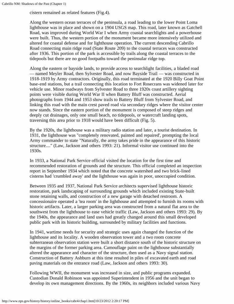
cistern remained as related features (Fig.4).
Along the western ocean terraces of the peninsula, a road leading to the lower Point Lomalighthouse was in place and shown on a 1904 USGS map. This road, later known as GatchellRoad, was improved during World War I when Army coastal searchlights and a powerhousewere built. Thus, the western portion of the monument became more intensively utilized andaltered for coastal defense and for lighthouse operation. The current descending CabrilloRoad connecting main ridge road (State Route 209) to the coastal terraces was constructedafter 1936. This portion of the park is accessible by trails along the coastal terraces to thetidepools but there are no good footpaths toward the peninsular ridge top.
Along the eastern or bayside lands, to provide access to searchlight facilities, a bladed road— named Meyler Road, then Sylvester Road, and now Bayside Trail — was constructed in1918-1919 by Army contractors. Originally, this road terminated at the 1920 Billy Goat Pointbase-end stations, but a trail connecting this location to Fort Rosecrans was widened later forvehicle use. Minor roadways from Sylvester Road to three 1920s coast artillery sightingpoints were visible during World War II when Battery Bluff was constructed. Aerialphotographs from 1944 and 1953 show trails to Battery Bluff from Sylvester Road, andlinking this road with the main crest paved road via secondary ridges where the visitor centernow stands. Since the eastern portion of the monument is composed of steep ridges anddeeply cut drainages, only one small beach, no tidepools, or watercraft landing spots,traversing this area prior to 1918 would have been difficult (Fig. 5).
By the 1920s, the lighthouse was a military radio station and later, a tourist destination. In1931, the lighthouse was "completely renovated, painted and repaired', prompting the localArmy commander to state "Naturally, the army takes pride in the appearance of this historicstructure...." (Law, Jackson and others 1993: 21). Informal visitor use continued into the1930s.
In 1933, a National Park Service official visited the location for the first time andrecommended restoration of grounds and the structure. This official completed an inspectionreport in September 1934 which noted that the concrete watershed and two brick-linedcisterns had 'crumbled away' and the lighthouse was again in poor, unoccupied condition.
Between 1935 and 1937, National Park Service architects supervised lighthouse historicrestoration, park landscaping of surrounding grounds which included existing State-builtstone retaining walls, and construction of a new garage with detached restroom. Aconcessionaire operated a 'tea room' in the lighthouse and attempted to furnish its rooms withhistoric artifacts. Later, a larger parking area was constructed from a natural flat area to thesouthwest from the lighthouse to ease vehicle traffic (Law, Jackson and others 1993: 29). Bythe 1940s, the appearance and land uses had greatly changed around this small developedpublic park with its historic building, surrounded by military facilities and functions.
In 1941, wartime needs for security and strategic uses again changed the function of thelighthouse and its locality. A wooden observation tower and a two room concretesubterranean observation station were built a short distance south of the historic structure onthe margins of the former parking area. Camouflage paint on the lighthouse substantiallyaltered the appearance and character of the structure, then used as a Navy signal station.Construction of Battery Ashburn at this time resulted in piles of excavated earth and roadpaving materials on the entrance road (Law, Jackson and others 1993: 30).
Following WWII, the monument was increased in size, and public programs expanded.Custodian Donald Robinson was appointed Superintendent in 1956 and the unit began todevelop its own management directions. By the 1960s, its neighbors included various Navy

Cabrillo NM: Shadows of the Past (Chapter 1)
http://www.nps.gov/history/history/online_books/cabr4/chap1.htm[10/23/2012 2:20:17 PM]
program facilities and the City of San Diego's sewer treatment plant (Fig. 6). A one-storyvisitor center with administrative offices, auditorium, enclosed viewing and sales area andrestrooms was dedicated in August 1966. By the 1980s, Park Service management plans,environmental analyses studies, an administrative history, historic structure report on thelighthouse, resources management plan, and specific cultural resources studies had beencompleted.
Land uses, when considered as cumulative, include the original ridge crest road route withlate 19th —early 20th century secondary roads to coast artillery emplacements and a coastalterrace lighthouse. By 1920, Gatchell and Meyler roads connected on eastern and westernsides of the peninsula to military installations to the north of the monument area. Foot-trailscan be seen in historic photos connecting some roadways to artillery base-end triangulationstations and to the 1942 Point Loma Battery with its clustered gun emplacements andbunkers. Alignments of security fences are visible on historic military photographs. Exoticvegetation species have been planted since the 1920s.
Thus, sequences of large-scale ridgetop terrain alternations for major coastal batteries,roadways, parking lots and buried utility systems for military and civilian functions haveresulted in discontinuous preserved areas of natural topography — slopes and coastal terraces— covered by native and introduced vegetation. Sparse historical artifactual resources aroundthe lighthouse, at existing coast artillery emplacements of WWI and WWII, and isolatedartifacts such metal or lumber relating to military activities remain today as historicalarcheological resources.
Archeological Materials in Park Collections
Archives, photographs, fine arts, historic objects and furnishings, natural history specimens,and archeological materials compose the monument's curatorial resources (See National ParkService 1999). Prehistoric artifacts are limited to three grinding rock slabs showing concavetrough-like surfaces, worn by horizontal milling activities and five loaf-shaped handstoneswith convex worn surfaces, Regretfully, no provenience (place of origin) information isavailable for most objects. One handstone was found in 1964 near a documented prehistoricsite along Gatchell Road by historian F. Ross Holland and archeologist Dr. Paul Ezell. Onegrinding slab and one handstone are on exhibit at the visitor center museum.
Historical artifacts found during archeological work are more numerous but are limited tobuilding materials such as sun-dried adobe bricks, baked flooring tile fragments andindustrially manufactured fired clay bricks. During the 1991 lighthouse restoration project,one common red brick and one light-colored 'firebrick' were found in earthen fill nearexterior northeast and southeast corners of the structure. The firebrick was stampedEXCELSIOR which indicates a manufacture by Pacific Clay Products of Los Angeles,between 1921 —1942 (Gurke 1987; 232). A reddish-orange brick stamped USMP was foundduring the archeological project at Battery Point Loma in 1984 but has not been identified asto manufacturer. Adobe brick fragments and floor tile fragments in the collection areenigmatic. A few are clearly from the Fort Guijarros area but were collected and placed inthe monument's collections before Fort excavation projects were begun.
One tile fragment is said to have been found during lighthouse tower restoration work in1981. The use of square 'Spanish Tiles' in the lighthouse is strongly suggested by a commentfrom a Lighthouse Board inspector who was told in 1855 that the structure's basement floorwas paved with '...tile from an old Mexican fort nearby'. This reuse of Fort Guijarros tileswas covered over by a concrete floor installed in 1880 (Holland and Law 1981: 116). Thefloor was lowered six inches during the 1930s restoration work, thus removing both theoriginal 'tiles' and the 1880 concrete layer.

Cabrillo NM: Shadows of the Past (Chapter 1)
http://www.nps.gov/history/history/online_books/cabr4/chap1.htm[10/23/2012 2:20:17 PM]
Six examples of adobe bricks were collected from trenching operations in May 1982southeast from the lighthouse. At a depth of 18 inches to 24 inches, about 15 adobe brickswere found with 'chicken wire' and unidentified bird feathers. Informal comparisons weremade between these examples and others known from San Diego "Old Town" buildings andFort Guijarros.
Although there are no paleontological specimens in the collections, fossils of Cephalopod'ammonite' group are known by some researchers to be embedded within the outcroppings ofPoint Loma Formation. With the exception of stone grinding slabs and handstones, no otherNative American archeological or ethnographic artifacts are present in the monumentcollections. There are no materials conforming to the definitions of human remains, sacredobjects, patrimony or funerary objects in the Native American Graves Protection andRepatriation Act.
Previous Archeological Research in the Point Loma Locality
Between 1902 and 1920, three definite archeological resources on the Point Loma Peninsulawere observed and recorded by pioneering University of California archeologists Nels C.Nelson and Howard O. Welty (see Kroeber 1925). One large shell 'midden' mound site (nowlabeled as SDi-48) was observed along the earlier northern shoreline of Ballast Point. Nelsondescribed this 'refuse heap' as 400 feet long, at least 50 ft. wide and 5 ft. thick. Nelson notedthat a battery of 'small guns' had been constructed on the mound as part of Fort Rosecrans'emplacements. Two prehistoric midden sites recorded by Nelson and Welty along theshoreline north of La Playa area were later investigated by Joan Jensen, then Chair of theHistory Department at California Western University, in the 1960s (Morairity 1977: 253-4).
During the 1930s and 1950s, geographer George Carter visited many localities in the SanDiego area, including Point Loma (1957: 272-277). Along the peninsular ridge top whereerosion and roadways revealed open soil, Carter noted scatters of felsite flakes, small hearthsringed with cobbles, small patches of chione, pecten and oyster shells, but only sparseartifacts such as grinding tools, pottery fragments, or arrowpoints. These few culturalmaterials were seen along the ridgetop from military grant boundary southward toward thehistoric lighthouse. Paleontological materials in the form of a fragment of camelopus jawfossil was found in the early 1940s within Fort Rosecrans (Hertlein and Grant 1944: 40). In1962, a flexed burial of Native American human remains was discovered during road gradingin Fort Rosecrans (Moriarity 1977: 255). Some shell fragments, a modified hand stone, andfragments of a large slab grinding stone were found with the remains which appeared to datebetween 5000-6000 years ago. Apparently, the human remains were left in place (seeOverton 1986:208-209).
In 1959, archeologist Claude Warren, then of the University of California at Los Angeles,conducted the first terrain survey of the Monument, at the request of F. Ross Holland, ParkService historian who had been stationed at the park from that year to 1964. Warren's one-day survey in December did not locate archeological resources and the field methodologywas not described.
Discoveries of peninsula off-shore underwater archeological or historical objects includedrecovery of isolated historic objects, building materials and faunal remains as scattered itemsalong Ballast Point, recorded as site SDi-8897 (Pettus 1982). A small sandstone stone bowlmortar and a spherical stone artifact were found in 50 feet of water, due west of Old PointLoma Lighthouse, recorded as site Sdi-8669 (Hudson 1976).
Terrain Assessment Surveys and Excavations

Cabrillo NM: Shadows of the Past (Chapter 1)
http://www.nps.gov/history/history/online_books/cabr4/chap1.htm[10/23/2012 2:20:17 PM]
In early 1975, Park Service temporary archeologist David S. Johnson conducted anarcheological survey of about 50 acres newly added to the eastern side of the monument.Johnson's survey coverage included hiking traverses in a criss-cross pattern over the steepslopes and narrow coastal terraces. This project was completed in less than two days but didnot include observations on military structures or features located in this area. The projectwas described on an Archeological Clearance format, issued by the Service's WesternArcheological Center at Tucson as Clearance O89-CABR on January 29, 1975.
In June 1975, Park Service Archeologist Roger Kelly conducted further terrain clearancesurveys for proposed nature trails, including one using a former military road within easternparcel, as an addendum to Clearance O89-CABR. Twelve debris 'dumps' to be removed werealso visited which were separate, small piles of lumber and solid waste such as concretebuilding materials and metal objects. Further identification of these materials was not made.
At this time, Superintendent Tucker and Park Service Regional Office Historic Preservationstaff proposed preparation of a summary report regarding the monument's historic andprehistoric archeological resources. The services of Dr. James Moriarity, University of SanDiego, were obtained through a purchase order to conduct field work and historical researchduring 1975-76, resulting in the completion of "Cabrillo National Monument; A Physical andCultural Overview" in 1977. His synthesis utilized personal knowledge and professional workover many years in the San Diego area as well as expertise from other leading archeologists,historians, and military experts. Report chapters included specific environmentalcharacteristics of the Peninsula, prehistoric cultural occupation of the San Diego Bay andPoint Loma area, historical land uses and military occupation, and an inventory of physicalcultural and historical resources.
In 1976, Service Historical Architect Kenneth Keane visited the Monument to record historicmilitary structures for the Service's 'List of Classified Structures', a nationwide initiative. Hemade field visits to most structures and produced architectual descriptions with photographs.Near some of the features in the eastern parcel, he photographed lumber and other materialspossibly related to the WWII operations at this location which had been observed in 1975 byKelly and Moriarity.
In 1977, archeological terrain inspection for expansion of the Monument's Maintenancefacility was done, based on Johnson and Moriarity's negative reports.
In 1981, Archeological Clearance Number (072-81-CABR) was issued for ground-disturbingactivities necessary for a Navy Erosion Control project along Gatchell Road, within thewestern portion of the Monument. Potential archeological resources visited and discussed byMoriarity for this area were field-checked by Archeologist Kelly.
Also in 1981, a contractor under Park Service supervision conducted an historic preservationproject at the historic lighthouse. During this work, concrete trough-shaped rain catchmentsinstalled in the late 1930s were revealed during exposure of below-grade exterior surfaces ofthe stone walls. Archeologist Roger Kelly, using information gained from a former ParkService employee who had retired to Trinidad, California, accomplished an investigation andrevealing of these troughs. Since moisture levels in the Lighthouse basement had been aproblem since the 1930s, documentation of these unexpected troughs was necessary.
In early May, 1982, Navy contractors excavating a narrow utilities trench through the westernedge of the Whale Overlook parking area, about 150 feet south of the lighthouse, revealed arow of about 15 adobe bricks at 18 to 24 inches depth below asphalt paving. This singlecourse row was found with a deposit of white beach sand, only visible on one side of themachine-dug trench, and was monitored by Ranger Brett Jones. In addition, unexpected

Cabrillo NM: Shadows of the Past (Chapter 1)
http://www.nps.gov/history/history/online_books/cabr4/chap1.htm[10/23/2012 2:20:17 PM]
finding of pieces of 'chicken wire mesh' and 'chicken feathers' near the bricks make thisdiscovery a mystery. Further, an older buried pipeline was encountered at about the samedepth. While this area south of the lighthouse was the location of a large wooden observationtower and two concrete command bunkers during World War II. Later, in the 1960s, largequantities of fill earth from construction of the City of San Diego's Water Treatment Planconstruction were used to enlarge the parking lot (see Fig 6). The adobe bricks were includedin the park's museum collections.
In 1983, Clearance Number 016-83-CABR was issued for installation of buried utilities byNavy contractors to supply Park Service maintenance facilities.
In 1984, Clearance Number 007-84-CABR was issued for uncovering WWII gunemplacement (Point Loma Battery) for preventative maintenance. This Battery wasconstructed quickly in January 1942 as a four 155mm-gun emplacement, with accompanyinggun crew facilities. In June and August of 1984, Youth Conservation Corps crews exposedmost of one poured concrete circular ring upon which the WWI field cannon werepositioned. After removal of the field guns, the battery rings were filled with local dirt in1968 but natural erosion revealed some of the structure in 1981. Removal of this material didreveal wooden camouflage net frame fragments, burlap pieces, and 1945 Los Angelesnewspaper pieces (see Jones and Overton 1984).
In 1987, Clearance Number 070-CABR was performed to document 'no effect' upon culturalresources by a proposed widening project for Gatchell Road near the City of San DiegoWaste Water facility.
In November 1989, Brian Smith and Associates, an archeological consulting firm, conducteda field survey for the City of San Diego along the Gatchell Road to the Waste Water facility.A 'record search' was done at San Diego Museum of Man and the Information Center at SanDiego State University. An Federal Antiquities Permit was issued for this activity (Smith andAssociates 1989). Several prehistoric midden sites noted by Moriarity were revisited.
In December 1990, Mooney and Associates also performed field survey along the GatchellRoad segment leading to the City Water facility. The following site numbers were assignedto ten historical and prehistoric archeological sites (SDi=San Diego County, number indicatesunique site identification within the County):
SDi 11,930 53x15m disturbed shell scatter, no visible artifactsSDi 11,931 21x9m disturbed shell scatter, no visible artifactsSDi 11,932H 27x16m WWII historic feature (searchlight)SDi 11,933 46x31m disturbed shell scatter, no visible artifactsSDI 11,934 30x25m disturbed shell scatter, no visible artifactsSDi 11,935 75x70m disturbed shell and lithic artifact scatterSDi 11,936H 118x28m WWII Point Loma BatterySDi 11,937 123x54m disturbed shell and lithic artifact scatterSDi 11,938 143x15m disturbed shell and lithic artifact scatterSDi 11,939 42x18m disturbed shell scatter
In 1999, Archeologist Kelly performed a series of test excavations near the lighthouse inattempt to locate physical evidence of historic outbuildings. The activity was in support of thehistoric landscape restoration proposal of the General Management Plan. Ten small hand-dugtest pits were excavated as assumed locations for outbuildings such as assistant lighthousekeepers quarters, privy, and picket fence line. No direct evidence of these structures wasfound but nature of the 1930s landscaping and plant irrigation pipes were encountered, aswas natural bedrock in one unit. Other than 1930s water pipes, no artifacts were found. Any

Cabrillo NM: Shadows of the Past (Chapter 1)
http://www.nps.gov/history/history/online_books/cabr4/chap1.htm[10/23/2012 2:20:17 PM]
artifactural or structural evidence of former outbuildings seems to have been removed duringthe 1930s grade alternation and landscaping.
In 2000, ASM Affiliates, a cultural resources consulting firm, was contracted by the City ofSan Diego to perform site evaluation studies at three archeological resources in or near aproposed curve widening project along Gatchell Road (see Reddy and others, 2000). Updatedsite information sheets for SDi-11,935, 11,936H, and 11,937 were completed by ASMAffiliates who suggested that sites SDi-11,935 and 11,937 were likely not eligible to theNational Register of Historic Places. Site integrity and potential for information wasapparently lacking due to erosion and impacts from Gatchell Road. Site SDi-11,936Hdocumentation was updated with the recommendation of eligibility to the National Registerfor historical archeological resource values.
The California State Historic Preservation Officer concurred with these recommendations onAugust 32, 2000. The Reddy report contains concise summaries of research design approach,field and analytical methods used, and detailed descriptions of three recorded sites, includingthe military structures and features at two locations. Formal "Primary Records" werecompleted for each site investigated and illustrated with photographs and site maps. AFederal Antiquities Permit was issued for this work.
In August 2001, Archeologist Kelly conducted a re-survey of the ca. 50-acre east-side parcelto bring older terrain inspections up to current Park Service standards of site conditionevaluation. Only archeological materials associated with historic military land uses wereobserved. illegal entry into one of the paired Billy Goat Point base end stations (on bothmonument and Navy lands) has resulted in vandalism. In 1993, one structure had beencleaned and secured against entry by the San Diego Urban Corps but the same structure hassuffered vandalism since that project. A second station remains secured against entry. The1942 Battery Bluff was recorded as an historical archeological site as well as an architecturalresource. While two poured concrete gun emplacements are in fair in partially buriedcondition, wooden elements and a frame box structure have deteriorated since firstphotographic documentation in 1976. A few surface artifacts and a dug-out feature are otherarcheological resources. An oral historical account documents the military activities at thislocation during WWII (Overton 1986).
Two 1920 base end stations were also visited by Kelly. Both may be entered through loosesteel shutters. Their condition is good although 1995 graffiti is visible in one building.Fragments of window glass and milled lumber are scattered on slopes near these structures.These discarded materials seem to be post-WWII abandonment. About 150 feet southwestfrom the 'old Maintenance Building', a possible stone quarrying area was observed as anunnatural circular area in a south-facing slope, near the Park Service facility. Its nearness tothe 1850s lighthouse may be coincidental, however. An earlier segment of the former'Humpheys Road' was traced for several hundred feet paralleling the current roadway but at alower contour line. Two poured concrete features were seen as features of this long-abandoned military roadway.
Condition of Archeological Sites
An intensive inventory and assessment of historical and archeological resources on Navy andCoast Guard lands at Point Loma indicated that about 25 prehistoric sites were visible in theearly 1980s for professional documentation (see Rower and Roth 1982: Table 1). In addition,the eight recorded sites listed above within the monument and those prehistoric middendeposits located in recent years beneath modern military developments indicate a minimumnumber of places on the peninsula utilized by native peoples through time (see subsequentChapters in this report). Researchers Rower and Roth noted that moderate to severe erosion

Cabrillo NM: Shadows of the Past (Chapter 1)
http://www.nps.gov/history/history/online_books/cabr4/chap1.htm[10/23/2012 2:20:17 PM]
and construction impacts are characteristics of all sites documented during their inventoryproject. The eight known prehistoric sites within the monument have sustained impacts fromocean exposure, run-off and sheet wash as well as road construction of Gatchell Road andearlier routes. All of these sites are located on ocean-facing slopes and coastal terraces of themonument's western area, indicating past cultural activities along a tide-pool near shore zone.Intensive terrain survey thoughout the monument has not revealed additional prehistoricarcheological resources. Coverage by systematic archeological surveys may be said to cover90% of current monument terrain.
Two sites originally recorded by Brian Smith and Associates (SDi-11,935 and 11,937) wereinvestigated by ASM Associates but were determined as not eligible to the National Registerof Historic Places due to loss of integrity and scientific values. The remaining 6 prehistoricsites are in fair condition, protected somewhat by vegetation. Ground cover and native shrubsshould be encouraged to reduce weathering and pedestrian travel near the fragile sitesurfaces. Two historic architectual and historical archeological sites (SDi-11,936 and 11,932)are of military origin and are in good condition as buried features, which reduces weathering.Site SDi-11,936 (Battery Point Loma) is a contributing property to the Historic District forhistorical archeological values at local and national levels. The Battery Bluff site (notrinomial number) is in fair condition but elements of that emplacement are in poor conditionas noted. All monument archeological resources are included in the Park ServiceArcheological Sites Management Inventory System (ASMIS), a park systemwide automateddatabase which includes 'poor, fair, and good' site condition definitions for prehistoric andhistorical archeological resources.
References
Abbott, Patrick L.1999 The Rise and Fall of San Diego. Sunbelt Publications, San Diego.
Bergen, Frederick W., H.J. Clifford, S.G. Spear (D.M. Burns, editor)1997 Geology of San Diego County: Legacy of the Land Sunbelt Pub., San Diego.
Cabrillo National Monument Foundation1999 An Account of the Voyage of Juan Rodriquez Cabrillo. San Diego.
Carter, George1957 Pleistocene Man in San Diego. John Hopkins Press, Baltimore. MD
Carey and Company2000 Historic Structures Report for Harbor Defense Structures; Cabrillo National Monument.Prepared for the National Park Service. San Francisco
Dana, Richard Henry1959 Two Years Before the Mast. Doubleday, New York
Florence, Hank, Robbyn Jackson and others1993 Cultural Landscape Analysis and Recommendations the General Management Plan,Cabrillo National Monument. National Park Service, San Francisco.
Flower, Douglas and Linda Roth1982 Cultural Resource Inventory: Archaeology/History/Architecture: Navy and Coast GuardLands Point Loma, San Diego California. Prepared for Dept. of Navy, Western Div., NavalFac. Eng. Comd, Naval Ocean Systems Ctr., San Diego
Gurke, Karl
Cabrillo NM: Shadows of the Past (Chapter 1)
http://www.nps.gov/history/history/online_books/cabr4/chap1.htm[10/23/2012 2:20:17 PM]
1981 Bricks and Brickmaking: A Handbook for Historical Archeology. University of IdahoPress, Moscow.
Hertlein, U. S. Grant IV1944 "The Geology of the Marine Pliocene of San Diego, California" San Diego Society ofNatural History. San Diego.
Holland, L. Ross and Henry Law1981 Historic Structure Report: Lighthouse; Cabrillo National Monument. National ParkService
Hudson, Dee Travis1976 Marine Archeology Along the Southern California Coast. San Diego Museum of ManPapers, No. 9. San Diego.
Jones, Brett and Howard Overton1984 Project Report: Battery Point Loma 155mm Gun Emplacement Preservation. CabrilloNational Monument, National Park Service.
Joyce, Barry Alan1995 A Harbor Worth Defending. Cabrillo Historical Association. San Diego.
Keniston Architects1996 Fort Rosecrans: Point Loma Coastal Defenses. National Register of Historic PlacesNomination. Prepared for Naval Command, Control and Ocean Surveillance Center. SanDiego.
Knipper, Carol1996 "Sharing Resources: The Growth of Cabrillo National Monument". Newsletter ofCabrillo National Monument and Cabrillo Historical Association, Vol. IV, No. 8, pp. 12-14.San Diego.
Kroeber, Alfred1925. Handbook of California Indians. American Bureau of American Ethnology, Bulletin78, Smithsonian Institution, Washington, D.C.
Lehmann, Susan Collins1987 An Embarrassment of Riches: The Administrative History of Cabrillo NationalMonument. Cabrillo Historical Association, San Diego
Lockwood, Herbert1964 "The Mormon Mine". The Western Explorer, Vol. II, No. 3, pp. 1-19. CabrilloHistorical Association, San Diego.
Luomala, Katharine1978 "Tipai-Ipai". Handbook of North American Indians: Volume 8 California, pp. 592-609.Smithsonian Institution, Washington, DC.
Klenner, Patricia1983 Robert Decatur Isreal: San Diego Pioneer and Keeper of the Light. Master Thesis,University of San Diego.
Moriarity, James R. III1977 The Cabrillo National Monument: A Physical and Cultural Overview. Prepared forNational Park Service, San Francisco; Purchase Order PX 8000-5-0817. University of San

Cabrillo NM: Shadows of the Past (Chapter 1)
http://www.nps.gov/history/history/online_books/cabr4/chap1.htm[10/23/2012 2:20:17 PM]
Diego.
Michels, WilliamND Old Point Loma Lighthouse Outbuildings. With 1990 "A History of the Old Point LomaLighthouse" by Ashley Thomas McDermott, San Diego State College, History 198.
National Park Service1999 Museum Management Plan, Cabrillo National Monument. San Diego.
Overton, Howard B.1986 Oral History Program: Completed 1986. Cabrillo Historical Association.1993 The 19th Coast Artillery and Fort Rosecrans: Remembrances. National Park Service,Cabrillo National Monument
Pettus, Roy1982 "Underwater Archeology Research in San Diego Bay Offshore from Fort Guijarros" INFort Guijarros, Tenth Annual Cabrillo Festival Historic Seminar (1), pp. 23-60.
Pourade, Richard F.1960 The History of San Diego: Volume 1: The Explorers. San Diego Union-TribunePublishing Company. San Diego.
Reddy, Seetha and others2000 National Register of Historic Places Eligibility Evaluations at CA-SDI-11,935 and CA-SDI-11,937H on Point Loma, San Diego County, California. Prepared by ASM Associatesfor the City of San Diego.
Shipek, Florence1987 Pushed Into Rocks: Southern California Indian Land Tenure 1769 — 1986. Universityof Nebraska Press, Lincoln.
Thompson, Irwin and Howard Overton, eds.1991 Guns of San Diego: San Diego Harbor Defenses, 1796-1947. National Park Service,San Diego.
Urban Corps of San Diego1993 Lower Base End Station at Billy Goat Point: Historic Site Survey, Cabrillo NationalMonument, San Diego.
<<< Previous <<< Contents >>> Next >>>
cabr/shadows/chap1.htmLast Updated: 06-Apr-2005

Cabrillo NM: Shadows of the Past (Chapter 2)
http://www.nps.gov/history/history/online_books/cabr4/chap2.htm[10/23/2012 2:20:28 PM]
CABRILLO
Shadows of the Past
CHAPTER TWO:OVERVIEW OF THE POINT LOMA PENINSULA PREHISTORY
Introduction
This synthesis of relevant published and unpublished literature addresses the potentialscientific value of prehistoric archaeological sites located on Point Loma, California. Thesynthesis includes several broad anthropological research questions that have receivedconsiderable attention already and to which future recovery data from Point Loma sites couldcontribute. By discussing progress to date and future research goals, integration ofinformation recovered from Point Loma sites into these broad questions can demonstratetheir potential eligibility to the National Register of Historic Places. Conversely, ineligibilityto the National Register for certain resources will be discussed as well. Historicalarchaeological resource sites are also judged in a similar way, as noted in following sections.
Laws and Regulations
Use of this overview will have utility in assessing the potential eligibility of historic andprehistoric archaeology sites. Natural erosion, impacts by wild and domestic animals, andman made improvements detract from the matrix integrity. The focus of a land managershould be to assess degrees of integrity loss against the potential of the resource to supportscientific questions and thus meet Criteria D of the National Site Preservation Act of 1966(Title 36 Code of Federal Regulations, Section 60.6). Criteria A of the Act which identifies asite as an example of a significant theme or pattern of history, architecture, archaeology,engineering or culture for a locality, state or nation may also apply.
Two other National Site Preservation Act criterion not likely to apply to prehistoric sites asevaluations are Criteria B which addresses associations with historically prominent personsand Criteria C which requires identification as work of a master, has high engineeringdistinction or possesses high artistic values. Some historical archaeological sites may alsomeet these criteria, however. Site integrity is also important to the automated archaeologicaldatabase for the Park Service called the Archaeological Sites Management Inventory System(ASMIS).
Academic Research Schools
There have been several distinct academic 'schools' of research in San Diego that havefocused on important research questions of their times. For example, early research by theSan Diego Museum of Man attempted to develop cultural sequences that correlated togeologic chronology. Malcolm Rogers published, critiqued, and republished culturalsequences for the earliest to the most recent prehistoric people in Southern California. Rogerslater adopted linguistic models to explain chronological tool and pottery sequence changes. Inthe 1950s and 1960s, the University of California at Los Angeles directed advanced studentsto the San Diego area to study potential environmental change during geological and culturalsequences. Carl Hubbs, Scripps Institute of Oceanography, contributed substantially to
Cabrillo NM: Shadows of the Past (Chapter 2)
http://www.nps.gov/history/history/online_books/cabr4/chap2.htm[10/23/2012 2:20:28 PM]
radioisotope and radiocarbon dating to study seawater temperature and marine specieschanges in those same chronological periods as ancient people occupied the region. SanDiego State University, University of California at Riverside, and private contractarchaeologists attempted to study cultural processes of change in the 1970s. Today, a widevariety of private, museum, and academic archaeologists are synthesizing these pioneeringapproaches to newly formed research questions.
Paleogeography of the San Diego Coast
Transformational effects such as rising sea levels, changing sea temperatures, world-wide seaand weather cycles and changes, and landform modification on populations of organisms areimportant to the understanding of the broader context of prehistory in the San Diego region.These transformational changes affected prehistoric people as they relocated occupation areasin response to changing shorelines and less reliable food sources. Population movementsoften brought groups of people together, where trade, exchange of ideas, marriage, and newpolitical alliances further caused regional change. It is this broad context that provides thelaboratory for scientific archaeological inquiry on Point Loma.
Since the peninsula is an exposed, prominent ridged landform separating San Diego Bay fromthe Pacific Ocean, this land has been steadily eroded by rising sea levels and landslideswhich have severely eroded the coastline over many thousands of years. The shoreline oftoday is not the same observed by the first prehistoric people, who arrived at least 9,000 yearsago. Many of their original camping and occupation sites have fallen into the ocean. Thisdynamic environment is recorded in clues such as artifacts, pollen, marine shell, food bones,diatom, phytolith, and blood residue found on tools in the surviving prehistoric sites.
Archaeological Sites as Time Capsules
In essence, each archaeological site is like a time capsule, composed of materials and artifactsrelevant to the time in which the objects were deposited. As noted, gradual or suddenchanges in sea temperature, rising seawater, and coastal landslides affected creation of thosetime capsules. Orientation of scientific data recovery from Point Loma sites should beplanned to recover evidence relevant to those issues. This orientation needs to incorporatelessons learned from previous researchers with new data to arrive at long-term cumulativesolutions.
For example, since early radiocarbon dates were obtained on San Diego coastal sites, newradioisotope information has become available to indicate certain marine shellfish speciespopulations substantially died-off during fluctuations in marine sea temperatures. Greater orlesser abundance of Chione clams, for example, would reflect such a change. Ifarchaeologists only relied on Chione for radiocarbon dates they might misinterpret theoccupation to fall within the time when the sea water temperature supported large populationsof Chione. However, orienting a scientific investigation to obtain radiocarbon dates onChione, Mytilus, animal bone, charcoal, and charred seeds would greatly improve theaccuracy of dating the actual occupation of the site.
<<< Previous <<< Contents >>> Next >>>
cabr/shadows/chap2.htmLast Updated: 06-Apr-2005

Cabrillo NM: Shadows of the Past (Chapter 3)
http://www.nps.gov/history/history/online_books/cabr4/chap3.htm[10/23/2012 2:20:38 PM]
CABRILLO
Shadows of the Past
CHAPTER THREE:OVERVIEW OF SPANISH AND MEXICAN HISTORY OF SAN DIEGOAND POINT LOMA
Introduction
This summary of historic and archaeological research on Spanish Colonial and MexicanRepublic Period occupation of San Diego will explain the heritage context for Point Lomahistoric sites. The goal is to explain the local importance of historical events and placeswithin the context of Spanish and Mexican government philosophies on exploring, claiming,colonizing, developing community and industry, foreign visitation, and events that led up tothe Mexican War of 1846. Finally, this overview will address the diverse ethnic and gendergroups in the greater San Diego and how they related to the smaller communities of BallastPoint and La Playa, the first non-native settlements of Point Loma (see Fig. 7).
Early Spanish Exploration
Fifty years after Spain conquered the region of today's Republic of Mexico, Spanish militaryexpeditions penetrated the Pacific Coast in search of exploitable resources and routes ofcommercial transit to the East Indies. Under orders from the Viceroy of Mexico, Pedro deAlvarado, armadas were sent north to explore the coast of California and beyond. In 1540,One of Alvarado's officers, Hernando de Alarcon, sailed a Spanish ship up the Gulf ofCalifornia, into the Lower Colorado River and returned to Mexico with tales of a large inlandfreshwater lake, hot deserts, and rich marine resources (Kelsey 1986:83). Two years later,Juan Rodriquez Cabrillo commanded a Spanish expedition and landed to claim UpperCalifornia. Their discoveries led to colonization of 'Alta' and "Baja" California in the 18thcentury.
Cabrillo may have arrived in the New World around 1510 with Panafilo de Narvaez. Heserved in Mexico as a corporal of crossbowmen during battles in Cuba, Valley of Mexico,and Guatemala (Kelsey 1986:9). Confusion exists among some scholars as to Cabrillo's statusas a Portuguese or Spanish citizen, but modern historian Harry Kelsey inferred that Cabrillowas born in Spain from the fact that Narvaez preferred to serve with men of Cuellar, aprovince of Spain (Kelsey 1986:11). It is said that Cabrillo distinguished himself during thebattle for the Aztec capital by waterproofing Cortez' s brigantines with tallow melted fromthe bodies of killed Aztec warriors (Kelsey 1986:33-36), which enabled the Spanish to sailacross Lake Texcoco and conquer the Aztecs in 1521.
Cabrillo rose in the ranks in the service of Pedro de Alvarado during the bloody conquest ofGuatemala. He became a rich and powerful landholder, residing with his large family in thetown of Santiago, Guatemala. Between 1510 and 1536, he signed and recorded his name asJuan Rodriguez. There were many soldiers with the same name serving Spain during thatperiod.
Researchers have found no record of the name Cabrillo prior to 1536 (Kelsey 1986:62), but

Cabrillo NM: Shadows of the Past (Chapter 3)
http://www.nps.gov/history/history/online_books/cabr4/chap3.htm[10/23/2012 2:20:38 PM]
he may have assumed the additional name as a political identity as he rose in power inGuatemala. Under orders from Alvarado, Cabrillo had a fleet of 6 ships constructed inGuatemala to join Alvarado's 1541 Pacific Coast 13 vessel 'armada' for an exploratoryexpedition. Cabrillo himself commanded the galleon San Salvador.
Just prior to setting sail, Alvarado responded to an uprising at Penol de Nochistlan, where hedied (Kelsey 1986:84). Legal complexities caused by Alvarado's premature death placedCabrillo in charge of the armada. The Probate Judge assigned Alvarado's wife as Governorpro tem to administer Santiago in Cabrillo's absence. However, she died a few days later in adevastating Guatemalan earthquake. To recoup Alvarado's investments, Cabrillo buried hispatron's wife and set sail under orders from the Viceroy, Don Antonio de Mendoza. But onlyhis galleon and two other ships composed a smaller convey (Kelsey 1986:99, 113).
Cabrillo's expedition arrived at present day San Diego on September 28, 1542, on the eve ofSaint Michael's feast day, prompting Cabrillo to name the bay 'San Miguel' (Kelsey1986:143). The actual landing probably occurred at beach zone of the bay, rather than onsteep slopes of Point Loma. Later in the voyage, Cabrillo fell on Capitana Island, nowbelieved to be San Miguel Island, broke his leg, and died of untreated gangrene infections onJanuary 3, 1543 (Kelsey 1986:139). His officers returned to New Spain with maps, ships'logs, and other records to be used later by cartographers to plot courses for 'Manila Galleons'crossing the Pacific to Asia.
Spain did not send later expeditions to explore California until Sebastian Vizcaino arrived in1602 (Thompson 1991:3). During the early 17th century, Spain commissioned a number ofmilitary expeditions in search of mythical islands of silver reputed to be somewhere off thePacific Coast. Legends held that a galleon sailing from the Philippines made emergencyrepairs on an island and replaced dirt in the vessel's iron stove box with soil from the island,which later flowed with silver when heated. Many Spanish explorations searched vainly forthe mythological 'Islas de Plata' through the 16th and 17th century. For example, the Spanishexplorer Sebastian Rodrequez Cermano landed today's Drakes Bay in Point Reyes NationalSeashore, Marin County, in 1595. Cermano was enroute to New Spain from Manila withtrade goods but lost his galleon San Agustin during a November storm. Vizcaino also brieflylanded on the shores of the bay marked by cartographers 'San Miguel' which he renamed 'SanDiego' (Horton 1900:16). Newer records were used by Spanish admiralty to chart revisedcourses for 'Manila galleons' which by-passed California coasts north of Point Conception,sailing westward in open waters for the next 150 years.
Spanish Colonization of California
In the 18th century, world politics fueled by news of exploration and discoveries made byother nations concerning the East Indies, South Pacific, and Northwest Pacific alarmed theSpanish Viceroy. Spanish ships were dispatched from San Blas, New Spain in efforts toestablish a military presence in today's British Columbia. Following successful 17th centurycolonization of Baja California by Jesuit Missionaries, the Crown colonized the northern halfof Baja California with Dominican Order missionaries and assigned Franciscan priests toupper or 'Alta California'.
King Carlos III of Spain ordered Jose de Galvez, Visitor General of New Spain, to establishthose California missions and presidios on the Pacific Coast to prevent Russian and Englishoccupation (Thompson 1991:4). The first settlement in today's California was the 1769 colonyat San Diego Bay. Captain Gaspar de Portola led a land expedition late 1769, preceded by agalleon reaching the bay shore in April 1769. Many of the sailors died of scurvy and wereburied on the shore of San Diego Bay, several miles east of Point Loma.
Cabrillo NM: Shadows of the Past (Chapter 3)
http://www.nps.gov/history/history/online_books/cabr4/chap3.htm[10/23/2012 2:20:38 PM]
Captain Portola selected a hill northeast of Point Loma, about five miles from Ballast Pointand San Diego Bay for the first presidio (Black 19 13:47). The first community consisted of130 Spaniards and an unknown number of Native Kumeyaay from the village of Cosoy. TheSpanish ships San Antonio and San Carlos anchored in San Diego Bay, about one mile northof Ballast Point and created an embarcadero on the beach known as La Playa. A trail fromLa Playa to the Royal Presidio de San Diego de Cosoy became one of the first Europeangraded and improved camino in San Diego built by Royal Engineers in 1805 (Black 1913:50).
The Royal Presidio de San Diego de Cosoy changed rapidly over the years from a woodenstockade to a walled town with tall adobe walls, artillery bastions, and merchant centers.Spanish civilians, Native American laborers and traders, and soldiers conducted European-style business within the presidio walls. Once or twice a year, supply ships from San Blas,New Spain, would bring metals, cloth, ceramics, oil and liquor, paint, clothing and munitions.Agricultural products from the mission's fields and gardens provided food commodities forthe small community.. Occasionally, foreign sailing ships visited the bay to obtain freshwater, medical attention, vessel maintenance and for trade.
The Kumeyaay village of Totakamalam on Point Loma is not documented in either Spanishor later Mexican records as being occupied, but Kroeber (1976:Plate 57) reports itsremembered existence. This village may have been located close to the San Diego River, butno archaeological evidence exists. Delphina Cuero, a Kumeyaay from the Jamacha village(25 miles inland) recalls gathering plants on Point Loma (Shipek 1991:27). Cuero noted thatthe Kumeyaay word for Point Loma is Mat kun 'yil 'y' which means black earth in thedistance (how it appeared from miles away). Neither Cabrillo nor Viscaino reported nativesettlements or camps during their early visits. Kumeyaay use of Point Loma during the 18thcentury probably was limited to hunting and gathering expeditions to supply more distantvillages, such as Cosoy.
Conversion of Kumeyaay people really only reached those who were disenfranchised byhigher standing families at Cosoy and other villages around San Diego Bay and up the SanDiego River to the east. A brush ramada chapel built in 1773 on Presidio Hill served bothsoldiers and Kumeyaay converts (Neuerberg 1990). Conflicts between presidio soldiers,Kumeyaay, and Catholic clergy led to relocation from the brush chapel on Presidio Hill to ahill above the Kumeyaay village of nipaguay, six miles east (Black 1913).
In the 1770s, Kumeyaay people began scavenging cloth, broken glass, and ceramic sherdsfrom the refuse pits for trade to their eastern villages and settlements. When cloth scrapswere no longer available, Kumeyaay stole clothing and conflicts broke out with Spanishauthorities (Smith 19 13:48). On August 15, 1774, leading Kumeyaay family leadersretaliated against punishments with an armed insurrection at the mission compound. A priestwas killed and a blacksmith died from injuries. Following a second uprising in 1775, theentire mission compound was burned. The Kumeyaay were resisting the Spanish policy ofencomienda (re-settlement and forced work by native peoples) which caused annihilation ofmany indigenous people elsewhere in New Spain, Central, and South America. In 1778,Spanish architects designed a fortified mission compound and between 1778 to 1813, themission church was replaced or rebuilt due to earthquake damage (Neuerberg 1990).
Spanish Responses to Foreign Incursions
Rumor and fear of Russian exploration in the Northwest in the 1740s alarmed the Spanishcrown, which sent Spanish warships equipped to construct a small cannon battery at Nootkato ward off the foreigners. In 1790, the Spanish artillerists defeated a British warship in aspectacular ship-to-shore battle. The 1790 Treaty of Nootka resulted in a clear dividing line

Cabrillo NM: Shadows of the Past (Chapter 3)
http://www.nps.gov/history/history/online_books/cabr4/chap3.htm[10/23/2012 2:20:38 PM]
between Spanish and British interests. Even though concessions allowed shared authority inthe Northwest Coast, Spain ordered a military build up in the California presidios.
The School of Naval Engineers and the Hydrographic Depot began to scientifically exploreand chart the Northwest from 1754 through 1787 (Higueras 1991:12). To protect the regionfrom Russian, British, French, American, or other interests, the Royal Naval Department ofSan Blas sent ships to patrol the area (Higueras 1991:9-10). To further establish Spain'sclaim, Charles II ordered scientific explorations of Peru and Chile (1777-1787) and CharlesIV ordered additional expeditions to the Philippines, New Spain, Cuba and the NorthwestCoast. The Alessandro Malaspina Expedition of 1789-1794 led to intensification andreorganization of maritime trade with America and the Philippines (Higueras 1991:11).Malaspina and Jose Bustamante y Guerra spent 62 months exploring Buenos Aires,Argentina, Philippines, Mariana Islands, Vavu Archipelago, New Zealand, Australia, andAlaska. They explored the Northwest Coast in 1791. Scientific information collected byGalvez in 1769 and officers at the Presidio de San Diego de Cosoy were continuouslydispatched to San Blas, Mexico and contributed to this research. Packet boats from San Blasbrought news of the expeditions, as well as Asian goods from the 'Manila galleon' trade. Thelatter supply shipments were reduced between 1800 and 1810 due to war in Europe andinternal strife in Mexico, which reduced Spanish supplies throughout California.
The Royal Presidio expanded greatly in the first thirty years. Relocation of Catholic priestsand Mission San Diego five miles east up Mission Valley to the Kumeyaay rancheria ofNipaguay enabled the Spanish Army to assume control of San Diego. The wooden stockadedeteriorated and new plans for adobe walls were initiated in the 1770s. The Regalamentos de1782 issued to the governor of California resulted in a total redesign of the Presidio de SanDiego to expand in size with an exterior vertical wall and two bastions on opposite corners(Thompson 1991). Construction accelerated with the arrival of a well-armed and equippedSpanish Army of Catalonian Volunteers at Monterey, half of which were assigned to SanDiego. Those soldiers set to erecting adobe quarters and completing the walls.
At the same time, Spanish authorities established crystallized control over California with achain of missions and presidios as far north as Sonoma, California. The Viceroy of NewSpain, Conde de Revillagigedo, ordered a policy of defensive possession in California toenforce the articles of the Nootka Convention (Chapman 1921: 515-516). CaliforniaGovernor Jose' Joaquin de Arrillaga carried out that policy in 1792 by ordering studies andselection of sites for military fortifications at the harbors of San Francisco, Monterey, SantaBarbara, and San Diego. Juan Francisco de la Bodega indicated one potential fortification siteon the map of San Diego Bay and surrounding landforms that same year, but the selection ofBallast Point occurred several years later.
The following year, British Captain George Vancouver arrived in San Diego Bay onNovember 27, 1793 on a scientific mission. Spanish authorities treated Vancouver withproper respect, but the dining facilities and quarters did not impress Vancouver, whosubmitted a critical report to English authorities. He reported the presidio to be in a very badstate of repair, but noted the harbor could be considerably strengthened by building a smallfort at the mouth of San Diego Bay.
Spanish Defenses on Point Loma
Spanish authorities had already considered Punta de los Guijarros (Ballast Point) in 1792 forthe location of a 10-gun cannon battery (see Fig. 7). The Spanish frigate Princessa shippedwood from Monterey to San Diego in 1793 for the eventual construction of a barracks andbattery at the Presidio de San Diego (Colston 1982:62). Punta de los Guijarros appears tohave been selected by 1794 based on directions given Miguel Constansó by Governor
Cabrillo NM: Shadows of the Past (Chapter 3)
http://www.nps.gov/history/history/online_books/cabr4/chap3.htm[10/23/2012 2:20:38 PM]
Arrillaga (Ibid.). Following the change of command from Arrillaga to Governor DiegoBorica in that same year, the Spanish government shipped 1410 planks, 50 beams for theesplanade, 6 beams for the barracks, 100 boards and 300 stones to San Diego. A work forceof native Kumeyaay Indians and Catalonian Volunteers drafted from a construction project atthe Royal Presidio were shipped by flat boat five miles south to construct a 10-gun battery atPunta de los Guijarros. During construction, a temporary wickerwork battery filled with sanddefended the bay, which Spanish authorities demolished upon completion of Fort Guijarros in1796.
Although records or pictures do not exist for the Ballast Point fort, plans do exist for abattery at San Francisco which provide important details. At the time Fort Guijarros had beencompleted, a roughly rectangular cannon battery with fourteen cannon ports had beendocumented in an as-built map by Engineer Alberto de Cordoba (Colston 1982:66). Thisdesign showed that the walls were comprised of a 40-foot wide elevated mound with anesplanade elevated 20-feet above the natural ground that ran around the interior. The fronthalf of the esplanade was topped by 8-foot high and 20-foot wide architectural elementsbetween, or merlons, between each gun port. Destroyed by an earthquake in 1815, theoriginal San Francisco battery had been replaced in 1816 by a horseshoe-shaped battery(Bancroft 1884:651).
Analysis of instructions provided by Don Pedro de Lucuze for coastal cannon batteriesconstructed in Campeche, Yucatan, provide further evidence for the appearance of CaliforniaSpanish cannon batteries (May 1995:7). Joaquin Antonio Calderon Quijano published thedesigns of 18th century Spanish engineer Rafael Llobet to defend Campeche from Englishand privateer assaults. The plans of Bateria de San Lucas closely resemble a mark on afederal 1851 Coast Survey map of Ballast Point (May 1995:9). Llobet followed instructionsdetailed in 1772 by Lucuze, but extended the esplanade to 40 feet long. Elevated 28 feetabove the natural ground, Bateria San Lucas protected a barracks about 20 feet behind theinterior of the walls.
The building material available for most Spanish fortification construction in New Spainconsisted of quarried hard stone, such as granite or chalkone. Both the interior and exteriorfaces of Bateria de San Lucas are vertical in the 1792 plans. Lucuze illustrated a hard stonevertical exterior battery face, but both vertical and ramped interior faces (Quillin and Quillin1988:3-7; May 1995:6). Quarry stone is not available in the San Diego region of Californiaand Spanish architects were forced to adapt to marine sandstone, mud and cobble stones onBallast Point. The lowest layer of architecture includes crudely shaped marine sandstoneblocks. A single sandstone block shaped to form a shallow basin to inset in a 30-degreecorner may have been a religious font.
Known today as Fort Guijarros, this cannon battery served as a first line of defense againstpirates, privateers, and smugglers (see Fig.8). The only Spanish and American, ship-to-shorebattle in the history of Spanish California occurred on March 22, 1803 (Colston 1982: seeFig.9). Under orders from the civilian merchant owners of the Lelia Byrd, sailors attempted toconduct illegal trade in sea otter furs with local merchants and were captured by Spanishsoldiers (Bancroft 1886:103). Emboldened by the value of $40 American dollars for eachotter skin, the sailors tried to bribe the soldiers to release a load confiscated a month earlier.An armed force from the ship forced the Spanish soldiers to release the sailors, but the chasewas on. Spanish artillerists fired 9-pound cannon balls and canister shot, while the ship firedsmaller deck and swivel guns at the fort. The Americans also lashed Spanish captives to therailings of the Lelia Byrd in an attempt to discourage the Spanish artillerists from firing onthe ship. Despite the vulnerability of the hostages, the guns of Fort Guijarros fired into therigging and at the waterline to disable the ship. A slack wind virtually stalled ship and a 45-minute exchange of cannon fire between the combatants ensued. With hull and rigging

Cabrillo NM: Shadows of the Past (Chapter 3)
http://www.nps.gov/history/history/online_books/cabr4/chap3.htm[10/23/2012 2:20:38 PM]
damage, the Lelia Byrd escaped San Diego and departed California.
The First Point Loma Light
Two years after the battle of San Diego Bay, Spanish authorities built a small light beacon onthe tip of Ballast Point. Soldiers from Fort Guijarros maintained this light for a number ofyears. The first beacon on Point Loma lasted until about 1810, but lack of maintenancecaused it to crumble into the sand and the pieces scattered by storm wash. By 1820, the lightbeacon disappeared.
Spanish Instability with Foreign Illegal Trade
War in Europe after 1810 and internal economic downswings in New Spain severely reducedsupplies and financing of the California frontier. Soldiers assumed part-time work for pay atMission San Diego. Many soldiers, public servants, and Catholic clergy conducted illegaltrade with visiting American, British, and French ships. The 18th century trade blockadebecame a sham. Smuggling and open illegal trade became more and more common by thetime of the Mexican War of Independence in 1821 (Flower, Ike and Roth 1982). The arrivalof a Mexican Republic governor to San Diego in 1822 put an end to the Spanish Royal inSan Diego. Soldiers either changed uniforms or departed California for Spain. Since most ofthe soldiers were native born, they swore allegiance to the new Mexican Republic.
The Mexican Republic
Mexico opened international trade in 1822 with sweeping changes in world commerce.Licenses issued to foreign businesses resulted in an almost overnight building boom at LaPlaya (Colson 1982). Hundreds of wooden huts and warehouses were erected by companiesand their followers. Several large hide houses were erected to store dried cattle hidesintended for shoe industries in Boston and London. People from all over the world moved toLa Playa and socialized with the California residents. These included Polynesians fromHawaii, Aleut seal and otter hunters from Alaska and the Bering Sea, Black African whalehunters from Portuguese islands of the Azores, New England Native American whalehunters, freed slaves from all over the world, Asian sailors from the Philippines, Maori sealhunters from the South Pacific, and a varied mix of European American immigrants. Thesemariners welcomed shore duty, as described by Richard Henry Dana in Two Years Before TheMast (Dana 1964). La Playa teamed with exotic visitors, most of whom traded in markets atthe Presidio and visited Mission San Diego for Catholic Mass.
Mexican authorities attempted to repair and maintain Fort Guijarros, by then known as LaEsplanada (Flower, Ike and Roth 1982:155: see Fig. 10). The Mexican Army assigned anartillery squad of 22 Mexican soldiers to La Esplanada, whose families lived in quartersbehind the walls. They saw combat in July of 1828, when Captain John Bradshaw of themerchant ship Franklin sailed into San Diego to conduct trade without a license, in defianceof Mexican Law. Ordered arrested for illegal trade, Bradshaw and his crew retreated to hisship and firing cannon shot at the Mexican customs officials at La Playa. Horsemen rode themile south to alert the soldiers at La Esplanada. Artillery batteries returned fire with cannonball, chain and canister shot, injuring Bradshaw. The Franklin limped out of San Diego withhull and rigging damage from 40 cannon shots.
Dana, a sailor working in the leather trade in the 1830s, lived for several months at La Playaand described life ashore. He later returned to America to publish his experiences inCalifornia (Dana 1964). He reported seeing a large brick oven built by Russian scientists in1825 which later housed Hawaiian sailors as apartments. Dana's jobs included washing cattlehides in the shallow bay waters, soaked them in tanning vats, rubbed them with salt andstretched the product to dry. The hide houses were reported to 'stink like death' and jump with

Cabrillo NM: Shadows of the Past (Chapter 3)
http://www.nps.gov/history/history/online_books/cabr4/chap3.htm[10/23/2012 2:20:38 PM]
'millions of fleas and cattle ticks'.
Although Dana did not report seeing Fort Guijarros, it clearly existed as a militia post. Butthe same year Dana arrived at La Playa, Mexico demilitarized California and mustered outthe soldiers. Residents of Ballast Point either moved north to La Playa or Presidio Hill. Theyalso could have joined an exodus of retired military families to a place closer to the SanDiego River and San Diego Bay, which is now called Old Town. Abandoned, Fort Guijarrosdeteriorated quickly. Civilians scavenged the ruins of Fort Guijarros and the presidio for rooftiles, wall tiles, lumber, metal, and adobe blocks for building new homes in Old Town.Commandant Francisco Ruiz sold official salvage rights to retired soldier Juan Machado onJune 17, 1840 (Thompson 1991: 12).
There is no record of what Machado removed from Ballast Point, but Mexican militiacontinued to fire salutes to incoming merchant ships as late as 1843, as recorded in a 1843sketch by G.M. Waseurtz af Sandels (Sandels 1945). A French Legate reported crumblingwalls and six to eight cannon buried in the sand 1842 (Flower, Ike and Roth 1982).
The Mexican War of 1846
Word of economic and political change spread with arrival of each merchant ship,newspaper, or visitor in the late 1830s in California. The Pico and Alvarado families feudedopenly for control of Los Angeles which flowed back and forth between the families. Sailorsfrom the whale ship Stonington stormed the silent ruins of Fort Guijarros in 1843 to hammerspikes in the cannon breeches to prevent their use in fighting rumored U.S. military forcesoffshore (Roth 1982:157).
Congressional fears of British plans for Mexico triggered American covert militarymovements to foment internal revolution in California in 1845 (Bancroft 1886). MarineLieutenant Archibald Gillespie arrived in San Francisco in the guise of a sick civilian andtraveled north toward the Oregon Trail to meet Army Topographic Engineers. There, hesecured a rag-tag militia of mountain men led by John C. Fremont to move south to fightMexican forces in California.
At Monterey, Navy Commodore Sloat awarded a brevet rank of Major to Fremont whoformed the California Mounted Rifles to fight Mexican authorities in Sonoma and LosAngeles. Major Fremont briefly joined the Bear Flag Revolt in Sonoma and then turned southto Los Angeles. Meanwhile, the American Army arrived in Southern California under thecommand of brevet General Stephen Watts Kearney and marched across the PeninsularMountains toward Mexican forces staging at San Pasqual.
The Battle of San Pasqual is undoubtedly the worst military defeat suffered by the AmericanArmy in California. Poor discipline, rain-soaked rifles, and road weary soldiers led to anunplanned cavalry ordered by Army officers, unfortunately into the waiting Mexican Armypositioned in a narrow canyon. Mexican leader Andres Pico wheeled a secondary force ofpiked cavalry out a canyon to spring a classic military trap. By then several Army officerswere dead and others dying from pike slashes, sword stabs and shot. Pico also captured theonly piece of field artillery to arrive on the scene. Most of Kearney' s soldiers were a mile tothe east unaware of the defeat.
Kearney retreated to a defensible position and soldiers skirmished throughout the rest of theengagement. Eventually, Pico pulled back to regroup and General Kearney ordered hissupplies burned to prevent them from falling into enemy hands. Pico elected to withdrawseveral miles away to Francisco Maria Alvarado's adobe to treat the wounded and thendeparted for Los Angeles. Meanwhile, Navy and volunteer forces arrived to rescue Kearney

Cabrillo NM: Shadows of the Past (Chapter 3)
http://www.nps.gov/history/history/online_books/cabr4/chap3.htm[10/23/2012 2:20:38 PM]
and escort them to San Diego. Later accounts by American Army officers confused the orderof battle in an attempt to cover up the failure.
American forces could not immediately relieve General Kearney because they too sufferedheavy resistance from Mexican militia along the shore of San Diego Bay (May 1985a). Atleast 16 Marines died on those beaches and were buried out on North Island. Mexicansharpshooters picked them off as they landed skiffs on the beach. Mexican soldiers alsoremoved a cannon from Fort Guijarros and hitched it to a long rope. They could fire thecannon at the Marines on board the U.S.S. Cyanne or merchant Stonington and then draw thecannon back out of range of the muskets firing from the ships.
Once the Mexican forces withdrew to join Pico at San Pasqual, Marines secured two cannonsfrom Fort Guijarros and marched to capture Old Town to establish an occupation force. Thisentire siege took several weeks. Similar to the propaganda reports generated at San Pasqual.California schoolbooks do not correctly describe the success of Mexican troops to pin downAmerican forces in San Diego during the Mexican War.
Confusion reigned during the late 1840s in San Diego. British and French merchants dealtwith the Army Quartermaster for renewed permits to operate at La Playa. Civilians returningto San Diego had to realign their thinking or become arrested under Martial Law. After theAmerican Army defeated the Mexican militia at the Battle of San Gabriel in Los Angeles,American forces continued to fight in Texas and Mexico. California came under Armycontrol while new State of California and federal Government settled on a CaliforniaConstitution, creating counties and major cites. Ultimately, with ratification of the 1852Treaty of Guadalupe Hidalgo, the Mexican War came to an end.
The Ethnic and Gender Mix
The civilian population of San Diego is documented in 1774 as thousands of Kumeyaay insurrounding villages and the 750 European Americans at the Presidio. By 1846, no more than150 European or Mexican born persons lived at San Diego (Heizer 1978:121). Ethnicconsciousness among Spaniards during that time period does not directly correlate to 21stcentury American concepts. Many of the Spanish soldiers were themselves descended fromMoors, native populations in New Spain and some Asians and Africans. Asian sailors andservants arrived on the 'Manila galleon' to trade blend into Spanish society throughout theentire period of trade between the Philippines and New Spain. These small and relativelyisolated Spanish military communities placed greater value on descent from Spanish-bornancestors than on physical traits.
Shortly after arrival in 1769, Spanish soldiers and artisans married native Kumeyaay womento establish households with them. Converted Kumeyaay lived at the missions but eventuallychose between ancestral families or living near Spanish settlements. Disenfranchised fromtheir coastal villages and prevented from seasonal group movements to harvest shellfish andhunt marine mammals, native non-Catholic Kumeyaay withdrew further east to the LagunaMountains or into Baja California to maintain their native lifeways. Statistical records takenfrom Catholic Mission Baptismal and Death Books demonstrate a massive death rate ofKumeyaay and their native neighbors between 1769 and 1834 (Heizer 1978:121-125).Inadequate healthful diet, diseases, and injuries contributed to the increasing death rate thatreduced practice of Kumeyaay religious faith and opened channels for conversions.
Most of the people who converted to Catholicism in those early days were on the lower sideof the Kumeyaay social and political structure thus had more to gain by joining with theSpanish authorities. Spanish authorities and artisans and families living in the Presidio de SanDiego probably did not recognize the native cultural distinction between nobility and

Cabrillo NM: Shadows of the Past (Chapter 3)
http://www.nps.gov/history/history/online_books/cabr4/chap3.htm[10/23/2012 2:20:38 PM]
commoners. This total lack of understanding or acceptance of the Kumeyaay culture orsociety ultimately led to the 1774 and 1775 uprisings and murder of a priest. Spaniards heldstrong ethnocentric belief that Spain had the only relevant culture, religion and society.
In effect, Spanish Colonial life offered some Kumeyaay an opportunity to rise in social statusthat did not exist in Kumeyaay society. Further, since many Spanish military werethemselves of mixed ethnic descent, a perception of inevitable change to Spanish lifestyleand Catholicism pervaded their thinking. Spanish colonists continued a 200-year-oldtradition of tribute, conscripted labor and relocation aspects of the encomienda when theyarrived to colonize San Diego. This process reduced the native American identity throughconversion to Catholicism, forced relocation in Spanish towns, mandatory hygiene andclothing changes and conversion to dependence on Spanish economics (Heizer 1978:130-135). In fact, some Catholic clergy even debated if native people even had souls. Thisprogram did convert several hundred Kumeyaay, but thousands died from European diseases.The Mission San Diego Baptismal and Death records indicate approximately 4,000 nativepeople were buried in the mission cemetery between the 1770s to 1840s.
Few Spaniards of 18th century California were born in Spain. Many of them were 4th or 5thgeneration citizens of New Spain and themselves descended from native people. Colonistslong held the practice of marrying native people as new communities were established. Acomplicated ethnic reckoning system existed at the time Spain colonized San Diego. Sr. DonPedro Alonso O'Crouley published A Description of The Kingdom of New Spain in 1774,which clearly describes those distinctions (Galvin 1972:19). He defined a child of a Spaniardand a native as a Mestizo, a Spaniard and a Mestizo as a Castizo, a Spaniard and a Castizo asa Spaniard, a Spaniard and an African as a Mulatto, a Spaniard and a Mulatto as a Morisco, aSpaniard and a Morisco as a Albino a Spaniard and an Albino as a Tornatras, a Spaniard anda Tornatras as a Tente en el aire, a native and a Chinese (Chino) as a Albarazado, a nativeand an African as a Sambia go, a native and a Mulato as a Lobo, a native and a Lobo as aCambujo, a native and a Mestizo as a Coyote, and a native and a coyote as a native. Peopleliving at the Presidio de San Diego or in out posts like Fort Guijarros did not think ofthemselves as Kumeyaay Spaniards or African Spaniards, but used the terms O'Crouley listedin relation to how far back a person was descended from a European Spanish family. Thecloser a person could claim to be descended to a European Spaniard, the higher their naturalsocial status.
In the complicated social and class system of New Spain, soldiers and their families of SanDiego could elevate above ethnic classes by rising in military rank. Good service and highachievement meant more pay and promotions in rank. Elevation to an officer of any rankguaranteed high standing and unlimited economic possibilities. Retired soldiers often woretheir uniforms to formal events or in public to mark that social status. In this system, distantethnic claims to European Spaniards could be balanced by these rank elevations. EuropeanSpanish officers always commanded the highest social standing in Spanish California, nomatter what their economic status. Such was the social status of the Spanish-born CatalonianVolunteers, who arrived in California in the 1790s (Colston 1982). The CatalonianVolunteers supervised much of the renovation of the Royal Presidios in Monterey and SanDiego, including work on Fort Guijarros.
Other ethnic groups also existed in 18th and early 19th Spanish society in New Spain. Asiansailors and servants arrived from the Philippines on the Manila galleons as early as the 16thcentury. African slaves and servants arrived with the soldiers of Spain during the conquest ofAztec and other native states of Guatemala, Peru and other places (Galvin 1972). In fact,numerous communities of escaped African slaves developed in the mountains of SpanishMexico during the 16th century, only to integrate into cities and towns in the 17th and 18thcenturies. Intermarriage and ethnic assimilation resulted in very different people who arrived
Cabrillo NM: Shadows of the Past (Chapter 3)
http://www.nps.gov/history/history/online_books/cabr4/chap3.htm[10/23/2012 2:20:38 PM]
to colonize California.
The Spanish Census of 1790 described the Andres and Pio Pico's grandmother as 'mulata'(Carlton 1975:11). Pio Pico later became Governor of California during the Mexican Warperiod. Significant to this discussion, Andres Pico served as Delegate to the CaliforniaConstitutional Convention in 1849 and is not recorded as objecting to the anti-Africanprovisions in the Constitution. The Pico family and others of mixed ethnicity held publicoffice for decades without the kind of prejudice found among Anglo-Americans of the time.
There is no record of ethnic Chinos or Albarazados in San Diego during the Spanish orMexican period. The earliest documented record of Chinese in California is associated withlabor moving in the Gold Rush camps in the 1850s (McPhail 1977:8). The earliestdocumented Chinese in San Diego were recorded living in three houses at a fishing camp onBallast Point in 1863, but none are recorded for the Mexican era (May 1998).
Other than the Pico grandmother, absent are accounts of Mexican Period African Californios.Joseph Cross and Miguel Assisisera are listed in the 1860 national Census as South AmericanAfricans who might have lived in Mexican San Diego (Carlton 1975:11). They may also havearrived from South America to work in the local gold mines in the 1850s. Rare accounts ofMexican Africans exist for Spanish or Mexican California. Spanish Californios simplyaccepted Spanish-speaking Africans as Californios. One of the few accounts of such a groupis documented by the 1852 Grand Jury of San Diego Grand Jury investigating reports of alawless group of Africans, who may have come from Mexico (Carlton 1975:10). At least twoAfrican Americans lived in Mexican California prior to 1847, but they were perceived locallyas Americans.
American military and civilian occupation and immigration to San Diego following theMexican War also resulted in philosophical conflict with the Mexican Californios whooccupied Old Town in 1846. Descended from generations of Spanish and Native populations,these Californios had little identity with Spain. These Californios were as alien in belief andculture to the Americans as the Kumeyaay had been to the early Spanish. One commonalityshared by some of the European Americans was membership in the Catholic Church. Anotherwas the use of American currency in business transactions. The Californios continued toexpand their cattle trade with American merchants and the Army through the Mexican Warand into the following decades. The social bonds from church and economics smoothedtransition from Mexican to American California.
By 1850, the urban population of San Diego is recorded in the national Census as 650 (Garcia1975:55). Many of these people found new jobs with the Army and the rising number ofshops and stores. Many of the Californios were land rich but money poor and lost both tohorse racing and extravagant living. The new immigration of Americans of English descentswiftly overwhelmed the Californios. By 1860, the new immigrants were a majority andthousands of Americans introduced new architectural, clothing, and fashion styles. Englishreplaced Spanish as the primary language and the cattle industry declined with severereduction in the hide industry. The final blow to the Californio identity occurred withintermarriage to Americans of English and other European descents.
References
Bancroft, Hubert Howe1886 History of California. San Francisco: A.L. Bancroft & Company.
Carlton, Robert L.1975 Blacks in San Diego County. Journal of San Diego History, 21 (Fall): 7-20.

Cabrillo NM: Shadows of the Past (Chapter 3)
http://www.nps.gov/history/history/online_books/cabr4/chap3.htm[10/23/2012 2:20:38 PM]
Chapman, Charles E.1921 The History of California: The Spanish Period. New York: The Macmillan Company.
Colston, Stephen A.1982 San Joaquin: A Preliminary Historical Study of the Fortification at San Diego s Puntade Guijarros. In Fort Guijarros. Tenth Annual Cabrillo Festival Historic Seminar, (1):10:61-83. Cabrillo Historical Association, San Diego.
Cook, Warren L.1973 Flood Tide of Empire: Spain in the Pacific Northwest, 1593-1819. New Haven andLondon. Yale University Press.
Dana, Richard Henry1869 Two Years Before The Mast; Twenty-four Years After. London, Dent Everyman'sLibrary, 1972 Edition.
Galvin, Sean (ed.)1972 A Description of The Kingdom of New Spain by Sr. Don Pedro Alonso O'Crouley, 1774.Dublin, Ireland: John Howell Books.
Garcia, Mario T.1975 Merchants and Dons, San Diego's Attempt at Modernization, 1850-1860. Journal of SanDiego History, 21 (Winter): 52-80.
Heizer, Robert1978 Impact of Colonization on the Native California Societies, Journal of San DiegoHistory, 24 (Winter): 121-144.May, Ronald V.1982 The Search for Fort Guijarros: An Archaeological Test of a Legendary 18th CenturySpanish Fort in San Diego. In Fort Guijarros, Tenth Annual Cabrillo Festival HistoricSeminar (1) 10:1-22. San Diego, Cabrillo Historical Association. San Diego.
1995 Evidence for the Physical Appearance of 18th Century Spanish Cannon Batteries inCalifornia. Fort Guijarros Journal. (1) 1:4-15.
1998 Ethnic and Economic Investigation of the Ballast Point Whaling Station and its ChineseComponent (CA-SDI-12953), San Diego, California. Paper presented to the Society forCalifornia Archaeology Annual Meeting, San Diego, California.
McPhail, Elizabeth1977 Chinese Mission. Journal of San Diego History, 23 (Spring): 8-21.
Quillin, Col. Frank (ret.) And Margaret Quillin1988 A Translation of Chapter VI of Don Pedro De Lucuze s 1772 Principios deFortificacíon as it Relates to the Design of the Fort at Punta de Guijarros, San Diego,California. Fort Guijarros Quarterly, (2) 1:3-7.
Robinson, Willard B.1977 American Forts, Form and Foundation. Urbana: University of Illinois Press.
Sandels, G.M. Waseurtz af1945 A Sojourn in California by the King's Orphan: The Travels and Sketches of G.M.Waseurtz af Sandels, A Swedish Gentleman Who Visited California in 1842-1843. SanFrancisco: Grabhorn Press.

Cabrillo NM: Shadows of the Past (Chapter 3)
http://www.nps.gov/history/history/online_books/cabr4/chap3.htm[10/23/2012 2:20:38 PM]
<<< Previous <<< Contents >>> Next >>>
cabr/shadows/chap3.htmLast Updated: 06-Apr-2005

Cabrillo NM: Shadows of the Past (Chapter 4)
http://www.nps.gov/history/history/online_books/cabr4/chap4.htm[10/23/2012 2:20:49 PM]
CABRILLO
Shadows of the Past
CHAPTER FOUR:OVERVIEW OF THE MULTI-ETHNIC BALLAST POINT COMMUNITY ONPOINT LOMA BETWEEN 1846 AND 1900
Introduction
Twenty years after the Mexican War of 1846, whaling companies bound on schooners andships from San Francisco to Baja California stopped in San Diego for food and water (seeFig. 11). Some of those vessels visited San Diego in the 1830s and 1840s, observingCalifornia Gray Whales in the harbor and out on the offshore kelp beds. Although based inSan Francisco, most of the mariners on those ships hailed from maritime centers in NewEngland and the South Pacific. Multi-ethnic crews on those vessels comprised the whalingcompanies. Bonded by kinship and mariner camaraderie, those men carried on a 400-year oldtradition of building houses, kitchens, warehouses, oil-rendering or 'tryworks' ovens, boathouses, carpentry, and blacksmith shops to carry out a seven-month season's work.
Unlike the ethnically segregated communities of Old Town and New San Diego, the BallastPoint Whaling Station of the 1860s and 1870s was distinctively multiethnic with darkcomplexioned Portuguese-Americans, Chinese, Irish-Americans, and European-Americansailors and their families. At least one Native American woman from Santo Tomas, BajaCalifornia, lived in this community. Three Chinese individuals worked for the whalers andsold fish in Old Town and New San Diego. This unique community bought supplies and soldgallons of oil in Old Town and New San Diego, but kept their business affairs to themselves.They lasted for twenty years, and then simply melted into the maritime neighborhoods of LaPlaya and North Island, or slipped away unnoticed to Baja California. The people of theBallast Point Whaling Station are important because their maritime history enabled an earlymulti-ethnic group to work together in an otherwise segregated and racially biased andintolerant Victorian California.
The primary residential communities on Point Loma between the Mexican War of 1846 and1900 were located at Ballast Point and La Playa on the bay side of Point Loma. Ballast Pointis a small cobblestone spit that extends east of Point Loma into the mouth of San Diego Bay.Extreme high tides and storm waves often covered most of Ballast Point, except for a slightlyelevated rise at the eastern tip that formed an island during high tides. A Chinese fishingcamp and American merchant whaling community resided at that eastern island, which wasconnected to Point Loma by a narrower spit of cobblestones and sand at a slightly lowerelevation. Several whalers' shanties and a blacksmith shop were built on top of the crumbledruins of the 18th to 19th century Spanish and Mexican Army cannon battery, Fort Guijarros(see Fig. 8 and 10).
One mile to the north, a half-mile wide point of land projected one-eighth of a mile into thebay to form La Playa. At this location, the Spanish built an 'embarcadero' or landing formerchant ships and later, the Republic of Mexico constructed an adobe customs house. Underlicense with Mexico, British hide industry firms built wooden cowhide warehouses andRussian scientists built a brick oven. A shantytown of scrap and driftwood homes,
Cabrillo NM: Shadows of the Past (Chapter 4)
http://www.nps.gov/history/history/online_books/cabr4/chap4.htm[10/23/2012 2:20:49 PM]
boathouses, craft shops, and auxiliary buildings surrounded the old Spanish embarcadero andMexican customs house. Through the 1870s, La Playa became a diverse community of mixedethnicity. Chinese fishermen and boat builders arrived in the 1880s, to be replaced byPortuguese and Italian fisher folk in the 1890s. By 1900, most of people at Ballast Point andLa Playa vacated Point Loma to live across San Diego Bay in New Town.
Economic and Ethnic Diversity
The first permanent community recorded for Ballast Point following the Mexican War was aloose confederation of American merchant whaling companies residing there during the1857-1858 winter season. These squatters simply moved in and built the community onBallast Point (May 1986:73). Each family-owned company involved comingled investmentsof funds and equipment. Whaling crews recruited from San Francisco may have includedethnic African and Chinese, who served on South Pacific whale ships in the 1840s and endedup in California during the Gold Rush (Nichols 1983:75; Henderson 1975:51; May 1986). Atleast one of the whaling companies on Ballast Point included Portuguese-American whalersfrom New England. These ethnically diverse mariners moved north to La Playa in 1873 andthen across the bay to North Island and New Town in the 1880s.
Research on the economic status and ethnic diversity of the mariners at the 19th centuryBallast Point Whaling Station began in 1981 with the discovery of an historic kitchen middencovering the ruins of Fort Guijarros (May 1982). An 1896 Map produced by the Army Corpsof Engineers showed a rectangular building located on top of the old Spanish fort. Thebuilding was identified as the Blacksmith Shop, adjacent to a square marked Whaler's Shanty(Ibid.). Historical evidence placed the Packard and Johnson Companies on Ballast Pointthrough the 1 860s, along with smaller outfits owned by Levi Tilton, Dan Flanders, William(Billy) Price, and Thomas J. Higgins (May 1986:73-91). A local San Diego citizenrecollected that...
I have always thought a wonderful story could be made of it . . . The whalerswere all New Bedford men and came from West Tisbury, Cape Cod. There weretwo companies. Two brothers Packard and others named Johnson, on BallastPoint. The Packards had a little shack about the middle of Ballast Point and livedin it; but the Johnsons had a much larger establishment, a big building on theshore near Fort Rosecrans. This was used as dormitories for the whalers(Davidson 1930:10).
Within the context of a global whale fishery which began in the late 16th century andcontinues today on a limited scale, the 28-year industry on Ballast Point in San Diego,California is a good example of the continuity of pre-mechanized maritime traditions whichlasted for more than four centuries. Ballast Point is more significant as the sole knownexample of a well-documented shore whaling station in the United States (May 1987;1988:2).
The social history of the families and their community on Ballast Point can be used as amodel of similar industries known as early as the 17th century in New England and as late asthe 20th century at Monterey, California. The unique aspect of Ballast Point lies in thesurvival of architectural features and archaeological deposits that have either been destroyedelsewhere in maritime sites or not yet discovered or reported in the archaeological record(May 1987).
Ballast Point has survived the ravages of modern construction only because of the uniquehistory of the Point Loma Military Reservation as originally 'pueblo lands' of the City of SanDiego. As the site of a former Spanish and Mexican artillery battery, Ballast Point and the
Cabrillo NM: Shadows of the Past (Chapter 4)
http://www.nps.gov/history/history/online_books/cabr4/chap4.htm[10/23/2012 2:20:49 PM]
ruins formed a natural landing and base of operations for visiting sailors following theMexican War in 1846. After the Army Corps of Engineers evicted the whaling companies in1873 to begin military construction, earth fill eventually covered the Spanish barracks andkitchen.
The top of the artillery battery was leveled to ensure a clear field of fire for the Americanbatteries. When Congress cut the funding in 1874, the whaling companies moved back tooccupy Ballast Point and reuse the old tryworks ovens to render oil from California GrayWhales. By 1886, the whale herds were nearly extinct from over fishing. When the LightHouse Service arrived in 1890 to construct the Ballast Point Light House, the former whalingcompany buildings were vacant. The Army returned in 1898 and reused the old whalingcompany buildings for housing and storage until the area was eventually covered with soil inthe 1930s.
By the time author Winifred Davidson wrote the 'Loma Lore' column for the San DiegoUnion in 1930, all that remained were the remnants of two old trywork foundations andblacked, grease-saturated soil. That same year, Assistant Light House Keeper Radford Frankehauled-in tons of yellow sand from road construction on Point Loma to cover the whalers'debris (Franke, Personal Communication).
Historical Record
The written record of the Ballast Point Whaling industry has been traced to 1857, whenbrothers Prince William and Alphaeus Packard arrived in San Diego (May 1986:75). Thetwins were born in Massachusetts in 1815 to a Portuguese father and English mother. Norecord is known of the brother's prior 42 years (Wentworth n.d.; Scammon 1874:23). The1860 Census of Industry recorded that they had $3,000 worth of equipment and a crew of tenmen. Alphaeus and his Native American (Baja California) wife, Magdalena, lived on BallastPoint. The smaller companies, such as those operated by Tilton or Price, joined forces witheach other between October and May during the peak whale runs. From season to season, thecomposition of this community changed. Almost no record exists of the names, ethnicity, oreconomic status of the whaling company crewmembers.
When the Packard brothers arrived at Ballast Point in 1857, it was vacant and La Playa was aghost town (Dana 1964; Davis 1969:16-17; Smythe 1907:103, 202). The hide housesdescribed by Richard Henry Dana in Two Years Before The Mast were in ruin and theMexican Custom House and Army Quartermaster warehouse lay abandoned (Ruhlen1967:10). The Blecker General Store sat out over the shallow water on stilts, near the TidalGage (Smythe 1907:2). Mired in the shallows of mud, the dismantled wreck of the ClarissaAndrews served San Diego as a coal depot (Ibid.). Captain J.C. Bogardt operated an office forthe Pacific Mail Steamship Line in a cabin on the wreck.
It was at the tumbled ruins of La Playa that the Packards met George P. Tebbets, who onFebruary 16, 1856 killed a Right Whale off San Luis Rey and tried-out 600 barrels for tradein San Diego (San Diego Union, February 16, 1856). Tebbets encouraged the Packards todevelop an operation on Point Loma. To be closer to the kelp beds off the western shore, thePackards moved one mile south to Ballast Point to establish their whale blubber-meltingtryworks oven on the beach. There they built boat yards, warehouses, a carpentry shop, atleast one blacksmith shop, a kitchen, and driftwood shanties for their families. By February5, 1858, the Packard Whaling Company had killed twelve and recovered five California GrayWhales for a harvest of 150 barrels of oil worth $2,000 (San Diego Herald, February 5,1858).
Soon the Packards were joined by other whaling families. Captain Miles A. Johnson and his

Cabrillo NM: Shadows of the Past (Chapter 4)
http://www.nps.gov/history/history/online_books/cabr4/chap4.htm[10/23/2012 2:20:49 PM]
cousin, Henry James, hailed from the traditional whaling town of New Bedford,Massachusetts. Another cousin, James Johnson, came from New York (Wentworth m.d.) TheJohnson family operated whaling stations at Cape Colonet and San Martin Island in BajaCalifornia. They also brought five employees and $3,000 worth of materials. Henry JamesJohnson lived on Ballast Point with his common-law wife, Saturinia Carravaya, and theirchildren John, Sara, and Filbury. Captain Miles A. Johnson was a former sea captain andleader of the Johnson Company. These family operations enabled co-investment of moneyand equipment, which made these mobile operations quite workable.
Research into tax and voter records revealed that approximately thirty men lived and workedat the Ballast Point Whaling Station with the Johnson and Packard Companies. While allworked at one time or another as hands on the primary companies, Daniel Flanders, JohnJenkins, Thomas Lambert, William C. Price, Levi Tilton, and Enos Wall operated their ownventures. With the exception of Price, who was born in Ireland, all the others came from NewEngland. Lambert and the Packards were Portuguese descent.
Judge Benjamin Hayes visited La Playa and Ballast Point on January 20, 1861, whiletraveling with friends to the Point Loma Lighthouse (Hayes 1929:557). Hayes reported bothshore and ship whaling on that particular day. Captain W.W. Clark's whaleship, Ocean,operated just offshore:
The ship's men cut up the whale from a staging alongside, of which they standwith their spades--- the fish being afloat. In which there is a great saving of timeand labor, as compared with the process of those on land, who bring the fishashore at the flood; cut, turn it over. And there it remains, an annoyance to them,until some tide may happen to carry it off to another point. I must confess thesmell on shore. . . was anything but pleasant (Hayes 1929:557).
Hayes also described the Packard Whaling Company operation. They reported havingrecovered 450 barrels with a projected yield of 1300 (Ibid). The previous year, in 1860, theyproduced 900 barrels. Each barrel contained 31 and 1/2 gallons of oil. The 1860 Products ofIndustry Census also listed the Johnson Whaling Company and Tilton Company.
The beach operations and layout at Ballast Point remain a mystery, only partially solved byarchaeological investigations (May 1986; 1987). An article in the 1986 Journal of San DiegoHistory drew from analogies from New Zealand and Australia (May 1986). Other knownstations include elaborate communities in Red Bay, New Foundland in the 16th century andthe Northwest Coast in the 19th century. The Portuguese-American whaling stations atMonterey and Carmel were small communities of whitewashed cabins adjacent to gardenpatches of corn and pumpkins, where the families kept pigs, sheep, goats, and cattle incorrals (Scammon 1874:250). Presumably, the residential areas on Ballast Point were similar.Typical of Portuguese whaling operations, the smelly tryworks and warehouses weresomewhat distant from the homes, though small overnight shanties were often locatedadjacent to the tryworks (Clarke 1954:325, 338).
Of the 23 known whalers who operated on Ballast Point between 1858 and 1886, ten camefrom New England, two from New York, one from Ireland. The rest did not register theirbirthplace (Great Register of Voters 1877; Wentworth n.d.). Hammett and Martin Comachocould have been Portuguese, but their birthplace is not known. Their names leave no clue asto the other whaler's ethnic origins. Indeed, names are not positive indicators of ethnicity.
Interestingly, John Jenkins (Pennsylvania), William C. Price (Ireland), and Enos A. Wall(Maine) all worked as assistant lighthouse keepers on Point Loma. Additionally, the 1863 TaxCollector reported a Chinese family in 1863 and Lucy Wentworth documented Juk and Ah
Cabrillo NM: Shadows of the Past (Chapter 4)
http://www.nps.gov/history/history/online_books/cabr4/chap4.htm[10/23/2012 2:20:49 PM]
Sing as fishing on Ballast Point in 1868 (May 1986). The 1870 Census lists Ah Low as theChinese cook for the Packard Company.
Although no records have been found for these operations, legal records of lawsuitsdocument something of the property. District Court Case #108, May 29, 1865, memorializedthe Packard Whaling Company's failure to pay a $743.22 meat bill. The case lists 43 casks ofoil, worth $12,470.00 in San Francisco, as seized by Sheriff James McCoy (May 1986;Robotti 1962:84). Other property included the whaling sloop, New Hope, whale boats,harpoons, tubs of rope, empty barrels, and cases of food (Wentworth n.d.: 3; Hensley 1952;610). McCoy seized the following:
Three bomb lances, one swivel gun in a box, eight harpoons, one tub of towline,one coil of cable rope, one coil of towline, three coil secondhand rope, onehundred gallon cask, two whaleboats, six oil tubs, one grinding stone, twomincing machines, thirteen oars for whaleboats, two boat masts, five harpoonswith poles, and one box of harpoons nailed up (McCoy 1869).
Perhaps the most revealing information from this litigation is the fact that the PackardCompany operated a second station in Baja California:
The sloop New Hope arrived with passengers and oil from the island of SanMartin, and soon the party will commence their whaling operations in this place.Their summer's whaling has not amounted to much, but they have more thancleared their expenses (San Francisco Bulletin, October 22, 1867).
Close proximity in this small community led to intermarriage, further cementing family ties:
The great event of the week, and in fact the month here, has been the marriage ofCaptain William C. Price, commonly known as Billy Price, and Mrs. M. R. Wall,daughter of one of the first Americans in San Diego (Enos A. Wall)...Everyoneand his wife and family attended the ball which was given on the night of the5th, and dancing was kept up til sunrise (San Francisco Bulletin: May 27, 1867;November 30, 1867).
Captain Price was Point Loma lighthouse keeper at the time of the wedding. He left thePackard Whaling Company in 1869 to join with Captain Eli Saddler on the whaling schoonerEmma Hayne to establish a satellite station at Punta Banda in Baja California. This stationalso included a Packard Whaling Company satellite, which the New Hope visited regularly toreplenish supplies and transfer whale oil to Ballast Point. All the while, the PackardCompany continued its operations on Ballast Point and shipped oil to San Francisco.
The Captains Packard appeared to be doing a 'boiling' business. A gentleman,whose name we forget, is the cooper for the whalers, and seems to have a busytime of it. The season has proven to be better than any known for years. Weenjoyed the explanation given us by the 'old salts' of the use of bomb guns, pivotlances, and other deadly machinery for the capture of whales, and relishedmuchly everything except the intolerable stench arising from the decomposingcarcasses of whales and boiling oil (San Diego Union, January 1, 1869).
Individuals working at the whaling station invested their earnings in the San Diego economy(County Recorder, Land Transfer Books 4, 5, 6). Unfortunately, they were not able to acquireBallast Point and had to pay rent to Ephraim W. Morse, who managed the land for formerU.S. Army soldiers who had purchased it in 1850.
Isadore Matthias invested in both the Johnson and Packard Whaling Companies in 1869 (San
Cabrillo NM: Shadows of the Past (Chapter 4)
http://www.nps.gov/history/history/online_books/cabr4/chap4.htm[10/23/2012 2:20:49 PM]
Diego Union, May 5, 1869). His infusion of capitol brought two whaleboats, officers, andeighteen mariners to Punta Banda. The officers for the reorganized company included CaptainAlphaeus Packard, George A. Wentworth, A Saddler, Enos A. Wall, and Fred Sisson. Therewas also a compliment of ten mariners and three whaleboats at Santo Tomas. The other crewof Captain Prince William Packard, George Johnson, William Tomas, Hammett and MartinComacho took eighteen men on two whaleboats to Punta Banda. Captain Miles A. Johnsonand his cousins remained at Ballast Point to manage the warehouse and Point Lomaoperations. Under Matthias' s supervision, this newly reorganized company transshippedsupplies, men, and oil on the schooners Summer Cloud, Toccao, and Emma Hayne, and thesloop New Hope. They recovered 21,888 gallons (recorded in gallons by Matthias) in 1870-1871 (San Diego Union, January 9, and November 16, 1871) and they added twenty-onemariners and four new whaleboats in December of 1871 and chartered the schooners Larkand Dolphin to join the fleet. The company employed a total of 75 men by 1872.
The Matthias Company received 1,190 barrels of whale oil from the Baj a California stationsand shipped 1,555 barrels to San Francisco in the 1871-1872 season. This droppeddramatically to 362 barrels from Baja and 192 barrels to San Francisco in the 1872-1873season (San Diego Union, Shipping Reports). The success of the whaling meant severedestruction of the whale herd and change in migratory paths of the survivors.
The coup de grace to the whaling operations on Ballast Point came not from the endangeredwhale population, but from the Department of War. The Army Corps of Engineers wasnegotiating with the civilian owners of Ballast Point to build a coastal artillery fort (May1985a). With little warning, the whalers were evicted in 1873. They moved either to La Playaor North Island. From North Island, the Packard Whaling Company continued its satelliteoperations at Santo Tomas, where they shipped 2,038 barrels of oil in 1876 (San DiegoUnion, March 20, January 25, 1876). The Packard Company diversified to include CaliforniaGray Whale baleen, salted fish, and seal skins. The last recorded shipment of 3,953 gallons ofwhale oil in 1878 seems to hallmark the end of that company, for the final records indicateCaptain Alphaeus Packard turned to farming in Bernardo, California.
Suffering from mental illness, Captain Miles A. Johnson signed Power of Attorney over hisproperty to James Johnson and shipped on a schooner to Baja California. Captain HenryJames Johnson sold his New Town and Middletown properties and changed to a career as anofficer with the Pacific Mail Steamship Line (May 1986).
Ironically, Congress terminated funding for construction of a 15-gun artillery battery onBallast Point in 1874 (May 1985). A single caretaker remained to prevent the whalingcompanies from permanently returning, but archaeological evidence substantiates reneweduse of Ballast Point for whale oil rendering as late as the 1880s. Most of the whalingoperations in that time period operated from North Island, where Captain Enos A. Walljoined with Captain Plummer at Whaler's Bight until he died on December 31, 1884 at age 66(San Diego Union, November 11, 22, 1883; January 3,5, 1884; May 1986). The last whalingcompany to operate out of San Diego was owned by Thomas J. Higgins, who in 1884 formedHiggins & Scranton to carry on with the Plummer and Wall Company (San Diego Union,January 17, 1884).
After the Army left Ballast Point in 1874, the historical record reveals little information aboutthe return of whaling companies to Ballast Point. An 1886 sketch of Ballast Point by EdwardH. Davis depicts two warehouses that were mapped on 1890 Light House plot plans also.Archaeological investigation of the east end of Ballast Point near the former warehouses in1991 and 1992 demonstrated that the whaling companies did resume their operations in the1880s. An 1890 Lighthouse photograph taken from San Diego Bay looking west to BallastPoint shows no whaling operations at that time. Excavations documented only a scatter of

Cabrillo NM: Shadows of the Past (Chapter 4)
http://www.nps.gov/history/history/online_books/cabr4/chap4.htm[10/23/2012 2:20:49 PM]
whaling company pottery and glass on the beach at that time period.
Archaeological Record
Whaling period archaeology has been found at two sites on Ballast Point, both of which offereducational opportunities for the national monument. The kitchen midden on top of the ruinsof Fort Guijarros is included within CA-SDi-12,000. The east end of Ballast Point near theformer warehouses and tryworks ovens is recorded as CA-SDi-12,953. Artifacts, field notesand maps, photographs of artifacts, and historical photographs remain available at the FortGuijarros Museum Foundation at Building 127, Fort Rosecrans Historic District, Naval BasePoint Loma. Loan of artifacts must be made by arrangement with the Navy.
CA-SDI-12,000. Whaling deposits exposed on top of the Fort Guijarros ruins were excavatedin eight large block areas subdivided by grid units. Archaeological investigations between1981 and 1995 revealed one large shell midden feature with 19th century whaling materialwhich lay directly on top of the ruins of the 1796 cannon battery (see Fig. 8). Apparently, thewhaling companies took advantage of the man-made mound of rubble to build a blacksmithshop and residential shanty elevated above the storm surf, high tide, and well drained fromcoastal rains.
The following is a summary of those relevant block excavations at CA-SDI-12,000 (see Figs.12,13,16,17). These are taken from the field notes that are now housed at Building 127, FortRosecrans Historic District, Naval Base Point Loma:
Field I. Whaler's Kitchen Midden. The 1981 investigation revealed a shell andfood bone-rich midden that ranged from 5 to 35 centimeters deep. Within thatdeposit of greasy dark brown sand, thousands of fish bones, saw-cut livestockand marine mammal bones, marine shell, and coral cobbles were associated withwhale vertebrae, dark green wine/ale/cider bottle glass, white ware ceramics, claysmoking pipes, cut turtle shell, strap and sheet iron, iron square nails, and brassship nails. Return excavations in 1985 and 1987 confirmed this information.
Field II. Isolated artifacts. The 1982 excavation directly west of Field Iproduced only a few isolated artifacts. This portion of the site had been bladedby Army Quartermaster construction crews during the construction of a beachroad in the 1930s.
Field III. Whaler's Kitchen Midden. The 1982 field block extended the dig ofthe beach in front of the Fort Guijarros ruins to expose more of the whalingkitchen midden. The shell midden appeared to be a single feature that continuedin the sidewalls to the north and east.
Field IV. Whaler's Trash Scatter. The 1983 excavation 120 feet west of Field Iwas dug into the 1898 Army Battery Wilkeson earth embankment. Thisexcavation revealed an 1860s schnapps bottle on top of a gravel base. The gravellay below an 1874 Army drain and on top of a pre-1835 Spanish/Mexican trashpit.
Field V. Chinese Trash Scatter. The 1983 excavation 100 feet north of Field Iexposed the old beach eight feet below current surface. Asian brown-glazeceramics date from the Chinese fishing camp adjacent to the whaling period (seeFigs. 12,13).
Field VI. Whaler's Trash Scatter. The 1986 investigation 200 feet north of FieldI exposed original beach at six to eight feet below the existing parking lot. Saw-
Cabrillo NM: Shadows of the Past (Chapter 4)
http://www.nps.gov/history/history/online_books/cabr4/chap4.htm[10/23/2012 2:20:49 PM]
cut food bone on the beach dates from the whaling period.Field VII. The 1984 excavation was located 1.5 meters west of Field IV. Nowhaling period artifacts or features were encountered.
Field VIII. The 1989-1995 investigation revealed two significant whaling periodfeatures:
Whaler's Kitchen Midden. On top of the fort rubble and sloping ata 60-degree angle down to the beach (near Field III), excavationexposed a five to 30 centimeter thick layer of marine shell midden.The material was similar to that found in Field I, except thequantities was different and no clay smoking pipes were recovered.
Blacksmith Shop. Separated by 6.5 meters of Spanish architecture,the south end of a feature marked on the 1896 Army Corps ofEngineers' Map as Blacksmith Shop extended into Field VIII. Moreof the structure, as well as the Whaler's Shanty, lay under existingBuilding 539. Although reused by the Army, pockets in the flooryielded a pistol ball, white clay smoking pipe fragments, whiteearthen ware, and square brass ship nails.
CA-SDi-12,953. The eastern end of Ballast Point formed an island at least four times widerthan the cobble spit that connected this area to Point Loma. Archaeological investigations in1988-1989 concentrated on the west half at the Ballast Point Search & Rescue Stationoperated by the Coast Guard. Fieldwork in 1991 - 1992 examined the central area where the1890-1957 Light House formerly existed. Both investigations uncovered portions of theBallast Point Whaling Station and an adjacent Chinese fishing camp (see Figs. 14,15).
Coast Guard, Ballast Point Search & Rescue Area. Test excavations in the parking lot andlawn of the Coast Guard Search and Rescue Station at the eastern end of Ballast Pointrevealed a 20 centimeter thick charcoal layer with greasy sand associated with five distinctcultural features. The field strategy involved gridding the entire area into 220 possibleexcavation units and a sample dug to sterile cobblestones. A sample of 27 square meterswere excavated. As features were encountered, more test units exposed the total features:
1. Burned Tile Feature. A 20-30 centimeter thick burned feature yielded a .45-70 bullet casing, brass pins, a horseshoe, and other objects from the 1860-1880whaling station. The burn may have been either a fat-lean pot used to renderwhale meat oil or a tarring pot used to waterproof sailing lines.
2. Tile Platform. A platform of reused broken Spanish tiles set two meters aparton a side formed a crude floor. A plume or wedge-shaped ash deposit extendedaway from the platform edge, as if refuse had been thrown from an opening.Clay smoking pipe fragments, white earthenware, and brass ship nails tie thisfeature to the whaling era and suggest that the structure was probably a shanty.
3. Tryworks Oven. The foundation of a double firebox oven feature andsurrounding charcoal/ash deposit was described by Winifred Davidson in 1930 inthe San Diego Union. Large and small brass ship nails, 1850-1880 ceramics, andclay smoking pipe fragments were found around this feature. In 1989, the Navycommissioned Ogden Environmental Services to relocate this entire feature tothe lawn east of Building 601 to save the tryworks oven for educationalinterpretation.
4. Whaler's Shanty Refuse. The plume or wedge-shaped ash feature north of
Cabrillo NM: Shadows of the Past (Chapter 4)
http://www.nps.gov/history/history/online_books/cabr4/chap4.htm[10/23/2012 2:20:49 PM]
the edge of the Tile Platform is debris from short-duration residential occupationof a whaler's shanty. Among the recoveries were saw-cut food bone, whiteporcelain Proesser shirt buttons, white clay smoking pipe fragments, .45-70bullet casings, and brass boat nails.
5. Ballast Point Whaling Station and Chinese Fishing Camp. Backhoetrenching 50 to 100 feet east of the Ballast Point Search & Rescue area of CA-SDi-12,953 revealed large trash deposits near the mapped location of the pre-1886 warehouses. Also recovered were trash features associated with Asiankitchen and barbering activities. The following archaeological tests revealedrelevant features:
Trench 1. Chinese Fishing Camp. Backhoe dirt yielded Asian brown-glazevegetable and soy sauce jar sherds, two opium pipe fragments, and clay smokingpipe fragments.
Trench 2. Chinese Fishing Camp. The backhoe cut through the 1890 AssistantKeeper's House foundation to reveal a rich trash pit below:
Chinese Kitchen Trash Pit. Embedded under the 1890 Assistant Keeper'sHouse foundation mortar were Asian Celadon rice bowl sherds and dark greenliquor bottle sherds. The following sequence of soil layers were recorded belowfrom the mortar down:
Locus 3. Lighthouse Building Crawlspace. A 10-20 centimeterthick sand layer marked Locus 3, which was inside the crawl spaceof the 1890 Assistant Lighthouse Keeper's House foundation.
Locus 3A. Lighthouse Garden. Located outside the foundation,Locus 3A was sandy loam mixed with tan garden dirt.
Locus 3B. Pre-1890 Beach. Located directly under foundation,Locus 3B storm deposition smeared Celadon bowl sherds, pismoclam shells, and rusted metal over the surface of Ballast Point priorto the 1890 construction of the foundations.
Locus 4. Chinese Trash Pit. Measuring 30-50 centimeters thick andover a meter wide, this thick dark gray to black greasy charcoaldeposit contained Asian brown-glaze vegetable jars, Bamboo andCeladon rice and sauce bowls, Double Happiness bowl sherds, oneAsian Fu plate, English Blue Shell Edge plate sherds, an iron fork,iron ladle, iron strap, bundled copper wire loops, cut Caucasian grayhair (identified by the County of San Diego Sheriff Crime lab),English mustard bottles, case gin and schnapps bottle glass, darkgreen wine/cider/ale bottle glass, and clay smoking pipes. The ShellEdge plate sherds, Double Happiness bowl sherds, and Asian Fuplate date this deposit to the early 1860s.
Locus 4, 4A/5. Old Beach Level. Beach sand below Locus 3Areceived the label Loci 4/4A, but relabeled Locus 5. This includedmore Asian ceramics, including a Celadon spoon.
Trench 3. Chinese Trash Pit. Just five meters southwest of theKitchen Pit, backhoe Trench 3 exposed a pocket of Asian andEuropean artifacts. Recovered from the sandy feature were dark
Cabrillo NM: Shadows of the Past (Chapter 4)
http://www.nps.gov/history/history/online_books/cabr4/chap4.htm[10/23/2012 2:20:49 PM]
green wine/ale/cider bottle glass, English mustard bottle glass, anunusual gray Bamboo bowl, Asian brown-glazed vegetable jarsherds, a brass pin, fish bones, and splintered food bone (see Fig.14).
Trench 4. Old Beach. No significant archaeological materials wererecovered in Trench 4.
Trench 5. Old Kitchen. Near the 1890 Light House Service mapdesignation of "Old Kitchen," a burned ash lens yielded an oar lock,a clear glass bottle flask, a ceramic ale bottle neck, and other objectsfrom around 1885.
Trench 6. European Whaler's Trash Pit. Located very close to thenorth wall of a warehouse marked on an 1886 sketch and present inan 1890 photograph, Trench 6 hit a large marine shell middenfeature complete with harpoon parts, whale bones, and 1231 whiteceramics. The Trench 6 units included a deep trash pit in Units 5 and6 which showed no stratigraphic break as it extended over the areamarked by the other Trench 6 units. The trash pit in Units 5 and 6measured 210 centimeters north-south by 185 centimeters east-westand 92 centimeters deep. A total of 194 ceramic sherds wererecovered. These included plate, platter, mug sherds, dark greenwine/ale/cider bottle glass, English mustard bottle glass, splinteredfood bone, fish bone, clay smoking pipes, porcelain doll fragments,ceramic marbles, and many kilos of marine shell (see Fig. 15).These artifacts date from 1862 to 1886.
The historical and archaeological evidence recovered concerning Ballast Point provides factsevidence for interpreting economic and ethnic behaviors in this dynamic community. Themonument could develop educational displays and programs to explain these behaviors aselements in the greater Point Loma area at the time the lighthouses operated on Point Loma.The personal, domestic, and industrial artifacts can illustrate those behaviors.
The following are summarized conclusions:
1. Domestic Kitchen Behavior. Kitchen refuse in the form of white ceramics, annularmixing and serving bowls, forks and ladles, beverage bottle glass, mustard and other saucebottles, weapon ammunition debris, and clay smoking pipe fragments from the Whaler'sShanty probably was deposited on the downhill side of the former Fort Guijarros ruins, whichextend west of Building 539.
2. Blacksmith Behavior. Blacksmith refuse in the form of coal, coal clinkers, metal slag, cutbar stock, discarded metals, broken tools, and dark charcoal-rich soil probably was depositedon the downhill side of the former Fort Guijarros ruins, which extend west of Building 539.
3. Boat Yard Behavior. Boat yard repair and maintenance debris in the form of brass shipnails, copper sheet, red and green paint drops, lead weights, chain link, and fisheries gearprobably were dropped among the kitchen and blacksmith refuse west of the former FortGuijarros ruins.
4. Personal and Domestic Behaviors. Trash pits and privy holes were back-filled withkitchen, domestic, and personal trash from the whalers. Artifacts include buttons, buckles,pocket change, jack knives, shoe parts, undergarment hooks, and toy marbles.

Cabrillo NM: Shadows of the Past (Chapter 4)
http://www.nps.gov/history/history/online_books/cabr4/chap4.htm[10/23/2012 2:20:49 PM]
5. Personal Behavior in Domestic Settings. Married families lived with some of the whalersand would have deposited female artifacts (blouse buttons, shoe buttons and hooks, undergarment hooks, ornaments, cologne bottle glass, and ornamental ceramics) and children'srecreational items (marbles, doll parts, dice, dominoes, wheeled and cast iron toys).
Relationship of Ballast Point and La Playa to Other Communities
The relationship of the 1858 to 1886 European-American whaling and Chinese fishing campon Ballast Point to the greater Point Loma and San Diego Bay communities is deeplyintegrated. Ancient maritime traditions enabled Portuguese, English, Chinese, African andother ethnic groups to live and work together in close quarters on ships (May 1985a; 1985b;1986; 1987). Those same traditions played out on Ballast Point, which enabled a diversegroup of men and their families to live and work whaling and fishing trades in closeproximity. Interaction manifest in Asian ceramics in the European whaler's trash pit andEuropean items and Caucasian cut hair in the Chinese refuse pit support this level ofinteraction. Differences in economics and selection of goods are also manifest in the refusepits.
When the Army arrived in 1873 to evict the whaling and fishing community on Ballast Point,those mariners simply moved north to La Playa or east across San Diego Bay to North Island(May 1986). A booming Chinese ship building boat yard at La Playa would create numerouslarge redwood junks to be used in the emerging abalone industry. Later, some Chinese movedto New Town to form residential and commercial operations. The European mariners turnedfrom whaling to farming, freight hauling, and other activities in New Town.
As the Anti-Asian sentiment grew elsewhere in California, those early Chinese fishermensimply moved south to Baja California and shifted to collecting abalone to be sold in SanFrancisco by syndicates (McPhail 1977; May 1986). New Chinese families moved to NewTown to provide labor for railroad construction and agriculture. The Anti-Chinese ExclusionAct of 1882 drove Asians from fishing and the abalone industry to low paying jobs in thelaundry and house servant industries. The Chinese of New Town became insular andwithdrawn. There is no record of the Ballast Point Chinese by 1882.
Alphaeus and Prince William Packard took to the Baja California seas to continue huntingwhales well into the 1890s, but also purchased land in Temecula and San Pasqual to farmduring the summers (May 1986). Prince William vanished from the historical record after1897, but Alphaeus continued farming and accepting mail at the Bernardo post office untilabout 1900. The Johnson family simply vanished from the historical record.
Ballast Point became Army and Light House Service property in the 1890s. Other than wave-washed sherds of Chinese Celadon bowls, Pismo clams and the black-smeared sand of thewhaler's tryworks ovens, no evidence of the mid 19th century community survived. When theChinese boat yard closed, La Playa became a ghost town of vacant buildings and piles ofdiscarded goods. Italian and Portuguese fisher folk moved into La Playa in 1886 and boughthomes in the Roseville subdivision created by Louis Rose (May 1985b; 1986). Thiscommunity would slowly grow to become the largest tuna fishing community in California bythe mid 20th century. The multi-ethnic communities of Ballast Point and La Playa served asspringboards for early maritime industries in San Diego.
Educational Opportunities
The historical and archaeological materials associated with Ballast Point and La Playa offernumerous educational opportunities for Cabrillo National Monument. The U.S. Light Houseon Point Loma served as a lookout position for spotting whales and William Price doubledduty as a lighthouse keeper and whaler. He integrated his operation with many of the other
Cabrillo NM: Shadows of the Past (Chapter 4)
http://www.nps.gov/history/history/online_books/cabr4/chap4.htm[10/23/2012 2:20:49 PM]
small companies on Ballast Point. The whaling operation involved an ethnically diversecommunity of old mariners with roots in New England and the South Pacific and carried on400-year-old traditions.
Exhibits using black and white line drawings created for publications on the Ballast Pointwhaling industry could be reproduced for large stand up exhibits at Cabrillo NationalMonument. Photographs of similar whaling stations could be used to show typical operations.Sample artifacts could be borrowed from the U.S. Navy for exhibits depicting both Chineseand European personal and domestic activities on Ballast Point. These could include AsianCeladon and Double Happiness bowls, Asian cut shell scraps, British and American whiteironstone ceramics, clay smoking pipes and English wine/ale/cider bottles.
Photographs of the Chinese junk building operation at La Playa could be used to depict themajesty of this important early fishing industry in San Diego. An artist could be retained whowould depict hypothetical scenes, such as had been done by fine artist Jay Wegter for theBallast Point Chinese fishing camp. The interactive relationship of those early Chinese withthe Packard and Johnson whaling companies could be presented to break stereotypes ofsegregation that really did not exist until the end of the 19th century. Questions could beposed to challenge why segregation occurred and what can be learned from these earlycommunities.
Conclusion
In conclusion, Ballast Point and La Playa offer important historical and archaeologicalevidence for the multi-ethnic communities that existed on Point Loma between 1846 and1900 (May 1987). The artifact and field note collections are housed in Building 257, onNaval Base Point Loma. Cooperative arrangements could be negotiated with the Navy to usethese materials in educational operations on the bay side of Point Loma.
References
Clarke, Robert1954 Open Boats Whaling in the Azores; the History and Present Methods of a RelicIndustry. In Discovery Reports. Volume 26: 2-10.
Dana, Richard Henry1964 Two Years Before The Mast. Los Angeles: Ward Ritchie Press.
Davis, William H.1969 Dream of Glory. In San Diego Daily Sun, 13(1887) 129, Reprinted, Journal of SanDiego History, 13(2).
Hayes, Benjamin I.1929 Pioneer Notes From the Diaries of Judge Benjamin Hayes, 1 849-1875. Los Angeles:Private Printing.
Henderson, David1972 Men and Whales in Scammon's Lagoon, Baja California Travels Series. Los Angeles:Dawson's Book Shop.
May, Ronald V.,1982 The Search for Fort Guijarros: An Archaeological Test of a Legendary 18th CenturySpanish Fort in San Diego. In Fort Guijarros, Tenth Annual Cabrillo Festival Seminar.(1)10:1-22.
Cabrillo NM: Shadows of the Past (Chapter 4)
http://www.nps.gov/history/history/online_books/cabr4/chap4.htm[10/23/2012 2:20:49 PM]
1985a The Fort That Never Was on Ballast Point. Journal of San Diego History. (36)2:121-136.
1985b Schooners, Sloops and Ancient Mariners: Research Implications of Shore Whaling inSan Diego. Pacific Coast Archaeological Society Quarterly. (21) 4:1-24.
1986 Dog Holes, Bomb-lances and Devil-fish: Boom Times for the San Diego WhalingIndustry. Journal of San Diego History. (36) 2:73-90.
1987 The Maritime Tradition of Shore Whaling: Research Implications From Ballast Point inSan Diego Bay. Fort Guijarros Quarterly, 1(3): 6-14.
Nichols, Thomas Leo1983 California Shore Whaling, 1854-1900. Unpublished Master's thesis, Department ofGeography, California State University, Northridge.
Robotti, Frances Diane1962 Whaling and Old Salem. New York: Bonanza Books.
Ruhlen, George1967 San Diego Barracks. Journal of San Diego History, 12(2): 1-2.
Scammon, Charles M.1874 The Maritime Mammals of the North-western Coast of North America, Described andIllustrated Together with an Account of the American Whale Fishery. New York: G.P.Putnam and Sons.
Smythe, William E.1907 History of San Diego, 1542-1908. San Diego: The History Company.
Newspapers
San Diego UnionSan Diego HeraldSan Francisco Bulletin
Government Documents
Great Register of Voters, 1877U.S. Products of Industry, 1860U.S. Census of Industry, 1870
Archives Documents
Davidson, Winifred1930 Loma Lore, San Diego Scrapbook, Over Size Book, San Diego Historical Society,Research Archives.
Hensley, Herbert1952 The Memoirs of Herbert C. Hensley, History of San Diego, City, County, and Region,Through the Memoirs, Anecdotes, and Recollections of the Author, Compiled and Edited byHim Over A Period of Three Years, 1949-1952. San Diego Historical Society, ResearchArchives.
McCoy, James

Cabrillo NM: Shadows of the Past (Chapter 4)
http://www.nps.gov/history/history/online_books/cabr4/chap4.htm[10/23/2012 2:20:49 PM]
1869 Letter of Record, December 22, 1869. San Diego Historical Society, Research Archives.
Wentworth, Lucy Brownno date. Notes, San Diego Historical Society, Research Archives.
<<< Previous <<< Contents >>> Next >>>
cabr/shadows/chap4.htmLast Updated: 06-Apr-2005

Cabrillo NM: Shadows of the Past (Chapter 5)
http://www.nps.gov/history/history/online_books/cabr4/chap5.htm[10/23/2012 2:20:59 PM]
CABRILLO
Shadows of the Past
CHAPTER FIVE:OVERVIEW OF HISTORICAL MILITARY ARCHITECTURE AT POINTLOMA
Introduction
All Euro-American powers who occupied San Diego recognized the strategic importance ofPoint Loma for seacoast defense against hostile naval forces. Spanish and Mexican armiesassigned garrisons to Fort Guijarros through the 18th and 19th centuries. Invading Americanforces seized Point Loma during the Mexican War of 1846 to lay siege to San Diego. Fromthe 1852 Treaty of Guadalupe Hidalgo to present, American military planners used PointLoma as a natural fortification. As naval weapons evolved in the American Civil War, ArmyCorps of Engineers designed increasingly complex defense schemes in the hills, canyons, andridge tops. Today, Point Loma remains as one of the most important military installations ofthe American armed services on the Pacific Coast.
Historic Architecture as Historical and Archeological Resources
Point Loma is a geographical feature integral to obscuring important military structures andbuildings by embedding them into the natural terrain. Above ground features are linked byunderground constructions, timber-lined or sandbagged trenches and bunkers, and brick orconcrete lined utility lines which can be considered as technological resources studiedthrough archeological methods. Layers of fill cover earlier historic deposits — nowarcheological resources — left by 18th, 19th and early 20th century Spanish, Mexican, andAmerican armies, governmental agencies, a Chinese fishing community, Euro-Americanwhaling and maritime interests, and federal Lighthouse Service and Army Corps of Engineersoccupants. This is quite a remarkable sequence of land users, each leaving physical evidence!
The historic archaeological deposits associated with this sequence of buildings and structuresare increasingly important because little research has been conducted in the Pacific Coastregion regarding pre-20th century military post archeological resources. Comparisons areavailable, however, from recent research at San Diego, Monterey and San Francisco presidiosand Fort Mason in San Francisco. Remote military outposts such as Fort Rosecrans or earlierFort Guijarros provide opportunities to study consumer behaviors of officers, enlistedpersonnel and their dependent families. While artifactual studies of some 'frontier forts' areavailable, almost nothing is known of these behaviors from World Wars I and II, whenAmerican troops were assigned to isolated posts for long periods of time. Operating onlimited incomes, their dependent families acquired materials and decorated homes followingethnic and economic patterns learned from sources outside military life. Discarded materialsassociated with residential areas of military posts yield unique historic archaeological data asrecently recovered from the Presidio and Crissy Field projects in San Francisco.
Architecture and Infrastructure as Industrial Archeology
This overview of Department of War buildings and structures on Point Loma analyzes the

Cabrillo NM: Shadows of the Past (Chapter 5)
http://www.nps.gov/history/history/online_books/cabr4/chap5.htm[10/23/2012 2:20:59 PM]
industrial archaeology values to the network of artillery batteries, base end sighting stations,communication systems, searchlight and utility networks, pioneering naval radar, fuel andarmament supply, weapons magazines and delivery facilities. Supporting infrastructure ofquarters, barracks, medical facilities, shops, recreational features, and water diversionsystems are also included. All these military features represent periods of evolution ofmilitary engineering, architecture, and construction now obsolete.
The internal technology of these features has industrial archaeology values as well as externalarchitectural values. Archeological information developed from these historic architecturaland infrastructure resources is rarely recorded on engineering design plans. For example,when excavation results are compared with the 1898 plans for Battery Wilkeson at BallastPoint, undocumented machinery, doorways, and signs were revealed. Archeological researchcan provide information on evolving technologies associated with important historical periodsthat can not be obtained by archival research alone.
Vertical Sequential Layering of Historic and Architectural Features
Many locations on Point Loma represent vertical layering of historic and industrialarchaeology. An example would be CA-SDi-12,000 on Ballast Point. The lowest and oldestcomponent is the 1796-1835 Spanish and Mexican artillery battery, which extends west ofthe battery walls as trash deposits, barracks ruins and a kitchen, and to the northeast as morerefuse deposits and architectural rubble. These ruins formed the platform for 1858-1886European American whalers and Chinese fishermen to build a blacksmith shop, residentialshanties, boat yards, and deposit trash. The Army Corps of Engineers covered the entire areawith soil in 1873 to level the area for emplacement of a large artillery battery with masonrydrain features embedded into the older mariners' camp. The Corps returned in 1898 toconstruct a cast concrete battery for disappearing guns, install roads, and elevate the beach.The Army Coast Artillery Corps assumed control from the Corps of Engineers and addedtons of additional fill, trash deposits, and underground utility lines. Overall, as much as threemeters of depth or vertical archaeological deposit covers the earliest historic surface.
Another example of 'buried' archaeology is 500 feet northwest of CA-SDi-12,000. Aprehistoric shell midden recorded as CA-SDi-48 once covered as much as five acres ofterraces and canyons north of Ballast Point. Chinese fishing camps, boat yards, net repairwork areas and an Euroamerican whaling company barracks, kitchens, boat sheds, and otherstructures lay on top of the shell midden. Photographic records show these buildings directlyon top of a meter thick shell midden in this area. The Army graded upper hills to deposit upto two meters of soil on top of portions of CA-SDi-12,000 to create building pads, streets,walkways, and install subterranean utility lines for coal sheds, shops, warehouses, barracks,medical facilities, a fire house and quartermaster housing. Recent construction andrenovation of five of these buildings between 1992 and 1998 exposed portions of historic andprehistoric archaeology layers at site CA-SDi-48.
Internal Historical Archeology in Architectural Properties
The buildings themselves contain significant internal technology, personal and culturalfeatures for archaeological documentation. For example, the basement of the 1904 Army PostHospital still has the porcelain tile surgery room floors directly under the 1940 heatingboilers and pipes. Behind the 1940 basement office walls are cut stone masonry blocks setinto the earth during the 1904 foundation construction.
Perhaps the most intriguing historic archaeological features are deliberate masonry cavitiesbuilt into the barracks fireplaces to secrete worn-out soldier's boots, a Welsh spiritual practicefor keeping out evil ghosts that dates back a thousand years (May 2000). Behind the walls
Cabrillo NM: Shadows of the Past (Chapter 5)
http://www.nps.gov/history/history/online_books/cabr4/chap5.htm[10/23/2012 2:20:59 PM]
and under floorboards, personal letters and items left by Army soldiers may be recorded anddocumented to preserve glimpses into early 20th century social history. On the boards insidethe walls are inscriptions, dates and information marked by the builders and restorers between1904 and 1940. All these archaeological features and items were recorded at Buildings 138and 139, that are located on top of site CA-SDi-48 in the Fort Rosecrans Historic District.
Industrial Archeological Cycles of Change
Many of the World War I artillery batteries, base end sighting stations and command postswere reused by the Army in World War II. These features provide industrial archaeologyvalues by showing cycles of expansion and reduction, modifications, reinforcement ofconcrete armor, addition of landscape camouflage, erection of new features and excavation ofnew or additional sandbagged communication trenches and wiring of security lines. Theremnants of those technological changes can be archaeologically exposed, documented andstudied for a better understanding of the offensive and defensive functions in the greaterMilitary Reservation context.
In many instances, the urgency of war and needs for construction resulted in buildings andstructures to be created with few engineering or architectural records. Some records andplans were lost or destroyed during the transfer of Army Fort Rosecrans to the GeneralServices Administration and subsequent land holders. These landholders include Veterans'Administration, Navy, National Park Service, City of San Diego and Coast Guard. In onenotable instance, Navy Public Works Center supervisor Fred Buchanan found a five-foot highmound of hundreds of engineering plans and saved them from destruction. Those valuablerecords were microfilmed at Naval Station North Island and originals sent to the NationalArchives. For many underground trenches, bunkers, utility systems and other features, thereis no known record. These unrecorded features have industrial archaeology values that can berecaptured by future field research. Surviving old plans and drawings for modified structureshave industrial archaeology values for identifying furnishings, obsolete equipment, wallmarkings and other information.
Of particular interest are numerous underground cast concrete structures that were simplylocked up after World War II and not revisited during the Cold War. Several such structureswere visited by Flower, Ike and Roth in 1982 and found to have original tables, chairs,bookshelves, old papers, drafting equipment, lighting, and graffiti on the walls. Recentexamination of Battery White (Building 100, Naval Base Point Loma) on the former NavalSubmarine Base revealed chalked dates and initials on the shot room walls that span 1942 to1944. Just south of Battery White, Building 554 has no known records and has recently beenexamined to reveal original chemical warfare equipment, electrical equipment and doors fromthe same period. These old technologies are poorly known but possess industrial archaeologysignificance.
Point Loma Military Reservation
This overview presents a synthesis of salient facts about Point Loma Military Reservationthat documents an entire evolutionary development sequence of 20th century Americanmilitary defense strategies up to the present. Given the relatively intact nature of this complexof Army and Navy sites, the Cabrillo National Monument Historic District should beconsidered a contributing sub-element to a potential Point Loma Military ReservationDistrict. Only within this broad historic context can the full importance of the militarystructures achieve meaning.
The secretive nature of American military society has prevented the public from enjoying thisimportant historical resource. However, as the National Park Service has learned regarding

Cabrillo NM: Shadows of the Past (Chapter 5)
http://www.nps.gov/history/history/online_books/cabr4/chap5.htm[10/23/2012 2:20:59 PM]
other military lands, Point Loma may one day be declared obsolete. At that time, propertysurplus would be disposed by the General Services Administration. In the late 1950s, FortRosecrans was decommissioned and subdivided into numerous Navy, Army, and Air Forcecommands and National Park Service ownership.
The Secretary of War and Congress learned from the War of 1812 that America mustdevelop a seacoast defense of all her shorelines to effectively protect against foreign navalinvasion. One of the strategic military goals of the Mexican War was to secure the PacificCoast and protect America's back door. Armed with libraries of plans and brigades ofprofessionally trained officers, the Army Corps of Engineers arrived in San Francisco in 1847with the clear goal of making California's ports secure. Defense schemes for the Pacific Coastthroughout the 20th century can be likened to technological pulses through time. In a contextof artillery evolution, development of shore defenses responded to ordnance improvementsaccelerated by the Spanish American War of 1898, World War I, and World War II. Allunderground concrete bunkers, artillery batteries, electrical and water utility lines,communication, and lighting facilities on the Army's Fort Rosecrans directly relate to one ormore of those technological pulses. Equally important are the Navy facilities, which are oftenforgotten when discussing the importance of Fort Rosecrans.
As a result of rapid evolution of artillery technology following the American Civil War,Congress funded one of the largest military undertakings in American history in the late 19thcentury. The Army Corps of Engineers had built masonry fortifications around San FranciscoBay in the 1850s, which ultimately proved vulnerable to naval artillery during the AmericanCivil War. Similar fortification design of the 1870s also fell to evolving artillery in Europeanwars. This changing technology caused Congress and the Secretary of War to terminate workon Fort San Diego at Ballast Point in 1874.
President Theodore Roosevelt is directly responsible for the historical importance of the PointLoma Military Reservation. In the late 1890s, he directed the Secretary of War to implementthe earlier Endicott Board recommendations to the Army Coast Artillery Corps to take fulladvantage of evolving electrical and communication systems to operate a complex of artillerybatteries capable of sinking offshore battleships and cruisers. In 1898, the Army Corps ofEngineers designed and erected Battery Wilkeson, an immense disappearing rifle artillerybattery, as well as several smaller batteries at the entrance to San Diego Bay. While theArmy erected artillery batteries, the Navy built a coal yard capable of fueling a fleet of shipsto patrol the Pacific Coast.
War in Europe triggered the second technological pulse. All of the Point Loma MilitaryReservation became involved in complex plan to detect hostile offshore naval intrusion andtriangulate artillery in a far greater arc of trajectory than ever before. To accomplish this, theArmy Corps of Engineers installed mortar batteries and sighting stations at strategic locationsall over Point Loma. During the relatively quiet period following the Washington NavalTreaty of 1922, the Navy developed the Naval Radio Station, Naval Fuel Depot, andexpanded naval patrol facilities on the bayside. This silently evolving defense scheme kickedinto full swing during World War II.
The third technological pulse followed the beginning of war in Europe during 1939. Congressfunded the Army Corps of Engineers to build a complex of small and large artillery batteriescapable of sinking entire naval fleets, but protected with massive concrete and steeloverheads from aerial bombing. All of Point Loma, including private land in the civiliancommunity of Azure Vista, became tightly linked to an interconnected web of artillery baseend stations, command stations, anti-aircraft artillery batteries, Naval radar stations, patrolboats, and offshore sonar buoys. This complicated interconnected web became the focal pointof the Point Loma Military Reservation.

Cabrillo NM: Shadows of the Past (Chapter 5)
http://www.nps.gov/history/history/online_books/cabr4/chap5.htm[10/23/2012 2:20:59 PM]
Following World War II, the Army closed Fort Rosecrans and the Point Loma MilitaryReservation evolved again to include an Air Force Nike Missile research facility and Navyresearch center. Nearly eighty percent of the Point Loma Military Reservation lands evolvedinto the Naval Electronic Laboratory, then Naval Ocean Systems Center, and most recently,the Space and Naval Warfare Systems Center. The entire web of former Army FortRosecrans artillery properties had evolved into this new American defense scheme.
The Point Loma Military Reservation represents the ongoing flow of military technologicalpulses and political contexts that spanned the entire 20th century. With the Fort RosecransNational Cemetery, abandoned artillery bunkers, Navy facilities, and national parkinterpretive facilities, each of these locations serve to vividly remind us why the CabrilloNational Monument Historic District fits squarely into this broad historic context.
Cabrillo National Monument Historic District
The Cabrillo National Monument Historic District includes sixteen historic features that aresub-elements of the greater Point Loma Military Reservation. This overview includes eligibleNational Register properties outside Cabrillo National Monument that are linked to theMilitary Reservation. Congress created this reservation in 1852, following the Mexican Warconquest of California (Gerould 1966; Calaghan 1980 Flower, Ike and Roth 1982; Floyd1995). From 1899 to 1957, most of Point Loma fell within the Point Loma MilitaryReservation (Gerould 1966; Calaghan 1980; May 1985, 1995; Joyce 1996). This includedArmy, Navy, Air Force and various "black operations" government units (May 1999a). Thelatter primarily operated on Point Loma during World War II and departed or were disbandedbetween 1946 and 1949. This overview provides a detailed description of the setting for theCabrillo National Monument Historic District.
Fort Rosecrans Historic District
Twelve buildings fronting on Sylvester Road, White Road, and Ashburn Road are listed aseligible for inclusion on the National Register of Historic Properties (Widdel 1995; Triem1995). The Navy has yet to forward the signed National Register Nomination form to theNaval Historic Preservation Officer or the Keeper of the Register (May 1996; Donaldson1997). This action has been deferred by Navy/ Southwest Division officials to nominate thebalance of Fort Rosecrans buildings, structures, and features on Point Loma as a morecomprehensive district. This action could incorporate the Cabrillo National MonumentHistoric District.
The existing Fort Rosecrans Historic District is based on Criteria A and C, which focus on1897-1940 military history and architectural style. These twelve buildings meet Criteria A forthe historical role they played in the development of San Diego as a strategic and majorcenter of military activity on the Pacific Coast. Fort Rosecrans marks the beginning ofAmerica's transformation to influencing the economic, social and physical character of thisregion. The buildings qualify under Criteria C because they embody distinctive characteristicsof the 1903-1908 Colonial Revival architecture selected by the U.S. Army QuartermasterCorps to mark the national and patriotic strength of America. Additionally, a 1919Craftsman-style social hall, a 1911 hospital morgue, and several rock construction featuresare contributing elements to the existing district.
San Buenaventura Research Associates nominated the twelve buildings as an historic districtwith the knowledge that other contributing elements and potential historic districts could beadded later (Triem 1995). At that time, Navy/Southwest Division contracted with HardlinesDesign (Durst and Chang 1996), Keniston Engineering (Keniston 1998), and KEA (Apple,Van Wormer and Cleland 1995; Apple and Van Wormer 1995) to conduct surveys and
Cabrillo NM: Shadows of the Past (Chapter 5)
http://www.nps.gov/history/history/online_books/cabr4/chap5.htm[10/23/2012 2:20:59 PM]
National Register eligibility assessments. These studies developed additional historic contextsand themes for expanding the Fort Rosecrans Historic District, adding new districts andindividual properties to the inventory.
Colonial Revival Post Buildings Period, 1902-1904
Architectural elements which define the Colonial Revival style are symmetrically balancedwindows and doors, porch columns in 'classic' form, fanlight windows, gabled dormers androof ends, corbeled chimneys, pressed 'tin' ceilings, inset cupboards and ornate staircases.Contracted craftsmen installed stock quatrefoil window elements, interior door trim, andcasement windows.
The existing Fort Rosecrans Historic District is focused on the Colonial Revival architecturalbuildings constructed between 1902 and 1904 (Triem 1995). The United States Departmentof War responded to national sentiments following the 1876 Philadelphia Exposition and1893 Chicago Columbian Exposition. They adopted military architectural styles that evoked asense of patriotism and tradition to the soldiers and surrounding communities. From 1885through the early 20th century, the Army Quartermaster Corps directed their architects toincorporate classic design elements in military barracks, officer's quarters, hospitals, andsupport structures.
The Quartermaster Corps selected Colonial Revival style as a marked change from the earlierQueen Anne style because they wanted to make a statement about America's role as a risingworld power. They created standard designs for contracting architects to select to ensuremilitary standardization. The Quartermaster Corps selected Design 142 for the SeniorOfficer's Quarters and Designs 120A, 120E for the Officer's Quarters. Other designs wereselected for the Non-commissioned Officer's Quarters, Post Hospital, Bakery, andQuartermaster Corps buildings and structures. Support structures and infrastructure werecustom designed as needed.
Today very few of those American military Colonial Revival buildings exist. Knownsurviving examples on the West Coast are in Fort Stevens, Oregon and Fort Lawson,Washington. The declining numbers of these buildings and districts are factored into theNational Register status. Additionally, the State of California listed all of Fort Rosecrans asCalifornia Historic Landmark #62, on December 6, 1932 (Flower, Ike and Roth 1982). At thattime, Colonel Douglas MacArhur accepted the status on behalf of his command.
The Fort Rosecrans Historic District buildings are significant for their variety. Thesebuildings were constructed with heart redwood to ensure long-term survival against wood rot,insects, and fire (May 1999a). Craftsmen working for Charles Engebretson and Solon Bryanshaped the redwood to create four officer's duplexes, two enlisted barracks, one post hospital,one bakery, one quartermaster's storehouse and commissary, four non commissioned officer'shouses, one administration building, and one commanding officer's house. Four years later,the Post Exchange was constructed in brick (May 199a).
When completed in 1905, all the original buildings were pained olive drab with dark greentrim (May 1999a). This color scheme changed in 1918 to khaki tan with white trim. However,the 1919 YMCA Service Club was olive drab with white trim and warehouses were notpainted at all. Khaki remained the primary color throughout World War II.
Building 122:Army Quartermaster & Commissary Storehouse, 1904. Wood framestucco, Colonial Revival. Naval Base Point Loma. Certified by the California State HistoricPreservation Officer (SHPO) to be a contributing element to the Fort Rosecrans HistoricDistrict. Restored in 1998. The asphalt parking lot and Ashburn Road cover original landformthat may contain portions of prehistoric archaeology site CA-SDi-48.

Cabrillo NM: Shadows of the Past (Chapter 5)
http://www.nps.gov/history/history/online_books/cabr4/chap5.htm[10/23/2012 2:20:59 PM]
Building 123: Army Bakery, 1904. Wood frame, Colonial Revival. Naval Base Point Loma.Certified by the SHPO to be a contributing element to the Fort Rosecrans Historic District.The lawn, asphalt parking lot and surrounding grounds may contain historic archaeologyremains associated with this early industry.
Building 128, Hospital Morgue, 1911. Cast concrete. Naval Base Point Loma. Certified bythe SHPO to be a contributing element to the National Register. This structure has no knownplans or records, other than base map identification. The concrete deck east of the structurecould cover undocumented historic archaeology. The cobblestone and concrete culvertpassing by the entrance has been determined eligible as a part of the Fort Rosecrans HistoricDistrict.
Building 137: Army Enlisted Barracks, 28th Company Coast Artillery, 1903. Woodframe. Naval Base Point Loma. Certified by the SHPO to be a contributing element to theFort Rosecrans Historic District. Restored in 1989. The fireplace chimney reconstruction in1988 revealed a masonry cavity with soldier's boots, which have important cultural value.Inside the walls, names of Army Quartermaster Corps workers are sealed behind moderndrywall. The lawn, sidewalks and back alley cover portions of prehistoric site CA-SDi-48and historic archaeological resources.
Building 138: YMCA Service Club 1919. Wood frame. Certified by the SHPO to be acontributing element to the Fort Rosecrans Historic District. Restored in 1994. Inscriptions inthe walls identify Army Quartermaster Corps workers from 1919 and 1938-1940 WorksProgress Administration laborers who restored the structure during the Great Depression. Thelawns, walkways and back alley cover portions of prehistoric site CA-SDi-48 and historicarchaeological resources.
Building 139: Army Enlisted Barracks, 115th Company Coast Artillery, 1903-1904.Wood frame. Naval Base Point Loma. Certified by the SHPO to be a contributing element tothe Fort Rosecrans Historic District. Restored in 1998, the interior walls were found toexhibit names of Army Quartermaster Corps workers. Renovation of the chimneys revealed amasonry cavity with a soldier's boot and a campaign hat that have cultural value. The lawns,walkways and alley behind cover portions of prehistoric site CA-SDi-48, historicarchaeology associated with the 1904 Fire House and the 115th Company, Coast Artillerykitchen.
Building 140: Army Post Hospital, 1904. Wood frame. Naval Base Point Loma. Certifiedby the SHPO to be a contributing element to the National Register of Historic Properties bythe State Historic Preservation Office. Restored in 1992. Renovation in 1992 revealed theoriginal hospital surgery in the 1940 heating boiler room in the basement. Fiber optic cabletrenching in the back alley in 1998 revealed historic archaeology from the 1917-1919hospital and portions of prehistoric site CA-SDi-48.
Building 140: Hospital Addition, 1940-1941. Wood frame. Naval Base Point Loma.Certified by the SHPO to be a contributing element to the Fort Rosecrans Historic District(May 1998; 1999b). Restored in 1992. The lawns and back alley contain portions ofprehistoric site CA-SDi-48, the 1904 Fire House and historic hospital deposits.
Building 146: Army Officer's Duplex, Lieutenant's Quarters, 1904. Wood frame. NavalBase Point Loma. Colonial Revival. Certified by the SHPO to be a contributing element tothe Fort Rosecrans Historic District. Lawns and 'Anne's Alley' cover portions of prehistoricsite CA-SDi-48 and historic archaeological resources.
Building 149: Army Officer's Quarters, 1903. Wood frame, Plan #120E, dated May 1903.
Cabrillo NM: Shadows of the Past (Chapter 5)
http://www.nps.gov/history/history/online_books/cabr4/chap5.htm[10/23/2012 2:20:59 PM]
Naval Base Point Loma. Certified by the State Historic Preservation Office to be acontributing element to the Fort Rosecrans Historic District. Lawns and 'Anne's Alley' coverportions of prehistoric site CA-SDi-48 and historic archaeology.
Building 151: Army Officer's Quarters, 1903. Wood frame, Plan #120A, dated March1898. Naval Base Point Loma. Certified by the State Historic Preservation Officer to be acontributing element to the Fort Rosecrans Historic District. Lawns and 'Anne's Alley' coverportions of prehistoric site CA-SDi-48 and historic archaeology.
Building 154: Army Executive Officer's Quarters 1903. Wood frame, Captain's Duplex,Plan #142 Revised, March 1901. Naval Base Point Loma. Certified by the State HistoricPreservation Officer to be a contributing element to the Fort Rosecrans Historic District.Lawns and 'Anne's Alley' cover portions of prehistoric site CA-SDi-48 and historicarchaeology.
Building 158, Post Exchange and Gymnasium, 1908. Brick, Naval Base Point Loma.Certified by the SHPO to be a contributing element to the Fort Rosecrans Historic District.Renovation work in 1998 exposed inscriptions and graffiti documenting the 1989 explosionof Space Shuttle Challenger on wall studs. Construction of Jones Hall in 1990 revealednumerous rock-packed fire hearth features, stratified layers of soil, Pseudochama andAstraea undosa marine shell, and Early Milling Archaic stone tools. Trenching in 1998revealed three-meter deep portions of prehistoric site CA-SDi-48 and historic archaeology. Areport by Dennis Gallegos and Carolyn Kyle date CA-SDi-48 to 5,000 radiocarbon years andthe SHPO determined the site to be eligible for inclusion on the National Register (Gallegosand Kyle 1988).
During the year 2000, the Navy undertook a $3.2 million project to completely restore ArmyBuildings 146, 149, 151, and 154 which was completed in March 2001 (May 2000). Thiswork reinforced the basement foundations to resist destructive forces of an undergroundlandslide that cracked foundations. Renovations upstairs will include shear-wallreinforcement, restoration of defining architectural elements, and return of the quarters tomilitary housing functions.
<<< Previous <<< Contents >>> Next >>>
cabr/shadows/chap5.htmLast Updated: 06-Apr-2005

Cabrillo NM: Shadows of the Past (Chapter 6)
http://www.nps.gov/history/history/online_books/cabr4/chap6.htm[10/23/2012 2:21:10 PM]
CABRILLO
Shadows of the Past
CHAPTER SIX:OVERVIEW OF POTENTIAL UNDERWATER ARCHEOLOGY OF POINTLOMA
Introduction
The potential for underwater archaeological resources on submerged lands surrounding PointLoma has not been thoroughly assessed. There are at least three sources of potential culturalmaterial offshore. First, prehistoric artifacts from terrestrial Native American sites could haveeroded into the sea with rising ocean levels. Second, vessels sailing along the coast couldhave wrecked on rocky shores or floundered immediately offshore. Third, military activitiescould have deposited equipment and other debris off shore. These human activities arepossible sources of artifacts or historic materials resting in sandstone and shale reef trenches,in tidal recesses and in the ever-sifting sands and gravels of submerged lands.
The underwater archaeology on the eastern side of Point Loma is directly related to the 'safeharbor' characteristics of this location. Perhaps for thousands of years, mariners navigated inthe inner harbor, away from crushing surf, churning cobblestones, and treacherous reefs onthe western side of the peninsula. Strong surges at the southern tip can break anchor chainsand force vessels northward toward Ballast Point or Zuniga Point and shoals. Relatively calmwaters inside Ballast Point make it the first safe anchorage inside the harbor. About a milenorthward, La Playa provided fresh water springs and more level ground for residence. Freshwater could be found at Whaler's Bight spring at North Island, eastward from Ballast Point,and the San Diego River, five miles north. Prehistoric Native American camps surround thesesprings, but only three historic Kumeyaay villages are known to have been occupied whenSpanish colonists arrived in 1769. One of these Kumeyaay villages - "Pauripa" - existed atthe north end of Point Loma.
From the earliest Spanish colonization of San Diego, the rim of San Diego Bay served as theembarkation point for mariners and their passengers. Their camps are evidenced byaccumulated historic discards and some refuse deposits in the bay itself. Underwaterarchaeologist Roy Pettus has documented nine locations of underwater cultural material southof Ballast Point, which he recorded with a magnetometer as CA-SDi-8897 (Pettus 1982:28).He also documented two wreck sites (Pettus 1982:31).
Architect Milford Wayne Donaldson, FAIA, researched historic maps of San Diego Bay andconcluded that the sea level has risen to erode the original shoreline back a number of meters(Donaldson 1996). He proposed that the southern half of Fort Guijarros (CA-SDi-12,000) hascrumbled into the sea south of Ballast Point. This correlates to Pettus' discovery of Spanishwall tiles offshore in the underwater artifact debris field (CA-SDi-8897).
Geological Transformation Processes
The underwater archaeology of Point Loma is directly tied to geological transformationalprocesses. Oceanographic research has demonstrated a sea level rise of 30 meters over the

Cabrillo NM: Shadows of the Past (Chapter 6)
http://www.nps.gov/history/history/online_books/cabr4/chap6.htm[10/23/2012 2:21:10 PM]
past 10,000 years that has caused the San Diego coastline to retreat over a half mile in thevicinity of Point Loma (Masters 1988). Since Juan Rodriguez Cabrillo visited San Diego Bayin 1542, the sea level has risen at least one meter and the land sloughed away considerably.Man-made structures, campsites, and landmarks on those former landforms fell into the wateras the water rose and land eroded.
Massive landslides have been recorded on Point Loma over the past century. In recent years,the Navy observed a huge slide on the bayside of Point Loma that took out an historic Armyartillery base end station (Rieger 1998). Known roads, trees, and former refuse dumps alsofell away into the sea over the past fifty years. Debris from those slides can be observed atlow tide and among the shale cobblestones on the beaches as discussed below.
Military construction over the first fifty years of the 20th century did not often take intoconsideration vital engineering geology. The Army Quartermaster Corps and Army Corps ofEngineers simply excavated into the soft, sandy soils of Point Loma to construct roads, installcast concrete bunkers, lay utility lines, and erect communication tunnels. The man-madeslope gradient of McCleland Road, for example is so steep that massive landslides haveoccurred repeatedly in recent years (May 1999). These constructions disrupted and loosenedthe soils, removed protective groundcover, and exposed the entire area to massive erosion.Loss of groundcover has accelerated rainwater velocity, causing sedimentation at lowerlevels, softening and saturating steep bluffs on the east side of Point Loma. Those bluffs haveexperienced numerous large landslides. High velocity underwater surge has been studied andmapped by the Navy since 1962. This surge scours the bottom, tearing anchors, buoy lines,and artifacts from their original deposition. Landslide soil hitting this tidal surge is caught incolloidal transport and carried miles out to sea.
Underwater Archaeology Survey South of Ballast Point
Pettus noted this tidal surge problem during his 1981 underwater survey of Ballast Point(Pettus 1982:32-34). The surge dragged 100-pound anchors many meters. This same surgecould easily drag cannons, Spanish wall tiles, and more recent artifacts from CA-SDi-8897south along the cobblestone shoreline near the eastern boundary of the monument.
Operating under a Navy permit and diving from a Navy Torpedo Retriever, Pettus designed50-meter transects that were surveyed in 2-meter intervals by dive team members trained inunderwater archaeology. They cored sample sediments which yielded one Galera (lead-glazed) (1790-k 835) ceramic sherd, two Mexican Majolica sherds, two unglazed Mexicanwheel-thrown jar sherds, an Army Quartermaster Department (1902-1945) serving platterand a Spanish wall tile (Pettus 1982). Underwater surface recoveries included a CaliforniaGray Whale (Euchrichtus gibbosus) nasal plate and two saw-cut butchered domestic cattle(Bos taurus) cattle bones (Pettus 1982:41). The Mexican Majolica sherds were AranamaTradition, a 1790-1835 style also found in the nearby land excavation of Fort Guijarros (CA-SDi-12,000) (May 1995). He also recorded two prehistoric milling slabs (metates) andrecovered a Catholic medallion necklace.
The Catholic necklace presented a puzzling mystery. Diver James Muche recovered thenecklace on a reconnaissance transects east of Cabrillo National Monument (Pettus, PersonalCommunication). Pettus soaked it in distilled water, followed by baths of Carbowax toprevent metal corrosion or decomposition of the olive wood beads. The state of preservationof the latter presents the mystery, as wood normally deteriorates rapidly in local waters. Nosatisfactory explanation has been provided to explain the survival of the wood beads in thewater. No one has determined if it has been submerged since 1830, or if a sailor lost itrecently.

Cabrillo NM: Shadows of the Past (Chapter 6)
http://www.nps.gov/history/history/online_books/cabr4/chap6.htm[10/23/2012 2:21:10 PM]
The oval brass medallion measures 2.0 centimeters long, 1.1 centimeters wide and is 0.08centimeters thick. One side is embossed Maria sipecado concebeda rogadpor nosotros 1830and the other M on a crucifix over two small flaming hearts with twelve tiny starssurrounding. A smaller copper medallion linking the beads to the oval medallion is embossedwith O Marie concue sins peche.
Since 1993 when Pettus placed the artifacts in the care of the Fort Guijarros MuseumFoundation with the permission of the State of California, new information has come to lightconcerning the history of the Catholic necklace. A representative from the SmithsonianInstitution reported similar Miracle of 1830 medals struck by the Catholic Church in the1840s to commemorate a venerated miracle (May 1999b). This information rules outdeposition of the Catholic necklace during the 1790-1835 occupation of Fort Guijarros andsuggests it dates to late in the Mexican Period (1822-1846). This artifact is currently ondisplay at the monument museum, with a replica Spanish flag, a photograph of an 1843sketch of Fort Guijarros, and several Majolica sherds recovered in sediment core samples.
Pettus did not survey the two underwater wrecks noted in his survey report. His goal was todocument potential locations of Mexican cannons reportedly dumped in San Diego Bay bythe American Army in 1847 (Pettus 1982:47). He concluded seasonal sand deposition coversheavy metal objects, such as cannons, and the cost of recovery would be substantial. Asmuch as twelve feet of sand covers the cobblestone and shale bedrock south of Ballast Point.The cost of subsand archaeology was deemed prohibitive in 1982 and no further work hasbeen conducted since that year. An additional consideration is the high cost of conservationof cannons, should they be found and recovered. The Navy and Fort Guijarros MuseumFoundation concluded that recovery was unlikely.
The prehistoric milling slabs remain where Pettus recorded them in 1981. One feldspathicquartzite specimen measured 29.8 centimeters by 26.2 centimeters and 15.6 centimeters thick.It is oval and in plan view and ground on one side, but has been covered by marine barnacles(Balanus glandula) and white bryozoans (Tricellaria occidentalis). The other is sandstoneand measures 25.8 centimeters by 20.4 centimeters by 7.6 centimeters. This specimen iscomplete with a 2.5-centimeter deep grinding basin. These artifacts probably date fromprehistoric occupation of the old landform before the sea level rose to cover and erode theold shoreline. Being heavy, these objects probably fell, rather than washed away to deeperwater.
Beach Surveys
As early as 1980, sailors at the Naval Submarine Support Facility observed the barrel of abronze cannon protruding in the shallow water south of Ballast Point. Commander John C.Hinkle, then Commanding Officer, Naval Submarine Support Facility, led archaeologists tothe approximate location of the cannon in July of 1980 (Hinkle 1980). Although the cannonwas not in sight, large ferrous metal machinery parts, light gauge rail wheels, broken whiteironstone table ceramics, amethyst bottle glass, and concrete littered the beach. Rusted wirecable segments popped up between boulders and jagged cast iron promised a treacheroustraverse for anyone searching for the cannon.
The archaeologists identified these artifacts as Army debris to between 1898 and 1914 (May1980). This would place those artifacts in the earliest Army garrison period when the ArmyCoast Artillery developed a sea coast defense of the United States. Examination of the bluffsby binoculars revealed a concentration of refuse near a stand of eucalyptus trees high abovethe debris field on the beach. Commander Hinkle later arranged access to the area, wheremore Army table ceramics, amethyst bottle glass sherds (pre-1914), amber medicine bottleglass sherds, rusted ferrous metal and a few brass .30-40 caliber Krag rifle bullet shells

Cabrillo NM: Shadows of the Past (Chapter 6)
http://www.nps.gov/history/history/online_books/cabr4/chap6.htm[10/23/2012 2:21:10 PM]
(1898-1903) were observed. These artifacts confirmed this historic archaeological depositdates to the 1898 to 1914 time period. The relationship of these artifacts high up on the bluffand low on the beach below is apparently the result of a landslide.
In 1996, architect Milford Wayne Donaldson, FAIA, examined historical maps of San DiegoBay spanning 1792 to 1942 and concluded that Ballast Point also suffered sea level rise anderosion. Donaldson established that a significant portion of the 1796 Spanish cannon battery,known as Fort Guijarros, had eroded into the sea (Donaldson 1996). Observation of water-worn Spanish tiles on the beach in the 1950s by Fred Buchanan, Navy Public Works Center,confirmed this erosive effect. Discovery of a portion of the surviving walls of Fort Guijarroson land indicated that the walls extended directly toward the beach (May 1982; 1995; 1996).Underwater archaeological survey also confirmed the presence of Spanish tiles many yardsoff shore (Pettus 1982).
The riprap and cobblestones along the south side of Ballast Point contain heavily corrodedsteel sheet, broken mechanical parts, and dangerous ends of heavy wire cable. Large castconcrete chunks among the metal are all that remains of the Army's 1898 Battery Fetterman.The Army demolished this artillery battery in 1943, to make room for an ArmyQuartermaster warehouse. Road renovation in 1988 exposed the basal foundations of BatteryFetterman. Over the years, Army Quartermaster spoons, forks, and butter knives have beenfound on the beach in association with the twisted steel and concrete rubble. The storm surfand high tides eroded the old beach in the vicinity of Rosecrans Street, washing artifactsfrom all periods out to sea. Presumably, this would explain the Army Quartermaster Depotserving platter recovered by Pettus at CA-SDi-8897. The southern surge could easilytransport small items like these to the beach east and offshore from the northeastern corner ofthe monument.
The 1980 beach survey led by Commander Hinkle did not reveal Spanish artifacts, bronzecannon tubes, whale bones, or Army artifacts on the beach below Cabrillo NationalMonument. However, no underwater survey has been conducted in that area to confirm thisobservation. Objects are more likely to be located offshore than on shore lands.
Underwater Shipwrecks
No archaeologist has conducted in depth historic research in the Spanish Archives of theIndies, National Archives in Mexico City, Bancroft Library at the University of California atBerkeley, or other archival sources for data of underwater wrecks or sites off Point Loma.This is beyond the scope of this study as well. Pettus did compile a Remote Sensing SurveyMap with symbols for known wreck sites and ferromagnetic anomalies (Pettus 1982). One ofthe latter offshore sightings appears relatively close to the Navy and monument boundary, butthe location has not been examined for identification. Neither of the known wrecks has beeninventoried by underwater archaeologists.
Navy divers conducting training exercises south of Ballast Point often recovered bottles anddonated them to the Fort Guijarros Museum Foundation over the years (May 1996). Theseinclude Scottish ale bottles (1870-1929), amethyst picnic flasks (1885-1920), dark greenliquor bottles (1840-1870), butchered whale bone (1858-1886), and Spanish tiles (1796-1810). Those divers often described the underwater wrecks as decomposing wooden vessels,which are havens for lobster and fish. Additionally, several large diesel engines, propellershafts, and mechanical metal exist between reefs from the end of Point Loma and BallastPoint. Presumably, these are additional uncharted wrecks.
Around 1990, the Navy reported a World War II PT boat sunk southeast of Point Loma (May2000). The divers reported that the hulk contained undetonated ordnance. Navy SEAL teams
Cabrillo NM: Shadows of the Past (Chapter 6)
http://www.nps.gov/history/history/online_books/cabr4/chap6.htm[10/23/2012 2:21:10 PM]
used the wreck for ordnance explosive training. Five years later, underwater remote camerasurveys southwest of Point Loma revealed a debris field of World War II aircraft (Pettus1995). Pettus directed that survey and concluded these were scrapped in the late 1940s andpushed off aircraft carriers. These random, uncharted occurrences of World War II air andwatercraft support the potential for other wrecks to exist along the reefs and shoals east ofPoint Loma.
The Potential for Underwater Archaeology
There has been sufficient cultural activity surrounding Point Loma to believe sunken vessels,lost fishing boats, dumped aircraft, and military equipment lie offshore. During the early1950s, Point Loma residents often reported derelict ships breaking up in the rocky surf offHill Street or west of the Theosophical Society (now Point Loma Nazarene College), andfurther south (May 2000). Wooden ship hatches, sailing masts and spars, pieces of militaryaircraft, and rumors of World War II Japanese floating mines were often reported to Navyauthorities and local news media in the 1950s.
For a period of time between 1955 and 1962, warped stainless steel sheet exhibiting acidetching and rivets washed up in the tide pools of what is now the Pacific side of themonument. This sheeting may have been remnants of World War II military aircraft (May2000).
Nothing is documented for Navy or foreign shipping sinking off Point Loma during WorldWar II. Yet, military reports such as the following quote do document actions that may haveresulted in materials now potential underwater archaeology off Point Loma
All batteries eight inches and below were put on constant anti-submarine alertstatus. During the period of the war, there were sixty-one reports of enemysubmarines, unidentified surface vessels, and underwater contacts off San Diegorecorded by Harbor Defenses. During 1942 and 1943, local defense ships andplanes went into action twenty-eight times on the basis of such reports, andduring 1943, 115 depth charges were dropped by these forces. No friendlyshipping was sunk and no enemy craft were ever identified within range of theHarbor Defense guns (Harbor Defenses of San Diego 1945: no author 1988: 19).
While none of those sightings were confirmed in World War II, there is evidence enemy spymessages were transmitted from Point Loma to offshore vessels (May 1999c). In 1975, MacMcReynolds cleaned out the basement crawlspace of his old two-story Spanish style home ontop of Point Loma and found a German military radio transmitter. McReynolds pulled thetransmitter from behind a mound of 1945 newspapers. When cleaned of a thick layer of dust,the gray cover displayed a gold decal of a Nazi eagle holding a swastika in its talons. Furtherexamination of the house revealed an antennae wire strung through the attic crawl space andwindows faced the Pacific Ocean. McReynolds later moved to Austin, Texas and took thetransmitter out of San Diego.
Finally, if Donaldson is correct and most of the 1796 Spanish cannon battery eroded into SanDiego Bay, then a huge debris field of 200 year old artifacts could be expected south ofBallastPoint. The tidal surge could have transported these materials along the bay side of PointLoma south for up to several miles. This same surge would include U.S. Army artifacts fromthe 1902-1945 dumpsite.
Strandings and Floundered Vessels
Popular maritime histories cite several strandings, sinkings or floundered vessels along the

Cabrillo NM: Shadows of the Past (Chapter 6)
http://www.nps.gov/history/history/online_books/cabr4/chap6.htm[10/23/2012 2:21:10 PM]
southern shores of the peninsula, including Ballast Point and Zuniga shoals between 1851and 1943. Detailed research at the Maritime Museum of San Diego and San FranciscoNational Historical Park's J. Porter Shaw Library has not been conducted to determine ifremains of lost vessels may exist within the coastal zone of the monument. Typical of thestranded vessels was the three masted schooner Alice McDonald (built in 1888 at Bath,Maine) which was towed in December 1909 from a location immediately seaward of the1891 lighthouse (Fig. 27). This wooden hulled merchant vessel was refloated and returned toservice until 1918.
Educational Interpretive Value of Underwater Archaeology
Cabrillo National Monument could use the underwater archaeology information to enhanceinterpretive programs for visitor enjoyment. While viewing the sea at the entrance to SanDiego Bay on the east side of the monument, visitors could read text concerning the shipwrecks, sea rise damage to the Spanish fort, landslide loss of Army bunkers, and potential forWorld War spy boats offshore. Information concerning the number of offshore enemysightings and the German transmitter during World War II could provide a dramatic displaynear the whale watching area on the west side.
The underwater archaeological resources south of Ballast Point on the bay side provideimportant educational values. New exhibit plaques showing landslides could provide strongvisual displays of the geological transformation of Point Loma over the past 15,000 years andthe effects on prehistoric and historic sites. In oceanographer Patricia Masters 1988publication concerning the geological reconstruction of the Point Loma and the surroundinglandform, there are line drawings depicting a succession of ancient shorelines spanning thepast 15,000 years. With Masters' permission, her exhibits of the sea level rise and coastalretreat could be used to show how San Diego Bay once looked like Mission Valley. Shewould also be an excellent guest speaker at a future Cabrillo Historical Association lectureseries.
One or two maps printed on metal and installed adjacent to the stone masonry wall outsidethe Interpretive Center could explain the rising sea level and tidal surge, which spreadartifacts all along the cobblestone shore below. Broad general circles drawn around thegeneral locations of offshore Fort Guijarros, Ballast Point Whaling Station, and Army trashdumps would provide important learning experiences.
Underwater archaeology always holds a strong draw to park visitors. A new interpretiveexhibit on the 1796 Spanish cannon battery on Ballast Point could use one or more of the JayWegter watercolor painting lithographs, through an agreement with the Fort GuijarrosMuseum Foundation. The exhibit could include continued loan of the Catholic necklace andSpanish Majolica ceramics that are currently on exhibit. The addition of a Spanish cannonball, samples of Spanish tiles, and cross-sectional drawings would provide a betterunderstanding of the 18th century lifestyle. The objects should be selected for visualconnectivity to the Spanish occupation of Point Loma. For example, a water worn Spanishtile could draw attention to the rising sea level effects on the Spanish fort, which is an on-going process.
Interpretation of the Old Point Loma Lighthouse role in the Ballast Point Whaling Stationoperations could be interpreted using one of the Scottish ale bottles recovered by Navy diversjust east of the monument. These artifacts still show coraline encrustations on the surface.The ale bottle probably represents transit of the whalers from Ballast Point to the kelp beds,where the California Gray Whales fed on plankton and squid. The exhibit could show howlighthouse keepers alerted the whalers at Ballast Point of spouting whales. Additionally, theexhibit could include representation of the Chinese fishing camp on Ballast Point. Another
Cabrillo NM: Shadows of the Past (Chapter 6)
http://www.nps.gov/history/history/online_books/cabr4/chap6.htm[10/23/2012 2:21:10 PM]
Jay Wegter watercolor depicting the Ballast Point Chinese fishing camp could also be used todemonstrate the ethnic diversity on Point Loma during that period of time.
The underwater Army debris field east of the Navy and the monument boundary could beused to highlight Point Loma Military Reservation and Fort Rosecrans histories. Illustrationof the underwater Army discarded debris field and potential for tidal surge redeposit east ofthe monument could be used to establish the fact that most of the monument was formerlyFort Rosecrans. Sample artifacts borrowed from the Fort Guijarros Museum Foundation byarrangement with the Navy could be used to illustrate public history values of the lifestyles ofsoldiers from the 1898 Spanish American War, World War I, and World War II.
Future Historical Research
The National Park Service should plan a future comprehensive archival survey to documentpotential underwater resources off Point Loma. In addition to California archival sources,historians skilled in Spanish orthography at the Spanish Naval Museum in Madrid, Spain andthe Archives of the Indies should review records of the Royal Presidio de San Diego, Spanishand Mexican Customs, and reports of shipping losses.
Specific research tasks should include at least one month in the National Archives of MexicoCity to review documents of the supply packet ships sent from San Blas, Mexico to SanDiego, Alta California between 1769 and 1822. Copies of all supply lists, cannons and othermilitary equipment, and other materials transshipped between Mexico and San Diego shouldbe documented to illustrate Spanish and Mexican lifeways, with emphasis on the Point Lomacommunities at Ballast Point and La Playa. The study should also document any othershipments from Mexican sources after formation of the Mexican Republic.
In addition to Mexican archives, extensive research in federal National Archives concerningthe Topographic Survey of San Diego Bay, the Tidal Gage data collection, Army Corps ofEngineers surveys, Customs and Treasury records, and Maritime Court records should beresearched to document all known offshore vessel wrecks in the Point Loma area. Thisincludes all Navy records, such as sea charts archived at West Point and Annapolis. Thisshould include the California State Archives, Government Land Office records, whichcontains the most comprehensive collection of maritime maps of California.
Finally, historic research should canvas the various private museums containing ship's logs,sea charts, and coastal art that might include San Diego. The various charts often markedvessel wrecks, equipment loss sites, and maritime hazards. Various maritime museums on theEastern seaboard should be included. For example, the Kendall Whaling Museum in Sharon,Massachusetts contains ship logs, sea charts, photographs, sketches, and correspondence ofwhaling ships that visited San Diego. Specific searches should be made for the records of thePacific Mail Steamship Line, which transshipped whale oil from Ballast Point and men andsupplies to and from San Francisco.
Synthesis of all this archival work should be conducted to ascertain the potential forunderwater archaeology off Point Loma. All potential wreck sites, refuse dumps, and otherfeatures need to be field surveyed in compliance with Section 110, National HistoricPreservation Act requirements.
Future Underwater Survey
The lessons learned by Pettus in 1981 should form the basis for a future underwater survey ofthe coastal waters off Point Loma. At the very minimum, a thorough underwater survey ofthe area between the tip of Point Loma and Ballast Point would be needed to document thepresence or absence of Spanish cannon battery debris and Army artifacts. The area surveyed
Cabrillo NM: Shadows of the Past (Chapter 6)
http://www.nps.gov/history/history/online_books/cabr4/chap6.htm[10/23/2012 2:21:10 PM]
by Pettus should be reexamined in this new survey to document changes in the past twentyyears. The goal of this future underwater survey would be to satisfy Section 110, NationalHistoric Preservation Act inventory requirements by searching for all potential artifacts andwrecks.
The results of the future underwater survey would be used to develop a management programfor those resources and further develop interpretive programs for the monument. There mayeven be a future time when underwater historic resources interpretation could be part of themission.
References
Donaldson, Milford Wayne1996 National Register Nomination, Fort Guijarros, CA-SDi-12,000. U.S. Navy, SouthwestDivision.
Hinkle, John C.1980 Personal Communication.
Masters, Patricia1988 Section 4 Paleo-Environmental Reconstruction of San Diego Bay, 10,000 B.P. toPresent, Five Thousand Years of Maritime Subsistence at Ballast Point Prehistoric Site SDI-48 (W-164) San Diego, California. Westec Services.
May, Ronald V.1980 Personal Communication.
1982 The Search for Fort Guijarros: An Archaeological Test of a Legendary 18th CenturySpanish Fort in San Diego. In Fort Guijarros, Tenth Annual Cabrillo Festival HistoricSeminar. (1)10:1-22.
1995
1996 Nomination of Fort Guijarros, CA-SDI-12,000, CA-SDI-12,000, to the NationalRegister of Historic Places and Preliminary Determination of the Site Boundaries. ResearchReport prepared for Milford Wayne Donaldson, FAIA, Inc. San Diego.
1999 Personal Communication.
1999a Environmental Assessment Report, McCleland Road Landslide Remediation Impacts.Prepared for Space and Naval Warfare, U.S. Navy. San Diego.
1999b Personal Communication.
1999c U.S. Army Architecture at Fort Rosecrans. Military History Conference, 100thAnniversary of Fort Rosecrans. Fort Guijarros Museum Foundation, San Diego.
2000 Personal Communication.
Pettus, Roy1982 Underwater Archaeology Research in San Diego Bay Offshore From Fort Guijarros. InFort Guijarros, Tenth Annual Cabrillo Festival Historic Seminar. (1)10:23-60.
1995 Personal Communication.
Rieger, Mary Platter
Cabrillo NM: Shadows of the Past (Chapter 6)
http://www.nps.gov/history/history/online_books/cabr4/chap6.htm[10/23/2012 2:21:10 PM]
1998 Personal Communication.
Government Documents
U.S. Army1945 Harbor Defenses of San Diego. Manuscript at Fort Guijarros Museum Foundation. SanDiego.
<<< Previous <<< Contents >>> Next >>>
cabr/shadows/chap6.htmLast Updated: 06-Apr-2005
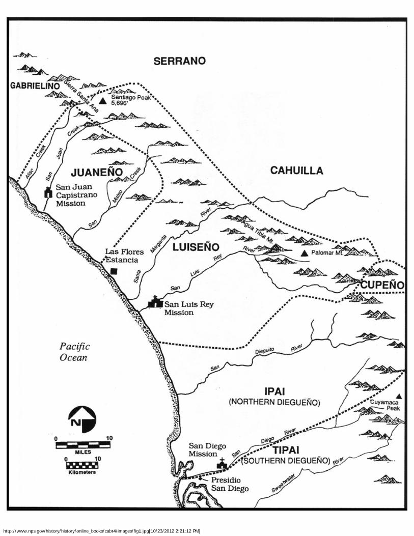
http://www.nps.gov/history/history/online_books/cabr4/images/fig1.jpg[10/23/2012 2:21:12 PM]

http://www.nps.gov/history/history/online_books/cabr4/images/fig2.jpg[10/23/2012 2:21:13 PM]

http://www.nps.gov/history/history/online_books/cabr4/images/fig3.jpg[10/23/2012 2:21:13 PM]

http://www.nps.gov/history/history/online_books/cabr4/images/fig4.jpg[10/23/2012 2:21:14 PM]
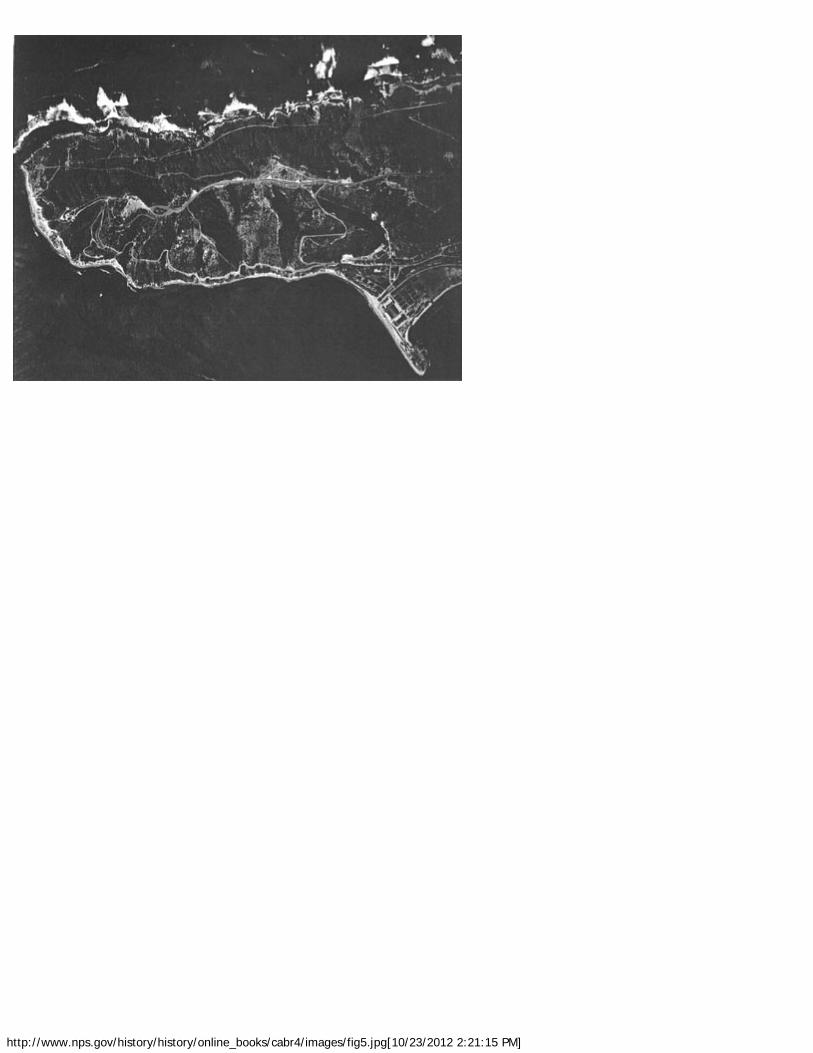
http://www.nps.gov/history/history/online_books/cabr4/images/fig5.jpg[10/23/2012 2:21:15 PM]

http://www.nps.gov/history/history/online_books/cabr4/images/fig6.jpg[10/23/2012 2:21:15 PM]

http://www.nps.gov/history/history/online_books/cabr4/images/fig7.jpg[10/23/2012 2:21:18 PM]

http://www.nps.gov/history/history/online_books/cabr4/images/fig7.jpg[10/23/2012 2:21:18 PM]
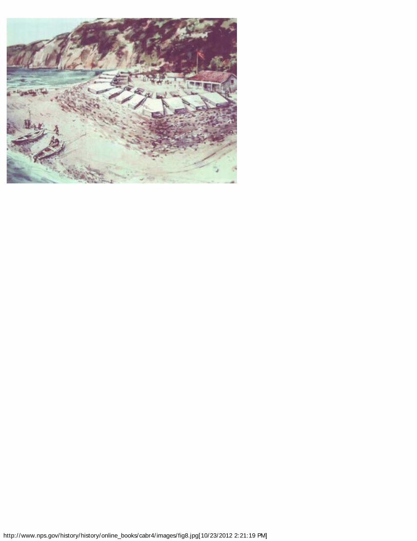
http://www.nps.gov/history/history/online_books/cabr4/images/fig8.jpg[10/23/2012 2:21:19 PM]

http://www.nps.gov/history/history/online_books/cabr4/images/fig9.jpg[10/23/2012 2:21:20 PM]

http://www.nps.gov/history/history/online_books/cabr4/images/fig10.jpg[10/23/2012 2:21:20 PM]

http://www.nps.gov/history/history/online_books/cabr4/images/fig11.jpg[10/23/2012 2:21:21 PM]

http://www.nps.gov/history/history/online_books/cabr4/images/fig12.jpg[10/23/2012 2:21:21 PM]
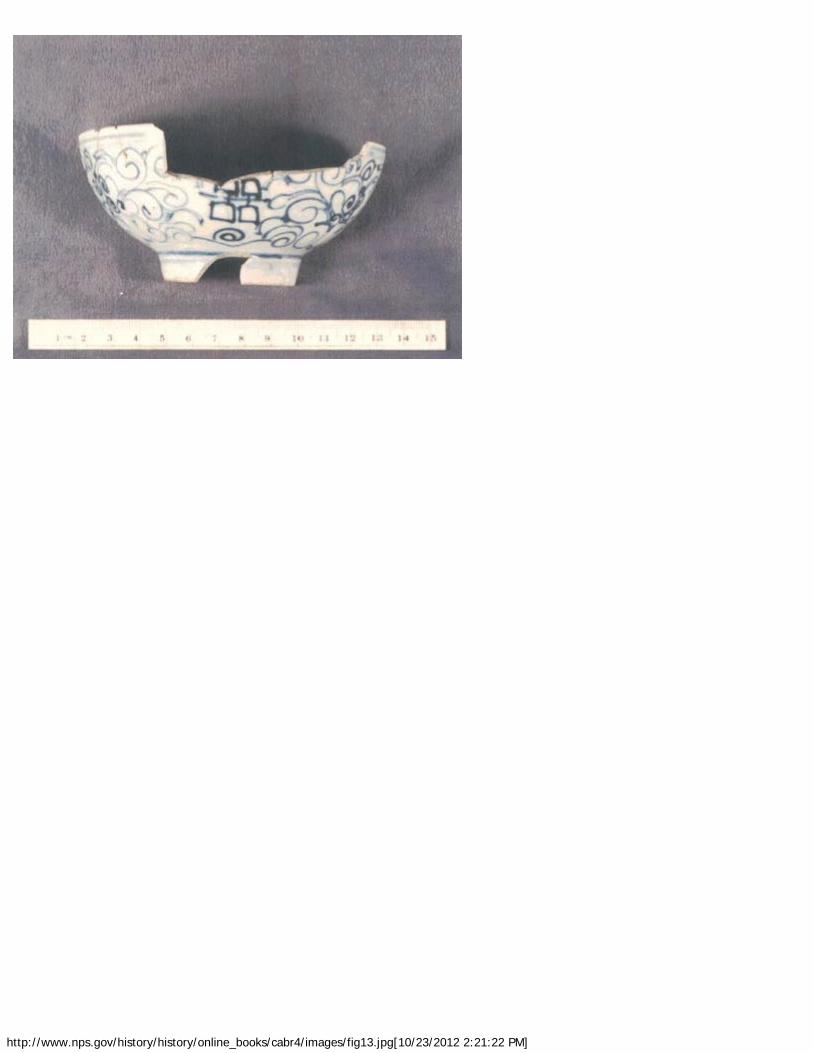
http://www.nps.gov/history/history/online_books/cabr4/images/fig13.jpg[10/23/2012 2:21:22 PM]

http://www.nps.gov/history/history/online_books/cabr4/images/fig14.jpg[10/23/2012 2:21:22 PM]
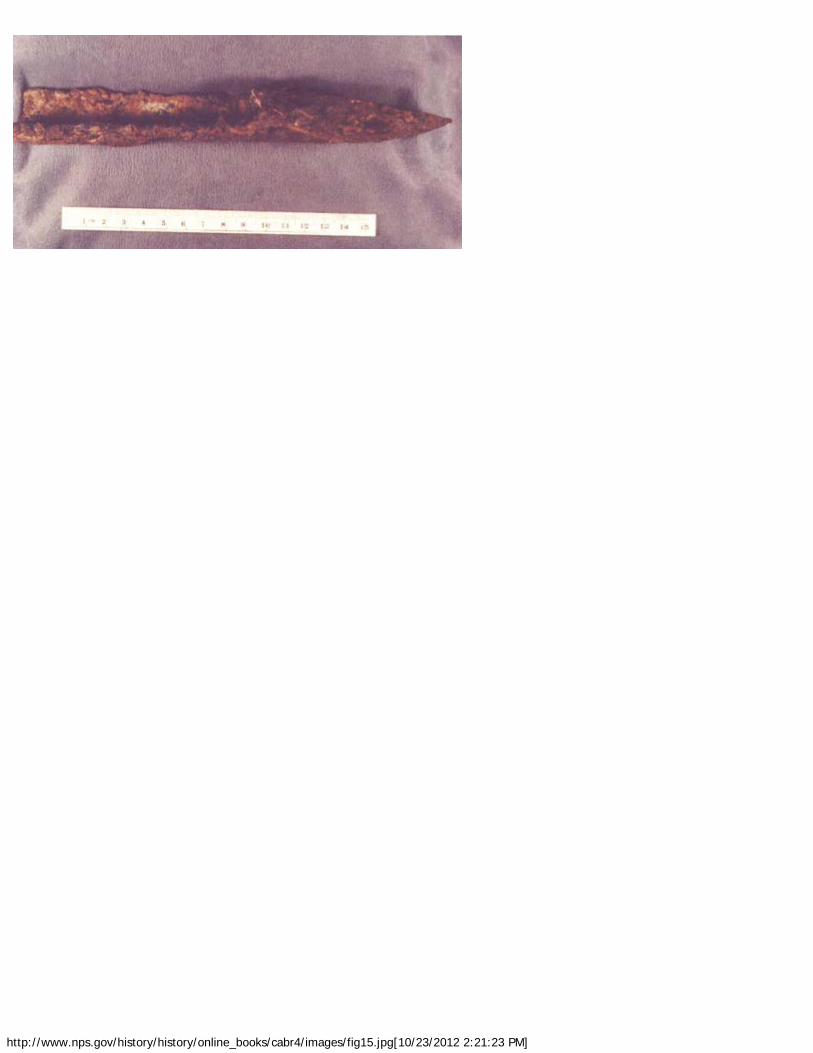
http://www.nps.gov/history/history/online_books/cabr4/images/fig15.jpg[10/23/2012 2:21:23 PM]

http://www.nps.gov/history/history/online_books/cabr4/images/fig16.jpg[10/23/2012 2:21:23 PM]

http://www.nps.gov/history/history/online_books/cabr4/images/fig17.jpg[10/23/2012 2:21:24 PM]

http://www.nps.gov/history/history/online_books/cabr4/images/fig18.jpg[10/23/2012 2:21:25 PM]

http://www.nps.gov/history/history/online_books/cabr4/images/fig18.jpg[10/23/2012 2:21:25 PM]

http://www.nps.gov/history/history/online_books/cabr4/images/fig19.jpg[10/23/2012 2:21:27 PM]

http://www.nps.gov/history/history/online_books/cabr4/images/fig20.jpg[10/23/2012 2:21:27 PM]
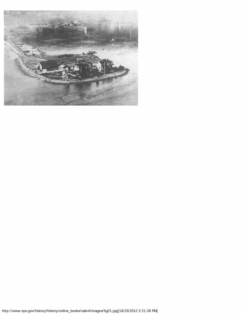
http://www.nps.gov/history/history/online_books/cabr4/images/fig21.jpg[10/23/2012 2:21:28 PM]

http://www.nps.gov/history/history/online_books/cabr4/images/fig22.jpg[10/23/2012 2:21:28 PM]
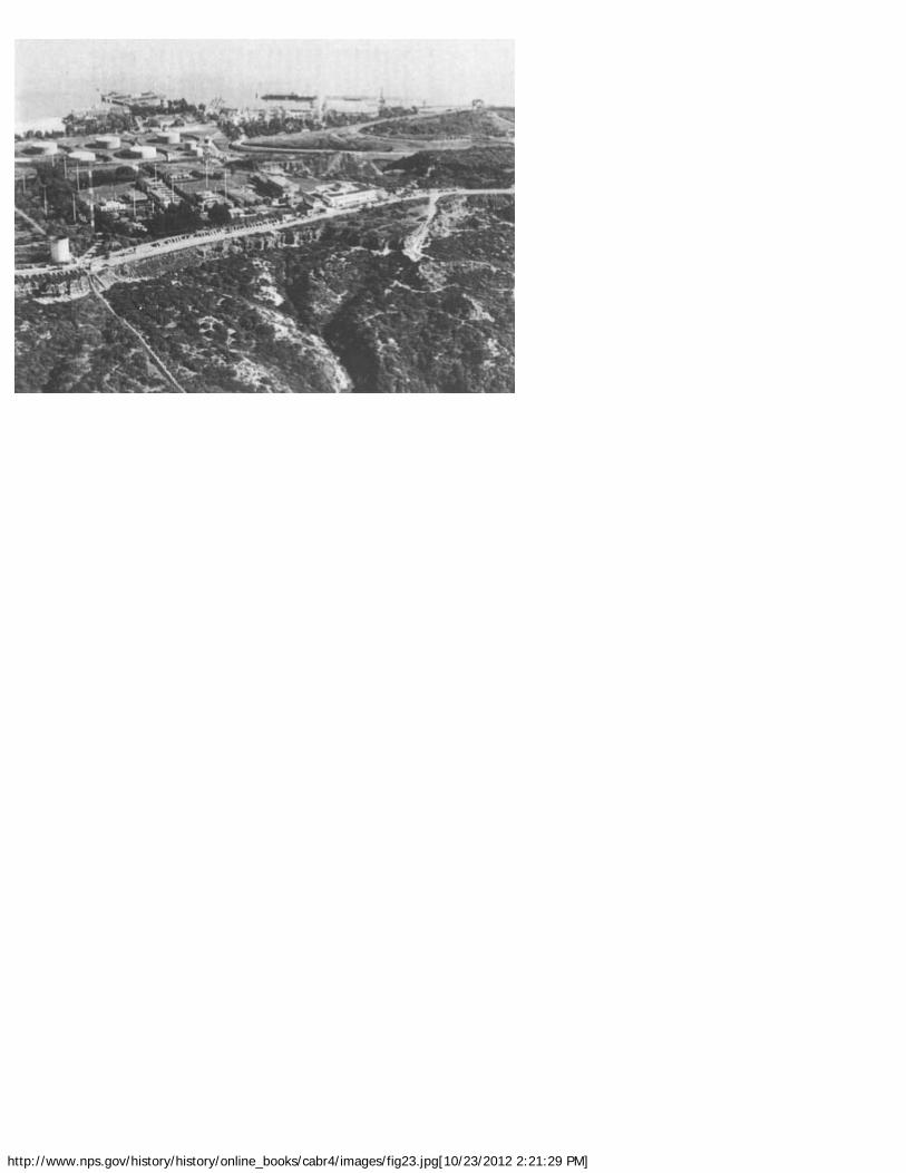
http://www.nps.gov/history/history/online_books/cabr4/images/fig23.jpg[10/23/2012 2:21:29 PM]

http://www.nps.gov/history/history/online_books/cabr4/images/fig24.jpg[10/23/2012 2:21:30 PM]

Cabrillo NM: Shadows of the Past (Chapter 1)
http://www.nps.gov/history/history/online_books/cabr4/chap1a.htm[10/23/2012 2:21:35 PM]
CABRILLO
Shadows of the Past
CHAPTER ONE:SHADOWS OF THE PAST AT CABRILLO NATIONAL MONUMENT(continued)
Figure 1: Native American and Spanish Colonial Settlements, ca. 1800 AD insouthern coastal California (Ronald May map). (click on image for an enlargement in
a new window)

Cabrillo NM: Shadows of the Past (Chapter 1)
http://www.nps.gov/history/history/online_books/cabr4/chap1a.htm[10/23/2012 2:21:35 PM]
Figure 2: Major Hartman Bache's late 1850s sketch of Point Loma peninsula, lookingnorthward from the Lighthouse location. Ridgetop roadway and settlement at Ballast
Point are visible (National Park Service photograph from National Archives).
Figure 3: Major Hartman Bache's late 1850s sketch of the Point Loma Lighthouse asseen from Ballast Point anchorage. Curving roadway to ridgetop from Ballast Point is
clearly visable (National Park Service photograph from National Archives).
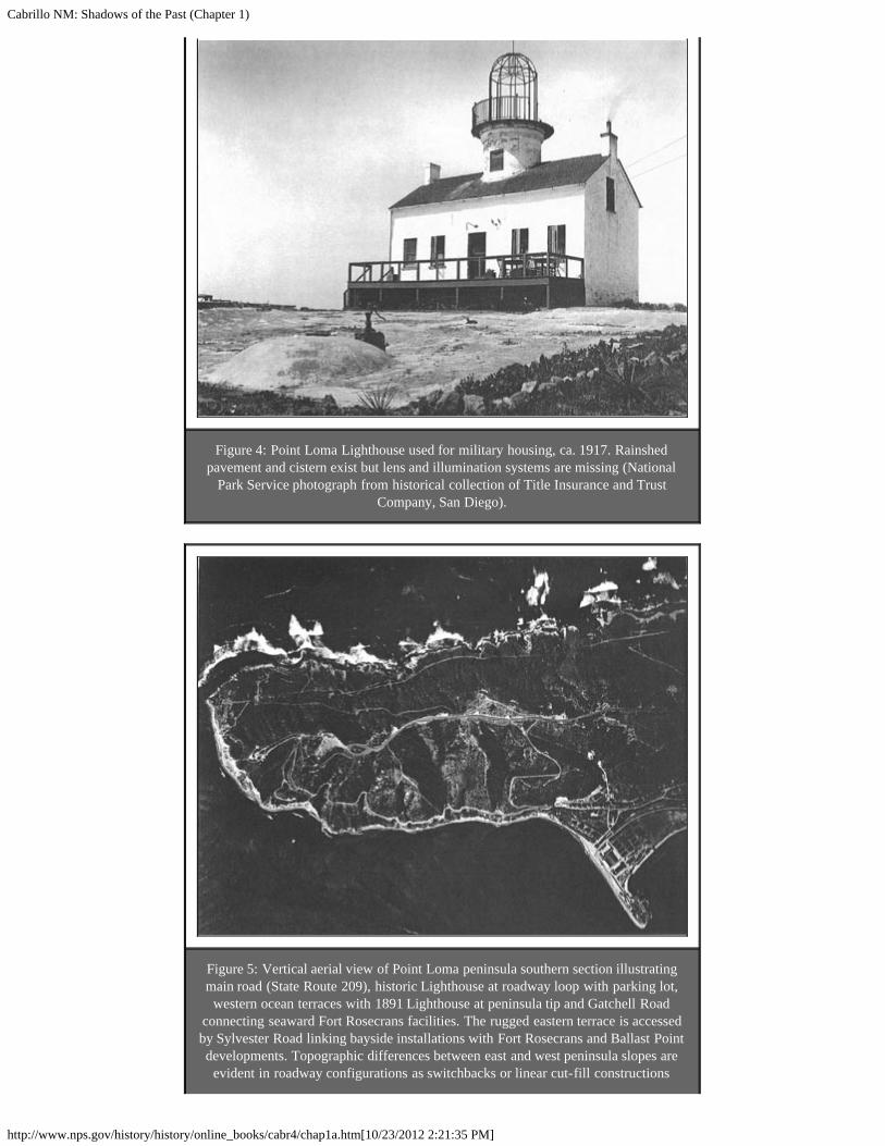
Cabrillo NM: Shadows of the Past (Chapter 1)
http://www.nps.gov/history/history/online_books/cabr4/chap1a.htm[10/23/2012 2:21:35 PM]
Figure 4: Point Loma Lighthouse used for military housing, ca. 1917. Rainshedpavement and cistern exist but lens and illumination systems are missing (National
Park Service photograph from historical collection of Title Insurance and TrustCompany, San Diego).
Figure 5: Vertical aerial view of Point Loma peninsula southern section illustratingmain road (State Route 209), historic Lighthouse at roadway loop with parking lot,
western ocean terraces with 1891 Lighthouse at peninsula tip and Gatchell Roadconnecting seaward Fort Rosecrans facilities. The rugged eastern terrace is accessedby Sylvester Road linking bayside installations with Fort Rosecrans and Ballast Pointdevelopments. Topographic differences between east and west peninsula slopes are
evident in roadway configurations as switchbacks or linear cut-fill constructions
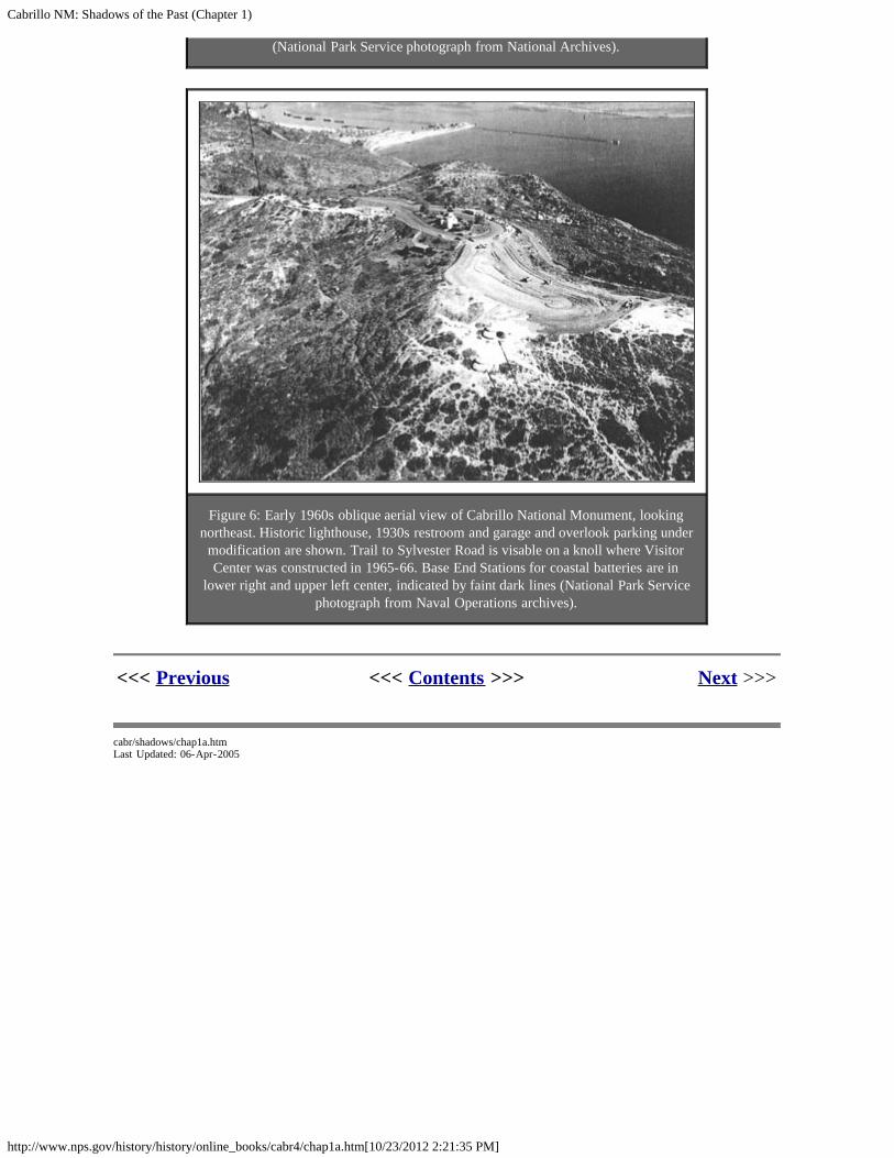
Cabrillo NM: Shadows of the Past (Chapter 1)
http://www.nps.gov/history/history/online_books/cabr4/chap1a.htm[10/23/2012 2:21:35 PM]
(National Park Service photograph from National Archives).
Figure 6: Early 1960s oblique aerial view of Cabrillo National Monument, lookingnortheast. Historic lighthouse, 1930s restroom and garage and overlook parking under
modification are shown. Trail to Sylvester Road is visable on a knoll where VisitorCenter was constructed in 1965-66. Base End Stations for coastal batteries are in
lower right and upper left center, indicated by faint dark lines (National Park Servicephotograph from Naval Operations archives).
<<< Previous <<< Contents >>> Next >>>
cabr/shadows/chap1a.htmLast Updated: 06-Apr-2005

Cabrillo NM: Shadows of the Past (Chapter 2)
http://www.nps.gov/history/history/online_books/cabr4/chap2a.htm[10/23/2012 2:21:39 PM]
CABRILLO
Shadows of the Past
CHAPTER TWO:OVERVIEW OF THE POINT LOMA PENINSULA PREHISTORY (continued)
RESEARCH DESIGN
One purpose of this overview is to provide meaningful ways to evaluate the scientific datapotential of the archaeology sites at Cabrillo National Monument within the broader researchcontexts under study by other researchers in the region. This includes a review of pastresearch and current criticism. Each site — known or to be discovered — will need to beevaluated for the spatial and vertical site complexity with a method proposed for qualitativeartifact or sample volumetric comparisons. Finally, there needs to be a definition of thephysical and cultural parameters required to design an archaeological mitigation program ortreatment plan to achieve conservation and to avoid impairment of archaeological resources.A research design supports positive resource management as expressed in park-widedocuments such as a general management plan and implemented through requiredcompliance steps for approval of management plans.
The following research domains are divided by primary research issues, each with testablequestions and potential archaeological data required to support sound scientific answers;
I. THE INTRA AND INTER SITE PATTERNING QUESTION
The first question posed to a field archaeologist after finding an archaeological site involvessite size, integrity, and importance. These questions relate to how archaeologists link that siteto broader patterns of prehistoric activities within a geographical region. A basic question iswhether or not the site has patterns of artifact features that relate to behavioral activities. Isthe site big enough and complex enough to contain kitchen, sleeping, tool repair ormanufacture, or religious activities and are those features large enough to be linked to othersites in the Point Loma area?
This theoretical overview will introduce interrelated problems of "inter-site" and "intra-site"patterning which form a physical basis for measuring quantity and quality of archaeologicalsites on the peninsula. From this physical basis, substantive research problems involving sitecomposition can be addressed. Ethnographic analogy will be reviewed as potential evidencefor site function interpretation. Research issues such as lithic technology, exchange and trade,subsistence and techno-economics, and ecological change with adaptation will then bepresented on the physical basis of site structure.
The primary assumption of intra-site pattern research is that prehistoric people's activitiesresulted in predictable patterns on the land. Those behaviors resulted in refuse that can bedistinguished by sets of artifacts and features. James N. Hill demonstrated residentialbehaviors as distinct from non-residential behaviors in rooms within Broken K Pueblo (aprehistoric Arizona village site) which led Michael A. Schiffer to attribute functional tasks torefuse disposal patterns (Hill 1968; Schiffer 1976). Schiffer's concept of artifact type sets forfunctions led to important debate on the theoretical approach to intra- and inter-site pattern

Cabrillo NM: Shadows of the Past (Chapter 2)
http://www.nps.gov/history/history/online_books/cabr4/chap2a.htm[10/23/2012 2:21:39 PM]
research.
Michael A. Jochim proposed inter-site patterning within regional catchment systems (1976)that required field definition of base camps and activity areas. John Yellen observed aconfusion of behaviors within site types, which he proposed as too many for usefulprediction (1977). Perhaps influenced by Jochim, Lewis R. Binford refuted Yellen withethnographic evidence of Eskimo hunting that correlated artifacts and features to base camps,seasonal, and special activity areas (1978:330-361; 1980:4-20; 1982:5-31).
The result of this energetic debate in the late 1970s and early 1980s was to crystallizetheoretical approaches to investigating spatial patterns of settlement within regional, as wellas behavior correlated artifact patterns within individual sites.
Geographic Site Typology
Within San Diego County, regional studies of site types over large tracts of land haveinvestigated a variety of correlated site types. Ronald V. May surveyed the Table Mountainarea of the Peninsular Mountains, east of Point Loma, and quantified plant and geologic unitswith types of sites to test cognitive land use patterns among Late Prehistoric people (1980).Pat Welch re-examined the Table Mountain data to correlate data sets with base camps, lithicscatters, and quarry sites (1980). More recently, Brian K. Glenn and Richard L. Carrico havecorrelated sets of features and artifacts from coastal prehistoric sites, such as diverse densitiesof bone and shell in greasy middens, to base camps (1995). Bryan F. Byrd and Carol Serrhave demonstrated specific artifact groups for resource procurement, processing, transport,and consumption found within inland sites between the Peninsular Mountains and PointLoma (1995).
Artifactual Data Sets and Site Types
Perhaps an even more stimulating research approach from the debates began with RobertWhallon's attempt to reconstruct tool kits within individual sites by functions (1973:16-34).James C. Bard and Colin I. Busby tested discrete living areas within sites by defining housefloor features and testing within sites in the Hotchkiss Archaeological District in ContraCosta County (1978). John Craib empirically mapped flaked stone, ground stone, boneartifacts, beads, and pottery with SYMAP, a computer software program that diagrams highand low artifact concentrations on a flat field, and then used data to infer primary activityareas such as residence behaviors based on fire-altered rocks (FAR), religious, andornamental objects (1982). Earlier, Ronald V. May, Stanley R. Berryman, and M. Jay Hatleycorrelated FAR ovens with residential camps near the coast of Del Mar (1976). The evidencemounted over time to suggest that intra-site artifact/feature functions within site structuredefined inter-site behavioral function within a settlement system.
Recently, researchers using large scale testing at Mill Creek in the Prado Basin of RiversideCounty have attempted to detect kitchen and residential areas by the presence of absence ofFAR rock ovens (Grenda 1995). Donn R. Grenda has used magnetometers to detectunderground fire hearths in an attempt to examine "male" versus "female" activity areas.
A. Research Hypotheses
1. The archaeology sites on the Point Loma Peninsula exhibit artifact and feature correlationsto landform, geological unit, and vegetation.
2. The artifact types and feature types at sites on the Point Loma Peninsula correlate toethnographic or published hypothetical behaviors.

Cabrillo NM: Shadows of the Past (Chapter 2)
http://www.nps.gov/history/history/online_books/cabr4/chap2a.htm[10/23/2012 2:21:39 PM]
3. The individual sites contain definable data sets known to correlate to site types such asbase camps, (also known as primary activity area) temporary camps, residential areas quarrysites, resource exploitation sites, and religious sites.
4. There is sufficient stratigraphic context in the sites to distinguish changes in intra sitebehavioral patterning.
5. The artifact types, quantities of artifacts, and features present in the sites are adequate tointerpret variation in activity areas within individual sites.
B. Data Requirements
Testing of the archaeology sites on the Point Loma Peninsula should orient data recoveries toanalyze spatial horizontal and vertical arrangements of artifact, ecofacts, and features againstpreviously defined inter and intra-site patterns.
1. Inter-site Patterns. Analysis of the archaeological sites should examine the presence orabsence of correlates to regional site types. Detection of inter-site functional types, the fieldsurvey, and test records should provide clues to prehistoric settlement systems on the PointLoma Peninsula.
Base camps and residential sites should be identifiable by multiple house floors or livingsurfaces, FAR rock hearth features, variations in marine shell features, variations in foodbone distribution, variations in cooking and butchering of food bone and dark midden soil.
Seasonal camps, temporary camps, or small residential sites should be identified by singlehouse floors or small living surfaces, one or two FAR rock hearths, shell and lithic reductionfeatures, and midden soil with low frequencies of marine shell and food bone.
Single activity areas or special activity areas should be identified as one or two features ofmarine shell, flaked stone, milling features and/or FAR hearths in shallow deposits.
Assay, mine, or quarry areas should be identified as primary lithic reduction features withmetavolcanic or quartzite cobbles assayed with less than ten cortex flakes removed. It wouldbe anticipated that mine or quarry sites on the Point Loma Peninsula would exploit cobblebeds in the reddish-orange Linda Vista Formation sandstone.
Sacred areas should be identified as stacks of rocks, rock alignments, or burial featuresexposed on eroded Linda Vista Formation sandstone. Stacks of rocks and rock alignmentsshould conform to ethnographic descriptions of Kumeyaay Sun solstice geoglyphs.
2. Intra-site Patterns. Analysis of archaeological sites should examine presence or absenceof feature correlates to behavioral patterning within individual site structure. Defined asfunctional areas, dispersed features within buried midden, strata, or alluvium-masked sitesshould be detected by shovel tests, hand-excavated units, and mechanical investigation.
Residential functions should manifest as house floors, FAR rock ovens, fire pits and ashlenses, artifact features, burials or religious features, clusters of ground bone or shell, clustersof flaked or ground stone, and clusters of marine shell or processed food bone in sufficienthorizontal and vertical quantities to indicate multiple behaviors over time. Classic house pitshave not been reported for the San Diego coastal sites, but post hole alignments and packedliving surfaces coincident with high frequencies of flaked and FAR stone artifacts shouldreflect living areas.
Specialized functions should exhibit artifact or feature data sets that are known to correlate to
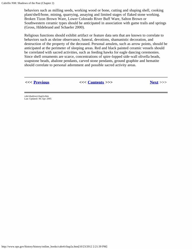
Cabrillo NM: Shadows of the Past (Chapter 2)
http://www.nps.gov/history/history/online_books/cabr4/chap2a.htm[10/23/2012 2:21:39 PM]
behaviors such as milling seeds, working wood or bone, cutting and shaping shell, cookingplant/shell/bone, mining, quarrying, assaying and limited stages of flaked stone working.Broken Tizon Brown Ware, Lower Colorado River Buff Ware, Salton Brown orSouthwestern ceramic types should be anticipated in association with game trails and springs(Gross, Hildebrand and Schaefer 2000).
Religious functions should exhibit artifact or feature data sets that are known to correlate tobehaviors such as shrine observance, funeral, devotions, shamanistic decoration, anddestruction of the property of the deceased. Personal amulets, such as arrow points, should beanticipated at the perimeter of sleeping areas. Red and black painted ceramic vessels shouldbe correlated with sacred activities, such as feeding hawks for eagle dancing ceremonies.Since shell ornaments are scarce, concentrations of spire-lopped side-wall olivella beads,soapstone beads, abalone pendants, carved stone pendants, ground graphite and hematiteshould correlate to personal adornment and possible sacred activity areas.
<<< Previous <<< Contents >>> Next >>>
cabr/shadows/chap2a.htmLast Updated: 06-Apr-2005

Cabrillo NM: Shadows of the Past (Chapter 2)
http://www.nps.gov/history/history/online_books/cabr4/chap2d.htm[10/23/2012 2:21:49 PM]
CABRILLO
Shadows of the Past
CHAPTER TWO:OVERVIEW OF THE POINT LOMA PENINSULA PREHISTORY (continued)
References
Arkush, Brooke S.1989 Review of Archaeological Investigations at CA-RIV-1179, CA-RIV-2823, and CA-RIV-2827, La Quinta, Riverside County, California. Mark Q. Sutton and Philip J. Wilke,editors. Journal of California and Great Basin Anthropology 11:281-83.
Arnold, Brigham A.1957 Late Pleistocene and Recent Changes in Land Forms, Climate, and Archaeology inCentral Baja California. University of California Publications in Geography 10(4): 201-318.University of California Press: Los Angeles.
Arnold, Jeanne1992 Complex Hunter-Gatherer-Fishers of Prehistoric California: Chiefs, Specialists andMaritime Adaptation of the Channel Islands. American Antiquity 64(1): 60-84.
Aschmann, Homer1959 The Evolution of a Wild Landscape and its Persistence in Southern California. Man,Time and Space in Southern California (Ed.) William L. Thomas, pp. 34-57. Annals of theAmerican Association of American Geographers.
Banks, Thomas Jeffrey1971 Geologic Obsidian Sources for Baja California. Pacific Coast Archaeological SocietyQuarterly 6(1): 35-40. Costa Mesa.
Bard, James C. and Colin l. Busby1978 An Evaluation of the Hotchkiss Archaeological District. Public Works Department,Contra Costa County, Martinez, California.
Barker, Richard M.1970 Constituency and Origins of Cyclic Layers in Pellecypod Shells. Space SciencesLaboratory Series 13(43). University of California, Berkeley.
Barrows, David Prescott1900 The Ethnobotany of the Coahuilla Indians of Southern California. University ofChicago Press.
Baumgartner, Tim1978 Personal Communication.
Bean, Lowell John and Katherine Saubel1972 Temalpakh: Cahuilla Indian Knowledge and Usage of Plants. Malki Museum Press,Banning, California.

Cabrillo NM: Shadows of the Past (Chapter 2)
http://www.nps.gov/history/history/online_books/cabr4/chap2d.htm[10/23/2012 2:21:49 PM]
Berger, Rainer, Homey, and Libby1964 Radiocarbon Dating of Bone and Shell and Their Organic Components, Science,Volume 144, Number 3621, pp. 999-1001.
Berryman, Judy1981 Archaeological Mitigation Report of Santee Greens, SDi-5669. Ms. on file, SouthCoastal Information Center, San Diego State University, San Diego.
Binford, Lewis1978 Dimensional Analysis of Behavior and Site Structure: Learning From An EskimoHunting Stand. American Archaeology 43:330-361.
1980 Willow Smoke and Dog's Tails: Hunter-Gatherer Settlement Systems andArchaeological Site Formation. American Antiquity 45 (1): 4-20.
Bright, M.1965 California Radiocarbon Dates. Archaeological Survey Annual Report (7): 363-375.
Breschini, Gary S., Trudy Haverstat, and Jon Erlandson1986 California Radiocarbon Dates. Coyote Press, Salinas, California.
Brott, Clark1966 Part V, How Stones Became Tools and Weapons, Ancient Hunters of the Far West. SanDiego: Copley Press.
Bull, Charles1977 Archaeology and Linguistics, Coastal Southern California. Master's Thesis, Departmentof Anthropology, San Diego State University.
1983 Shaking the Foundations: The Evidence for San Diego Prehistory. Casual Papers 1(3):15-64. Cultural Resource Management Center. San Diego State University.
1987 A New Proposal: Some Suggestions for San Diego Prehistory. San Dieguito-La Jolla:Chronology and Controversy, (Ed.) Dennis Gallegos, San Diego County ArchaeologicalSociety Research Paper 1. San Diego.
Byrd, Bryan F. and Carol Serr1993 Multi-Component Archaic and Late Prehistoric Residential Camps Along theSweetwater River, Rancho San Diego, California. Brian F. Mooney AssociatesAnthropological Technical Series l. San Diego.
Campbell, Elizabeth W. Crozier1936 Archaeological Problems in the Southern California Deserts. American Antiquity 4:295-300.
Campbell, Elizabeth W. Crozier, William H. Campbell, Ernst Antevs, Charles AveryAmsden, Joseph A. Barbieri, and Francis D. Bode1937 The Archaeology of Pleistocene Lake Mojave: A Symposium. Southwest MuseumPapers. Number 11.
Cardenas, D. Sean and Mary Robbins-Wade1985 An Archaeological Investigation of SDM-W-143/146: An Unique Coastal LuiseñoOccupation Site in Carlsbad, California. RBR & Associates.
Cabrillo NM: Shadows of the Past (Chapter 2)
http://www.nps.gov/history/history/online_books/cabr4/chap2d.htm[10/23/2012 2:21:49 PM]
Cardenas, D. Sean1986 Avocado Highlands: An Inland Late La Jolla and Preceramic Yuman Site fromSouthern San Diego County. Casual Papers, Cultural Resource Management 2(2):59-84.
Carrico, Richard and Sandra Day1981 Archaeological Investigations at Ystagua: A Late Prehistoric Village Complex (TheHallmark Circuits/Cavanaugh Properties: SDI-5443). Westec Services.
Carrico, Richard and Peter Ainsworth1980 Archaeological Salvage at W-192A, Imperial Beach, California. Ms. at South CoastInformation Center.
Carrico, Richard, Theodore Cooley and Joyce Clevenger1990 Archaeological Excavation at the Harris Site Complex, San Diego County, California.Ogden Environmental and Energy Services Company, San Diego, California.
Carrico, Richard and Clifford Taylor1983 Excavation of a Portion of Ystagua: A Coastal Valley Ipai Settlement. Westec Services.Ms. South Coast Information Center.
Carrico, Richard1975 Rimbach Property Archaeology Report. Westec Services.
1986 Strangers in a Stolen Land. San Diego State University.
Carter, Christina1978 Seasonality Analysis of CA-LAN-702. Pacific Coast Archaeological Society Quarterly14(2):52-56. Costa Mesa.
Carter, George1957 Pleistocene Man at San Diego. The Johns Hopkins Press: Baltimore.
Castetter, Edward F., Willis H. Bell, and Alvin R. Grove1938 Ethnobiological Studies in the American Southwest: VI. The Early Utilization and theDistribution of Agave in the American Southwest. University of New Mexico Bulletin,Biological Series 5(4).
Cerreto, Richard1988 Section 9 Marine Invertebrate Analysis. Five Thousand Years of Maritime Subsistenceat Ballast Point Prehistoric Site SDI-48 (W-164) San Diego, California. Dennis Gallegos andCarolyn Kyle, Ms. prepared for the United States Navy by Westec Services.
Chartkoff, Joseph and Kerry Chartkoff1984 The Archaeology of California. Stanford University Press, Stanford, California.
Christenson, Lynne E.1990 The Late Prehistoric Yuman People of San Diego County, California: Their Settlementand Subsistence System. Ph.D. dissertation, Department of Anthropology, Arizona StateUniversity.
1992 The Late Prehistoric Yumans: Their Settlement and Subsistence System. Essays on thePrehistory of Maritime California, (Ed.) Terry Jones. Publications of the Center forArchaeological Research at Davis Number 10. University of California, Davis.
Clevenger, Joyce
Cabrillo NM: Shadows of the Past (Chapter 2)
http://www.nps.gov/history/history/online_books/cabr4/chap2d.htm[10/23/2012 2:21:49 PM]
1995 Personal Communication.
Colten, Roger H. and Jeanne Arnold1998 Prehistoric Marine Mammal Hunting on California's Northern Channel Islands.American Antiquity. 63(4):679-701.
Cook, John R. and Scott Fulmer1980 The Archaeology and History of the McCain Valley Study Area, Eastern San DiegoCounty, California: A Class II Cultural Resource Inventory. ASM, San Diego and SouthCoast Information Center.
Cook, John1978 Archaeological Mitigation of Woodside Hills. Ms. at the South Coast InformationCenter.
Corum, Joyce M. and Chris White1986 Extended Phase I and Phase II Archaeological Test Excavations at Site CA-SDI-9243.Caltrans District 11, San Diego.
Corum, Joyce M.1986 Extended Phase I and Phase II Archaeological Test Excavations at Sites CA-SDi-205,5053, 8594, 9242, and 10, 148, Santee, California. Caltrans, District 11, San Diego.
1991 Phase II Archaeological Test Excavation at Site CA-SDi-5445, City of Oceanside,California Caltrans, District 11, San Diego.
Coutts, P. and C. Higham1971 The Seasonal Factor in Prehistoric New Zealand. World Archaeology 2:266-277.
Craib, John1982 The Archaeology of a Late Horizon Midden (CA-Ora-197) On Newport Bay. PacificCoast Archaeological Society Quarterly, Volume 18, Numbers 2 and 3. Costa Mesa.
Curray, J.R.1965 Late Quaternary History: Continental Shelves of the United States. (In) The Quaternaryof the United States, (Ed.) H.E. Wright, Jr. and D.G. Freys, pp. 723-735. PrincetonUniversity Press, Princeton, New Jersey.
Davis, Emma Lou1968 Archaic of Eastern California. Archaic Prehistory in the Western United States. EasternNew Mexico University Contributions in Anthropology, Volume 1, Number 3, pp. 15-19.Portales, New Mexico.
1969 The Western Lithic Co-Tradition. San Diego Museum of Man Papers, Number 6. SanDiego.
1976 Two Dated La Jollan Burials and Their Place in California Prehistory: A Review,Pacific Coast Archaeological Society Quarterly 12(4):1-44.
Davis, James T.1962 The Rustler Rockshelter Site (SBr-288), A Culturally Stratified Site in the MohaveDesert, California. University of California Archaeological Survey Report 57, Part II, pp. 25-56. Berkeley.
Deetz, James

Cabrillo NM: Shadows of the Past (Chapter 2)
http://www.nps.gov/history/history/online_books/cabr4/chap2d.htm[10/23/2012 2:21:49 PM]
1965 The Dynamics of Stylistic Change in Arikara Ceramics. Chicago: University of IllinoisPress.
Demcak, Carol Romana1981 Fused Shale as Time Marker in Southern California: Review and Hypothesis. Mastersthesis, Department of Anthropology, California State University, Long Beach.
Douglas, Ronald D.1981 An Archaeological Reconnaissance in Arriba de Arroyo Matomi, Baja California,Mexico. Pacific Coast Archaeological Society Quarterly 17(1):63-69.
Drover, Christopher E.1974 Seasonal Exploitation of Chione Clams on the Southern California Coast. Journal ofCalifornia Anthropology 1(2):224-232. Malki Museum Press: Banning, California.
1975 Early Ceramics from Coastal Southern California. Journal of California Anthropology2(1): 101-7. Malki Museum Press: Banning, California.
1978 Prehistoric Ceramic Objects from Catalina Island. Journal of California Anthropology5(1):78-83. Malki Museum Press: Banning, California.
Dominici, Deb1984 Calibration of the Obsidian Butte Hydration Rate and Its Implications Regarding LatePrehistoric Exchange. Master's thesis, Department of Anthropology, San Diego StateUniversity.
1985 Data Recovery Report of Archaeological Phase III Excavation and Analysis of CA SDI-5680 (Nelson Site). Caltrans, District 11, San Diego.
Dubois, Constance Goddard1908 The Religion of the Luiseño Indians of Southern California. University of CaliforniaPublications in American Archaeology and Ethnology 8(3):69-173. Berkeley.
Eidsness, Janet, Douglas Flower, Darcy Ike and Linda Roth1979 Archaeological Investigations of the Impink Project, 35.13 Acres, North Jamul,California, SDM-W-2 164.
Erickson, Jonathon Edward1977 Prehistoric Exchange Systems in California: The Results of Obsidian Dating andTracing. Ph.D. dissertation, Department of Anthropology, San Diego State University.
1981 Exchange and Production Systems in California Prehistory: The Results of HydrationDating and Chemical Characterization of Obsidian Sources. British Archaeological ReportsNumber 110.
Ezell, Paul1968 Personal Communication.
1987 The Harris Site-An Atypical San Dieguito Site, or Am I Beating a Dead Horse? SanDieguito-La Jolla: Chronology and Controversy, (Ed.) Dennis Gallegos, pp. 15-22, SanDiego County Archaeological Society Research Paper Number 1.
1970 Personal Communication.
Flower, Douglas M., Darcy Ike, and Linda Roth

Cabrillo NM: Shadows of the Past (Chapter 2)
http://www.nps.gov/history/history/online_books/cabr4/chap2d.htm[10/23/2012 2:21:49 PM]
1977 Archaeological Investigations at W-137. Flower, Ike, and Roth.
Fulmer, Scott1984 Request for Determination of Eligibility for Inclusion on the National Register ofHistoric Places for Archaeology Site CA-SDi-5589, The Bonsall Site. Caltrans, District 11,San Diego.
Gallegos, Dennis and Richard Carrico1984 Windsong Shores Data Recovery Program for Site W-131 Carlsbad, California. Ogden.
Gallegos, Dennis and Carolyn Kyle1988 Five Thousand Years of Maritime Subsistence at Ballast Point Prehistoric Site SDI-48(W-164), San Diego, California. Ogden.
Gallegos, Dennis and Carolyn Kyle1989 Early Period Occupation at the Kuebler Ranch Site Sdi8654, Otay Mesa, San DiegoCounty, California. Gallegos & Associates.
Gallegos, Dennis1985 Batiquitos Lagoon Revisited. Casual Papers. (Ed.) Chris White, Volume 2, Number 1.Cultural Resource Management Center, Department of Anthropology, San Diego StateUniversity. San Diego, California.
1987 A Review and Synthesis of Environmental and Cultural Material for the BatiquitosLagoon Region. SD CA S Research Paper Number 1. San Diego County ArchaeologicalSociety: San Diego.
1991 Antiquity and Adaptation at Agua Hedionda, Carlsbad, California. Hunter Gatherers ofEarly Holocene Coastal California, Perspectives in California Archaeology 1. Institute ofArchaeology, University of California, Los Angeles.
1991 Antiquity and Adaptation at Agua Hedionda, Carlsbad, California. Hunter-gatherers ofEarly Holocene Coastal California Perspectives in California Archaeology, Volume 1. (Eds.)J.M. Earlandson and T.K. Rockwell. Institute of Archaeology, University of California, LosAngeles.
Gifford, E.W.1940 California Bone Artifacts. Anthropological Records 3(2). University of California Press:Berkeley.
Glenn, Brian and Richard Carrico1995 A Cultural Resources Technical Report for the Santa Fe Valley Specific Plan EIR, SanDiego County, California. Ms. at South Coast Information Center.
Greenwood, Roberta1972 9,000 Years of Prehistory at Diablo Canyon, San Luis Obispo County, California. SanLuis Obispo County Archaeological Society Occasional Paper, Number 7, San Luis Obispo.
Grenda, Donn R.1995 Prehistoric Game Monitoring on the Banks of Mill Creek, Data Recovery at CA-RIV-2804, Prado Basin, Riverside County, California. Statistical Research Technical SeriesNumber 52. Prepared for United States Army Corps of Engineers, Los Angeles District.
Gross, Timothy and Michael Sampson1990 Archaeological Studies of Late Prehistoric Sites in the Cuyamaca Mountains, San

Cabrillo NM: Shadows of the Past (Chapter 2)
http://www.nps.gov/history/history/online_books/cabr4/chap2d.htm[10/23/2012 2:21:49 PM]
Diego County, California. Proceedings of the Society for California Archaeology 3:135-148.
Gross, Timothy1995 Personal Communication.
Haury, Emil1950 The Stratigraphy and Archaeology of Ventana Cave, Arizona. University of NewMexico Press.
Hayden, Julian D.1966 Restoration of the San Dieguito Type Site to Its Proper Place in the San DieguitoSequence. American Antiquity 31(3): 439-40.
1987 Notes on The Apparent Course of San Dieguito Development. San Dieguito-La Jolla:Chronology and Controversy, (Ed.) Dennis Gallegos, pp. 44-47. San Diego CountyArchaeological Society Paper l. San Diego.
Hector, Susan and Wade1986 Excavation of a Portion of SDI-4513, the Rimbach Site, City of San Diego, California.RECON, San Diego.
Hector, Susan1983 Archaeological Excavation of SDi-5601 (SDM-W-1293), Carlsbad. RECON. SanDiego.
1984 Late Prehistoric Hunter-Gatherer Activities in Southern San Diego, California. Ph.D.dissertation, Department of Anthropology, University of California, Los Angeles.
1985 Excavations at SDI-4609, A Portion of the Village of Ystagua, Sorrento Valley,California. RECON, San Diego.
1988 The Identification of Activity Areas with Late Prehistoric Sites: A Case Study of theRimbach Site, San Diego, California. Proceedings of the Society for California Archaeology1:55-74.
Heizer, Robert F. and Thomas R. Hester1978 Great Basin. Chronologies in New World Archaeology. (Ed.) R.E. Taylor and ClementMeighan, pp. 147-199. Academic Press: New York.
Heutt, Mary Lou1979 Preliminary Archaeological Investigations at the Village of La Rinconada de Jamo,SDMW-150. Archaeological Consulting & Technology.
Hicks, Frederick Noble1963 Ecological Aspects of Aboriginal Culture in the Western Yuma Area. Ph.D.dissertation, Department of Anthropology, University of California, Los Angeles.
Hill, J.N.1968 Broken K Pueblo: Patterns of Form and Function. New Perspectives in Archaeology.(Ed.) S.R. Binford and L.R. Binford, pages 103-142. Aldine, Chicago.
Hoover, Robert L.1973 Chumash Fishing Equipment. San Diego Museum of Man Ethnic Technology Notes,Number 9. San Diego.
Cabrillo NM: Shadows of the Past (Chapter 2)
http://www.nps.gov/history/history/online_books/cabr4/chap2d.htm[10/23/2012 2:21:49 PM]
Hubbs, Carl and Jacqueline Miller1970 A Mechanical Shell Washer. Veliger 12(3): 379-80.
Hubbs, Carl, George S. Bien and Hans E. Seuss1960 La Jolla Natural Radiocarbon Measurements. American Journal of Science,Radiocarbon Supplement 2:197-223.
1962 La Jolla Natural Radiocarbon Measurements III. American Journal of Science:Radiocarbon Supplement 4:204-238.
Hubbs, Carl1955 Water, Fish and Man in Southern California. Southern California Academy of Science54(3).
1958 Recent Climatic History in California and Adjacent Areas. Proceedings of Conferenceon Recent Research in Climatology, Scripps Institution of Oceanography, La Jolla,California, March 25-26, 1957. Issued by Committee on Research in Water Resources,University of California, pp. 10-11.
1959 Recent Climatic history in California. Minutes of Semi-annual Convention, IrrigationDistrict Association of California, Santa Barbara, December 10-12, 1958, pp. 43-47.
1960 Quaternary Paleoclimatology of the Pacific Coast of North America. CaliforniaCooperative Oceanic Fisheries Investigations Report Number 2. Page 201.
1961 Some Highlights From the Natural Radiocarbon Datings of La Jolla Laboratory.(Abstract) Science 134(3488): 1430.
1964 Oceanography and Marine Life Along the Pacific Coast of Middle America. Handbookof Middle American Indians. University of Texas Press: Midland. pp. 143-186.
1965 Past and Present Coastline Ocean Temperatures. Report on Symposium, the MarineEnvironment. Final Report of the Junior College Workshop in Biology, southern CaliforniaSection, California State Department on Education 6:30-36.
Hughes, R.E. and D.L. True1985 Perspectives On The Distribution of Obsidians in San Diego County, California. NorthAmerican Archaeologist 6(4): 325-339.
Hughes, Richard E. and D.L. True1985 Perspectives on the Distribution of Obsidians in San Diego County, California. NorthAmerican Archaeologist 6:325-339.
Hughes, Richard E.1986 Trace Element Composition of Obsidian Butte, Imperial County, California. Bulletin ofthe Southern California Academy of Sciences 85:35-45.
Inman, D.L., R.T. Guza, D.W. Skelly, and T.E. White1986 Southern California Coastal Processes Data Summary, Coast of California Storm andTidal Wave Study. United States Army Corps of Engineers, Los Angeles District ReferenceNumber CCSTWS 86-1:572. Los Angeles, California.
Inman, D.L., C.E. Nordstrom, S.S. Pawka, D.G. Aubrey, and L.C. Holmes1974 Nearshore Processes Along the Silver Strand Littoral Cell, La Jolla, California. InterseaResearch Corporation Report #72.

Cabrillo NM: Shadows of the Past (Chapter 2)
http://www.nps.gov/history/history/online_books/cabr4/chap2d.htm[10/23/2012 2:21:49 PM]
Inman, D.L.1983 Application of Coastal Dynamics to the Reconstruction of Paleocoastlines in theVicinity of La Jolla, California. Quaternary Coastlines of California Storm and Tidal WaveStudy. United States Army Corps of Engineers, Los Angeles District, Reference NumberCCSTWS 86-1:572. Los Angeles.
Jochim, Michael A.1976 Hunter-Gatherer Subsistence and Settlement: A Predictive Model. Academic Press,New York.
Jones, Terry L.1992 Settlement Trends Along The California Coast. Essays on the Prehistory of MaritimeCalifornia. (Ed.) Terry L. Jones, pages 1-37. Center for Archaeological Research at Davis,Publication Number 10. University of California, Davis.
Kaldenberg, Russell and Charles S. Bull1975 Archaeological Investigations at Rancho Del Dios, Units 1 and 2, Rancho Santa Fe,California. Ms. at South Coast Information Center, San Diego State University.
Kaldenberg, Russell1982 Rancho Park North, A San Dieguito-La Jolla Shellfish Processing Site on CoastalSouthern California. Occasional Paper Number 6. Imperial College Museum Society: ElCentro, California.
Kennedy, George L.1995 Personal Communication.
Killingsley, John S. and Wolfgang H. Berger1979 Stable Isotopes in a Mollusk Shell: Detection of Upwelling Events. Science 205:196-188. American Association for the Advancement of Science, Washington, D.C.
1980 Seasonality of Mollusk Collecting at Hubb's Midden Site 1959:VI: 28A. Pacific CoastArchaeological Society Quarterly 16(4): 19-23.
Koerper, Henry C., Adella Schroth and Paul Langenwalter1991 Early Holocene Adaptation and Transition Phase Problem: Evidence for the Allan O.Kelley Site, Agua Hedionda Lagoon. Hunter-Gatherers of Early Holocene CoastalCalifornia. (Ms.) Jon M. Erlandson and Roger H. Colten, pp. 43-62. Perspectives inCalifornia Archaeology 1, University of California, Los Angeles.
Koerper, Henry C.1980 Comments on Drover's Proposed Seasonality Method. Journal of California and GreatBasin Anthropology 2:137-140.
Koerper, Henry C., Richard Cerreto, and Karl P. Reitz1984 Cautionary Notes on the Use of a Statistical Method of Seasonality Determination fromChione undatella Shells. Pacific Coast Archaeological Society Quarterly 20(3): 67-75.
Kroeber, Alfred L.1925 Handbook of the Indians of California. Bureau of American Ethnology, Bulletin 78.
Kuhn, Thomas1970 Structure of Scientific Revolution.
Lanning, Edward P.

Cabrillo NM: Shadows of the Past (Chapter 2)
http://www.nps.gov/history/history/online_books/cabr4/chap2d.htm[10/23/2012 2:21:49 PM]
1963 Archaeology of the Rose Spring Site Iny-372. University of California Publications inAmerican Archaeology and Ethnology 49(3): 237-336.
Laylander, Don and Lynne E. Christenson1988 Results of a Data Recovery Program for Corral Canyon Prehistoric ArchaeologicalDistrict, San Diego County, California. Cleveland National Forest, Escondido, California.
Laylander, Don and Dan Saunders1992 Donax Exploitation on the Pacific Coast: Spatial and Temporal Limits. Ms. at SouthCoast Information Center; 1993 Donax Exploitation on the Pacific Coast: Spatial andTemporal Limits. Proceedings of Society for California Archaeology Volume 6. San Diego.
Laylander, Don1986 Final Report of Archaeological Test Excavations at Sites CA-SDI-1 103, CA-SDI-4615, CA-SDI-4627, CA-SDI-4629, CA-SDI-8121, CA-SDI-10,143 and CA-SDI-10,144,San Diego County, California. Ms. on file at Caltrans, San Diego.
1989 Phase II Archaeological Investigations at Site CA-SDI-5383, Penasquitos Area, SanDiego, California. Caltrans District 11, San Diego.
1991 Phase II and Extended Phase I Tests at Seven Prehistoric Archaeological Sites (CAImp-6297/6298, 6417, 6419, 6425, 6427, and 6429) in the Kane Spring Area, ImperialCounty, California. Caltrans District 11, San Diego, California.
1992 Research Issues in San Diego Archaeology. San Diego County Archaeological Society:San Diego.
Libby, W.F.1952 (Chicago III), Chicago Radiocarbon Dates, III, Science, Volume 116, pp. 673-681.Chicago.
Linick, Timothy1977 La Jolla Radiocarbon Measurements VII. Radiocarbon 4:204-238.
Luomala, Katherine1978 Flexibility in Sib Affiliation Among the Diegueno. Native Californians: A TheoreticalRetrospective. (Ed.) Robert F. Heizer, pp. 592-609. Handbook of North American Indians,Volume 8, William G. Sturtevant, general editor.
Lyons, Edward1978 A Statistical Method of Seasonality Determination form Chione undatella (Sowerby).Pacific Coast Archaeological Society Quarterly 14(3): 33-41.
Macko, Michael E.1983 Beads, Bones, Baptism, and Sweatlodges: Analysis of Collections from "Elijman" (CA-Ba-485), a Late Period Ynezeno Chumash Village in the Central Santa Ynez Valley,California. Master's thesis, Department of Anthropology, University of California, SantaBarbara.
Masters, Patricia1988 Section 4 Paleo-Environmental Reconstruction of San Diego Bay, 10,000 Years B.P. ToPresent, Five thousand Years of Maritime Subsistence at Ballast Point Prehistoric Site SDi-48(W-164) San Diego, California. Westec Services.
May, Ronald V.
Cabrillo NM: Shadows of the Past (Chapter 2)
http://www.nps.gov/history/history/online_books/cabr4/chap2d.htm[10/23/2012 2:21:49 PM]
1971 A Preliminary Report on the Archaeological Highway Salvage at Cottonwood Creek (4-SDi-777). Caltrans, District 11, San Diego.
1972 Preliminary Report of the Mexican Majolica from the San Diego Presidio. Mark R.Barnes, Ronald V. May, Mexican Majolica in Northern New Spain. Pacific CoastArchaeological Society Occasional Paper Number 2. Costa Mesa.
1974a Tizon Brown Ware in Southern California. Paper delivered to the Society forCalifornia Archaeology Annual Meeting.
1974b Suggestive Evidence of Prehistoric Contact Between Southern California and SouthernArizona: Two Cremations From San Diego County, California. San Diego CountyArchaeological Society Paper Number 1. San Diego.
1975 A Brief Survey of Kumeyaay Ethnography: Correlations Between Environmental LandUse Patterns, Material Culture, and Social Organization. Pacific Coast ArchaeologicalSociety Quarterly 11(4): 1-25. Costa Mesa.
1976 The Archaeology of Loma Del Cielo: An Analysis of Paleo-Indian Fire Hearths and AnAssociated Workshop. Pacific Coast Archaeological Society Quarterly 12(4). Costa Mesa.
1976 An Early Ceramic Date Threshold in Southern California. The Masterkey 50(3): 103-107. Southwest Museum: Los Angeles.
1978 A Southern California Indigenous Ceramic Typology: A Contribution to Malcolm J.Rogers' Research. Journal of the Archaeological Survey Association of Southern California2(2).
1980 Geologic and Biologic Determinants of the Table Mountain Complex: The DesertTransition of the Jacumba Pass, Pacific Coast Archaeological Society Quarterly 16(3): 53-63.
1982 The Development of the Early Milling Horizon in Southern California: Evidence for aGreat Basin Archaic Intrusion During the Amargosa Period, 1500 B.C. to A.D. 900. Societyfor California Archaeology Newsletter 16(3): 8-9.
1987 The Table Mountain Complex as Derived From a Synthesis of 124 Archaeological SitesClustered in Stratified Biological, Geographical, and Geological Zones. Coyote Press:Salinas, California.
1995 Personal Communication.
May, Ronald V., Stanley R. Berryman and M. Jay Hatley1976 The Archaeology of Loma Del Cielo: An Analysis of Paleo-Indian Fire Hearths and AnAssociated Workshop. Pacific Coast Archaeological Society Quarterly 12(4): 45-71.
McCarthy, Helen, Robert A. Hicks, and Clinton M. Blount1985 A Functional Analysis of Bedrock Mortars: West Mono Food Processing in theSouthern Sierra Nevada. Cultural Resources of the Crane Valley Hydroelectric Project,Volume I: 303-356. Pacific Gas & Electric.
Meighan, Clement, D.M. Pendergast, B.K. Schwartz, and M.D. Wissler1958 Ecological Interpretations in Archaeology: Part I American Archaeology, Volume 24,Number 1, pages 1-23.

Cabrillo NM: Shadows of the Past (Chapter 2)
http://www.nps.gov/history/history/online_books/cabr4/chap2d.htm[10/23/2012 2:21:49 PM]
Meighan, Clement1954 A Late Complex in southern California Prehistory. Southern Journal of Anthropology10(2): 255-264.
Michelson, Ralph1967 Pecked Metates of Baja California. The Masterkey 41(2): 73-77.
Miller, Jacqueline1966 The Present and Past Molluscan Faunas and Environments of Four Southern CaliforniaCoastal Lagoons. Master's Thesis, University of California, San Diego.
Moratto, Michael J.1984 California Archaeology. Academic Press: Orlando.
Moriarty, James Ill (and others)1959 Scripps Estates Site I (SDi-525): A Preliminary Report on an Early Site on the SanDiego Coast. University of California Archaeological Survey Annual Report 1958-1959, pp.185-216. Los Angeles.
1980 Climatologic, Ecologic and Temporal Inferences From Radiocarbon Dates onArchaeological Sites, Baja California. Pacific Coast Archaeological Society Quarterly,Volume 16, Number 4, pp. 44-66. Reprinted from Pacific Coast Archaeological SocietyQuarterly, Volume 4, Number 1, 1968.
1966 Culture Phase Divisions Suggested by Typological Change, Coordinated withStratigraphically Controlled Radiocarbon Dating at San Diego. Anthropological Journal ofCanada 7(3): 1-18.
1967 Transition of Pre-Desert Phase in San Diego, California. Science, Volume 155, Number3762, pp. 553-216. University of California, Los Angeles.
1969 The San Dieguito Complex: Suggested Environmental and Cultural Relationships.Anthropological Journal of Canada 7(3): 1-18.
Norwood, Richard and Carol Walker1980 The Archaeological Resources of Fairbanks Ranch, Rancho Santa Fe, California. Ms. inSouth Coast Information Center.
O'Connell, J.F.1971 Recent Prehistoric Environments in Interior Southern California. University ofCalifornia Archaeological Survey Annual Report. 13:175-184. Los Angeles.
O'Neil, Dennis1982 Archaeological Excavation of W-1556, A Campbell Tradition and Late PrehistoricHunting and Gathering Camp in San Marcos, California. Ms. in Palomar CollegeArchaeology Archives, San Marcos.
Orme, Anthony R.1992 Geomorphological Assessment of the Whelan Lake Area. Whelan Lake (CA SD16010):A La Jollan Campsite on the Lower San Luis Rey River, San Diego County, California. byRein Vanderpot, Jeffrey H. Altschul, and Donn Grenda, pp. 17-22. Statistical ResearchTechnical Series No. 39, Tucson.
Pigniolo, Andrew and Dennis Gallegos1990 Investigations of Early and Late Period Occupation at SDi-7 197 Loci A-1 and E and

Cabrillo NM: Shadows of the Past (Chapter 2)
http://www.nps.gov/history/history/online_books/cabr4/chap2d.htm[10/23/2012 2:21:49 PM]
SDi-11626, Salt Creek I Project, Chula Vista, California. Ms. on file at South CoastInformation Center, San Diego State University.
Pigniolo, Andrew1995 Lithic Material Types As A Chronological Indicator In The Archaeological Record ofSan Diego County. Paper delivered at the Society for California Annual Meeting, Eureka,California. Submitted to the Annual Proceedings.
Phillips, Roxana and Richard Carrico1981 Archaeological Data Recovery at Five Sites Within The Rancho Corte Madera/Cleveland National Forest Land Exchange. Westec Services.
Phillips, Roxana1987 Analysis of Bifacial Tools from Westwood Valley, San Diego, California,Archaeological Investigations at Westwood Valley, San Diego, California, by Carolyn Kyle,Attachment A. Westec Services.
Polk, Michael1972 Manufacture of Steatite Objects by the Diegueno. Pacific Coast Archaeological SocietyQuarterly 8(3): 1-26. Costa Mesa.
Quintero, Lesley1987 Room and Board at Deer Springs: Faunal Analysis as an Aid to Settlement Studies.Master's Thesis, San Diego State University, San Diego, California.
Rector, Carol H., James D. Swenson and Philip J. Wilke1983 Archaeological Studies at Oro Grande, Mojave Desert, California. San BernardinoCounty Museum Association, Redlands, California.
Reyna, Sherry1970 Personal Communication.
Rieger, Mary Platter1995 Personal Communication.
Rosen, Martin1982 Final Report of Archaeological Phase II Excavations at CA-SDI-4763 and CA-SDI-5066. Caltrans District 11, San Diego.
1987 Archaeological Test Excavation Report CA-SDi-197 A La Jollan Period Campsite inSorrento Valley, San Diego, California. Caltrans, San Diego.
Robbins-Wade, Mary1990 Prehistoric Settlement of Otay Mesa, San Diego, California. Master's thesis, Departmentof Anthropology, San Diego State University.
1992 Prehistoric Settlement Pattern of Otay Mesa, San Diego, California. Society forCalifornia Archaeology Proceedings. Volume 5. San Diego
Rogers, Malcolm J.1929a Report on the Reconnaissance in the Mojave Sink Region. San Diego Museum,Archaeology 1(1). San Diego.
1929b The Stone Art of the San Dieguito Plateau. American Anthropologist 31(3):454-467.

Cabrillo NM: Shadows of the Past (Chapter 2)
http://www.nps.gov/history/history/online_books/cabr4/chap2d.htm[10/23/2012 2:21:49 PM]
1936 Yuman Pottery Making. San Diego Museum of Man Papers Number 2. San Diego.
1938 Archaeological and Geological Investigations of the Cultural Levels in an Old Channelof the San Dieguito Valley. Carnegie Institution of Washington Yearbook 37:344-345.
1939 Early Lithic Industries of the Lower Basin of the Colorado River and Adjacent DesertAreas. San Diego Museum Papers, Number 3.
1940 California Archaeological Horizons. American Anthropologist, 42:178.
1945 An outline of Yuman Prehistory. Southwestern Journal of Anthropology 1(2) 157-198.
1958 San Dieguito Implements from the Terraces of the Rincon-Pantano and Rillito System.The Kiva 24(1) 1-23.
1966 Ancient Hunters of the Far West. San Diego: Copley Press.
Salls, Roy Arnold1988 Prehistoric Fisheries of the California Bight. Ph.D. dissertation, Department ofAnthropology, University of California, Los Angeles.
Schiffer, Michael B.1976 Behavioral Archaeology. Academic Press, New York.
Shepard, F.P.1964 Sea Level Changes in the Past 6000 Years: Possible Archaeological Significance.Science, Volume 143, Number 3606, pp. 574-576.
Schneider, Joan S.1988 Late Prehistoric Times In The Central Mojave Desert: Some Problems. Pacific CoastArchaeological Society Quarterly 24(1): 30-44. Costa Mesa.
Schroeder, Albert H.1957 Hakataya Cultural Tradition. American Antiquity 23(2): 176-178.
1958 Lower Colorado River Buff Ware: A Descriptive Revision. Pottery Types of theSouthwest (Ed.) Harold S. Colton. Museum of Northern Arizona Ceramic Series No. 3D.
Schroth, Adella1994 Archaeometric Dating of the Pinto Point Type Site: Implications for Great BasinPrehistory. Paper delivered at the 59th Society for American Archaeology Annual Meeting,Anaheim.
Seuss, Hans E.1954 U.S. Geological Survey Radiocarbon Dates I. Science, Volume 120, Number 3117, pp.467-473. American Association for the Advancement of Science, Washington, D.C.
Shackleton, Nicholas J.1973 Oxygen Isotope Analysis as a Means of Determining Season of Occupation ofPrehistoric Midden Sites. Archaeometry, Volume 15, University of Oxford Press: Oxford.
Shackley, Steve1983 Late Prehistoric Agave Resource Procurement and a Broad-Spectrum SubsistenceEconomy in the Mountain Springs Area, Western Imperial County, California. Presented atthe Society for California Archaeology Annual Meetings.

Cabrillo NM: Shadows of the Past (Chapter 2)
http://www.nps.gov/history/history/online_books/cabr4/chap2d.htm[10/23/2012 2:21:49 PM]
1986 Lithic Technology and Mobility Strategies at Picacho. Prehistoric Hunter-Gatherers ofSouth Central Arizona: The Picacho Reservoir Archaic Project. (Ed.) F.E. Bayham, D.H.Morris, and M.S. Shackley, pp. 109-156. Anthropological Field Studies 13, Arizona StateUniversity, Tempe.
Shipek, Florence1968 The Autobiography of Delphina Cuero: A Diegueno Indian. Dawson's Book Shop: LosAngeles.
1982 Kumeyaay Socio-political Structure. Journal of California and Great BasinAnthropology. Volume 4
Shor, Elizabeth N.1980 A Long Occupied Midden Location in Northern Baja California, Mexico (SDM-LC-219). Pacific Coast Archaeological Society Quarterly 16(4): 6-14. Costa Mesa.
Shumway, George, Carl Hubbs and James R. Moriarty III1961 Scripps Estates Site, San Diego, California: A La Jolla Site Dated 5460 to 7370 Beforethe Present, Annals of the New York Academy of Sciences.
Smith, Brian F. and James R. Moriarty1983 An Archaeological Evaluation of a Drainage Channel Project in South SorrentoBusiness Park, Sorrento Valley, San Diego, California. Ms. on file at South CoastInformation Center.
Sparkman, Philip1908 The Culture of the Luiseño Indians. University of California Publications in AmericanArchaeology and Ethnology 8(4): 187-234.
Spier, Leslie1923 Southern Diegueno Customs. University of California Publications in AmericanArchaeology and Ethnology 20(16): 297-360. Berkeley.
Taylor, R.E., Paul J. Ennis, Louis A. Payen, Christina A. Prior, and Peter J. Slota, Jr.1986 Encino Village (CA-LAN-43) Site Radiocarbon Determinations, Geophysical/Geochemical Considerations. Pacific Coast Archaeological Society Quarterly 22(3): 35-48.
Taylor, Clifford V.F.1980 Chione Shell Analysis in San Diego County: Theory & Method for Seasonality Tables.South Coast Information Center.
Thomas, David Hurst1989 Diversity in Hunter-Gatherer Cultural Geography. Quantifying Diversity inArchaeology. (Eds.) Robert D. Leonard and George T. Jones, pp. 85-91. CambridgeUniversity.
Townsend, Jan1986 Prehistoric Lifeways in Jacumba Valley. Ms. at South Coast Information Center, SanDiego State University.
True, D.L.1958 An Early Complex in San Diego County, California. American Antiquity 27(1): 71-81.
1966 Archaeological Differentiation of Shoshonean and Yuman-speaking Groups in SouthernCalifornia. Ph.D. dissertation, Department of Anthropology, University of California, Los

Cabrillo NM: Shadows of the Past (Chapter 2)
http://www.nps.gov/history/history/online_books/cabr4/chap2d.htm[10/23/2012 2:21:49 PM]
Angeles.
1970 An Investigation of a Late Prehistoric Complex in Cuyamaca Rancho State Park, SanDiego County, California. Archaeological Survey Monograph. University of California, LosAngeles.
True, D.L., Clement W. Meighan, and Harvey Crew1974 Archaeological Investigations at Molpa, San Diego County, California. University ofCalifornia, Los Angeles.
1980 The Pauma Complex in Northern San Diego County: 1978. Journal of WorldArchaeology 3(4): 1-39.
True, D.L. and Georgie Waugh1981 Archaeological Investigations in Northern San Diego County, California: Frey Creek.Journal of California and Great Basin Anthropology.
True, D.L., Rosemary Pankey, and Claude N. Warren1991 Tom-Kay: A Late Village Site in Northern San Diego County, California, and Its Placein the San Luis Rey Complex. Anthropological Records 30. University of California Press,Berkeley.
True, D.L. and Georgie Waugh1982 Proposed Settlement Shifts During San Luis Rey Times, Northern San Diego County.Journal of California and Great Basin Anthropology 4(1): 80-106.
1983 Radiocarbon Determinations From the Frey Creek Drainage in Northern San DiegoCounty. Journal of California and Great Basin Anthropology 5:253-255.
Van Camp, Gena R.1979 Kumeyaay Pottery: Paddle and Anvil Techniques of Southern California. Ballena Press,Socorro, New Mexico.
Vanderpot, Rein, Jeffrey H. Altschul, and Donn R. Grenda1993 The Whelan Lake Site (SDI-6010): An Early La Jolla Camps Site Along the San LuisRey River. Proceedings of the Society for California Archaeology. Volume 6.
Wallace, William1955 A Suggestive Chronology for Southern California Coastal Archaeology. SouthwesternJournal of Anthropology 11:214-230.
1962 Prehistoric Cultural Developments in the Southern California Deserts. AmericanAntiquity 28(3): 255-263.
1978 Post Pleistocene Archaeology, 9,000 to 200 B.C. Handbook of North American Indians.Volume 8, California pp. 25-36. (Ed.) Robert F. Heizer, Smithsonian Institution: Washington,D.C.
Wallace, William and Edith S. Taylor1958 An Archaeological Reconnaissance in Bow Willow Canyon, Anza-Borrego Desert StatePark. The Masterkey 32:155-166.
Warren, Claude and D.L. True1961 The San Dieguito Complex and its Place in California Prehistory. ArchaeologicalSurvey Annual Report, 1960-1961, pp. 246-338.

Cabrillo NM: Shadows of the Past (Chapter 2)
http://www.nps.gov/history/history/online_books/cabr4/chap2d.htm[10/23/2012 2:21:49 PM]
Warren, Claude, D.L. True and Ardith Eudey1961 Early Gathering Complexes of San Diego County: Results and Interpretations of anArchaeology Survey. Archaeological Survey Annual Report, 1960-1961, pp. 1-106.University of California, Los Angeles.
Warren, Claude and M.G. Pavesic1963 Appendix 1: Shell Midden Analysis of Site SDi-603 and Ecological Implications forCultural Development of Batiquitos Lagoon, San Diego County, California. ArchaeologicalSurvey Annual Report, 1962-1963, pp. 411-438.
Warren, Claude1964 Cultural Change and Continuity on the San Diego Coast. Ph.D. dissertation, Departmentof Anthropology, University of California, Los Angeles.
1966 The San Dieguito Type Site: M.J. Rogers' 1938 Excavation on the San Dieguito River.San Diego Museum Paper. Number 6, San Diego, California.
1967 The San Dieguito Complex: A Review and Hypothesis. American Antiquity 32(2): 168-185.
1968 Cultural Tradition and Ecological Adaptation on the southern California Coast. ArchaicPrehistory in the Western United States, (Ed.) Cynthia Irwin-Williams, Eastern New MexicoContributions in Anthropology 1(3): 1-14.
1984 The Desert Region. Michael J. Moratto, California Archaeology, Academic Press: NewYork.
1987 San Dieguito and La Jolla: Some Comments. San Dieguito-La Jolla: Chronology andControversy, (Ed.) Dennis Gallegos, pp.73-85. San Diego County Archaeological SocietyResearch Paper 1.
Warren, Claude N., Gretchen Siegler, and Frank Dittmar1993 Paleo-Indian and Early Archaic Periods. Draft Historical Properties Background Study,City of San Diego Clean Water Program.
Waters, Michael1982 The Lowland Patayan Ceramic Typology. Hohokam and Patayan, (Ed.) Randall H.McGuire and Michael B. Schiffer, pp. 537-570. Academic Press: New York.
Waugh, Georgie1986 Intensification and Land Use: Archaeological indication of Transition and Formation ina Late Prehistoric Complex in Southern California. Ph.D. dissertation, Department ofAnthropology, University of California, Davis.
Waechter, Sharon A. and Thomas Orieger1982 Obsidian Scavenging and Re-use at CA-COL-160. Society for California ArchaeologyProceedings, Volume 5. San Diego.
Weide, Margaret L., James P. Barker, Harry W. Lawton, and David L. Weide1974 Background to Prehistory of the Yumha Desert Region. (Ed.) Philip J. Wilke. Bureau ofLand Management. Contract Number 52500-CT4-296 (N). Riverside. Reprinted 1976,Ballena Press Anthropological Papers, Number 5. Ramona, California.
1969 Seasonality of Pismo Clam Collecting at Ora-82. Archaeological Survey Annual Report,1968-1969, pp. 127-142. University of California, Los Angeles.

Cabrillo NM: Shadows of the Past (Chapter 2)
http://www.nps.gov/history/history/online_books/cabr4/chap2d.htm[10/23/2012 2:21:49 PM]
Welch, Pat1980 Jacumba Discontiguous Archaeological District. Bureau of Land Management.Riverside, California.
Whallon, Robert1973 Spatial Analysis of Occupation Floors I: Application of Dimensional Analysis ofVariance. American Antiquity 38(3): 266-278. Washington, D.C.
Whitley, David S., George Gumerman IV, Joseph M. Simon, and Edward H. Rose1988 The Late Prehistoric Period In The Coso Range and Environs, Pacific CoastArchaeological Society Quarterly 24(1): 2-11. Costa Mesa.
White, Chris, Joan DeCosta, Laura Bartel, William Graham, Steven Shackley, Fred Kidder,Melissa Johnson, Jackson Underwood, Douglas Kupel, and Lois Lippold.1983 Final Report of Archaeological Phase II Excavations at CA-SDI-799. Caltrans District11, San Diego.
Wilke, Philip J., and Meg MacDonald1986 Flaked Stone Artifacts. Excavations at Indian Hill Rockshelter, Anza Borrego DesertState Park, California, 1984-1985, (Ed.) Philip J. Wilke, Meg MacDonald, and Louis A.Payen, pp. 46-71. Archaeological Research Unit, University of California, Riverside.
Winterrowd and Sean Cardenas1987 An Archaeological Indexing of a Portion of the Village of La Rinconada de Jamo SDi-5017 (SDM-W-150). RBR & Associates, Inc. San Diego.
Wodjak, Elizabeth M.1993 A Regional Study of Changing Subsistence Strategies at Newport Bay, California.Proceedings of the Society for California Archaeology. Volume 6.
Yellen, John1977 Anthropological Approaches to the Present. Academic Press, New York.
<<< Previous <<< Contents >>> Next >>>
cabr/shadows/chap2d.htmLast Updated: 06-Apr-2005

Cabrillo NM: Shadows of the Past (Chapter 3)
http://www.nps.gov/history/history/online_books/cabr4/chap3a.htm[10/23/2012 2:22:00 PM]
CABRILLO
Shadows of the Past
CHAPTER THREE:OVERVIEW OF SPANISH AND MEXICAN HISTORY OF SAN DIEGOAND POINT LOMA (continued)
Figure 7: Identified Civilian Historic Resource locations on Point Loma Peninsula(Ronald May map). (click on image for an enlargement in a new window)

Cabrillo NM: Shadows of the Past (Chapter 3)
http://www.nps.gov/history/history/online_books/cabr4/chap3a.htm[10/23/2012 2:22:00 PM]
Figure 8: Jay Wegter watercolor painting "Fort Guijarros". Based on historical andarcheological research, artist Wegter presents an aerial view of how Fort Guijarros
may have appeared about 1803. The fortification walls were 35 feet thick, merlons 20feet wide, and gun decks about 20 by 20 feet. Rising sea levels, shore erosion, and
subsequent developments have removed much of the Spanish Colonial fort. Wegterhas modelled the steep bluffs in the background from Point Loma landforms. Painting
is property of Fort Guijarros Museum Foundation who holds a copyright forreproduction.
Figure 9: Jay Wegter watercolor painting Battle of San Diego Bay. Based onhistorical information regarding vessel type and configuration of Fort Guijarros
revealed through archeological research, artist Wegter reconstructs the March 22,1803 engagement between two-masted schooner Lelia Byrd and Spanish gunners inthe Fort. A second engagement occurred in July 1828 between Mexican Army troops
and an American merchant vessel, Franklin. Each vessel sustained damage but nocasualties were reported. Painting is owned by the Fort Guijarros Museum Foundation
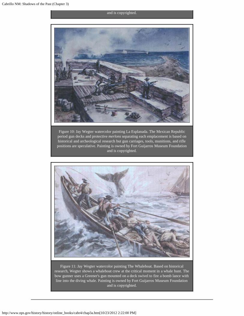
Cabrillo NM: Shadows of the Past (Chapter 3)
http://www.nps.gov/history/history/online_books/cabr4/chap3a.htm[10/23/2012 2:22:00 PM]
and is copyrighted.
Figure 10: Jay Wegter watercolor painting La Esplanada. The Mexican Republicperiod gun decks and protective merlons separating each emplacement is based onhistorical and archeological research but gun carriages, tools, munitions, and riflepositions are speculative. Painting is owned by Fort Guijarros Museum Foundation
and is copyrighted.
Figure 11: Jay Wegter watercolor painting The Whaleboat. Based on historicalresearch, Wegter shows a whaleboat crew at the critical moment in a whale hunt. Thebow gunner uses a Greener's gun mounted on a deck swivel to fire a bomb lance withline into the diving whale. Painting is owned by Fort Guijarros Museum Foundation
and is copyrighted.

Cabrillo NM: Shadows of the Past (Chapter 3)
http://www.nps.gov/history/history/online_books/cabr4/chap3a.htm[10/23/2012 2:22:00 PM]
<<< Previous <<< Contents >>> Next >>>
cabr/shadows/chap3a.htmLast Updated: 06-Apr-2005
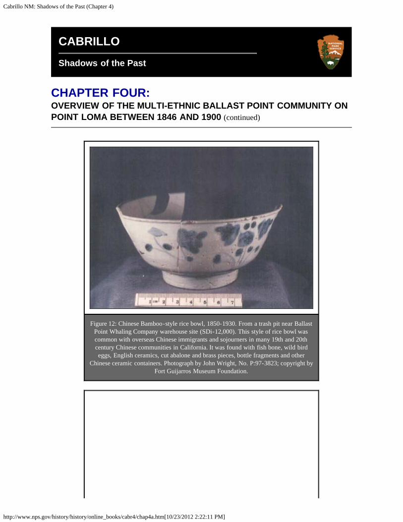
Cabrillo NM: Shadows of the Past (Chapter 4)
http://www.nps.gov/history/history/online_books/cabr4/chap4a.htm[10/23/2012 2:22:11 PM]
CABRILLO
Shadows of the Past
CHAPTER FOUR:OVERVIEW OF THE MULTI-ETHNIC BALLAST POINT COMMUNITY ONPOINT LOMA BETWEEN 1846 AND 1900 (continued)
Figure 12: Chinese Bamboo-style rice bowl, 1850-1930. From a trash pit near BallastPoint Whaling Company warehouse site (SDi-12,000). This style of rice bowl wascommon with overseas Chinese immigrants and sojourners in many 19th and 20thcentury Chinese communities in California. It was found with fish bone, wild birdeggs, English ceramics, cut abalone and brass pieces, bottle fragments and other
Chinese ceramic containers. Photograph by John Wright, No. P:97-3823; copyright byFort Guijarros Museum Foundation.

Cabrillo NM: Shadows of the Past (Chapter 4)
http://www.nps.gov/history/history/online_books/cabr4/chap4a.htm[10/23/2012 2:22:11 PM]
Figure 13: Chinese Double Happiness-style bowl, 1850-1870. Recovered in sametrash pit as bowl in Figure 12. Photography by John Wright, No. P:96-3506;
copyright by Fort Guijarros Museum Foundation.
Figure 14: Saw-cut Abalone shell from Chinese fishing campsite, SDi-12,953. Shellblanks were fashioned into jewelry, furniture inlay, and fishing lures. Although noted
in historical literature, these specimens are the first recovered examples of Chinesecut-shell crafts on the Pacific Coast. Also associated with these rejected saw-cut
pieces were clamshells, domesticated food animal bone, Asian and Chinese ceramics,and liquor bottle fragments. Photography by John Wright, No. P-98-5491. Copyright
by Fort Guijarros Museum Foundation.

Cabrillo NM: Shadows of the Past (Chapter 4)
http://www.nps.gov/history/history/online_books/cabr4/chap4a.htm[10/23/2012 2:22:11 PM]
Figure 15: Detonated bomb lance harpoon recovered from trash pit near site SDi-12,593, the 1860-1870s Ballast Point Whaling Company warehouse. This artifact wasassociated with white table ceramics from England, glass mustard bottle fragments,wine and whiskey bottle pieces, and a few Chinese bowl pieces from 1850-1860s.
Photography by John Wright, No. P:97-4101. Copyright by Fort Guijarros MuseumFoundation.
Figure 16: Glazed, red clay smoking pipe George Washington, President style, 1850-1885. Recovered from site SDi-12,000, Ballast Point Whaling Station, which covered
the previous ruins of Fort Guijarros. Photograph No. P:96-3383 by John Wright.Copyright by Fort Guijarros Museum Foundation.

Cabrillo NM: Shadows of the Past (Chapter 4)
http://www.nps.gov/history/history/online_books/cabr4/chap4a.htm[10/23/2012 2:22:11 PM]
Figure 17: Spanish Majolica sherd, Aranama Tradition. Dates to post-1790 to pre-1835. Found in water-logged, anaerobic clay bog deposit behind a wall of Fort
Guijarros. Photograph by John Wright, No. P:96-3581. Copyright by Fort GuijarrosMuseum Foundation.
<<< Previous <<< Contents >>> Next >>>
cabr/shadows/chap4a.htmLast Updated: 06-Apr-2005
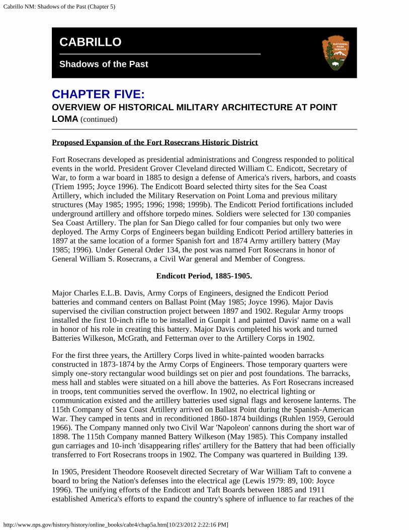
Cabrillo NM: Shadows of the Past (Chapter 5)
http://www.nps.gov/history/history/online_books/cabr4/chap5a.htm[10/23/2012 2:22:16 PM]
CABRILLO
Shadows of the Past
CHAPTER FIVE:OVERVIEW OF HISTORICAL MILITARY ARCHITECTURE AT POINTLOMA (continued)
Proposed Expansion of the Fort Rosecrans Historic District
Fort Rosecrans developed as presidential administrations and Congress responded to politicalevents in the world. President Grover Cleveland directed William C. Endicott, Secretary ofWar, to form a war board in 1885 to design a defense of America's rivers, harbors, and coasts(Triem 1995; Joyce 1996). The Endicott Board selected thirty sites for the Sea CoastArtillery, which included the Military Reservation on Point Loma and previous militarystructures (May 1985; 1995; 1996; 1998; 1999b). The Endicott Period fortifications includedunderground artillery and offshore torpedo mines. Soldiers were selected for 130 companiesSea Coast Artillery. The plan for San Diego called for four companies but only two weredeployed. The Army Corps of Engineers began building Endicott Period artillery batteries in1897 at the same location of a former Spanish fort and 1874 Army artillery battery (May1985; 1996). Under General Order 134, the post was named Fort Rosecrans in honor ofGeneral William S. Rosecrans, a Civil War general and Member of Congress.
Endicott Period, 1885-1905.
Major Charles E.L.B. Davis, Army Corps of Engineers, designed the Endicott Periodbatteries and command centers on Ballast Point (May 1985; Joyce 1996). Major Davissupervised the civilian construction project between 1897 and 1902. Regular Army troopsinstalled the first 10-inch rifle to be installed in Gunpit 1 and painted Davis' name on a wallin honor of his role in creating this battery. Major Davis completed his work and turnedBatteries Wilkeson, McGrath, and Fetterman over to the Artillery Corps in 1902.
For the first three years, the Artillery Corps lived in white-painted wooden barracksconstructed in 1873-1874 by the Army Corps of Engineers. Those temporary quarters weresimply one-story rectangular wood buildings set on pier and post foundations. The barracks,mess hall and stables were situated on a hill above the batteries. As Fort Rosecrans increasedin troops, tent communities served the overflow. In 1902, no electrical lighting orcommunication existed and the artillery batteries used signal flags and kerosene lanterns. The115th Company of Sea Coast Artillery arrived on Ballast Point during the Spanish-AmericanWar. They camped in tents and in reconditioned 1860-1874 buildings (Ruhlen 1959, Gerould1966). The Company manned only two Civil War 'Napoleon' cannons during the short war of1898. The 115th Company manned Battery Wilkeson (May 1985). This Company installedgun carriages and 10-inch 'disappearing rifles' artillery for the Battery that had been officiallytransferred to Fort Rosecrans troops in 1902. The Company was quartered in Building 139.
In 1905, President Theodore Roosevelt directed Secretary of War William Taft to convene aboard to bring the Nation's defenses into the electrical age (Lewis 1979: 89, 100: Joyce1996). The unifying efforts of the Endicott and Taft Boards between 1885 and 1911established America's efforts to expand the country's sphere of influence to far reaches of the
Cabrillo NM: Shadows of the Past (Chapter 5)
http://www.nps.gov/history/history/online_books/cabr4/chap5a.htm[10/23/2012 2:22:16 PM]
world. The resulting underground batteries and infrastructure constructed at Fort Rosecransare witnesses to these important historic global contexts of America's development as asuperpower.
Roosevelt and the Taft Board streamlined America with elaborate coal-fired steam electricalgenerating plants which powered communications, lighting, and mechanical systems. Amongthe many important achievements represented at Fort Rosecrans is the 1906 Naval RadioStation, which linked to a transcontinental network in 1917. To achieve this new age, the TaftBoard directed the Secretary of the Navy to expand the Navy Coaling Yard to fuel the PacificCoast fleet.
The following properties are recommended as eligible for inclusion on the National Registerunder Criteria A because they have the potential to contribute to our understanding ofPresident Grover Cleveland's administration and the Endicott Board's role in the developmentof America's national defense policy:
Building 174: Army Battery Wilkeson, 1897-1898. Cast Concrete. H-27B. Naval BasePoint Loma. Determined eligible by the SHPO and listed in the SUBASE HARP Plan forinclusion on the National Register. Portions lay on top of the 1796-1835 Spanish andMexican Fort Guijarros artillery battery, barracks, kitchen, casemate and flagpole at CA SDI-12000. Vertical soil stratigraphy exposed in 1984 archaeology excavations showed Europeanmaritime whaling station residential deposits sandwiched between the lower Spanish andupper Battery Wilkeson. Testing of the top of a graded slope north of Battery Wilkeson in1999 revealed an intact portion of prehistoric site CA-SDi-12,000. This property may also beeligible under Criteria B for its association with Major Charles E.L.B. Davis and Criteria Cbecause Endicott Period batteries represent a significant and distinguishable entity whosecomponents may lack individual distinction. It is the oldest standing military structure and theonly Endicott Period 10-inch rifled gun battery in San Diego.
Building 256, Battery McGrath, 1899. Cast Concrete. H-27D. Naval Base Point Loma.Determined eligible by the SHPO for inclusion on the National Register and was included inthe HARP Plan. Army Corps of Engineers Completion Reports from 1898 and 1899 reportedMexican Period adobe and concrete construction in the soil. The soils surrounding thisbattery contain portions of prehistoric site CA-SDi-48. This property may also be eligibleunder Criteria B for its association with Major Charles E.L.B. Davis, and Criteria C becauseEndicott Period batteries represent a significant and distinguishable entity whose componentsmay lack individual distinction.
(gone) Battery Fetterman, 1900. Cast concrete. H-27C. Naval Base Point Loma.Recommended ineligible for inclusion on the National Register because it no longer existsabove ground. This issue needs to be revisited because the foundations were observed duringroad construction in 1987 and the ruins may qualify under Criteria D for their potential tocontribute to scientific research. Concrete street and asphalt paving cover European whalingevidence and Army portions of CA-SDi-12,000, as revealed in electrical and storm drainutility line excavation.
Searchlight #1, 1902. Cast Concrete. H-27E. Naval Base Point Loma. Recommendedeligible for inclusion on the National Register of Historic Properties under Criteria A and theassociated archaeological trash dump needs testing to determine eligibility under Criteria D.Soil surrounding the structure may contain historic archaeology features.
(gone) Electrified Industrial Systems, 1904-1911. Fire Control systems: expansion of theMining Casemate, Torpedo Houses, Cable Tanks, Power House, Engineer's House.Construction of Jones Hall in 1990 destroyed most of these features, but a portion of the
Cabrillo NM: Shadows of the Past (Chapter 5)
http://www.nps.gov/history/history/online_books/cabr4/chap5a.htm[10/23/2012 2:22:16 PM]
1908 igloo vaulted access tunnel to the 1898 Mining Casemate remains buried. Portions ofprehistoric site CA-SDi-12,000 survives.
Searchlight, Power House, and Radar, 1909. Cast concrete and brick. Space and NavalWarfare property. Recommended eligible for inclusion on the National Register. (See H 18 inthe proposed expansion of the Fort Rosecrans Historic District). Soil surrounding thestructure contains historic archaeology.
Electrical Connection Box, 09HS-4, 1909. Cast concrete with an aluminum box marked,"1909 Engineers Department, U.S. Army, Colin Electrical Company, New York." The Armymodified this structure, as marked "U.S. Army 1941, U.S.A." This is located on the east sideof Point Loma within Cabrillo National Monument.
Post Taft Board Period, 1912-1914
Following the Roosevelt Administration, the Progressive Party became the driving politicalforce of the times. Civic leaders promoted nationalism through public projects, such asCabrillo National Monument, the 1915 World Exposition in Balboa Park and designation ofCabrillo National Monument within Fort Rosecrans (May 1999a).
Building 170, Militia Building, 1911. Brick. Building 170, Naval Base Point Loma. Thiscivilian structure needs an eligibility determination as sole representative structure from thePost Taft Board Peace Time. Steel hardware from windows, doors, and the roof structurelitter the soil on the south and east sides. Asphalt covers portions of prehistoric site CA-SDi-48.
War in Europe and American Response
The outbreak of war in Europe in 1914 stimulated Congress to fund the Department of Warfor improvements to the Sea Coast Defense of America (Joyce 1996). The War Departmentordered two mortar batteries, fire control stations, and searchlights to be built on Point Lomabetween 1915-1916 (Ruhlen 1959:64). The mortars were capable of firing over the spine ofPoint Loma to hit offshore naval shipping.
The following properties are recommended eligible for inclusion on the National Registerunder Criteria A because they contribute to our understanding of the processes of America'sresponse to the war in Europe in the period following 1914 and Congressional declaration ofwar:
Building 100, Battery John White 1916. Cast concrete. Naval Base Point Loma.Recommended eligible for inclusion on the National Register under Criteria A. Soil andgullies surrounding Battery White contain deposits of historic archaeology associated withthe structure. The original searchlights at the south battery were restored by the Navy in 1999.Battery White may also qualify under Criteria C because Endicott Period batteries embodythe distinctive characteristics of a type, period, or method of construction that represent asignificant and distinguishable entity whose components may lack individual distinction.
Battery Whistler, 1916. Cast concrete. Space and Naval Warfare facility. Recommendedeligible for inclusion on the National Register under Criteria A and in the process ofHABS/HAER documentation.
Battery Command Station for Batteries White and Whistler, 1916; Base End Station forBattery Ashburn, 1943. Cast concrete. H-10, Space and Naval Warfare facility.Recommended eligible for inclusion on the National Register under Criteria A.

Cabrillo NM: Shadows of the Past (Chapter 5)
http://www.nps.gov/history/history/online_books/cabr4/chap5a.htm[10/23/2012 2:22:16 PM]
Base End Station for Batteries White and Whistler, 1916; Battery Command Station forBatteries Zeilen and Woodward, 1943. Cast concrete. H-10, Space and Naval Warfarefacility. Recommended eligible for inclusion on the National Register under Criteria A.
Fire Commander's Station, 1916; Battalion and Harbor Stand-by Command Post, 1941.Cast concrete. H-8, Space and Naval Warfare facility. Recommended eligible for inclusionon the National Register under Criteria A.
Fire Commander's Station, 1916; Battalion and Harbor Stand-by Command Post, 1942.H-10, Space and Naval Warfare facility. Recommended eligible for inclusion on the NationalRegister under Criteria A.
Fire Commander's Station, 1916; Base End Station for Battery Strong, 1941. H-21A,Space and Naval Warfare facility. Recommended eligible for inclusion on the NationalRegister under Criteria A.
Base End Station and Battery Command Station for Batteries White and Whistler,1916. H-22, Space and Naval Warfare facility. Recommended eligible for inclusion on theNational Register under Criteria A.
Searchlight #1, 1916; Searchlight #11, 1941. H-5. Cast concrete, Space and Naval Warfarefacility. Recommended eligible for inclusion on the National Register under Criteria A.
Searchlight #4, 1916. Wood frame, Space and Naval Warfare facility. Recommendedeligible for inclusion on the National Register under Criteria A.
Power House for Searchlights 1 and 2, 1916/ Radar Unit S.C.R., 1942. Cast concrete. H-18. Building 15C, Space and Naval Warfare facility. Recommended eligible for inclusion onthe National Register of Historic Properties under Criterion A.
Fire Commander's Station (Batteries White and Whistler) 1916. Cast concrete with steelshielding. Space and Naval Warfare facility. Recommended eligible for inclusion on theNational Register under Criteria A.
Fort Commander's Station (Batteries Wilkeson, Fetterman, McGrath, White andWhistler), 1916. Cast concrete. Located at Space and Naval Warfare facility. Recommendedeligible for inclusion on the National Register under Criteria A.
Base End and Battery Command Station, 1916-1924. Cast concrete. H-22. Space andNaval Warfare facility. Recommended eligible for inclusion on the National Register underCriteria A.
Signal Station, 1916. Cast concrete. H-23. Space and Naval Warfare facility. Recommendedeligible for inclusion on the National Register under Criteria A.
Plank Walkway, 1916. Wood frame. H-30. Naval Supply Center. This structure needs to beevaluated for contributing value to the Fort Rosecrans Historic District. A carefulexamination of the dense brush surrounding the feature has not been conducted to determineif historic archaeology exists.
War in Europe, World War I and the Great Influenza Epidemic, 1917-1919
American entry into the war in Europe triggered one of the Nation's largest military buildupsin history (Joyce 1996). Emergency War Act funds in 1917 fueled massive constructionprojects at Fort Rosecrans to house 21,000 soldiers, officers, and support personnel (May

Cabrillo NM: Shadows of the Past (Chapter 5)
http://www.nps.gov/history/history/online_books/cabr4/chap5a.htm[10/23/2012 2:22:16 PM]
1999a). Entire neighborhoods of barracks were constructed in the first 90 days, as FortRosecrans expanded far beyond the Colonial Revival buildings along Sylvester Street.Lumber stripped from older military bases was reused in these structures. All areas of theMilitary Reservation were used during World War I.
The following properties are recommended as eligible for inclusion under Criteria A becausethey are associated with America's role in World War I and response to the Great InfluenzaEpidemic during the period between 1917 and 1919:
(gone) Temporary Cantonments; Ballast Point, Middle, and Upper, 1918. (demolished by1934). The 1974 Navy enlisted barracks, Rosecrans Street, and White Road have impactedportions of prehistoric site CA-SDi-48 and historic archaeology associated with thiscantonment.
Building 138, YMCA Service Club, 1919. Wood frame, Craftsman Bungalow Style, NavalBase Point Loma. Determined by the SHPO to be a contributing element to the FortRosecrans Historic District. Lawns and the back alley cover portions of prehistoric site CA-SDi-48 and historic archaeology.
(gone) Hospital Steward's Quarters, 1904 and 1917. Brush covered gullies and thenorthern fill slope contains historic archaeology deposits, architectural remains, andcobblestone drains associated with this structure. These have not been examined or evaluatedfor National Register value.
(gone) Hospital Storehouses, 1918. Cuts in uphill terrain on the west show broken purpleglass, white ware ceramics and the potential for buried historic archaeology in thesurrounding soils. The alley on the east contains portions of prehistoric site CA-SDi-48.
Knights of Columbus Building, 1918. Building 215, Naval Base Point Loma. (Buildings122 and 71 on older maps). Determined by the SHPO not to be a contributing element to theFort Rosecrans Historic District, this structure was totally rebuilt in 1998. The lawns containportions of CA-SDi-48, as evidenced by rock-packed fire hearths and portable metatefragments exposed in sprinkler trenches in 1999.
(gone) Building 110, Club Chef's Quarters, ca. 1920. Naval Base Point Loma. Asphaltcovers portions of prehistoric site CA-SDi-48 and historic archaeology.
Radio Station, 03HS-2, 1917. Concrete. This radio station once included two towers, whichare now gone. During World War II, radio operations expanded and relocated to the HarborDefense Command Post and this building became a meteorological station for the ArmyCoast Artillery. This is in the Cabrillo National Monument Historic District and now housespublic exhibits regarding the coastal defense systems.
Searchlight Shelter, 09HS-5; Generator Plant, 09HS-6; and Searchlight Shelter, 09HS-7, 1918-1919. Cast concrete. This partially dug-in structure contained a 60-inch searchlightmounted on narrow gage rails and covered with a wooden door. Originally named "No. 5," itwas renumbered "No. 11" and then "No. 18" in 1942. This is within the Cabrillo NationalMonument Historic District. This includes the generator plant (09HS-6) and the shelter(09HS-7).
Fire Control Stations 09HS-8, 9, and 10, 1918-1920. Cast concrete. Three partiallyunderground bunkers with steel shutter-covered windows served as observation posts totriangulate artillery plotting. The surface of these structures originally had sandbaggedbunkers, wire netting, natural rock and earth heaped on top to camouflage these features fromenemy naval observation. This is within the Cabrillo National Monument Historic District.

Cabrillo NM: Shadows of the Past (Chapter 5)
http://www.nps.gov/history/history/online_books/cabr4/chap5a.htm[10/23/2012 2:22:16 PM]
These serviced Batteries Calef-Wilkeson and are in preserved condition. Window glassfragments and shaped wooden pieces from WWII use are visible on slopes near thesestructures.
Meyler Road, 1918-1919. Graded dirt road connecting Searchlights 5 and 6, power plant andBilly Goat Point. Renamed "Bayside Trail" by the Park Service, it now serves as a walkingtrail. The Army honored the memory of Army Lt. James J. Meyler, Base Engineer, FortRosecrans, who served as the first Base Engineer after Major Charles E.L.B. Davis turnedcommand of Fort Rosecrans to the regular army. Lt. Meyler died on duty at Fort Rosecrans.An abandoned portion of this road parallels the modern roadway at a lower elevationcontour.
Interwar Period, 1922-1935
America believed the political myth that World War I was "the war to end all wars" in theperiod following Armistice (Joyce 1996). The political sentiment towards internal recoveryand rebuilding America's economy led to a period of isolationism. The public entrusted theLeague of Nations to reconstruct Europe. Citizens returned to their farms and factories. TheWashington Naval Treaty of 1922 resulted in mothballing thousands of naval ships andclosure of military bases across the Nation. Fort Rosecrans closed to caretaker status in 1924,when the 115th and 28th Companies of Coast Artillery shipped out to Puget Sound,Washington (Ruhlen 1959; Flower, Ike and Roth 1982; May 199a).
Civilian caretakers maintained Fort Rosecrans with locked buildings and minor repair workin the years following 1924 (Gerould 1966). National Guard units used the fort for training.This included 6th Infantry HQ Brigade who occupied the 1904 Administration Building in1928. One year later, the 11th Cavalry moved from Camp Hearn in Imperial Beach to jointhem (May 1999a). These units created the anti-aircraft Batteries Gillespie and Point Loma in1930. They trucked in 155 mm. Howitzer rifles to remote posts on the western cliffs that nolonger exist near the 1891 Lighthouse.
The cost of maintaining American military posts became an isolationist issue. Congressionalhearings of base and post closure met with stiff resistance from veterans and politicalscientists concerned about new movements in Europe. Congressman Phil Swing of San Diegowent on record opposing closure of Fort Rosecrans (Union 5/25/1931). The 1933 Germaninvasion of Poland heralded the end of isolationism and Congress began to reassessAmerican defense capability. There are no Army properties from this historic context ( SeeNavy Supply Center and Fuel Depot for representation).
War in Europe and The War Preparedness Act of 1935
The Nazi Blitzkrieg across Europe caused world powers to reconsider their safety (Joyce1996). In the contest of wills between isolationists, nationalists, and war veterans, Congressvoted to rebuild American military defense capability under the rubric of recovery from theGreat Depression. In 1935 Congress directed the Army Corps of Engineers to dredge SanDiego Harbor to handle larger ships (May 1999a). That same year, six Japanese spies werecaught with notebooks, maps, and photographs of military installations, which further fueledpublic insistence for a stronger military presence (San Diego Daily News, 3/7/35). NationalGuard troops restored the artillery at Batteries Wilkeson, Fetterman, McGrath, White, andWhistler. Test firings of these artillery positions for the House Appropriations Committee in1936 resulted in recommendations for funding to modernize Fort Rosecrans (San DiegoUnion, 7/23/36).
The following year, the Department of War implemented new artillery systems throughoutthe nation. Fort Rosecrans played a major role in this historic decision to rearm America.

Cabrillo NM: Shadows of the Past (Chapter 5)
http://www.nps.gov/history/history/online_books/cabr4/chap5a.htm[10/23/2012 2:22:16 PM]
The following properties are recommended for inclusion on the National Register becausethey are associated with America's recovery from the Great Depression and make acontribution toward our understanding of revitalization for military infrastructure in PresidentFranklin D. Roosevelt's administration.
Battery Gillespie, 1930-1936. Cast concrete. Space and Naval Warfare facility.Recommended eligible for inclusion on the National Register under Criteria A and mayqualify under Criteria A. The soil at this site contains underground sandbagged trenches,wooden bunkers, kitchens and barracks and other historic archaeological resources coveredby the Navy for safety purposes.
Battery Gillespie Base End Station, 1936. Temporary wood frame. H-4, Space and NavalWarfare facility. Recommended eligible for inclusion on the National Register under CriteriaA. The soil at this site contains underground sandbagged trenches, wooden bunkers, kitchensand barracks and other historic archaeological resources covered by the Navy for safetypurposes.
Battery Strong, 1937. Building 397, Space and Naval Warfare facility. Cast concrete.Recommended eligible for inclusion on the National Register under Criteria A. The soil atthis site contains underground sandbagged trenches, wooden bunkers, kitchens and barracksand other historic archaeological resources covered by the Navy for safety purposes. South ofBattery Strong, portions of sandbagged trenches and two cast concrete bunker entrancesindicate the surrounding area is honeycombed with historic features.
Battery Strong Base End Station, 1937. Cast concrete. H-9, Space and Naval Warfarefacility. Recommended eligible for inclusion on the National Register under Criteria A. Thesoil at this site contains underground sandbagged trenches, wooden bunkers, kitchens andbarracks and other historic archaeological resources covered by the Navy for safety purposes.
When news reached the United States that France had fallen to the German invasion andBritish soldiers were streaming out of France on an immense armada of civilian and militarytransports, the western powers abandoned all pretense of isolationism. Congress acceleratedmilitary spending to prepare to fight the anticipated European invasion, as Canadian troops tothe north shipped out to support the British military (May 1999a).
By the fall of 1940, there were 21,000 soldiers at Fort Rosecrans (San Diego Union,10/17/40). To accommodate this massive build up, new cantonments were built at BallastPoint and at the old Upper Cantonment between the Post Cemetery and Radio Point Loma(May 1999a).
World War II, 1941-1945.
Fort Rosecrans expanded dramatically during World War II from the Endicott and TaftPeriod Army Post concentrated on the eastern side of Point Loma (Flower, Ike and Roth1982). All of the 1852 Military Reservation on Point Loma became the staging area foradvanced anti-naval coastal artillery and anti-aircraft batteries (Joyce 1996). Complexelectrical and communications systems linked sighting base end stations and communicationscommand centers with artillery batteries. Fort Rosecrans continued to service and staff theolder obsolete Endicott and Taft Period batteries until replacements became available in 1942and 1943. By that point in time, the Army soldiers changed uniforms, personal weapons, andliving accommodations to form the new Coast Artillery Corps (May 1999a). In truth, FortRosecrans linked with extended units beyond Point Loma as east as Otay Mountain, NorthIsland, and Camp Callan to the north. Within the World War II defense scheme, distinctcommunities were isolated and functionally insular from one another.

Cabrillo NM: Shadows of the Past (Chapter 5)
http://www.nps.gov/history/history/online_books/cabr4/chap5a.htm[10/23/2012 2:22:16 PM]
Since the original 28th and 115th Companies of Coast Artillery departed Fort Rosecrans in1924 to Puget Sound, Washington, new Army units formed between 1935 and 1942 (May1999a). The 262nd and 281 Coast Artillery Battalions formed the Fort Rosecrans units thatmet World War II emergencies. These soldiers of the 1930s and 1940s were entirely differentthan the earlier troops, as indicated by their uniforms and reason for being there. The soldiersof World War II Fort Rosecrans were largely drafted from the Mid West and East Coast tofight the war in the Pacific Theater or Europe. These were not professional soldiers, butpeople motivated to achieve an immediate objective.
Dredging operations to deepen San Diego Bay in 1940 provided the Army Corps ofEngineers with material to fill in half the inlet north of Ballast Point to form a new buildingpad (Turhollow 1975). The fill allowed the Quartermaster Corps to extend Rosecrans Streetsouth of the Naval Fuel Depot to terminate at new warehouses at Ballast Point. The 1940building pad supported a cantonment of barracks, mess halls, and support facilities built in1942.
Congress authorized the Department of War to rebuild America's defenses in 1935(Turhollow 1975; Floyd 1985). The Army Quartermaster Corps worked with civiliancontractors and the Works Progress Administration to carry out this Congressional mission(May 1999a).
Emergency Defense Batteries, 1941-1945. Immediately following the Japanese attack onPearl Harbor on December 7, 1941, emergency defense batteries were installed along thePacific Coast to ward off aircraft attack. Examples of those batteries exist on Point Loma(Flower, Ike and Roth 1982). With one exception, careful archaeological examination ofthese features has not been conducted, but .30-06 shell casings and historic glass indicatesthat soils contain historic archaeology features.
The following properties are recommended as eligible for inclusion on the National Registerbecause they represent America's immediate emergency response to the bombing of PearlHarbor in the days following that pivotal event in American history:
WW II 30 Caliber Machine Gun Emplacements, 1941. H-3, Space and Naval Warfarefacility. CA-SDi-13749H and CA-SDi-13750H. Recommended eligible for inclusion on theNational Register under Criteria A because of their role in the defense of Fort Rosecransfrom potential aerial assault. The soil at this site contains underground sandbagged trenchesand wooden bunkers and other historic archaeology that have been covered by the Navy forsafety purposes.
Three underground wooden framed 30-caliber machine gun emplacements were installed onthe upper western slope of Point Loma at the northern end of Space and Naval Warfarefacility. Two are spaced 100-feet apart and the other is located 300-feet west. Theseemplacements are wooden rooms with wood floors with stairs that lead to a 2-bunk sleepingquarters. Earth covers the roofs and one has completely collapsed.
Battery Strong Latrine, 1941. Wood frame. Building 401, Space and Naval Warfarefacility. Recommended eligible for inclusion on the National Register under Criteria A. Thesoil at this site contains underground sandbagged trenches, wooden bunkers, kitchens andbarracks and other historic archaeology that have been covered by the Navy.
Battery Strong Plotting Room and Power House, 1942. Building 549, Space and NavalWarfare facility. Recommended eligible for inclusion on the National Register under CriteriaA. The soil at this site contains underground sandbagged trenches, wooden bunkers and otherhistoric archaeology covered by the Navy.
Cabrillo NM: Shadows of the Past (Chapter 5)
http://www.nps.gov/history/history/online_books/cabr4/chap5a.htm[10/23/2012 2:22:16 PM]
Underground Bunker, 1941-1945. Space and Naval Warfare facility. Recommendedeligible for inclusion on the National Register under Criteria A because it contributes to ourunderstanding of America's early response to defending the Pacific Coast. A canyon uphillmay contain historic archaeological resources.
Ground Attack Defenses, 1941-1945. Wood post and chain link boundary fence and barbedwire. Recommended eligible for inclusion on the National Register under Criteria A becauseit contributes to our understanding of America's early response to defending the Pacific Coastin World War II.
Searchlight Shelter, 05HS-15, and Generator Station 05HS-16, 1942. Cast concrete. Thisunderground structure has a sliding sheet steel door that has been sealed and the GeneratorStation has an inclined walkway that has been filled-in with dirt. It is similar to 09HS-7. It iswithin the Cabrillo National Monument Historic District.
Battery Bluff, 09HS-11, 1942. Cast concrete. Two emplacements of 37-mm artillery weremounted at the entrance of San Diego Harbor to protect against motor torpedo boats. This islocated within the Cabrillo National Monument Historic District. Oral history existsregarding construction and operation of this battery. Historical archeological resourcesinclude gun emplacements, a dug-out feature, a few surface artifacts and an isolated butdeteriorating wooden plank reserve munitions storage box.
Battery Point Loma, 05HS-14, 1939-1941. Cast concrete and steel rail. Four 155-mm.artillery guns were hauled by tractor to be installed in mounts that are 90 feet apart. Three arecovered with dirt, but one is exposed. Each mount has a steel circular rail that has a 38.5-footdiameter. Sandbagged communications trenches link the rear of the emplacements. Threepartially underground igloo bunkers contain the remains of wood and wire bunk beds. Onewas dynamited and some of the trenches bulldozed in 1966, as observed by Ronald V. May.These are located with the Cabrillo National Monument Historic District. One gun ring hasbeen documented through archeological excavations and oral history exists regarding theoperation of this battery (Jones and Overton 1984). It is recorded as archeological site CA-SDi-11,936H and meets Criteria D as well as others.
Magazine, 05HS-17, 1942-1943. Cast concrete. This igloo-style magazine is identical to the1942 Hospital Morgue Annex, uphill and west of the 1940 Hospital Annex along SylvesterRoad. Interior wooden shelves are bolted to the floor. It is located within the CabrilloNational Monument Historic District.
The following properties are recommended as eligible for inclusion on the National Registerbecause they are associated with America's role in World War II and can contribute to ourunderstanding of this important period of history:
Buildings 210-212, Nurses Quarters, Lower Cantonment, 1942. Wood frame. Naval BasePoint Loma. Recommended for inclusion on the National Register of Historic Propertiesunder Criteria A, because they contribute to our understanding of the World War II PostHospital in the Fort Rosecrans Historic District. These buildings were built on 1940 water-landfills and do not likely to cover historic archaeology.
Battery Cabrillo, 1942. Located in two places within the Space and Naval Warfare facilitynear Battery Strong and at a lower elevation. Each emplacement was armed with 90mm anti-motor torpedo boat (AMTB) fixed and mobile guns. Recommended for inclusion on theNational Register of Historic Places under Criteria A because they reflect emergency coastaldefense measures.

Cabrillo NM: Shadows of the Past (Chapter 5)
http://www.nps.gov/history/history/online_books/cabr4/chap5a.htm[10/23/2012 2:22:16 PM]
Battery Command Station for Battery Cabrillo, 1941-1945. Cast concrete. H-21B. Spaceand Naval Warfare facility. Recommended eligible for inclusion on the National Registerunder Criteria A because it contributes to our understanding of the sighting infrastructurenecessary for gunnery calibration systems.
Base End Station for Battery Cabrillo, 1942. Cast concrete. Space and Naval Warfarefacility. Recommended for inclusion on the National Register of Historic Properties underCriteria A because it contributes to our understanding of the sighting infrastructure necessaryfor gunnery calibration systems.
Battery Cliff (1916 Searchlight #4) 1942. Cast concrete. Space and Naval Warfare facility.Recommended for inclusion on the National Register of Historic Properties under Criteria Abecause it contributes to our understanding of nighttime sighting infrastructure necessary fordefensive action.
(gone) Battery Fetterman and Fire Control Structures, 1943. Cast concrete. H-28B.Ineligible for inclusion on the National Register. The asphalt parking lot south and north ofCoast Guard Search and Rescue Station cover portions of the Euro-American and Chinesefishing camp at the 1858-1886 Ballast Point Whaling Station at CA-SDi-12,593. Trenches inthis asphalt revealed cast iron stove parts, cut and burned whale bones, Asian ceramics,butchered domestic livestock bones, 19th century bottle glass, and artifacts associated withthe 1890-1957 Lighthouse. Although the California SHPO determined no National Registervalue to the historic lighthouse in 1988, no evaluation of the historic archaeology has beenreviewed by SHPO staff. Archaeology investigations in 1988, 1989, 1991 and 1992 exposedhistoric archaeology trash deposits, architectural foundations and thousands of artifacts thatare still under analysis by the Fort Guijarros Museum Foundation.
Building F-12, Battery Woodward, 1943. Cast concrete. H-11. Space and Naval Warfarefacility. Recommended eligible for inclusion on the National Register or Historic Propertiesunder Criteria A because it represents a pivotal development in seacoast defense strategy andthe turning point in World War II defense technology. The soil at this site containsunderground sandbagged trenches, wooden bunkers, kitchens and barracks and other historicarchaeology that have been covered by the Navy for safety purposes.
Building F-3, Administration Office, 1942. Wood frame. Space and Naval Warfare facility.Recommended eligible for inclusion on the National Register of Historic Properties underCriteria A because it represents an example of support infrastructure for the Coast Artillery.
Building F-1, Administration Office, 1944. Wood frame. Space and Naval Warfare facility.Recommended eligible for inclusion on the National Register of Historic Properties underCriteria A because it represents an example of support infrastructure for the Coast Artillery.
Buildings F-1, F-6 and F-9, Administration Offices, 1942. Wood frame. Space and NavalWarfare facility. Recommended eligible for inclusion on the National Register of HistoricProperties under Criteria A because it represents an example of support infrastructure for theCoast Artillery.
Harbor Defense Command Post, 1941. Cast concrete. Located at Space and Naval Warfarefacility. Recommended as eligible for inclusion on the National Register under Criteria Abecause it represents the command infrastructure necessary to coordinate targeting andoperation of the Coast Artillery during World War II. The soil at this site containsunderground sandbagged trenches, wooden bunkers, kitchens and barracks and other historicarchaeology that have been covered by the Navy for safety purposes.
Battery Grant, Wood and sandbags. Space and Naval Warfare facility. Battery Grant had

Cabrillo NM: Shadows of the Past (Chapter 5)
http://www.nps.gov/history/history/online_books/cabr4/chap5a.htm[10/23/2012 2:22:16 PM]
two 6-inch guns installed in 1943. Recommended as eligible for inclusion on the NationalRegister under Criteria A because it represents a pivotal development in seacoast defensestrategy and the turning point in World War II. The soil at this site contains undergroundsandbagged trenches, wooden bunkers, kitchens and barracks and other historic archaeologythat have been covered by the Navy for safety purposes.
Building 560, Battery Ashburn, 1943. Cast concrete. Space and Naval Warfare facility.Determined eligible for inclusion on the National Register under Criteria A because itrepresents a pivotal development in seacoast defense of the Pacific Coast and the height ofartillery technology in World War II. It may qualify under Criteria C because it embodiesdistinctive characteristics of World War II artillery construction that represent a significantand distinguishable entity whose components may lack individual distinction. The soil at thissite contains underground sandbagged trenches, wooden bunkers, kitchens and barracks andother historic archaeology that have been covered by the Navy for safety purposes.
Battery Ashburn Plotting Room, 1942. Cast concrete. H-24. Space and Naval Warfarefacility. Determined eligible for inclusion on the National Register under Criteria A because itrepresents a pivotal development in seacoast defense in World War II. The soil at this sitecontains underground sandbagged trenches, wooden bunkers, kitchens and barracks and otherhistoric archaeology that have been covered by the Navy for safety purposes.
Building T-17, Battalion I Command Post World War II, 1941. Cast concrete. H-23.Space and Naval Warfare facility. Recommended for inclusion on the National Register ofHistoric Properties under Criteria A because it represents infrastructure necessary tocoordinate targeting and operation of seacoast artillery in World War II. The soil at this sitecontains underground sandbagged trenches, wooden bunkers, kitchens and barracks and otherhistoric archaeology that have been covered by the Navy for safety purposes.
Building 557, Harbor Defense Command Post, 1941. Cast concrete. Space and NavalWarfare facility. Recommended eligible for inclusion on the National Register under CriteriaA because it represents infrastructure necessary to coordinate targeting and operation ofseacoast artillery in World War II. This site contains underground historic archaeologicalresources covered by the Navy for safety purposes.
Building 547, Battery Humphrey, 1942. Cast concrete. Space and Naval Warfare facility.Determined eligible for inclusion on the National Register under Criteria A because itrepresents a pivotal development in seacoast defense strategy and the height of artillerytechnology in World War II. It also may qualify under Criteria C because it embodiesdistinctive characteristics of World War II artillery construction that represents a significantand distinguishable entity whose components lack individual distinction. No evaluation of thepotential historic archaeology has been undertaken and no report exists addressing this issue.
Building 15, Administrative Office, 1945. Wood frame. Space and Naval Warfare facility.Recommended eligible for inclusion on the National Register of Historic Properties underCriteria A because it represents the support infrastructure for Sea Coast Defense in WorldWar II.
Searchlight #15, 1942. Cast concrete and steel. H-15, Space and Naval Warfare facility.Recommended eligible for inclusion on the National Register under Criteria A because itcontributes to our understanding of artillery sighting infrastructure during World War II. Thissite may contain underground historic archaeological resources.
Water Tank Foundation, 1941-1945. Cast concrete. H-17, Space and Naval Warfarefacility. Recommended eligible for inclusion on the National Register under Criteria Abecause it contributes to our understanding of support infrastructure during World War II.

Cabrillo NM: Shadows of the Past (Chapter 5)
http://www.nps.gov/history/history/online_books/cabr4/chap5a.htm[10/23/2012 2:22:16 PM]
The soil at this site may contain historic archaeological resources.
Conduit Box, 1941-1945. Cast concrete. Space and Naval Warfare facility. Recommendedeligible for inclusion on the National Register under Criteria A because it contributes to ourunderstanding of electrical infrastructure during World War II.
Battery Zeilin, 1942. Space and Naval Warfare facility. Recommended eligible for inclusionon the National Register under Criteria A because it contributes to our understanding of theartillery defense of the Pacific Coast early in World War II. The soil at this site containsunderground historic archaeological resources.
Building 213, Chapel, 1942. Wood frame. Naval Base Point Loma. Recommended forinclusion on the National Register of Historic Properties under Criteria A because itcontributes to our understanding of the morale and welfare of American soldiers duringWorld War II. Portions of this structure were built on 1940 water and landfills, but thewestern portion may cover portions of prehistoric site CA-SDi-48.
Building 112, Ordinance Repair Building, 1943. Wood frame. Naval Base Point Loma.Recommended for inclusion on the National Register of Historic Properties under Criteria Abecause it represents a pivotal development in sea coast defense strategies at the turning pointin World War II, and it represents the height of artillery technology at that time. It alsoqualifies under Criteria C because it represents a significant and distinguishable entity whosecomponents may lack individual distinction. Portions of the asphalt surrounding the structureincludes the Army coal shed foundations and some of prehistoric site CA-SDi-48.
<<< Previous <<< Contents >>> Next >>>
cabr/shadows/chap5a.htmLast Updated: 06-Apr-2005

Cabrillo NM: Shadows of the Past (Chapter 5)
http://www.nps.gov/history/history/online_books/cabr4/chap5e.htm[10/23/2012 2:22:26 PM]
CABRILLO
Shadows of the Past
CHAPTER FIVE:OVERVIEW OF HISTORICAL MILITARY ARCHITECTURE AT POINTLOMA (continued)
Figure 18: Point Loma Military Reservation showing American Army identifiedhistoric resources, including potential archeological deposits, with key to inventorysurveys (Ronald May map). (click on image for an enlargement in a new window)
Key to U.S. Army Era Historic Resources Map

Cabrillo NM: Shadows of the Past (Chapter 5)
http://www.nps.gov/history/history/online_books/cabr4/chap5e.htm[10/23/2012 2:22:26 PM]
MapNumber
NRadNumber
VanWormerNumber
CabrilloNumber Description
1 A-02 H-33 — Naval Radio Station2 E-15 — — Ground Attack Defenses3 E-15 — — Ground Attack Defenses4 — H-01 — Ground Attack Defenses5 E-15 — — Ground Attack Defenses6 D-02 — — Utility Structure7 E-01 — — Ground Attack Defenses8 D-01 H-02 — Battery Gillespie9 D-02 — — Utility Structure
10 D-03 H-04 — Temporary (wooden) Base End Station for BatteryGillespie
11 B-01 H-05 — Searchlight12 B-02 — — Searchlight13 E-03 — — Ground Attack Defenses14 B-03 H-06 — Searchlight and Powerhouse15 E-16 — — Fire Control Structure16 — B-03 — .30-caliber machine gun emplacement17 E-04 — — Battery18 B-07/E-
17/E-18H-08 — Fire Commander's Station in WWI; Battery and
Harbor Command Post in WWII
19 D-06 H-09 — Combined Battery 1 Command and Base EndStation
20 B-06 H-07 — Battery Whistler21 E-06 H-11 — Battery Woodward22 E-05 — — Battery Support23 B-04/B-05 H-10 — Base End Station and Battery Command Station24 D-07 H-12 — Battery Strong25 D-08 — — Fire Control Structure26 D-09 — — Fire Control Structure27 E-19 — — Site Feature28 H-07 — — Site Feature29 E-08 — — Site Feature30 E-08 — — Site Feature31 E-07 — — Site Feature32 E-07 — — Site Feature33 E-20 — — Ground Attack Defenses34 D-10 H-13 — Harbor Defense Command Post35 E-22 — — Ground Attack Defenses36 D-04 — — Searchlight37 D-05 — — Searchlight38 H-09 — — Site Feature

Cabrillo NM: Shadows of the Past (Chapter 5)
http://www.nps.gov/history/history/online_books/cabr4/chap5e.htm[10/23/2012 2:22:26 PM]
39 — H-17 — Unidentified foundation, possible water tanklocation
40 E-23 H-24 — Plotting Room, Battery Ashburn41 H-24 H-14 — Battery Ashburn42 — — 15 Searchlight Shelter43 — — 16 Generator Station44 — H-15 — Searchlight45 — — 12 Fire Control Structure46 — — 13 Fire Control Structure47 E-25 H-23 — Signal Station48 E-26 — — Ground Attack Defenses49 E-11 — — Utility Structure50 — — 17 Magazine51 H-12 — — Battery52 H-13 — — Searchlight53 — — 14 Battery Point Loma54 — E-16 — Point Loma Light House55 H-14 — — Fire Control Structure56 A01 H-18 — Searchlight, Powerhouse, Radar57 E-28 — — BatteryS8 B-11 H-19 — Searchlight; Battery Cliff
59 B-09 H-22 — Base End Station and Battery Commander'sStations
60 E-27 H-20 — Battery Humphrey-Ground Attack Defenses61 B-10/D-11 H-21 — Fort Battery Commander's and Base End Station62 — — 04 Electrical Connection Box63 — — 05 Searchlight Plant64 — — 06 Generator Plant6S — — 11 Battery Bluff66 — — 07 Searchlight Shelter67 — — 03 Fire Control Structure68 — — 02 Radio Transmission Station69 — — 10 Generator Plant70 — — 08 Fire Control Structure71 — — 09 Fire Control Structure72 — H-27E — Searchlight, Historic Dump73 — E-26 — Radio Transmission Station74 — H-27D — Battery McGrath75 — H-25 — Battery John White76 — H-27B — Batteries Gillespie & Wilkeson77 — H-27C — Battery Fetterman78 — H-27F — Mining Casemate
79 — H-28B — AMTB Battery Fetterman and Fire ControlStructure

Cabrillo NM: Shadows of the Past (Chapter 5)
http://www.nps.gov/history/history/online_books/cabr4/chap5e.htm[10/23/2012 2:22:26 PM]
80 — H-29 — Fort Rosecrans Historic District81 H-21 — — Fire Control Structure82 — H-30 — Plank Walkway
83 — — — Fort Rosecrans Historic District non-contiguousstructure
84 — — — Horse Burial
85 — — — Fort Rosecrans Historic District non-contiguousstructure
86 — — — Fort Rosecrans Historic District non-contiguousstructure
87 — H-32 — La Playa-Quarantine Station-Navy Supply Center88 — H-31 — Ground Attack Defenses, Barbed Wire89 A-03 — — Target Repair Base
Figure 19: Insignia of 115th Company, Coast Artillery Corps, uniform collar insigniafrom 1902-1924. This Company manned Battery Wilkeson 10 inch DisappearingRifles and were quartered at Building 139. This artifact was found with burned
uniform supplies discarded upon the refuse of Ballast Point Whaling Company, siteSDi-2,000. Photograph by John Wright, No. P:95-1515. Copyright by Fort Guijarros
Museum Association.

Cabrillo NM: Shadows of the Past (Chapter 5)
http://www.nps.gov/history/history/online_books/cabr4/chap5e.htm[10/23/2012 2:22:26 PM]
Figure 20: 1890 Photograph of Fort San Diego, constructed between 1873-1974. Thewhite buildings housed work crews who improved the roadway sloping upward and
the unfinished artillery battery to the left of the photograph. Photograph taken byLighthouse Service and is not accessioned. Image is property of Fort Guijarros
Museum Foundation.
Figure 21: Ca. 1923 Aerial photograph of 1890 Ballast Point Lighthouse (on top ofKeepers' House), with Assistant Keepers' House, Fog Bell, warehouses of Ballast
Point Whaling Company (barn-like structure and removed warehouse foundations).The open space immediately beyond the existing structures was occupied by 1860-
1870s whaler's oil-rendering tryworks, recorded as archeological site SDi-12,953. Atthe top of this early photograph are four dark barracks at the waters' edge, constructedin 1917 but demolished in 1924. Photograph is not accessioned but image is property
of Fort Guijarros Museum Foundation.
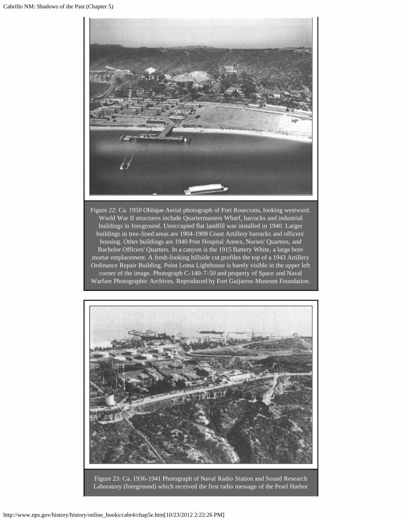
Cabrillo NM: Shadows of the Past (Chapter 5)
http://www.nps.gov/history/history/online_books/cabr4/chap5e.htm[10/23/2012 2:22:26 PM]
Figure 22: Ca. 1950 Oblique Aerial photograph of Fort Rosecrans, looking westward.World War II structures include Quartermasters Wharf, barracks and industrialbuildings in foreground. Unoccupied flat landfill was installed in 1940. Larger
buildings in tree-lined areas are 1904-1908 Coast Artillery barracks and officers'housing. Other buildings are 1940 Post Hospital Annex, Nurses' Quarters, and
Bachelor Officers' Quarters. In a canyon is the 1915 Battery White, a large boremortar emplacement. A fresh-looking hillside cut profiles the top of a 1943 ArtilleryOrdinance Repair Building. Point Loma Lighthouse is barely visible in the upper left
corner of the image. Photograph C-140-7-50 and property of Space and NavalWarfare Photographic Archives. Reproduced by Fort Guijarros Museum Foundation.
Figure 23: Ca. 1936-1941 Photograph of Naval Radio Station and Sound ResearchLaboratory (foreground) which received the first radio message of the Pearl Harbor

Cabrillo NM: Shadows of the Past (Chapter 5)
http://www.nps.gov/history/history/online_books/cabr4/chap5e.htm[10/23/2012 2:22:26 PM]
bombing on December 7, 1941. Looking eastward, round tanks are of the 1917-1940Naval Fuel Depot. Beyond, at shoreline is the Quarantine Station and to the right is
the 1907-1917 Naval Coal Depot which covers the 1822-1880s. La Playa community,including the six British hide houses described by Dana in Two Years Before the
Mast. Copyright and property of Fort Guijarros Museum Foundation.
<<< Previous <<< Contents >>> Next >>>
cabr/shadows/chap5e.htmLast Updated: 06-Apr-2005

Cabrillo NM: Shadows of the Past (Chapter 6)
http://www.nps.gov/history/history/online_books/cabr4/chap6a.htm[10/23/2012 2:22:31 PM]
CABRILLO
Shadows of the Past
CHAPTER SIX:OVERVIEW OF POTENTIAL UNDERWATER ARCHEOLOGY OF POINTLOMA (continued)
Figure 24: Three masted merchant ship Alice McDonald founded on submerged rocksnear 1891 Point Loma Light. Coronado Islands are on the horizon. Photograph taken
December 31, 1909 by San Diego photographer. Image courtesy from San DiegoMaritime Museum, Brennan Collection, No. P2216.
<<< Previous <<< Contents >>>
cabr/shadows/chap6a.htmLast Updated: 06-Apr-2005