Embed Size (px)
Citation preview
C. STRUCTURE
Sout
heas
t Asi
aSt
udy
Type
No
Titl
eTy
pePa
geO
rigi
nal/C
opy
Nos
Publ
ishe
d B
y
1
Doc
umen
tC
opy
1M
PWT
2D
ocum
ent
Cop
y1
MPW
T
3D
ocum
ent
Cop
y1
MPW
T
4D
ocum
ent
Cop
y1
JIC
A C
ambo
dian
Off
ice
5D
ocum
ent
Cop
y1
JIC
A C
ambo
dian
Off
ice
6D
ocum
ent
Cop
y2
Min
istry
of E
cono
my
and
Fina
nce
7
Doc
umen
tC
opy
1U
nite
d N
atio
ns
8
Map
Cop
y1
Uni
ted
Nat
ions
9
Cat
alog
ueC
opy
1U
nite
d N
atio
ns
10
Doc
umen
tC
opy
1JB
IC
Prop
osed
Asi
an H
ighw
ay R
oute
Map
Asi
an H
ighw
ayE
xper
t Gro
up M
eetin
g on
Dev
elop
men
t of t
heA
sian
Hig
hway
Net
wor
k
8-10
May
200
2,B
angk
ok
Are
a
Cou
ntry
Proj
ect
Nam
e
Traf
fic V
olum
e Su
rvey
Res
ult R
epor
t on
NR
6A
Spec
ial A
ssis
tanc
e fo
r Pro
ject
Impl
emen
tatio
n of
the
Siha
nouk
ville
Por
t Urg
ent R
ehab
ilita
tion
Proj
ect
Dra
ft F
inal
Rep
ort
Janu
ary
2002
Cam
bodi
an R
eset
tlem
ent P
olic
y an
d Pr
actic
esR
evie
w a
nd R
ecom
men
datio
ns
The
fesi
bilit
y St
udy
on th
eIm
prov
emen
t of N
atio
nal R
oad
No.
1(P
hnom
Pen
h - N
eak
Loue
ng S
ectio
n)
Term
s of
Ref
eren
ce fo
r Urg
ent R
epai
r of N
o.15
,an
d 17
Brid
ge o
n N
atio
nal R
oad
6A (D
raft)
Apr
il 20
02
Asi
an H
ighw
ay C
atal
ogue
Traf
fic V
olum
e D
ata
in K
ampo
ng C
ham
Nip
pon
Koe
i., L
td
25
Febr
uary
200
2
Con
sulta
ntPC
I & K
EI
Mr.
Ken
ji M
aruo
ka
F/S
MPW
T
Tea
mL
eade
r
Emer
genc
y Fl
ood
Reh
abili
tatio
n Pr
ojec
tB
ridg
e D
esig
n St
anda
rds
Man
ual (
Hyd
raul
icD
esig
n fo
r Flo
od R
ehab
ilita
tion
of R
ural
Roa
ds)
Febr
uary
200
2Se
min
arD
ocum
ent o
n th
e M
axim
um L
oad
Lim
itof
Tra
nspo
rt V
ehic
le T
rafic
king
on
Roa
dN
etw
ork
in th
e K
ingd
om o
f Cam
bodi
a 19
99
Perio
d of
Wor
kin
Cam
bodi
aTh
e K
ingd
om o
fC
ambo
dia
16 S
epte
mbe
r 200
2 - 2
9 N
ovem
ber 2
002
MPW
T
Giv
en B
y
5 M
ay 2
002
- 9 A
ugus
t 200
2
Adv
isor
y C
omm
ittee
JIC
A C
ambo
dian
Off
ice
MPW
T
JIC
A C
ambo
dian
Off
ice
JIC
A C
ambo
dian
Off
ice
Adv
isor
y C
omm
ittee
JIC
A C
ambo
dian
Off
ice
C - 1
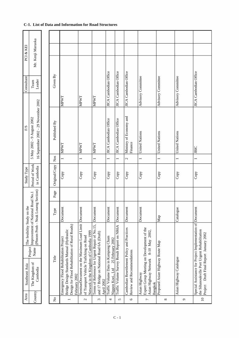
C-1. List of Data and Information for Road Structures
Adv
isor
y C
omm
ittee

No
Title
Type
Page
Orig
inal
/Cop
yN
osPu
blis
hed
By
11D
ocum
ent
Cop
y1
MPW
T
12D
ocum
ent
Cop
y1
MPW
T
13
Doc
umen
tC
opy
1M
PWT
14D
ocum
ent
Cop
y1
MPW
T
15D
ocum
ent
Cop
y1
MPW
T
16
Doc
umen
tC
opy
1M
PWT
Not
e:M
PWT:
Min
istry
of P
ublic
Wor
ks a
nd T
rans
port,
MR
C: M
ekon
g R
iver
Cim
mitt
ee,
AD
B: A
sia
Dev
elop
men
t Ban
k, M
OE:
Min
istry
of E
nviro
nmen
tN
ICFE
C: N
atur
al a
nd Im
peria
l Com
mitt
ee fo
r Fre
e an
d Fa
ir El
ectio
n in
Cam
bodi
a (N
on-g
over
nmen
t Org
aniz
atio
n)
Roa
d D
esig
n St
anda
rd, C
AM
PW
.03.
101.
99,
Min
istry
of P
ublic
Wor
ks a
nd T
rans
port,
199
9
Cam
bodi
an B
ridge
Sta
ndar
ds P
roje
ct, D
raft
Ince
ptio
n R
epor
t, 25
Nov
. 199
8, A
usA
ID
The
Tran
spor
t Mas
ter P
lan
of P
hnom
Pen
hM
etro
polit
an A
rea,
Pro
gres
s Rep
ort,
Nov
.200
0,M
inis
try o
f Pub
lic W
orks
and
Tra
nspo
rt, K
atah
ira&
Eng
inee
rs In
tern
atio
nal
Man
ual f
or A
ssem
bly
and
Erec
tion
of G
irder
Span
s, A
ustra
lian
Age
ncy
for I
nter
natio
nal
Dev
elop
men
t, M
inis
try o
f Pub
lic W
orks
and
199
Man
ual f
or A
ssem
bly
and
Erec
tion
of T
russ
Span
s, A
ustra
lian
Age
ncy
for I
nter
natio
nal
Dev
elop
men
t, M
inis
try o
f Pub
lic W
orks
and
Tt
1996
Brid
ge D
esig
n St
anda
rd, C
AM
PW
.04.
102.
99,
Min
istry
of P
ublic
Wor
ks a
nd T
rans
port,
199
9
Giv
en B
y
C - 2
MPW
T
MPW
T
MPW
T
MPW
T
MPW
T
MPW
T
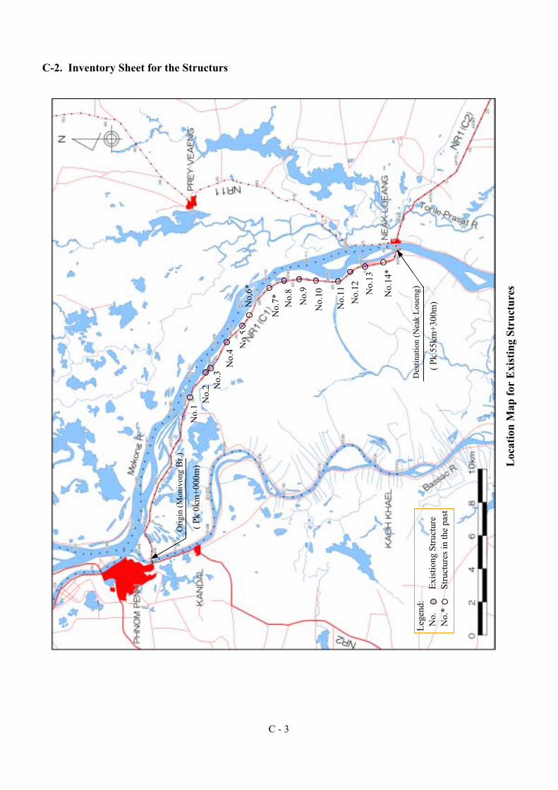
Loc
atio
n M
ap fo
r E
xist
ing
Stru
ctur
es
C-2. Inventory Sheet for the Structurs
C - 3
Lege
nd:
No.
E
xist
iong
Stru
ctur
e N
o.*
Stru
ctur
es in
the
past
No.
1 No.
2 No.
3N
o.4
No.
6*N
o.5
No.
7* No.
8 No.
13
No.
14*
No.
12
No.
9
No.
10
No.
11
Orig
in (M
oniv
ong
Br.)
( Pk
0km
+000
m)
Des
tinat
ion
(Nea
k Lo
ueng
)
( Pk
55km
+300
m)
(1) Structure No.
(3) Station
(5) Structure Type
(7) Length (meter) as a road
(9) Width (meter) as a road
(10) Number of Lanes
(12) Load Limit ( tf )
(14) Number of Opening (With/without Gate)
(15) Opening Dimension
Pavement Condition
Comment C
Top Slab Condition
Comment
Wall and Bottom Slab Condition
Comment
Guardrail Type
Guardrail Condition
Comment
(21) Foundation Type
Foundation Condition
Comment C
(23) Bearing Type
Bearing Condition
Comment
Bearing Seat Condition
Comment
(26) Expansion Joint Type
Expansion Joint Condition
Comment
Falling Prevention Condition None
Comment
Wing Wall Condition None
Comment
C=Cracked Below, R=Rebar Exposed, S=Spalling, W=Insufficient Width of Seat
Pavement cracking and settled. Shoulder both side settled Evaluation
C=Cracked Below, N=Not Positioned Properly, D=Defective, R=Rusty
Evaluation
None
None
None
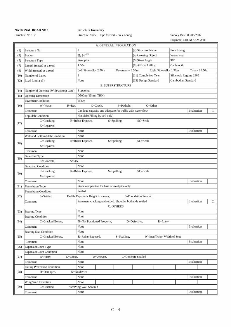
Structure No.: 2
NATIONAL ROAD NO.1
Evaluation
R=Rusty, L=Loose, U=Uneven, C=Concrete Spalled
Evaluation
(25)
(27)
(28)
(29)
None
None
None
None
(18) X=Repaired,
Evaluation
Evaluation
None
None
C=Cracking, R=Rebar Exposed, S=Spalling, SC=Scale
(11) Completion Year
(13) Design Standard
Left Sidewalk= 2.50m Pavement= 6.50m Right Sidewalk= 1.50m Total= 10.50m
Steel pipe
2
Cable optic
Sihanouk Regime 1965
90º
Cambodian Standard
B. SUPERSTRUCTURE
W=Wave, R=Rut, C=Crack, P=Pothole, O=Other(16)
(17) C=Cracking, R=Rebar Exposed, S=Spalling, SC=Scale
X=Repaired
None
Wave
Can load capacity and adequate for traffic with water flow
Not slab (Filling by soil only)
X=Repaired,
None
(19)
C. OTHERS
(20)
(22)
Evaluation
Stone compaction for base of steel pipe only
Settled
S=Settled, E=Pile Exposed - Height in meters, F=Foundation Scoured
None
C=Concrete, S=Steel
None
C=Cracking, R=Rebar Exposed, S=Spalling, SC=Scale
D=Damaged, N=No device
EvaluationNone
C=Cracked, W=Wing Wall Scoured
EvaluationNone
Structure Inventory
None
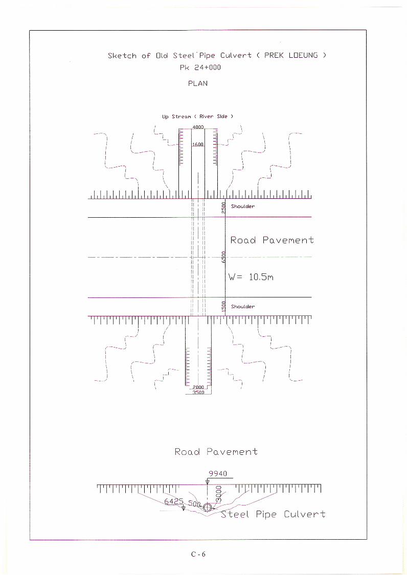
1 opening
D500m (15mm THK)
Structure Name: Pipe Culvert - Prek Loung
A. GENERAL INFORMATION
2 Prek Loung
Survey Date: 03/06/2002
Engineer: CHUM SAM ATH
None
(24)
Pk 24+000 Water way
1.00m
(2) Structure Name
(4) Crossing Object
(6) Skew Angle
(8) Affixed Utility
C - 4

(30) Flood Water Level
(31) Flow Direction
(32) Dimension of River or Channel
(33) River Condition (upstream, downstream)
River Bank Protection Type
River Bank Condition
Comment C
River Bed Protection Type
River Bed Condition
Comment D
Approach condition
Comment
Condition of Approach Slab
Comment
No.
Slope Protection Type
Slope Protection Condition
Comment C
1- This Pipe Culvert for drainage system in the rainning season and protection of emergency flood.2- Position of steel pipe culvert is settled, because according to the appearance which pavement have cracking, base of steel pipe by crushed
stone compaction only and it was scoured. Slope protection both side also scoured. So need to rehabilitation for availability.
H. OVERALL COMMENT
(38)
NATIONAL ROAD NO.1
Structure No.: 2
N=None, R=Riprap (length in meters), G=Gabion, C=Concrete (length in meters)
P=Piled Walls
(37)
D
D=Damaged, S=Scoured, C=Corroded, E=Enchroachment on Stream
G. OVERALL EVLUATION Can serviceability, but need to rehabilitation
(39)
None
C=Fair Condition, A=No Slab, D=Damaged Slab
None Evaluation
F. SLOPE PROTECTION
(40)None
N=None, R=Riprap, G=Gabion, C=Concrete,
P=Piled Walls
D
None Evaluation
None
S= Sinking (height in cm), AS=Scour Behind Abutment (length in meters)
The water can not flow easy and not do direction way to channel Evaluation
E. RIVER BANK AND APPROACH ROAD
None
N=None, R=Riprap (length in meters), G=Gabion,Box C=Concrete (length in meters),
P=Piled Walls
(35)
D and C
D. RIVER CONDITION
1.00 - 1.50m below road level
From River to Lake
Structure Inventory
Structure Name: Pipe Culvert - Prek Loung
Down (WT=3.50m, WB=2.00m, H=2.00m), Up (WT=6.00m, WB=4.00m, H=1.30m)
Downstream: in dry season no water and have some forest
(41) D=Damaged, S=Scoured, C=Corroded, E=Enchroachment on Stream
Damaged by water flow Evaluation
D=Damaged, S=Scoured, C=Corroded, E=Enchroachment on Stream
River bank is the natural soil, so easy to damaged by rain Evaluation
(36)
None
Survey Date: 03/06/2002
Engineer: CHUM SAM ATH
(34)
C - 5

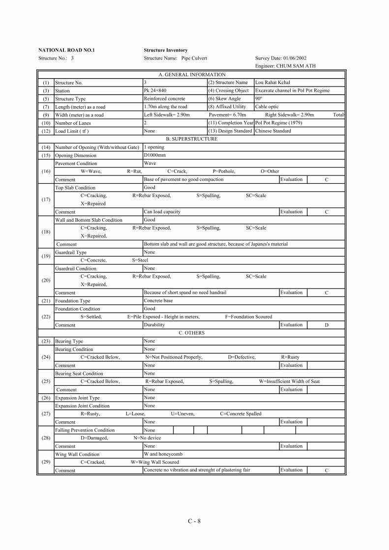
(1) Structure No.(3) Station(5) Structure Type(7) Length (meter) as a road(9) Width (meter) as a road(10) Number of Lanes(12) Load Limit ( tf )
(14) Number of Opening (With/without Gate)(15) Opening Dimension
Pavement Condition
Comment CTop Slab Condition
Comment CWall and Bottom Slab Condition
CommentGuardrail Type
Guardrail Condition
Comment C(21) Foundation Type
Foundation Condition
Comment D
(23) Bearing TypeBearing Condition
CommentBearing Seat Condition
Comment(26) Expansion Joint Type
Expansion Joint Condition
CommentFalling Prevention Condition None
Comment Wing Wall Condition
Comment C
(29)W and honeycomb
C=Cracked, W=Wing Wall ScouredConcrete no vibration and strenght of plastering fair Evaluation
(28) D=Damaged, N=No deviceNone Evaluation
None
(27)None
R=Rusty, L=Loose, U=Uneven, C=Concrete SpalledNone Evaluation
(25)None
C=Cracked Below, R=Rebar Exposed, S=Spalling, W=Insufficient Width of SeatNone Evaluation
C. OTHERSNone
(24)None
C=Cracked Below, N=Not Positioned Properly, D=Defective, R=RustyNone Evaluation
Concrete base
(22)Good
S=Settled, E=Pile Exposed - Height in meters, F=Foundation ScouredDurability Evaluation
(19)None
C=Concrete, S=Steel
(20)
None C=Cracking, R=Rebar Exposed, S=Spalling, SC=Scale X=Repaired,
Because of short spand no need handrail Evaluation
(18)
Good C=Cracking, R=Rebar Exposed, S=Spalling, SC=Scale X=Repaired,
Bottom slab and wall are good structure, because of Japanes's material
(17)
Good C=Cracking, R=Rebar Exposed, S=Spalling, SC=Scale X=Repaired
Can load capacity Evaluation
B. SUPERSTRUCTURE1 openingD1000mm
(16)Wave
W=Wave, R=Rut, C=Crack, P=Pothole, O=OtherBase of pavement no good compaction Evaluation
2 (11) Completion Year Pol Pot Regime (1979)None (13) Design Standard Chinese Standard
1.70m along the road (8) Affixed Utility Cable opticLeft Sidewalk= 2.90m Pavement= 6.70m Right Sidewalk= 2.90m Total=
Pk 24+840 (4) Crossing Object Excavate channel in Pol Pot RegimeReinforced concrete (6) Skew Angle 90º
Engineer: CHUM SAM ATH
A. GENERAL INFORMATION3 (2) Structure Name Lou Rahat Kchal
NATIONAL ROAD NO.1 Structure InventoryStructure No.: 3 Structure Name: Pipe Culvert Survey Date: 01/06/2002
C - 8
(30) Flood Water Level(31) Flow Direction(32) Dimension of River or Channel(33) River Condition (upstream, downstream)
River Bank Protection Type
River Bank Condition
Comment CRiver Bed Protection Type
River Bed Condition
Comment CApproach condition
Comment Condition of Approach Slab
Comment
No.Slope Protection Type
Slope Protection Condition
Comment C
So it is Chinese Standard.3- Top of water level (TWL)
H. OVERALL COMMENT1- For structure need to repair (reconstruction), but the river condition must be new construction both river bank, bed and slope protection.2- Local people said that: this culvert constructed by Chinese Company (Sub-constructor) of government, not Japanese Company.
G. OVERALL EVLUATION Can use for irrigation and traffic, but need to rehabilitation
(41)D
D=Damaged, S=Scoured, C=Corroded, E=Enchroachment on Stream No prevention in rainning season Evaluation
F. SLOPE PROTECTION
(40)None
N=None, R=Riprap, G=Gabion, C=Concrete, P=Piled Walls
(39)
C=Fair Condition, A=No Slab, D=Damaged Slab Evaluation
(38)
S= Sinking (height in cm), AS=Scour Behind Abutment (length in meters) Evaluation
(37)D
D=Damaged, S=Scoured, C=Corroded, E=Enchroachment on Stream In dry season not repair, not prevention Evaluation
(36)None
N=None, R=Riprap (length in meters), G=Gabion, C=Concrete (length in meters) P=Piled Walls
(35)D
D=Damaged, S=Scoured, C=Corroded, E=Enchroachment on Stream In dry season not repair, not prevention Evaluation
(WT=6.00m, WB=4.50m), H=1.50m
In the dry season no water (down/up) but in the rainning season height of level of waterE. RIVER BANK AND APPROACH ROAD
(34)None
N=None, R=Riprap (length in meters), G=Gabion,Box C=Concrete (length in meters), P=Piled Walls
Engineer: CHUM SAM ATH
D. RIVER CONDITIONEvery level TWL=1.50m below road level, but in 1996 TWL=0.20m above road level (Flood emerEAST to WEST (From River to Lake)
NATIONAL ROAD NO.1 Structure InventoryStructure No.: 3 Structure Name: Pipe Culvert Survey Date: 01/06/2002
C - 9


(1) Structure No.(3) Station(5) Structure Type(7) Length (meter) as a road(9) Width (meter) as a road
(10) Number of Lanes(12) Load Limit ( tf )
(14) Number of Opening (With/without Gate)(15) Opening Dimension
Pavement Condition
Comment ATop Slab Condition
Comment AWall and Bottom Slab Condition
Comment AGuardrail Type
Guardrail Condition
Comment A(21) Foundation Type
Foundation Condition
Comment A
(23) Bearing TypeBearing Condition
CommentBearing Seat Condition
Comment(26) Expansion Joint Type
Expansion Joint Condition
CommentFalling Prevention Condition
Comment Wing Wall Condition
Comment
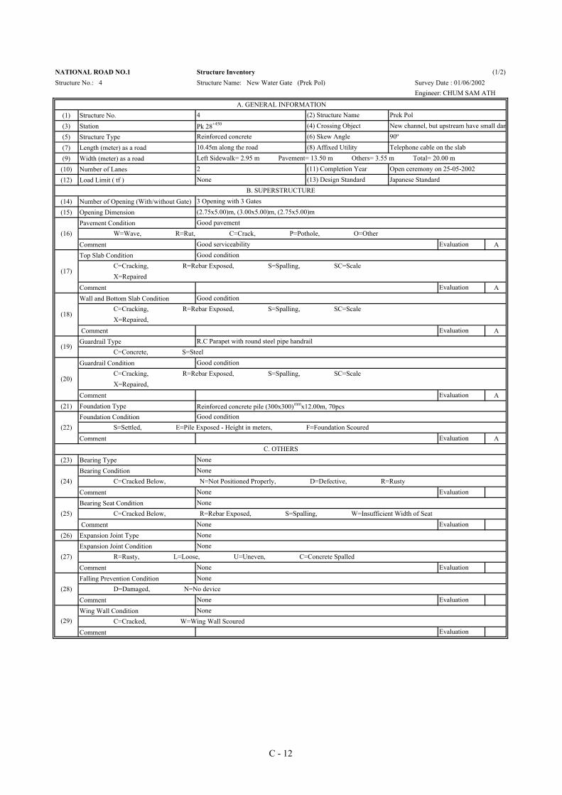
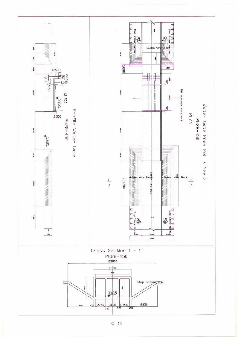
NATIONAL ROAD NO.1 Structure InventoryStructure No.: 4 Structure Name: New Water Gate (Prek Pol) Survey Date : 01/06/2002
Engineer: CHUM SAM ATH
A. GENERAL INFORMATION4 (2) Structure Name Prek Pol
Pk 28+450 (4) Crossing Object New channel, but upstream have small damReinforced concrete (6) Skew Angle 90º10.45m along the road (8) Affixed Utility Telephone cable on the slabLeft Sidewalk= 2.95 m Pavement= 13.50 m Others= 3.55 m Total= 20.00 m2 (11) Completion Year Open ceremony on 25-05-2002None (13) Design Standard Japanese Standard
B. SUPERSTRUCTURE3 Opening with 3 Gates(2.75x5.00)m, (3.00x5.00)m, (2.75x5.00)m
(16)Good pavement
W=Wave, R=Rut, C=Crack, P=Pothole, O=OtherGood serviceability Evaluation
(17)
Good condition C=Cracking, R=Rebar Exposed, S=Spalling, SC=Scale X=Repaired
Evaluation
(18)
Good condition C=Cracking, R=Rebar Exposed, S=Spalling, SC=Scale X=Repaired,
Evaluation
(19)R.C Parapet with round steel pipe handrail
C=Concrete, S=Steel
(20)
Good condition C=Cracking, R=Rebar Exposed, S=Spalling, SC=Scale X=Repaired,
Evaluation
Reinforced concrete pile (300x300)mmx12.00m, 70pcs
(22)Good condition
S=Settled, E=Pile Exposed - Height in meters, F=Foundation ScouredEvaluation
C. OTHERSNone
(24)None
C=Cracked Below, N=Not Positioned Properly, D=Defective, R=RustyNone Evaluation
(25)None
C=Cracked Below, R=Rebar Exposed, S=Spalling, W=Insufficient Width of SeatNone EvaluationNone
(27)None
R=Rusty, L=Loose, U=Uneven, C=Concrete SpalledNone Evaluation
(28)None
D=Damaged, N=No deviceNone Evaluation
(29)None
C=Cracked, W=Wing Wall ScouredEvaluation
(1/2)
C - 12

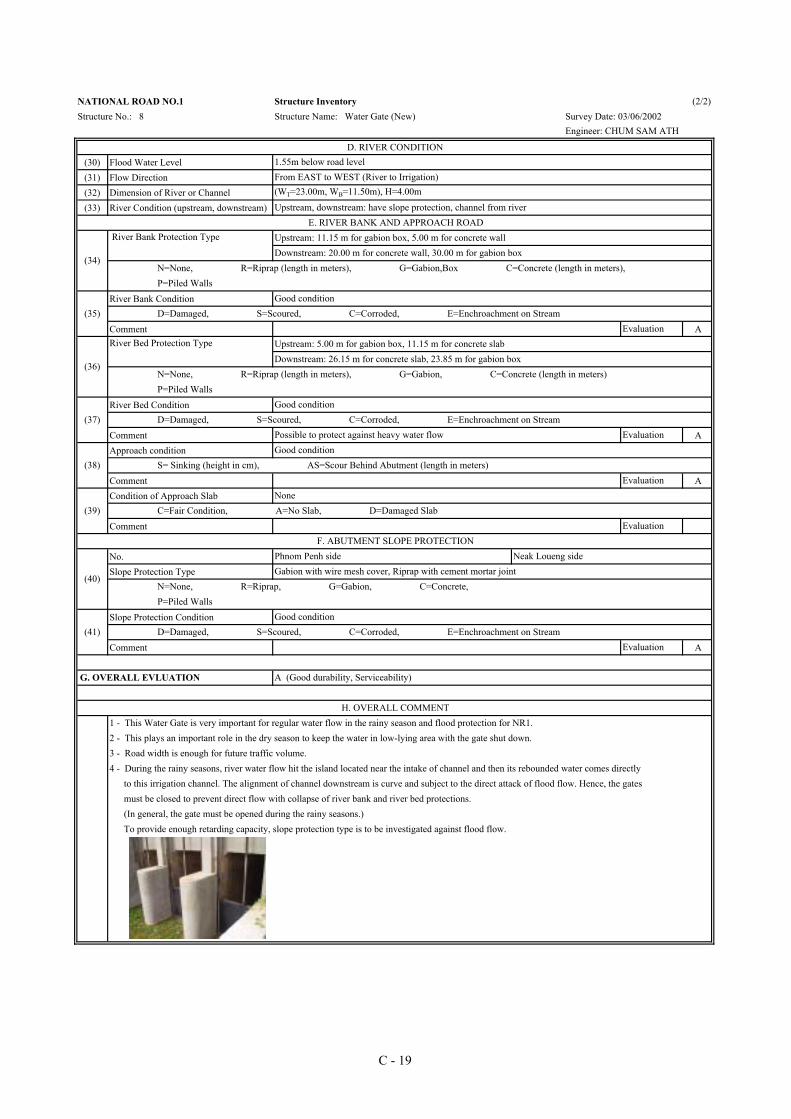
(30) Flood Water Level(31) Flow Direction(32) Dimension of River or Channel(33) River Condition (upstream, downstream)
River Bank Condition
Comment B
River Bed Condition
Comment AApproach condition
Comment ACondition of Approach Slab
Comment
No.Slope Protection Type
Slope Protection Condition
Comment A
NATIONAL ROAD NO.1 Structure InventoryStructure No.: 4 Structure Name: New Water Gate (Prek Pol) Survey Date : 01/06/2002
Engineer: CHUM SAM ATH
D. RIVER CONDITION1.50 m below road levelFrom EAST to WEST (River to Irrigation)(WT=23.80m, WB=10.80m), H=4.20m
Upstream, downstream: have slope protection, channel from riverE. RIVER BANK AND APPROACH ROAD
(34)
Upstream: 11.30 m for gabion box, 5.00 m for concrete wall
N=None, R=Riprap (length in meters), G=Gabion,Box C=Concrete (length in meters), P=Piled Walls
River Bank Protection Type
Downstream: 20.00 m for concrete wall, 30.00 m for gabion box
(35)Good, but some place of G wire mesh have corrotion and cracking in the joint with Riprap
D=Damaged, S=Scoured, C=Corroded, E=Enchroachment on Stream Need some repair Evaluation
(36)
Upstream: 5.00 m for gabion box, 11.30 m for concrete slab
N=None, R=Riprap (length in meters), G=Gabion, C=Concrete (length in meters) P=Piled Walls
River Bed Protection Type
Downstream: 16.30 m for concrete slab, 23.70 m for gabion box
(37)Good
D=Damaged, S=Scoured, C=Corroded, E=Enchroachment on Stream Possible to protect against heavy water flow Evaluation
(38)Good
S= Sinking (height in cm), AS=Scour Behind Abutment (length in meters)Evaluation
(39)None
C=Fair Condition, A=No Slab, D=Damaged SlabEvaluation
F. ABUTMENT SLOPE PROTECTION
(40)
Phnom Penh side Neak Loueng side
N=None, R=Riprap, G=Gabion, C=Concrete, P=Piled Walls
(41)Good condition
D=Damaged, S=Scoured, C=Corroded, E=Enchroachment on Stream Evaluation
2 - This plays an important role in the dry season to keep the water in low-lying area with the gate shut down. 3 - Road width is enough for future traffic volume.
G. OVERALL EVALUATION A (Good durability, Serviceability)
(2/2)
Gabion with wire mesh cover, Riprap with cement mortar joint
4 - As to gabion box for slope protection and river bank protection, wire mesh were corroded. Repair is required.
H. OVERALL COMMENT1 - This Water Gate is very important for regular water flow in the rainy season and flood protection for NR1.
C - 13

(1) Structure No.(3) Station(5) Structure Type(7) Length (meter) as a road(9) Width (meter) as a road(10) Number of Lanes(12) Load Limit ( tf )
(14) Number of Opening (With/without Gate)(15) Opening Dimension
Pavement Condition
Comment ATop Slab Condition
Comment AWall and Bottom Slab Condition
Comment AGuardrail Type
Guardrail Condition
Comment B(21) Foundation Type
Foundation Condition
Comment A
(23) Bearing TypeBearing Condition
CommentBearing Seat Condition
Comment(26) Expansion Joint Type
Expansion Joint Condition
CommentFalling Prevention Condition None
Comment Wing Wall Condition None
Comment A
NATIONAL ROAD NO.1 Structure InventoryStructure No.: 5 Structure Name: Water Gate (New) Survey Date : 02/06/2002
Engineer : CHUM SAM ATH
A. GENERAL INFORMATION5 (2) Structure Name Prek Takao
Pk 31+120 (4) Crossing Object Both side stream are channelReinforced concrete (6) Skew Angle 70º 10.55m (8) Affixed Utility Telephone cableLeft Sidewalk= 10.00 m Pavement= 13.50 m Right Sidewalk=0.00 m Total= 23.50 m2 (11) Completion Year 2002None (13) Design Standard Japanese Standard
B. SUPERSTRUCTURE3 Openings with 3 Gates(2.75x5.10)m, (3.00x5.10)m, (2.75x5.10)m
(16)Good condition
W=Wave, R=Rut, C=Crack, P=Pothole, O=OtherGood serviceability Evaluation
(17)
Good condition C=Cracking, R=Rebar Exposed, S=Spalling, SC=Scale X=Repaired
Evaluation
(18)
Cracking (Filled with cement mortar in P-con form work) C=Cracking, R=Rebar Exposed, S=Spalling, SC=Scale X=Repaired,
Already repaired and in good condition Evaluation
(19)R.C Parapet with round steel pipe handrail
C=Concrete, S=Steel
(20)
Vertical crack, P-con not to be filled with mortar after removal of separaters C=Cracking, R=Rebar Exposed, S=Spalling, SC=Scale X=Repaired,
Need repair works Evaluation
R.C pile (300x300)mmx12.00m, 84pcs
(22)Good condition
S=Settled, E=Pile Exposed - Height in meters, F=Foundation ScouredEvaluation
C. OTHERSNone
(24)None
C=Cracked Below, N=Not Positioned Properly, D=Defective, R=RustyNone Evaluation
(25)None
C=Cracked Below, R=Rebar Exposed, S=Spalling, W=Insufficient Width of SeatNone EvaluationNone
(27)None
R=Rusty, L=Loose, U=Uneven, C=Concrete SpalledNone Evaluation
(28) D=Damaged, N=No deviceNone Evaluation
(29) C=Cracked, W=Wing Wall ScouredEvaluation
(1/2)
C - 15

(30) Flood Water Level(31) Flow Direction(32) Dimension of River or Channel(33) River Condition (upstream, downstream)
River Bank Condition
Comment A
River Bed Condition
Comment AApproach condition
Comment ACondition of Approach Slab
Comment
No.Slope Protection Type
Slope Protection Condition
Comment B
NATIONAL ROAD NO.1 Structure InventoryStructure No.: 5 Structure Name: Water Gate (New) Survey Date : 02/06/2002
Engineer : CHUM SAM ATH
D. RIVER CONDITION2.70m below road levelFrom EAST to WEST (River to Irrigation)(WT=23.50m, WB=14.30m), H=4.30m
Upstream, downstream: have slope protection, channel from riverE. RIVER BANK AND APPROACH ROAD
(34)
Upstream: 11.45 m for gabion box, 5.00 m for concrete wall
N=None, R=Riprap (length in meters), G=Gabion,Box C=Concrete (length in meters), P=Piled Walls
River Bank Protection Type
Downstream: 20.00 m for concrete wall, 30.00 m for gabion box
(35)Good condition
D=Damaged, S=Scoured, C=Corroded, E=Enchroachment on Stream Evaluation
(36)
Upstream: 5.00 m for gabion box, 11.45 m for concrete slab
N=None, R=Riprap (length in meters), G=Gabion, C=Concrete (length in meters) P=Piled Walls
River Bed Protection Type
Downstream: 26.45 m for concrete slab, 23.55 m for gabion box
(37)Good condition
D=Damaged, S=Scoured, C=Corroded, E=Enchroachment on Stream Possible to protect against heavy water flow Evaluation
(38)Good condition
S= Sinking (height in cm), AS=Scour Behind Abutment (length in meters)Evaluation
(39)None
C=Fair Condition, A=No Slab, D=Damaged SlabEvaluation
F. ABUTMENT SLOPE PROTECTION
(40)
Phnom Penh side Neak Loueng side
N=None, R=Riprap, G=Gabion, C=Concrete, P=Piled Walls
Gabion with wire mesh cover, Riprap with cement mortar joint
(41)Some cracks occur at the joint with Riprap.
D=Damaged, S=Scoured, C=Corroded, E=Enchroachment on Stream Need following inspection Evaluation
2 - This plays an important role in the dry season to keep the water in low-lying area with the gate shut down. 3 - Road width is enough for future traffic volume.
G. OVERALL EVLUATION A (Good durability, Serviceability)
4 - As to gabion box for slope protection and river bank protection, wire mesh were corroded. Repair is required.
H. OVERALL COMMENT1 - This Water Gate is very important for regular water flow in the rainy season and flood protection for NR1.
C - 16


(1) Structure No.(3) Station(5) Structure Type(7) Length (meter) as a road(9) Width (meter) as a road(10) Number of Lanes(12) Load Limit ( tf )
(14) Number of Opening (With/without Gate)(15) Opening Dimension
Pavement Condition
Comment ATop Slab Condition
Comment AWall and Bottom Slab Condition
Comment AGuardrail Type
Guardrail Condition
Comment A(21) Foundation Type
Foundation Condition
Comment A
(23) Bearing TypeBearing Condition
CommentBearing Seat Condition
Comment(26) Expansion Joint Type
Expansion Joint Condition
CommentFalling Prevention Condition None
Comment Wing Wall Condition None
Comment A
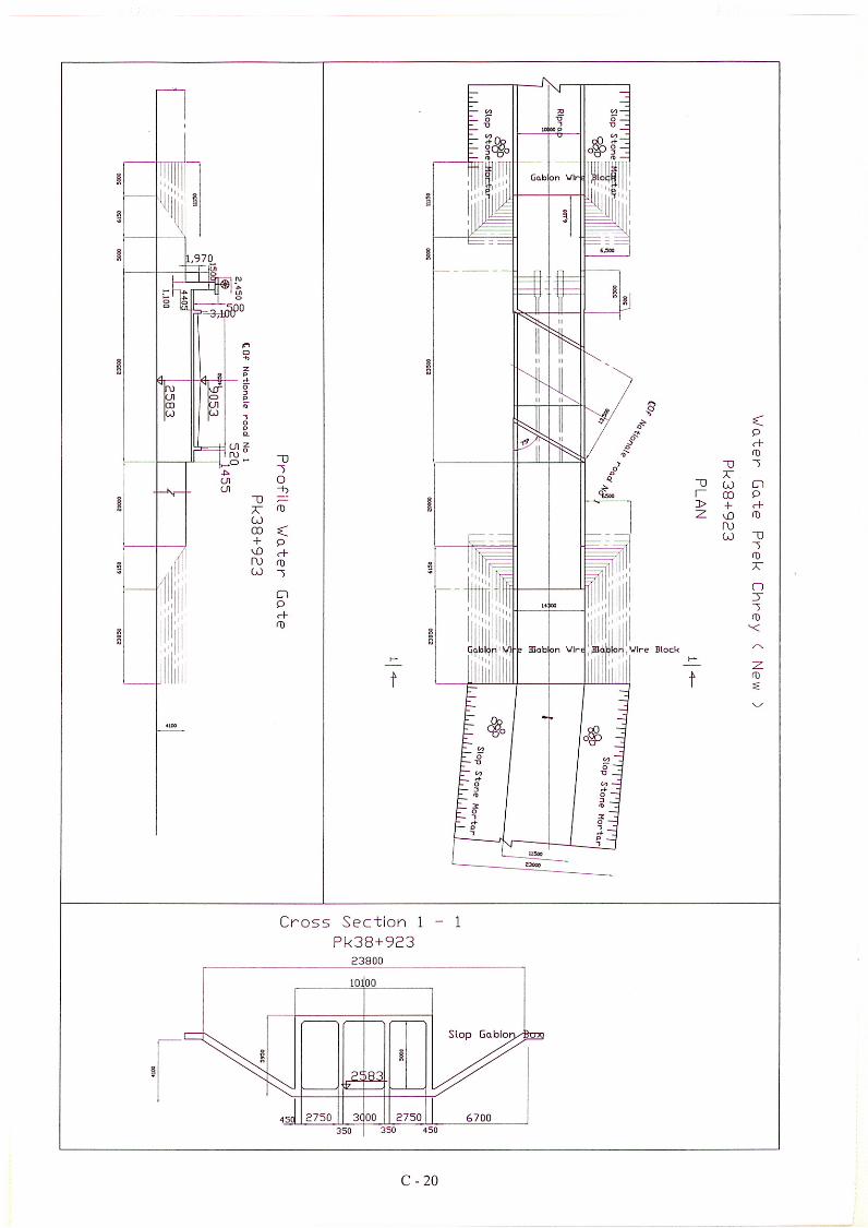
NATIONAL ROAD NO.1 Structure Inventory (1/2)Structure No.: 8 Structure Name: Water Gate (New) Survey Date: 03/06/2002
Engineer: CHUM SAM ATH
A. GENERAL INFORMATION8 (2) Structure Name Prek ChreyPk 38+923 (4) Crossing Object Both side stream are channelReinforced concrete (6) Skew Angle 75º10.40m (8) Affixed Utility Telephone cableLeft Sidewalk= 10.00 m Pavement= 13.50 m Right Sidewalk=0.00 m Total= 23.50 m2 (11) Completion Year 2002None (13) Design Standard Japanese standard
B. SUPERSTRUCTURE3 Openings with 3 Gates(2.75x5.00)m, (3.00x5.00)m, (2.75x5.00)m
(16)Good condition
W=Wave, R=Rut, C=Crack, P=Pothole, O=OtherGood serviceability Evaluation
(17)
Good condition C=Cracking, R=Rebar Exposed, S=Spalling, SC=Scale X=Repaired
Evaluation
(18)
Cracking (Filled with cement mortar in P-con form work) C=Cracking, R=Rebar Exposed, S=Spalling, SC=Scale X=Repaired,
EvaluationAlready repaired and in good condition
(19)R.C Parapet with round steel pipe handrail
C=Concrete, S=Steel
(20)
Good condition C=Cracking, R=Rebar Exposed, S=Spalling, SC=Scale X=Repaired,
Evaluation
Reinforced concrete pile (300x300)mmx12.00m, 84pcs
(22)Good condition
S=Settled, E=Pile Exposed - Height in meters, F=Foundation ScouredEvaluation
C. OTHERSNone
(24)None
C=Cracked Below, N=Not Positioned Properly, D=Defective, R=RustyNone Evaluation
(25)None
C=Cracked Below, R=Rebar Exposed, S=Spalling, W=Insufficient Width of SeatNone EvaluationNone
(27)None
R=Rusty, L=Loose, U=Uneven, C=Concrete SpalledNone Evaluation
(28) D=Damaged, N=No deviceNone Evaluation
(29) C=Cracked, W=Wing Wall ScouredEvaluation
C - 18
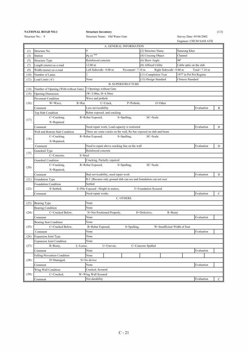
(30) Flood Water Level(31) Flow Direction(32) Dimension of River or Channel(33) River Condition (upstream, downstream)
River Bank Condition
Comment A
River Bed Condition
Comment AApproach condition
Comment ACondition of Approach Slab
Comment
No.Slope Protection Type
Slope Protection Condition
Comment A
NATIONAL ROAD NO.1 Structure Inventory (2/2)Structure No.: 8 Structure Name: Water Gate (New) Survey Date: 03/06/2002
Engineer: CHUM SAM ATH
D. RIVER CONDITION1.55m below road levelFrom EAST to WEST (River to Irrigation)(WT=23.00m, WB=11.50m), H=4.00m
Upstream, downstream: have slope protection, channel from river
River Bed Protection Type
Downstream: 26.15 m for concrete slab, 23.85 m for gabion box
River Bank Protection Type
Downstream: 20.00 m for concrete wall, 30.00 m for gabion box
E. RIVER BANK AND APPROACH ROAD
(34)
Upstream: 11.15 m for gabion box, 5.00 m for concrete wall
N=None, R=Riprap (length in meters), G=Gabion,Box C=Concrete (length in meters), P=Piled Walls
(35)Good condition
D=Damaged, S=Scoured, C=Corroded, E=Enchroachment on Stream Evaluation
(36)
Upstream: 5.00 m for gabion box, 11.15 m for concrete slab
N=None, R=Riprap (length in meters), G=Gabion, C=Concrete (length in meters) P=Piled Walls
(37)Good condition
D=Damaged, S=Scoured, C=Corroded, E=Enchroachment on Stream Possible to protect against heavy water flow Evaluation
(38)Good condition
S= Sinking (height in cm), AS=Scour Behind Abutment (length in meters)Evaluation
(39)None
C=Fair Condition, A=No Slab, D=Damaged SlabEvaluation
F. ABUTMENT SLOPE PROTECTION
(40)
Phnom Penh side Neak Loueng side
N=None, R=Riprap, G=Gabion, C=Concrete, P=Piled Walls
Gabion with wire mesh cover, Riprap with cement mortar joint
(41)Good condition
D=Damaged, S=Scoured, C=Corroded, E=Enchroachment on Stream Evaluation
G. OVERALL EVLUATION A (Good durability, Serviceability)
H. OVERALL COMMENT1 - This Water Gate is very important for regular water flow in the rainy season and flood protection for NR1.2 - This plays an important role in the dry season to keep the water in low-lying area with the gate shut down. 3 - Road width is enough for future traffic volume.4 - During the rainy seasons, river water flow hit the island located near the intake of channel and then its rebounded water comes directly to this irrigation channel. The alignment of channel downstream is curve and subject to the direct attack of flood flow. Hence, the gates must be closed to prevent direct flow with collapse of river bank and river bed protections.
To provide enough retarding capacity, slope protection type is to be investigated against flood flow. (In general, the gate must be opened during the rainy seasons.)
C - 19
(1) Structure No.(3) Station(5) Structure Type(7) Length (meter) as a road(9) Width (meter) as a road(10) Number of Lanes(12) Load Limit ( tf )
(14) Number of Opening (With/without Gate)(15) Opening Dimension
Pavement Condition
Comment BTop Slab Condition
Comment DWall and Bottom Slab Condition
Comment DGuardrail Type
Guardrail Condition
Comment D(21) Foundation Type
Foundation Condition
Comment C
(23) Bearing TypeBearing Condition
CommentBearing Seat Condition
Comment(26) Expansion Joint Type
Expansion Joint Condition
CommentFalling Prevention Condition None
Comment Wing Wall Condition
Comment C
NATIONAL ROAD NO.1 Structure Inventory (1/2)Structure No.: 9 Structure Name: Old Water Gate Survey Date: 05/06/2002
Engineer: CHUM SAM ATH
A. GENERAL INFORMATION9 (2) Structure Name Samrong Kher
Pk 41+040 (4) Crossing Object Channel Reinforced concrete (6) Skew Angle 90º12.00 m (8) Affixed Utility Cable optic on the slabLeft Sidewalk= 0.00 m Pavement= 7.10 m Right Sidewalk= 0.00 m Total= 7.10 m2 (11) Completion Year 1977 in Pol Pot RegimeNone (13) Design Standard Chinese Standard
B. SUPERSTRUCTURE3 Openings without Gate(W=2.00m, H=4.50m)
(16)Wave and pothole
W=Wave, R=Rut, C=Crack, P=Pothole, O=OtherLess serviceability Evaluation
(17)
Rebar exposed, and cracking C=Cracking, R=Rebar Exposed, S=Spalling, SC=Scale X=Repaired
Need repair work, Load capacity is restricted Evaluation
(18)
There are some cracks on the wall, Re-bar exposed on slab and beam C=Cracking, R=Rebar Exposed, S=Spalling, SC=Scale X=Repaired,
EvaluationNeed to repair above cracking line on the wall
(19)Reinforced concrete
C=Concrete, S=Steel
(20)
Cracking, Partially repaired C=Cracking, R=Rebar Exposed, S=Spalling, SC=Scale X=Repaired,
Bad serviceability, need repair work EvaluationR.C (Because only ground slab can see and foundation can not see)
(22)Settled
S=Settled, E=Pile Exposed - Height in meters, F=Foundation ScouredNeed repair works Evaluation
C. OTHERSNone
(24)None
C=Cracked Below, N=Not Positioned Properly, D=Defective, R=RustyNone Evaluation
(25)None
C=Cracked Below, R=Rebar Exposed, S=Spalling, W=Insufficient Width of SeatNone EvaluationNone
(27)None
R=Rusty, L=Loose, U=Uneven, C=Concrete SpalledNone Evaluation
(28) D=Damaged, N=No deviceNone Evaluation
(29) C=Cracked, W=Wing Wall ScouredNot durability Evaluation
Cracked, Scoured
C - 21
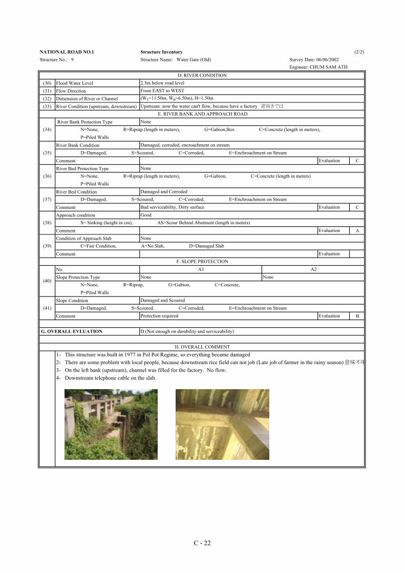
(30) Flood Water Level(31) Flow Direction(32) Dimension of River or Channel(33) River Condition (upstream, downstream)
River Bank Protection Type
River Bank Condition
Comment CRiver Bed Protection Type
River Bed Condition
Comment CApproach condition
Comment ACondition of Approach Slab
Comment
No.Slope Protection Type
Slope Condition
Comment B
NATIONAL ROAD NO.1 Structure Inventory (2/2)Structure No.: 9 Structure Name: Water Gate (Old) Survey Date: 06/06/2002
Engineer: CHUM SAM ATH
D. RIVER CONDITION2.5m below road levelFrom EAST to WEST(WT=11.50m, WB=6.50m), H=1.50m
Upstream: now the water can't flow, because have a factory 逆向きでは
E. RIVER BANK AND APPROACH ROAD
(34)None
N=None, R=Riprap (length in meters), G=Gabion,Box C=Concrete (length in meters), P=Piled Walls
(35)Damaged, corroded, encroachment on stream
D=Damaged, S=Scoured, C=Corroded, E=Enchroachment on Stream Evaluation
(36)None
N=None, R=Riprap (length in meters), G=Gabion, C=Concrete (length in meters) P=Piled Walls
(37)Damaged and Corroded
D=Damaged, S=Scoured, C=Corroded, E=Enchroachment on Stream Bad serviceability, Dirty surface Evaluation
(38)Good
S= Sinking (height in cm), AS=Scour Behind Abutment (length in meters)Evaluation
(39)None
C=Fair Condition, A=No Slab, D=Damaged SlabEvaluation
F. SLOPE PROTECTION
(40)
A1 A2None None
N=None, R=Riprap, G=Gabion, C=Concrete, P=Piled Walls
(41)Damaged and Scoured
D=Damaged, S=Scoured, C=Corroded, E=Enchroachment on Stream Protection required Evaluation
G. OVERALL EVLUATION D (Not enough on durability and serviceability)
H. OVERALL COMMENT1- This structure was built in 1977 in Pol Pot Regime, so everything became damaged2- There are some problem with local people, because downstream rice field can not job (Late job of farmer in the rainy season)意味不明
3- On the left bank (upstream), channel was filled for the factory. No flow.4- Downstream telephone cable on the slab.
C - 22


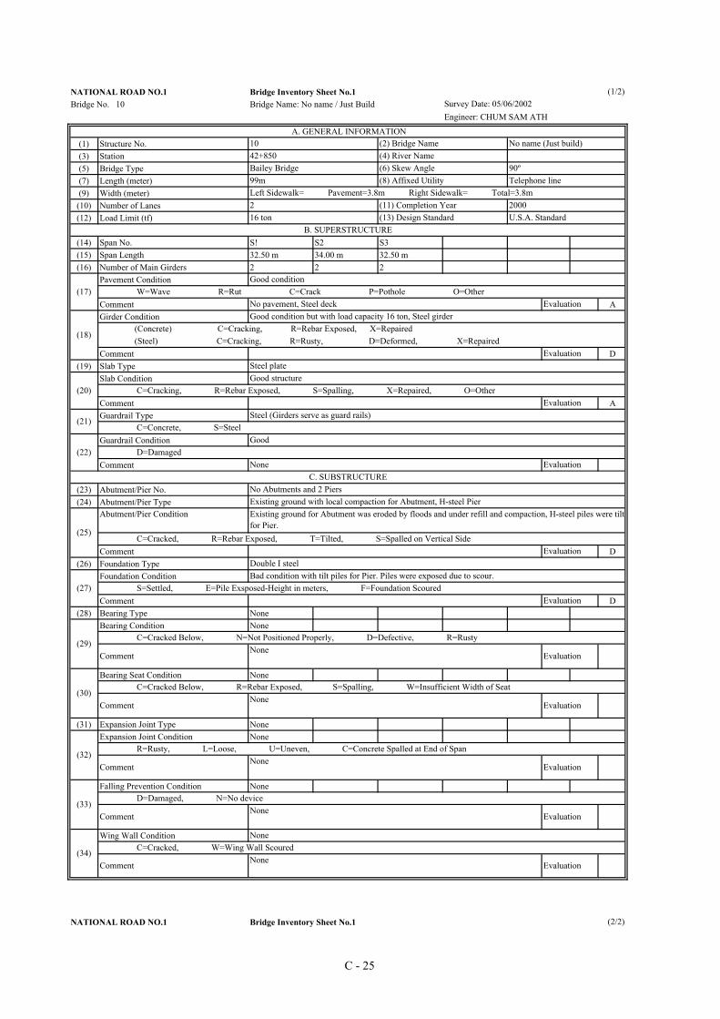
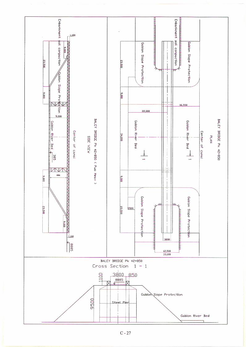
NATIONAL ROAD NO.1 Bridge Inventory Sheet No.1Bridge No. 10 Bridge Name: No name / Just Build
(1) Structure No.(3) Station(5) Bridge Type(7) Length (meter)(9) Width (meter)(10) Number of Lanes(12) Load Limit (tf)
(14) Span No. S! S2 S3(15) Span Length 32.50 m 34.00 m 32.50 m(16) Number of Main Girders 2 2 2
Pavement Condition
Comment AGirder Condition
Comment D(19) Slab Type
Slab Condition
Comment AGuardrail Type
Guardrail Condition
Comment
(23) Abutment/Pier No.(24) Abutment/Pier Type
Abutment/Pier Condition
Comment D(26) Foundation Type
Foundation Condition
Comment D(28) Bearing Type None
Bearing Condition None
Bearing Seat Condition None
(31) Expansion Joint Type NoneExpansion Joint Condition None
Falling Prevention Condition None
Wing Wall Condition
NATIONAL ROAD NO.1 Bridge Inventory Sheet No.1
Survey Date: 05/06/2002Engineer: CHUM SAM ATH
A. GENERAL INFORMATION10 (2) Bridge Name No name (Just build)42+850 (4) River NameBailey Bridge (6) Skew Angle 90º99m (8) Affixed Utility Telephone lineLeft Sidewalk= Pavement=3.8m Right Sidewalk= Total=3.8m2 (11) Completion Year 200016 ton (13) Design Standard U.S.A. Standard
B. SUPERSTRUCTURE
(17)Good condition
W=Wave R=Rut C=Crack P=Pothole O=OtherNo pavement, Steel deck Evaluation
(18) (Concrete) C=Cracking, R=Rebar Exposed, X=Repaired (Steel) C=Cracking, R=Rusty, D=Deformed, X=Repaired
Evaluation
Evaluation
(21) C=Concrete, S=Steel
Bad condition with tilt piles for Pier. Piles were exposed due to scour.
(20) C=Cracking, R=Rebar Exposed, S=Spalling, X=Repaired, O=Other
(22) D=Damaged None Evaluation
Good
C. SUBSTRUCTURENo Abutments and 2 PiersExisting ground with local compaction for Abutment, H-steel Pier
(25)
Existing ground for Abutment was eroded by floods and under refill and compaction, H-steel piles were tiltfor Pier.
C=Cracked, R=Rebar Exposed, T=Tilted, S=Spalled on Vertical SideEvaluation
(27) S=Settled, E=Pile Exsposed-Height in meters, F=Foundation Scoured
Double I steel
Evaluation
(34)
None C=Cracked, W=Wing Wall Scoured
Comment None Evaluation
(29)
C=Cracked Below, N=Not Positioned Properly, D=Defective, R=Rusty
CommentNone
Evaluation
(30) C=Cracked Below, R=Rebar Exposed, S=Spalling, W=Insufficient Width of Seat
CommentNone
Evaluation
(32) R=Rusty, L=Loose, U=Uneven, C=Concrete Spalled at End of Span
CommentNone
Evaluation
(33) D=Damaged, N=No device
CommentNone
Evaluation
(2/2)
(1/2)
Good condition but with load capacity 16 ton, Steel girder
Steel plateGood structure
Steel (Girders serve as guard rails)
C - 25

Bridge No. 10 Bridge Name: No name / Just Build
(35) Flood Water Level(36) Flow Direction(37) Dimension of River or Channel(38) River Condition (upstream, downstream)
River Bank Protection Type
River Bank Condition
CommentRiver Bed Protection Type
River Bed Condition
Comment DApproach Condition
Comment DCondition of Approach Slab
Comment
Abutment No.Slope Protection Type
Slope Protection Condition
Comment D
Survey Date: 05/06/2002Engineer: CHUM SAM ATH
D. RIVER CONDITION1.00m below road levelFrom EAST to WEST (From River to Fields)No dimension, because there is no canalNo channel, Field both upstream and downstream
E. RIVER BANK AND APPROACH ROAD
(39)None
N=None, G=Gabion, P=Piled Walls C=Concrete (Length in meters), O=Other (Length in meters)
(40)None (River doesn't exist.)
D=Damaged, S=Scoured, C=Corroded, E=Encroachment on StreamEvaluation
(41)None (River doesn't exist.)
N=None, R=Riprap (Length in meters), G=Gabion, P=Piled Walls C=Concrete (Length in meters)
(42)Seriosly scoured
D=Damaged, S=Scoured, C=Corroded, E=Encroachment on StreamRiver bed protection is required. Evaluation
(43)Scoured
S=Sinking (height in cm), AS=Scour Behind Abutment (length in meters)Evaluation
(44)None
C=Fair Condition, A=No Slab, D=Damaged SlabEvaluation
F. ABUTMENT SLOPE PROTECTION
(45)
A1 A2None (Gabion box is under construction for slopeprotection)
None (Gabion box is under construction for slopeprotection)
N=None, R=Riprap, G=Gabion, C=Concrete, P=Piled Walls, O=Other
(46)Eroded, Scoured
D=Damaged, S=Scoured, C=Corroded, E=Encroachment on StreamEvaluation
G. OVERALL EVALUATION D (This bridge is subject to load limit. Road width is not enough for future traffic. This structure type isnot appropriate against flood effect.)
3 - Serious flood damages around this bridge every year.4 - This bridge is reconstructed by Ministry of Public Work and Transport (MPWT)
H. OVERALL COMMENT1 - There was a box culvert before. However, due to serious flood damage, the Government cut the embankment here and constructe a BaileyBridge.2 - Load capacity 16 ton and speed limit of 5km/h
C - 26
(1) Structure No.(3) Station(5) Structure Type(7) Length (meter) as a road(9) Width (meter) as a road(10) Number of Lanes(12) Load Limit ( tf )
(14) Number of Opening (With/without Gate)(15) Opening Dimension
Pavement Condition
Comment ATop Slab Condition
Comment AWall and Bottom Slab Condition
Comment AGuardrail Type
Guardrail Condition
Comment A(21) Foundation Type
Foundation Condition
Comment A
(23) Bearing TypeBearing Condition
CommentBearing Seat Condition
Comment(26) Expansion Joint Type
Expansion Joint Condition
CommentFalling Prevention Condition None
Comment Wing Wall Condition
Comment
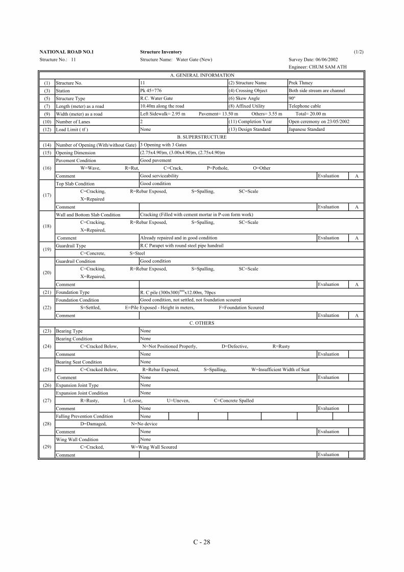
NATIONAL ROAD NO.1 Structure Inventory (1/2)Structure No.: 11 Structure Name: Water Gate (New) Survey Date: 06/06/2002
Engineer: CHUM SAM ATH
A. GENERAL INFORMATION11 (2) Structure Name Prek ThmeyPk 45+776 (4) Crossing Object Both side stream are channelR.C. Water Gate (6) Skew Angle 90º10.40m along the road (8) Affixed Utility Telephone cableLeft Sidewalk= 2.95 m Pavement= 13.50 m Others= 3.55 m Total= 20.00 m2 (11) Completion Year Open ceremony on 23/05/2002None (13) Design Standard Japanese Standard
B. SUPERSTRUCTURE3 Opening with 3 Gates(2.75x4.90)m, (3.00x4.90)m, (2.75x4.90)m
(16)Good pavement
W=Wave, R=Rut, C=Crack, P=Pothole, O=OtherGood serviceability Evaluation
(17)
Good condition C=Cracking, R=Rebar Exposed, S=Spalling, SC=Scale X=Repaired
Evaluation
(18)
Cracking (Filled with cement mortar in P-con form work) C=Cracking, R=Rebar Exposed, S=Spalling, SC=Scale X=Repaired,
EvaluationAlready repaired and in good condition
(19)R.C Parapet with round steel pipe handrail
C=Concrete, S=Steel
(20)
Good condition C=Cracking, R=Rebar Exposed, S=Spalling, SC=Scale X=Repaired,
Evaluation
R. C pile (300x300)mmx12.00m, 70pcs
(22)Good condition, not settled, not foundation scoured
S=Settled, E=Pile Exposed - Height in meters, F=Foundation ScouredEvaluation
C. OTHERSNone
(24)None
C=Cracked Below, N=Not Positioned Properly, D=Defective, R=RustyNone Evaluation
(25)None
C=Cracked Below, R=Rebar Exposed, S=Spalling, W=Insufficient Width of SeatNone EvaluationNone
(27)None
R=Rusty, L=Loose, U=Uneven, C=Concrete SpalledNone Evaluation
(28) D=Damaged, N=No deviceNone Evaluation
(29)None
C=Cracked, W=Wing Wall ScouredEvaluation
C - 28

(30) Flood Water Level(31) Flow Direction(32) Dimension of River or Channel(33) River Condition (upstream, downstream)
River Bank Condition
Comment B
River Bed Condition
Comment AApproach condition
Comment ACondition of Approach Slab
Comment
No.Slope Protection Type
Slope Protection Condition
Comment A
NATIONAL ROAD NO.1 Structure Inventory (2/2)Structure No.: 11 Structure Name: Water Gate (New) Survey Date: 06/06/2002
Engineer: CHUM SAM ATH
D. RIVER CONDITION3.2m below road levelFrom EAST to WEST (River to Irrigation)(WT=20.20m, WB=8.80m), H=4.00m
Upstream, downstream: have slope protection, channel from riverE. RIVER BANK AND APPROACH ROAD
(34)
Upstream: 11.15 m for gabion box, 5.00 m for concrete wall
N=None, R=Riprap (length in meters), G=Gabion,Box C=Concrete (length in meters), P=Piled Walls
River Bank Protection Type
Downstream: 20.00 m for concrete wall, 30.00 m for gabion box
(35)Good, but some place of G wire mesh have corrotion and cracking in the joint with Riprap
D=Damaged, S=Scoured, C=Corroded, E=Enchroachment on Stream Need some repair Evaluation
(36)
Upstream: 5.00 m for gabion box, 11.15 m for concrete slab
N=None, R=Riprap (length in meters), G=Gabion, C=Concrete (length in meters) P=Piled Walls
River Bed Protection Type
Downstream: 26.15 m for concrete slab, 23.85 m for gabion box
(37)Good condition
D=Damaged, S=Scoured, C=Corroded, E=Enchroachment on Stream Good serviceability for water flow Evaluation
(38)Good
S= Sinking (height in cm), AS=Scour Behind Abutment (length in meters) Evaluation
(39)None
C=Fair Condition, A=No Slab, D=Damaged Slab Evaluation
F. ABUTMENT SLOPE PROTECTION
(40)
Phnom Penh side Neak Loueng sideGabion with wire mesh cover, Riprap with cement mortar joint
N=None, R=Riprap, G=Gabion, C=Concrete, P=Piled Walls
(41)Good condition (some G mesh wire corroded)
D=Damaged, S=Scoured, C=Corroded, E=Enchroachment on Stream Evaluation
G. OVERALL EVLUATION A (Good durability, Serviceability)
H. OVERALL COMMENT1 - This Water Gate is very important for regular water flow in the rainy season and flood protection for NR1.2 - This plays an important role in the dry season to keep the water in low-lying area with the gate shut down.
4 - As to gabion box for slope protection and river bank protection, wire mesh were corroded. Repair is required. 3 - Road width is enough for future traffic volume.
C - 29


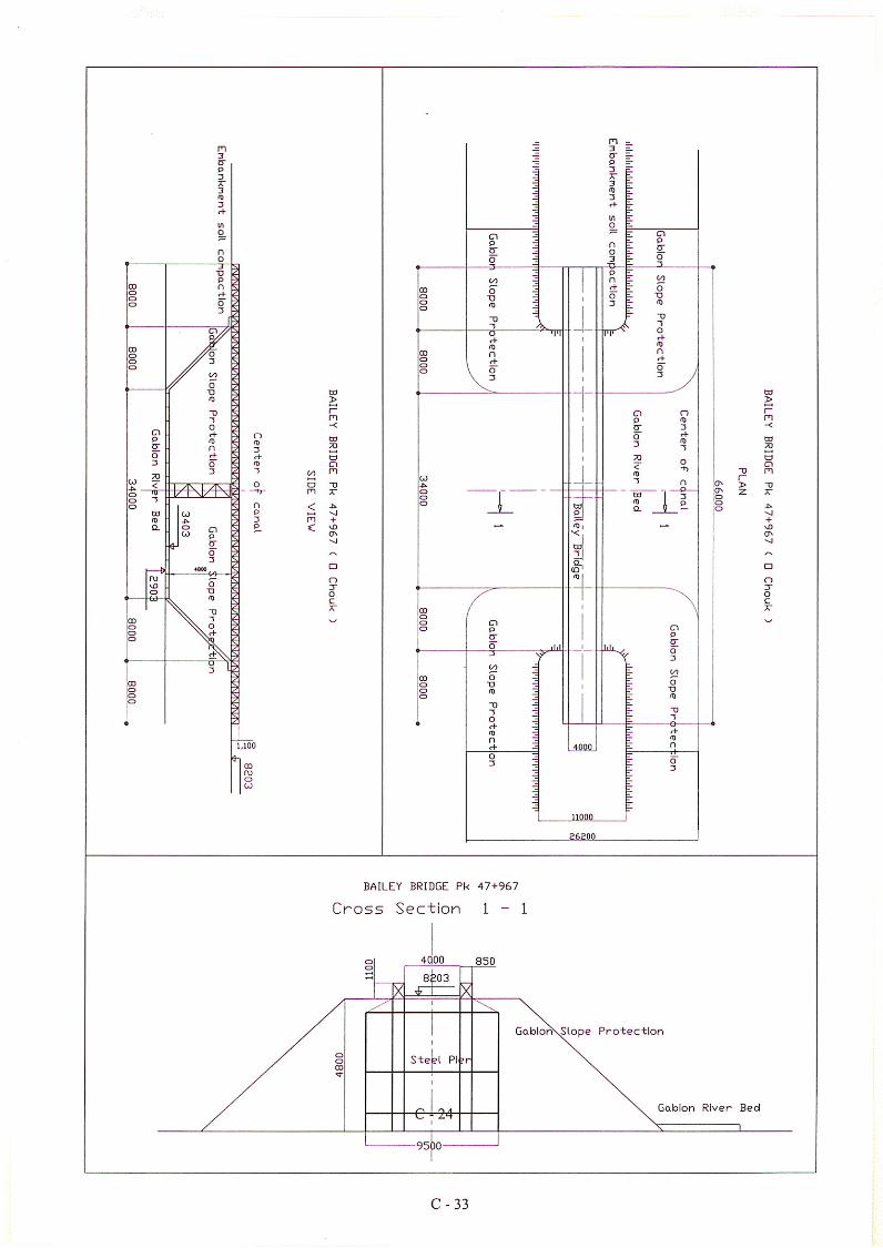
NATIONAL ROAD NO.1 Bridge InventoryBridge No. 12 Bridge Name: O. CHHOUK
(1) Structure No.(3) Station(5) Bridge Type(7) Length (meter)(9) Width (meter)
(10) Number of Lanes(12) Load Limit (tf)
(14) Span No. S1 S2(15) Span Length 33.0 m 33.0 m(16) Number of Main Girders 2 2
Pavement Condition
Comment AGirder Condition
Comment D(19) Slab Type
Slab Condition
Comment AGuardraill Type
Guardrail Condition
Comment
(23) Abutment/Pier No.(24) Abutment/Pier Type
Abutment/Pier Condition
Comment D(26) Foundation Type
Foundation Condition
Comment D(28) Bearing Type None
Bearing Condition None
CommentBearing Seat Condition None
Comment(31) Expansion Joint Type None
Expansion Joint Condition None
CommentFalling Prevention Condition None
CommentWing Wall Condition
Comment
Survey Date: 06/06/2002Engineer: CHUM SAM ATH
A. GENERAL INFORMATION12 (2) Bridge Name O. CHHOUKPk 47+967 (4) River Name O. CHHOUKBailey bridge (6) Skew Angle 90º66m (8) Affixed Utility Both side are agricultural fieldLeft Sidewalk= 0.00m Pavement= 4m Right Sidewalk= 0.00m Total= 4m2 (11) Completion Year 200016 ton (13) Design Standard U.S.A. Standard
B. SUPERSTRUCTURE
(17)Good condition
W=Wave R=Rut C=Crack P=Pothole O=OtherNo pavement, Steel deck Evaluation
(18) (Concrete) C=Cracking, R=Rebar Exposed, S=Spalling, X=Repaired (Steel) C=Cracking, R=Rusty, D=Deformed, X=Repaired
Evaluation
(20)Good structure
C=Cracking, R=Rebar Exposed, S=Spalling, X=Repaired, O=OtherEvaluation
(21) C=Concrete, S=Steel
None Evaluation
(22) D=Damaged None Evaluation
C. SUBSTRUCTURENo Abutment and 1 PierExisting ground with local compaction for Abutment, H-steel Pier
(25)
Existing ground for Abutment was eroded by floods and under refill and compaction, H-steel piles were tilt forPier.
C=Cracked, R=Rebar Exposed, T=Tilted, S=Spalled on Vertical SideEvaluation
(27)Bad condition with tilt piles for Pier. Piles were exposed due to scour.
S=Settled, E=Pile Exsposed-Height in meters, F=Foundation ScouredEvaluation
(29)
C=Cracked Below, N=Not Positioned Properly, D=Defective, R=RustyNone Evaluation
(30) C=Cracked Below, R=Rebar Exposed, S=Spalling, W=Insufficient Width of SeatNone Evaluation
(32) R=Rusty, L=Loose, U=Uneven, C=Concrete Spalled at End of SpanNone Evaluation
(34)
(33) D=Damaged, N=No deviceNone EvaluationNone
(1/2)
Good condition but with load capacity 16 ton, Steel girder
Steel plate
Steel (Girders serve as guard rails)
Good
Double I steel
C=Cracked, W=Wing Wall Scoured
C - 31
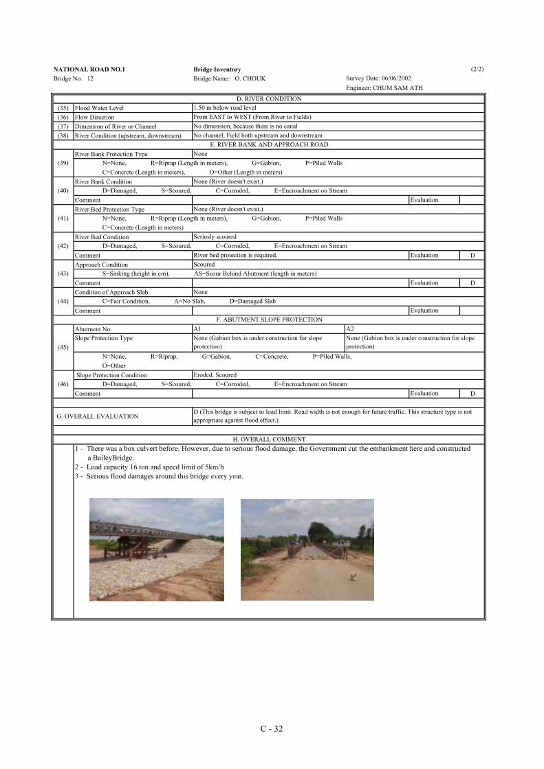
NATIONAL ROAD NO.1 Bridge InventoryBridge No. 12 Bridge Name: O. CHOUK
(35) Flood Water Level(36) Flow Direction(37) Dimension of River or Channel(38) River Condition (upstream, downstream)
River Bank Protection Type
River Bank Condition
CommentRiver Bed Protection Type
River Bed Condition
Comment DApproach Condition
Comment DCondition of Approach Slab
Comment
Abutment No.Slope Protection Type
Slope Protection Condition
Comment D
D. RIVER CONDITION1.50 m below road levelFrom EAST to WEST (From River to Fields)
Survey Date: 06/06/2002Engineer: CHUM SAM ATH
No dimension, because there is no canalNo channel, Field both upstream and downstream
E. RIVER BANK AND APPROACH ROAD
(39)None
N=None, R=Riprap (Length in meters), G=Gabion, P=Piled Walls C=Concrete (Length in meters), O=Other (Length in meters)
(40)None (River doesn't exist.)
D=Damaged, S=Scoured, C=Corroded, E=Encroachment on StreamEvaluation
(41)None (River doesn't exist.)
N=None, R=Riprap (Length in meters), G=Gabion, P=Piled Walls C=Concrete (Length in meters)
(42)Seriosly scoured
D=Damaged, S=Scoured, C=Corroded, E=Encroachment on StreamRiver bed protection is required. Evaluation
(43)Scoured
S=Sinking (height in cm), AS=Scour Behind Abutment (length in meters)Evaluation
(44)None
C=Fair Condition, A=No Slab, D=Damaged SlabEvaluation
F. ABUTMENT SLOPE PROTECTION
(45)
A1 A2None (Gabion box is under construction for slopeprotection)
None (Gabion box is under construction for slopeprotection)
N=None, R=Riprap, G=Gabion, C=Concrete, P=Piled Walls, O=Other
(46) D=Damaged, S=Scoured, C=Corroded, E=Encroachment on StreamEvaluation
Eroded, Scoured
G. OVERALL EVALUATIOND (This bridge is subject to load limit. Road width is not enough for future traffic. This structure type is notappropriate against flood effect.)
H. OVERALL COMMENT1 - There was a box culvert before. However, due to serious flood damage, the Government cut the embankment here and constructed a BaileyBridge.2 - Load capacity 16 ton and speed limit of 5km/h3 - Serious flood damages around this bridge every year.
(2/2)
C - 32
(1) Structure No.(3) Station(5) Structure Type(7) Length (meter) as a road(9) Width (meter) as a road(10) Number of Lanes(12) Load Limit ( tf )
(14) Number of Opening (With/without Gate)(15) Opening Dimension
Pavement Condition
Comment CTop Slab Condition
Comment DWall and Bottom Slab Condition
Comment CGuardrail Type
Guardrail Condition
Comment C(21) Foundation Type
Foundation Condition
Comment B
(23) Bearing TypeBearing Condition
CommentBearing Seat Condition
Comment(26) Expansion Joint Type
Expansion Joint Condition
CommentFalling Prevention Condition None
Comment Wing Wall Condition C W
Comment B
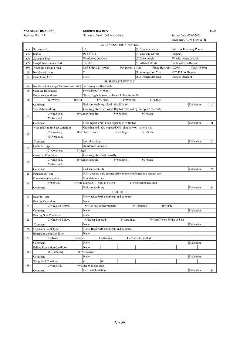
NATIONAL ROAD NO.1 Structure Inventory (1/2)Structure No.: 13 Structure Name: Old Water Gate Survey Date: 07/06/2002
Engineer: CHUM SAM ATH
A. GENERAL INFORMATION13 (2) Structure Name Prek Bak Kampong PhnomPk 50+015 (4) Crossing Object ChannelReinforced concrete (6) Skew Angle 90º with center of road12.30m (8) Affixed Utility Cable optic on the slabLeft Sidewalk= 0.00m Pavement= 5.80m Right Sidewalk= 0.00m Total= 5.80m2 (11) Completion Year 1976 Pol Pot RegimeNone (13) Design Standard Chinese Standard
B. SUPERSTRUCTURE3 Openings without Gate(W=2.10m, H=4.00m)
(16)Wave, Big hole covered by steel plate for traffic
W=Wave, R=Rut, C=Crack, P=Pothole, O=OtherBad serviceability, Need rehabilitation Evaluation
(17)
Cracking, Rebar exposed, Big hole covered by steel plate for traffic C=Cracking, R=Rebar Exposed, S=Spalling, SC=Scale X=Repaired
Need repair work, Load capacity is restricted Evaluation
(18)
Cracking and rebar exposed, Gun shot hole on bottom slab C=Cracking, R=Rebar Exposed, S=Spalling, SC=Scale X=Repaired,
Less durability Evaluation
(19)Reinforced concrete
C=Concrete, S=Steel
(20)
Cracking, Repaired partially C=Cracking, R=Rebar Exposed, S=Spalling, SC=Scale X=Repaired,
Bad serviceability EvaluationR.C (Because only ground slab can see and foundation can not see)
(22)Foundation scoured
S=Settled, E=Pile Exposed - Height in meters, F=Foundation ScouredBad serviceability Evaluation
C. OTHERSNone, Rigid with abutments and columns
(24)None
C=Cracked Below, N=Not Positioned Properly, D=Defective, R=RustyNone Evaluation
(25)None
C=Cracked Below, R=Rebar Exposed, S=Spalling, W=Insufficient Width of SeatNone EvaluationNone, Rigid with abutments and columns
(27)None
R=Rusty, L=Loose, U=Uneven, C=Concrete SpalledNone Evaluation
(28) D=Damaged, N=No deviceNone Evaluation
(29) C=Cracked, W=Wing Wall ScouredNeed rehabilitation Evaluation
C - 34

(30) Flood Water Level(31) Flow Direction(32) Dimension of River or Channel(33) River Condition (upstream, downstream)
River Bank Protection Type
River Bank Condition
Comment CRiver Bed Protection Type
River Bed Condition
Comment CApproach condition
Comment ACondition of Approach Slab
Comment
No.Slope Protection Type
Slope Condition
Comment B
NATIONAL ROAD NO.1 Structure Inventory (2/2)Structure No.: 13 Structure Name: Old Water Gate Survey Date: 07/06/2002
Engineer: CHUM SAM ATH
D. RIVER CONDITION1.50 m below road levelFrom EAST to WEST (From River to Fields)Upstream: (4.5+8.5) x 2.5, Downstream: (7.5+13.0) x 2.0Damaged on both upstream and downstream
E. RIVER BANK AND APPROACH ROAD
(34)None
N=None, R=Riprap (length in meters), G=Gabion,Box C=Concrete (length in meters), P=Piled Walls
(35)Damaged, corroded, encroachment on stream
D=Damaged, S=Scoured, C=Corroded, E=Enchroachment on Stream Evaluation
(36)None
N=None, R=Riprap (length in meters), G=Gabion, C=Concrete (length in meters) P=Piled Walls
(37)Damaged
D=Damaged, S=Scoured, C=Corroded, E=Enchroachment on Stream Bad serviceability, Dirty surface Evaluation
(38)Good
S= Sinking (height in cm), AS=Scour Behind Abutment (length in meters) Evaluation
(39)None
C=Fair Condition, A=No Slab, D=Damaged SlabEvaluation
F. ABUTMENT SLOPE PROTECTION
(40)
A1 A2None None
N=None, R=Riprap, G=Gabion, C=Concrete, P=Piled Walls
(41)Damaged
D=Damaged, S=Scoured, C=Corroded, E=Enchroachment on Stream Protection required Evaluation
G. OVERALL EVLUATION D (Not enough on durability and serviceability)
H. OVERALL COMMENT1- This Water Gate is an old structure which was constructed in the Pol Pot Regime for irrigation drainage to the rice field and also flood emergency protection in the rainy season. 2- Slab of structure was gun shoting hole, now close by steel plate.3- Upstream small canal presents only in flood seasons.
C - 35


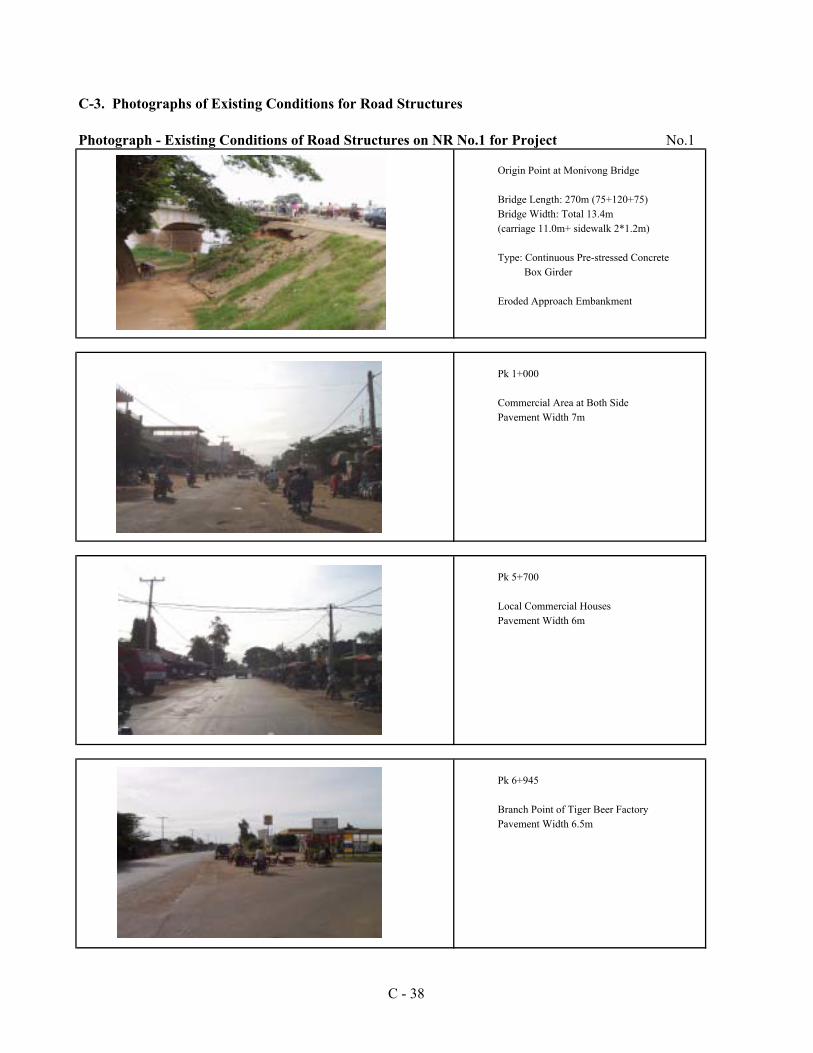
C-3. Photographs of Existing Conditions for Road Structures
Photograph - Existing Conditions of Road Structures on NR No.1 for Project No.1
Origin Point at Monivong Bridge
Bridge Length: 270m (75+120+75)Bridge Width: Total 13.4m(carriage 11.0m+ sidewalk 2*1.2m)
Type: Continuous Pre-stressed Concrete Box Girder
Eroded Approach Embankment
Pk 1+000
Commercial Area at Both SidePavement Width 7m
Pk 5+700
Local Commercial HousesPavement Width 6m
Pk 6+945
Branch Point of Tiger Beer FactoryPavement Width 6.5m
C - 38
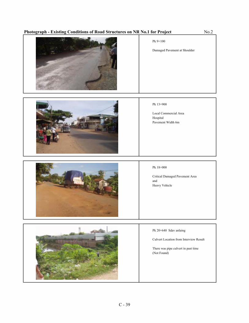
Photograph - Existing Conditions of Road Structures on NR No.1 for Project No.2
Pk 9+100
Damaged Pavement at Shoulder
Pk 13+900
Local Commercial AreaHospitalPavement Width 6m
Pk 18+000
Critical Damaged Pavement AreaandHeavy Vehicle
Pk 20+640 Sdav anlaing
Culvert Location from Interview Result
There was pipe culvert in past time(Not Found)
C - 39
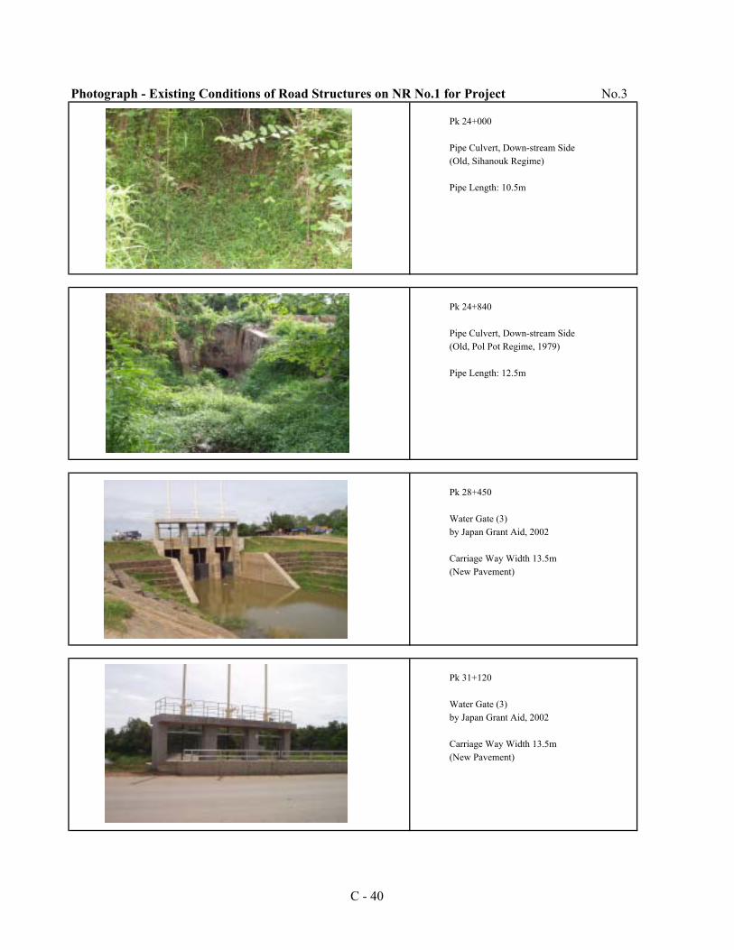
Photograph - Existing Conditions of Road Structures on NR No.1 for Project No.3
Pk 24+000
Pipe Culvert, Down-stream Side(Old, Sihanouk Regime)
Pipe Length: 10.5m
Pk 24+840
Pipe Culvert, Down-stream Side(Old, Pol Pot Regime, 1979)
Pipe Length: 12.5m
Pk 28+450
Water Gate (3)by Japan Grant Aid, 2002
Carriage Way Width 13.5m(New Pavement)
Pk 31+120
Water Gate (3)by Japan Grant Aid, 2002
Carriage Way Width 13.5m(New Pavement)
C - 40
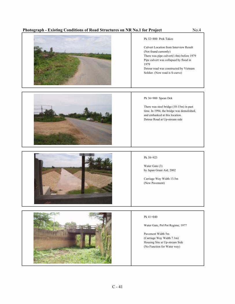
Photograph - Existing Conditions of Road Structures on NR No.1 for Project No.4
Pk 32+800 Prek Takeo
Culvert Location from Interview Result(Not found currently)There was pipe culvert(1.0m) before 1979Pipe culvert was collapsed by flood in1979Detour road was constructed by VietnamSoldier. (Now road is S-curve)
Pk 36+900 Spean Dek
There was steel bridge (10-15m) in past time. In 1994, the bridge was demolished,and embanked at this location.Detour Road at Up-stream side
Pk 38+923
Water Gate (3)by Japan Grant Aid, 2002
Carriage Way Width 13.5m(New Pavement)
Pk 41+040
Water Gate, Pol Pot Regime, 1977
Pavement Width 5m(Carriage Way Width 7.1m)Housing Site at Up-stream Side(No Function for Water way)
C - 41
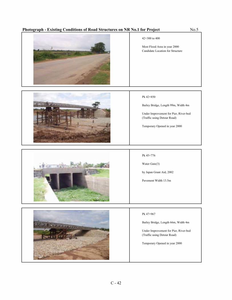
Photograph - Existing Conditions of Road Structures on NR No.1 for Project No.5
42+300 to 400
Most Flood Area in year 2000Candidate Location for Structure
Pk 42+850
Bailey Bridge, Length 99m, Width 4m
Under Improvement for Pier, River-bed(Traffic using Detour Road)
Temporary Opened in year 2000
Pk 45+776
Water Gate(3)
by Japan Grant Aid, 2002
Pavement Width 13.5m
Pk 47+967
Bailey Bridge, Length 66m, Width 4m
Under Improvement for Pier, River-bed(Traffic using Detour Road)
Temporary Opened in year 2000
C - 42
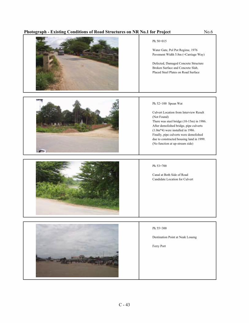
Photograph - Existing Conditions of Road Structures on NR No.1 for Project No.6
Pk 50+015
Water Gate, Pol Pot Regime, 1976Pavement Width 5.8m (=Carriage Way)
Defected, Damaged Concrete StructureBroken Surface and Concrete Slab,Placed Steel Plates on Road Surface
Pk 52+100 Spean Wat
Culvert Location from Interview Result(Not Found)There was steel bridge (10-15m) in 1986.After demolished bridge, pipe culverts(1.0m*4) were installed in 1986.Finally, pipe culverts were demolisheddue to constructed housing land in 1999.(No function at up-stream side)
Pk 53+700
Canal at Both Side of RoadCandidate Location for Culvert
Pk 55+300
Destination Point at Neak Loueng
Ferry Port
C - 43
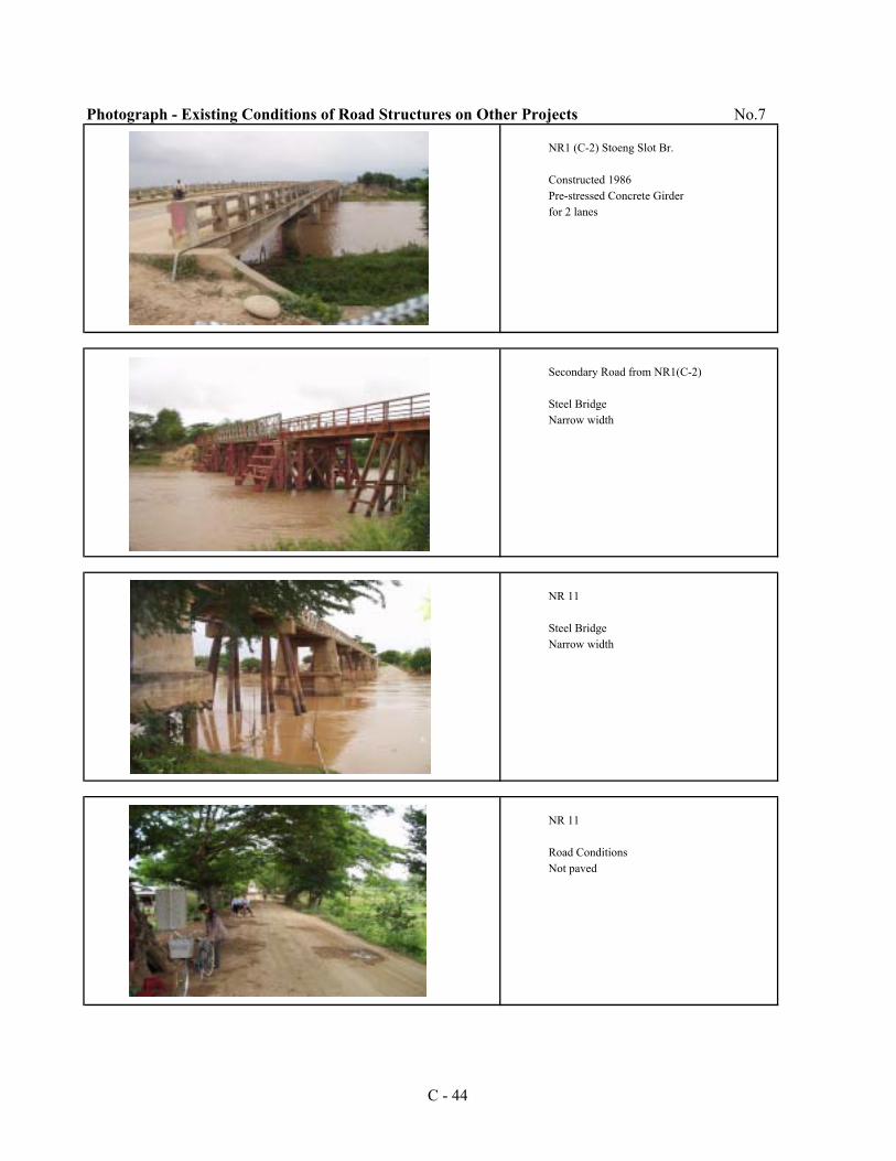
Photograph - Existing Conditions of Road Structures on Other Projects No.7
NR1 (C-2) Stoeng Slot Br.
Constructed 1986Pre-stressed Concrete Girderfor 2 lanes
Secondary Road from NR1(C-2)
Steel BridgeNarrow width
NR 11
Steel BridgeNarrow width
NR 11
Road ConditionsNot paved
C - 44
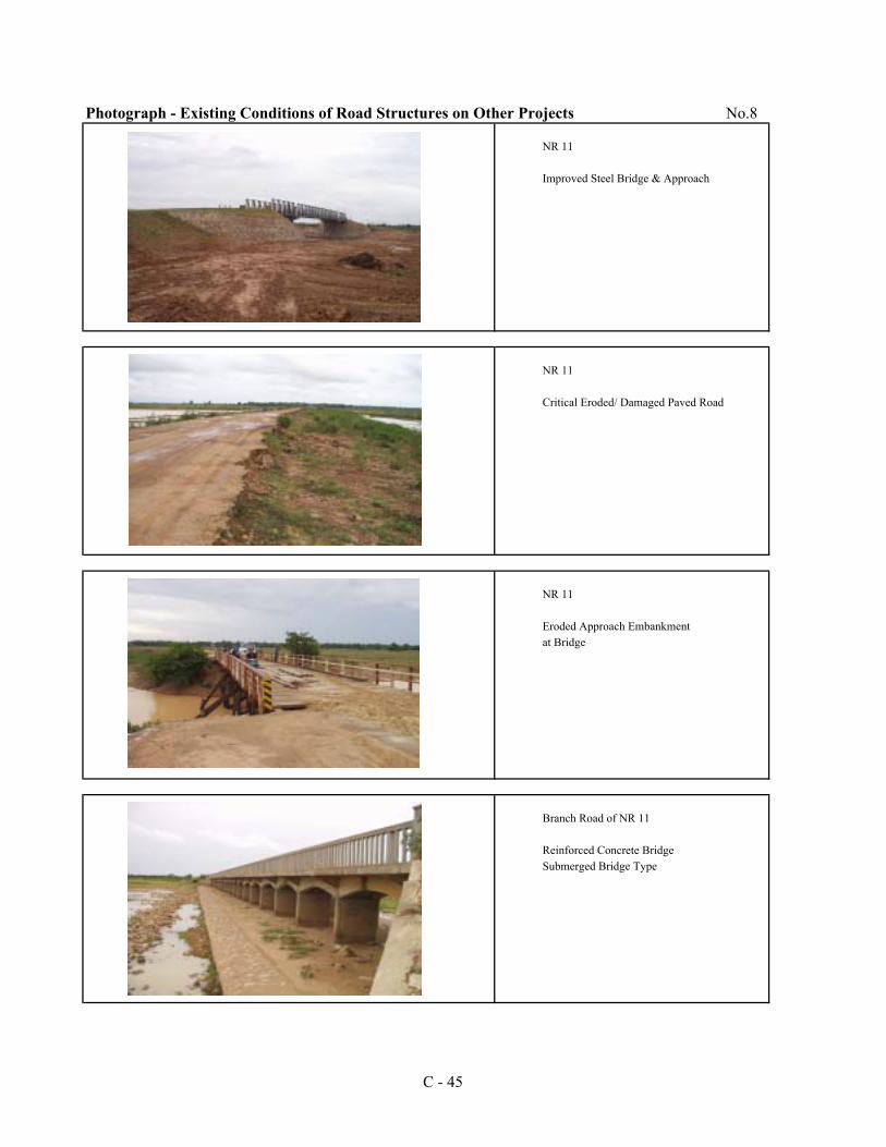
Photograph - Existing Conditions of Road Structures on Other Projects No.8
NR 11
Improved Steel Bridge & Approach
NR 11
Critical Eroded/ Damaged Paved Road
NR 11
Eroded Approach Embankmentat Bridge
Branch Road of NR 11
Reinforced Concrete BridgeSubmerged Bridge Type
C - 45
C - 46
C-4. Study on Girder Structure above Piers
Proposed bridge has PC I-shaped girder for superstructure. It could be spliced above piers or left as simple girder as it is. Method to splice the girders is by cast-in-situ RC with PC cable crosswise. This appendix compares features between simple girder and splice girder for the project.
Conditions for the comparison are shown below: - Main girder has same structure (length, height, width etc.) in both methods. - Bearing is same in both methods. It will be rubber pad bearing. - Horizontal force against earthquake and temperature are supported by only one pier of the Splice
Girder Bridge. - Splice girder needs to be calculated with statistically indicated force (creep, shrinkage etc.) - Method to splice girder is by cast-in-situ RC with PC cable crosswise. - Splice girder can be considered as continuous girder after the splice work is done. Loading for
designing differs in splice girder. Main dead load (main girder, cross beam, slab etc.) - Cost estimation is done on bridge No.2 (L = [email protected] meters)
Features in both methods are described in the table below. Simple Girder Splice Girder
Structure
Each girder is individual. Each girder is supported by move and fix bearings Expansion joint is required between girders.
Girders are spliced and surface is continuous. Supported by rubber pad bearings. Anchor bar adjusts the movement. All girders are supported on one pier horizontally. Expansion joint is not required between girders.
Designing Loading as simple beam
Loading as simple beam before splicing Loading as continuous beam after splicing. Dead load (girder, cross beam, slab etc.): simple beam Dead load (pavement, splice cross beam): continuous girder Live load : continuous girder Statistically indicated force is loaded.
Ease of construction
Installing expansion joint is required. Extra pre-stressed cable work is required for splicing
(Crosswise above piers) Construction
cost US$ 1,801,800 / bridge US$ 1,806,500 / bridge
Construction Period
Slightly shorter Slightly longer
Ease of Maintenance
Maintenance of expansion joint is required.Easy, no maintenance of expansion joint above piers is
required. Smoothness of surface
Not good for expansion joint Very good
Environmental aspect
Noise and vibration on expansion joint Quite and sound
Evaluation Not good Good
It can be concluded that the splice girder has superior system for the project road, especially after the completion of construction. No requirement for expansion joint can save maintenance fond and make vehicles comfortable to run across.