Embed Size (px)
Citation preview

9
SUPERIOR
LAKE
Amity
Cre ek
Le t
er
Cr
Tischer
Cr
Skyl
ine
Park
way
WEST TISCHER RD
JEA
N
DU
LUTH
R
D.
Arnold
280
G 241
252
C.J. Ramstad/ North Shore State Trail
inset 1
10 SEE INSET
s
Hawk Ridge
DULUTH 12 37
Hartley Park
23
61
U of MN -Duluth C.J. Ramstad/ 37North Shore
State Trail M
252
280 Amity Park G
MARTIN RD. 10
DULUTH
River Track Devil H I K I N G
T R A I L
Track
Devil River
S U P E R I O R
inset PAT BAYLE 4 STATE FOREST Gunflint
Trail
8
Devil Track Lake
18
C.J. Ramstad/North MonkerShore State Trail
Lake
8
P Little
7.2 SUPERIOR
6 NATIONAL
FOREST 7
Grand Marais 61 G, M, L, S
Baptism
River Lindstrom
River
7FINLAND 7.2
STATE FOREST
C.J. Ramstad/North Shore State Trail
Leskinen LakeFinland 6
1
4
inset 3
Tettegouche State Park
Distan
ce in M
iles
Grand Marais
Lutsen
Caribou Parking
Sawbill Parking
Schroeder Ely Isabella
Tomahawk Jct.
Finland Silver Bay
Two Harbors Pking.
Pequayan Tr. Jct.
French Ri. Parking
Duluth & Parking 26 ovland
8 28
14 17 41
14 27 31 55 ark 74 78 91 95 119
8039 35 39 52 56
24 63 11 15 28 32 56
20 44 83 31 35 48 52 76
17 37 61 100 48 52 65 69 93
34 37 57 81 102 68 72 85 89 113
21 55 58 78 102 141 89 93 106 110 133
5 26 60 63 83 107 146 94 98 111 115 139
14 19 40 74 77 97 121 160 108 112 125 129 153
River
Silver Creek
C.J. Ramstad/North Shore State Trail inset G, M 2
Stewart 201
Stewart
SUPERIOR HIKING TRAIL
12
3 2
Harbors CorridorTwo
12 61 Trail
11 Two Knife Harbors River
G, M, L, S
2
G R A N D
L A K E
S U P E R I O R
Swamp River
River
River
Track
Little Devil T rack River
Brule
Flute
Reed
P O R T A G E
S T A T E
F O R E S T
Devil
River
Cascade
Deer Ya
rd Lake
Pike L ake
Pigeon
River
L
Tom Lake
S U P E R I O R
N A T I O N A L
F O R E S T
P A T
B A Y L E
F O R E S T
G r a n d P o r t a g e
I n d i a n R e s e r v a t i o n
S U P E R I O R
H I K I N G
T R A I L
S T A T E Elbow
Lutsen Tra i l
Gunflint Trai
Lutsen
SUPERIOR
HIKING
TRAIL
Caribou
Poplar
River
Po pl
ar
Rive
r
Temperance
River
Temperance
Blind
Lake
Lutsen Tr.
Trail
Tofte
Trail
Creek
Sixm
ile
Mist
letoe
Cr.
Trai
l G
unfli
nt
AREA POLICE DEPARTMENTS: AREA INFORMATION: EMERGENCY INFORMATION: MEDICAL/ HOSPITALS:
Grand Marais: 218-387-3030
Two Harbors: 218-834-5566
Silver Bay: 218-226-4486
Duluth: 218-727-8770
Visit Duluth 218-722-4011 or 1-800-438-5884 visitduluth.com
Two Harbors Chamber of Commerce 218-834-2600 twoharborschmber.com
Cook Co. Sheriff: 218-387-3030
Lake Co. Sheriff: 218-834-8385
St. Louis Co. Sheriff: 218-726-2360
State Patrol: 218-723-4888
IN AN EMERGENCY, CALL 911 DULUTH St. Mary’s: 218-726-4000 St. Luke’s: 218-726-5555
TWO HARBORS Lake View Memorial: 218-834-7300
SILVER BAY Bay Area Health Center: 218-226-4431
GRAND MARAIS Cook Co. North Shore: 218-387-3040
Silver Bay - Beaver Bay Area Chamber 1-800-777-7384 (Two Harbors #)DNR CONSERVATION OFFICERS:
Grand PortageHeart of the Arrowhead Association218-353-7359
Duluth: 218-525-2800 CANAD A State Park218-729-9675 218-525-6024218-729-6579 Lutsen - Tofte Tourism Association
218-663-7804 or 1-888-616-6784 218-624-5703 218-729-4994 61north.com
Two Harbors: 218-834-4653 Grand Marais Visitor Center218-387-2524 or 1-888-922-5000 218-834-1406
Grand Portage
218-360-1175 grandmaraismn.com 16
Tofte: 218-663-7183
Grand Marais: 218-387-9751 218-475-0121
17
Mineral Center
Northern 17 61 Light Lake
12 TroutLake 16
TOURISM INFORMATION: (Local snowmobile maps available)H
Visit Duluth 21 West Superior Street Suite 100Duluth, MN 55802800-4DU-LUTH218-722-4011
14
l 8 Kodonce RiverDevil Track Lake State Wayside
Park 61 Judge C.R. Magney State P18
Monker
visitduluth.comLake
Croftville Devils Track Falls
State Wayside Park
9.8 8 12 P Two Harbors Chamber of Commerce
RJ Houle Information Center1330 Highway 61 Two Harbors, MN 55616 800-777-7384218-834-6200 (visitor information) 218-834-2600 (for the chamber direct)
Turtle Lake4
Mark Lake HollyLake 6
7.2 Lake Clara
7.6 Mistletoe
Lake 7 inset Grand Marais
Halls Pond twoharborschamber.com4White G, M, L, S
Pine PVat L Silver Bay Chamber
Box 26 Silver Bay, MN 55614 800-777-7384 (Two Harbors)
Lake River 7 61
silverbay.com4.6mi.
Grand Marais ChamberPO Box 1048Grand Marais, MN 556041-888-922-5000 218-387-2524
Cascade River State Park WARM SEASON USERS: Since you will travel through remote, forested country side, you should take a map, a compass, extra food, clothing and water. Tell someone where you are going and when you will be back. During insect season, be prepared for usual Northwoods conditions.
Fall colors are usually quite spectacular because the Trail follows maple coveredridges. Birch/Aspen stands are also widespread.
M, L N Barker Lake
Lutsen grandmarais.comTrail Fishing enthusiasts will find the Trail a good walk-in access to remote, lightly fishedstreams. Since 95% of the land is for public use, hunters can also pursue their sport usingthe trail as a walk-in access to many areas.
4 M, L
9.7mi. A 6.6 mile portion of the C. J Ramstad/North Shore State Trail is now open for ATV use. This portion connects with 60 miles of GIAATV trails.
36 LLutsenutsen FOR MORE INFORMATION:G, M, LG, M, L
DNR Parks and Trails Area OfficeWINTER USERS: The same safety and logistical suggestions apply to winter users, except that the need to protect ones self from the cold is obvious.The trail is groomed for snowmobiling in its entirety on a weekly basis. Stay on the trailor intersecting trails at all times. Use caution in the vicinity of active logging operations. Plan ahead for refueling.
218-834-1431 (office)61 The portion suggested for summer hiking
and horseback riding is from the town of Finland to Cook Co. Rd. #6, north of Grand Marais, approximately 70 miles. The trail between Finland and Duluth is hikeable but occassional wet areas may be encountered.
218-834-1439 (trail conditions)Ray Berglund
Information CenterMinnesota Department of Natural Resources Information Center Box 40500 Lafayette Rd.St. Paul, MN 55155651-296-61571-888-MINNDNR
State Wayside Park
Camping is suggested at the trail shelters along the trail. Camping is also allowed onadjacent public land except where posted asprohibited. Respect all private property signsas well as other restriction signs that may be posted. The rest of the trail may be hiked,but the visitor should be ready to cross or avoid wet areas which make for hard travel.Topographic quadrangles can be obtained for all areas the trail traverses, although older versions may not show modern trail alignment.
Lynx Trail Tofte
G,M,L,S Check out the DNR’s website for moreinformation regarding accessible recreational Temperance River
State Park opportunities. mndnr.gov
C. J Ramstad/North Shore State Trail DNR Parks and Trails 1568 Highway 2Two Harbors, MN 55616 218-834-1430218-834-1439updated trail condition messageduring winter season
Schroeder G,M,L
UNITED STATES NATIONAL GRID (USNG) EMERGENCY SIGNS
USNG emergency signs areposted along the trail, andshould be used as alocation reference when calling 911.
Since the trail is used for snowmobiling inwinter, hikers can stay on the trail by following periodic snowmobile trail signs. These consist of chiefly State Trail and No Motorized vehicle signs, directional arrowsand small diamond shaped orange blazers ontrees and posts. In places the Trail follows back-country roads for distances. These too are posted with the above mentioned signsand blazers. Since the trail goes throughforested areas, logging activities will periodically be taking place. Use caution when travelling these areas.
NOTE:
Some private lands exist within the shaded areas shown for state forest & state park lands.
mndnr.gov/state_trails
Superior Hiking Trail Association P.O. Box 4731 7th AvenueTwo Harbors, MN 55616218-834-2700
Please be aware of your surroundings.
shta.org
2
Superior Hiking Trail
TRAILS AND THEIR PERMITTED USES
C. J. Ramstad/North Shore State Trail
C. J. Ramstad/North Shore State Trail
Other Snowmobile Trails
Snowmobile/ATV combined
ATV Only
S
0 1 2 3 4 5 Miles
0 1 2 3 4 5 Kilometers
MAP KEY
RAIL SYMBOLS FACILITIES
G Gasoline Parking
M Meals
Campground L Lodging
S Snowmobile Shelter-Campsite
Repair
P Summer Parking Shelter
Walk-in Campsite
Snowmobile
ATV
Hiking
Cross Country Ski
Horseback
Scenic Overlook
Distance Marker
COOK CO.
C. J. Ramstad/North Grand Marais Shore Trail
ST. LOUIS COUNTY LAKE
COUNTY
Duluth
Minneapolis
St. Paul
Beaver
River
Split
Rock
River
River
River
Stewar t
Knife
Rive
r
Sucker
River French
River
Lester
River
L A K E
S
U P E R I O R
Lieuna L ake
Smith L ake
P equaywan L ake
KingL ake
Cloquet
River
A m i t y C r
Knife River
West Branch
S i l v e r C r eek
Encampment R .
Dago
Creek
Mink
Creek
Skunk Cr eek
East Split Rock River
Creek
Thir t y n i n e C r eek
Island G
ooseberry
Kit
West
Split
River
Caribou
E
A K
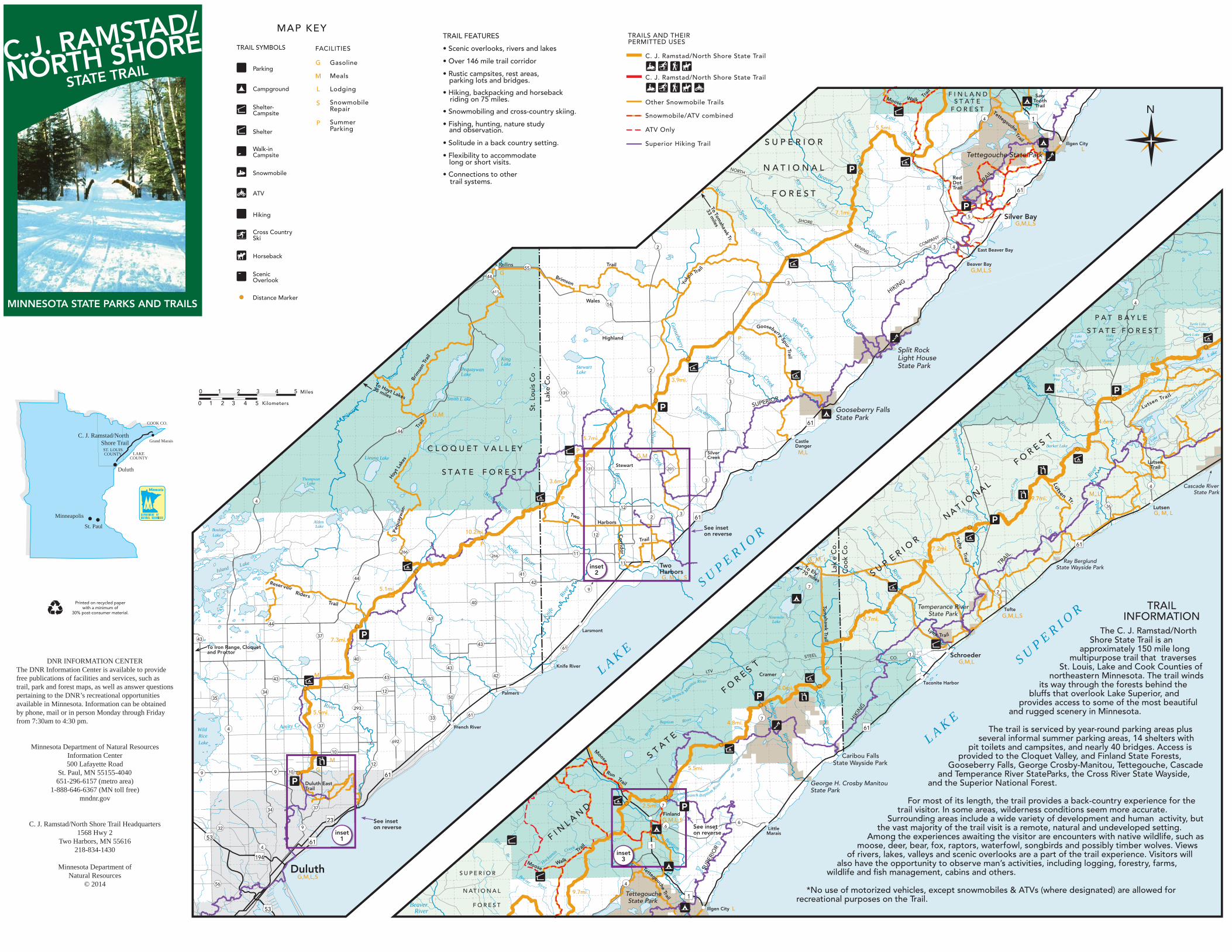
S U P E R I The C. J. Ramstad/NorthShore State Trail is an
approximately 150 mile long multipurpose trail that traverses
St. Louis, Lake and Cook Counties ofnortheastern Minnesota. The trail winds
its way through the forests behind the bluffs that overlook Lake Superior, and
provides access to some of the most beautiful and rugged scenery in Minnesota.
O R
Poplar
River
P opl
ar
Rive
r
T emperance
River
River
Cross
Two
Island
River
Caribou River
Manitou
River
River
Eas t B r a n c B a p tism Rive
r
S o u t h B r a n c h Man
ito u R i v
m i l e
C r e
ek
Mist
letoe
Cre
ek
T e m p e ran c e
B lind
Lake
River
East
Bran
ch
Deer Yard Lake
P ike L ake
Beaver
Br.
East
Hockamin Cr eek
Baptism
River
Rock
River
East
Branch Beaver
L ake
Reser voir Riders
Trail
S U P
N AT I O
N A L
F O R E S T
TRAIL
Lutsen Tr.
Trail
Tofte
Lutsen Tra i l
Coo
k C
o .
Lak
e C
o.
S T A T E
F O R E S T
LTV
STEEL
HIKIN
G
Lynx Trail
To Ely70 miles
Tom
ahaail
SUPE
RIO
R
F I N L
A N D
Tettegouche Trail
RunTrail
Moose
Moose Walk
Trail
Brim
son
Trai
l
Peq
uayw
an-
Trai
l
Hoy
t Lak
es
To Ho35 milesyt Lakes
MINING
SUPERIOR
Trail
Yuko
n Trail
Brimson
Trail
Co
rrido
r
Two
SHORE
COMPANY
NORTH
Tettegouche
HIKING
TRAIL
Walk Tr
ail
Moose
Trail
To Tomahaw
k Tr.
33 miles
Gooseberry SpurTrail
L C.J. RAMSTAD/
NORSTATE TRAITH SHORE TRAIL FEATURES
T • Scenic overlooks, rivers and lakes
• Over 146 mile trail corridor
• Rustic campsites, rest areas,parking lots and bridges.
• Hiking, backpacking and horsebackriding on 75 miles.
F I N L A N D Saw
• Snowmobiling and cross-country skiing.S T A T E Tooth
Trail NF O R E S T
1 4 • Fishing, hunting, nature study
and observation.
• Solitude in a back country setting.
5.5mi.
U P E R I O R Illgen City L
Tettegouche State Park• Flexibility to accommodatelong or short visits.
• Connections to othertrail systems.
N A T I O N A LRedDot Trail 61F O R E S T
7.1mi.5 Silver Bay
G,M,L,S
3 42 East Beaver Bay
Beaver Bay G,M,L,S
Rollins 55
G44
3
611 9.4mi.WalesMINNESOTA STATE PARKS AND TRAILS 414
P A T B A Y L E Turtle Lake
S T A T E F O R E S T Mark L akeLake HollyHighland P LakeClara
Split Rock Light House Mistletoe 7.6
LakeState ParkStewart Lake 2
St. L
ouis
Co
.
Lake
Co.
131
White Pine Halls PondP
Vat L 3.9mi. 3
Lake
Gooseberry FallsG,M State Park
4.6mi.6144
Barker L
Lutsen
5.7mi. Castle Danger
Silver M,L ake C L O Q U E T V A L L E Y P
G,M Creek
Stewart Trail2131 201S T A T E F O R E S T Thompson
Lake 33.6mi.
4 Cascade River State ParkM, L
P Six 9.7mi.4
36 Lutsen G, M, L
12 3
612 Alden Lake
Boulder
Harbors See inset on reverse10.2mi.Lake 12
E R I O R
P
P 61 7.2mi.
266 11266 G, M, L
11 Two Harbors G, M, L, S
Ray Berglund State Wayside Parkinset
41 2 44
42
9 75.1mi. 2
40Printed on recycled paper with a minimum of
30% post-consumer material. TRAIL
INFORMATIONTemperance River
w
Tofte State Park G,M,L,SNinemile
Lake 9.7mi.40 44 k
TrLarsmont 37
Schroeder G,M,L
Taconite Harbor
The trail is serL
viced by year-round parking areas plus several informal summer parking areas, 14 shelters with
pit toilets and campsites, and nearly 40 bridges. Access is provided to the Cloquet Valley, and Finland State Forests,
Gooseberry Falls, George Crosby-Manitou, Tettegouche, Cascadeand Temperance River StateParks, the Cross River State Wayside,
and the Superior National Forest.
43 7.3mi. 43
To Iron Range, Cloquet and Proctor
DNR INFORMATION CENTER 40
61 1
CO.
Cramer
Knife RiverThe DNR Information Center is available to provide free publications of facilities and services, such as trail, park and forest maps, as well as answer questions pertaining to the DNR’s recreational opportunities available in Minnesota. Information can be obtained by phone, mail or in person Monday through Friday from 7:30am to 4:30 pm.
43 P M 42
43 43 er
43 4.0mi.1234 Palmers
5035
7 5.9mi.
293
6133
Baptism 4.8mi.37 French River 61Wild 4
Rice 692Lake
Minnesota Department of Natural Resources Information Center 500 Lafayette Road
St. Paul, MN 55155-4040 651-296-6157 (metro area)
1-888-646-6367 (MN toll free)
10Caribou Falls
M State Wayside Park12 5.5mi.G
9 9 10 61 George H. Crosby Manitou
h
Duluth East Trail State Park
mndnr.gov For most of its length, the trail provides a back-country experience for thetrail visitor. In some areas, wilderness conditions seem more accurate.
Surrounding areas include a wide variety of development and human activity, butthe vast majority of the trail visit is a remote, natural and undeveloped setting.
Among the experiences awaiting the visitor are encounters with native wildlife, such asmoose, deer, bear, fox, raptors, waterfowl, songbirds and possibly timber wolves. Views
of rivers, lakes, valleys and scenic overlooks are a part of the trail experience. Visitors will also have the opportunity to observe man’s activities, including logging, forestry, farms,
wildlife and fish management, cabins and others.
2.5mi. 737 34 Finland G,M,L,S23 See inset
9 on reverse32 6C. J. Ramstad/North Shore Trail Headquarters
1568 Hwy 2 Two Harbors, MN 55616
218-834-1430
6 See inset Little inset on reverse Marais
53 161 14
inset 194 3
Minnesota Department of Natural Resources
© 2014
Duluth S U P E R I O RG,M,L,S
456
Tettegouche *No use of motorized vehicles, except snowmobiles & ATVs (where designated) are allowed for recreational purposes on the Trail.
N AT I O N A L 9.7mi. 1
State ParkBeaver F O R E S TIllgen City L53 River