Embed Size (px)
Citation preview

The Study for Broader Area Transport Infrastructure Development in Afghanistan and the Surrounding Countries
2 - 53
2.1.7 Current Status and Issues of Other Peripheral Countries
2.1.7.1 India
(1) Assistance of India to Afghanistan
India has, as a member of the international community, extended assistance to Afghanistan. Just after
the suicide bomb attack at the Indian Embassy in Kabul on July 7, 2008, President Karzai visited
India on August 3-5, 2008. Then, India promised assistance of US$450 million in addition to
US$750 million already committed.
The main contents of Indian assistance to Afghanistan are a 218km road construction project
between Zarang and Dilaram (completed on January 22, 2009) and construction of power
transmission lines between Pul-e-Khumri and Kabul (it was to be completed in April 2009). In
addition, 250 thousand cubic meters of wheat was given for free, and the Indira Gandhi Children’s
Hospital in Kabul was reconstructed.
As education and capacity building projects, India accepts students from Afghanistan, trains 1,000
construction workers, and gives financial assistance to women’s independence and small-scale
development projects.
2.1.7.2 Present Conditions and Issues on Road Transport in India
1) Present Conditions of the International Trunk Road Network in India
A. Present Asian Highway Network in India
Table 2.11 International Trunk Roads in India
Route No.
Itinerary Length (km)
Selection Criteria
AH1 Moreh (border of Myanmar) – Imphal – Nagaon – Dawki (border of Bangladesh)
834 *Connection between Capitals *Connection between Industrial/Agricultural Centers
Bangaon (border of Bangladesh) – Kolkata – Barhi – Kanpur – Agra – New Delhi – Attari (border of Pakistan)
2,036 *Connection between Capitals *Connection between Industrial/Agricultural Centers*Connection between major Ports *Connection between Cargo Terminals
AH2 Border of Bangladesh – Siliguri – Border of Nepal
53 *Connection between Capitals *Connection between Industrial/Agricultural Centers
Banbasa (border of Nepal) – Moradabad – New Delhi
324
AH42 Raxaul (border of Nepal) – Barauni – Nawada – Barhi
457 *Connection between Industrial/Agricultural Centers*Connection between major Ports *Connection between Cargo Terminals
AH43 Agra – Gwalior – Nagpur – Hyderabad – Bangalore – Krishnagiri – Madurai – Dhanushkodi (to Sri Lanka)
2,433 *Connection between Industrial/Agricultural Centers*Connection between Cargo Terminals
AH45 Kolkata – Kharagpur – Bhubaneswar –Visakhapatnam – Vijayawada – Chennai – Krishnagir
1,945 *Connection between Industrial/Agricultural Centers*Connection between major Ports *Connection between Cargo Terminals
AH46 Kharagpur – Raipur – Nagpur – Dhule 1,508 *Connection between Industrial/Agricultural Centers
AH47 Gwalior – Indore – Dhule – Mumbai – Bangalore
2,060 *Connection between Industrial/Agricultural Centers*Connection between major Ports *Connection between Cargo Terminals
Total 11,650
Source: Asian Highway Database 2009, UN ESCAP
The study for Broader Area Transport Infrastructure Development in Afghanistan and the Surrounding Countries
2 - 54
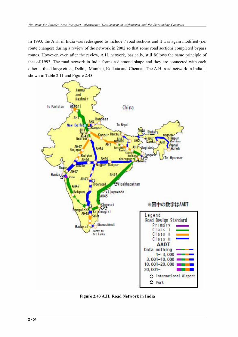
In 1993, the A.H. in India was redesigned to include 7 road sections and it was again modified (i.e.
route changes) during a review of the network in 2002 so that some road sections completed bypass
routes. However, even after the review, A.H. network, basically, still follows the same principle of
that of 1993. The road network in India forms a diamond shape and they are connected with each
other at the 4 large cities, Delhi、Mumbai, Kolkata and Chennai. The A.H. road network in India is
shown in Table 2.11 and Figure 2.43.
Figure 2.43 A.H. Road Network in India
The study for Broader Area Transport Infrastructure Development in Afghanistan and the Surrounding Countries
2 - 54
In 1993, the A.H. in India was redesigned to include 7 road sections and it was again modified (i.e.
route changes) during a review of the network in 2002 so that some road sections completed bypass
routes. However, even after the review, A.H. network, basically, still follows the same principle of
that of 1993. The road network in India forms a diamond shape and they are connected with each
other at the 4 large cities, Delhi、Mumbai, Kolkata and Chennai. The A.H. road network in India is
shown in Table 2.11 and Figure 2.43.
Figure 2.43 A.H. Road Network in India

The Study for Broader Area Transport Infrastructure Development in Afghanistan and the Surrounding Countries
2 - 55
B. Present Asian Highway Network in India
In India, there are A.H roads with various classes from Primary to Class III and the only section
which is identified as primary is the 90km between Panvel and Pune, which is adjacent to Mumbai.
The following explanations show the outline of the A.H. which is called the Golden Quadrangle in
India.
⋅ The road section between Deli and Kolkata is classified as Class II with the exception of some sections near Deli and Kolkata area that are classified as Class I.
⋅ The road section between Deli and Mumbai is classified as Class II with exception of a section near Mumbai that is classified as Class I.
⋅ The road section between Kolkata and Chennai is classified as Class I.
⋅ The road section between Mumbai and Chennai is classified as Class I with the exception of some sections which are classified as Class II.
C. Issues
The road mode carries 85% of all passengers and 65% of all cargo transported and it is identified as
a major transportation mode. The road length reaches 3,300,000 km and it is the second longest
length in the world. However, the road length per population of 1000 remains at only 2.75km, which
is lower than the world average of 6.7 km, hence, the domestic road network does not satisfy the
road transport needs. Particularly, the road capacity is insufficient since the dual carriage way road
network occupies only 14% of the national trunk road and 1% of rural roads. Moreover, the single
carriageway road network still represents 59% of national roads and 22% of rural roads. Hence,
average traveling speed is slow at around 50km/hr.
On the other hand, the Government promotes the Expressway construction/development by the
private sector such as BOT or PPP that reaches approximately 5,600km.
As explained above, there is much difference in terms of road development level, and this creates
unbalanced conditions between the urban and rural areas. This situation is caused by the absolutely
insufficient budget allocation. Some other issues are difficulties in land acquisition for road right of
way and environmental measures.
(3) Present Situation and Issues on Railway Sector
Railways in India are operated and managed by the National Railway of India, under the supervision
of the Ministry of Railways. The number of its employee is 1.4 million; this is the most of any
country in the world. The distribution of the railway network is the largest in the world, 18 million
passengers per day and 2 million tons of freight traffic. The number of stations is 6,900, total
length of the line is 63,000 Km. The gauge is generally 1,676 mm but some railway lines apply
1,000 mm or 767 mm gauge to save construction cost. Both freight and passenger transports are
increasing, income and expenditure has been in surplus in the last ten years. Gross annual profit in
the year 2008 was 134,311 million Rupees, and the ratio of passenger and freight transport is 3 to 7.
The Study for Broader Area Transport Infrastructure Development in Afghanistan and the Surrounding Countries
2 - 55
B. Present Asian Highway Network in India
In India, there are A.H roads with various classes from Primary to Class III and the only section
which is identified as primary is the 90km between Panvel and Pune, which is adjacent to Mumbai.
The following explanations show the outline of the A.H. which is called the Golden Quadrangle in
India.
⋅ The road section between Deli and Kolkata is classified as Class II with the exception of some sections near Deli and Kolkata area that are classified as Class I.
⋅ The road section between Deli and Mumbai is classified as Class II with exception of a section near Mumbai that is classified as Class I.
⋅ The road section between Kolkata and Chennai is classified as Class I.
⋅ The road section between Mumbai and Chennai is classified as Class I with the exception of some sections which are classified as Class II.
C. Issues
The road mode carries 85% of all passengers and 65% of all cargo transported and it is identified as
a major transportation mode. The road length reaches 3,300,000 km and it is the second longest
length in the world. However, the road length per population of 1000 remains at only 2.75km, which
is lower than the world average of 6.7 km, hence, the domestic road network does not satisfy the
road transport needs. Particularly, the road capacity is insufficient since the dual carriage way road
network occupies only 14% of the national trunk road and 1% of rural roads. Moreover, the single
carriageway road network still represents 59% of national roads and 22% of rural roads. Hence,
average traveling speed is slow at around 50km/hr.
On the other hand, the Government promotes the Expressway construction/development by the
private sector such as BOT or PPP that reaches approximately 5,600km.
As explained above, there is much difference in terms of road development level, and this creates
unbalanced conditions between the urban and rural areas. This situation is caused by the absolutely
insufficient budget allocation. Some other issues are difficulties in land acquisition for road right of
way and environmental measures.
(3) Present Situation and Issues on Railway Sector
Railways in India are operated and managed by the National Railway of India, under the supervision
of the Ministry of Railways. The number of its employee is 1.4 million; this is the most of any
country in the world. The distribution of the railway network is the largest in the world, 18 million
passengers per day and 2 million tons of freight traffic. The number of stations is 6,900, total
length of the line is 63,000 Km. The gauge is generally 1,676 mm but some railway lines apply
1,000 mm or 767 mm gauge to save construction cost. Both freight and passenger transports are
increasing, income and expenditure has been in surplus in the last ten years. Gross annual profit in the year 2008 was 134,311 million Rupees, and the ratio of passenger and freight transport is 3 to 7.

The study for Broader Area Transport Infrastructure Development in Afghanistan and the Surrounding Countries
2 - 56
Figure 2.44 Railway Network in India (Source; Indian Railways)
Railway Facilities (Indian Railway Year Book 2007-2008)
� Line length: 63,237 km
� Number of locomotives: 8,330
� Number of coaches: 47,375
� Number of wagons: 204,304
� Number of stations: 7,025
The Study for Broader Area Transport Infrastructure Development in Afghanistan and the Surrounding Countries
2 - 57
Railway Transport (Indian Railway Year Book 2007-2008)
� Passengers: 6,525 million
� Passenger-Km: 769,956 million
� Tonnage: 734 million
� Ton-Km: 521,993 million
Management Indicator (Indian Railway Year Book 2007-2008)
� Number of Staff: 1,394,500
� Revenue: 717,200 million Rupees
� Expenditures: 544,622 million Rupees
2.1.7.2 Kazakhstan
(1) Present Conditions and Issues on Road Transport in Kazakhstan
A. Present Conditions of International Truck Road Network in Kazakhstan
Kazakhstan is a vast land which is 7 times lager than that of Japan. Kazakhstan is also identified as
the important relay point between Europe and China from the geographical view point, therefore, the
development of the road network in Kazakhstan affects the international transport system in the
region.
Kazakhstan produces plenty of mineral resources such as oil, coal, chrome, silver, tungsten, lead and
zinc. Moreover, the country has active agriculture and livestock farming industries. Those products
and industries require reliable transport modes and the road and railway modes in Kazakhstan have
been taking important rolls as they are expected.
The road network in Kazakhstan has been developed in connection with neighboring countries such
as Russia, Kyrgyz, Uzbekistan and Turkmenistan. A.H.5, 6 and 7 are identified as major
international trunk road sections in the country. In addition, the A.H. road numbers with two digit
numbers are organized as the regional road network. A.H 5 connects between Khorgos, the China
border, and Zhibek Zholy, the Uzbekistan border, via Almaty, Merke, and Symkent. A.H.6 is the
road route which is generally across south Russia but the section between Karakuga and Chistoe
passes in Kazakhstan for about 90km. A.H 7 starts from south in the country and branches from
A.H.5 at Merke and goes north via Burybaital, Balkhash, Karaganda, Astana, Zhaksy and Kustanai,
and reaches Kaerak, and the Russian border eventually. A.H.7 crosses with A.H.6 in Russia as well.

The study for Broader Area Transport Infrastructure Development in Afghanistan and the Surrounding Countries
2 - 58
Table 2.12 International Trunk Roads in Kazakhstan
Route No.
Itinerary Length (km)
Selection Criteria
AH5 Khogors (border of China) – Koktal – Almaty – Kordai (border of Kyrgyz)
557 *Connection between Capitals *Connection between Industrial/Agricultural Centers
Merke (boder of Kyrgyz) – Shymkent – Zhibek Zholy (border of Uzbekistan)
474 *Connection between Cargo Terminals
AH6 Karakuga (border of Russia) – Petroparlovsk – Chisote (border of Russia)
190 *Connection between Capitals *Connection between Industrial/Agricultural Centers*Connection between Cargo Terminals
AH7 Kaerak (border of Russia) – Kostanai – Ruzayevka – Zhaksy – Astana – Karaganda – Burubaital – Merke
1,981 *Connection between Capitals *Connection between Industrial/Agricultural Centers*Connection between Cargo Terminals
AH60 Pnirtyshshkoe (border of Russia) – Pavlodar – Semipalatinsk – Taskesken – Ucharal – Saryozek – Almaty – Burubaital
1,928 *Connection between Industrial/Agricultural Centers*Connection between Cargo Terminals
AH61 Kordai – Merke 150 *Connection between Industrial/Agricultural Centers
Shymkent – Aralsk – Karabutak – Ural’sk – Kamenka (border of Russia)
2,062 *Connection between Cargo Terminals
AH62 Petropavlovsk – Zhezkazgan – Kyzylorda
1,363 *Connection between Industrial/Agricultural Centers
AH63 Pogodaevo (border of Russia) – Ural’sk – Atyrau – Dossor – Beyneu – Border of Uzbekistan
1,052 *Connection between Industrial/Agricultural Centers*Connection between Cargo Terminals
AH64 Krasny Aul (border of Russia)– Semipalatinsk
111 *Connection between Industrial/Agricultural Centers
Pavlodar – Shiderty – Astana – Kokshetau – Petropavlovsk
887
AH67 Bakhty – Taskesken 187 *Connection between Industrial/Agricultural Centers
Shiderty – Karaganda – Zhezkazgan 753
AH68 Dostyk (border of China) – Ucharal 184 *Connection between Industrial/Agricultural Centers
AH70 Kotyaevka (border of Russia) – Atyrau 277 *Connection between Industrial/Agricultural Centers
Beyneu – Zhetybai – Aktau – Zhanaozen – Border of Turkmenistan
700 *Connection between major Ports
Total (11 Routes) 12,856
Source: Asian Highway Database 2009, UN ESCAP
B. Present Asian Highway Network in Kazakhstan
In Kazakhstan, there are A.H. roads with various classes from Primary to Class III. Generally, the
class of roads are either Class II or III except the Class I road near the old capital Almaty. The
followings are explanations of the current situation of A.H. in the country.
- As for A.H.5, the road section between Khorgos and Almaty has either dual carriageway or
single carriageway and classification depends on the sections which are also either Class II or III.
The section between Almaty and Merke is also the same as the above. The section between
Merke and Symkent generally has a single carriageway and its class is varied either Class II or
III.
- As for A.H.7, the road section between Merke~Burybaital in the south of the country is
classified as Class III and the section between Burybaital and Karaganda is Class II. The section
between Karaganda and Astana is Class II (partially Class I) and the section between Astana and
the Russian border is either Class II or III.

The Study for Broader Area Transport Infrastructure Development in Afghanistan and the Surrounding Countries
2 - 59
Figure 2.45 A.H. Road Network in Kazakhstan
C. Issues
The greatest issue of the road sector in Kazakhstan is also insufficient road maintenance. Most of the
network was constructed during the era of the Soviet Union and almost half of the roads are
considered to require drastic rehabilitation works. Regarding the trunk roads across the country,
large scale rehabilitation work such as widening to dual carriageway has been carried out since the
traffic volume increased rapidly. However, the road sections in rural areas are not focused on for
such rehabilitation because the contribution to economic development is considered to be slight.
Hence, there is a huge gap in terms of development level between urban and rural areas that creates
gaps in living standards between the areas.

The study for Broader Area Transport Infrastructure Development in Afghanistan and the Surrounding Countries
2 - 60
(2) Present Situation and Issues on Railway Sector
Railways in Kazakhstan are developed, operated and managed by a Joint Stock Company of
Kazakhstan Temir Zholy (KTZ), established in 1894. There are 22 joint stock companies for
railway related projects; KTZ takes a leading position in these companies. The gauge is 1,520 mm,
total length is 13,579 Km and 3,811 Km of it is electrified, 4,706 Km is double- tracked. Major
articles of the freight transport are the Kazakhstani staples of petroleum, minerals and agricultural
products.
Figure 2.46 Railway Network in Kazakhstan (Source; Kazakhstan Temir Zholy)
Railway Facilities (2007-2008)
� Line length: 14,000 km
� Number of locomotives: 1,500
� Number of coaches: 1,700
� Number of wagons: 44,000
� Number of stations: 700
Railway Transport (2007, source; KTZ)
� Passenger-Km: 14,000 million
� Tonnage: 261 million
� Ton-Km: 200,752 million

The Study for Broader Area Transport Infrastructure Development in Afghanistan and the Surrounding Countries
2 - 61
Management Indicator (Year Book 2007-2008)
� Revenue : 431,000 million Tenges
� Expenditure : 417,000 million Tenges
Astana Railway Station Double Track
Cargo Vehicle Transportation
Source; Kazakhstan Temir Zholy
The Kazakhstani railway network is connected to the neighboring countries of Russia, China,
Uzbekistan, Turkmenistan, and the Caspian coastal countries of Azerbaijan and Iran. Therefore,
there are international transportations between the above countries. The Kazakhstani railway
network is positioned as the hub of the North-South and East-West transportation corridors.
Recently KTZ has emphasised on introducing IT technology to the railway system such as ticketing,
freight tracking system, etc., to meet customer’s requirements, hence, it contributes to increasing
transport and revenue.
� Central Asian Corridor: Sary~Agach~Arys~Kandyagash~Ozinki
The corridor passing North-South through western Kazakhstan. UNECAP recognizes this route
as the most important corridor connecting central Asia and Europe.
� Western Corridor: Aksaraiskaya II~Makat~Beineu~Aktau
This route passes through the oil-producing region and is used for oil transportation.
� Central Corridor: Dostyk~Aktogai~Almaty~Arys~Sary~gach
This route is designated as a major international corridor by TRACECA and UNESCAP.
� Northern Corridor: Dostyk~Petropavlovsk, Dostyk~Tobol

The study for Broader Area Transport Infrastructure Development in Afghanistan and the Surrounding Countries
2 - 62
Figure 2.47 Three CAREC Corridor via Kazakhstani Railway Network
Rail freight tonnage in year 2007 was 261 million tons, increasing 5 to 11 % in the past five years.
Compared to the year 2006, there was a total of 5.5 % of growth. Most significantly, the amount of
grain transported increased 56 %. Further, export freight growth was 33 %, import freight was 9 %,
domestic transport was 54 %, international passage freight was 5 %. Furthermore, the modal share of
the railway was 57% and passenger traffic is also satisfactorily increasing. Gross annual profit was
94 million dollars in 2007.

The Study for Broader Area Transport Infrastructure Development in Afghanistan and the Surrounding Countries
2 - 63
2 - 63
The share of agriculture, forestry and fisheries was about 50% as of 2008.
2.1.7.3 Kyrgyz
(1) The Current Status and Issues of the Industry and the Economy
Kyrgyz has no border with Afghanistan but has close relations with it as a neighbouring country.
Figure 2.48 shows the changes in population. The dollar-denominated per capita GDP declined from 1990 but increased in and after 2000.
―: Population (10,000 persons) ―: Per-Capita GDP (US dollars)
Source: United Nations Statistics Division
Figure 2.48 Population and Per-Capita GDP in Kyrgyz (left axis: population, right axis: Per-Capita GDP)
The population in Kyrgyz is relatively dispersed. The population density is high in the surroundings of the capital Bishkek, but low in the south.
Source: Columbia University Socioeconomic Data and Application Center
Figure 2.49 Population Distribution in Kyrgyz
Figure 2.50 shows, according to the United Nations Statistics, the shares of industries based on the prices in 1990 and local currency denomination. Major industry in Kyrgyz includes agriculture, forestry and fisheries, and their share increased between the 1990s and the first half of the 2000s. The share of agriculture, forestry and fisheries was about 50% as of 2008.

The study for Broader Area Transport Infrastructure Development in Afghanistan and the Surrounding Countries
2 - 64
Legend: ■Other ■Transport & Communication
Source: United Nations Statistics Division ■Construction ■Commerce
■Agriculture, Forestry, Fishery ■Mining & Manufacturing
Figure 2.50 GDP and its Breakdown in Kyrgyz (Prices in 1990; Million som)
(2) Present Conditions and Issues on Road Transport in Kyrgyz
A. Present Conditions of International Trunk Road Network in Kyrgyz
The international trunk road network in Kyrgyzstan is composed of road sections connecting to
neighboring countries such as China, Kazakhstan, Tajikistan and Uzbekistan. Kyrgyz also has an
important role; it is the relay point between China and Central Asian countries in terms of cargo
transport.
Kyrgyz is a mountainous country with about 90% of its land higher than the altitude of 1,500m.
Kyrgyz produces various agriculture products such as cotton. Moreover, Kyrgyz produces plenty of
mineral resources, and industries related to mineral resources are also active. Therefore, effective
goods transport requires sufficient road network length and better maintenance.
Major international trunk roads are A.H.7 and A.H.61, which connect the capital Bishkek and many
domestic areas at the east side and west side of the country respectively and the north and south.
Table 2.13 International Trunk Roads in Kyrgyz
Route
No.
Itinerary Length
(km)
Selection Criteria
AH5 Georgievka (border of Kazakhstan) – Bishkek – Kara Balta – Chaldovar (border of Kazakhstan)
126 *Connection between Capitals *Connection between Industrial/Agricultural Centers *Connection between Cargo Terminals
AH7 Kara-Balty – Kara-Kul –Dzhalal-Abad – Uzgen – Osh –Border of Uzbekistan
626 *Connection between Capitals *Connection between Industrial/Agricultural Centers *Connection between Cargo Terminals
AH61 Torougart Pass (border of China) –Naryn – Issyk-Kul – Bishkek
539 *Connection between Industrial/Agricultural Centers
AH65 Irkeshtam (border of China) – Sary Tash – Osh
262 *Connection between Industrial/Agricultural Centers
Sary Tash – Karamyk (border of Tajikistan)
142
Total (4 Routes) 1,695
Source: Asian Highway Database 2009, UN ESCAP

The Study for Broader Area Transport Infrastructure Development in Afghanistan and the Surrounding Countries
2 - 65
B. Present Asian Highway Network in Kyrgyz
In Kyrgyz, there are A.H. roads with various classes from Class I to III that are explained as follows,
⋅ The only road section identified as Class I is between the capital, Bishkek and Kara Balta, and
other sections are classified as Class II or III or less than III.
⋅ Most of the section on A.H. 5 is classified as Class II.
⋅ Most of the section on A.H. 7 is classified as Class II except for some Class III.
⋅ The road section on A.H.61 between Bishkek and Naryn is classified as Class II and its
southern section to the China border is classified as Class III.
⋅ The road section of A.H.65 to Sary Tash via Kara Balta and Osh is Class II and its continuation
to the China border is class III.
Figure 2.51 A.H. Road Network in Kyrgyz
C. Issues
The road network of Kyrgyz is developed from capital Bishkek as the center by A.H.7 as well as
A.H.61. They take the most important role in terms of the road transport. In addition to those two
road sections, with background of the prosperity of Chinese industries, A.H.65, recently became one
of the important trunk roads since it connects with China and Tajikistan. Hence, there are many
investments along the section by China.
The Study for Broader Area Transport Infrastructure Development in Afghanistan and the Surrounding Countries
2 - 65
B. Present Asian Highway Network in Kyrgyz
In Kyrgyz, there are A.H. roads with various classes from Class I to III that are explained as follows,
⋅ The only road section identified as Class I is between the capital, Bishkek and Kara Balta, and
other sections are classified as Class II or III or less than III.
⋅ Most of the section on A.H. 5 is classified as Class II.
⋅ Most of the section on A.H. 7 is classified as Class II except for some Class III.
⋅ The road section on A.H.61 between Bishkek and Naryn is classified as Class II and its
southern section to the China border is classified as Class III.
⋅ The road section of A.H.65 to Sary Tash via Kara Balta and Osh is Class II and its continuation
to the China border is class III.
Figure 2.51 A.H. Road Network in Kyrgyz
C. Issues
The road network of Kyrgyz is developed from capital Bishkek as the center by A.H.7 as well as
A.H.61. They take the most important role in terms of the road transport. In addition to those two
road sections, with background of the prosperity of Chinese industries, A.H.65, recently became one
of the important trunk roads since it connects with China and Tajikistan. Hence, there are many investments along the section by China.

The study for Broader Area Transport Infrastructure Development in Afghanistan and the Surrounding Countries
2 - 66
The existing road network satisfies the traffic demand and there is little traffic congestion in the
country. However, due to the steep mountainous geographical features, there are many natural
disasters such as landslides that sometimes make the road impassable. However, the
countermeasures to natural disasters have not been implemented because huge budget and advanced
technology are required.
In Kyrgyz, it has been considered that a 100km of road network is being lost every year because of
insufficient road maintenance, therefore, the road O&M is the major issue in the transport sector.
The road O&M is mandated on the Ministry of Transport and Communication and the Ministry
carries out direct operation of the national roads’ maintenance since the private sector is not well
developed. A Road Fund has been established but it is under the administration of the Ministry of
Finance. Therefore, the fund sometimes is used for other purposes than road development /
maintenance.
(3) Present Situation and Issues on the Railway Sector
Once a part of the former Soviet Union, the railways in Kyrgys were constructed under that regime.
The total length is 425 Km, the gauge is 1,520 mm. Railway bears 42 % of freight transport, 854
million ton- Km in 2007. The annual growth of freight transport is approximately 20 %, the
growth of railway transportation is more than 50 %. However, it is only 32 % of the amount in
1990 before the collapse of the former Soviet Union.
Figure 2.52 Railway Network in Kyrgyz (Source; United Nations)

The Study for Broader Area Transport Infrastructure Development in Afghanistan and the Surrounding Countries
2 - 67
There are the following four major lines in Kyrgyz.
� Balykchy~Bishkek~Lugovoe (further to Kazakhstan and Russia)
� Osh~Jalal~Abad
� Kok~Yangak~Kara-Suu
� Kyzyl~Kiya~Tash-Kumyr (to Uzbekistan, Turkmenistan and Persian Gulf countries)
The Southern corridor, Osh~Jalal~Abad~Kok~Yangak, 323 Km in length, is designated as the
branch line of the Trans Asian Railway. The Northern corridor, Balykchy~Bishkek~Lugovoe, 101
Km in length connects to Russia via Kazakhstan and Uzbekistan. These routes are part of the first
CAREC corridor. There are no connection routes between the Northern and Southern corridors.
It is adequately operated in the present track maintenance conditions due to light traffic.
Figure 2.53 CAREC Corridors via Kyrgyz Railway Network (Source; ADB)
Once, a part of the former Soviet Union, 2,500 wagons, 450 coaches and 50 locomotives were
allocated to the Kyrgys Railway. In the present, most of the facilities have been superannuated due
to lack of renewal. The collapse of the Soviet Union resulted in a sharp drop of the amount of
transportation, the situation have been made worse due to the financial crisis in 1998. Railway
freight ton-Km was 330 million in 2001, which is only 13 % of 1990. Passenger-Km was 50
million; this is 25 % of the 1990’s. On the other hand, income and expenditure produced a 1.5
million U.S. dollar surplus due to a 20 % reduction of staffs and reduction of number of operations.
The surplus of freight transport bears the deficit of passenger transport, and no financial support is
taken from the government.

The study for Broader Area Transport Infrastructure Development in Afghanistan and the Surrounding Countries
2 - 68
2.1.8 Assistance to the Broader Area Network for Afghanistan and the Surrounding Countries
2.1.8.1 Asian Development Bank
(1) CAREC
CAREC is the program which was established with the intention that it applies for the area mainly
supported by ADB in 1997. It assists development of infrastructure for transportation and trade in
Afghanistan, China, Kazakhstan, Kyrgyz, Mongolia, Tajikistan, Uzbekistan, etc., which are
land-locked countries. It was intended for the modes of road, railway, aviation and ports. The main
theme for development of trade infrastructure is reforming and modernization of custom clearance,
integration of trade facilitation and development of regional logistics.
CAREC published the “Transport and Trade Strategy 2008-2017” in 2007, the “Sector Report for
Current Transportation” in November 2007 and the “Action Plan for Facilitation Development of
Transport and Trade” in November 2008. The scale of investment for the action plan is
US$21.1billion for implementation projects, and US$6.85billion for technical assistance. “Transport
and Trade Strategy 2008-2017” holds up 3 targets and designated 6 important corridors by 5
evaluation standards.
Table 2.14 3 Targets in CAREC
・ Establish competitive corridors within CAREC area
・ Infrastructure development for people and goods to transport effectively through CAREC corridors
・ Development of transport and trade network which is sustainable, safe and smooth for people
Source: CAREC Transport and Trade Facilitation Strategy 2008-2017
Table 2.15 5 Evaluation Standards
・ Current traffic volume
・ Estimated increment of economy and traffic volume
・ Capacity of improvement of connectivity between centers of economy and population within the area
・ Probability of easing obstacles such as delays, number of border crossings, change of gauge, etc.
・ Financial sustainability, management and technical progress of infrastructure
Source: CAREC Transport and Trade Facilitation Strategy 2008-2017
The Study for Broader Area Transport Infrastructure Development in Afghanistan and the Surrounding Countries
2 - 69
Source: CAREC Transport and Trade Facilitation Strategy 2008-2017
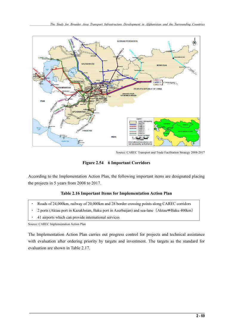
Figure 2.54 6 Important Corridors
According to the Implementation Action Plan, the following important items are designated placing
the projects in 5 years from 2008 to 2017.
Table 2.16 Important Items for Implementation Action Plan
・ Roads of 24,000km, railway of 20,000km and 28 border crossing points along CAREC corridors
・ 2 ports (Aktau port in Kazakhstan, Baku port in Azerbaijan) and sea-lane (Aktau⇔Baku 400km)
・ 41 airports which can provide international services
Source: CAREC Implementation Action Plan
The Implementation Action Plan carries out progress control for projects and technical assistance
with evaluation after ordering priority by targets and investment. The targets as the standard for
evaluation are shown in Table 2.17.
The Study for Broader Area Transport Infrastructure Development in Afghanistan and the Surrounding Countries
2 - 69
Source: CAREC Transport and Trade Facilitation Strategy 2008-2017
Figure 2.54 6 Important Corridors
According to the Implementation Action Plan, the following important items are designated placing
the projects in 5 years from 2008 to 2017.
Table 2.16 Important Items for Implementation Action Plan
・ Roads of 24,000km, railway of 20,000km and 28 border crossing points along CAREC corridors
・ 2 ports (Aktau port in Kazakhstan, Baku port in Azerbaijan) and sea-lane (Aktau⇔Baku 400km)
・ 41 airports which can provide international services
Source: CAREC Implementation Action Plan
The Implementation Action Plan carries out progress control for projects and technical assistance
with evaluation after ordering priority by targets and investment. The targets as the standard for
evaluation are shown in Table 2.17.

The study for Broader Area Transport Infrastructure Development in Afghanistan and the Surrounding Countries
2 - 70
Table 2.17 Targets of Implementation Action Plan
・ Improvement of CAREC corridors as 75% in 2012 and 100% in 2017 comparing with 64% of year 2007
・ Increase the volume of trade with EU and east Asia from 1% (34million ton) in 2005 to 2% in 2012 and 5% in 2017
・ Increase the volume of trade within the area from 32million ton (2005) to 25% more in 2012 and 50% more in 2017
・ Decrease the necessary time for border crossing along the CAREC corridors 12% less (2012) and 30% less (2017)
than year 2007
・ Activate the function of committee for trade infrastructure development to manage the inland transportation and
CAREC corridors by year 2012
Source: CAREC Implementation Action Plan
A total of 62 investment projects (US$21.1billion) were nominated in the implementation plan; 40
projects (US$15.8billion) are new projects and 22 projects are continuous projects. Technical
assistance (TA) is US$68.5million.
Table 2.18 Scale of Investment and TA Projects
Investment TA
New Continuous Total New Continuous Total
Road 10.3 2.5 12.8 10.3 1.8 12.1
Railway 4.3 1.4 5.7 6.8 0.0 6.8
Airport, Aviation 0.5 0.4 0.9 11.6 0.5 12.1
Port, Shipping 0.1 0.4 0.5 2.0 0.0 2.0
Physical Distribution 0.4 0.1 0.5 7.2 1.1 8.3
Develop Trade 0.2 0.5 0.7 25.5 1.7 27.2
Project
Amount
Total 15.8 5.3 21.1 63.4 5.1 68.5
Road 12 13 25 12 2 14
Railway 15 3 18 10 0 10
Airport, Aviation 6 1 7 4 1 5
Port, Shipping 1 1 2 2 0 2
Physical Distribution 4 1 5 8 2 10
Develop Trade 2 3 5 23 1 24
Nos.
of
Projects
Total 40 22 62 59 6 65
Source: CAREC Implementation Action Plan
(2) Assistance Projects by ADB
ADB actively implements the assistance projects for Afghanistan and the surrounding countries
regarding development of broader corridors in and out of CAREC. Table 2.19 shows the assistance
projects for development of broader corridors around Afghanistan.

The Study for Broader Area Transport Infrastructure Development in Afghanistan and the Surrounding Countries
2 - 71
Table 2.19 Assistance Projects for Development of Broader Corridors around Afghanistan (1)
Activities Objective/Purpose/Output Status
1. TA4536 Cross Border Trade and Transport Facilitation (Afghanistan) (Cross-border infrastructure)
Objective:
Growth and poverty reduction
Purpose:
Smooth movement of goods across borders by developing border facilities and promoting border cooperation
Output:
・A long-term perspective plan for infrastructure investment options to
improve transit of goods,
・Amended/new customs and border procedures (laws, rules and
regulations),
・Amended/new bilateral, trilateral and multilateral agreements,
・Individual arrangements rationalized and strengthened by ministries and
agencies for facilitating movement of goods, vehicles and people (including possible introduction of TIR Carnet arrangement or a simpler system allowing vehicles to cross border automatically),
・A framework for private sector participation in cross border trade transit,
・Integrated development alternatives for each corridor including railways
network into Afghanistan,
・Cost (O&M and debt services) recovery measures (toll, fuel tax, transport
fee), and
・Economic and financial feasibility/impact of investments in cross-border
facilities
Inception Report was prepared and submitted to the Government of Afghanistan in August 2005. Interim Report was prepared in December 2005 and submitted to the Government of Afghanistan in January 2006. Final Report was prepared in May 2006 and presented to the Government in June 2006.
2. Corridor Development Plan (CDP)-CSATTF (Infrastructure and policies and institutions)
Objective:
Promote economic growth through trade expansion
Purpose:
Remove physical, institutional and political impediments to the growth of trade
Output:
・Infrastructure investments
・Strengthening trade-related institutions
・Harmonizing transport, trade, tariff, policies, standards and regulatory
frameworks in conformity with international regulations
Elements are being worked on through initiatives by CSATTF and participating countries for infrastructure development, customs cooperation and transit system arrangement.
3.TA CDP Customs
- CSATTF(Customs)
Objective:
Promote economic growth through trade expansion
Purpose:
Facilitate movement of goods across the border
Output:
・Development of corridor transit systems – customs transit guarantee and
simplified transit systems such as ECO Single Transit Pass
・Simplification and harmonization of customs procedures and
documentation
・Development of border posts and facilities
・Data and information sharing and information and communication
technology (ICT) development for customs operation
・Application of modern customs automation techniques
In this context, CAREC is looking into;
・Capacity building
・Development of risk management and post-entry audit
・Development of regional intelligence system
Under the umbrella of the CSATTF work on various components is underway on corridor transit systems and customs harmonization. WB, EC and US have been supporting development of border posts and facilities (see below) as well as ICT and automation (e.g. ASYCUDA in Afghanistan)
4.Transit study –
CSATTF (Transit)
Objective:
Facilitate cross-border trade
Purpose:
(i) Assist TISA to revise/update the existing transit trade agreements and to develop new agreements with the neighbouring countries as appropriate; (ii) To prepare a report on regional transit trade facilitation measures
Output:
・Proposals to overcome constraints to cross-border trade
・Propose simplified transit system compatible with ECO’s Ttransit Trade
Agreement and Transit Transport Framework Agreement
・National action plans for efficient regional transit arrangement
・Revised and new transit agreements between Afghanistan and
neighbouring countries
Not initiated yet. It will be synchronized with TA4356 Cross Border Trade and Transport Facilitation.
Source: Afghanistan; Cross Border Trade and Transport Facilitation, ADB

The study for Broader Area Transport Infrastructure Development in Afghanistan and the Surrounding Countries
2 - 72
Table 2.19 Assistance Projects for Development of Broader Corridors around Afghanistan (2)
Activities Objective/Purpose/Output Status
5.TA4221
Cross Border Facilities and Efficient Transit Facilitation (Pakistan) (Transit)
Objective:
Promote cross-border trade Purpose: Facilitate movement of goods, trucks and related personnel
Output:
・Legal and institutional framework for cross border and transit movement
(1965 Agreement)
・Recent Pakistan facilitation
experiences and comparison with “best practice”
・Short and long-term concepts for Chaman border crossing station
・Short-term operational plan
・Long-term physical and organizational plan
・Environmental and social resettlement issues
Consultants hired. Inception and Inception reports have been prepared and submitted to the Government. Draft Final report is currently under review.
6.Cross border
infrastructure development, a component of the Pakistan Subregional Connectivity and Trade Facilitation Project (Pakistan) (Transit infrastructure)
Objective:
Support regional cooperation by improving physical, institutional and other barriers Purpose: Improve road sector efficiency
Output:
・Cross border agreements for road transport including movement of
containers
・Cross border civil works
・Feasibility study for establishing a Trade Facilitation and Land Border
Crossing Authority
Project under processing for expected approval in September 2005
7.Regional business
roundtable (Public-private partnership)
Objective:
Promote private sector participation in cross border trade, transport andother facilities
Conducted in Bishkek in October 2005.
8.National Action
Plan (NAP) (Participating countries with ADB assistance) (Action Plan)
Objective:
Promote regional trade
Purpose:
Facilitate cross border movement of goods
Output:
・Infrastructure development plan
・Trade and transport facilitation measures
・Establishment of National Trade and Transport Facilitation Committee
(NTTFC) with ADB/UNCTAD
・Accession to international trade and transport convention
Under way. Countries are taking steps to establish National Transport and Trade Facilitation Committee (NTTFC) and also for accession to international conventions, if they have not already done so.
9.ADB with Japan
(JFPR) Emergency Infrastructure Rehabilitation and Reconstruction Project (Afghanistan) (Infrastructure)
Objective:
Revive economic activities across the country
Purpose:
Rehabilitate and reconstruct key infrastructure in transport and energy sectors
Output:
・Road infrastructure
・Gas infrastructure
・Electric power infrastructure
Rehabilitation under way.
10.
Andhkhoy-Qaisar Road Project (Afrghanistan) (Infrastructure)
Objective:
Promote economic growth through improved roads and links to neighbouring countries
Purpose:
Reconstruct part of the ring road to improve access to Turkmenistan
Output:
・200km of the road constructed
・Provision for road tolling facility
Project approved in December 2004.
11.Balochistan
Road Development Sector Development Project (Pakistan) (Infrastructure)
Objective:
Promote economic growth of an underdeveloped region in Pakistan
Purpose:
Improvement of national highway, provincial access roads and cross border movement of goods
Output:
・1100km of provincial access roads upgraded
・247km of national highway upgraded easing access to Afghanistan
through Chaman
Under implementation
Source: Afghanistan; Cross Border Trade and Transport Facilitation, ADB

The Study for Broader Area Transport Infrastructure Development in Afghanistan and the Surrounding Countries
2 - 73
Table 2.19 Assistance Projects for Development of Broader Corridors around Afghanistan (3)
Activities Objective/Purpose/Output Status
13.Northwest
Frontier Province Road Development Sector and Subregional Connectivity (Pakistan) (Infrastructure)
Objective:
Promote economic activities and cross border trade
Purpose:
Improve road infrastructure and access to border with Afghanistan
Output:
・Construction of 334km of improved national highway easing access to
Afghanistan through Torkham and Ghulam Khan
・Border crossing infrastructure at Torkham and Ghulam Khan
・Capacity building
・Improved road safety
・Improved asset management
Under implementation
14.Qaisar - Bala
Murghab Road Project (Afghanistan) (Infrastructure)
Objective:
Promote economic growth through improved roads and links to neighboring countries
Purpose:
Reconstruct part of the ring road to improve access to Turkmenistan
Output:
・90km of ring road constructed
Project approved in September 2005
15.TA4371 Master
Plan for Road Network Improvement Project (Afrghanistan) (Infrastructure)
Objective:
Assist TISA to define a road network development strategy and program for 2006-2015 periods and estimate the financing requirements for investment and sustainable operation and maintenance.
Purpose:
Define the most efficient road network within a multi-modal transport network, giving due consideration to a railway option on some routes
Output:
・Road sector master plan
・Road network and traffic database
・Computerized road network model
Draft Final Report in September 2005
16.TA Capacity
Building for Road Sector Institutions (Afghanistan) (Infrastructure)
Objective and purpose:
Strengthen Ministry of Public Works, undertake road sector reform and coordinate funding agencies
Under processing
17.TA
SubregionalEconomic Cooperation in South and Central Asia (CSATTF) (Infrastructure)
Objective and Purpose:
Assist implementation of Corridor Development Plan-Customs and develop other components of CDP Output:
・Public-private partnership
・National coordination
・Dialogue among stakeholders
・Studies and papers
・National Trade and Transport Facilitation Committee (NTTFC)
Under processing
18.Regional Trade
Facilitation and Customs Cooperation Program + three regional Tas (Kyrgyzstan and Tajikistan) (Trade/Customs)
Objective and purpose:
Integrate transition economies into world trading system
Output:
・Regional framework with cooperation mechanism
・Reformed and modernized customs organizations
・Strengthened legal and regulatory framework in conformity with
international standards
Under implementation
19.Regional
Customs Modernization and Infrastructure Development Project (Kyrgyzstan and Tajikistan) + TA to Tajikistan on Infrastructure and Customs (Infrastructure and Customs)
Objective and purpose:
Transition economies into world trading system
Output:
・Regional framework with cooperation mechanism
・Reformed and modernized customs organization
・Strengthened legal and regulatory framework in conformity with
international standards
・ICT system
・Border infrastructure
・Reduced smuggling due to anti-smuggling equipment and support
Under processing
Source: Afghanistan; Cross Border Trade and Transport Facilitation, ADB

The study for Broader Area Transport Infrastructure Development in Afghanistan and the Surrounding Countries
2 - 74
Table 2.19 Assistance Projects for Development of Broader Corridors around Afghanistan (4)
Activities Objective/Purpose/Output Status
20.Regional
Railways Development Project (Uzbekistan) (Transport)
Objective and purpose:
Improve sector efficiency and reform to attain market-based operations
Under processing
21.TA
Harmonization of Cross Border Initiatives for transport sector in Central Asia (AZE/KAZ/KGZ/TAJ/UZB/TKM/PRC) (Infrastructure)
Objective:
Promote goods movement and trade
Purpose:
Evaluate facilities at each border operation
Output:
・Common minimum standard for border facilities
・Identification of necessary changes in legislation and cross border
procedures
・Investment required for minimum standard
TBD
22.Road
Rehabilitation Project (Tajikistan) (Infrastructure)
Objective:
Promote economic growth by improving flow of goods and people
Purpose:
Rehabilitate part of national highway
Output:
・Rehabilitate 50% of the 190km section of Dushanbe to Nizhni Pyanzh
・Upgrade border facility
Rehabilitation almost complete
23.ADB with JBIC
Rehabilitation of Surab-Pnjgur Road (Pakistan) (Infrastructure)
Objective:
Promote economic growth by improving flow of goods and people
Purpose:
Rehabilitate part of national highway
Output:
・Rehabilitation of the Surab-Pnjgur Road facilitating approach to the
Gwador port
Under implementation
Source: Afghanistan: Cross Border Trade and Transport Facilitation, ADB
2.1.8.2 World Bank
Table 2.20 shows activities, objectives, purpose, output and status of assistance projects for
development of broader corridors around Afghanistan by the World Bank.
Table 2.20 Assistance for Development of Corridors around Afghanistan by the World Bank (1)
Activities Objective/Purpose/Output Status
World Bank Emergency Customs Modernization and Trade Facilitation Project (Afghanistan) (Infrastructure and customs)
Objective:
Facilitate cross border trade and transport and data entry and exchangeautomation
Purpose:
Increasing customs revenue collection, improving clearance time, and establishing customs tariffs, exchange rates, and valuation in line with internationally accepted practices
Output:
Components implemented directly by UNOPS
・Rehabilitate and modernize Revenue and Customs Headquarters Offices
for Ministry of Finance (MOF) with provision for key services
・Rehabilitate and modernize specific areas of Ministry of Commerce
(MOC) with provision of key services
・Refurbish office space within current Kabul ICD to provide infrastructure
for training and management of the Afghan Customs Department (ACD) ASYCUDA Project
・Design and construct modern headquarters offices for Customs and
Revenue Department of the MOF at location of the current Kabul Inland Clearance Depot (ICD)
・Design and construct a new Kabul ICD in Policharki location
・Design, build and rehabilitate existing infrastructure for control of
multi-modal transport of goods at Hairatan border crossing as well the establishment of an ICD
Under implementation. According to Mid-Term review, March 2006, the status of implementation is as follows: (i) Customs reform implemented including a modern customs code but very slow progress on draft and issue of sub-legislation to implement the custom laws; (ii) With some delay infrastructure work has now commenced and progress has been reported, e.g., (a) the new Customs facility at Hairatan is ready for hand over to the Government, (b) the refurbishment of existing Customs and Revenue Headquarter areas in the Ministry of Finance is complete, (c) Phase 2 of building renovation works at MOC is complete,;

The Study for Broader Area Transport Infrastructure Development in Afghanistan and the Surrounding Countries
2 - 75
Table 2.20 Assistance for Development of Corridors around Afghanistan by World Bank (2)
Activities Objective/Purpose/Output Status
・Construction and Rehabilitation at Islam Qala (left out due to border
delineation dispute with Iran and US army investment)
・Rehabilitate appropriate infrastructure to house radio communication
equipment as part of the development of an ACD specific communication network linking regional and headquarter offices at airport, Kabul ICD, Customs and Revenue HQ at MOF, Jalalabad Customs House, Mazare Sharif Customs House, Torkham Border Post, HeratCustoms House, Islam Qala Border Post, Kandahar, Nimroz, Heart and Torghandy and Hairatan Border Posts
・Design and build modern Customs House and ICD in Current Jalalabad
location
・Support European Commission (EC) construction of a Customs House at
Torkham through provision of power generators
・Design and build a new mini ICD at Torghandy to control transport of
goods at border by both rail and truck
・ICT Communications Network and IT:
(i) Design, install and train staff on radio telecommunication systems (VHF and HF) supplied by the project, (ii) Procure IT equipment and support staff in maintenance at ministries and customs houses
・Support the establishment of Customs Reform Unit (CURE) at
MOF/ACD UNCTAD component
・Installation of Automated Systems for Customs Data (ASYCUDA) in a
phased approach ultimately establishing a national network for the processing and sharing of transit and goods declaration information: (i) Staff of ACD national HR structure will be trained to implement ASYCUDA in successive pilot programs, (ii) ASYCUDA technical and structural requirements and all procurements will be incorporated into infrastructure development of transit and declaration modules
・Trade facilitation: Restructuring of the International Transit Department,
working on regional and bilateral trade agreements with Pakistan and others and TIR, strengthening role of the private sector with a specific focus on freight forwarders, WHO accession, study on the railways especially regarding Hairatan railway terminal and the potential of transit with other neighboring countries
・Customs transit issues:
Provide regional perspective, advice and recommendations on customstransit operations
UNIDO component
・National Commission for Standards, Metrology and Quality:
(i) Modification of Afghan Standards Act: Draft law is being reviewed by the Ministry of Justice and the Standards Law should be finalized by the end of July, (ii) Create an independent Afghan Standards Authority within MOC, (iii) Standards and metrology infrastructure (laboratories) will be built and equipment procured within relevant infrastructure projects and a central laboratory will be constructed in Kabul. Plans include quality study of fuels entering Afrghanistan by service providers, two mobile laboratories for metrology and fuels, test labs at ICDs for use by customs and standards, and two central laboratories at Kabul and Polytechnic Universities.
(iii) Progress made with implementation of ASYCUDA with the pilot of the transit module on the Torkham-Jalalabad-Kabul corridor under way; (iv) VHF and HF radio equipment deployed at 10 locations; (v) Customs Reform Coordination Unit (CURE) working since mid-2005; (vi) Customs Advisory
Unitand Training Coordination Unit established; (vii) ACD prepared a strategy for developing customs enforcement; (viii) AFPRO established by a Presidential Decree of January 18, 2006 to act as Secretariat of NTTFC;
(ix) Afghan Freight Forwarding Industry strengthened; (x) Analytical work done on ATTA;
(xi) Afghan National Standards Authority
(ANSA) established; and (xii) The Standards Law
drafted.
Source: Afghanistan; Cross Border Trade and Transport Facilitation, ADB

The study for Broader Area Transport Infrastructure Development in Afghanistan and the Surrounding Countries
2 - 76
2.1.8.3 Assistance to the Broader Area Network for Afghanistan and the Surrounding
Countries by ECO
(1) Constituent Countries of ECO and the Action Programs
ECO succeeded the programs of the Regional Cooperation for Development (RCD) which activities
were carried out from 1964 to 1979. In 1985, the ECO was established for the purpose of social
economic development cooperation as a part of cooperation in East Asia by Iran, Turkey and
Pakistan. After that, the Charter of ECO Izmir was adopted, and their aim and frame work of
activities were agreed. After the frame work was ratified by the 3 countries, ECO was formally
inaugurated in 1991. The next year, in November 1992, Islamic CIS countries Tajikistan, Kyrgyz,
Kazakhstan, Uzbekistan, Turkmenistan, Azerbaijan, being formed after the collapse of the Soviet
Union, along with Afghanistan, formally joined ECO. The “Almaty Outline of Transport” was
adopted in October 1993; it is an agreement regarding development of regional transport network
which constitutes the core of ECO. In the special summit conference in May 1997, the “10 year plan
for Development of Network for Oil/Gas Pipeline and Communication/Transport” was adopted.
Establishment of enterprise with application of the ECO frame work is also active; the “ECO Trade
Development Bank”, “ECO Re-insurance Company”, “ECO Shipping Company”, “ECO Airline”
and so on, were established and approved in the 3rd summit conference in 1995. Regarding transit,
the “Memorandum about Smuggling and Dishonest Acts in Custom Duties” and “Transit Transport
Framework Agreement (TTFA)” were signed in 1998; the “ECO Trade Cooperation Framework”
and TTFA were discussed in the 6th summit conference in June 2000 and through the Baku
minister-level conference in May 1999 and Tehran minister-level conference in June 2000, those
were resolved and approved. There are many agreements regarding Afghanistan and surrounding
countries, in which ECO plays a central role, however, some of them are evaluated as inadequate
because of insufficient increase in export in the ECO region.
ECO members consist of 10 countries and their activities include various fields. ECO is not aiming
at integration of governance as EU, but aiming at political coordination regarding each national
development plan, priority and national interests.
ECO secretariat reports the results of foreign ministers conferences and top intention conferences to
the Summit conferences. Regarding the implementation of projects, the role of related organizations
is significant. Also, ECO cooperates with SAARC and so on, concluding with formal Minutes of
Understanding.

The Study for Broader Area Transport Infrastructure Development in Afghanistan and the Surrounding Countries
2 - 77
(2) Assistance to Afghanistan by ECO14
Afghanistan is an important original member country of ECO. ECO is highly interested in
rehabilitation of Afrghanistan and implementing projects for building hospitals, development of
Bamiyan and rural community training centers. Also, after Minutes of Understanding, ECO through
its project team and along with EU is commencing a project for measures to prevent illegal drug
trafficking to be completed within 2 years.
ECO is meeting with representatives regarding Japanese assistance for Afghanistan, and ECO
regards that it is meaningful to develop together with international or JICA potential. ECO considers
that the traffic infrastructure for Afghanistan should be widely assisted.
The high priority sectors for ECO are traffic, trade and energy. The importance of the traffic sector is
strongly expressed. A superior and eager team is implementing the project for trade and economy
which is the main target for ECO. Iran is a transit country; therefore, Iran has commenced a project
to secure access routes from the land-locked countries to the Arabian Sea because there are
important north-south corridors and east-west corridors in Iran. Iran intends to research obstacles,
benefit and realization probability through the project.
According to the ECO’s evaluation, the regional political power balance has changed during the
recent 10 years, the influence of Chaina and India is increasing in ECO region. The same condition
is found in the transport sector; issues should be brought to the attention of China and India in
addition to proper members such as Iran, Turkey and Pakistan. ECO considers that regional
cooperation regarding ports is an important issue; 4~5 forums and meetings are under way. As a
basic work for broader transit transport in the land-rocked countries, the needs assessment studies in
the related countries are important. Also, ECO presents that detailed assistance would be prepared
for transport needs in each transport corridor.
According to ECO, there are 2~3 types of approaches for trade acceleration policy, tax favourable
treatment, privatization assistance, assistance for hardware such as office buildings, and separate
measures for favourable treatment. ECO assists separate agreements for regional agreements for
each member country; there is a method to utilize the system as tripartite conferences by ECO, IDB
and UNSCAP or TTFA.
ECO proposed the implementation of workshops or training courses regarding the transport sector
under the assistance of JICA. The reason is; ECO already has a set-up workshop for capacity
building with the World Bank joined by IDB, and Japan is highly expected regarding new assistance.
There is merit in joint implementation by Iran and Afghanistan because of no political tension.
Also, ECO is considering a scheme to utilize a fund for Afghanistan Tajikistan and Kyrgyz. For
application of the scheme, implementation of a joint program with IDB, ADB, ECO Development
Bank after Minutes of Understanding. JICA is expected to cooperate in it.
14 The following description is based on the hearing by JICA mission team in the ECO secretariat in October 2009.

The study for Broader Area Transport Infrastructure Development in Afghanistan and the Surrounding Countries
2 - 78
2.1.8.4 Others
Assistance to the broader area network for Afghanistan and the surrounding countries by others is
shown in Table 2.21 below.
Table 2.21 Assistance for Development of Corridors around Afghanistan by Others (1)
Activities Objective/Purpose/Output Status
1.Government of
Iran(Iran) Road construction and improvement between Bandar Abbas and Dogharun (1,379km) (Infrastructure)
Objective and purpose:
Facilitate movement of goods across border
・Two-lane asphalt pavement
Completed
2.Government of Iran
(Iran) Road improvement between Milak and Zaranj, and construction of Zabol-Milak road and customs facilities at Milak border crossing (Infrastructure)
Objective and purpose:
Facilitate movement of goods across border
・Two-lane asphalt pavement
・New road between Zabol and Milak
・New customs facilities at Milak
Under implementation, part completed.
3.Government of Iran
(Iran) Road bypass to Chabahar-Iranshar link and upgrading of Chabahar-Zahidan road (Infrastructure)
Objective and purpose:
Facilitate movement of goods across border and approach to Chabahar port
・Two-lane asphalt pavement
Completed
4.Government of
Turkmenistan Road improvement from Atamurat to Imamnazar at the Afghanistan border
Objective and purpose:
Facilitate trade and cross border movement
Completed
5.Government of
Uzbekistan (Uzbekistan) Improvement of primary roads including Tashkent-Termez (Infrastructure)
Objective and purpose:
Facilitate trade and cross border movement
Output:
・Primary road improved to a two-lane or wider standard to facilitate
movement of goods
Completed
6.EC (European
Commission) Afghan Customs Reform under First Financing Agreement (Afghanistan) (Infrastructure and customs)
Objective:
Reinforce the revenue base of the government
Purpose:
Re-establish a functioning customs and revenue system
Output:
・Afghan Customs Code
・Rehabilitation of Torkham border post infrastructure
・Setting up EUROTRAC, computerized statistical package for customs
and tax management
Under implementation. The Customs building at Torkham has been officially handed over to the Custom in March 2006.
7.EC
Fourth Reconstruction Program for Afghanistan – Customs and Tax (Afghanistan)
Objective:
Reinforce the revenue base of the government
Purpose:
Reestablish a functioning customs and revenue system
Output:
・A national and international transit system for customs and revenue is
set up
・Customs staff has the required competencies to manage the system
・Customs and revenue headquarters on regional level are
reconstructed/newly built an appropriately equipped to ensure sound functioning
Under processing
8.USAID and Japan
Rehabilitation of Kabul-Kandahar Road (Afghanistan) (Infrastructure)
Objective and purpose:
Improve internal and cross border traffic flow Output:
442km from km43 to km485 rehabilitated with asphalt concrete pavement
Rehabilitation / reconstruction work completed
Source: Afghanistan; Cross Border Trade and Transport Facilitation, ADB

The Study for Broader Area Transport Infrastructure Development in Afghanistan and the Surrounding Countries
2 - 79
Table 2.21 Assistance for Development of Corridors around Afghanistan by Others (2)
Activities Objective/Purpose/Output Status
9.Government of Iran
Rehabilitation of Dogharun-Herat-Islam Qala Road-124km (Afghanistan) (Infrastructure)
Objective and purpose:
Facilitate cross border trade
Output:
・The road upgraded to 7.3m carriageway asphalt surface road
Upgrading completed
10.Government of Iran
Construction of Milak bridge (Iran/Afghanistan) (Infrastructure)
Objective and purpose:
Facilitate cross border trade
Output:
A 320m bridge across border completed with 5km section of Zaranj under construction
Construction completed
11.WB
Construction / rehabilitation of Sirkhan Bandar-Pule Khomri Road under Emergency Transport Rehabilitaiton Project (Afghanistan) (Infrastructure)
Objective:
Facilitate cross border movement of goods
Output:
・Construction / rehabilitation of the 172km road improving links to
Tajikistan
Construction / rehabilitation almost completed
12.WB
Construction / rehabilitation of Doshi-Kabul road and rehabilitation of the Salang Tunnel under Emergency Transport Rehabilitation (Afghanistan) (Infrastructure)
Objective:
Rehabilitate critical road infrastructure to facilitate movement of goodsand people
Purpose:
Clear the passage way to the north for internal and cross border movements
Output:
・Rehabilitation / reconstruction of 172km Doshi-Kabul road under way
・Rehabilitation of the Salang Tunnel completed
Construction / rehabilitation almost completed
13.Japan / ADB /
Kuwait Fund for Arab Economic Development Road Employment Project for Settlement and Integration of Returning Refugees and Displaced Persons (Afghanistan) (Infrastructure)
Objective:
Assist in Settlement and Integration of Returning Refugees and Displaced Persons
Purpose:
Rehabilitate transport infrastructure and provide social services to the refugees and the displaced
Output:
・Rehabilitate 105km of the Knadahar-Spin Boldak road
・Upgrade marketable skills of the beneficiaries
・Provide educational and health services
・Extend micro credit to the clients
Work completed on first 61.4km with resources available. Some construction problems on this section have been addressed. Government resources are being utilized to finance the remaining 42km.
14.Islamic
Development Bank
(IsDB)
Doshi-Pule Khomri road (Afghanistan)
Objective:
Facilitate movement of goods and people and promote economic activities
Purpose:
Rehabilitate essential infrastructure
Output:
・Rehabilitate 47km of Doshi-Pule Khomri road
Under implementation
15.US / Tajikistan /
Afghanistan New bridge across Pyanj river (Tajikistan / Afghanistan)
Objective:
Facilitate cross border movements
Purpose:
Improve road links
Output:
・Construction of a new bridge across Pyanj river
With US financing work has started
16.EC
Kabul-Jalalabad road (Afghanistan) (Infrastructure)
Objective:
Facilitate movement of goods and people
Purpose:
Improve links to the north and Pakistan
Output:
・Emergency repairs and reconstruction of the 150km road
Under implementation
17.Government of
Pakistan Jalalabad-Torkham road (Afghanistan) (Infrastructure)
Objective:
Facilitate cross border movements
Purpose:
Improve road links and Pakistan
Output:
・Reconstruction of 74km road
Under implementation
Source: Afghanistan: Cross Border Trade and Transport Facilitation, ADB

The study for Broader Area Transport Infrastructure Development in Afghanistan and the Surrounding Countries
2 - 80
Table 2.21 Assistance for Development of Corridors around Afghanistan by Others (3)
Activities Objective/Purpose/Output Status
18.Japan / Saudi
Arabia / US Kandahar-Heart road
Objective:
Facilitate movement of goods and people
Purpose:
Improve links to the neighboring countries
Output:
・Rehabilitation of the 564km section of the ring road with cement and
concrete pavement improving links to Iran and the Central Asian Republics (CAR)
Rehabilitation / reconstruction under way
19.Government of
Pakistan Indus Highway (N55) Hyderabad – Peshawar (Pakistan) (Infrastructure)
Objective and purpose:
Facilitate internal and cross border movement of goods and people
Output:
・1,265km of national highway upgraded to two lane 100km/h design to
improve movement
1,265km of national highway upgraded to two lane 100km/h
20.Government of
China Construction of Gwador Port (Pakistan) (Infrastructure)
Objective:
Promote an alternative exit point through Pakistan for domestic and foreign goods and promote the development to of an undeveloped region in Pakistan Purpose:
Facilitate cross border trade
Output:
・Construction of berths and other facilities
Under implementation
21.IMF / EC / USAID /
DFID / GTZ and other Strengthening Afghanistan Customs Department (ACD) (Afghanistan) (Capacity Building)
Objective:
Improve revenue collection
Output:
・Technical support
・Training
・Change management
・Communications
・Transit
Under implementation
22.UNDP
Upgrading ASYCUDA (Iran) (ICT)
Objective:
Facilitate trade and revenue collection
Output:
・Automation and customs data exchange
Under implementation
23.USAID
Revision of the Soviet Customs Code (Tajikistan) (Customs)
Objective:
Facilitate trade and improve revenue collection
Output:
・Modified customs code revised to make it compliant with international
standards
Completed
24.USAID
“Software” support for customs and cross border trade (Afghanistan) (Customs)
Objective:
Strengthen customs
Purpose:
Enhance revenue generation
Output:
・Prefabricated structures for 11 cross border control zones (BCZ)
・Advisors for customs and revenue departments of the MOF
・Support for accession to WTO, bilateral trade facilitation agreements,
and privatization of the national insurance company
Under implementation
25.Government of
India Delaram-Zaranj road
Under construction by Border Road Organization
Source: Afghanistan: Cross Border Trade and Transport Facilitation, ADB

The Study for Broader Area Transport Infrastructure Development in Afghanistan and the Surrounding Countries
2 - 81
2-2 Summary
2.2.1 Broader area issues
(1) Current Status of Subject Areas
The countries subject to this study are mainly agricultural countries and some of them have a very
high level of production of mineral resources, petroleum, natural gas and other forms of energy.
Some of them have great population and need for labor and consumption. Therefore, they have much
potential for economic development such as the need for trading of resources and processing them.
On the other hand, due to the instability of security in Afghanistan, trade is limited to restrictive
routes in the area and various growth potentials have not been fully realized. Under the
circumstances, sustainable economic activities and development are considered to be low in the
subject areas.
(2) Significance of Regional Economic Development by Broader Transport Infrastructure
i Economic and industrial properties of the subject area
Agriculture is the main industry in the area but CIS countries have mineral resources and there
are petroleum and natural gas in Iran, Turkmenistan, Kazakhstan and Uzbekistan.
ii The current status and potential for development
The intra-area trade is closed due to the security problems in Afghanistan, and the trade potential
is underdeveloped due to limitation of trade routes.
iii Possibility of regional development by corridors
Revitalization of logistics can be achieved by trade of products from Afghanistan and
development of corridors which will be the routes to export agricultural products to the
surrounding consumption areas, and export and processing of intra-area resources and materials.
iv Significance of developing Afghan transit routes
Benefits to Afghanistan through logistics routes are the promotion of sustainable development
by construction of routes that connect CIS countries and the Arabian Sea, and revitalization of
trade among Iran, India and Pakistan.
(3) Need to Develop Afghan Transit
By building an intra-area network, further opportunity is brought by connecting resources and
people of the countries in question, which creates and promotes new economic activities. The
development of intra-area networks in the countries in question and the Afghan Transit going
through Afghanistan will connect the resources, technology and markets in the surrounding countries
to realize intra-area revitalization of trade and trigger development of the industrial potential of each
country. The sustainable economic development of all countries in question will be realized by
diversification and stabilization of the inland countries which have limited resources and
environment and by contributing to expansion of hinterland in the case of coastal countries.
Therefore, the intra-area network of Afghan Transit connecting Afghanistan and the surrounding
countries will play a vital role to realize sustainable economic development of the area, and the
significance of the development is great.

The study for Broader Area Transport Infrastructure Development in Afghanistan and the Surrounding Countries
2 - 82
2.2.2. Inter-sectoral Issues
(1) Road Sector
In this section, the current status of the road networks crossing the countries in question is reviewed
from the viewpoints of road design standards, traffic volumes, logistics and logistic barriers on the
whole.
A. Road Design Standards and Traffic Volume
The degree of development of road infrastructure in the subject countries differs due to their
historical backgrounds and economic power in the recent years. The status of international arterial
roads in each country is described in Chapter 2-1. Figure 2.55 on the next page shows the road
design standards and traffic volume of each country.
Concerning the road network of Afghanistan and the surrounding country, we studied the logistics
connecting Afghanistan and the CIS countries in relation to the ports in Iran and Pakistan (Bandar
Abbas, Chabahar, Karachi and Gwadar ports).
a) Iranian Ports (Bandar Abbas/Chabahar)-to the CIS Countries
The Iranians, as mentioned above, have been developing roads by themselves owing to their rich
economic power and have networked major domestic cities by high-grade highways. The Iranian
road network plays the role of distribution routes to transport to CIS countries and Afghanistan, and
partially to Pakistan, the goods landed at Bandar Abbas and Chabahar ports. The routes to CIS
countries from the Iranian ports are as follows:
① The route through Mashhad to Turkmenistan, not through Afghanistan to Dushanbe,
Tashkent, etc.
② The route through Mashhad to Turkmenistan via Herat and Aquina and to Uzbekistan via
Mazar-e-Sharif
③ The route from Zahedan via Zaranj and Dilaram to Turkmenistan and Uzbekistan
Currently, mostly route ① is used.
The other routes are not selected because there is a section where the road rehabilitation project has
not been completed between Aquina and Herat, the north of the ring road in Afghanistan, and there
are sections of bad pavement and areas of bad security. The CIS countries including Uzbekistan
should expect to pay high transit fee if only the route via Turkmenistan is selected upon forwarding
goods to the Iranian ports and they strongly desire development of another route through
Afghanistan.

The Study for Broader Area Transport Infrastructure Development in Afghanistan and the Surrounding Countries
2 - 83
Figure 2.55 Design Standards and Traffic Volume of International Arterial Roads
The Study for Broader Area Transport Infrastructure Development in Afghanistan and the Surrounding Countries
2 - 83
Figure 2.55 Design Standards and Traffic Volume of International Arterial Roads

The study for Broader Area Transport Infrastructure Development in Afghanistan and the Surrounding Countries
2 - 84
Concerning the route ①, Figure 2.56 shows the road design standards and traffic volume along the
route connecting Bandar Abbas port, Mashhad and Turkmenistan
4,082 ~
14,535 22,401 8100 10973 21384 10244 8,100 5,057 1,651 7,989
Section Length(km) 300 203 95 88 27 197 330 82 153 420
AH Reference AH70 AH70 AH2 AH2 AH2 AH2 AH2 AH75 AH75 AH75
A.H.Design Standard Ⅰ・Ⅱ Ⅰ・Ⅱ Ⅱ Ⅰ Ⅰ Ⅰ・Ⅱ Ⅱ Ⅱ Ⅱ Ⅱ
Surface Condition Good Good Good Good Good Good Good Good Fair Fair
Terrain Flat・
Hilly・Flat・Hilly
Hilly・
Mountain
Hilly・
MountainFlat・Hilly
Flat・Hilly・
Mountainous
Country
7,844 ~
16,703 21,509 26,727 3,224 - - - 5,515 11,593 8,796
Section Length(km) 127 100 40 190 120 150 280 22 76 275
AH Reference AH75 AH75 AH1 AH75 AH75 AH5 AH5 AH5 AH5 AH5
A.H.Design Standard Ⅱ Ⅰ・Ⅱ Primary Ⅱ Ⅲ Ⅲ Ⅲ Ⅰ Ⅰ Ⅰ
Surface Condition Good Good Good Good・Fair - - - Good Good Good
Terrain (km) Flat・HillyHilly・
Mountain
Hilly・
Mountain
Flat・Hilly・
Mountainous- - - Flat Flat Flat
Country
12,635 ~ 5,259 ~
12,689 23901 7,891 7,219 9,467 2,475 2,785
Section Length(km) 202 75 27 110 150 289 169
AH Reference AH5 AH5 AH5 AH5 AH61 AH61 AH61
A.H.Design Standard Ⅰ Ⅰ Ⅰ Ⅰ・Ⅱ Ⅰ・Ⅱ・Ⅲ Ⅱ・Ⅲ Ⅱ・Ⅲ
Surface Condition Good Good Good Good・Fair Good・Fair Good・Fair Good・Fair
Terrain (km) Flat Flat Flat - ー ー ー
Country
Uzbekistan
KazakhstanUzbekistan
Gonabad
Tash
kent
Chern
yavka
(B
ord
er
of
Kaza
khst
an)
Sam
ark
and
TurkmenistanIran
Fara
p (B
ord
er
of
Uzbekis
tan)
Gonabad
Bukh
ara
Sam
ark
and
Sara
khs (B
ord
er
of
Turk
menis
tan)
Teje
n
Mary
AADT
AADT
AADT
Bandar
Abbas
Zahedan
Sym
kent
Kyzy
lord
a
Zhusaly
Syrd
aria
Anar
Iran
Jct. A
H1/A
H75
Mash
had
Rafs
anja
n
Bagheyn
Kerm
an
Bam
ザーヘダーン
カラチ
ラホール
イスラマバード
チャーバハール(グワダール)
アルマティ
ビシュケク
ペシャワール
ドゥシャンベ
カブール
バンダルアッバース
タシケント
アシュガバート
テヘラン
クェッタ
カンダハール
ヘラート
マザリシャリフ
タフタン
マシュハド
シムケント
オシュ
ハイラタン
バイニュー
ブカラ
グザール
サマルカンド シルダリア
メリー
トルクメンバシ
ポレクムリ
シルクハーン
ローリデリー
ヤズド
キジロルダメルケ
タルディ-コルガン
ケルマン
シャブゼバール
イシククリ
トルガルトサリタシュ
カラミク
クルマパス
アフガニスタンと周辺国の国際幹線道路網図
アーケシュタムカシュガル
バンダルアッバース-マシュハド-
ブカラ-タシケント-キジロルダ
ルート
AADT
Road Design Standard
Legend
Primary
Class Ⅰ
Class Ⅱ
Class Ⅲ
-
-
-
Data nothing
20,000
3,000
10,000
20,000
-
3,001
10,001
1
Figure 2.56 Road Design Standards and Traffic Volume between Bandar Abbas Port and CIS Countries

The Study for Broader Area Transport Infrastructure Development in Afghanistan and the Surrounding Countries
2 - 85
The route starts from Bandar Abbas Port to Zahedan in Iran, and further to CIS countries and Russia
without passing through Afghanistan. In Iran, the roads are basically well-developed and maintained.
The AH2 from Tehran to Kerman and Bam is a good route with many 4-lane sections. The roads in
Turkmenistan are Class III but according to UNESCAP, the major domestic road sections are being
renovated. The details are mostly unknown. The roads in Uzbekistan on the route are in a good
condition.
b) Pakistani Ports-CIS Countries
Main routes connecting Pakistani ports (Karachi/Qasim, Gwadar) and CIS Countries are:
i Karachi-Lahore-Peshawar-Kabul-Mazar-e-Sharif-Uzbekistan
ii Karachi-Quetta-Kandahar-Kabul-Mazar-e-Sharif-Uzbekistan
iii Gwadar- Quetta-Kandahar-Kabul-Mazar-e-Sharif-Uzbekistan
The major route is (i). Route (i) starts from Karachi to go north along the Indus River to N-5 (in
Pakistan) and is connected to Lahore, Peshawar and other points in Afghanistan. Routes (ii) and (iii)
have certain potential but Route (ii) has security problems in the Balochistan Area and NWFP Area
and Route (iii) has a problem that Gwadar Port is being extended and not many cargos are handled,
and the access road is yet to be developed due to security problems. Therefore, the transportation
depends on Route (i)
Concerning Route (i), the road design standards and traffic volume in connection with Karachi Port,
Lahore, Kabul and CIS countries are illustrated in Figure 2.57.
There is much traffic volume in Pakistan and the expressways between Karachi and Lahore and
between Lahore and Islamabad is an Asian Highway route and the situation as the international
arterial road is very good. According to the data of UNESCAP, there are some class III sections near
Rohri, for which development is awaited. Concerning the Pakistan/Afghanistan border, ADB intends
to rehabilitate the road between Peshawar and Torkham. The sections on the route in Afghanistan are
of 2 lanes. Progress has been made for improvement of the road by international donors and the ring
road and the route between Polekumri and Tajikistan border is good according to the evaluation by
UNESCAP. In Tajikistan, AH7 from the north to the south is Class II for all sections, but the traffic
volume is less than 6,000 vehicles (AADT) now, which means no problem in terms of traffic
capacity. In terms of comparison of the route, it seems that development is delayed to accommodate
the traffic volume in the section between the Tajikistan/Uzbekistan border and Syrdarya on AH7 in
Uzbekistan, as compared to the northern section between Syrdarya and Tashkent/Chernyavka
(Uzbekistan/Kazakhstan border).
The route is the current main route of logistics to reach Karachi Port in Pakistan from the CIS
countries. To secure smooth logistics route, it is felt that Class III sections on the route will have to
be developed.

The study for Broader Area Transport Infrastructure Development in Afghanistan and the Surrounding Countries
2 - 86
11,100 ~ 7,550 ~ 22,500 ~
14,712 12,275 9,000 36,757 4,774 7,100 6,585 6,030
Section Length(km) 388 138 782 46 323 160 56 77 147 64
AH Reference AH2 AH1 AH1 AH7
A.H.Design Standard Ⅰ Ⅲ Ⅰ Ⅰ Ⅲ Ⅱ Ⅰ・Ⅱ Ⅱ
Surface Condition Fair Bad Good・Fair Good Bad Good Fair Good
Terrain (km) Flat Flat Flat・Hilly Flat Flat Mountainous
Country
3,400 ~ 2,200 ~ 538 ~
3,900 2,500 41 1,080 5,799 4,532 13,443 21543 23,901 7,891
Section Length(km) 155 169 1 170 311 17 20 30 75 27
AH Reference AH7 AH7 AH7 AH7 AH7 AH7 AH7 AH7 AH5 AH5
A.H.Design Standard Ⅱ Ⅱ Ⅱ Ⅱ Ⅱ Ⅲ Ⅰ・Ⅱ Ⅰ・Ⅱ Ⅰ Ⅰ
Surface Condition Good Good Good Good Good Fair Good Good Good Good
Terrain (km)Rolling・
MountainFlat・Rolling Flat Flat Flat Flat Flat Flat Flat Flat
Country
5,310 ~ 7,894 ~ 3,521 ~
7,219 7,611 6,118 8,522 11,762 8,111
Section Length(km) 110 332 150 193 13 157
AH Reference AH5 AH5 AH61 AH5 AH5 AH60
A.H.Design Standard Ⅰ・Ⅱ Ⅰ・Ⅱ・Ⅲ Ⅱ・Ⅲ Ⅰ・Ⅱ・Ⅲ Ⅰ Ⅰ・Ⅲ
Surface Condition Good・Fair Good・Fair Good・Fair Good Good・Fair Good・Fair
Terrain (km) - - - - - -
Country
Chern
yavka (B
ord
er
of
Kazakh
sta
n)
Kazakhstan
Afghanistan
Djb
uls
arc
j
AADT
AADT
Tashke
nt
Chern
yavka (B
ord
er
of
Kazakh
sta
n)
Uzbekistan
Sym
kent
Merk
e
Kord
ai (B
ord
er
of
Kyrg
yzs
tan)
Kaskele
n
Alm
aty
Sary
ozek
Chanok (B
ord
er
of
Uzbekis
tan)
Syrd
aria
Tajikistan
Pole
kum
ri
Shirkh
an
Bord
er
of Tajik
ista
n
Dushanbe
Afghanistan
Praimary
Pakistan
Flat
Jala
labad
Lahore
Tork
ham
(Bord
er
of
Afg
anis
tan)AH1 AH1
Good
AADT
AH4Kara
chi
Rohri
13,581 ~
20,000
Flat
Kabul
Djb
uls
arc
j
Isla
mabad
カラチ
ラホール
イスラマバード
チャーバハール(グワダール)
アルマティ
ビシュケク
ペシャワール
ドゥシャンベ
カブール
バンダルアッバース
タシケント
アシュガバート
テヘラン
クェッタ
カンダハール
ヘラート
マザリシャリフ
タフタン
マシュハド
シムケント
オシュ
ハイラタン
バイニュー
ブカラ
グザール
サマルカンド シルダリア
メリー
トルクメンバシ
ポレクムリ
シルクハーン
ローリデリー
ヤズド
ザーヘダーン
キジロルダメルケ
タルディ-コルガン
ケルマン
シャブゼバール
イシククリ
トルガルトサリタシュ
カラミク
クルマパス
アフガニスタンと周辺国の国際幹線道路網図
アーケシュタムカシュガル
カラチ-ラホール-カブール-
ドゥシャンベ-シムケント-アルマティ
ルート
AADT
Road Design Standard
Legend
Primary
Class Ⅰ
Class Ⅱ
Class Ⅲ
-
-
-
Data nothing
20,000
3,000
10,000
20,000
-
3,001
10,001
1
Figure 2.57 Road Design Standards and Traffic Volume between Karachi Port and CIS Countries
c) The Route Circumventing the Afghan Borders
The route on the next page shows the route to shape a ring road among the countries neighboring
Afghanistan.
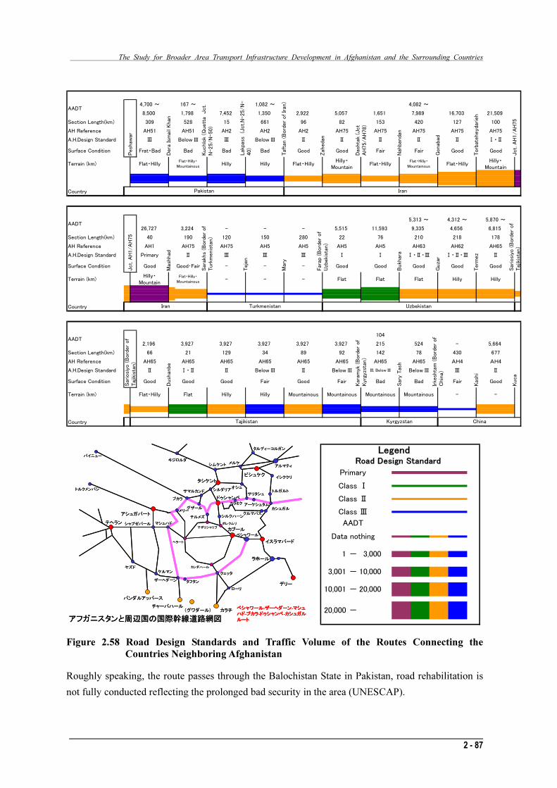
The Study for Broader Area Transport Infrastructure Development in Afghanistan and the Surrounding Countries
2 - 87
4,700 ~ 167 ~ 1,082 ~ 4,082 ~
8,500 1,798 7,452 1,350 2,922 5,057 1,651 7,989 16,703 21,509
Section Length(km) 309 528 15 661 96 82 153 420 127 100
AH Reference AH51 AH51 AH2 AH2 AH2 AH75 AH75 AH75 AH75 AH75
A.H.Design Standard Ⅲ Below III Ⅲ Below III Ⅱ Ⅱ Ⅱ Ⅱ Ⅱ Ⅰ・Ⅱ
Surface Condition Frat・Bad Bad Bad Bad Good Good Fair Fair Good Good
Terrain (km) Flat・HillyFlat・Hilly・
MountainousHilly Hilly Flat・Hilly
Hilly・
MountainFlat・Hilly
Flat・Hilly・
MountainousFlat・Hilly
Hilly・
Mountain
Country
5,313 ~ 4,312 ~ 5,870 ~
26,727 3,224 - - - 5,515 11,593 9,335 4,656 6,815
Section Length(km) 40 190 120 150 280 22 76 210 218 178
AH Reference AH1 AH75 AH75 AH5 AH5 AH5 AH5 AH63 AH62 AH65
A.H.Design Standard Primary Ⅱ Ⅲ Ⅲ Ⅲ Ⅰ Ⅰ Ⅰ・Ⅱ・Ⅲ Ⅰ・Ⅱ・Ⅲ Ⅱ
Surface Condition Good Good・Fair - - - Good Good Good Good Good
Terrain (km)Hilly・
Mountain
Flat・Hilly・
Mountainous- - - Flat Flat Flat Hilly Hilly
Country
104
2,196 3,927 3,927 3,927 3,927 3,927 215 524 - 5,664
Section Length(km) 66 21 129 34 89 92 142 78 430 677
AH Reference AH65 AH65 AH65 AH65 AH65 AH65 AH65 AH65 AH4 AH4
A.H.Design Standard Ⅱ Ⅰ・Ⅱ Ⅱ Below III Ⅱ Below III III, Below III Below III Ⅲ Ⅱ
Surface Condition Good Good Good Fair Good Fair Bad Bad Fair Good
Terrain (km) Flat・Hilly Flat Hilly Hilly Mountainous Mountainous Mountainous Mountainous - -
Country
Uzbekistan
Sary
Tash
Irkesh
tam
(B
ord
er
of
Chin
a)
Kash
i
Kuca
Kara
myk (B
ord
er
of
Kyrg
yzs
tan)
Tajikistan ChinaKyrgyzstan
AADT
AADT
AADT
Peshaw
ar
Kuchlo
k (Q
uett
a Jct.
N-25/N
-50)
Lakpass
(Jct.N
-25/N
-
40)
Taft
an (B
ord
er
of Ir
an)
Dera
Ism
ail
Khan
Zahedan
Jct. A
H1/A
H75
Jct. A
H1/A
H75
Mash
had
Pakistan Iran
Sara
khs
(Bord
er
of
Turk
menis
tan)
Teje
n
Mary
Fara
p (B
ord
er
of
Uzbekis
tan)
Sariosiy
o (B
ord
er
of
Tajik
ista
n)
Sariosi
yo (B
ord
er
of
Tajik
ista
n)
Iran Turkmenistan
Bukh
ara
Guza
r
Term
ez
Dush
anbe
Dashta
k (J
ct
AH
75/A
H78)
Nahbandan
Gonabad
Torb
ate
heydarieh
グザールカラミク アーケシュタム
ザーヘダーン
カラチ
ラホール
イスラマバード
チャーバハール(グワダール)
アルマティ
ビシュケク
ペシャワール
ドゥシャンベ
カブール
バンダルアッバース
タシケント
アシュガバート
テヘラン
クェッタ
カンダハール
ヘラート
マザリシャリフ
タフタン
マシュハド
シムケント
オシュ
テルメズ
バイニュー
ブカラ
サマルカンド シルダリア
メリー
トルクメンバシ
ポレクムリ
シルクハーン
ローリデリー
ヤズド
キジロルダメルケ
タルディ-コルガン
ケルマン
シャブゼバール
イシククリ
トルガルトサリタシュ
クルマパス
アフガニスタンと周辺国の国際幹線道路網図
カシュガル
ペシャワール-ザーヘダーン-マシュ
ハド-ブカラ-ドゥシャンベ-カシュガル
ルート
AADT
Road Design Standard
Legend
Primary
Class Ⅰ
Class Ⅱ
Class Ⅲ
-
-
-
Data nothing
20,000
3,000
10,000
20,000
-
3,001
10,001
1
Figure 2.58 Road Design Standards and Traffic Volume of the Routes Connecting the
Countries Neighboring Afghanistan
Roughly speaking, the route passes through the Balochistan State in Pakistan, road rehabilitation is
not fully conducted reflecting the prolonged bad security in the area (UNESCAP).
The Study for Broader Area Transport Infrastructure Development in Afghanistan and the Surrounding Countries
2 - 87
4,700 ~ 167 ~ 1,082 ~ 4,082 ~
8,500 1,798 7,452 1,350 2,922 5,057 1,651 7,989 16,703 21,509
Section Length(km) 309 528 15 661 96 82 153 420 127 100
AH Reference AH51 AH51 AH2 AH2 AH2 AH75 AH75 AH75 AH75 AH75
A.H.Design Standard Ⅲ Below III Ⅲ Below III Ⅱ Ⅱ Ⅱ Ⅱ Ⅱ Ⅰ・Ⅱ
Surface Condition Frat・Bad Bad Bad Bad Good Good Fair Fair Good Good
Terrain (km) Flat・HillyFlat・Hilly・
MountainousHilly Hilly Flat・Hilly
Hilly・
MountainFlat・Hilly
Flat・Hilly・
MountainousFlat・Hilly
Hilly・
Mountain
Country
5,313 ~ 4,312 ~ 5,870 ~
26,727 3,224 - - - 5,515 11,593 9,335 4,656 6,815
Section Length(km) 40 190 120 150 280 22 76 210 218 178
AH Reference AH1 AH75 AH75 AH5 AH5 AH5 AH5 AH63 AH62 AH65
A.H.Design Standard Primary Ⅱ Ⅲ Ⅲ Ⅲ Ⅰ Ⅰ Ⅰ・Ⅱ・Ⅲ Ⅰ・Ⅱ・Ⅲ Ⅱ
Surface Condition Good Good・Fair - - - Good Good Good Good Good
Terrain (km)Hilly・
Mountain
Flat・Hilly・
Mountainous- - - Flat Flat Flat Hilly Hilly
Country
104
2,196 3,927 3,927 3,927 3,927 3,927 215 524 - 5,664
Section Length(km) 66 21 129 34 89 92 142 78 430 677
AH Reference AH65 AH65 AH65 AH65 AH65 AH65 AH65 AH65 AH4 AH4
A.H.Design Standard Ⅱ Ⅰ・Ⅱ Ⅱ Below III Ⅱ Below III III, Below III Below III Ⅲ Ⅱ
Surface Condition Good Good Good Fair Good Fair Bad Bad Fair Good
Terrain (km) Flat・Hilly Flat Hilly Hilly Mountainous Mountainous Mountainous Mountainous - -
Country
Uzbekistan
Sary
Tash
Irkesh
tam
(B
ord
er
of
Chin
a)
Kash
i
Kuca
Kara
myk (B
ord
er
of
Kyrg
yzs
tan)
Tajikistan ChinaKyrgyzstan
AADT
AADT
AADT
Peshaw
ar
Kuchlo
k (Q
uett
a Jct.
N-25/N
-50)
Lakpass
(Jct.N
-25/N
-
40)
Taft
an (B
ord
er
of Ir
an)
Dera
Ism
ail
Khan
Zahedan
Jct. A
H1/A
H75
Jct. A
H1/A
H75
Mash
had
Pakistan IranSara
khs
(Bord
er
of
Turk
menis
tan)
Teje
n
Mary
Fara
p (B
ord
er
of
Uzbekis
tan)
Sariosiy
o (B
ord
er
of
Tajik
ista
n)
Sariosi
yo (B
ord
er
of
Tajik
ista
n)
Iran Turkmenistan
Bukh
ara
Guza
r
Term
ez
Dush
anbe
Dashta
k (J
ct
AH
75/A
H78)
Nahbandan
Gonabad
Torb
ate
heydarieh
グザールカラミク アーケシュタム
ザーヘダーン
カラチ
ラホール
イスラマバード
チャーバハール(グワダール)
アルマティ
ビシュケク
ペシャワール
ドゥシャンベ
カブール
バンダルアッバース
タシケント
アシュガバート
テヘラン
クェッタ
カンダハール
ヘラート
マザリシャリフ
タフタン
マシュハド
シムケント
オシュ
テルメズ
バイニュー
ブカラ
サマルカンド シルダリア
メリー
トルクメンバシ
ポレクムリ
シルクハーン
ローリデリー
ヤズド
キジロルダメルケ
タルディ-コルガン
ケルマン
シャブゼバール
イシククリ
トルガルトサリタシュ
クルマパス
アフガニスタンと周辺国の国際幹線道路網図
カシュガル
ペシャワール-ザーヘダーン-マシュ
ハド-ブカラ-ドゥシャンベ-カシュガル
ルート
グザールカラミク アーケシュタム
ザーヘダーン
カラチ
ラホール
イスラマバード
チャーバハール(グワダール)
アルマティ
ビシュケク
ペシャワール
ドゥシャンベ
カブール
バンダルアッバース
タシケント
アシュガバート
テヘラン
クェッタ
カンダハール
ヘラート
マザリシャリフ
タフタン
マシュハド
シムケント
オシュ
テルメズ
バイニュー
ブカラ
サマルカンド シルダリア
メリー
トルクメンバシ
ポレクムリ
シルクハーン
ローリデリー
ヤズド
キジロルダメルケ
タルディ-コルガン
ケルマン
シャブゼバール
イシククリ
トルガルトサリタシュ
クルマパス
アフガニスタンと周辺国の国際幹線道路網図
カシュガル
ペシャワール-ザーヘダーン-マシュ
ハド-ブカラ-ドゥシャンベ-カシュガル
ルート
AADT
Road Design Standard
Legend
Primary
Class Ⅰ
Class Ⅱ
Class Ⅲ
-
-
-
Data nothing
20,000
3,000
10,000
20,000
-
3,001
10,001
1
Figure 2.58 Road Design Standards and Traffic Volume of the Routes Connecting the
Countries Neighboring Afghanistan
Roughly speaking, the route passes through the Balochistan State in Pakistan, road rehabilitation is
not fully conducted reflecting the prolonged bad security in the area (UNESCAP).

The study for Broader Area Transport Infrastructure Development in Afghanistan and the Surrounding Countries
2 - 88
The route to cross from the east to the west in Tajikistan and to go from the east to west in the
southern part of Kyrgyz is topographically severe mainly in the sections crossing the Tian Shan
Mountains, and there are many Class III sections mainly in the mountainous sections. The section
from Dushanbe to the east crosses about 300km in the mountains, and it is possible that slope failure
may frequently occur. Road development will be needed in the future from the viewpoint of disaster
prevention.
B. Road Logistics Focusing on Afghanistan
Table 2.22 shows the trade items with neighboring countries in the statistics of Afghanistan. Major
import items are petrol oil, tires, diesel oil, flour, glass, carpets, iron rods, vehicle spare parts, clothes,
and gas. Export items are dry fruits, cumin (a kind of spice), carpets, sesame seed, grapes, etc. These
items are distributed mainly over roads.
According to IMF, in the total trade of US$5.4 billion of Afghanistan, US$1.2/1.7 billion is
estimated to be re-exports. It is often pointed out that a considerable amount of goods imported in
Afghanistan is reverse-exported to Pakistan and Iran.
Table 2.22 Afghan Trade Items Transported by Trucks to and from Neighboring Countries
TOTAL(100%) Import(84%) Export(6%) Transit(10%)
Iron metal Petrol oil Dry Fruit Iron metalPetrol oil Tire Cumin Vehicle spare partsCarpet Diesel oil Carpet Cotton
Tire Flour Sesame seed Iron rodsDiesel oil Glass Grapes CementFlour Carpet Animal Intestine Wheat
Glass Iron rods MelonIron rods Vehicle spare parts Fumiture
Vehicle spare parts Cloth RaisinCars Gas Apple
44% of Total 43% of Imports 99% of Exports 100% of Transit
Source: ADB TA 4536 survey 2005
The transit trade involving Afghanistan goes through the following two main routes:
i The route to transit Afghanistan to the third countries
ii The route to transit Turkmenistan to Afghanistan
The transit trade (i) via Afghanistan is to transport to Pakistan the goods from the northern
neighboring countries (Uzbekistan, Tajikistan, and Turkmenistan). Some of the goods, though not
many, are further transported to Iran and northern countries. Currently, Afghanistan is not
functioning as a center of logistics and the amount of transit trade is low. If the logistics
environments in the related countries are improved, the transit trade in the area will increase.

The Study for Broader Area Transport Infrastructure Development in Afghanistan and the Surrounding Countries
2 - 89
What follows next is the summary of trades between Afghanistan and the neighboring countries with
reference to the results summarized by the “Master Plan for Road Network Improvement Project in
Afghanistan, ADB 2006”.
a) Traffic Flow at Borders
According to the material issued by the Central Statistics Bureau, the total imports to Afghanistan in
2004 were about US$2.2 billion but the total exports were only US$305 million. In dollar values,
imports include machinery and equipment (28%), life necessities and medicines (14%), textiles,
clothes and shoes (18%), foods (6%), chemicals (4%), and others (22%). Thirty eight percent of
imports are from Asia and 63% of the imports are from other areas. The exports from Afghanistan
are mainly composed of agricultural products: dry fruits and nuts (27%), fruits (4%), medicinal
plants (3%), seeds and spices (1%), wool textile (3%), and leather (7%).
The major trade partner of Afghanistan is Pakistan. As of 2006 the annual trade value between
Afghanistan and Pakistan stood at US$1 billion but, in contrast, the trade with Iran stood at US$250
million.
The imports from Pakistan are mainly foods and construction materials. According to the formal
statistics of Pakistan, major items of export were various foods (53%), wheat (flour), sugar and rice
(27%), steel products (6%), cement (4.6%), and paint (3.8%).
The trade situations changed dramatically between the 1970s and after. In the period of Soviet
occupation, 70% of the total trade was with the Soviet Union. Goods were brought in by railways
from Termez near Uzbekistan and Torghundi near Turkmenistan. At that time, the trade volume with
Pakistan was about 20% and with Iran, about 10%. The country is now in a completely different
situation. The trade of Afghanistan is mainly with Pakistan and Iran, and the trade volume with the
north (Uzbekistan, Tajikistan and Turkmenistan) is little. Much of the rehabilitation assistance and
aid supplies comes mainly from Pakistan and commerce items come from Iran. Major import items
from central Asia are fuels. According to the Petroleum Company of Afghanistan, the country
imported liquid fuels reaching about 85,000m3, 79% of which came from Uzbekistan via Hairatan
and 19% of which was from Turkmenistan via Andkhoi. Two percent of fuel came from Iran via
Islam Qala.
The currently important border points in Afghanistan are:
・ The route to reach Karachi and Qasim ports via Torkham; and
・ The route to reach Bandar Abbas Port in Iran via Dogharun and Islam Qala.

The study for Broader Area Transport Infrastructure Development in Afghanistan and the Surrounding Countries
2 - 90
b) Current Status of Trade in the Area
The trade volume (logistics) is very small now. In the area including Central Asia and Afghanistan,
the trade ratio is 20% for Tajikistan which has the smallest economy, followed by Turkmenistan
which has the next smallest economy. The trade ratio of Afghanistan in the area is about 10%, which
is the smallest. Iran and Pakistan have trades with other parts of the world, differently from
Afghanistan, Tajikistan, Uzbekistan and Turkmenistan. For both countries, about 2% of the total
trades are imports and exports to and from the neighboring areas.
The small trade in the area has many reasons: the countries have similar economic structures; small
bases for exports; old, traditional routes; the vector of movement and logistics has headed to the
north (the Former Soviet Union), and the roads and railway networks have been developed in this
direction. Because of these reasons, the trades in the area are not growing much now.
Figure 2.59 Transit Trade that Passes through Afghanistan
C. The Logistics Barriers in Roads Connecting Afghanistan with the Neighbors
For expansion of cross-border trades in Central Asia and South Asia, the ”Report for Cross Border
and Transport Facilitation” lists the following points as current issues.

The Study for Broader Area Transport Infrastructure Development in Afghanistan and the Surrounding Countries
2 - 91
・Lack of supplementation and competition among the countries in the area
・Customs procedures
・Guideline for tradess
・PTA : Preferential Trading Arrangements
・Transhipment at border points
・Approval of transit trades
・Lack of vehicle standards and axle load restrictions
・Visa regulations
・Informal impositions
・Protection of local transportation
As a result of questionnaires to truck drivers, they listed 20 items that work as restrictions for
vehicles and cargo transportation. The five items below were most often reported by the drivers.
・Required procedure and time at formal check points were excessive.
・Lack of service facilities along the border access roads
・Lack of service roads to repair troubled vehicles
・Long processing time at borders/ICD (inland depots)
・Poor road quality
Figure 2.60 shows the barriers that hinder realization of smooth logistics as heard from
transportation providers (according to Cross Border and Transport Facilitation Report).
% of sample reporting
0 10 20 30 40 50 60 70 80 90 100
Documentation requirement
Pilferage of cargo
Dust
ICD working hours
Checking of cargo
Limited border hours
Informal commission
Visa
Noncooperation by officials
Poor facilities
Lack of parking at ICD
Informal check points
Lack of security
Illegal payments
Lack of proper system
Poor road quality
Long processing
Lack of service roads
Lack of service support
Formal check points
%
Source: Report on “Cross Border and Transport Facilitation, ADB 2006, with some additions
Figure 2.60 Issues in Vehicle Operation

The study for Broader Area Transport Infrastructure Development in Afghanistan and the Surrounding Countries
2 - 92
Concerning the items indicated in Figure 2-58, we classified the superior items for which multiple
answers were received for non-structural issues (red circle) and structural issues (blue circle), and
many of the answers were non-structural issues. Many of them were related to various procedures
and time relating to customs and crossing at borders and seaports, and lack of service functions near
such facilities. In addition to institutional underdevelopment of customs procedure and collection of
informal dues, not only the customs system is insufficient but also its operators are problematic.
Concerning structural aspects, underdeveloped access roads to the border points, underdeveloped
service facilities near the border points, shortage of parking spaces, and other insufficiencies of
border facilities and lack of service rather than passage in a country are pointed out.
(2) Railway Sector
A. Railway Network in the Surrounding Countries
To the north of Afghanistan, there are three CIS countries, i.e. Turkmenistan, Uzbekistan and
Tajikistan. The CIS countries established passenger and cargo transportation system mainly by
railways in the era of the Former Soviet Union. Due to financial difficulties after collapse of the
Former Soviet Union in December 1991, the rails and vehicles were under-maintained and the
system was about to break down. Due to assistance by international organizations such as JICA,
ADB and EU and economic independence supported by rich resources, the system has now been
reconstructed nearly to the level of 1991 or earlier.
The railway networks of these CIS countries are connected not only to other CIS countries but also
to the Russian Federation, Caucasia, and Mongolia on the same track gauge (1,520mm). The
maintenance situations vary among the countries but are roughly good with some exceptions. The
network is connected to China and Europe with a gauge of 1,453mm, but transshipment facilities,
bogie exchange and/or change of vehicles are necessary.
The railway goes into Afghanistan by 10km and 15km respectively from Turkmenistan and
Uzbekistan crossing the borders, and just in front of the border from Tajikistan and connection to
Afghanistan is planned as a future vision. By the grant aid of ADB, construction of about 60km has
begun from Uzbekistan Railways to Mazar-e-Sharif.
Iran, located west of Afghanistan, is active about railway development, and maintains as appropriate
the railway facilities, and new passenger vehicles of European specifications are being introduced.
With the standard gauge of 1,435mm, the rail is connected to Turkey and Europe. From the port of
Bandar Abbas, the rails go north to be connected to Turkmenistan. Although exchange of bogies and
transshipment of containers are required at borders, it plays a vital role as a line connected to Central
Asia. The access to Afghanistan is realized by the railway heading north from Bandar Abbas Port
branching to cross the border to the 60km point before Herat, but the construction is suspended due
to lack of funds.

The Study for Broader Area Transport Infrastructure Development in Afghanistan and the Surrounding Countries
2 - 93
Legend: ― Railway ― Border Capital Kabul
Figure 2.61 Current Railway Transport Network Surrounding Afghanistan
Pakistan lies southeast of Afghanistan. The Pakistan and Bangladesh railways were established with
a broad gauge of 1,676 mm in the era of the British colony.
The railway management is in the red every year now. Sufficient maintenance is not conducted and
delays and accidents of trains occur due to the speed limit and bad facility maintenance. There are
two connections with India in the north and the south. An arterial railway from Karachi Port goes
north to Peshawar playing a material role as the great industrial artery. There is a plan to have
connections with Peshawar in the north and Chaman in the west, and The Pakistan Railway is
currently surveying the route.
As indicated in the next map, the railway network in the countries surrounding Afghanistan is
developed to certain extent, but Afghanistan is a blank in terms of railways, and the network is
disconnected. When connecting the network, transshipment, exchange of bogies and transfers are
necessary due to three different track gauges.

The study for Broader Area Transport Infrastructure Development in Afghanistan and the Surrounding Countries
2 - 94
Figure 2.62 Trans Asian Railway Network (UNESCAP)
B. Railway Development Plan in Afghanistan by ADB
ADB is actively supporting Afghanistan and conducted the Railway Development Study in
2009, and the final report will be completed in March 2010. ADB plans to develop the railway
between the Tajikistan border Sherkhan Bandar and Herat (1,246km; 1A), between the
Pakistani border of Torkham and Mazar-e-Sharif (718km; 1B), and between the Pakistani
border of Spin Boldak and Kandahar (103km; 1C). The total length of 2,067km or 3 lines is
incorporated in the Trans Asian Railway network as Trans-Afghan Transport Corridor.
Concerning 1A and 1B, a study will be conducted to confirm the feasibility.
Trans-Afghan Transport Corridor (Total Length 2,067km)
Corridor No. Start and End Point Length (km)
1A Shirkhan Bandar – Herat 1,246km
1B Mazar-e-Sharif – Kabul – Logar 718km
Copper Mine – Torkham
1C Spin Boldak – Kandarhar 103km

The Study for Broader Area Transport Infrastructure Development in Afghanistan and the Surrounding Countries
2 - 95
Figure 2.63 Three Railways Planned by ADB (ADB Material)
C. Development of the Railway Transportation System by Realization of Trans-Afghan
Transport Corridor
In the 3 railways mentioned above, the line from the Iranian border to Herat under construction now
and the line from Uzbekistan border to Mazar-e-Sharif are supposed to be completed in 2-3 years.
a) Network after Completion of 1A
The line of 1A connects Tajikistan, Uzbekistan and Iran. It will enable easy transportation of goods
from Central Asia and Iran to the two cities of Herat and Mazar-e-Sharif. The central Asian countries
can pass through Iran without crossing Turkmenistan to use Bandar Abbas Port in the Persian Gulf
and it is possible to establish a transportation route not depending on Turkmenistan.
b) Network after Completion of 1B
The route 1B passes through Kabul, Copper Mine and Mazar-e-Sharif and has connections with
Uzbekistan and Pakistan. Due to the connection of Central Asia with Pakistan, it is possible to use
the Karachi port, and to establish an alternative route not depending on Turkmenistan and Iran. It is
also possible to secure logistics between India and Central Asia, and it is expected that transportation
will increase: industrial products from India, and primary industrial products and cotton from
Central Asia. It is technically difficult to construct railways in the steep Khyber Pass and detailed
study of alignments is needed.
The Study for Broader Area Transport Infrastructure Development in Afghanistan and the Surrounding Countries
2 - 95
Figure 2.63 Three Railways Planned by ADB (ADB Material)
C. Development of the Railway Transportation System by Realization of Trans-Afghan
Transport Corridor
In the 3 railways mentioned above, the line from the Iranian border to Herat under construction now
and the line from Uzbekistan border to Mazar-e-Sharif are supposed to be completed in 2-3 years.
a) Network after Completion of 1A
The line of 1A connects Tajikistan, Uzbekistan and Iran. It will enable easy transportation of goods
from Central Asia and Iran to the two cities of Herat and Mazar-e-Sharif. The central Asian countries
can pass through Iran without crossing Turkmenistan to use Bandar Abbas Port in the Persian Gulf
and it is possible to establish a transportation route not depending on Turkmenistan.
b) Network after Completion of 1B
The route 1B passes through Kabul, Copper Mine and Mazar-e-Sharif and has connections with
Uzbekistan and Pakistan. Due to the connection of Central Asia with Pakistan, it is possible to use
the Karachi port, and to establish an alternative route not depending on Turkmenistan and Iran. It is
also possible to secure logistics between India and Central Asia, and it is expected that transportation
will increase: industrial products from India, and primary industrial products and cotton from
Central Asia. It is technically difficult to construct railways in the steep Khyber Pass and detailed study of alignments is needed.

The study for Broader Area Transport Infrastructure Development in Afghanistan and the Surrounding Countries
2 - 96
c) Network after Completion of 1C
The route 1C is a line to connect from the Pakistani border to Kandahar, a major southern city of
Afghanistan. The completion of this route will enable cargo passage from Karachi Port, Pakistan
directly to Afghanistan by railways, and those cargos will be transshipped at Kandahar by trucks to
be transported within the country. The route underwent a feasibility study of the Pakistan Railways.
The study report is awaiting approval of the Government of Afghanistan. The area is flat and
construction is easy if not bothered by security issues.
Legend: ― Railway ― Border Capital Kabul
Figure 2.64 Realizations of Trans-Afghan Transport Corridor and the Railway Transport Network
D. Current Railway Network in Afghanistan
The contribution of railways is a little in cargo transportation to Afghanistan, but there are four
routes.
Route A1: Cargos from Southeast Asia and China are brought by rail to Peshawar, transshipped to
trucks in Peshawar, and transported in Afghanistan, crossing the Khyber Pass via Kabul. This route
is not used much now due to poor maintenance of the railway infrastructure.
Route A2: Cargos are transported by railway from Karachi Port to Chaman and transshipped to
trucks. There is the same problem of poor maintenance of the railway facilities. The cargos go
through Kandahar.

The Study for Broader Area Transport Infrastructure Development in Afghanistan and the Surrounding Countries
2 - 97
Route B: The cargos from Southeast Asia and India are transported by rail from Bandar Abbas Port
in Iran up to Sangan, where transshipment is made to trucks to reach Afghanistan. It is thought that
much of the cargos resist passage through Pakistan. The railway route is well maintained and
sufficient to accommodate future increase of cargo amounts. Cargos are transported through Herat.
Route C: Products from Central Asia and Russia come to Hairatan via Uzbekistan by train and
transshipped in Hairatan on trucks via Mazar-e-Sharif. At present, 4,000 tons of cargos are
transported monthly. The figure is close to the capacity of the transshipping facility. The figure is
expected to reach 25,000-40,000 tons a few years later.
E. Railway Network Five Years from Now
In Afghanistan, construction of a railway between the Iranian border and Herat is suspended
temporarily but ongoing. There is only 60km to go. Construction from the Uzbekistan border and
Mazar-e-Sharif will be started in 2010. By 2015, it is expected that 140km to Herat and 80km to
Mazar-e-Sharif will be in operation. By the opening of the two railways, two routes from Iran and
Uzbekistan will be secured and connected with the ring road to establish an efficient logistics system.
However, appropriate transshipment facilities or an inland container depot is necessary at the
terminals.
The route to Kabul from the Pakistan side and that to Kandahar are planned. The route to Kandahar
is technically easy and involves cheaper construction cost. Despite expensive construction cost and
technical problems, it is significant to connect the capital Kabul by railway. If certain routes go
through Pakistan, it is necessary to have appropriate infrastructure of Pakistan Railways. Track
rehabilitation, introduction of new vehicles, double-tracking, electrification and other means are
necessary to increase the transport capacity. Other tasks include the cargo handling volume and time
of Karachi Port.
It will be an effective system 5 years later to construct railways to Herat, Mazar-e-Sharif, Kabul and
Kandahar, placing cargo transshipment facilities or inland container depots for truck transportation
and transporting goods through the ring road. The precondition is that the road infrastructure in
Afghanistan, including the ring road, should be well developed. Construction of railways involves
much investment and construction of all routes proposed by ADB requires railway operation
organization in Afghanistan. The Pakistan Railways seems to be ready to support education of
railway staff of the Afghanistan Railway. Anyway, the ADB’s construction plan seems to be difficult
in terms of financial support, and it is an objective for the time being to realize the network 5 years
from now. If adequate funds are attracted from other countries, and if we consider the job creation
effect resulting from railway construction and establishment of the railway organization as well as
economic effects by easier access to the copper mine near Kabul, then the proposal of ADB may be
realized earlier.

The study for Broader Area Transport Infrastructure Development in Afghanistan and the Surrounding Countries
2 - 98
Legend: ― Railway ― Border Capital Kabul
Figure 2.65 Railway Network 5 Years from Now (2015)
F. Railway Network 20 Years from Now
Twenty years from now, all of 1A, 1B and 1C routes will have been completed as agreed to by ADB.
Concerning 1B, the section between Kabul and the border to Pakistan will be delayed or not
constructed due to the steep topography of the Khyber Pass. In that case, by constructing railways
from Kandahar to Kabul, it may be possible to connect Chaman, Kandahar, Kabul, Mazar-e-Sharif
and Hairatan to form a route through Pakistan, Afghanistan and Uzbekistan. Opening of the route
means availability of the ports in Iran and Pakistan. Then, the cargo transport to Afghanistan will be
easier. Securing multiple routes to the Persian Gulf from Russia and Central Asia, and to Europe
through Iran and Turkey, the transportation of goods will be easier, which will greatly contribute to
the economic development of Central Asia, South Asia, Russia, Iran and Turkey.

The Study for Broader Area Transport Infrastructure Development in Afghanistan and the Surrounding Countries
2 - 99
Legend: ― Railway ― Border Capital Kabul
Figure 2.66 Railway Network 20 Years from Now without Khyber Pass
(3) Port Sector
A. The Current Status and Issues
Starting from the East and Southeast Asia which is a growth center in the world economy and a
production center, some logistics corridor construction concepts have begun moving in reality to
connect to inland areas and further into the Eurasian Continent. At a time of borderless world
logistics, even in areas from Southwest Asia to Central Asia which have not caught up with the trend
due to regional conflicts, the construction of international transportation modes is an unavoidable
task for economic development of related countries as symbolized by the trial of the international
arterial railway between Islamabad and Istanbul.
a. Multimodal World Logistics and Issues on Ports
As containerization has progressed, unit transportation packages enabled combined multimodal
transportation, moving among continents without changing the mode of packing, and it has now
become possible to move containers to deep inland after transhipment, thus enabling cross-border
transportation. In the past, the oceans which divide continents prevented logistics, and marine
transportation was merely a substitute for land transportation. As of now, it efficiently connects long
distances by a straight line (or avoiding disturbance on the ground), and attractively offers the
convenience of cheaper, faster and safer means of logistics. Ports are enhancing their existence as
nodes of marine transportation and land transportation.
The Study for Broader Area Transport Infrastructure Development in Afghanistan and the Surrounding Countries
2 - 99
Legend: ― Railway ― Border Capital Kabul
Figure 2.66 Railway Network 20 Years from Now without Khyber Pass
(3) Port Sector
A. The Current Status and Issues
Starting from the East and Southeast Asia which is a growth center in the world economy and a
production center, some logistics corridor construction concepts have begun moving in reality to
connect to inland areas and further into the Eurasian Continent. At a time of borderless world
logistics, even in areas from Southwest Asia to Central Asia which have not caught up with the trend
due to regional conflicts, the construction of international transportation modes is an unavoidable
task for economic development of related countries as symbolized by the trial of the international
arterial railway between Islamabad and Istanbul.
a. Multimodal World Logistics and Issues on Ports
As containerization has progressed, unit transportation packages enabled combined multimodal
transportation, moving among continents without changing the mode of packing, and it has now
become possible to move containers to deep inland after transhipment, thus enabling cross-border
transportation. In the past, the oceans which divide continents prevented logistics, and marine
transportation was merely a substitute for land transportation. As of now, it efficiently connects long
distances by a straight line (or avoiding disturbance on the ground), and attractively offers the
convenience of cheaper, faster and safer means of logistics. Ports are enhancing their existence as nodes of marine transportation and land transportation.

The study for Broader Area Transport Infrastructure Development in Afghanistan and the Surrounding Countries
2 - 100
In multimodal transportation, not only structural development such as port terminals and land access
to the backlands, but also arrangement of conditions of various logistics systems are needed for
smooth traffic. In the advanced countries, (i) prior declaration of imports is possible and import
declaration and examination and inspection are omitted upon arrival of cargos to the terminal, and
speed-up of import permission and cargo acceptance are possible and (ii) AEO (Authorized
Economic Operator) is introduced. The importers which are excellent mainly in security compliance
can enjoy simplified customs clearance. It is a general rule that the procedure is computerized and
single window.
In Pakistan, active initiatives by introduction of private capital are being pursued to expand port
capabilities (see 2.1.3.4). However, security issues and development in terms of social systems are
considerably delayed, and imported containers going out of port terminals after customs clearance
are checked by opening cargos in the dry ports at stopping points and other bad habits are remaining
(see the photo below).
To protect interests of shippers and promote increase of users using multimodal transportation, the
domestic commerce customs and the system should be internationalized and for this purpose, (i)
primary transport operators (in this case a shipping company or forwarder) should establish
transportation systems based on multimodal responsibility from the shipping point to the final
destination, and (ii) application of multimodal fare (through rate) system and issuance of multimodal
transport document (through B/L) are needed.
Unpacking Inspection at Dry Ports (Islamabad)

The Study for Broader Area Transport Infrastructure Development in Afghanistan and the Surrounding Countries
2 - 101
b. Port Facilities under International Competition
・Geographical Characteristics
The five ports in Iran and Pakistan are lined up from the mouth of the Hormuz Straight (at latitude
26 ゚ north), namely, Qasim Port (about 620 miles to the east), Karachi Port (about 593 miles to the
east), Gwadar Port (about 343 miles to the east), Chabahar Port (about 237 miles to the east), and
Bandar Abbas Port (about 97 miles to the west) in the Persian Gulf through the entrance of the Strait
of Hormuz. Further, Iran has Bandar Imam Khomeini Port (about 594 miles to the west) in the depth
of the Arabian Gulf. On the opposite side of Bandar Abbas, Dubai Port which is a large hub port held
by U.A.E. (about 173 miles to the west) is located. The scales of the ports are summarized in Table
2.23.
For Iran and Pakistan, the existence of Dubai port handling twice or more cargos than the container
handling capacity of both countries is great. Substitution of the hub functions by their own ports is a
strategically important part of developing Chabahar Port or Gwadar Port located in the east of the
Persian Gulf. Especially, many of the container cargos to the Bandar Abbas Port are imported by the
feeder service from the Dubai Port on the opposite side, and the harbour authority of the
Government of Iran expects many of the main ships, circulating among the hub ports, to come to
Chabahar Port.
Table 2.23 Scales of Ports around Iran and Pakistan
Country
Port
Berthing Facility P Q Y G C R Y G C P Q Y G C R P Q Y G C R L P Q Y G C P Y G C R
Number of Berth
Berth Depth (m)
Cargo Volume (,000 ton)
Container (,000 TEU)
Ship Call (per Year)
Country
Port
Berthing Facility P Q Y G C R L P Y C R P Q Y G C R L P Q Y G C R Q Y G C R P Q Y G C R L
Number of Berth
Berth Depth (m)
Cargo Volume (,000 ton)
Container (,000 TEU)
Ship Call (per Year)
Bandar
Abbas
24
3,544*4
Iran
Chabahar
4
-8.3~9.0
1,712*5
16*5
-5.0~13.5
37,246*4
1,812*4
-
-
102*5
Gwadar
4
-13.5~14.5-7.3~13.7
38,732*5
1,250*5
Bandar Imam
Khomeini
37
-10.0~14.0
29,061*2
120*3
Port M. Bin
Qasim
11
Pakistan
Karachi
33
-13.5
MumbaiJawaharlal
Nehru
64 8
Oman
Abu Dhabi
2,386*5
1,238*5
Salalah
--
-6.0~11.5
25,023*5
681*5
Saudi ArabiaIndia U.A.E
5,620*5 -
51,876*5
57,280*5
92*5
4,180*5
-6.1~14.3
21
Jebel Ali Dammam
-4.7~13.3 -10.7~15.0
39
3,494*5
16,000*5
13
-7.3~13.1 -12.0~16.0
130,000*5
11,830*5
31
*1 Berthing Facility : P/Petroleum, Q/Other Liquid bulk, Y/Dry Bulk, G/General Cargo, C/Containers, R/Ro-Ro, L/Cruise
*4 Actual Performance in 2007-2008
*5 Actual Performance in 2008-2009
*2 Actual Performance in 2004-2005
*3 Actual Performance in 2006
Remarks ;
2,130*5
3,719*5
19,270*5
3,722*5
1,227*5

The study for Broader Area Transport Infrastructure Development in Afghanistan and the Surrounding Countries
2 - 102
・Harbor Services of an International Level
Major ports of each country require services of an international level as part of the international
logistics network. For this purpose, Karachi Port KICT (managed by HPH) and Karachi Port QICT
(managed by DPW) give long-term concessions by open tender to overseas shipping companies and
operators, and often commission management for a limited time period. Iranian Ports are not the
exception. As mentioned above, Iran has suggested introduction of private capital in management of
each private terminal since last year. (see 2.1.2.4).
The ratification of international conventions on marine transportation is actively pursued by Iran and
Pakistan from the viewpoint of developing their own marine industry, and the situation is favourable.
Table 2.24 Memberships in Maritime Conventions (as of October 2009)
●;accession,ratification, etc.
×;denuncia-tion
IMO Convention 48
IMO amendments 91
IMO amendments 93
SOLAS Convention 74
SOLAS Protocol 78
SOLAS Protocol 88
LOAD LINES Convention 66
LOAD LINES Protocol 88
TONNAGE Convention 69
COLREG Convention 72
CSC Convention 72
STCW Convention 78
SAR Convention 79
STP Agreement 71
STP Protocol 73
IMSO Convention 76
INMARSAT OA 76
INMARSAT amendments 94
INMARSAT amendments 98
FACILITATION Convention 65
MARPOL 73/78 (Annex I/II)
MARPOL 73/78 (Annex III)
MARPOL 73/78 (Annex IV)
MARPOL 73/78 (Annex V)
MARPOL Protocol 97 (Annex VI)
London Convention 72
London Convention Protocol 96
INTERVENTION Convention 69
INTERVENTION Protocol 73
CLC Convention 69
CLC Protocol 76
CLC Protocol 92
FUND Convention 71
FUND Protocol 76
FUND Protocol 92
FUND Protocol 2003
LLMC Convention 76
LLMC Protocol 96
SUA Convention 88
SUA Protocol 88
SALVAGE Convention 89
OPRC Convention 90
OPRC/HNS 2000
ANTI FOULING 01
Japan ● ● ● ● ● ● ● ● ● ● ● ● ● ● ● ● ● ● ● ● ● ● ● ● ● × ● ● × ● ● ● × ● ● ● ● ● ●
Afghanistan ● ● ● ●
India ● ● ● ● ● ● ● ● ● ● ● ● ● ● ● ● ● ● ● ● ● ● ● ● ● × ● ● × ● ● ● ● ● ● ●
Iran ● ● ● ● ● ● ● ● ● ● ● ● ● ● ● ● ● ● ● ● ● ● ● ● ● ● ● ● ● ● ●
Kazakhstan ● ● ● ● ● ● ● ● ● ● ● ● ● ● ● ● ● ● ●
Kyrgyzstan
Pakistan ● ● ● ● ● ● ● ● ● ● ● ● ● ● ● ● ● ● ● ● ● ● ● ● ● ● ●
Tajikistan ● ●
Turkmenistan ● ● ● ● ● ● ● ● ● ● ● ● ● ●
Uzbekistan ● ●
2.2.3 Issues on the Development of Broader Area Transport Infrastructure in Subject Area
The government of Pakistan signed its first transit trade agreement with the Government of
Afghanistan to facilitate Afghanistan’s foreign trade in 1965. This agreement, which is known as the
Afghan Transit Trade Agreement (ATTA), allows both the contracting parties the freedom of transit
to and from their respective territories. Five transit routes are available to Afghanistan for transit
trade from Pakistan under ATTA. These include;
1. Peshwar~Torkham and vice versa
2. Chaman~Spinboldak and vice versa
3. Ghulam Khan Kelli
4. Port Qasim
5. Port Karachi

The Study for Broader Area Transport Infrastructure Development in Afghanistan and the Surrounding Countries
2 - 103
The UN brokered ATTA enables landlocked Afghanistan to import goods through ports in Pakistan
without paying custom duties, dues or charges of any kind on transit traffic, except charges for
transportation and the cost of services rendered. Even the railway freight, port and other dues, as per
agreement, are subject to the most sympathetic consideration and have to be no less favourable than
applicable on goods owned by Pakistan’s own nationals.
However, over the years, the Afghan transit trade which has been facilitated by Pakistan since 1965
and ECO countries since 1997, has been massively abused by the unscrupulous elements to import
products only to push most of them back into Pakistan clandestinely through the 2,400 km long
Pakistan-Afghanistan porous border.
The stability of not only Afghanistan but also the surrounding countries is indispensable to building
peace in Afghanistan and the surrounding area. Broad area transportation infrastructure would
revitalize the movement of people and goods in the area, promote free trade and investment, and
help create industries by linking the development potential of the countries. The development of the
broad area transportation infrastructure, namely Afghan Transit, would be the best solution for this
issue and also would be the brake on the illegal transport as mentioned above.
The development plan for road, railway and port sectors are actively expected by various countries
and many international donors, hence, the insufficient current conditions would be improved
gradually and be improved sufficiently at some future time. Priorities of urgent issues are
development of customs clearance, mutual linking system and/or education such as software.
Especially, education of officials for customs clearance is the most essential issue because the
improvement of hardware does not effectively lead to efficiency.
Regarding the future plans for railways, subject to the neighbouring countries of Afghanistan, the
railway development in Afghanistan is not sufficient. However, the Ministry of Public Works intends
to emphasize development of railways in cooperation with the surrounding countries in the future.
Meanwhile, it is necessary to rely on the road mode to transport freight and passenger for the time
being because of the high cost of development and uncertainty of transport schedule by railways,
and it is also a realistic decision.
On the other hand, the development of ports would strengthen the junctions of the main routes of the
distribution network, and this is important and necessary. Current issues should be verified based on
understanding of physical distribution flow and traffic section and which mode is more appropriate,
construction of railway lines with long term view point or widening development of existing road
ways.
The major ports to be developed are the 5 ports of Karachi, Qasim, Gwadar (Pakistan), Bandar
Abbas, and Chabahar (Iran). The physical distribution of discharge from these 5 ports is affected by
the maintenance condition of the road and railway infrastructures until the major destinations
including northern CIS countries, implement actions regarding its efficiency.

The study for Broader Area Transport Infrastructure Development in Afghanistan and the Surrounding Countries
2 - 104
For the short term, the physical distribution will be developed by road maintenance and development
of junctions with railway lines. For the middle and long term, comparison would be required
between railway construction and maintenance of existing railway lines and road development.
The proposed transit network will promote revitalization of economic and industrial activity in
Afghanistan and the countries surrounding it by construction of corridors for swift and smooth
movement of people and freight to reduce logistics costs and expand the scope of movement. The
transit network will help to provide an environment conducive to exploiting the potential for growth
in the entire region. It will facilitate development of the energy and mineral resources in the region,
development of resource-processing industries, tourism and trade, and agriculture.


![S&C POWER ELECTRONICS PORFOLIO, ISSUES AND OPPORTUNITIES ...4] S&C... · sandc.com S&C POWER ELECTRONICS PORFOLIO, ISSUES AND OPPORTUNITIES IN THE DISTRIBUTION SYSTEM Presented by:](https://img.dokumen.tips/doc/110x75/5c22d8f509d3f2fb018b4b21/sc-power-electronics-porfolio-issues-and-opportunities-4-sc-sandccom.jpg)


