Embed Size (px)
Citation preview

1
Dispossessed and displaced: A brief paper on tribal issues in Orissa
by Kundan Kumar
1. Demography
Scheduled Tribes constitute nearly 22.21 % of the total population of Orissa. 62 tribal communities have been designated as Scheduled Tribes of which 13 have been recognized as Primitive Tribal Groups. Nearly half the State’s area (44.70 %) is under Schedule V of the Indian constitution, with a total population of 8,870,884 (1991 census), out of which 68% is constituted by tribal population and 20 % is constituted by Scheduled Caste population.1 The main tribes are Kondhs, Gonds, Santals, Mundas, Oraons, Bhattadas, Bhumij, Saoras, Parajas etc., with many of them traditionally depending on shifting cultivation. The 13 PTGs in Orissa include Paudi Bhuiyans, Chuktia Bhunjias, Birhors, Bondos, Didayi, Juangs, Dangaria Kondhs, Kutia Kondhs, Hill Kharias, Lodhas and Lanjia Saoras. 2. Poverty of STs
Orissa is one of the poorest states in India, with an estimated 47% of its population living on less than a dollar a day (Haans & Dubey, 2003). A regional and social group-wise analysis of poverty in Orissa highlights the fact that the population in Scheduled Areas is comparatively much poorer than the population in non-Scheduled Areas, and that Scheduled Tribes are the poorest groups. In 1999-2000, 73 % of the Scheduled Tribes in Orissa were below poverty line as compared to 55 % and 33 % respectively for Scheduled Castes and General Castes (Haan and Dubey, 2003). The situation in South Orissa is even worse with approximately 87% of the Scheduled tribes below poverty line, and the socio-economic indicators in some pockets are worse than in sub-Saharan Africa. 3. Landuse systems and land ownership in tribal districts
Most tribes tend to follow a clan based land tenure system which provides customary rights in land, trees, forests etc. Tribes like Kondhs, saoras, Parojas, Gadabas, Bondos, Juangs and Bhuiyans traditionally carry out shifting cultivation along with paddy in valley lands. Most swiddening tribes broadly cultivated four types of land – valley bottom paddy lands or wetlands , homesteads/backyards, uplands and swidden or shifting cultivation fields.
1 Following areas are under Schedule V in Orissa: Mayurbhanj, Sundargarh, Koraput, Rayagada, Nabarangpur and Malkangiri districts in whole, Kuchinda tahasil of Sambalpur district, Keonjhar, Telkoi, Champua, Barbil tahasils of Keonjhar district, Khondamal, Balliguda and G.Udayagiri tahasil of Khondamal district, R.Udaygiri tahasil, Gumma and Rayagada block of Parlekhemundi tahasil in Parlakhemundi Sub-division and Suruda tahasil of Ghumsur sub-division in Ganjam district, Thuamul Rampur and Lanjigarh blocks of Kalahandi district and Nilagiri block of Balasore district. The total area of the scheduled areas contain almost 70 % of the forest areas of Orissa even though they form only 44 % of the State area.

2
Landownership pattern in Scheduled Districts of
Orissa
Forest Land (46%)
Private Land (26%)
State ow ned non-forest Land (28%)
At an average 74% of the land in Scheduled areas of Orissa is categorized as state land, with forest land at 48% and non-forest land2 at 26% (Kumar et al., 2005). Thus three-fourths of all land in the tribal dominated districts belong to the State. However, most of the tribals in these areas are either landless or marginal landowners, even though subsistence agriculture is the most important source of their livelihoods.
A THRTI study taken up in 1978-80 in all tribal sub-plan areas showed that 22.84% of tribal households are landless whereas 40.46% owned less than 2.5 acres each. Another analysis of the Agriculture Survey data of 1995-96 in the tribal districts shows that the percentage of tribal landholders having less than one standard acre3 of land ranges from 41% in Malkangiri to 77% in Gajapati (Please see Graph below) (Kumar et al, 2005).
Gajapati, a tribal dominated district, has just 14.82% of its total area under cultivators’
landholding, with the rest of the land belonging to the government. Approximately 93% of the
2 Non-forest state land was calculated by subtracting the Forest land area and the total operational landholdings in the district from the total area of the district. This could therefore be on higher side and include areas under reservoirs etc. 3 The landholdings in standard acre were calculated on basis of the extent of irrigated and un-irrigated holdings. The irrigated holdings were assumed to be having two irrigated crops of paddy each year (Class I land- one acre equals one standard acre) whereas un-irrigated lands were assumed to be equivalent to Class IV lands (4.5 acres of Class IV lands is equivalent to one standard acre)
Graph I: Ownership of Land In scheduled Districts of Orissa
0% 20% 40% 60% 80%
100%
Private Land 14% 28% 14% 29% 19% 37% 30% 20% 28% Non-Forest State Land 21% 35% 11% 47% 27% 21% 23% 43% 21% Forest Land 64% 37% 75% 24% 54% 42% 47% 37% 51%
Gajapati V Keonjhar V Kondhmal V
Koraput V Malkangiri V
Mayurbhanj V
Nowrangpur V
Rayagada V Sundergarh V

3
rural households in this district have legal title on only 9% of the district’s land area. Kondhmal is another tribal district where almost 86% of the land is owned by the State, with 75 % of the land categorized as forest lands. In this district 66% of the rural households own only 7% of the districts land. (Kumar et al, 2005). The situation is even worse in the remote areas inhabited by the Primitive Tribal Groups (PTGs) in Orissa, where almost all the land is owned by the State (Kumar et al, 2005).
The fact that most of the land in tribal districts is owned by the State reflects in the
landholding patterns in these tribal dominated districts. For instance, the Scheduled tribe average holdings in Orissa works out to 1.12 standard acres as compared to 1.43 standard acres for general castes4, even though the General castes mainly stay in plains areas with much lower proportion of state owned land and much higher population density. Scheduled tribe landowners categorized as marginal landowners comprise 14.8% of the landholdings of Orissa, but they own only 4.8% (in standard acres) of agricultural landholdings with an average holding of only 0.44 standard acres. More than 50% of the all scheduled tribe landowners in Orissa are marginal landholders and another 20% at least are landless.
The key to this skewed landownership lies in the fact that communal landownership and
swidden/shifting cultivation was never settled with respective tribal communities. The Forest Enquiry Committee Report of 1959 mentioned that 12,000 sq. miles (almost 30,720 sq. km.) of land in Orissa were under shifting cultivation (GOO, 1959) – very little of this vast area was settled with the tribals. These lands were settled either as forest land or as government revenue land. Thus paradoxically, even though three fourth of the land in tribal districts belong to government, most tribals remain landless or marginal landowners. In practice, much of the customary owned land is still under cultivation of the tribals, and is treated as encroachments. A study in two tribal hamlets illustrates this (Kumar et al, 2005):
Table I: Cultivation on government land in two tribal villages Settlement name
Land owned legally
Government land cultivated at present
Cultivated areas on Government land lost
Totally government land claimed customarily
Dekapar, Koraput
152 acres (107 hhs)
126 acres 142 acres due to government plantations
268 acres
Bangusahi, Gajapati
62.5 acres (54 hhs)
208 acres NA 208 acres
The fact that much of the land customarily cultivated by tribals hasn’t been settled with them has had major implications for their livelihoods. Combined with ineffectiveness of laws to prevent transfer of tribal patta land to non-tribals, this has led to loss of access to land and criminalization of customary landownership systems. At the same time, the state government has found it very easy to divert customary tribal lands for development and conservation projects as legally most of this land is government land.
4 When just the landholding is taken without converting it into standard acres, the average landownership of the STs is slightly more than that of general caste landowners of the state. However, this doesn’t reflect the fact that much more of the land owned by general castes (concentrated in plain areas of the state)is irrigated as opposed to land owned by ST (concentrated in the hilly tracts of the state). Conversion into standard acres provides a more balanced perspective.

4
4 Major issues related to loss of tribal access to land and other natural resources: There are a large number of processes through which tribals have lost access to land and forests essential for their survival and livelihoods. These don’t only include alienation of land which is legally owned by the tribals through debt mortgaging and sale, but also loss of access to land through reservation of forests, loss of traditional shifting cultivation land through Survey and Settlement, displacement, unsuitable and unimplemented land reform laws etc. Over a period of time, all these processes have led to loss of control and access to livelihood support systems vital to existence, marginalizing and destituting tribal communities. Influx of non-tribals since the last two centuries, many of whom are more capable of negotiating state enforced legal and tenure systems, have pushed tribal communities to the bottom of the local power hierarchies, even in areas where they are in majorities. In areas where tribals are in minorities, their conditions, along with that of dalits, are even more miserable and powerless. Lack of ownership and claim over land and other factors of production is one of the fundamental reasons behind the current situation.
Historically, land survey and settlements and cash land revenue monetized the economy
and led to large-scale indebtedness amongst tribal societies. The princely rulers and British rulers also preferred to settle lands with non-tribals who carried out settled cultivation rather than shifting cultivation on hills. Slowly, tribal intermediary tenure holders were replaced by non-tribal tenure holders in many areas. In the Gangpur Princely State, most gaontias (intermediary tenure holders responsible for rent collection) were tribals in the early 1800s, but by 1890s there was a greater preference for non-tribal gaontias from Agharia and teli castes (Pati 1993). Influx of non-tribal peasantry into tribal areas was actively encouraged and facilitated by the rulers, and opposition of tribals to this influx was suppressed by force wherever required. The process of loss of territory by tribals was aided by creation of intermediary tenure holders who were mostly non-tribals and had effective administrative control of the area under their jurisdiction.
Simultaneously, increasing importance of forest (timber) based revenue led the British
rulers as well as the Princely estates to reserve or notify more and more areas as forests under various forest laws and rules, imposing restrictions upon the tribals using these forests. Restrictions on shifting cultivation on areas designated as forests were one of the key strategies for increasing the commercial value of these lands. The takeover of forested lands was based on non-recognition of customary tribal land rights over these areas by the state. Clan and lineage territories were not recognized in the forest settlement operations. Often such forest notifications were carried out without proper survey and settlement of even recognized rights of permanent cultivation.
Thus tribals faced loss of land on two accounts in the pre independence era – the
lowlands and paddy lands held under private ownership were lost due to influx of non-tribals, non-recognition of rights, indebtedness and inability to pay land revenue. The shifting cultivation swidden were lost due to notification of this land as forests or Government land. Both these processes were aided by the expansion of state and markets into the tribal areas. These trends have continued even after independence.
The chart below delineates some of the processes through which tribals have lost access
to land in Orissa:

5
4.1 Patta Land Alienation: Three fourths of the land in the tribal districts belongs to the State. Our analysis shows that of the rest 25% settled with the landholders in these districts, 64% of the land belongs to tribals. The average landholding of tribal households in these tribal districts is only 1.06 standard acres, with approximately 20% of households being landless and 65% being small and marginal farmers. Even this land is being lost by the scheduled tribes through different processes, including informal mortgaging and sale of land, legal and illegal. Transfer of land to non-tribals was forbidden through OLR Act, 1960 for the non-scheduled areas and OSATIP, 1956, for the scheduled areas, except with the permission of competent authorities. Large number of permissions was given up to the year 1995. In 2002, the Orissa
Loss of land through private
transactions
Land alienation through
displacement
Loss of land through Survey and settlements
Notification of forests
Typologies of processes which have constrained and reduced access to land for tribals
Landlessness
1. Land mortgaging 2. Sale of land after
permission 3. Illegal Sale of land 4. Encroachments by
non tribals 5. Loss of land
before S & S
1. Permanent Cultivation land categorized as government land
2. Shifting cultivation land categorized as state owned land
3. Unsurveyed areas
1. Encroachments eligible for regularization but not regularized
2. Forest Land where proper settlement has not taken place
3. Poor settlement of rights during reservation
4. Shifting cultivation areas categorized as forests
1. Loss of patta land through land acquisition
2. Loss of government land cultivated by the displaced
Poor distribution of Government wastelands

6
Government amended the OSATIP, 1956, banning outright all transfer of tribal owned land to non-tribals in the scheduled areas.
The main mechanisms of patta land alienation are through debt mortgaging, sale of land
to non-tribals etc. Viegas’s study in four districts of Orissa found that scheduled tribes had lost almost 56% of their private land, out of which 40% was lost through debts and mortgages and rest 16% through personal sales (Viegas, 1991). Another study by Dash in 18 villages in Koraput district found that ST families in these villages lost 13.72% of their land during the period 1990-94. Out of these, 51 % was lost through sale after permission from district authorities, 26% through mortgage and 15% by oral transfer (Dash, 2001). A four village study with a sample of 483 households found that 49 tribal households had mortgaged out a total of 44.5 acres of land. Of the 49 households, 17 (35%) needed the money for marriage for funeral ceremonies and 23% borrowed money for health related factors (Panigrahi, 2001). Sale of land is most often non-legal, i.e. without permission and often requires the collusion of local revenue officials.
The OSATIP, 1956 became applicable in 1956 in the Scheduled areas, whereas the
Orissa Land Reforms Act, 1960 became applicable in non-scheduled areas in 1965. Before these laws became applicable, different laws for protection of tribal lands were present in different parts of Orissa. Most of these laws were full of loopholes and were of little practical use in reducing land transfers to non tribals. For example, from 1927-1950, Goudas and Malis (OBCs) and Dombas, SCs, were included among the list of hill tribes as per the ATILT Act, 1917, in the undivided Koraput district. This meant that they could freely purchase land from tribals like Kondhs, Parajas, Gadaba, Koyas etc. Much of the transfer of private land from tribals to non-tribals through sales or mortgages took place before this period. 4.2 Lack of proper recording of occupation rights through survey and settlements: In many of the tribal areas, the Survey and Settlement process didn’t formalize the ownership of the land occupied by the tribals for agriculture. Clan and lineage based territories practiced by tribes were not recognized in the Settlement processes. The communal nature of ownership of land, especially swidden land amongst tribes like Juangs, Kutia Kondhs etc. was totally ignored, and such areas were classified as Government Land (Rath 2005, Padel, 1995). Even in tribes where customary individual ownerships over hillsides were recognized, the cultivated hill slopes were settled as government land. The most important factor in loss of land by scheduled tribes in Orissa has been the non-recognition of rights on shifting cultivation lands. Estimates of the area under shifting cultivation in Orissa range from 5298 sq. km. to 37,000 sq. km. (Pattanaik, 1993, Thangam, 1987). The Forest Enquiry Committee Report of 1959 mentioned that 12,000 sq. miles (almost 30,720 sq. km.) of land in Orissa were under shifting cultivation (GOO, 1959). All these lands were lost to the tribal communities through survey and settlements and forest reservations.
Also, approximately 640,702 acres of land in Orissa have not been covered by Survey
and Settlement at all. Most of these are remote hilly areas inhabited by tribals, including primitive tribes. Thus, there has been no settlement of rights in these areas at all. However, this seems to be an underestimate of areas which have not been surveyed. Given the estimates of shifting cultivation, land which was under cultivation by tribals on slopes more than 10% (i.e. left unsurveyed) could easily be in the range of one million ha. In absence of settlement of rights in these areas, effectively rights were denied. This is especially true of land categorized as forests which have not been surveyed and rights settled, including the vast areas categorized as deemed forests.

7
In revisional Settlements, often permanent cultivation by tribals on land categorized as government land was not regularized in their names, even though they were eligible for settlement. Tribals make allegations that Settlement officers ask for bribes for settling such lands in their names. The Vedanta case below illustrates the situation.
4.3 Forests and Forest Lands: Forty-six percent of the land in tribal districts is categorized as forests. Declaration of customary tribal lands as forest has been an important factor in loss of land for tribals. According to official data, Orissa has 58135 sq. km of its area under forests. Only 48,838 sq. km. of forest land has forest cover of 10% or more (FSI, 1999). Thus almost 10000 sq. km. has a crown cover of less than 10% i.e. either they are scrub forests or have no forests at all.
Prima facie, the forest laws provide protection for settlement of rights of the local people
and communities before declaration of forest land. However, this presumption often doesn’t hold true on the ground because of a number of factors. These include:
Declaration of deemed Reserved Forests and Protected Forests Non-recognition of rights on land used for shifting cultivation Lack of settlement of rights and faulty settlement of rights
These factors have ensured that large areas of land which have customarily belonged to tribal communities have been categorized as forest lands without recognizing their rights on these lands. The situation has become aggravated with the passage of the Forest Conservation Act, 1980. The Forest Conservation Act 1980 states that no forest land may be diverted for non-forestry purpose without permission of the Government of India. Forest land is defined as land recorded as forest land in any government records. This implies that once a land is classified as
Box no 5Eviction of landless tribals from Land acquired for Vedanta Alumina Ltd., Lanjigarh Block, Kalahandi
district Almost 64 landless Kondh households (Scheduled Tribes) of the Jaganathpur Village had been
cultivating Khesara no 186 categorized as Revenue land for the last 30-40 years. Encroachment cases for the cultivation had been filed by the Revenue Department against many of these people. The encroachment notices show that these Scheduled tribe persons have been in physical possession of these lands for at least last seven to eight years. However, the tribals claim that even their forefathers were cultivating the land. Both as per the principal of adverse possession and as per the section 7(a) of Orissa prevention of Land Encroachment Act, 1972, such land should have been settled with the landless persons to the extent of one standard acre (equivalent to 4.5 acres of uplands). The last revisional Survey and Settlement of Lanjigarh block took place in the late eighties, and the tribals claim that when they tried to get the land regularized in their names, they were asked to pay bribes up to Rs. 5000/- per acre, which they couldn’t afford. Even after the settlement, they have been trying to get the land regularized through revenue department, but have been asked for bribes by the Revenue department personnel.
In 2003, instead of settling this land with the tribal cultivators cultivating these lands, the district administration summarily evicted these 64 families by force without any compensation, thereby taking away their main source of livelihoods. The land has been handed over by the district administration to Vedanta Alumina Ltd. for the construction of their rehabilitation colony. In law, this action violates not only the rule of adverse possession and section 7(a) of OPLE, 1972 but it also it violates the protection provided to the Scheduled tribes in Schedule V of the Constitution and the section 3(iii) of the OSATIP Regulations (1956) by turning scheduled tribes “effectively” landless. The section 3(iii) of OSATIP regulation (1956) provides a minimum benchmark of 2 acres of irrigated or five acres of unirrigated land for ownership by scheduled tribes before any land is their possession can be transferred. By not recognizing their cultivation rights and by evicting landless scheduled tribe persons from the land cultivated by them for generations, the provision is violated.
Non-settlement of government land cultivated by them is one of the most common complaints by tribals. Regularization of encroachments invariably requires speed money, and those who can’t pay, don’t get their land regularized either during the settlements or through the revenue administration.

8
forest of any sort, it can’t be used for cultivation or any other purpose without MoEF’s permission and ownership rights can’t be given without Supreme Court’s permission.
All the forests in Princely states and in Madras Presidency areas were declared as “Deemed Reserved or Deemed protected Forests” where no proper settlement of rights has taken place. Much of the area that were used as forest fallows for shifting cultivation by the tribal communities have also been declared as Reserve Forests, thereby disallowing any access to these lands for cultivation. The renowned anthropologist Verrier Elwin pointed out that that in 1930s-40s, Kondh Villagers were approached by Forest Guards who had orders to demarcate "Reserve Forests", and how in almost every case the Forest Guards demanded bribes, and if the villagers refused to pay, he designated forest fallows which the Konds habitually used for shifting cultivation as Reserves (Padel, 1995).
Large areas of forest land are under permanent cultivation by tribals. There was a
decision by the Government in 1972 to settle the rights of cultivators on forest land, wherein the encroached forest areas by tribals, harijans and landless persons would be released for settlement. The statistics concerning 11 districts (out of the total 13) showed that a total area of 0.276 million acres of forestland was under cultivation. However, this was never carried out effectively, and after 1980, the FCA, 1980 made such settlement extremely difficult. In 2000, the GOO has submitted a proposal to the MOEF, GOI, for regularizing 4429 ha of forest area for cultivation. The figure of 4429 ha. is a complete underestimation of the ground situation. Tragically, in Orissa, since 1980, only 29 ha. of forest land has been settled for cultivation, compared to more than one lakh ha. in Madhya Pradesh. Interestingly, in only last five years, 1224 ha. of forest land broken up illegally for mining has been regularized by the Government of Orissa and MOEF, GOI.
The issue of tribal rights on forest land was included in the Common Minimum Program of the current Government at Centre, and a draft bill called “The Scheduled Tribes (Recognition Of Forest Rights) Act, 2005” is proposed to be introduced in the Parliament in the current Monsoon session. The Bill legislates the provisions contained in the MOEF’s guidelines of 1990, and allows pre-1980s cultivation on forest land to be regularized only for Scheduled tribes. The Bill is facing strong opposition from conservationists and Forest bureaucracy.
5 Displacement through Irrigation, mining, industrial and conservation projects in
tribal areas Orissa is extremely rich in minerals, most of which lies in the tribal districts. The hilly terrain and availability of water also makes them suitable for reservoirs and dams. The major dams taken up in Scheduled areas are the Machkund, Salandi, Balimela, Upper Kolab, Indrawati, Mandira etc. The major industrial projects taken up in scheduled areas have been the Raurkela Steel Plant, NALCO’s Alumina refinery at Damanjodi, HAL, Sunabeda. Large number of future industrial projects is under implementation or proposed in scheduled areas including the alumina refineries of UAIL in Kashipur and Vedanta at Lanjigarh. The richness of forests and wildlife has also led to increasing number of protected areas (wildlife sanctuaries and National parks) in the scheduled areas of Orissa. Such protected areas have created a major problem as the rights of all inhabitants in and around these areas in the forest and forest land is being extinguished, affecting their livelihoods and sometimes leading to displacements.
An estimate of displacement by development projects is that of 1.5 million people being
displaced by development projects between 1951 and 1995, of which 42% were tribals. As per this estimate, less than 25% of the displaced tribals were ever resettled even partially. The casualness with which displacements of tribals have been treated is evident by the fact that out of

9
13 major dam projects before 1990, no data seems to be available on ST families displaced in 7 projects. Similarly out of 10 major industrial projects, no data on proportion of STs displaced is available for seven projects.
Area acquired and villages affected by development and conservation projects in Orissa
Serial No
Projects Area acquired or affected (ha.)5
No of villages affected
1 Irrigation- Dam projects (Major) Completed.
200423
900
2 Irrigation – Dam projects (Medium) Completed
14403
118
3 Irrigation – Dam projects (Medium) Ongoing
12160
92
4 Irrigation – Dam Projects (Major) Proposed
30233
113
6 Industries (All Types of Industries)
45358
176
7 Mines (All types of mine leases given out)
101947
NA
8 Wild life Sanctuaries and National Parks 811155 771
Total
1215679
2170
5.1 Irrigation and Hydroelectric projects: These have been the most important reason of displacement in scheduled areas. Undivided Koraput district has been the worst affected of all. List of a few major irrigation projects in Koraput district areas of Orissa is given as below:
Table II: Irrigation and industrial projects in Undivided Koraput District Name Area (ha) No. of hhs
affected Tribals hhs as % of total HHs affected
Source
Machkund 6477 2938 1500 (51%) Fernandes et al, 1992 Balimela 17496 1900 1507 (79%) Diwakar, 1982 Upper Kolab 11350 3179 1421 (44.7%) GOI, 1993 Indrawati 17263 5534 42% Ota
5 The data about land acquired, villages affected and the number of people displaced or affected by various development projects hasn’t been compiled properly till date. The data as provided may be taken as the lowest estimate and it doesn’t include people affected by minor irrigation projects, infrastructure projects such as roads etc.

10
Four major reservoirs in the tribal Koraput district(undivided). Together they submerge over 528 sq. km. of the valley bottom land. Another 71 sq. km. of this schedule V area has been acquired for HAL and NALCO Except for a few irrigation projects, development projects have not provided land as compensation. Even where the principle of land for land compensation was accepted, often cash compensation was given as suitable land was not available. A study of seven development projects with a sample of 301 hhs ( with 43.8% tribal households within the sample) showed that legal landlessness increased from 15.6% of the households to 58.8%.after displacement (Pandey, 1998). More important, since large areas of land cultivated by scheduled tribes are not legally settled in their names, they receive no compensation when such land is taken up for development projects. Ota, in his study of displacement in upper Indravati Project6 found that on an average, each displaced family had been cultivating 1.50 acres of state owned and 2.34 acres of private land before displacement and that 49% of the sampled family were landless. After displacement, landlessness increased to 85.25%, the average legal landholding declined to 0.62 acres and the average government land cultivated came down to only 0.2 acres. (Ota, 2001).
5.2 Mining in Scheduled areas: Another important cause of displacement in schedule V areas is large-scale mining and industrial projects. As much as 1019.47 sq. km. of land has been 6 Ota took a sample of 500 affected families. Of this 42% are tribal households.

11
leased out for mining in Orissa, with most of these being in the Scheduled areas. The most important mining zones within scheduled areas are iron ore and manganese mining in Sundargarh and Keonjhar districts, coal in Sundergarh district, bauxite in Kalahandi, Koraput and Rayagada districts. Apart from displacement, mining and industries lead to large-scale influx of non-tribals, which often leads to social and political marginalization of the tribals. The environmental impacts are drastic and affect much larger number of people than directly displaced.
Given the liberalization of mining and industrial policies which allows for direct foreign
investments, large number of mining and industrial projects is in the pipeline, mostly to be located in scheduled areas. Some of these propose to carry out mining in areas inhabited by Primitive Tribal Groups, such as Dongaria Kondhs in Lanjigarh, Kalahandi and Juangs and Paudi Bhuiyans in Keonjhar and Sundergarh districts. 5.2.1 Iron Ore: Almost all the iron ore mines and deposits in Orissa are located in the scheduled areas of Keonjhar and Sundargarh districts. The situation in these scheduled areas are already extremely disturbing, with massive mining leading to displacement of tribals, destruction of their livelihood support system including forests and water sources, large scale air and water pollution, and cultural genocide through massive influx of outsiders. This is at the current level of mining, whereas the amount of mining in this area is proposed to be increased multifold with influx of such giant factories as POSCO, Jindals, Tata Steels etc. The effect of such proposed mining, almost all in Scheduled areas of Keonjhar and Sundergarh, on the local tribal inhabitants, their habitats and their livelihoods can only be imagined.
A satellite picture of mining areas in schedule V areas of Keonjhar district shows the
massive impact of mining on forests and environment. It is important to understand that these mining areas in the satellite maps were originally inhabited by scheduled tribes, specially PTGs like Paudi Bhuiyas and Juangs, who are now totally marginalized and whose livelihoods has been destroyed completely.

12
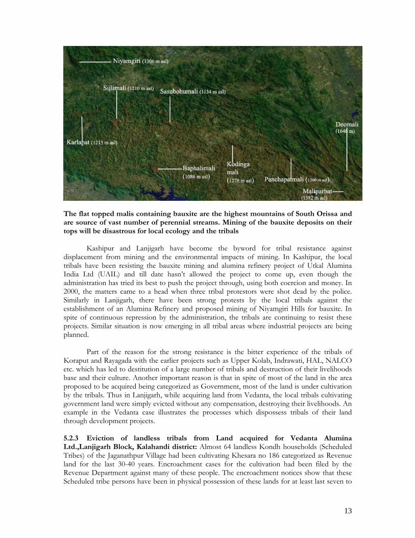
Picture 10: Satellite picture (picture covers approximately 1000 sq. km. area) of mining in Schedule V areas of Keonjhar district. Part of these areas is the homelands of Paudi Bhuiyans and Juangs, Primitive tribal group.
5.2.2 Bauxite: The major bauxite deposits are also located in scheduled areas in Kalahandi, Rayagada and Koraput districts with the major mining being done by NALCO on Panchapatamali of Koraput district. These have been a major source of controversy, with the local tribals opposing proposed mining projects tooth and nail, and the State Government using all possible strategies, including coercion and repression to make these deposits available to mining multinationals. The resistance of Kashipur tribals against UAIL’s mining project and alumina refinery has been going on for over 10 years now. Similarily, flashpoints are building up near proposed bauxite mining on Niyamgiri by Vedanta, Sunger by L&T, Kodingamali by Aditya Aluminium and Maliparbat by Hindalco. The bauxite deposits are all located on top of the highest mountains in South Orissa which are called Malis, and are sacred to tribals as they are source of large number of perennial streams. These streams are vital to local tribals as they are often the only source of water for drinking and irrigation of fields in summer season, and sustain the local agricultural economy. This realization has created massive resistance against bauxite mining amongst tribals. The major bauxite deposits of Orissa are given as below:
13
The flat topped malis containing bauxite are the highest mountains of South Orissa and are source of vast number of perennial streams. Mining of the bauxite deposits on their tops will be disastrous for local ecology and the tribals
Kashipur and Lanjigarh have become the byword for tribal resistance against
displacement from mining and the environmental impacts of mining. In Kashipur, the local tribals have been resisting the bauxite mining and alumina refinery project of Utkal Alumina India Ltd (UAIL) and till date hasn’t allowed the project to come up, even though the administration has tried its best to push the project through, using both coercion and money. In 2000, the matters came to a head when three tribal protestors were shot dead by the police. Similarly in Lanjigarh, there have been strong protests by the local tribals against the establishment of an Alumina Refinery and proposed mining of Niyamgiri Hills for bauxite. In spite of continuous repression by the administration, the tribals are continuing to resist these projects. Similar situation is now emerging in all tribal areas where industrial projects are being planned.
Part of the reason for the strong resistance is the bitter experience of the tribals of
Koraput and Rayagada with the earlier projects such as Upper Kolab, Indrawati, HAL, NALCO etc. which has led to destitution of a large number of tribals and destruction of their livelihoods base and their culture. Another important reason is that in spite of most of the land in the area proposed to be acquired being categorized as Government, most of the land is under cultivation by the tribals. Thus in Lanjigarh, while acquiring land from Vedanta, the local tribals cultivating government land were simply evicted without any compensation, destroying their livelihoods. An example in the Vedanta case illustrates the processes which dispossess tribals of their land through development projects. 5.2.3 Eviction of landless tribals from Land acquired for Vedanta Alumina Ltd.,Lanjigarh Block, Kalahandi district: Almost 64 landless Kondh households (Scheduled Tribes) of the Jaganathpur Village had been cultivating Khesara no 186 categorized as Revenue land for the last 30-40 years. Encroachment cases for the cultivation had been filed by the Revenue Department against many of these people. The encroachment notices show that these Scheduled tribe persons have been in physical possession of these lands for at least last seven to

14
eight years. However, the tribals claim that even their forefathers were cultivating the land. Both as per the principal of adverse possession and as per the section 7(a) of Orissa prevention of Land Encroachment Act, 1972, such land should have been settled with the landless persons to the extent of one standard acre (equivalent to 4.5 acres of uplands). The last revisional Survey and Settlement of Lanjigarh block took place in the late eighties, and the tribals claim that when they tried to get the land regularized in their names, they were asked to pay bribes up to Rs. 5000/- per acre, which they couldn’t afford. Even after the settlement, they have been trying to get the land regularized through revenue department, but have been asked for bribes by the Revenue department personnel.
In 2003, instead of settling this land with the tribal cultivators cultivating these lands, the
district administration summarily evicted these 64 families by force without any compensation, thereby taking away their main source of livelihoods. The land has been handed over by the district administration to Vedanta Alumina Ltd. for the construction of their rehabilitation colony. In law, this action violates not only the rule of adverse possession and section 7(a) of OPLE, 1972 but it also it violates the protection provided to the Scheduled tribes in Schedule V of the Constitution and the section 3(iii) of the OSATIP Regulations (1956) by turning scheduled tribes “effectively” landless. The section 3(iii) of OSATIP regulation (1956) provides a minimum benchmark of 2 acres of irrigated or five acres of unirrigated land for ownership by scheduled tribes before any land is their possession can be transferred. By not recognizing their cultivation rights and by evicting landless scheduled tribe persons from the land cultivated by them for generations, the provision is violated.
Non-settlement of government land cultivated by them is one of the most common
complaints by tribals. Regularization of encroachments invariably requires speed money, and those who can’t pay, don’t get their land regularized either during the settlements or through the revenue administration.
6 Forests plantations and wild life sanctuaries: Insensitive and bureaucratic conservation programs have emerged as another major threat to tribals in scheduled V areas. Almost 46% of the land in scheduled areas has been categorized as forests without proper survey and settlements, and thousands of square kilometers of shifting cultivation areas as well as permanent cultivation areas have been included as under forest category (Kumar et al, 2005).
Plantations were the preferred tactics of the Forest Department and Revenue
Department to evict cultivators from these lands since the 1960s, leading to continuous conflicts with tribals. The trend continues even now. For example, in last five years, Forest Department has taken up an incredible 52,800 ha of plantations in the undivided Koraput district only. Much of this plantation is taken up on land already being cultivated or under shifting cultivation by tribals. The lack of legal title of tribals on most of the land cultivated by them aggravates this situation. An example of the processes involved and resultant injustices on tribals is give as below.
6.1 Compensatory afforestation in Kadalibadi, Juangpirh, Keonjhar: In Kadalibadi, a Juang village in Keonjhar, compensatory afforestation has led to displacement of Juang tribals, a PTG, from their customary swidden land not recorded in their names. In this village, only 25 ha out of total a 283 ha in the village is legally available to the village residents. 37 out of 44 families hold 25 ha. with an average holding size of only 0.66 ha. The access to agricultural land is seen to worsen further when the types of holdings are analyzed. It shows an abysmally low holding of 0.09 ha of paddy land per household, 0.21 ha of other land including homestead and 0.36 ha of

15
orchard land (bagayat). The households have only usufructory rights on the orchard lands (43% of total holdings).
During 1993-1999, 77.186 ha7 (27% of the village area) was leased to Forest
Department to carry out plantations. This area of 77.186 ha has been diverted from uncultivable waste land of the Village lying under the control of Revenue Department. Plantations have already been carried out in these lands. In 2005, another 43 ha. (12 % of village area) in the village have been leased out to Forest Department for compensatory afforestation for Ingani Jharan Mining Company. Compensatory afforestation is taken up under the Forest Conservation Act, 1980 in case of diversion of forest land to non-forest use such as mining, reservoirs etc. The land which is afforested has to be recategorised as forest land.
The series of plantations on their customary have been a double tragedy for the hapless
Juangs. Even though they didn’t get legal rights on their communal land, they continued to treat it as such and were cultivating these lands. Conversion of major part of their communal lands into plantations by Forest Department deprived them of the access to these swidden lands and has pushed them to starvation levels. The tragedy has been aggravated because the patch selected for the plantation in 2005 is the largest and the most important shifting cultivation patch called Bagiatal. The Juangs were also planning to create permanent paddy land in part of this patch through diverting a local stream. With the compensatory afforestation, this land has effectively become forest land, closing all possibilities of Juangs ever being able to reclaim it. No swidden paddy cultivation has been taken up this year by the Juangs, and starvation looms in their faces.
The above process has violated many laws, apart from its ethical and social justice
implications. The most important violation is that of the Schedule V of the constitution which enjoins the State to protect the Scheduled tribe’s rights in land. The section 3(iii) of the OSATIP Regulations (1956) is also violated by turning scheduled tribes “effectively” landless. This section provides a minimum benchmark of 2 acres of irrigated or five acres of unirrigated land for ownership by scheduled tribes before any land is their possession can be transferred. By not recognizing their cultivation rights and by evicting scheduled tribe persons from the land possessed and cultivated by them for generations, this provision is violated. Both as per the principal of adverse possession in Orissa Land Reforms Act, 1960 and as per the section 7(a) of Orissa prevention of Land Encroachment Act, 1972, such land should have been settled with the landless persons to the extent of one standard acre (equivalent to 4.5 acres of uplands).
Similar situation is found in many other tribal villages where plantations have been carried
out. Recently eleven tribal women from Nandupalla village of Balangir district were arrested because they opposed Forest department attempts to carry out plantations on land being cultivated by them for last five decades.
6.2 Protected areas (Wildlife sanctuaries and National parks): Almost 8111.55 sq. km. (5%) of Orissa have been declared as protected areas (Sanctuaries and National Parks). Most of these protected areas are in the Scheduled V areas or in areas where tribal population is high8. Apparently another 18 protected areas are in the pipeline. The Wildlife Protection Act, 1972 is a strong regulatory statute which restricts almost all activities inside Protected Areas. These include restrictions on entry to sanctuary (Section 27), removal of forest products including NTFPs (except for bonafide self consumption), regulation or prohibition of grazing
7 khata no 32/1 in ROR of Kadalibadi, Telkoi Tehsil, Keonjhar Sub-Division, Keonjhar District http://bhulekh.ori.nic.in 8 Please see annexure I for a list of protected areas.

16
or movement of livestock etc. This effectively exiles people living inside the protected area from civilization, with restrictions on movement of goods and services.
More than 700 villages are still inside the existing sanctuaries. Apart from these, a large
number of unsurveyed villages and settlements exist inside these sanctuaries, mostly of tribal communities, which are treated as encroachments. However, these villages have existed inside the sanctuaries for generations.
A Satellite picture of area inside Kotgarh Sanctuary shows the extensive areas of cultivation, both settled and shifting. The Kotgarh sanctuary is home of Kutia Kondhs, a PTG. Many of their villages have not even been surveyed and are treated as encroachments As per the WPA, 1972, many of the villages are supposed to be evicted from the sanctuary areas. Even where they are not being evicted, collection of NTFPs and other forest products are totally restricted, making livelihoods extremely difficult. This has been the cause of regular conflict and has led to impoverishment of people living inside these areas. The powers granted to the Forest department under the WPA, 1972, also helps them in harassing and exploiting the tribals and other marginalized sections. 7 Conclusions: The poverty and marginalization of tribals has been a historical process aided by the State formation and extension, and has led to marginalization and impoverishment of a large section of society. Structural factors constraining access to land and forests have played an important and fundamental role in the marginalization process. Larger political factors frame these structural constraints which need to be addressed through political processes.

17
Annexure I Table II: Some Irrigation and industrial projects in scheduled areas of Orissa Name Area (ha) No. of hhs
affected Tribals hhs as % of total HHs affected
Source
Machkund 6477 2938 1500 (51%) Fernandes et al, 1992 Salandi 1229 589 552 (93%) Dalua, 1991 Balimela 17496 1900 1507 (79%) Diwakar, 1982 Upper Kolab 11350 3179 1421 (44.7%) GOI, 1993 Indrawati 17263 5534 42% Ota Rourkela Steel Plant 7917 2367 1657 HAL, Sunabeda 3764 468 NA NALCO, Damanjodi 3444 788 398 M/s.Orissa Sponge Iron Ltd., Palspanga
176 NA NA
IPITATA, Joda 129 NA NA UAIL, Kashipur 862 NA NA Vedanta Alumina Lts, Lanjigarh
707 NA NA
M/s. Jindal Steel & Power Ltd.
94 NA NA
70908


![[XLS]kvsroranchi.org.inkvsroranchi.org.in/ANNOUNCEMENT/KVSRORANCHI1173.xlsx · Web viewPRAVEEN NAGESIA SUCHITRA KUMUD KUNDAN KUMAR KESHRI NUTAN CHAMPI NIDHI SINGH ANAMIKA BANERJEE](https://img.dokumen.tips/doc/110x75/5af396837f8b9a8c30915cea/xls-viewpraveen-nagesia-suchitra-kumud-kundan-kumar-keshri-nutan-champi-nidhi.jpg)