Embed Size (px)
Citation preview

Form 5 Submission on Plan Change 1 to Whakatāne District Council
Clause 6 of Schedule 1, Resource Management Act 1991
To:
The Chief Executive Whakatāne District Council
By email: [email protected] [email protected]
Name of submitter: Awatarariki Residents Incorporated (Society) ___________________________________________________________________________________
This is a submission on the whole of Whakatāne District Plan - Plan Change 1: Awatarariki Fanhead, Matatā. 1 I could not gain an advantage in trade competition through this submission.
2 I am directly affected by an effect of the proposed change that adversely affects the environment.
3 The effect on the environment that I am directly affected by does not relate to trade competition or the effects of trade competition
4 The specific provisions of the proposed change that my submission relates to and the details of my submission are set out below.
5 I wish to be heard in support of my submission.
6 If others make a similar submission, I will not present a joint case with them at a hearing.
Signed: Date 17 September 2018 Rick Whalley Rob Enright/ Ruby Haazen Chairperson of Awatarariki Residents Incorporated Counsel for the Society 10 Clem Elliot Drive Matatā

Electronic address for service of submitter:
Email:
Telephone: 021 304 622 Daytime: 021 304 622 After Hours: Fax:
Postal address (or alternative method of service under section 352 of the Act):
10 Clem Elliot Drive Matatā 3194
Contact Person: [name and designation, if applicable]
Rick Whalley Chairperson of Awatarariki Residents Incorporated Counsel Acting: Rob Enright / Ruby Haazen Barristers Magdalene Chambers Level 1, 28 Customs St East Britomart Auckland e: [email protected] e: [email protected]
A2818161 1
The specific provisions of the proposal that my submission relates to are: The Society’s submission relates to the entire Whakatāne District Plan - Plan Change 1: Awatarariki Fanhead, Matatā (PC1). My submission is: Identified below. My reasons: Identified below. I seek the following decision from the local authority:
(1) As first preference, withdraw PC1; or delete PC1 under s85 RMA. (2) As second preference, amend PC1 to address the matters identified in this submission, including the general and specific submission
points, and general and specific relief, outlined below.
(3) In addition to (1) and (2), if PC1 is confirmed so that residential activities in the Awataraiki High Risk Debris Flow Policy Area (high risk) have prohibited status (or require resource consent) then a direction under s85 RMA that the District Council acquire each of the high risk properties under the Public Works Act 1981, subject to the written consent of each individual property owner or person with an estate or interest in the relevant land.
GENERAL SUBMISSION POINTS 1 This submission is separated into general and specific submission points. Relief sought relies on both general and specific submission
points.
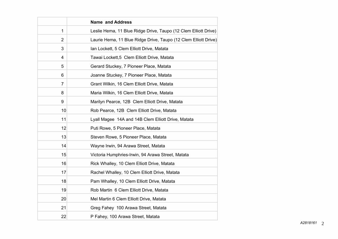
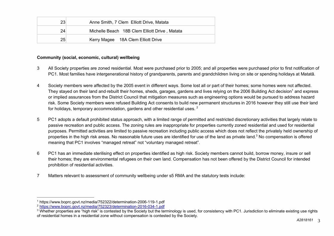
2 The Society has 25 members. All members are families that live permanently, have baches or vacant land within the high risk areas as follows:
A2818161 2
Name and Address
1 Leslie Hema, 11 Blue Ridge Drive, Taupo (12 Clem Elliott Drive)
2 Laurie Hema, 11 Blue Ridge Drive, Taupo (12 Clem Elliott Drive)
3 Ian Lockett, 5 Clem Elliott Drive, Matata
4 Tawai Lockett,5 Clem Elliott Drive, Matata
5 Gerard Stuckey, 7 Pioneer Place, Matata
6 Joanne Stuckey, 7 Pioneer Place, Matata
7 Grant Wilkin, 16 Clem Elliott Drive, Matata
8 Maria Wilkin, 16 Clem Elliott Drive, Matata
9 Marilyn Pearce, 12B Clem Elliott Drive, Matata
10 Rob Pearce, 12B Clem Elliott Drive, Matata
11 Lyall Magee 14A and 14B Clem Elliott Drive, Matata
12 Puti Rowe, 5 Pioneer Place, Matata
13 Steven Rowe, 5 Pioneer Place, Matata
14 Wayne Irwin, 94 Arawa Street, Matata
15 Victoria Humphries-Irwin, 94 Arawa Street, Matata
16 Rick Whalley, 10 Clem Elliott Drive, Matata
17 Rachel Whalley, 10 Clem Elliott Drive, Matata
18 Pam Whalley, 10 Clem Elliott Drive, Matata
19 Rob Martin 6 Clem Elliott Drive, Matata
20 Mel Martin 6 Clem Elliott Drive, Matata
21 Greg Fahey 100 Arawa Street, Matata
22 P Fahey, 100 Arawa Street, Matata
A2818161 3
23 Anne Smith, 7 Clem Elliott Drive, Matata
24 Michelle Beach 18B Clem Elliott Drive , Matata
25 Kerry Magee 18A Clem Elliott Drive Community (social, economic, cultural) wellbeing
3 All Society properties are zoned residential. Most were purchased prior to 2005; and all properties were purchased prior to first notification of
PC1. Most families have intergenerational history of grandparents, parents and grandchildren living on site or spending holidays at Matatā.
4 Society members were affected by the 2005 event in different ways. Some lost all or part of their homes; some homes were not affected. They stayed on their land and rebuilt their homes, sheds, garages, gardens and lives relying on the 2006 Building Act decision1 and express or implied assurances from the District Council that mitigation measures such as engineering options would be pursued to address hazard risk. Some Society members were refused Building Act consents to build new permanent structures in 2016 however they still use their land for holidays, temporary accommodation, gardens and other residential uses. 2
5 PC1 adopts a default prohibited status approach, with a limited range of permitted and restricted discretionary activities that largely relate to
passive recreation and public access. The zoning rules are inappropriate for properties currently zoned residential and used for residential purposes. Permitted activities are limited to passive recreation including public access which does not reflect the privately held ownership of properties in the high risk areas. No reasonable future uses are identified for use of the land as private land.3 No compensation is offered meaning that PC1 involves “managed retreat” not “voluntary managed retreat”.
6 PC1 has an immediate sterilising effect on properties identified as high risk. Society members cannot build, borrow money, insure or sell
their homes; they are environmental refugees on their own land. Compensation has not been offered by the District Council for intended prohibition of residential activities.
7 Matters relevant to assessment of community wellbeing under s5 RMA and the statutory tests include:
1 https://www.boprc.govt.nz/media/752322/determination-2006-119-1.pdf 2 https://www.boprc.govt.nz/media/752323/determination-2016-034-1.pdf 3 Whether properties are “high risk” is contested by the Society but the terminology is used, for consistency with PC1. Jurisdiction to eliminate existing use rights of residential homes in a residential zone without compensation is contested by the Society.

A2818161 4
(a) delay by the District Council in requesting notification of PC1, relevant to assessment of whether there is tolerable risk, and, to the extent that risk exists, whether it can be managed in less intrusive ways than prohibiting residential activity;
(b) a shifting position by Council on the extent of tolerable risk and degree of urgency for intervention. The Society says that there has been no change in risk profile between the 2005 event and notification of PC1 in 2018. Instead the District Council has changed its view of what is acceptable risk and now claims urgency due to fatality risk4, but was content to delay PC1 and related PC175 to the district plan for a number of years pending changes to the regional plan framework;
(c) failure by the District Council to competently manage hazard risk over the 13 years taken to notify PC1. Residents have been given inconsistent assurances about whether risk is tolerable or credible; inconsistent or incomplete explanations for rejecting engineered alternatives to manage risk, entitlement to fair compensation, lack of certainty about what will happen from 2021 when evicted;
(d) Flawed engagement with the community resulting in inadequate assessment of effects;
(e) These factors are relevant to assessment of credible risk because societal and community views of risk influence what is considered “tolerable”.
8 The PC1 managed risk regime is contrary to sustainable management and social, economic and cultural community wellbeing. It adopts a
risk avoidance regime, inconsistent with (or not giving effect to) Pt 2 RMA. It is a taking of property rights without compensation, abuse of public power and contrary to sustainable management.
Statutory provisions
9 PC1 is inconsistent with the relevant statutory provisions and Council’s statutory functions. It is not appropriate in terms of Pt 2, statutory
functions and tests under sections 30, 31, 32, s32AA, ss63-68, s85 and 1st Schedule RMA.. While there is a wider community interest in managing risk, affected property owners in the high, medium and low risk areas merit greatest weight when evaluating appropriate outcomes under the statutory framework and the relevant “community” affected.
4 Alleged fatality risk 5 Notified by the Regional Council at the District Council’s request

A2818161 5
Validity and jurisdiction
10 PC1 is unlawful and ultra vires Council’s statutory functions and powers:
a. Council’s statutory functions include control use of land for “avoidance or mitigation of natural hazards” (s31(1)(b)(i) RMA). The approach adopted to the high risk areas do not reflect this dual function. It is an avoidance regime, not a mitigation regime.
b. Section 85 RMA imposes a direct or indirect fetter on abuse of public power by the District Council. Rezoning existing residential land
without reasonable compensation, is an abuse of public power. It is contrary to public policy and relevant wellbeings and values in s5 and Pt 2 RMA. Lesser alternatives exist that manage or mitigate the hypothetical risks, without removing existing use rights.
c. It is inappropriate or unlawful to include a blanket prohibited status rule where all activities are prohibited unless identified as permitted
or restricted discretionary.
Planning instruments
11 To the extent relevant, PC1 does not give effect to the NZCPS.
12 PC1 does not give effect to, or reflect, the relevant provisions of the Regional Policy Statement including (but not limited to):
(a) Objective 31 RPS and Policy NH1B require “avoidance or mitigation of natural hazards”. PC1 is an avoidance, not mitigation, regime. Other policies should be read in light of the objective which contemplates mitigation.
(b) As to policies NH2B & NH3B, identification of properties as high risk is incorrect; alternatively, mitigation measures are available to reduce risk to tolerable levels. “Tolerable levels” is a qualitative; or qualitative and quantitative standard; and perspectives of homeowners as to what is acceptable risk are relevant to assessment of tolerable risk.
(c) Policy NH4 (urban development) has limited relevance; alternatively “managing” natural hazard risk does not require an avoidance (prohibited status) regime in the high risk areas.
(d) Policy NH5B (“avoid increasing risk”) does not apply to existing dwellings; and “encouraging” reduction of natural hazard risk does not require an avoidance (prohibited status) regime.
(e) Policy NH6B arguably supports retention of existing homes that have functional need for their location and provide significant benefits to the relevant community of interest.

A2818161 6
(f) Policies NH7A, NH8A, NH13C involve identification and assessment of hazard, not prohibition of residential activities.
(g) Policy NH12A (“promote”) is not directive for existing residential activities (“take into account..where practicable..” risk reduction
measures).
(h) Allowance should be made for residential activities specifically provided for by the Regional Policy Statement that inherently add to risk. Integrated management (30(1)(a) RMA) recognises that the establishment or continuance of residential activities in the coastal environment is provided for (albeit natural hazard risk needs to be managed).
(i) The policy and rules framework, requiring that people and their communities avoid living in high risk properties is inappropriate and
does not represent a reasonable response to the existing environment. (j) Subject to proof that the assessment of high risk is correct (not accepted or conceded by the Society) a regime that involves an
alternative means of risk avoidance or risk mitigation is required. PC1 does not reflect that dual focus in the relevant RPS Natural Hazards provisions. To the extent that properties are (as a matter of fact) “high risk”, then RPS Appendix M identifies a number of options for management of high risk areas.
(k) PC1 is not vertically and horizontally aligned with the operative District Plan including (without limitation) Chapter 18.1: Objective Haz1
(avoid or mitigate natural hazards); Policy 9 (manage the margins of streams to reduce the risk of damage from debris flow affecting townships).
S85 RMA
13 PC1 breaches s85 RMA because it makes the subject land owned by members of the Society:
(a) incapable of reasonable use; and (b) places an unfair and unreasonable burden on the owners of that land; (c) residentially zoned and developed land will be unable to be used for residential purposes; (d) grounds for directions under s85(3A) RMA are made out (deletion, modification, compensation) in the event that PC1 is confirmed in its
notified form. Alternatives
14 PC1 does not allow for lesser interventions and alternatives such as:

A2818161 7
a. mitigation of hazard risk while enabling Society members to remain living in their homes;
b. adopting an information based approach to managing hazard risk;
c. adopting an event based approach (such as early warning systems) to managing hazard risk;
d. PC1 does not provide appropriate cost-benefit analysis of engineering options for management of landslide and debris flow risk;
e. PC1 does not appropriately address a combination of management systems to address hazard risk, to reduce high risk (to the extent that it exists) to medium or low risk. A combination of methods might include (but is not limited to) catchment management, monitoring and early warning systems;
f. PC1 does not evaluate the extent to which historic land uses (such as the adjacent Council operated quarry, farming and logging) contributed to or caused the 2005 event, but may not continue to present objective hazard risk; the extent to which responsible statutory bodies have failed to undertake catchment maintenance (including Department of Conservation as landowner, Regional Council and District Council); and whether these are relevant to assessment of alternatives to avoid or mitigate risk.
Hazard and Risk Assessment
15 PC1 relies on imprecise modelling of risk of landslide and debris flow; imprecise modelling of probability of fatality or injury; and uncertain
science as to assessment of risk to NH3 properties identified as “high risk”. PC1 relies on inadequate analysis of probability and consequence. Risk assessments are based on inadequate data sets and involve speculative or unfounded assertions of risk of fatality to Society members and their families. The risk assessment is uncertain but the consequences to Society members and their families are both certain and unfounded. Prohibited status is a disproportionate response given difficulties with the risk assessments.
16 Risk involves probability plus consequence. A different approach to acceptability of risk is required in relation to existing residential activity, as distinct from land use planning for future residential use. This is not reflected in the prohibited status regime for existing residential activities identified as high risk. As noted, “tolerable levels” is a qualitative; or qualitative and quantitative standard; and perspectives of homeowners as to what is acceptable risk are relevant to assessment of tolerable risk.
17 PC1 relies on Australian Geomechanics Standards6, that include significant qualifiers as to relevance and application for existing use
scenarios where sensitive users already occupy land identified as subject to potential hazard, and reasonably available alternative methods
6 Journal and News of the Australian Geomechanics Society Volume 42 No 1 March 2007

A2818161 8
exist for hazard mitigation. It is uncertain whether the Australian Guidelines are the most appropriate standard to apply. The Guidelines relevantly state:
“9 Reliability of landslide zoning for land use planning 9.1 Potential sources of error 9.1.1 Description There are a number of potential sources of error in the zoning process. These include:
• Limitations in the landslide inventory upon which the susceptibility and hazard zones maps are based. • Limitations in the stability of temporal series. For example the relationship between the triggering factor (e.g. rainfall) and
the frequency of landslides may change if the area is deforested. • Limitations in the level of detail available of topography, geology, geomorphology, rainfall and other input data. • Model uncertainty, meaning the limitations of the methods used to relate the inventory, topography, geology,
geomorphology and triggering events such as rainfall to predicting landslide susceptibility, hazard and risk. • Limitations in the skill of the persons carrying out the zoning.
It must be recognised that landslide zoning is not a precise science and the results are only a prediction of performance of the slopes based on the available data. In general, intermediate or advanced level zoning will be less subject to error than preliminary level zoning with each done at a suitable zoning map scale.”
GENERAL RELIEF 18 Based on the matters outlined in this submission, the Society seeks the following relief:
(1) As first preference, withdraw PC1; or delete PC1 under s85 RMA. (2) As second preference, amend PC1 to address the matters identified in this submission, including the general and specific submission
points, and general and specific relief, outlined below.
(3) In addition to (1) and (2), if PC1 is confirmed so that residential activities in high risk areas have prohibited status (or require resource consent) then a direction under s85 RMA that the District Council acquire each of the high risk properties under the Public Works Act 1981, subject to the written consent of each individual property owner or person with an estate or interest in the relevant land.

A2818161 9
SPECIFIC SUBMISSION POINTS & SPECIFIC RELIEF:
Specific provisions Details of submission: whether you support or oppose the specific provisions or wish to have them amended
Page No
Reference (e.g. Objective, Policy or Rule
number)
Support/Oppose
Decision Sought Say what changes to the plan change you
would like Give precise details
Include reasons for your views
2
3.2.5 Awatariki Debris Flow Policy Area 3.7.25
Oppose
(a) Withdraw PC1; or
(b) Delete 3.2.5 and delete amendment to
3.7.25; or
(c) Reclassify high risk areas as medium/low risk areas.
PC1 does not promote sustainable management, is unlawful or breaches the statutory framework. Refer General Reasons above.
3
Policies 18, 19
Oppose Policies 18, 19
(a) Withdraw PC1; or (b) Delete Policies 18 & 19; or (c) Delete reference to high risk areas; or (d) include new policy that requires provision
for social, economic and cultural wellbeing of owners and occupants of properties in the high, medium and low risk areas.
PC1 does not promote sustainable management, is unlawful or breaches the statutory framework. Alternative methodologies may be appropriate. Refer General Reasons above.

A2818161 10
3 3
Rule 18.2.6.3 , 18.2.6.4, 18.2.6.5 Activity Status table 3.4.1.1
Oppose Oppose change to prohibited status
Delete Rules 18.2.6.3, 18.2.6.4 & 18.2.6.5 and retain the activity status under the relevant Residential zone. Amend PC1 to include methods and rules regime identified below. These are listed as alternatives, but a rules regime may include a combination of these. Amending PC1 to include the rules and other methods listed below may require additional issues, objectives and policies to be included in PC1 to ensure vertical and horizontal integration:
(a) No restrictions on residential activities for high and medium risk properties. Mitigation options limited to non-regulatory or non rule-based methods to avoid and manage hazard risk such as educative or early warning systems; and/or
(b) A grandparenting regime for high and medium risk properties:
(c) permitted status for residential activities for high risk properties where residential activity was established prior to notification of PC1;
(d) controlled status for any increase or change in character, intensity and scale of existing residential activities in high risk properties;
(e) As alternative to (i), delete prohibited status and substitute controlled status for residential activities for high risk properties. Limit controlled status criteria to presence of early warning detection
PC1 does not promote sustainable management, is unlawful or breaches the statutory framework. Refer General Reasons above. PC1 does not promote sustainable management, is unlawful or breaches the statutory framework. Refer General Reasons above.

A2818161 11
system or equivalent for credible landslide or debris flow events; and/or
(f) Methods (which may include rules) that
require the District Council to establish a hazard identification and monitoring regime to provide an early warning system for owners and occupants of high risk properties in the event of a credible landslide or debris flow event; and/or
(g) Without prejudice to grounds stated and above relief, if the decision-maker decides that prohibited status is appropriate having regard to the statutory criteria, then introduce an environmental compensation and offsetting regime that involves payment to owners of high risk properties of reasonable compensation for changing residential activities to prohibited status.
(h) Introducing rules and other methods that require payment of reasonable mitigation, environmental offsetting and/or environmental compensation by the District Council to the owners of high risk properties as a consequence of the intended prohibited status rule for residential activities. Such a rules regime may require Augier undertakings by the Regional or District Council to be enforceable; or may involve condition precedents for the rules framework (and change in activity status of residential activities) to be triggered.
(i) Methods for calculation of mitigation, offsetting and/or environmental
A2818161 12
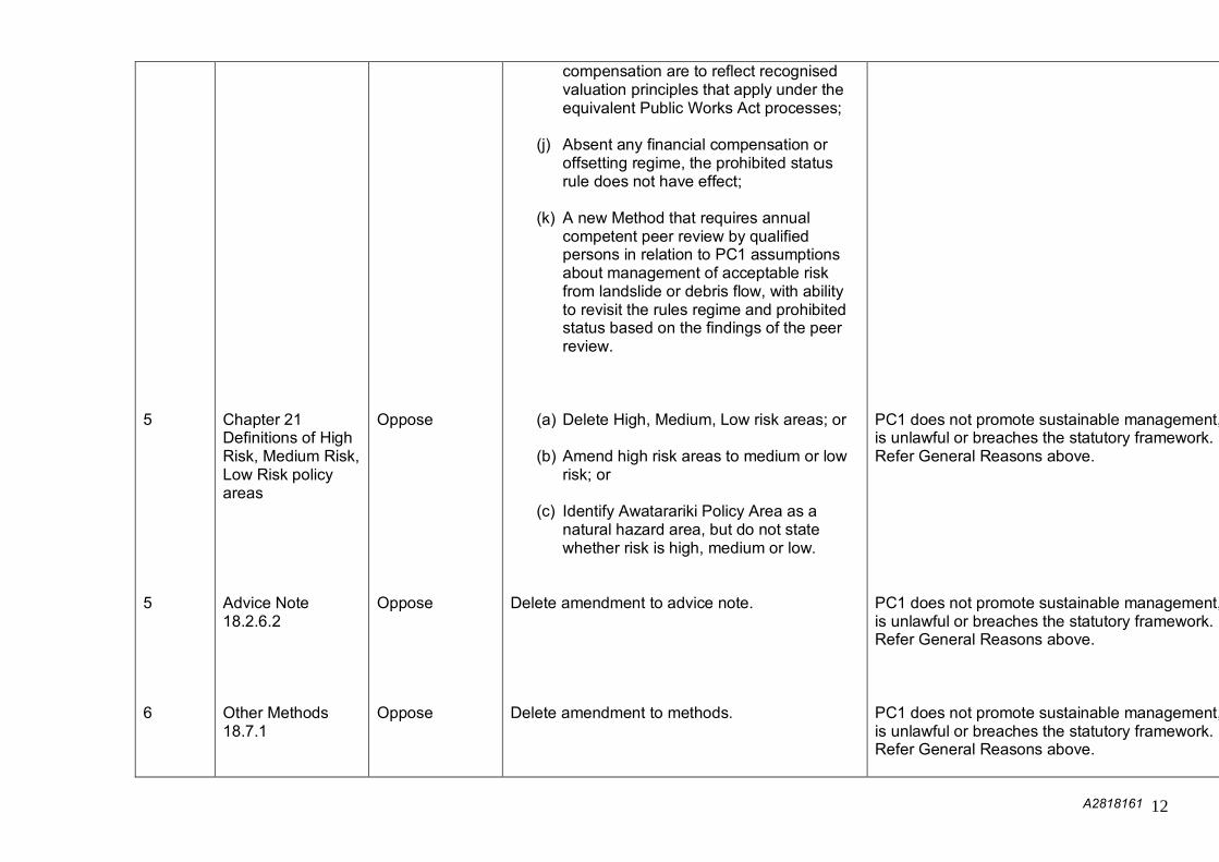
5 5 6
Chapter 21 Definitions of High Risk, Medium Risk, Low Risk policy areas Advice Note 18.2.6.2 Other Methods 18.7.1
Oppose Oppose Oppose
compensation are to reflect recognised valuation principles that apply under the equivalent Public Works Act processes;
(j) Absent any financial compensation or offsetting regime, the prohibited status rule does not have effect;
(k) A new Method that requires annual competent peer review by qualified persons in relation to PC1 assumptions about management of acceptable risk from landslide or debris flow, with ability to revisit the rules regime and prohibited status based on the findings of the peer review.
(a) Delete High, Medium, Low risk areas; or
(b) Amend high risk areas to medium or low
risk; or
(c) Identify Awatarariki Policy Area as a natural hazard area, but do not state whether risk is high, medium or low.
Delete amendment to advice note. Delete amendment to methods.
PC1 does not promote sustainable management, is unlawful or breaches the statutory framework. Refer General Reasons above. PC1 does not promote sustainable management, is unlawful or breaches the statutory framework. Refer General Reasons above. PC1 does not promote sustainable management, is unlawful or breaches the statutory framework. Refer General Reasons above.

A2818161 13
N/A
Planning Maps
Oppose
(a) Reject amendment to planning maps; or (b) Delete high risk and substitute with
medium or low risk areas; or (c) Identify Awatarariki Policy Area as a
natural hazard area, but do not state whether risk is high, medium or low.
PC1 does not promote sustainable management, is unlawful or breaches the statutory framework. Refer General Reasons above.

Form 5 Submission on notified proposal for policy statement or plan, change or variation
Clause 6 of Schedule 1, Resource Management Act 1991
To: Whakatāne District Council Name of submitter: Russell George, Chair – Bay of Plenty CDEM Coordinating Executive Group This is a submission on the following change proposed to the plan: Whakatāne District Plan - Plan Change 1: Awatarariki Fanhead, Matatā Trade Competition I could not gain an advantage in trade competition through this submission.
If you could gain an advantage in trade competition through this submission, please answer the following: I am/am not* directly affected by an effect of the subject matter of the submission that—
(a) adversely affects the environment; and (b) does not relate to trade competition or the effects of trade competition. [*Select one]
The specific provisions of the proposal that my submission relates to are:
Support is given to change the Operative Whakatāne District Plan to:
Include an Awatarariki Debris Flow Policy Area and show high, medium, and low risk areas in this policy area on the District Plan Planning Maps.
Rezone the high risk area to Costal Protection.
Introduce a new policy framework and rules to manage the identified natural hazard risk.
My submission is:
Please see full submission attached I seek the following decision from the local authority: Adopt Proposed Plan Change 1 to the Whakatāne District Plan – Awatarariki Fanhead, Matatā Hearing submissions I wish to be heard in support of my submission.
If others make a similar submission, I will consider presenting a joint case with them at a hearing. Signature of submitter (or person authorised to sign on behalf of submitter) Date: 13 September 2018 (A signature is not required if you make your submission by electronic means.) Contact Details

Electronic address for service of submitter: [email protected] [email protected]
Telephone: 027 742 7349 Postal address: PO Box 364, Whakatāne 3158 Contact person: Matthew Harrex, Manager Planning and Development, Emergency Management Bay of Plenty
Note to person making submission If you are a person who could gain an advantage in trade competition through the submission, your right to make a submission may be limited by clause 6(4) of Part 1 of Schedule 1 of the Resource Management Act 1991. Please note that your submission (or part of your submission) may be struck out if the authority is satisfied that at least one of the following applies to the submission (or part of the submission):
it is frivolous or vexatious:
it discloses no reasonable or relevant case:
it would be an abuse of the hearing process to allow the submission (or the part) to be taken further:
it contains offensive language:
it is supported only by material that purports to be independent expert evidence, but has been prepared by a person who is not independent or who does not have sufficient specialised knowledge or skill to give expert advice on the matter.

Our Ref: A2900426 13 September 2018 Dear Sir/Madam
Proposed Plan Change 1 to the Whakatāne District Plan – Awatarariki Fanhead, Matatā
Proposed plan change 17 (Natural Hazards) to the Regional Natural Resources Plan
The Bay of Plenty Civil Defence Emergency Management Group (Bay of Plenty CDEM Group) is established under The Civil Defence Emergency Management Act 2002 (The CDEM Act 2002). The CDEM Act 2002 requires every regional council and every territorial authority within that region to unite to establish a Civil Defence Emergency Management Group. Members of the Bay of Plenty CDEM Group are:
Bay of Plenty Regional Council Kawerau District Council Ōpōtiki District Council Rotorua Lakes Council Tauranga City Council Western Bay of Plenty District Council Whakatāne District Council
This submission has been prepared on behalf of the Bay of Plenty CDEM Group. It has been approved by the Bay of Plenty Civil Defence Emergency Management Coordinating Executive Group. Recognising the joint approach required to address the natural hazard risks at Matatā, a single submission has been prepared in support of both Proposed Plan Change 1 to the Whakatāne District Plan – Awatarariki Fanhead, Matatā and Proposed Plan Change 17 (Natural Hazards) to the Regional Natural Resources Plan. The Bay of Plenty CDEM Group recognises the long and complex process that has lead all parties to reach this point. Considerable work has been undertaken to assess the hazard and risk associated with debris flow in the Awatarariki Fanhead at Matatā. This process and the assessment of risk management options are well detailed in the Section 32 Evaluation Report prepared for Whakatāne District Council. The Bay of Plenty CDEM Group appreciates the impact and stress that the proposed approach will have on property owners and sympathises with the position that they have found themselves in. The Bay of Plenty CDEM Group considers that these impacts are outweighed by the potential adverse effects of a future event and supports the proposed action taken to manage this risk. The Bay of Plenty CDEM Group also supports the managed voluntary retreat strategy running in parallel with this process. S17 of the CDEM Act 2002 requires CDEM Groups and each member to identify assess and manage hazards and risks; consult and communicate about risks and identify and implement cost effective risk reduction.
2
The Bay of Plenty CDEM Group Plan 2018-2023 sets out the reduction objectives for the Bay of Plenty CDEM Group to:
Build the community’s knowledge and understanding of their hazards and risks so they can make informed decisions.
Manage natural hazards through a risk-based approach. Increase the region’s environmental and infrastructure resilience.
Support is given to change the Operative Whakatāne District Plan to:
Include an Awatarariki Debris Flow Policy Area and show high, medium, and low risk areas in this policy area on the District Plan Planning Maps.
Rezone the high risk area to Costal Protection. Introduce a new policy framework and rules to manage the identified natural hazard risk.
Support is given to change the Operative Regional Natural Resources Plan to:
Add a new objective and new policies that set the intention to reduce the natural hazard risk on the Awatarariki Fanhead.
Add a rule prohibiting residential activities within high risk areas with effect after 31 March 2021.
Both proposed plan changes outlined above are consistent with The CDEM Act 2002 and the objectives of the Bay of Plenty CDEM Group Plan 2018-2023. The Bay of Plenty CDEM Group considers the Section 32 Evaluation Report prepared for Whakatāne District Council provides a thorough assessment of the options available to both Whakatāne District Council and Bay of Plenty Regional Council to manage the risk associated with debris flow on the Awatarariki Fanhead. Specifically the Bay of Plenty CDEM Group supports the assessment of warning and evacuation as a tool to reduce the risk on page 39 of the report. The Bay of Plenty CDEM Group agrees with the assessment that a warning system cannot be relied upon to provide dependable warnings, with adequate time, to sufficiently reduce the risk to life for residents. The Bay of Plenty CDEM Group wishes to be heard in support of this submission and has nominated Russell George to speak on behalf of the Bay of Plenty CDEM Group with regard to this submission. Sincerely
Russell George Chair Bay of Plenty Civil Defence Emergency Management Coordinating Executive Group

Form 5 Submission on notified proposal for policy statement or plan,change or variation
Clouse 6 of Schedule 1, Resource Management Act 1991
To: Whakatane District Council
Name of submitter: i r t / 7 / 1 ( T r z )[full name]
This is a submission on the following change proposed to the plan:Whakatane District Plan, Plan Change 1— Awatarariki Fanhead, Matata
Trade CompetitionI willi/could not* gain an advantage in trade competition through this submission.[*Select one]If you could gain an advantage in trade competition through this submission, please answerthe following:1 am/am not* directly affected by an effect of the subject matter of the submission that—(a) adversely affects the environment; and(b) does not relate to trade competition or the effects of trade competition.[*Select one]
The specific provisions of the proposal that my submission relates to are [give details]:
f l ' s 4 _ 6 7−7E , s e / ' J Ci7"71−71E 2 / /94 c 77−f−Z57−id?hilp:A/7"−− / /1/49'2. ef−rzi, /Si< ) " y r s /41−7t) 29 2 ,
2 4 c i a y f
My submission is: [include whether you support or oppose the speqk provisions or wish tohave them amended; and reasons for your views]
CefrilidcE
/ / t i /73− 6#117−1, 77j
AV− / " , ' 44/dt4o/− −iizv/ I P r f r t 07ite−eS
c,−77 0 ) 0 3 /;−17 6 d i t− E eel",//,/ 77 72)
−77−fr" /74−e0 4/et) ii/44−00,,f /5W −6− (7,1,/ / e n e _ 447.1v−rt/,‘47,0if E vi/−1)6−Aice −7−4−4/−z−777−e4 rfe−−„is−cy−ivs 0,d
See−i−LE

I seek the following decision from the local authority: [give precise details]
5Fel−c 77/−4−r− Prz5* e−oivre,v7 (../7−−/−fe,ve / R / 4 4 0 ( / 6− 7−WS
14/9 −A1 C17,474−AT fry' /975 "..1 77R e 4 , ) A , 7− I.
7)#n E ' s 77/4− t 76−: s,gee'A/ 77,79−7−77/15 /414, c i , , E ,,e.„"( /me:ow1/5 A.4714.,/v.on.),,,rnA71,04,i
• c i s Foier/if−,. . 0 E C i f/ x i S ,A7. Es 6 6 , 4 5 / t o 0 I V
itl−g /1−7−6
Hearing submissionsI w i s h A f f i f f i g e to be heard in support of my submission. [*Select one]
If others make a similar submission, I 101(will not* consider presenting a joint case with themat a hearing. [*Select one]
Signature of submitter (or person authorised to sign on behalf of submitter)
Date: if−−
Contact Details
Electronic address for service of submitter: if −k:6;t
Telephone: 0 2 / / 4 / 3 / / /
Postal address: 55− #V'" ES ST− ci; ev 0
− 2 4 3SZ. 'Contact person:
[name and designation, if applicable]
Note to person making submissionIf you are a person who could gain an advantage in trade competition through the submission, your right to make asubmission may be limited by clause 6(4) of Part 1 of Schedule 1 of the Resource Management Act 1991.
Please note that your submission (or part of your submission) may be struck out if the authority is satisfied that at least one ofthe following applies to the submission (or part of the submission):• it is frivolous or vexatious:• it discloses no reasonable or relevant case:• it would be an abuse of the hearing process to allow the submission (or the part) to be taken further:• it contains offensive language:

• it is supported only by material that purports to be independent expert evidence, but has been prepared by a personwho is not independent or who does not have sufficient specialised knowledge or skill to give expert advice on the
matter.

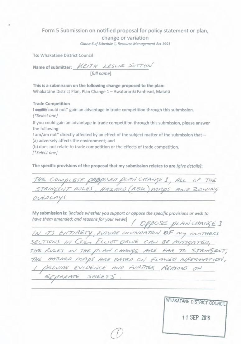
SUBMISSION ON PLAN CHANGE 1 TO THE WHAKATANE DISTRICT PLAN
When i t o l d my mother what was i n the proposed plan change she j u s t said , ibrought my sections as r e s i d e n t i a l , i f they want t o change t h a t , t h e n they havet o buy them o f me, and t h a t i s exact ly what i s going t o happen, she has signedup f o r the r e t r e a t package so move forward wi th t h a t f i r s t , then t h i s totalabuse o f peoples r igh ts w i l l not be necessary.
By neglecting t h e i r r e s p o n s i b i l i t i e s council have already removed my mothersr i g h t t o rebui ld her home o f 21 years ( a t time o f May 2005 event) .R/C conditionswere put i n place t o enable t h a t t o happen but council ignored them (appendix A)and now through t h i s plan change want t o remove a l l other r igh ts t o the pointshe w i l l not even be able t o camp the n ight on her p r i v a t e l y owned 2 acres,which under section 85/R.M.A i would have thought would pass as reasonable use .
I wish the consent author i ty t o throw out the proposed plan change 1 i n itse n t i r e t y u n t i l a f t e r the voluntary r e t r e a t package has been worked through fora l l residents and land owners on the fanhead , the options i n the plan changehave been watered down t o s ta te council may only buy out houses leavinglandowners with worthless C.P.Z land should the plan change happen , so stop itnow , currenly there i s no C.P.Z i n the d i s t r i c t plan t h a t t o t a l l y covers everyinch o f someones pr iva te property leaving them with no r igh ts . The plan changei s f u l l o f new Awatarar ik i high r i s k debris f low pol icy area rules t h a t go waypast what i s f a i r and reasonable, so i ask f o r the e n t i r e plan changes removal.
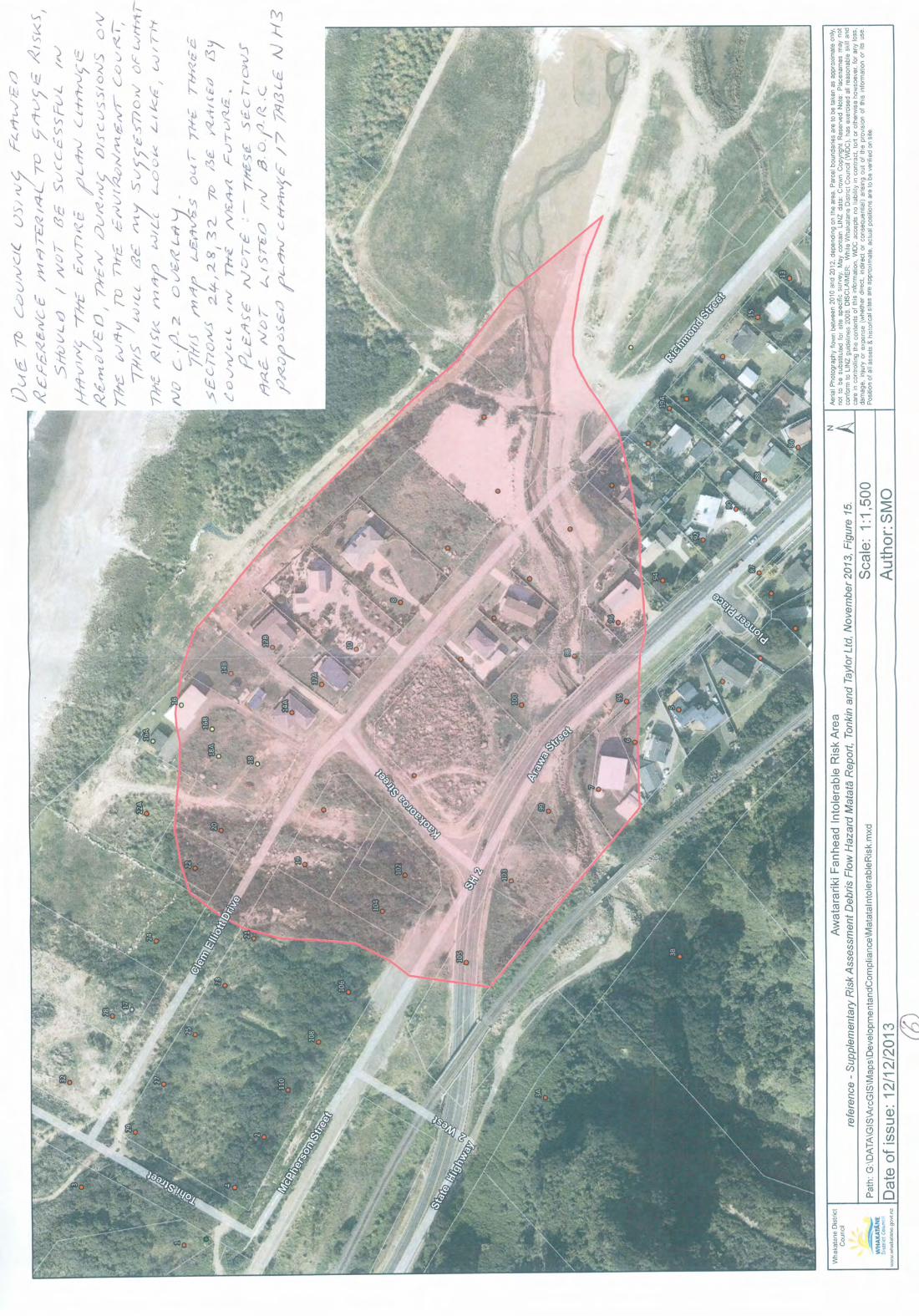
The proposed plan change also includes high r i s k area maps t h a t are based onflawed reference mater ia l where i t i s believed t h a t there had been previousdebris flows as large as the May 2005 event , which i s untrue , (appendixB)please read the evidence on the old r i v e r bed and i ask you t o through out theplan change 1 and i t s r i s k maps i n t h e i r entirety.
When you have f in ished reading the appendices you may wonder why t h i s i s onlycoming t o l i g h t now , w e l l i n the past we were working alongside council tof i n d an amicable solut ion t o the problem but now council have brushed us asideand are going foward with a plan change t h a t i s i n no way i n my mothers bestinterests.
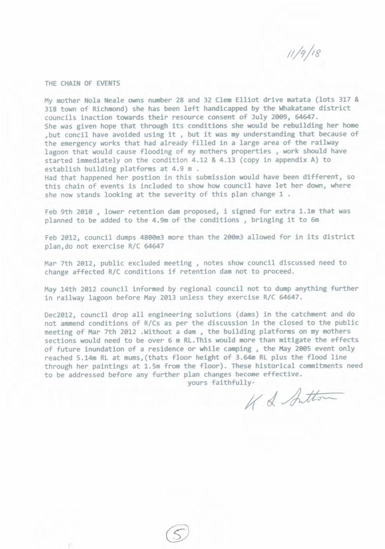
THE CHAIN OF EVENTS
My mother Nola Neale owns number 28 and 32 Clem E l l i o t d r i v e matata ( l o t s 317 &318 town o f Richmond) she has been l e f t handicapped by t h e Whakatane districtcouncils inact ion towards t h e i r resource consent o f July 2009, 64647.She was given hope t h a t through i t s conditions she would be rebui ld ing her home,bu t conch l have avoided using i t , but i t was my understanding t h a t because ofthe emergency works t h a t had already f i l l e d i n a la rge area o f the railwaylagoon t h a t would cause f looding o f my mothers propert ies , work should havestar ted immediately on the condition 4 .12 & 4 . 1 3 (copy i n appendix A) toestabl ish bui ld ing platforms a t 4 . 9 m .Had t h a t happened her postion i n t h i s submission would have been d i f f e r e n t , sot h i s chain o f events i s included t o show how council have l e t her down, whereshe now stands looking a t the sever i ty o f t h i s plan change 1 .
Feb 9th 2010 , lower re tent ion dam proposed, i signed f o r ex t ra 1.1m t h a t wasplanned t o be added t o the 4.9m o f the conditions , bringing i t t o 6m
Feb 2012, council dumps 4800m3 more than the 200m3 allowed f o r i n i t s districtplan,do not exercise R/C 64647
Mar 7th 2012, public excluded meeting , notes show council discussed need tochange af fec ted R/C conditions i f re tent ion dam not t o proceed.
May 14th 2012 council informed by regional council not t o dump anything furtheri n ra i lway lagoon before May 2013 unless they exercise R/C 64647.
Dec2012, council drop a l l engineering solutions (dams) i n the catchment and donot ammend conditions o f R/Cs as per the discussion i n the closed t o the publicmeeting o f Mar 7th 2012 .Without a dam , the bui ld ing platforms on my motherssections would need t o be over 6 m RI . This would more than mi t iga te the effectso f f u t u r e inundation o f a residence o r whi le camping , t h e May 2005 event onlyreached 5.14m RL a t mums,(thats f l o o r height o f 3.64m RI plus the f lood linethrough her paint ings a t 1.5m from the f l o o r ) . These h i s t o r i c a l commitments needt o be addressed before any f u r t h e r plan changes become effective.
yours faithfully−
//r

AilO/K

free,Avi 7 7 i e COA/C) /0 ) % t i S O 0 re c
s i n c e o l 4 i 2 irt−'7b
4.5 Any earth spillages onto the road reserve shall be cleareImmediately to avoid runoff into drains or cesspits. Andamage to the road or Council services shall be remedied tthe satisfaction of the Director Environment and PolicyTransit New Zealand as the case may be.
4.6 At all times earthworks are being carried out on site, thconsent holder shall ensure compliance with rule 4.3.15(a) a fthe Proposed Whakatane District Plan by ensuring noise leveare kept in compliance with the performance standaspecified under NZS 6803:1991, Acoustics, Construction Nois
4.7 Earthworks and construction work on site shall be restrictedthe hours of:
7.00 am to 6.00 pm—Monday to Friday; and8.00 am to 12.00 noon—Saturdays;
No work Is to be undertaken on Sundays and public holidays.
The above hours of operation do not apply to any measunecessary for storm water/surface water and dust mitigatiomeasures.
4.8 No inorganic materials that do not naturally occur in thimmediate area shall be deposited on the site but shall btransported to an authorised waste disposal facility f rdisposal.
4.9 All machinery shall be m fuelled on site at a dedicatedfuelling site located no closer than 30m from the debris mounbatter slopes or within lagoon wetland area. Control faccidental spillage and decontamination mitigation shall fopart of the management plan for contaminated material.
4.10 Provision shall be made to the satisfaction of Ontrack anTransit New Zealand for the control of drainage from existinculverts in the railway embankment and for overland flopaths that may be affected by new areas of deposited debris.
N t , 4.11 A work permit shall be obtained from Ontrack prior tcommencing any work within the railway premises.
OF 12 Works shall be undertaken on Allotments 316, 317 and 31Town of Richmond to ensure that the building platform with!
s
/q.t.° 7174,R_Sc e c 770"J c

I
−pit−5 4. 9. it−I ",,3s 7t, −136coi−−, E # 6 " #060tope−_,.vv ix
4 )if−
AIw i frff
A,4−−, e−R f.e f p Dter)•−− 7 0 7 c−,DiJsE"r7;− Ail o tt(s s c ? Aro
,4 441,−1 −TA. i ( f t e ' E l p i 7− iJiz_t.._
each lot is constructed to a minimum platform level o f RL 4.9mMoturild Datum. The toe of the building platform shall not becloser than 60m from MHWS, and the building platform shallbe certified by a suitably qualified person that the requiredheight has been achieved.
For the avoidance of doubt the consent holder shall obtain theapproval o f the owners before commencing any works on thelots, and the cost of the works shall be met by the consentholder.
4.13 Where filling is to be placed on sites which may be used forthe construction of residential buildings the Consent Holdershall ensure:
a. That the suitability of the fill material proposed to beused on the building platform shall be established inaccordance with the relevant NZ Standard.
b. That the consent holder shall ensure that the placemento f fill on this property does not result in additionalsurface water runoff being shed onto adjoiningproperties.
c. That any fill placed on the site shall be placed under thesupervision of a suitably qualified person and certifiedby a Chartered Professional Engineer as being suitablefor any subsequent building development A certificateof compaction shall be provided to the Council
11. Advisory Notes
1 Because of the nature of this consent and the land status asRecreation Reserve it is recommended to the Consent Holder thata specific reserve management plan for the site should beprepared. The plan should specify, amongst other things requiredof a reserve management plan, areas of the reserve to be excludedfrom public access on a temporary or permanent basis, theprovision of temporary construction access, the relationship ofdebris disposal operations with public access within the reserveand to the beach, access to the reserve from the Highway and/orlocal roads, interpretation relating to the May 05 event, revegetationrequirements, fencing requirements and future public use of areassubject to debris disposal.
4q,1−1 OF
•fv−i\
cDrY••••v2"− 27.145';144;1•,Z ;\55Z:14
;44s − bc •4i;:−A7f7F:1−.11\/.<kill?"
CGO t.0#C−

MATATA REGENERATION PROJECT 29 January 2010
Awatarariki Catchment Debris Control System
Clarification of Design Approach for Building Platforms to be formed on the following
properties:
• Numbers 17, 19, 20, 22, 22a, 24, 28 and 32 Clem Elliott Drive
• Numbers 102 and 104 Arawa Street
Drawings
• General, Location Plan, T&T Drawing 22674.802−02, Rev 0
• Building Plafforms, Location Plan, T&T Drawing 22674.802−90, Rev 2
DesignIssues
Design Approach
Height of thebuildingplatforms
•
, ••
Set a t nominal RL 6 m (Clem Elliott), RL 8 m and RL 9 m (Kaokaoroa
Street) from the RAMMS modelling results.
1.1 m higher than required for the Debris Disposal consents
These properties will still b e exposed to some overflow during the
design debris flow. r• However, a t these levels they will b e protected from the larger more
destructive debris, and it is expected that the flow across the
properties will be more debris flood wash.
• Even with this exposure to the hazard the properties will nonetheless
have a significantly greater level of protection than currently exists,
both in terms of frequency and nature of the hazard.
Stormwater • No change the amount of rain that will fall on the properties.
runoff • Given the nature of the soils to be used for the earthworks the runoff
characteristics from the properties will b e similar as for the existing
situation.
• However, runoff patterns will be altered slightly insofar as the
landform will be changed.
• As part of the detailed design, a fall across the properties will be
detailed so that runoff is shed in a controlled manner.• The finished plafform will be slightly higher at the Clem Elliott end
than at the dune end. Thus runoff will flow generally towards thedunes − as it presently does anyway.
• As part of reinstating the Clem Elliott Road carriageway there will beroad−side drainage that directs runoff towards Tohi Street and theReserve.
Earthworks • Material placed will be engineered fill, i.e. suitable for building.• Some clearance of vegetation will be required prior to earthworks
and placement of fill.• If there is unsuitable boggy material, this will need to be removed
and replaced with "clean" fill.• Regarding any springs, under−drainage may need to be
incorporated in the earthworks to manage this. Investigations aspart of and at the time of design of the earthworks will confirm thisand the need for any measures to manage this.
• In terms of foundafions, it is probable that only shallow footings willbe required.
• Noted that foundations will require specific design at the time andas part of building design. The type and nature of foundations will
b e dependent on the house or structure be in . considered.
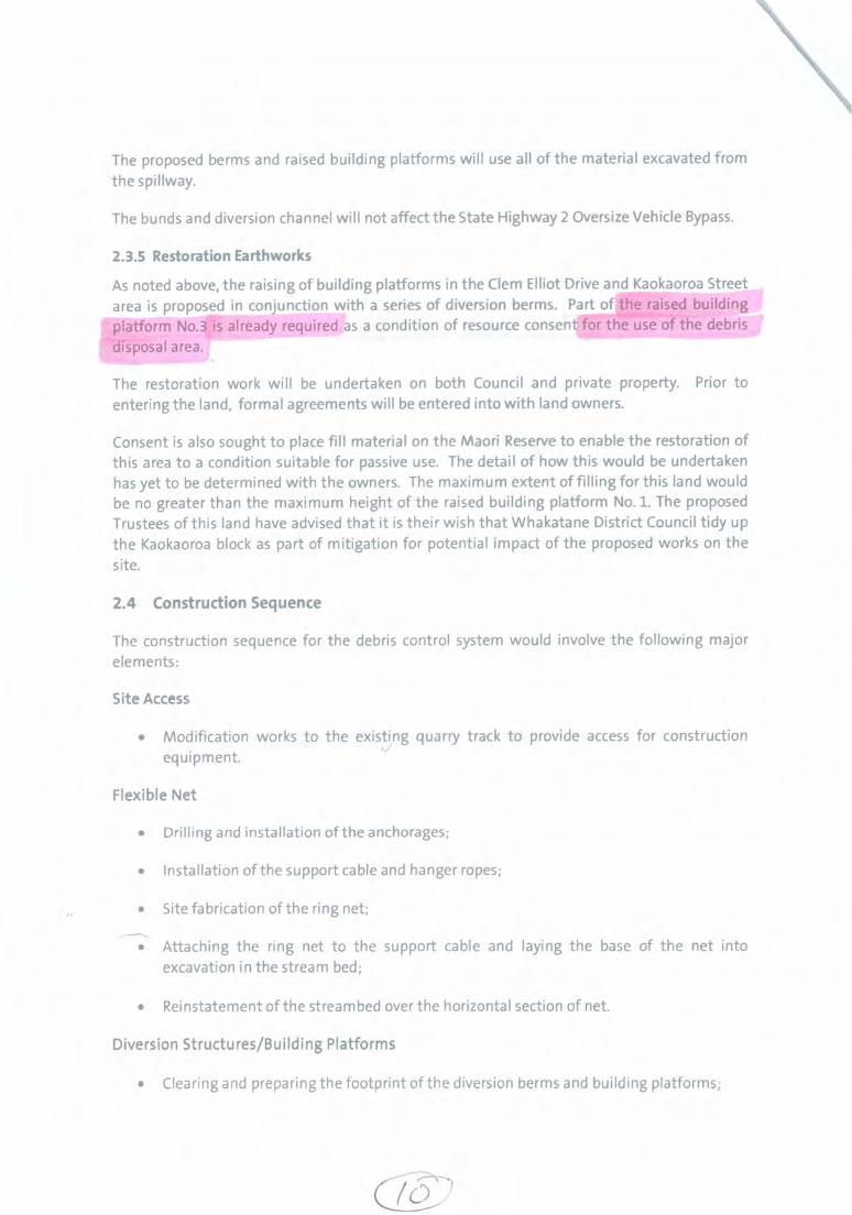
The proposed berms and raised building platforms will use all of the material excavated fromthe spillway.
The bunds and diversion channel will not affect the State Highway 2 Oversize Vehicle Bypass.
2.3.5 Restoration Earthworks
As noted above, the raising of building platforms in the Clem Elliot Drive and Kaokaoroa Streetarea is proposed in conjunction with a series of diversion berms. Part of the raised buildingplatform No.3 is already required as a condition of resource consent for the use of the debrisdisposal area.
The restoration work will be undertaken on both Council and private property. Prior toentering the land, formal agreements will be entered into with land owners.
Consent is also sought to place fill material on the Maori Reserve to enable the restoration ofthis area to a condition suitable for passive use. The detail of how this would be undertakenhas yet to be determined with the owners. The maximum extent of filling for this land wouldbe no greater than the maximum height of the raised building platform No. 1. The proposedTrustees of this land have advised that it is their wish that Whakatane District Council tidy upthe Kaokaoroa block as part of mitigation for potential impact of the proposed works on thesite.
2.4 Construction Sequence
The construction sequence for the debris control system would involve the following majorelements:
Site Access
• Modification works to the existing quarry track to provide access for constructionequipment.
Flexible Net
• Drilling and installation of the anchorages;
• Installation of the support cable and hanger ropes;
• Site fabrication of the ring net;
• Attaching the ring net to the support cable and laying the base of the net intoexcavation in the stream bed;
• Reinstatement of the stream bed over the horizontal section of net.
Diversion Structures/Building Platforms
• Clearing and preparing the footprint of the diversion berms and building platforms;
4−57

020/0/(4.−/777' 46−s4/E s 77154
lek/−vc−e−S s r A ) / 9 / k /filo
64.1? c−Divse"1−7− O R 1011:PEcTEo Exs−orjS.
A , 2 7 . E A 7 7 . P 9 − A i s E D i s 7 2 e , c i c − A f c / L 4sS ciAr−E C i T 7 1 3 , (.../ cif−r−/e),V "crot"
,_1114114 779−R I.9 7 * Lc/ 577eF−4714 .aez3veirS pe_01−‘) ^J77 SySrEfiei
1−4475 _f_s /1−NAziehrivr−−− _7v r i t e pz_pic . /y− ofA 4 0 0 / 771A1/9−(._ / − , ' n OF− f i z . 4._ 0 i v 77:70 o P 77/e.f /61 TD 8 E / 0 6 0−1−c i a (z1vVeee 7−−bie c o ,w9,770−FVi'.0 F
__777−e ,0 ez3ie is' 4 0 7 r a l o f t . c ermrs.e",−,−−− 7−0' ' 2 z_
OAT 7 rykrorxe−,16− g −7 C7V4_ 2 2 /"/Z9 3 Z C c−E0,316 − 4 C / 0 7 7 4 0 , e i c A : 7 7 4
/,e3,0e,"/5 /..Ny
J 1z / p a r r 77 , A i 0 tvz i Abiti.._ ' e t 16− 0 '31
f t 5 7 W e i f 9 9 AT 6 " i 77 v*.:
AfX/14.−E AfrApoiel‘to V794
.99 e 779/C−x
c ‘ p /ILO
S−0A,
445 czE
y .01^
(2/ve. a l T 7 7 cit:WOuVrwa
ieeD,V94. Cott−,Vc/C

tvE0A/Es411 y, 014−8c e−1 /&02/ *200.
1?−20 2 I
6.0 RISK
PUBLIC EXCLUDEDAdvice around the consideration of alternative solutions.
Funding CommitmentsCommitments and conditions for funding already received and work (infrastructure)undertaken by other stakeholders in the knowledge that Council was planning tocomplete debris flow mitigation works.
Financial ImplicationsAccurate costings and funding impact for the proposed DDS if it is to proceed;Implications for costs already incurred (and not able to be capitalised) if the proposedDOS does not proceed;Continued costs vs. the currently provision through the draft LIP and existingbudgets.
CommunicationsCommunications Plan to keep the public and those directly affected property ownersand stakeholders informed and to enable their concems/input to be received.
Council PlansImplications for the Councils LIP and District Plan if the DDS project was to change.
ResourcingThe establishment of a Project Control Group for the Debris Flow Mitigation worksand staff/consultant resource required to support a review.
ConsentingSome works planned were reliant on the consent for the construction of the DDS(such as earthworks in the Clem Elliott Road area). Other consents also assumed theconstruction of the DDS and may contain conditions that will not be appropriate if thestructure does not progress.
4.0 ASSESSMENT OF SIGNIFICANCE
This project was included in the 2009−2019 LTCCP due to its high significance. Adecision not to proceed in the future is likely to be a decision of significance; both interms of the financial implications and other criteria under the Policy for DeterminingSignificance.
The Council could continue working towards the completion of the DDS, by allowingthe consent to be granted and by continuing to work with engineers to enableapplication of a building consent. However given the risks highlighted by Tonkin andTaylor and CPG Ltd, this is not considered prudent.
The Council can request further information on the implications of a change to thecurrent Debris Flow Mitigation works project to enable future decisions on the futureof the project to be made. This will entail further reporting to Council on theimplications of a change to the current proposal.
7 − h . I A / c 7 I F 4Th−30E
c O l v s / ,−−−−71−fe.': .0,14,−,−1 , 4I / 0 A r t r r / 1 ) R, 0 ce iw.
A/ 2 0 I 2/ A i 4.4 ,.;− d e c − ,t73 3'1,e L:y 7 / 4 −
/ 36 N o .0/1−?,,k 8 v 7(Dc)
7z,
A273291
((SPAGE 3 OF 5

/ 3 c ‘ 20.2
PUBLIC EXCLUDEDBefore the Council can consider the future of the project it needs to understand theimplications of a change to the project. Staff will investigate those implications andreport back to the Projects and Services Committee so decisions can be maderegarding a future direction for Awatarariki Stream debris flow mitigations works.
RESOLUTION:
1. THAT the report "Matata Regeneration Awatarariki Stream − Debris FlowMitigation Works" be received; and
2. THAT the Council request that further information be provided on theimplications of a change to the Awatarariki Stream Debris Flow MitigationWorks (Debris Detention Structure) including
• Legal advice• Existing Funding Commitments• Financial Implications• Communications Plan• Implications for the L W and District Plan• Resourcing options• Project Control Group• Consent commitments
3, THAT the Council arrange a meeting of major stakeholders and directlyimpacted property owners to discuss a review of the Awatarariki Streamdetention project.
4. THAT following the meeting of major stakeholders and directly impactedproperty owners the Council release these resolutions to the public.
ChapmanING GENERAL MANAGER
INFRASTRUCTURE
Attached to this report: • Matata Debris Flow Mitigation Structure — Overview ReviewCPG Limited — March 2012
A273291 PAGE 5 OF 5

/SsLtEs, s E /7I q L k / 13/c4e6−7Rs'
irn o 6/ 777− S i T T , /−
1 9 C Y91−" 1 7 7 4 1 1 A 6 F / 0 , 0 s ) − 2 ? T T /
a−−(fic− 5„isic−4Ea #97− 7)5L74
if−,,/ v , A'. c . zkorp−, 10_,ro"−f−iv r9ive.E A.IEi i i a _ r /.3(„)/4. . 0 , A l 771−−−&− e7,97−2−.7 /4,,c',#e S 7− ? 713
.47125,, f ii_1.−lit6−frit' ' l e ?'...−−−'le 77E5 z9544e2 77,−− c_4.−rheac.,/o
−−D i t k 5 F i e a−k? AL−itro 4771W ,61−(irkm"A l r4., / 7−−
/ V & / / f i E S O z_, / 1 / 0 1 / z,a__E N4q−v41:7 / 4 z.6−4,,i− / A i ."57...−ti L n i 0
_e6ze:c7)ee− .47−− L._,−.4 3− r"− 0 , 4 , E 4/ ie .47r , t9 ,1 Et? 6 J t i o I._ i a C O
L A ! C 4, 6 − i En &e. i 0 7 7 zAee I c..−C_ /...−c•,?c 2, / y e,4,4:z s Q1,,e/cve
7 r yv i4y 2 0 o 3 ) j'A.95 RE7−−ei−ie/vso .7"v /−fre.rs / 7−,741−7−−−.*5::.escr;4' gh−/.1/5 t −−fl 0 77/kEif Ajoz..."7 A/E/9e−− .
,( e i d , C , − 1 . 5 < O D 4 v T / 2 /e−4−7−−−F__I /.9"40 ?2i .0 A/0 7"−−
'1−7 7−Evr .4..../ A<E•
/ s /a/4 4 , d e / 0 A5L−r,s− x, s . A /
1 c M /1 „14___V___ _ I %vw „eZ'cc:,/,/,−1/7 ,e2/S7x7/itaf,y7−−−− 0
Aitito 4 , e / 5 z − z i c ' − / 9 / / g / 1 4−007z,. − " /−−"e 7−−−/c e i 4777−zee e / 5 / v o 77e/ 4
,7−−4.A.._ y o z , , i 9 − 8 −0
f i cAC−7−−− /−3,745.−−−−− zi− 7"7/t/− 5 '17,40 4 1 , 4 − e s . c
7−7:67/14. /7−67,9ef fAif−s
E ' ti&X? xv− 7 − − C 7 /vr−i9 7 7 / 4 2 .77/45 / 5 Ai bit? ,v−i−v7 city eriv−c,/ 0,01/
2 3 R d A5.5 2 o / 2 7−Z7 C C777
/3/5) emetv D e r . 1 " s−~ ' co/v7vc7− ;LI− /91=1=6".l0/i5W 7? 6S /47 C **°*1 C 0 77− oare I ("E "9",,Z2 L 634 1//iti,
7 a "re− /Iiiiets.,e_S / A / cf9ts La−frxñ / v i e . 5 77,111 "51−71/67 ev−)51−S 0 A l s ,057−27
/ 0 i n 19/VC 77/ v 0 G o A/7"stc−7− rz)
111, 771̀eAI 1 4fr −− /"(−Ce. e s /9−−"/Z2,,E) CC 1−5ao /)−1).nreeidlit1
743) tp,o/fire /71 er e?"7
Itk.)

5 0 i r − 4 7 0 .67,5 / v− , −− //t−Lcbi._ 4 , ) / 7 4 . / / r e i s / 9 / 0,
/ 4 //
/ _ f e , i z ? 4 . i C , E x − c 4. ci . 0 E−6? /Q,901. , ie7−−− o F 4,cso
7 7 4 / / p − z o 2−• 2 −/ )
_1 /4 ,0 i4 i6c 7 7 , /5,−− ./.4' e c 7−4.0
0 A f E R A l e , f r y . , zr*,
g e − s e_
O C /1,v−7−Ece6:s',"" 7 7 i 7 s c e . . T r . .4,34−−rv/C e f − s s 7 − 1/−,9−e_jyfritir,q)N/
__7_7171/.f
/ p i g r y 771−is: i v s − E 3 4 e 9 v „−−//c
& / L L 7 1/e−et
/ 1 7 4 7 9 − 0 E 3 0 A r o f 7
R A : 5 A / , 5 7 ) 9 r e r o i L V / 9 − 5 − a e„) .arc4‹ 644 7__ /17.ve2_z < 2 c4 − 2 − 0 7 − c c w−? . 0 . 9 7 " . f i
c . , 0 , v e v , 0 3 " F/e−−4_,,,v/c / A / p m . 0 771−awf
M T ° O i v E s i C 7 −3−A./3" " I t r v o 64−eoci,e
5 7 − v " % Z . , 5 o c) 4 0 ‘ , e ) 1 E # 7 0 7 1 7 ‘ i i : / 1 " 7 / 4 _ t i l r g : _ , 5 1 ) T 0 e . .̂ / fra−tPr&− c C > I )0/−/−−,9 4.− "9−71/0 I c a r u e 67 c.„−4.−,07,4,‘40(A7−5
7 6 _ C o 4 1 C − 4 0 I T E r n * # 9 − W • S .E1497t!
44z_ 6.1_,94. 644../0,6−‘7 /74 0 0A/743
o
/ _ic."9"C s j s , 4 2 A , / A . 7 7 /
/C−1(f A l f 724•6we , f c, . 0 •−)13 4 . . 6 7 9 4 .
7−2,7if /.5 427− / 7 1 − v i / 0 9 7 V 7 − 1 9 4 _ O F S D 0 0113_,
/ 4−5 / 5 W 7isd.e2,6) )• i e v 0 o "c−79eZi w0
4pie t v−k* /97−v−P F45.7 6 / 7 ` p r i tv/ee−−
n i W . 5 E −m e −A i r − 7 w / 1 n / 19 C / * . C7t,
__/er5v−g 277,75: S i " 5 L 41−7−/c fri,7_s.
S E c in? (−7"/S S O 7−Me .4_ 4 y o e w / 1 − − 0 e , t 7 , 9 7 7
_•49 t.t) / ) ? ' v f e . 0 e 1 s i t e− c,L.J 4_09 e&−− I−−5
1 9 5 J r − 43− S 0.17−z−9^4, / 9 c.)4,kv7−. 0 1"−−.irer9−e,e' e l e " / , f ' & 7 7−0
/ r _ 0 / 4 7−− ./..."−kc,c_ 77−74−7E / 9 4 / 1 , 4 / 7 1 & J . , / .A...9fer−0"/
e c o w f S e 3 , 7 "ep9I 5 Z 7 1 9 4 A7 −e;49−40y,i
7 7 1 2 : i i e E ‘26−ew A−−−).−2L7dt,z' /1/−ovser7−0 704−v9171'2er 77−/−4F 7 diir
_ −−.−.−−−1 9
c v s : 5 − 7 4 . 1 / eru?%1 refre6:− / ) GO #74−/e
! 6 C I é 7 7 v E a . C o z , r ) v − F , S / 7 ? " )

e O S 105,0/5... e e , a 4 , ) • C /51.5,5 .61̀
V / L A eq− P eTh−ri A i ?"−−17'
of7−h−E That−e−e 44isAo 4129i
/ _ , s s
v−r− / 1 7 1 1 / v−v 4 . / 7 E 0 v i g o c
c_e„,−sr 19−77 #4−c,−, e E 71) /
__,/ 71− 4 5 2 7 Aq oi−s ge−e4c−−−/i y7−−−−/z4,−−"0−−− 77/),.._ 0,
2 0 0 3 4 4 / 7 1−0 4.5 E−4−it' A l l iehee 1.4..so
s E i−vesre.e?−, e 7 7 − " − 2 •bAi'r−
, /94−S*42 / A J *7−2−,−− . 8W−c−−−1< ,"9 −f r 6 7 . r #3,..%.
0 1 i l / 0_
rfriz ,??. .e oposs− / e c e 7 ,...5−−Ag−c− 7?4,−>af o F 4,04−−"P,
f r v i i S S / A i i i 1 = r Z ( . 3 ) − 1 − 1 . 1 C c#,32− ,,e#A4,61−/e/7−−
5 c 7−.E.,,0 " igecyzoe 7−7−fey
7 7− / / 1 c , e 4 F , 7 7 L./Pe iteic34,−,v7−−,−L/ gis .0451.7 7
‘ ‘ ) − 4 ,55 .61− A n f i r C r e ) or A " _7,0 5 − 0 t
A l f /9−"ft / 0 ,fre−.9f,? , 1 , 0 7 o#J rn
E7−ARI c P / 4 ,I at9 / V b%),OC: i,1,,a2 ie,"? 0446−ee r y "9−−ev29
/04−evi4−770
Ci ev−ti z e h− ( 1 , 1 e 4,%.1
−7− o7 2 / S−%7
0 2 / 1 4 4 , ? /
/6

738Whakatane District CouncilAwatarariki CatchmentDebris Control Project Review
Subrnitter's NameDavid Potter for NgatiRangitihi Raupatu Trust
Page 116
SubmissionSubmitting conceptual outline of direct channel to sea preparedby Joos Potter, Tangihia Consultants and Associates for NevilleHarris and others.
Section 5.3.3Comment in Report
Lee & Earl Schlichting Opposed to ring net and debris dam.Proposed upstream catchment work.Concern with restrictions on property.
Sections 1.3.5 to 1.3.10, 3.5.1, 5.2.3, 5.3.3 and 6.1.1Section 2.3.16Sections 4.5.1 to 4.5.5
Keith Sutton Concerned with impact of remediation costs on ratepayers anddelays.Concerned with breaches of resource consent conditions byWDC.Concern with restrictions on property.
Section 3.3.4 and 3.3.5
Not part of scope of review, WDC conducting audit of consentcompliance.Section 4.5.1 to 4.5.5
Pam and Bill Whalley Not in favour of debris dam.Concerns about risk from direct channel to sea.Frustrated with indecision and additional costs of rates andinsurance.
Sections 1.3.5 to 1.3.10Section 5.3.3Section 3.3.4 and elsewhere.
Issue No 5: Final18 June 2012
O i e r /̀ LI0/9− f z i OF / 4 ) p t , ' /1/,11x
Copyright © 2012 Alan Bickers, Jayal Enterprises Ltd
TO:
r i f e c − F i7C−4,14 rexd,ei—
C−Pediec,(9 24.2.06.195r0{75,) 24.02.07.158
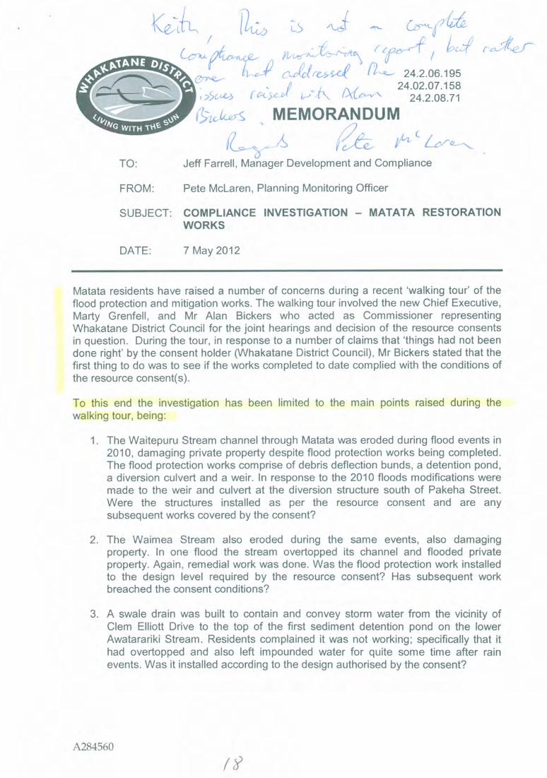
24.2.08.71&−icike,S MEMORANDUM
Jeff Farrell, Manager Development and Compliance
FROM: Pete McLaren, Planning Monitoring Officer
SUBJECT: COMPLIANCE INVESTIGATION — MATATA RESTORATIONWORKS
DATE: 7 May 2012
Matata residents have raised a number of concerns during a recent 'walking tour' of theflood protection and mitigation works. The walking tour involved the new Chief Executive,Marty Grenfell, and Mr Alan Bickers who acted as Commissioner representingWhakatane District Council for the joint hearings and decision of the resource consentsin question. During the tour, in response to a number of claims that 'things had not beendone right' by the consent holder (Whakatane District Council), Mr Bickers stated that thefirst thing to do was to see if the works completed to date complied with the conditions ofthe resource consent(s).
To this end the investigation has been limited to the main points raised during thewalking tour, being:
1. The Waitepuru Stream channel through Matata was eroded during flood events in2010, damaging private property despite flood protection works being completed.The flood protection works comprise of debris deflection bunds, a detention pond,a diversion culvert and a weir. In response to the 2010 floods modifications weremade to the weir and culvert at the diversion structure south of Pakeha Street.Were the structures installed as per the resource consent and are anysubsequent works covered by the consent?
2. The Waimea Stream also eroded during the same events, also damagingproperty. In one flood the stream overtopped its channel and flooded privateproperty. Again, remedial work was done. Was the flood protection work installedto the design level required by the resource consent? Has subsequent workbreached the consent conditions?
3. A swale drain was built to contain and convey storm water from the vicinity ofClem Elliott Drive to the top of the first sediment detention pond on the lowerAwatarariki Stream. Residents complained it was not working; specifically that ithad overtopped and also left impounded water for quite some time after rainevents. Was it installed according to the design authorised by the consent?
A284560

Each of these works was covered by separate resource consents issued by the Bay ofPlenty Regional Council and the Whakatane District Council. This investigation relatessolely to the Whakatane District Council conditions. It is noted that the joint hearingscommittee did a good job in ensuring each agency's consent conditions complementedthe others.
1 Waitepuru Stream works
The Whakatane District Council resource consent is 24.2.07.158 (also numberedLL2007−7676−00 as the file system changed at this time). The following extract from thedecision describes the purpose of the consent:
WHAKATANE DISTRICT COUNCIL
DECISION ONRESOURCE CONSENT APPLICATION 24.2.07.158
Pursuant to sections 104, 104B and 108 of the Resource Management Act 1991, theWhakatane District Council hereby grants consent to Whakatane District Council for theapplication for land use consent for earthworks in the Rural 1, Rural 3 and Rural 4 zones,comprising;
• Construction o f a debris and stream control structure at the point where theWaitepuru Stream exits from the adjacent escarpment;
• Controlled return o f the Waitepuru Stream to its pre−May 2005 Channelthrough the Matata Township, with associated channel improvement andprotection works and upgrading o f the culvert under Wilson Street;
• Conveying flows that exceed the capacity o f the town watercourse through anew culvert under the East Coast Main Trunk railway line (ECMT) and StateHighway 2 to a drain and overflow swale leading to the Awarua Drain andt he Tarawera River;
• Retrospect ive consent for a flood overflow culvert; and
• Realignment o f Manawahe Road over the proposed bunds o f the debriscontrol structure.
Much of the consent related to the construction period (mitigation of nuisance effects,mitigation of traffic hazards, notification of works requirements, etc). This compliancereview is limited to assessing conditions that provide outcome criteria, being anassessment of the works in place against the information referred to in Condition 1.1 andwhether recent changes to the structures still fulfil the design criteria defined in Condition4.11 (see text box below).
A284560

1. General
1.1 Unless otherwise modified by conditions o f consent, the Consent Holder shall ensure thatall activity undertaken under this consent shall be carried out in general accordance withthe application and all supporting information received by the Whakatane DistrictCouncil (WDC) and held on WDC file 2330/0005/000 including;
(i) "Waitepuru Debris and Stream Management WorksAwarua Drain Stop Banks.Resource Consent Applications".Boffa Miskell (September 2007).
(ii) "Waitepuru Debris and Stream Management WorksAwarua Drain Stop BanksAlterations to Proposals and Further Information".Boffa Miskell (February 2008).
• • •
4.11 The works shall be designed in general accordance with the application and the followingdesign criteria:
(i) diversion o f a debris flow event up to the size o f the 18 May 2005 event.
(ii) Management o f a 100 year return period flood event (peak flow 13.5 cubic metresper second), with a design flow o f 8.9 cubic metres per second to be diverted to thetown watercourse.
(iii) Earthworks are to support the achievement o f the design objectives o f (i) and (ii).
(iv) The earthworks shall also provide for:
• A global stability factor o f safety greater than 1.5 for normal conditions andgreater than 1.2 for extreme conditions. Factors o f safety for steep innerbund faces may be locally less than these values.
• The bund is to remain intact after a 475 year return period earthquake withbund crest deformations no greater than 0.2m.
• The bund elevation is to allow for construction and post earthquakesettlements so as to maintain a minimum freeboard to achieve (i) above.
• Erosion protection o f channels is to provide for a flood event o f at least oncein 100 years probability.
• The final shape o f the debris control structure bunds shall whereverpracticable provide a natural contour consistent with the adjacent foothilland escarpment landform.
• The maximum slope gradient o f the external bund faces shall be no steeperthan 1:2.5 (vertical: horizontal), and wherever practicable 1:3, to ensure thatproposed planting can establish without the need for slope stabilisationtechniques.
A284560
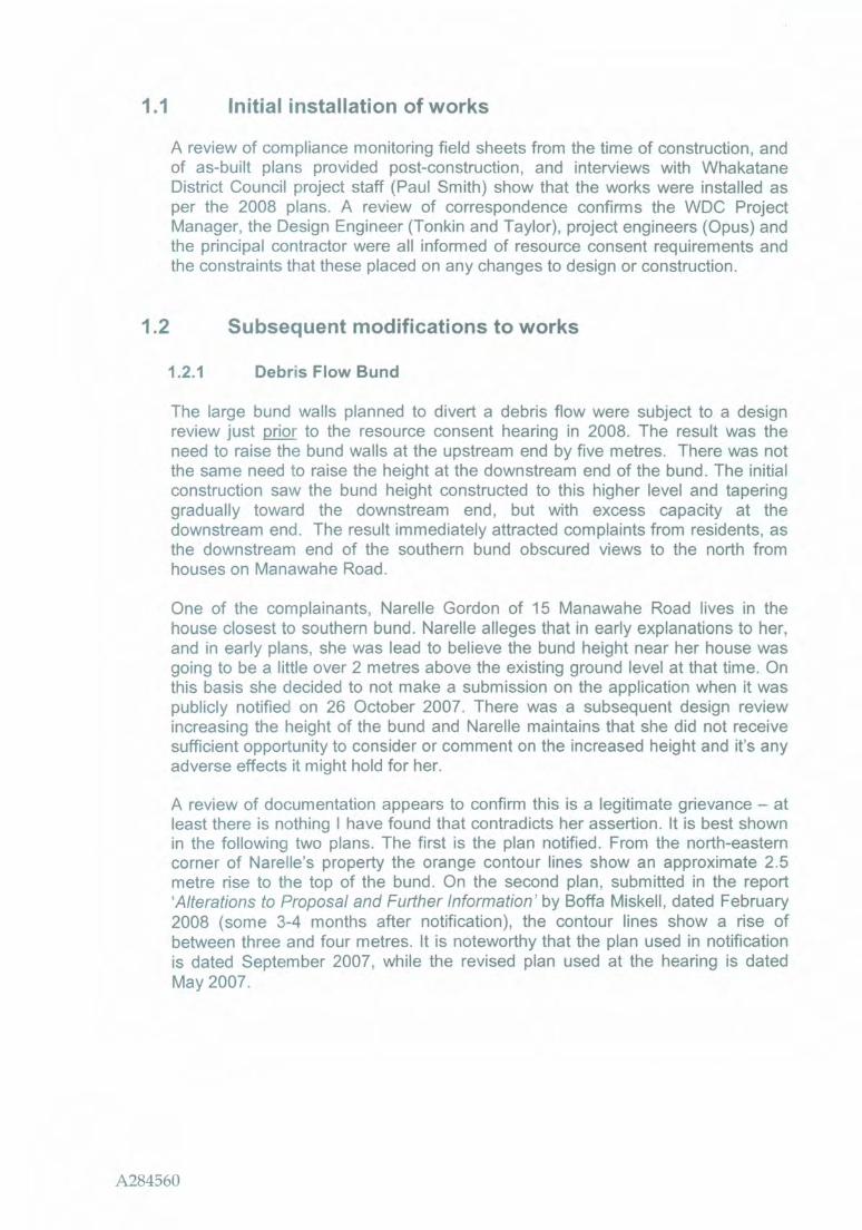
1.1 Initial installation of works
A review of compliance monitoring field sheets from the time of construction, andof as−built plans provided post−construction, and interviews with WhakataneDistrict Council project staff (Paul Smith) show that the works were installed asper the 2008 plans. A review of correspondence confirms the WDC ProjectManager, the Design Engineer (Tonkin and Taylor), project engineers (Opus) andthe principal contractor were all informed of resource consent requirements andthe constraints that these placed on any changes to design or construction.
1.2 Subsequent modifications to works
1.2.1 Debris Flow Bund
The large bund walls planned to divert a debris flow were subject to a designreview just prior_ to the resource consent hearing in 2008. The result was theneed to raise the bund walls at the upstream end by five metres. There was notthe same need to raise the height at the downstream end of the bund. The initialconstruction saw the bund height constructed to this higher level and taperinggradually toward the downstream end, but with excess capacity at thedownstream end. The result immediately attracted complaints from residents, asthe downstream end of the southern bund obscured views to the north fromhouses on Manawahe Road.
One of the complainants, Narelle Gordon of 15 Manawahe Road lives in thehouse closest to southern bund. Narelle alleges that in early explanations to her,and in early plans, she was lead to believe the bund height near her house wasgoing to be a little over 2 metres above the existing ground level at that time. Onthis basis she decided to not make a submission on the application when it waspublicly notified on 26 October 2007. There was a subsequent design reviewincreasing the height of the bund and Narelle maintains that she did not receivesufficient opportunity to consider or comment on the increased height and it's anyadverse effects it might hold for her.
A review of documentation appears to confirm this is a legitimate grievance — atleast there is nothing I have found that contradicts her assertion. It is best shownin the following two plans. The first is the plan notified. From the north−easterncorner of Narelle's property the orange contour lines show an approximate 2.5metre rise to the top of the bund. On the second plan, submitted in the report'Alterations to Proposal and Further Information' by Boffa Miskell, dated February2008 (some 3−4 months after notification), the contour lines show a rise ofbetween three and four metres. It is noteworthy that the plan used in notificationis dated September 2007, while the revised plan used at the hearing is datedMay 2007.
A284560

Figure 1: The design plan for the Waitepuru Stream bunds as notified.
A284560

4
i t . 1 P e a i d S C O E : ( imozitais t o t 1.4,71−015.1q9Z. ,101.530 CW,MAA.1.1.44.;WOIS..5.11,L9t6,
Figure 2: The design plan for the Waitepuru Stream bunds altered afternotification and before the hearing.
A284560

In the documentation submitted altering the application, the applicant's consultantstates in relation to affected parties "Subject to mitigation as suggested thealteration will not be noticeable". Narelle Gordon disagrees and as the differencein height approaches an extra 50% at this point, I agree with her.
There is documentation on file discussing the need to re−notify the application. Inthe end it was decided that re−notification was not necessary as long as partiesdeemed to be affected by the change gave their approval. Theses parties weredeemed to be: V & F Muller, H & G Burt, Transit NZ, and On Track.
WDC project staff maintain that Narelle Gordon was briefed about the changesbut being so affected by the change it is reasonable for her to have expected tohave been given another opportunity to make a submission if she so desired.There is no discussion on file as to why she was overlooked other than thecomment given above and the comment that the alterations would not extend thefootprint of the works on to any other property than originally planned.
After some negotiation a mitigation plan was arrived at to meet the concerns ofthe residents on Manawahe Road. Both the point at which Manawahe Roadcrosses the bund and the top of the bund downstream from there were lowered toafford the residents a view. I have sighted correspondence between the designengineers (Tonkin and Taylor) and the Whakatane District Council ProjectManager that confirms the lowering did not compromise the initial design criteriato "divert a debris flow event up to the size of the 18 May 2005 event'. In otherwords there was some overdesign initially that allowed a lowering to benegotiated with residents and still meet the resource consent condition.
Image 1: The southern debris bund showing the notch cut where ManawaheRoad crosses it.
There is no doubt that the initial higher protection afforded by the overdesign hasbeen reduced, but this seems to be a trade−off for views the residents werewilling to make. I note that one of the residents (closest to the southern bund) hasconsistently requested the bund be lowered further, even though her house ismost at risk from a debris flow but this has not been agreed to by the WhakataneDistrict Council Project Manager specifically because it would not meet thedesign criteria and would therefore breach resource consent conditions.
The slope on the bund faces meets consent conditions and I note that theplantings have successfully established and are being maintained as per thelandscape plan. However, some of the species chosen will grow 3−4 metres inheight over the next four years and could obstruct the light plane on to NarellleGordon's property. I recommend the species composition on the upper part of
A284560

the southern bund be reviewed as soon as possible in case changes arerequired.
In summary, the debris flow bunds were installed as per the granted consent.Subsequent modifications still meet the design criteria of the consent and I do notbelieve there has been any breach in compliance. However, there does appear tohave been procedural inadequacy between the time of public notification and thehearing that lead to at least one person not being adequately informed andtherefore not able to fully participate in formal consultation as prescribed by theResource Management Act.
1.2.2 Diversion culvert and weir, railway and road culverts andWaitepuru Stream Channel Works
After the 2010 floods widened the Waitepuru Stream bed through Matata it wasestimated that the stream had carried more water than the 8.9 m3/s designed topass through the culvert exiting the detention pond. An initial response was tobolt a steel plate over part of the inflow side of the culvert to substantially neckdown the flow. This is still in place and has served as a temporary protectivemeasure whilst the design calculations were checked to see why extra flow hadgone through the town. These checks showed a combination of too much headon the culvert and too little flow retardation due to friction and turbulence throughthe culvert had caused the excess flows.
The following summary is extracted from a letter to the WDC Project Managerfrom Tonkin and Taylor.
"The basis for the consented design for the Waitepuru streammanagement works, as incorporated with the debris flowmitigation measures, is that
"... all flows up to the 5 year event (7.7 m/s) will be directed toand conveyed in the town watercourse. A t the 5 year level waterwill begin to spill across the diversion bund and these flows willbe conveyed away from the town through the new ManawaheRoad, railway and State Highway culverts. In the 100 year wateronly event the flow split would be approximately 8.9 m3/s to thet own watercourse and 4.6 m3/s to the Awarua Drain system tothe east of the town. ... a flow of 8.9 in 3/s corresponds toapproximately a 9 year return period peak flow from thecatchment through the town watercourse at the time of the 100year return period event in the catchment." (ref. T BassettEvidence to the Environment Court, July 2009).
Preliminary design o f the diversion, stream and culvert works tosupport the resource consent application was carried out by T&T,with detailed design by Opus International. Construction of theworks„ supervised by WDC, was completed in May 2010. Worksalong the Awarua overflow bypass route were designed andcompleted by the Bay of Plenty Regional Council.
Since then, from observations made and analysis following highruno f f from the catchment, i t is apparent that more flow is beingconveyed to the town watercourse than intended. The diversionweir upstream of Manawahe Road is too high, and the 2 m by 2mdiversion culvert is too "eff icient" meaning overf low to the Awarua
A284560

bypass does not commence soon enough.
Heavy rainfall in May and June 2010 led to significant flows downthe town watercourse, wi th flooding o f a garage in Heale Street,and erosion o f the new channel between Pakeha and WilsonStreets. I t is estimated that the peak flow in the town
watercourse may have been as high as 12 rn3/s."
Culvert to townNormai4
11,
rivitior op t
Debris flow blind
iversion weir
Culvert loAwarua drain
,
Image 2: The design intent of the Waitepuru diversion system
Image 3 : The culvert under the debris bund discharging to theWaitepuru watercourse that flows through the town − lookingupstream to the temporary choke plate.
A284560
2
The solution was to lower the weir height by approximately 900mm over a portionof its length to reduce head at the culvert. Modifying the culvert to increasefriction was also discussed, but this has not been done yet.
As the culvert and weir work together to simply divide flood flows two ways, areduction of the weir height must increase the number of times the Awarua flooddiversion channel is active. The question is "Is this in line with consentconditions?" I am satisfied that it is.
The system is designed on the basis of a flood flow of 8.9 m3/s being the target inthe Waitepuru Stream channel through the town. All other flows are to go overthe weir. The works lowering the weir and restricting the culvert are simply finetuning to achieve the consented design. It was unfortunate that damaging flowsoccurred through town, but I am satisfied that the corrective action at the culvertand the weir was to meet the intention of the resource consent and was permittedby the consent conditions.
Repairs to the stream channel itself and the various structures therein weresimply to repair damage and to reinstate the level of ongoing protectionenvisaged by the original design (i.e. to cope with 8.9 m3/s) and do not representan increase or extension to that design.
1.2.3 Awarua flood diversion channel and Awarua Drain works.
The overall design calls for the management of a peak flood flow of 13.5 m3/s with8.9 m3/s going down the Waitepuru and the balance (4.6 m3/s) going down theAwarua flood bypass. Works have been installed as per the original design. Thelowering of the weir should not impact on this design as it was to simply apportionthe correct design flow down the Waitepuru Stream. That being the case, thebalance flows to the diversion channel and down the Awarua drain as originallyintended.
2 Waimea Stream works
The Whakatane District Council resource consent is 24.2.08.71. The stream runsthrough many private properties and the location of remedial work was specified in theintroduction to Condition 1 of the consent. The broad outline of works is detailed inCondition 1(a) by reference to the reports supplied with the application. These conditionsare provided in the text box below.
A284560

O n 4 Augus t 2008, the Commissioner Russell De Luca, under delegated authority,resolved as follows:
THAT pursuant to Sections 34A, 104 and 108 of the Resource ManagementAct 1991, and Rule 4.8 o f the Proposed VVhakatane District Plan, theVVhakatane District Council grants consent as a discretionary activity toundertake Waimea Stream management works on land as follows:
Site address: 26,28,30 Pakeha St; 29,31,39 Wilson St;12,14,16 Division St; 3,6 Clarke St;4,6 Grace St; 61,63 Arawa St.East Coast Railway, State Highway 2, Division St,Clarke St, Arawa St, DOC Reserve (Matata Lagoon).
Legal Description of Allotments 104,112,185,194,195,244,250,372 Town ofSite: Richmond;
Lots 1,2 DPS 14501; Lot 2 DPS 14394;Lot 1 DPS 20449; Lots 1,2,3 DPS 23643.East Coast Railway, State Highway 2, Division St,Clarke St, Arawa St,Section 1 Block 1 Awaateatua Survey District(Recreation Reserve − DOC).
subject to the following conditions:
(a) The proposed activity shall be carried out in general accordance with theapplication numbered T06059 titled "Matata Regeneration Works, Waimea StreamManagement Works" dated April 2008 prepared by Boffa Miskell Limited and all
I have reviewed the plans referred to in 1 (a), inspected the works completed, andinterviewed Council's supervising engineer, Paul Smith. With the exception of the culvertunder Pakeha Street, the works specified in the consent have been completed as per theplans. Minor changes were made during construction but these were inconsequentialand would not have decreased the performance of the works or beyond the scope of theconsent (for example, installing a new culvert as per the design, but adding a small wingwall to match the existing culvert that remained in place).
Post−installation surveys have established the large culvert under Pakeha Street,installed by the NZTA, has been set slightly too low. The effect of this is to throttle theflow slightly. It is very unlikely that this has any bearing on the overflows from the streamchannel downstream of Pakeha Street. However, if the flow has been throttled (say by abuild up of bottom sediment) it might cause unintended overtopping of the streamchannel upstream of the culvert which then could result in uncontrolled surface waterflows outside of the stream channel.
A284560

Image 4: The Waimea Stream culvert under Pakeha Street showing some silt build up −evidence the culvert has been set a little low.
In 2011 after the works had been completed, a flood in the Waimea Stream saw thechannel erode (deepening and widening it) and at least one instance of the streamleaving its channel. The main overflow occurred immediately downstream of PakehaStreet. This has been the subject of complaints. In response to this flood, furtherremedial work to the stream channel has been carried out. This work was not done underresource consent 24.2.08.71 and did not affect any of the works installed under thisresource consent. The works installed under 24.2.08.71 coped well with the flood and,with the exception of the overflow; the damage was done in sections of the stream notsubject to work under this consent. In terms of assessing compliance with 24.2.08.71 theadditional works must be seen as additional to and separate from works authorised by24.2.08.71 (in fact they were installed at a later date).
The overflow immediately downstream of Pakeha Street was in a section of the streamsubject to works under this consent. The works were installed as per the approved plans.The conclusion must be that either the flows were greater than those designed for, orthat the design authorised and constructed was inadequate to contain the target floodflow. In the case of the former, compliance with the resource consent conditions is notaffected; and in the case of the latter the works still comply with the consent but do notfulfil the purpose for which the resource consent was obtained. There is no stream flowrecording data available to clarify this point.
In summary however, it is possible to state the overflows from, and erosion in, theWaimea Stream channel that are the subject of complaint are not caused by non−compliance with the conditions of resource consent 24.2.08.71.
A284560

The drainage swale at Clem Elliott Drive referred to is to provide drainage of excesssurface water. As such it has to provide means to collect, contain, and convey that waterto the primary sediment basin. The swale was installed as per the design plans. Thefloods of 2010 and 2011 showed that the discharge point of the drain was subject tosediment build−up in the primary sediment basin. Essentially the flow of the AwatararikiStream undergoes a sudden drop in velocity near this point and suspended sedimentdrops out of the water column at a rate and quantity that is not able to be moved bywater flowing down the drainage swale. In effect the sediment carried by the Awatararikidams the bottom of the drainage swale.
The effect was that the water in the swale was unable to get away and ponded behindthe sediment dam. It is doubtful if the sediment impeded the efficiency of the swale tocapture and contain surface water when the Awatarariki Stream was in flood as the lowerswale is subject to the backup of water in flood events in any case. However highintensity rainfall of short duration flowing from Clem Elliott Drive into the swale may nothave drained efficiently from the swale because of the sediment dam; and theimpounded water itself presented a hazard.
The fix has been to raise the bottom of the swale so that an even gradient exists from thetop end of the channel to the approximate level of the sediment build−up. This ensuresthe water does not pond. Capacity in the drain has reduced compared to the plansauthorised by the consent. However, the intent of the swale was to collect, contain andconvey water, not to store it. The changes can be viewed as fine−tuning to achieve theaims of the swale as outlined in the consent and to remove a water hazard that wasinadvertently created.
I do not believe the problems experienced by the residents were caused by non−compliance (i.e. building a swale to a design other than that authorised), nor do I believethe subsequent changes are of a magnitude that require formal variation to theconditions of the consent. The consent holder will be asked to furnish the modified as−built plans along with an explanation of why the changes were made.
Pete McLarenPLANNING MONITORING OFFICER
A284560

3 Western Swale (Clem Elliot Drive)
The Whakatane District Council resource consent is 24.2.06.195 (also numberedLL2006−76662−00). The decision was appealed to the Environment Court. The followingextract from the Environment Court's decision describes the purpose of the consent:
Decision
Pursuant to sections 104, 1048 and 108 of the ResourceManagement Act 1991, the Whakatane District Council grantsconsent to Whakatane District Council for the application for landuse consent for earthworks, vegetation disturbance and sitedisturbance in the Rural 3, Rural 4 and Natural Hazard Zones, theArea Sensitive to Coastal Hazard, a riparian margin, and a scheduledNatural Heritage Feature, comprising;
• Excavation and deposition earthworks within the WesternMatata Lagoon (Awa o to Atua Lagoon) involving reshaping ofthe lagoon to provide for sediment retention basins, openwater, terrestrial habitat and wetland habitat,
• Excavation of the bed of the Awataratiki Stream andassociated earthworks to increase the channel capacity,
• Armouring the banks of the Awatarariki Stream to preventerosion,
• Earthworks associated with the excavation and removal ofsediments and debris from the Clem Elliot Drive m o o r * tothe extent provided In Condition 2.2 of this consent.
• Construction of a drainage swaie at Clem M o t Drive toprovide drainage from low−lying areas Into the Western MatataLagoon,
• On−going earthworks associated with the maintenance of theAwatarariki Stream drainage channels, removal of sedimentfrom sediment basins in the Western Matata Lagoon andwetland enhancement work,
• Authorisation for emergency works undertaken to carry outearthworks and channel clearing operations associated withthe clearing up of flood debris following the severe storm anddebris flow event at Matata on 18 May 2005.
Consent is granted subject to the Conditions set out below.
j a OF 7Nrhe term of the Consent shall be 35 years.,to a• *
.11t ' 2 t . i / 45'
ati
A284560

Your RetOur Ref: C2012 0586 & 64647
14 May 2012
ilralligo.m.Bay of Plenty
111401NO°"41" REGIONAL COUNCIL
Telephone: 0800 884 880Facsimile: 0800 884 882Email: [email protected]
Mr Keith Sutton Website: www.boprc.govt.nz
R 0 2 Paution Hotline: 0800 884 883
Waihi 3682 International: +647 922 3390
Dear Mr Sutton
Placement of excavated material from the Matata Lagoon
This letter is a follow up from our conversation on Friday 11 May 2012 with regard to thedeposition of excavated material from the Matata Lagoon onto the south side of the FarWestern Lagobn at the western end of McPherson Street, Matata.
A site inspection was conducted by myself, my colleague Wiki Mooney and Paul Smith fromVVhakatane District Council on 10 May 2012, to discuss the activity.
The site where material had been deposited has an existing resource consent 64647 issued forlarge scale earthworks in the area defined as the Far Western Lagoon (Railway Lagoon), whichhas not yet been exercised. The material was deposited at a previously used dump site alongthe southern boundary of the lagoon. At the site meeting we recommended that the exposedarea should be revegetated as soon as possible. Once the exposed slopes are vegetated wehave asked that the bund along the base of the slope is relocated closer to the toe to allow thepotential ephemeral flow path behind it to be kept open.
I wish to confirm that the deposition of the material complies with Rule 1 of the Bay of PlentyRegional Water and Land Plan. The Rule states that it is a permitted activity to undertakeearthworks of < 5000m3 and < 1.0 hectare of exposed area at this site within any 12 monthperiod. 1 am satisfied that the activity complies with the Rule.
I have sought advice from our lawyer to confirm whether or not the deposition of the materialrequires the resource consent to be exercised. His reply is as follows:
Under the Resource Management Act (RMA) Section 9(2) No person may use the land in amanner that contravenes a regional rule.. ... therefore it is permitted activity and there is no needto exercise the consent as the Rule is not contravened in this case.
If Whakatane District Council were to place any additional fill on that site before May 2013 theywould contravene the Rule and thus would be in breach of s9(2) unless they exercised theconsent. The following would then apply: s9(2)(a) No person may use the land in a manner thatcontravenes a regional rule unless the use is expressly allowed by a resource consent.
Bay of Plenty Regional Council −1' n o \ 161 Whokatano

Placement of excavated material from the Matata Lagoon2
In addition, I have notified Whakatane District Council in writing that they must not deposit anyfurther fill at that site within 12 months without exercising the consent.
If you require any further information please don't hesitate to contact me.
Yours faithfully
Jessica Hunter−SmithPollution Prevention Officer
for Group Manager Water Management
A1348560

r a i l w a y lagoonS i n c e May 2012 c o u n c i l have n o t p l a c e d any more f i l l i n t h e r a i l w a y lagoon
a r e a , even though t h e y had a need t o c l e a n o u t t h e s i l t ponds t h a t resourcec o n s e n t 64647 c o v e r s t h e y t r u c k e d t h e Koiwi l a d e n s i l t o f s i t e t o Whakatanewhich i f e e l i s v e r y i n s e n s i t i v e t o l o c a l Matata i w i , t h e environment courtsunders tand ing was i t would remain l o c a l , d e p o s i t e d i n t h e r a i l w a y lagoon with
any remains found p l a c e d i n t h e s e t a s i d e reserve.

Draft Awatarariki Fanhead StrategyRisk Assessment
Issues and Options ReportConsultation Meeting
Matata Tennis Club, Matata
21 January 2014
Name: Keith Sutton
Property Address: 26/28 Clem Elliott Drive
Postal Address: TBA
Meeting With: Craig Batchelar
Meeting Time: 3.00 pm
Mr Sutton felt that the entire area in the Clem Elliott Drive vicinity was in effect a "red zone" as aresult of the Environment Court's decision to not allow any restoration or earthworks to be carriedout in the area. He considers that the Council's hands are tied by this decision which in his vieworiginates from central government and therefore requires central government intervention toresolve.
Mr Sutton is concerned that all of the options assume that there is the ability to undertakerestoration earthworks to some degree. He feels that it is very important that the legal basis forundertaking these works is properly addressed before any further decisions are made.
Mr Sutton feels that much of the content in the risk assessment undertaken by Tonkin & Taylor isbased on conjecture. He questions the conclusions on the return period for debris flow events ofthis magnitude. Evidence for this is that any debris flow within the last 100— 200 years would haveaffected the course of the river that used to pass to the west along the coast to its mouth in thevicinity of Murphys Motor Camp. In his view, the risk assessment is an overstatement and the risksare actually minimal.
Mr Sutton referred to the resource consents that the Council holds for the deposition of debrismaterial to the far western lagoon. He noted that this consent is likely to lapse in 2013 given that ithas not been legally implemented. He referred to 4,800 cubic metres of material dumped in the farwestern lagoon and that Council had asserted it had undertaken this work as a permitted activity.Mr Sutton considered that the Council was not correct in its interpretation and that as a result of thedumping there were now obligations for Council to comply with the conditions of consent for thedeposition area. These conditions include a requirement to raise building platforms on the landowned by his mother, Nola Neil.
Meeting_Note_K_Sutton_20140121.do&

Mr Sutton noted that part of his mother's site was restricted for development by coastal hazardlines.
Mr Sutton noted that he was advised by Council that there may be a connection to the proposed
sewerage reticulation.
The suggestion made by Mr Bruce Stewart to use the debris material to raise building platforms inClem Elliott Drive on his and Nola Neil's site was discussed. Mr Sutton was not opposed to this ideabut reiterated concerns around the legality of undertaking restoration earthworks given theEnvironment Court decision. He confirmed earlier comments that Council needed to carefully checkits ability to gain consent in the context of this decision.
Mr Sutton advised that his mother had become increasingly concerned about the lack of progress inresolving issues for the site given her advancing years. Mrs Neil was anxious about the lack ofresolution of issues affecting her property. In this context, their preferred option would be for landto be purchased.
Meeting_Note_K_Sutton_20140121.docx2,1

Page 1 of
Rh olite Farm
From: "Rhyolite Farm" <rhyolitefarm©gmail_com>To: <info©boprc.govt.nz>Sent: Wednesday, 13 December 2017 9:58 am.Subject: state of resouce consents Matata lagoon,Awatarariki fanheadgood morning , this is a request for information regarding two resourse consents held buy the VVhakatane district council, numbers−64474 and 64647 , one of which has direct effect on family property in Clem Elliott drive Matata could council please advise whetherthese are still running or have lapsed/expired and if so for how long?if they should need renewing are there more hearings and do the parties affected in the conditions get notification , and if being renewedcan changes be made to conditions that have become more relevant after the passing of 10 yearsAll information about these consents will be gratefully received,
yous faithfully, Keith Sutton
8/09/2018

Page 1 of 1
Rh olite Farm
From: "Rhyolite Farm" <rhyolitefarm©gmail.com>To: <info©boprc.govt.nz>Sent: Friday, 9 February 2018 12:41 p.m.Subject: QUERY of R/CsGood afternoon , back in Dec 2017 i made a query regarding two R/Cs taken out by the Whakatane District Council and got an automaticreply saying received ,then what is meant to happen?
Regards, Keith Sutton
8/09/2018

A/0 o: 5− _2444 /1/0−..vc 2(Do„Oz. c As/ OA/iNc z7e−o 5 s 51 /
[10] Numerous battles were fought in the area contesting the gateway to the Rangitaiki
Plains and we were told that many o f the ancestral chiefs o f Rangitihi had either died of
their wounds in battle or gone to die in the dune swales on the foreshore o f the harbour onthe seaward side o f Te Awa o te Atua.
[11] In addition the area was o f considerable cultural importance for several reasons:
(a) We understand that Ngati Rangitihi and other iwi recognised the domaino f taniwha on the landward side o f the Te Awa o te Atua outlet for severalkilometres along the river's length which imposed certain constraints uponthe type o f activities that could be conducted there.
(b) A number o f significant battles between hvi were fought in this area, the
most significant being a battle in 1863 or 1864 involving some 700warriors including from Ngati Awa, and Ngati Rangitihi. The battle, weunderstand, raged in the area around the western side o f the outlet to TeAwa o te Atua (Clem Elliott Drive area) and eventually warriors weredriven upstream into the Awatararild catchment with significant loss oflife. This has made the area, (now known as the quarry area), o f notableimportance with respect to koiwi o f Ngati Awa, and Ngati Rangitihi.
[12] In 1917 the Tarawera River was redirected through a cut o f some 5km to the easto f Matata and, since that time, the reach between the cut and Matata has becomeincreasingly silted up. Until the 1950s the area was still open to the tidal influence andthe effluent from the upstream industrial activities ponded in the lagoon area before thevillage and led to considerable concern. Eventually flapgates were installed and sincethen the water areas have re−established as lagoons.
[13] A 1939 debris flow down the Awatarariki catchment bought down koiwi, not onlythose o f Ngati Rangitibi but also koiwi o f other warriors in the major battles that havebeen fought in the area. Those koiwi were spread in the Clem Elliott Drive areaparticularly. The 2005 major debris flow brought down a much more significant flowand covered a far wider area. Nevertheless it is accepted that the debris includes koiwi ofNgati Rangitihi, Ngati Awa and Ngati Porou. Although not explicit, it appears thatTuwheratoa may also have koiwi in the area brought down by these debris flows.
Csa−D

13
Te .A.wa o te Atua Proposals
[36] The proposed Awatararild stream works and the lagoon restoration works have
been integrated so as to improve flow capacity through the stream system and provide
increased flood protection. The use o f floodbays to exclude flood flows and sediment
from the lagoon are intended to facilitate the restoration and sustainability o f the lagoon
habitat.
[37) Flood Bay 1 is designed essentially to slow water down and provide an area for
silt deposition to occur. It will need to be regularly maintained and Council estimates
that it may have a life expectancy o f up to 35 years with the removal o f silt o f around
100,000m3 which is to be disposed o f in the Railway lagoon area. Of course the length of
time until the 100,000m3 silt is deposited and removed is entirely dependent on the type
o f flood events which occur and the amounts o f silts deposited in Flood Bay Area 1.
[38] The engineers were not able to give us an exact silt capacity o f the Flood Bay I
area but we understood it to be something in the vicinity o f 20,000−30,000m3. There is
also some capacity through the additional flood bays for silt deposition although only in
the most major flood events would silt be deposited in the additional flood bays.
[39) In certain flow events, the flood bays would become full o f water and, in most
extreme scenarios, the floodwaters would overflow the central causeway to the eastern
lagoon areas. In lower flows, the stream would be directed through Flood Bay I to Flood
Bay 2 and thence into the restored lagoon areas. Water would flow through the restored
lagoon areas into Flood Bay 5 and, thence, through the causeway culvert to the eastern
Matata lagoons.
[40] The restored lagoons would be on the landward side o f the Te Awa o te Atua
lagoon where Council essentially seeks to recreate some open and shallow water areas by
excavation. Further consideration by landscape architects and ecologists has led to anapproach which would create varying water depths, enabling different indigenous plant
species to be re−established in the area and, hopefully, re−establishing wildlife,
particularly bird life, back into this area. A hope is that the depth o f up to 2m o f water
would be able to be maintained by using the flood bay to avoid the siltation which has
reviously occurred. Although the lagoons are a relatively small area compared with theb\l− OP pi,
cloc (sp)

36
preferable to reach appropriate accommodation to fill the Reserve Board land. It is
nearly inevitable that any increase in the land height by using fill would significantly
increase the usable area for the camp ground and enable the Board to consider anextension o f the facilities on the site.
[139] In the end we have concluded that we should not assume that the Reserve Board
will necessarily grant permission but note that the Council will not be able to implement
the rehabilitation and flood bay aspects o f the consents without such permission. If
necessary they may be able to vary their consent to enable them to utilise the fill
elsewhere (ie bunding around the camp ground) i f they are not able to obtain consent.
[1401 The Council considered they had reasonable prospects of gaining approval.
Subsequent to the hearing, Mr Patterson as Chairman of the Reserve Board filed amemorandum advising that the Board by the casting vote of the Chairman (Mr Patterson)
has rejected the Council's application to deposit fill. We note that DOC have givengeneral approval and have control of the camp ground land (though delegated to theboard). Although we cannot conclude that consent could not be obtained it would havebeen wise to ensure these approval prior to hearing rather than relying on further stepswhich may alter or delay the commencement of works.
Maintenance
[141] It follows from our discussion that we consider that the maintenance of the flood
bays and the other maintenance of the stream's lagoon works involved in these consentsis generally appropriate and the best practicable option_ Control of weed species andremoval of silts serves hazard mitigation and amenity functions. In our view the use of
the silt in the Railway Lagoon area will enable a proper completion of the debris fill areasand enable the rehabilitation to a much more natural contour and vegetation over coming
years.
[1421 The full benefit effect of the hazard mitigation will not be realised unless the areais maintained. To this end ow view is that suitable access would need to be maintained
so that the excavators and trucks could readily have access to Flood Bay I to remove silts
and to enable ready transportation to the Railway Lagoon debris fill area.. That of coursefollows as the best practicable option to achieve the objectives already outlined.
#"'" $91 Opt;ef<c%f
I L 7 , 1 t a \it s n.doc (sp)lAY) '•
1:16
coo ‘•\.('

All)!

8
f i e 9 1 − 4 ( S− 6 ' c ' P O i V / 3 2 f ( J ) V / 1−7 2 0 ,− / e"−Yeir
4 A Review o f Previous Debris Flow Events at Matata
4.1 1 8 May 2005 EventThe 18 May 2005 event is moderately well documented, having being witnessed by a number ofresidents as well as being inspected by geologists and engineers from T&T and GNS Science' in theimmediate aftermath of the disaster. A valuable record of observations was compiled by Dr theHon Ian Shearer via a series of interviews conducted with residents who witnessed the event as itunfolded. Relevant extracts from Shearer (2005a) are presented in Appendix B.
Photographs of the aftermath of the 18 May 2005 event are presented in Appendix C to supportthe descriptions of the effects of the debris flows described within this report.
Based on aerial photograph interpretation, a debris distribution map has been prepared (Figure5). From a consideration of the available information (provided in detail in previous T&T and GNSreports), we have assumed the following with respect to the 18 May 2005 event:
• The debris flow occurred in two main surges;
• The nature of the flow surges and the direction of travel of the debris was significantlyaffected by the blocking of the rail bridge by timber debris and by the presence ofobstacles in the stream;
• The debris flows deposited some 250,000m3 of debris on the fanhead with additionalmaterial lost to both the lagoon and ocean. A flow volume of 300,000m3 has beenassumed for the purposes of back analysis of the fanhead area;
• The rainfall that initiated the debris flows had a return period of between 200 to 500years; and
• Flows across the upper fanhead reached depths in excess of 3m. Flows thinned rapidly asthe debris moved away from the rail bridge.
A number of submissions from residents were received as a result of the draft version of thisreport being issued in November 2013. These reflected personal opinions on the extent of debrisflow impact on a particular property during the 2005 event. These tended to be contradictory andof a small−enough scale that modifications the assessment were not justified.
4.2 Pre−2005 EventsGeomorphological evidence points to alluvial flood and debris flow events having formed theAwatarariki fanhead over the past several thousand years. Details supporting this, such as thepresence of large boulders within the township as well as out at sea, have been presented inearlier T&T and GNS reports.
Shearer (2005b) undertook a review of historic flood events in and around Matata. He lists 28floods that have occurred in the eastern Bay of Plenty in the last 137 years, some of which areknown to have affected Matata. One event in 1869 destroyed a flour mill on what is presumed tobe on the fan of Awatarariki Stream. It is thought that floods in 1906, 1939 and possibly 1950,may also have been associated with debris flows.
Mapping undertaken by both GNS and T&T indicates that low−angle alluvial/debris fans extendwell out from the base of the Matata Escarpment and beyond the area affected by the 18 May
Then the Institute of Geological and Nuclear Sciences Limited
Supplementary Debris Flow Risk Assessment, Matat5Whakatane District Council
T&T Ref. 29115.2000July 2015

9
2005 event. The evidence for the presence of this material is subtle and may be related to lower−hazard alluvial processes rather than major debris flow events. Nevertheless, the presence of
these deposits, together with other evidence, may suggest that debris flows larger than the 2005
event may have occurred in the distant past.
Based on the information available we conclude that:
• Large potentially destructive debris flows have previously occurred on the fanhead of theAwatarariki Stream, as well as other locations around Matata;
• The 2005 debris flow event is expected to be classed as rare, with a return period ofseveral hundred to a few thousand years rather than decades or many thousands of
years;
• There is geomorphologic evidence of debris flows potentially much larger than the 18May 2005 event having occurred previously; and
• There is some evidence for smaller debris flows and/or floods having affected the fanhead
in approximately 50 year intervals.
I f i iS't. s Typ dE ion
s −v /i2 „47 5; i sc /0 ,(1 4− −0 / V O / f S 771Z , ' n 4 _5* 7−)1−7ES
Sr− ST? tz 7 0 Pi−iv: fi−4−c TS ,
S o HA− r −3 e l f r 4€96 ,−−5 /
7−7−7 A3/ /q• 7 el−7 "IST− •
(2,Supplementary Debris Flow Risk Assessment, Matat5Whakatane District Council
T&T Ref. 29115.2000July 2015

Draft Awatarariki Fanhead StrategyRisk Assessment
issues and Options ReportConsultation Meeting
Matata Tennis Club, Matata
21 January 2014
Name: Keith Sutton
Property Address: 26/28 Clem Elliott Drive
Postal Address: TM
Meeting With: Craig Batchelor
Meeting lime: 3.00 pm
Mr Sutton felt that the entire area in the Clem Elliott Drive vicinity was in effect a 'red zone" as aresult of the Environment Court's decision to not allow any restoration or earthworks to be carriedout in the area. He considers that the Council's hands are tied by this decision which in his vieworiginates from central government and therefore requires central government intervention toresolve.
Mr Sutton is concerned that all of the options assume that there is the ability to undertakerestoration earthworks to some degree. He feels that It is very important that the legal basis forundertaking these works is properly addressed before any further decisions are made.
Mr Sutton feels that much of the content in the risk assessment undertaken by Tonkin & Taylor isbased on conjecture_ He questions the conclusions on the return period for debris flow events ofthis magnitude. Evidence for this is that any debris flow within the last 100— 200 years would haveaffected the course of the river that used to pass to the west along the coast to its mouth in thevicinity of Murphys Motor Camp. In his view, the risk assessment is an overstatement and the risksare actually minimal.
Mr Sutton referred to the resource consents that the Council holds for the deposition of debrismaterial to the far western lagoon. He noted that this consent is likely to lapse in 2013 given that ithas not been legally implemented. He referred to 4,8130 cubic metres of material dumped in the farwestern lagoon and that Council had asserted it had undertaken this work as a permitted activity.Mr Sutton considered that the Council was not correct in its interpretation and that as a result of thedumping there were now obligations for Council to comply with the conditions of consent for thedeposition area. These conditions include a requirement to raise building platforms on the landowned by his mother, Nola Neil.
Mr Sutton noted that part of his mother's site was restricted for development by coastal hazardlines.
Mr Sutton noted that he was advised by Council that there may be a connection to the proposedsewerage reticulation.
The suggestion made by Mr Bruce Stewart to use the debris material to raise building platforms inClem Elliott Drive on his and Nob Neirs site was discussed. Mr Sutton was not opposed to this ideabut reiterated concerns around the legality of undertaking restoration earthworks given theEnvironment Court decision. He confirmed earlier comments that Coma needed to carefully checkits ability to gain consent in the context of this decision.
Mr Sutton advised that his mother had become increasingly concerned about the lack of progress inresolving issues for the site given her advancing years. Mrs Neil was anxious about the lack ofresolution of issues affecting her property. In this context, their preferred option would be for landto be purchased.
Meeting_Note_K_5utton_20140121.doot c)

APPLICATION FOR RIGHT
IN RESPECT OF NATURAL WATER
MATATA
67/7"7"
This application seeks permission to carry out certain works to minimise drainageand flooding problems in a residential area in Matata which is located between theMatata dump−site to the west and the Matata Wildlife Reserve to the east, as shownon the enclosed plan.
Background
The residential area north of Richmond Street forms part of a subdivision created in1886. It lies partly in the old river−bed of the Tarawera River which in early timesexited further west near Whitesands Motor Camp. Part of the river−bed is stilloccupied by the Matata Lagoon and remnant lagoons still exist, one on each side ofthe Matata refuse dump. Through most of the subdivision, the river−bed remains ina distinguishable form, but it has been modified by blowouts of the adjacent coastalforedune or by remoulding of the landscape within the subdivision. Of the ten lotsin the area, only the two westernmost (Lots 316, 317) and the easternmost lot (Lot 4)are predominantly low−lying and subject to flooding but Council has recognised thepotential for flooding or inundation by the sea and requires that the provisions ofSection 641A of the Local Government Act 1974 apply over the total ten lots.
Some flooding of low−lying areas has occurred particularly over the last eighteenmonths which one of the residents in the subdivision contends is due solely to thedump operation. This is not accepted, but as the dump intrudes into the old river−bed its re−contouring forms part of the w a g proposed to alleviate flooding.1111111P
Flooding Mechanisms
The mechanisms causing flooding in the low−lying areas have been identified asbeing threefold − the first being the action of the sea during a combination of strongon−shore winds, coupled with high tides forcing the ground water table to risesubstantially; the second being the overtopping of its bank
and the third, seepage from the stream owing wes ar s raising the level of theremnant lagoons.
Considering each in tiirn:

(za
1. The old river−bed is separated from the sea by the foredune only. Attimes of high tides coinciding with strong on−shore winds, ground−water is prevented from discharging to sea along the narrow coastalstrip, forcing the water level in remnant lagoons to rise, flooding low−lying ground in Lots 316 and 317. The existing house on the secondot 's, alz9v ary flood level from this source; its floor level being
When the wind and sea conditions abatesomewhat the water levels rapidly drop.
2. Awatarariki Stream. This stream serves a catchment of 4 sq kmlocated in the hills immediately south of the township. It flows throughpart of the residential area to discharge into the Matata Lagoon.Owing to the high silt load in the stream, the lower reaches haveaggraded and this allows overtopping of low stop−banks during floodconditions. Water was able to flow westwards as well as eastwards,causing concern to the resident at the western end of the subdivision.
Regional and District Council staff agreed that training of the streamwas the main requirement to a permanent solution but as an interimmeasure, obstructions such as trees and rocks were removed toimprove channel flow. The main area of overflow was at the accessinto an old sand−pit area where the water would deposit its bed−load
before flowing back into the Matata Lagoon or spill westwards. Thisoverflow mechanism was favoured by Department of Conservation tohelp slow down the infilling of the wildlife reserve and it forms part of
the overall control concept mentioned further on in this report.
To prevent westward flow of the flood−waters, a stop−bank wasconstructed running north−south from the access across the stream tothe old sand−pit area.
3. Stream Seepage. During one period recently, the stream brokethrough the stop−bank at the access point to the sand−pit andcontinued to flow through the sand−pit and thence into the lagoon forseveral days. Weather conditions were good so it was puzzling to findthe remnant lagoon levels to the west had risen quickly and remained
at uncharacteristically high levels. When the overflow was blocked off,
• the lagoons dropped very quickly back to normal. This has happenedseveral times and has established that a very− open seepage pathexists between the sand−pit area and areas to the west. Moreover it
• has been found that seepage is direct from the overflow stream and
not Ihe adjacent ponding area because water levels in the latter remainconstant for days once the overflow has been cut off. •

Remedial Measures
Observations over the last two years have shown the sources of flooding to bevaried, inter−related to a degree and quite complex.
Training of the stream is seen to be first priority and survey and calculations havebeen carried out to determine works required to contain fifty year, twenty year, andfive year return period events. The cost of providing protection for fifty and twentyyear events was $100,000 and $54,500 respectively, and in view of the very smallarea of benefit, Council has elected to provide protection against five year eventswhich is the accepted standard in urban situations.
During a five year event, stream flow is calculated to be twelve cumecs. Restrictionsdownstream of the sand−pit crossing show the need to spill half this flow (6,000 Vs)into the sand−pit area by way of a weir built to a crest level of 3.8m Moturiki Datum,but this will be a maximum as Council is negotiating with Department ofConservation to have this portion of the channel cleared.
More channel clearing is also required immediately upstream of the proposed weiradjacent to Department of ConsBrvation land and to the unoccupied easternmostsection (Lot 4) to pass the design flow and the intention is to stage this asdevelopment takes place in the future.
To cater for seepage back through the subdivision in a westerly direction, it isintended to lay a 600mm diameter balancing culvert between the remnant lagoonseither side of the dump−site. The invert level chosen is 1.0 Moturiki Datum which isthe "normal" level of the largest of the remnant lagoons. As the name implies, theculvert will allow water levels to balance but will also allow passage of some flood−waters which may flow overland from the Awatarariki Stream down the old river−bed.
As mentioned earlier, the closed rubbish dump is to be re−contoured and used asrecreation reserve. Forming part of the contouring will be the formation a−a widedished channel near the northern end of the dump having an invert level of 1.60Moturiki Datum. This will take any flows in excess of those passing through theculvert and, in tandem with the culvert, will minimise section flooding of Lots 316 and317.
Conclusion
It .has been difficult to quantify actual discharges because of the mechanismsinvolved, it is hoped that the proposed works will therefore be accepted as apractical solution to the problems outlined and a water right issued accordingly.fir5
. zB J rossenCHIEF ENGINEER

5,4 N A 1%1 r00
.11's
P momsC . 0 Ls,/ VAT'
B.O. P.
..V4100
A(KJA t4r
O L D ckugot gy
FO DE)OON
e
O L D CUMR
P M A T A T A LCICSIA
Ft a
lc
FoREoutIr
P17.
i4 1 1 p , j c i , −
pro4r
,*at4g.1
'6411.
EROPct.S.MI,'OYER FLO;01/.00;
ATARARtIci
APPLICATION FOR WATER RIGHT
MATCT7. FCALI: wrs
. −T ti V 2 9
[DRAWN:
•19.0/The
MATATA.
LACQC ti
s ri4
JC•

WORKS AND SERVICES COMMITTEE
WEDNESDAY. 2 8 m a g a t 1 9 9 0 −
NATATA nrus i s DEIM# AND ENVIRONS − DRAINAGE
1 . PREAMBLE
31/1
D u r i n g t h e l a s t t e r m o f C o u n c i l , many m e e t i n g s w e r e h e l d t o t r y andr e s o l v e d r a i n a g e a n d f l o o d i n g p r o b l e m s b e t w e e n t h e M a t a t a dump−sitea n d t h e M a t a t a L a g o o n p r e p a r a t o r y t o t h e dump b e i n g r e − c o n t o u r e d andt u r n e d i n t o a n a r e a a v a i l a b l e f o r r e c r e a t i o n a l u s e . Had t h e areaa d j a c e n t t o t h e dump b e e n r e s e r v e t h e p r o b l e m w o u l d n o t h a v e arisen,b u t t h e r e m n a n t l a g o o n s y c o n t a •o l d r e s i d e n t i a l area.r e q u i r i n g t o a b i d e b y t e v s o n e o S e c t i o n 6 4 1 a o f t h e LocalG o v e r n m e n t A c t 1 9 7 4 , i . e . d w e l l i n g s a r e r e q u i r e d t o b e relocateable,
a s that −
i t T h e m e c h a n i s m s c a u s i n g f l o o d i n g i n t h e l o w − l y i n g a r e a s h a v e beeni d e n t i f i e d a s b e i n g t w o − f o l d − t h e f i r s t b e i n g t h e a c t i o n o f wavesd u r i n g a c o m b i n a t i o n o f h i g h t i d e s a n d s t r o n g o n − s h o r e w i n d s forcingt h e g r o u n d w a t e r t a b l e t o r i s e s u b s t a n t i a l l y ; a n d t h e s e c o n d , theA w a t a r a r i k i S t r e a m o v e r − t o p p i n g i t s b a n k s a n d r e v e r s i n g i t s f l o w awayf r o m t h e M a t a t a L a g o o n t o w a r d s t h e dump−site.
C o u n c i l , s p e c i a l i s t a d v i s e r s a n d s t a f f a g r e e d t h a t t r a i n i n g o f thes t r e a m w a s t h e m a i n r e q u i r e m e n t t o a p e r m a n e n t s o l u t i o n , and a s as t a r t , a s t o p − b a n k w a s c o n s t r u c t e d a c r o s s a n o l d s a n d − p i t a r e a (whichi s d e s i g n e d t o b e u s e d a s a n o v e r f l o w a r e a b u t w h i c h a l l o w e d thes t r e a m i n i t i a l l y t o r e v e r s e i t s f l o w ) p e n d i n g d e t a i l e d d e s i g n andc o s t i n g o f a scheme.
H a v i n g r e m o v e d t h a t s o u r c e o f f l o o d i n g , C o u n c i l a c c e p t e d t h a t anyf l o o d i n g i n t h e r e s i d e n t i a l a r e a o w i n g t o g r o u n d w a t e r r i s e s c o u l d bea d e q u a t e l y c a t e r e d f o r b y r e − c o n t o u r i n g t h e d u m p − s i t e s o t h a t naturalg r o u n d − l e v e l c o u l d b e r e t a i n e d a t t h e n o r t h e n d o f t h e dump t o allowf o r s p i l l − o v e r f r o m o n e l a g o o n t o t h e n e x t . _This w a s f e l t t o b e thel o w e s t a c c e p t a b l e l e v e l t o work t o i n v i e w o f t h e f r a g i l e n a t u r e oft h e f o r e − d u n e . T h e r e c o m m e n d a t i o n a d o p t e d b y C o u n c i l was:
" T H A T C o u n c i l r e i n s t a t e t h e g r o u n d n o r t h o f t h e MatataDump b e t w e e n t h e N e a l e a n d W h i t e− s a n d s a g o o n s b y a. wided i s h e d c h a n n e l h a v i n g a n i n v e r t l e v e l ' .of 2 . 3 m MoturikiDatum".
T h i s p r o i d o s a l h a s b e e n s t r e n u o u s l y r e s i s t e d b y Mrs N e a l e who claimst h a t C o u n c i l h a s b l a t a n t l y b l o c k e d t h e w a t e r w a y , t h u s causingf l o o d i n g o f h e r property.
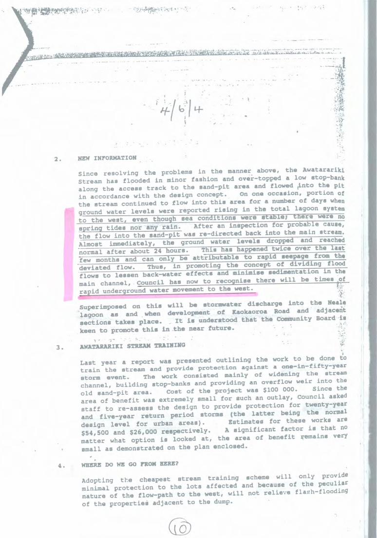
;− •
_
1 4−
,2 . NEW INFORMATION
S i n c e r e s o l v i n g t h e p r o b l e m s i n t h e manner. a b o v e , t h e Awatarariki
S t r e a m h a s f l o o d e d i n m i n o r f a s h i o n a n d o v e r − t o p p e d a l o w stop−bank
a l o n g t h e a c c e s s t r a c k t o t h e s a n d − p i t a r e a a n d f l o w e d t i n t o t h e pit
i n a c c o r d a n c e w i t h t h e d e s i g n c o n c e p t . On o n e o c c a s i o n , p o r t i o n of
t h e s t r e a m c o n t i n u e d t o f l o w i n t o t h i s a r e a f o r a number o f d a y s when
g r o u n d w a t e r l e v e l s w e r e r e p o r t e d r i s i n g i n t h e t o t a l l a g o o n system
t o t h e w e s t , e v e n t h o u g h s e a c o n d i t i o n s w e r e s t a b l e ; t h e r e w e r e no
s p r i n g t i d e s n o r a n y r a i n . A f t e r a n i n s p e c t i o n f o r p r o b a b l e cause,
t h e f l o w i n t o t h e s a n d − p i t w a s r e − d i r e c t e d b a c k i n t o t h e m a i n stream.
A l m o s t I m m e d i a t e l y , t h e g r o u n d w a t e r l e v e l s d r o p p e d a n d reached
n o r m a l a f t e r a b o u t 2 4 h o u r s . T h i s a s h a p p e n e d t w c c o v e r t h e l a s t
f e w m o n t h s a n d c a n o n l y b e a t t r i b u t a b l e t o r a p i d s e e p a g e f r o m t h e
d e v i a t e d f l o w . T h u s , i n p r o m o t i n g t h e c o n c e p t o f d i v i d i n g f l o o d
f l o w s t o l e s s e n b a c k −w a t e r e f f e c t s a n d m i n i m i s e s e d i m e n t a t i o n i n the
i n c h a n n e l _ C o u n c i l h a s now t o r e c o g n i s e t h e r e w i l l b e t i m e s o f
r a p i d u n d e r g r o u n d w a t e r movement t o t h e west.At. S u p e r i m p o s e d o n t h i s w i l l b e s t o r m w a t e r d i s c h a r g e i n t o t h e Neale
l a g o o n a s a n d w h e n d e v e l o p m e n t o f K a o k a o r o a Road a n d adjaceit
s e c t i o n s t a k e s p l a c e . I t i s u n d e r s t o o d t h a t t h e Community B o a r d −is
_ k e e n t o p r o m o t e t h i s L a t h e n e a r future.
3 . AWATARARIII STREAM TRAINING
L a s t y e a r a r e p o r t w a s p r e s e n t e d o u t l i n i n g t h e w o r k t o b e done to
t r a i n t h e s t r e a m a n d p r o v i d e p r o t e c t i o n a g a i n s t a one−in−fifty−year
s t o r m e v e n t . T h e w o r k c o n s i s t e d m a i n l y o f w i d e n i n g t h e stream
c h a n n e l , b u i l d i n g s t o p − b a n k s a n d p r o v i d i n g a n o v e r f l o w w e i r i n t o the
o l d s a n d − p i t a r e a . C o s t o f t h e p r o j e c t w a s $ 1 0 0 0 0 0 . S i n c e the
a r e a o f b e n e f i t w a s e x t r e m e l y s m a l l f o r s u c h a n o u t l a y , C o u n c i l asked
s t a f f t o r e − a s s e s s t h e d e s i g n t o p r o v i d e p r o t e c t i o n f o r twenty−year
a n d f i v e − y e a r r e t u r n p e r i o d s t o r m s ( t h e l a t t e r b e i n g t h e normal
d e s i g n l e v e l f o r u r b a n a r e a s ) . E s t i m a t e s f o r t h e s e w o r k s are
$ 5 4 , 5 0 0 a n d $ 2 6 , 0 0 0 r e s p e c t i v e l y . A s i g n i f i c a n t f a c t o r i s t h a t no
m a t t e r w h a t o p t i o n i s l o o k e d a t , t h e a r e a o f b e n e f i t r e m a i n s very
s m a l l a s d e m o n s t r a t e d o n t h e p l a n enclosed.
4 . WHERE DO WE G o FROM BEM
A d o p t i n g t h e c h e a p e s t s t r e a m t r a i n i n g s c h e m e w i l l o n l y provide
m i n i m a l p r o t e c t i o n t o t h e l o t s a f f e c t e d a n d b e c a u s e o f t h e peculiar
n a t u r e o f t h e f l o w − p a t h t o t h e w e s t , w i l l n o t r e l i e v e fla01−flooding
o f t h e p r o p e r t i e e a d j a c e n t t o t h e dump.
cLo
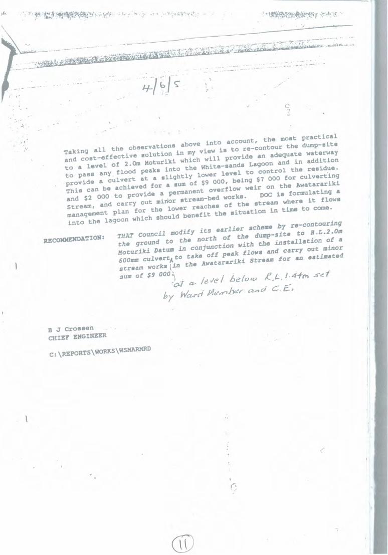
− −•
•
•••
•••
• −•• • :Li
C.
• ••••
T a k i n g a l l t h e o b s e r v a t i o n s a b o v e i n t o a c c o u n t , t h e m o s t practical
a n d c o s t − e f f e c t i v e s o l u t i o n i n my v i e w i s t o r e − c o n t o u r t h e dump−site
t o a l e v e l o f 2 . 0 m M o t u r i k i w h i c h w i l l p r o v i d e a n a d e q u a t e waterway
t o p a s s a n y , f l o o d p e a k s i n t o t h e W h i t e− s a n d s L a g o o n a n d I n addition
.p r o v i d e a c u l v e r t a t a s l i g h t l y l o w e r l e v e l t o c o n t r o l t h e residue.
T h i s c a n b e a c h i e v e d f o r a sum o f $9 0 0 0 , b e i n g $ 7 0 0 0 f o r culverang
a n d $ 2 0 0 0 t o p r o v i d e a p e r m a n e n t o v e r f l o w w e i r o n t h e Awatarariki
S t r e a m , a n d c a r r y o u t m i n o r s t r e a m−b e d w o r k s . DOC i s f o r m u l a t i n g a
m a n a g e m e n t p l a n f o r t h e l o w e r r e a c h e s o f t h e s t r e a m w h e r e i t flows
i n t o t h e l a g o o n w h i c h s h o u l d b e n e f i t t h e s i t u a t i o n i n t i m e t o come.
RECOMMENDATION: THAT C o u n c i l m o d i f y i t s e a r l i e r s c h e m e b y re−contouring
t h e g r o u n d t o t h e n o r t h o f t h e d u m p − s i t e t o R.L.2.0m
M o t u r i k i Datum i n c o n j u n c t i o n w i t h t h e i n s t a l l a t i o n o f a
600mm c u l v e r t A t o t a k e o f f p e a k f l o w s a n d c a r r y o u t minor
s t r e a m w o r k s t i n t h e A w a t a r a r i k i S t r e a m f o r a n estimated
sum o f $ 9 0 0 0 : \ .) .' e l at,
/e_ V e / .6 e. f o cvie.
.I •
4−1−01 −−−cei
L −I, P6reli /4?' 4 Yiyer 61, 6,41 C. E" ,
B j Cross'CHIEF ENGINEER
C:\REPORTS\WORKS\WSMARNED

)4)9
BAY O F PLENTY REGIONAL COUNCIL
REPORT TO:
FROM:
DATE:
R B GardnerManager Environmenta l Regulat ion andMonitoring
P D DineManager Design
4 April 1991
FILE REFERENCE: 1370 0 2 2539
SUBJECT: WATER RIGHT APPLICATION NO 2 5 3 9 −WHAKATANE DISTRICT COUNCIL •
1.0 INTRODUCTION
My n a m e i s Peter Dine. I a m employed a s Manager Design b y theBay o f Plenty Regional Council.
I will present evidence on:
(a) Existing flooding within the Richmond Street North sub−division.
(b) The effects o f the works proposed b y the Whakatane DistrictCouncil.
2 . 0 BACKGROUND
The above application concerns works required to mitigate floodingo f residential sections in the northern end o f Richmond Street,Matata. Part o f the sub−division lies i n a n old bed o f the Tarawera
_River. Specifically the proposals will protect the area from floodingfrom the Awatarariki Stream, with a return period o f 5 years. Theproposal also se ts out to reduce the effects o f flooding with streamfloods o f a greater frequency than five years.
3 .0 FLOODING IN SUBDIVISION
'the Regional Council does not have any records o f flooding in thisarea b u t some 'data has been obtained from the District Council.Specifically data at normal water levels, during Cyclone Bola, and thestorm of 2 2 January 1989 have been studied. It would appear thatoverflows from the Awatarariki Stream, only In very large eventsdirectly enter the subdivided area. ...Most water enters the subdivisionb y way of percolation, direct from the stream, and ponding in the
pp
(41 tosand pit. This percolation is understandably rapid in the porouss a n d s i n the area. It would b e reasonable to a s s u m e that this i s notthe only groundwater entering the lagoon system, and there i s alsothe possibility that elevated s e a levels will induce seepage though Iunderstand n o evidence o f salt water h a s been detected.
Drainage of the lagoon system is via seepage which m u s t b e directlycontrolled b y s e a levels. Clearly elevated s e a levels will restrictdrainage.
4 . 0 DISTRICT COUNCIL PROPOSAL
The applicant wishes to train the lower portion o f the stream andprovide for a controlled overflow into the old sand−pit area. This willb e a big improvement o n the existing situation where flows a s low
a s 1 cumec would spill into the sandpit area. The works will alsoprevent any direct flow to the sub−division. The controlled overflowwill only come into operation w h e n flows exceed 6 cumecs andduring the design storm a total o f 3 7 , 0 0 0 m ' o f water will b e spilt.This water then, can percolate directly to the sea, to Matata Lagoonor into the sub−division. Should a s m u c h a s 50% o f this water findits way into the remnant lagoons it will result in a rise i n water levelo f slightly more than 1.0m. This situation would b e a n absoluteextreme a s it h a s assumed n o drainage o f the lagoon over a periodo f several hours, a condition which could only b e reached should thewhole area become sealed. There i s however a n unknown amounto f additional seepage from other sources which elevate lagoon levels.
5 . 0 CYCLONE BOLA EVENT
This event had relatively high s e a levels b u t fairly insignificantrainfall. The h o u s e lagoon level r a l e to RL 1.7m b u t droppedrapidly. The White Sands lagoon roseito RF 1.3m b u t dropped moreslowly.
6 . 0 JANUARY 1 9 8 9 EVENT
This event had very high rainfall (about 5 year return period over 24hours) and resulted in levels o f RL 2 . 1 6 m and RL 1.90m i n theHouse and White Sands Lagoons respectively. The conclusion drawnfrom these figures i s that the small house lagoon responds morerapidly and severely to both s e a and storm and rain storm events.Providing a direct connection between these two lagoons will clearlyreduce the height to which the House Lagoon is currently subject tob u t will also increase the time elevated water levels occur. Thelagoons were at one time naturally connected b u t the, Matata dump
• h a s cut this connection and reduced the size o f the House Lagoon.
7 .0 OBJECTIONS •
Some of the objections to the application have been addressed in thetext above b u t taking each in turn.
111 7.1 Flooding of the Residential sub−division is partly attributable tooverflows from the Awatarariki Stream.

r it:
7 . 2 This flooding will undoubtedly cause hardship b u t to s o m e extent willb e unavoidable because of the very low lying old river bed area being
(−)1+ Ill
subject to large seepage flows.
III 7 . 3 A degree of flooding could b e expected with every major s e a stormor rainfall event. Levels u p to RL 1.5m could b e expected perhapsa n y.
7 . 4 Further development within the approved sub−division will no t effect− flooding a s soils are s o porous, water will find its w a y to the water
table almost immediately, irrespective o f the amount o f development.The rate water runs off the area will no t affect the water table.Further sub−division will be subject to planning approval and it isunlikely that such approvals would b e given which could .affect thisarea. There would appear to b e little scope for subdivision anywaywithin the area.
7 .5 The stream is not being diverted a s such, b u t controlled to spill acertain volume o f water, into a n area where it currently spillsnaturally.
8 . 0 CONCLUSIONS
The main conclusions to be drawn are:−
(a) The District Council proposal i s sound in that it will improvethe current situation.
(b) The proposed "balancing" culvert will reduce the level offlooding in the house lagoon and i s o f sufficient size andcorrect level.
(c) The subdivision will always b e subject to some degree offlooding.
•
(d) The old Matata dump h a s aggravated the situation mainly i nreducing the area available for ponding. Overall the effect issmall.
P D Dine •MANAGER DESIGN
*
ors \ n−lem\9 1 040211c

.114C−ctli," • ,04.1;Tr. −
N o 7 2 5 3 9 / 3
BAY OF PLENTY REGIONAL COUNCIL
RIGHT IN RESPECT OF NATURAL WATER
Pursuant to Section 16(1)(d) o f the Final Reorganisation Scheme for the Bay
of Plenty Region and Section 21(3) of the Water and Soil Conservation Act
1967, THE BAY OF PLENTY REGIONAL COUNCIL, b y a decision dated 16
May 1991, HEREBY GRANTS to:
WHAKATANE DISTRICT COUNCIL
Private Bagitfittr WHAKATANE
a right to DIVERT AND DISCHARGE WATER FLOWS VIA A BALANCING
CULVERT BETWEEN TWO EXISTING REMNANT LAGOONS subject to the
following conditions:
1. PURPOSEFor t h e purpose of balancing levels between two remnant lagoons
(known as Neale Lagoon and White Sands Lagoon) in a former bed of
the Tarawera River.
2 . LOCATIONBalancing weir to be installed as shown on BOPRC Plan No WR2539submitted with the application.
3. MAP REFERENCE1
(NZMS 2 6 0 V15:395620
4„ WORKS1 4.1 The balancing culvert shall b e installed i n accordance with the
proposal s e t o u t i n the report, "Application for Right in Respectof Natural Water − Matata", accompanying the application.
1 4.2 The invert level of the balancing culvert shall b e s e t a t 1.0m,
(Moturiki datum),1,
4.3 The Grantee shall, to the satisfaction of the General Manaier
of the Regional Council or his delegate, take every care during
1 the works to minimise the discharge of sediment to natural
water. ..
4.4 Protection measures, to the satisfaction of the General Managerof the Regional Council or his delegate, shall be installed by the
Grantee at each end of the balancing culvert to minimiseerosion.
− No 2 5 3 9 / 3
4 . 5 The Grantee shall, to the satisfaction o f the General Managero f the Regional Council or h i s delegate, install screens a t eachend o f the balancing culvert to prevent blockage o f the culvert.
4 . 6 The Grantee shall install a wide dished channel along the samealignment a s the balancing culvert to convey flows i n excess ofthose pass ing through the balancing culvert.
4 . 7 The invert level o f the dished channel shall b e 1.6m (Moturikidatum).
4 . 8 The Grantee shall to the satisfaction o f the General Manager oft h e Regional Council or h i s delegate, maintain the dishedchannel i n a condition which will ensure the free passage ofexcess surface water between t h e two lagoons.
5 . TERM OF RIGHTThis Right shal l terminate o n 3 1 May 2002.
6 . THE RIGHT hereby authorised i s granted under the Water a n d SoilConservation Act 1967 and does n o t constitute a n authority undera n y other Act, Regulation or By−Law.
7 . T H E REGIONAL COUNCIL i s to b e excluded from a n y liability for lossor damage to the Grantee's structures or works i n the event o f flood,or for damage caused to any land i n t h e event o f flood water reachings u c h land d u e to any works or actions taken b y the Grantee inrespect o f this Right.
DATED a t Whakatane this 2 2 n d d a y o f J u l y 1991
For and o n behalf ofThe Bay Of Plenty Regional Council
A JONESGENERAL MANAGER

Page 1 of 1
Rh olite Farm
From: "Rhyolite Farm" <[email protected]>To: <[email protected]>Cc: <[email protected]>Sent: Friday, 18 May 2018 12:00 p.m.Subject: A.G.S Journal L.R.M , commentDear Councils , After 13 years to the day, you have found yet another good way to further irritate , frustrate and stress the victims of adisaster by giving them a scientific journal to read and pass comment on.
i had trouble with the abbreviations used with no legend to help, my intial reaction was W.T.F ,which i can tell you is,Wonderful Truly Fantastic , which is more than i can say about the A.G.S chairmans column on page V talking about measuring andrecording of C.P.D , which i still have no clue to the meaning of after reading the journal , i wonder if you can understand how that sets alayman up for trying to take in the next 260 pages that followed.
The journal falls short on purpose , as it is AUSTRALIAN , based on a sun baked country with long dry periods [ sometimesyears ] and then cyclones to saturate the soils and activate the next landslide. It has no comparison with the land of the long white cloudsclimate
Even their assessment of the Pittwater area falls flat. In that of the 193 landslides in 34 years only 7 were natural slopefailures , 25 where rockfalls from coastal cliffs and the other 161 , thats 161 where cut and fills from building of houses , thats building ofhouses on slopes, no one is building houses up in the Awatarariki catchment behind Matata causing slips, so a non applicable report inan irrelevant journal to Matata's geology.
There is one 10 lettered word we use a lot here in New Zealand with relation to landslide disasters, and i did not see onemention of it in the 269 pages, so that proves just how dissimilar our countries are ,
and how using this journal for anything in NZ wouldnot pass scrutiny, in say the environment court.
In conclusion , council may have purchased the wrong journal , find the one that outlines when the next rainfall event, likethe one 13 years ago is likely to hit Matata , that journal will prove what the state of risk on the fanhead is , because to date council haveonly written the word HIGH and could just as easily have written LOW, without a rainfall journal council are left with no proof the risk isHIGH , landslides and log dams have been coming and going in the Awatarariki catchment for hundreds of years, it was very high rainfallthat caused the problem, so please, find a rainfall journal and swap it for this one on landslides.
mother Nola NealeAnd a challenge to anyone with time to spare −find the meaning of C.P.D on page v , using only the journalbecause i will ask what page it was onand if you find the 10 lettered word earthquakewhat page that was on , good luck
Yours faithfully,Keith Sutton,
for myself and on behalf of my
8/09/2018

EARTHQUAKESWARM
What distinguishes earthquakes in the centralNorth Island is that they are very shallow,usually less than 10 km deep. This means thateven relatively small earthquakes can be feltquite strongly close to their source.In January 2005 an earthquake swarm started justa few kilometres west of the small Bay of Plentycoastal setdement of Matata. At first GNS Scienceseismologists thought it would follow thepattern of most swarms, quite intense activity fora few days after which it would die way.However the swarm steadily grew and peakedin April when GeoNet located more than 10earthquakes a day in the area with the largestearthquake being magnitude 4.1. In August theswarm started to settle down and by Decemberthe earthquakes had almost stopped. By the endof 2005, GeoNet had located more than athousand earthquakes in the Matata area.Through most of 2006 Matata was quiet,but in December the earthquakes started again.This time about half were near Matata and therest beneath the sea about 10 km to the north.The number of earthquakes peaked in April andMay, the largest being magnitude 4.2 on April 3.The earthquakes then followed the same patternas 2005 and started to slowly die away.Seismologists were surprised when the swarmsuddenly picked up again in September withfour earthquakes above magnitude 4, includingtwo shakes of magnitude 4.7 and 43 early on themorning of September 30. The largest of thesewas felt along the Bay of Plenty coast fromWaihi to Opotiki and as far south as Rotorua.GeoNet received more than 400 felt reportsvia its web−based felt reporting system.The magnitude 4.7 earthquake was felt moststrongly in Matata and Edgecumbe where somereported it strong enough to do minor damage.
5 krns
sfrob
Between January and early October 2007,GeoNet located another thousand earthquakesin the Matata area, with two new permanent sitesclose to Matata helping collect additional dataon the swarm.By using the detailed recordings of the earthquakewaves recorded by nearby GeoNet seismographs,Stephen Bannister from GNS Science has beenable to show that the earthquakes are occurringin several distinct groups, both close to Matataand out to sea in a north−easterly direction.The area around Matata has many distinct north−easterly trending active fault lines, so it is likelythat the earthquakes are produced by movementon some of these faults. Fellow GNS scientistTony Hurst has shown that the style of faultingthat caused the 2005 earthquakes is consistentwith these north−easterly trending active faultlines and possibly a result of crustal extensionin a northwest−southeast direction. For thesereasons seismologists think it is unlikely thatsome kind of volcanic activity is going onbeneath the Bay of Plenty.
One of the great difficulties in dealing withearthquake swarms is the fact that they oftendon't follow the mainshock−aftershock pattern.For this reason seismologists don't know howlong a swarm will continue and the size of thelargest earthquake that might be expected.Victoria University seismologist Euan Smithand international collaborators are now planningto use the GeoNet earthquake database to lookfor patterns in other central North Islandearthquake swarms and try to answer someof these questions.
In the meantime the GeoNet seismographscontinue to keep a close watch on the Mau taarea and you can follow the bigger shakes onthe GeoNet websitc.contact Steve Sherb urnEmail: s.sherburningns.cri.nz
Above:The complex, changing patternof where the Matata earthquakeshave actually occurred.2000 earthquakes are shown in blue.2006 in green, and red circles showthe 2007 activity The burst of largeearthquakes in late September 2007is shown by the largest red circles.The kneations sugge st that theearthquakes are occurringon active fault lines_
GeoNet—

,What distinguishes earthquakes in the centralNorth Island is that they are very shallow,usually less than 10 km deep. This means thateven relatively small earthquakes can be felt
qu ite strongly dose to their source.In January 2005 an earthquake swarm started justa few kilometres west of the small Bay of Plentycoastal settlement of Matata. At first GNS Scienceseismologists thought it wouhl follow thepattern of most swarms, quite intense activity for
a few Jays after which it would die way.However the swarm steadily grew and peakedin April when GeoNet located more than 10earthquakes a day in the area with the largestearthquake being magnitude 4.1. In August theswami started to settk down and by Decemberthe earthquakes had almost stopped. By the endof 2005, GeoNet had located more than athousand earthquakes in the Matata area.Through most of 2006 Matata was quiet,but in December the earthquakes started again.This time about half were near Matata and therest beneath the sea about 10 km to the north.The number of earthquakes peaked in April andMay, the largest being magnitude 4.2 on April 3.The earthquakes then followed the same patternas 2005 and started to slowly die away.Seismologists were surprised when the swarmsuddenly picked up again in September withfour earthquakes above magnitude 4, including
two shakes of magnitude 4.7 and 43 early on themorning of September 30. The largest of thesewas felt along the Bay of Plenty coast fromWaibi to Opotiki and as far south as Rotorua.GeoNet received more than 400 felt reportsvia its web−based felt reporting system.The magnitude 4.7 earthquake was felt moststrongly in Mama and Ed gecumbe where somereported it strong enough to do minor damage.
,
Between January and early October 2007,GeoNet located another thousand earthquakesin the Matata arca, with two new permanent sitesdose to Matata helping collect additional dataon the swarm.By using the cietaAod reconlirgs of the earthquakewaves recorded by nearby GcoNet seismographs,Stephen Bannister from GNS Science has beenable to show that the earthquakes are occurringin several distinct groups, both close to Matataand out to sea in a north−easterly direction.The area around Matata has many distinct north−easterly wending active fault lines, so it is likelythat the earthquakes are produced by movementon some of these faults. Fellow GNS scientistTony Hurst has shown that the style of faultingthat caused the 2005 earthquakes is consistentwith these north−easterly trending active faultlines and possibly a result of crustal extensionin a northwest−southeast direction. For thesereasons seismologists think it is unlikely thatsome kind of volcanic activity is going onbeneath the Bay of Plenty.
One of the great difficulties in dealing withearthquake swarms is the fact that they oftendon't follow the mainshock−aftershock pattern.For this reason seismologists don't know hoselong a swarm will continue and the size of thelargest earthquake that might be expected.Victoria University seismologist Euan Smithand international collaborators are now planning,to use the GcoNet earthquake database to lookfor patterns in other central North Islandearthquake swarms and try to answer someof these questions.
In the meantime the GeoNet seismographscontinue to keep a close watch on the Maur.'area and vou can follow the bigger shakes onthe GeoNet website.Contact Steve She rb urn
s.sherburn4gnst ri.nz
Above:The complex, changini&whore the. Matata eshave actually °comet2045 earthquakes are sM B gieen, aR4 redthe 2007 activity The bearthquakes in late Se;is shown b y t e bilesThe lineations suggestearthquakes are occurMt active fault km&
ilff/si OA/ 771−sy 60/7,−.47
2;00sa,i


1
Form 5 Submission on notified proposal for policy statement or plan, change or variation
Clause 6 of Schedule 1, Resource Management Act 1991
To: Whakatāne District Council Name of submitter: KiwiRail Holdings Limited This is a submission on the following change proposed to the plan: Whakatāne District Plan ‐ Plan Change 1: Awatarariki Fanhead, Matatā Trade Competition KiwiRail could not gain an advantage in trade competition through this submission.
1. The specific provisions of the proposal that KiwiRail’s submission relates to are:
KiwiRail opposes in part proposed Rule 18.2.6.3 (c). KiwiRail’s submission is: PC1 provides for the ongoing use and maintenance of network utilities through the Awatarariki fan head area as a permitted activity. Rule 18.2.6.3 provides for the upgrading and maintenance of existing network utility and related structures, and this is supported by KiwiRail. However, the Rule appears to restrict network utility works in clause (c) to those ‘in a public place’. While network utilities are often located in/on Council or government managed land which could be viewed as public, the railway corridor is not usually referred to as a public place, nor does the clause cover privately owned sites; which can sometimes host utility and council conduits and pipes. The maintenance and operation of existing utilities on all land should be enabled to retain connections of benefit to the community.
I seek the following decision from the local authority: Amend Rule 18.2.6.3 clause (c) by deleting the words ‘in a public place’ from the end of the clause.
2. The specific provisions of the proposal that KiwiRail’s submission relates to are:
KiwiRail opposes in part proposed Rule 18.2.6.6(c) KiwiRail’s submission is: PC1 provides for the ongoing use and maintenance of network utilities through the Awatarariki fan head area as a permitted activity. Rule 18.2.6.6 provides for the upgrading and maintenance of existing network utility and related structures, and this is supported by KiwiRail. However, the Rule appears to restrict network utility works in clause (c) to those ‘in a public place’. While network utilities are often located in/on Council owned or government managed land which could be viewed as public, the railway corridor is not usually referred to as a public place, nor does the clause cover privately owned sites which can sometimes host

2
utility and council conduits and pipes. The maintenance and operation of existing utilities on all land should be enabled to retain connections of benefit to the community. I seek the following decision from the local authority: Amend Rule 18.2.6.6(c) by deleting the words ‘in a public place’ from the end of the clause.
3. The specific provisions of the proposal that KiwiRail’s submission relates to are: KiwiRail supports proposed Rule 18.2.6.3 (e). KiwiRail’s submission is: PC1 provides for the ongoing use and maintenance of network utilities through the Awatarariki fan head area and this is supported. Rule 18.2.6.3(e) provides for the upgrading and maintenance of existing network utility and related structures. I seek the following decision from the local authority: Retain Rule 18.2.6.3 (e) as notified.
Signature of submitter (or person authorised to sign on behalf of submitter) Date: 14 September 2018 Contact Details Electronic address for service of submitter: [email protected] Telephone: DDI (04) 498 2127 Postal address: Private Bag 593, Wellington 6140 Contact person: Pam Butler, Senior RMA Adviser


Form 5 Submission on notified proposal for policy statement or plan, change or variation
Clause 6 of Schedule 1, Resource Management Act 1991
To: Whakatāne District Council Name of submitter: Matata Residents Association This is a submission on the following change proposed to the plan: Whakatāne District Plan - Plan Change 1: Awatarariki Fanhead, Matatā Trade Competition I could not gain an advantage in trade competition through this submission.
The specific provisions of the proposal that my submission relates to are: All of plan change 1
My submission is: We the Matata Residents Association oppose the plan change We the Residents Assc. want plan change 1 to be put aside until alternative engineering
solutions are fully investigated. I seek the following decision from the local authority: We believe that a combination of engineering mitigation, partnered with connected early warning systems would enable the majority of Awatarariki residents to stay where they are
We request that the Whakatane District Council fully investigate a combination of bunding on the
Awatarariki Stream coupled with an early warning system including rainfall gauges instruments and
ground moisture content monitors.
The bunding would be on the properties of those who have indicated that they wish to be paid out and
leave. This would only require a buyout of 3 houses (#5 and #8 Clem Elliot, #96 Arawa St and 1 section (
#4 Clem Elliot st} and the swapping of houses of those those Living in # 3 Clem Elliot St To #8 Clem
Elliot St thus taking ownership of #3.
This will allow room to create the bunding required, using the material at no cost, that is still sitting in
heaps that were never cleaned up after the debris flow.
The early warning system could be connected to alarms in the individual houses to notify residents of
impending danger and the need to self-evacuate,Thus making the area safe to live in for the majority of
those now living in the Awatarariki area
Hearing submissions
I wish to be heard in support of my submission.
If others make a similar submission, I will not* consider presenting a joint case with them at a
hearing. Signature of submitter Gavin Dennis Date: 13/09/2018] Contact Details Electronic address for service of submitter: [email protected] Telephone: 0273270597 Postal address: P.O.Box 122 Matata 3168 Contact person: Gavin Dennis , Chairman of Matata Residents Association
Note to person making submission If you are a person who could gain an advantage in trade competition through the submission, your right to make a submission may be limited by clause 6(4) of Part 1 of Schedule 1 of the Resource Management Act 1991. Please note that your submission (or part of your submission) may be struck out if the authority is satisfied that at least one of the following applies to the submission (or part of the submission):
it is frivolous or vexatious:
it discloses no reasonable or relevant case:
it would be an abuse of the hearing process to allow the submission (or the part) to be taken further:
it contains offensive language:
it is supported only by material that purports to be independent expert evidence, but has been prepared by a person who is not independent or who does not have sufficient specialised knowledge or skill to give expert advice on the matter.

1
29 November 2017
Attention: Shane McGhie
Principal Planner
Whakatane District Council
Private Bag 1002
Whakatane 3165
Tena koe Shane
PROPOSED PLANNING PROVISIONS FOR DEBRIS FLOW RISK MANAGEMENT ON THE AWATARARIKI
FANHEAD MATATA
Thank you for seeking comment from Te Runanga o Ngati Awa on proposed new planning provisions
in the district plan for debris flow risk management on the Awatarariki Fan-head at Matata.
Council has invited Ngati Awa comment on the proposed plan change to the Operative Whakatane
District Plan and the proposed plan change 14 to regional councils Regional Natural Resources
Management Plan (Natural Hazards).
Retreat Option
Te Runanga o Ngati Awa acknowledges that while the option of retreat has been identified by
Council since 2005, Council invested significantly in exploring several engineered design options in
genuine attempts to find an enduring solution that would allow people to continue living in safety in
their homes on the Awatarariki fan-head which remains vulnerable to future debris and flood flows.
Twelve years have passed and residents who have endured significant challenges that uncertainty of
uncertainty now face a most serious and difficult challenge, the prospect of needing to retreat their
homes from a location that remains in harm’s way in the lowest extent of Te Awatarariki stream
catchment.
While people may not know when a similar event to that of 18 May 2005 will occur, the geography
of the catchment and the difficulty experienced in managing soil stability in the catchment indicates
that similar events are likely to occur in future.
In its 2009 assessment of the proposed Awatarariki Flexi-Net Debris Detention Structure option, Te
Runanga o Ngati Awa commented:

2
A ‘potential alternative solution is to require homes in the lower Awatarariki catchment to
retreat from the flow path of future debris and flood flows they (the homes) are vulnerable
to’.
Today it is clear that every option that aimed to allow people to remain in their homes at this
location has now been exhausted.
Te Runanga o Ngati Awa considers the proposed retreat option will:
remove homes and families from a location that is in harm’s way
bring certainty to these families and the community
ensure central government agencies contribute financially to the relocation of families into
new homes in a safe location
protect people from making future investments in residential subdivision at this location by
inserting a prohibited activity rule for residential development at this location which would
place people in harms way, at night, when they and their families and any guests are
sleeping.
the prohibited activity status will protect people from making future investments in building
their homes in this high-risk location
the permitted activities status will allow for people to continue to enjoy appropriate
activities at the location
When the proposed planning provisions are notified for public submissions Te Runanga o Ngati Awa
will make submission to each of the proposed plan changes.
Enquiries regarding these comments should be directed to Beverley Hughes at [email protected]
in the first instance.
Kia ora,
Leonie Simpson
CHIEF EXECUTIVE
Email copy to:
Stan Ratahi, Ngati Hikakino Hapu Representative, Te Runanga o Ngati Awa
Amohaere Tangitu, Te Tawera Hapu Representative, Te Runanga o Ngati Awa
Manu Glen, Ngai Te Rangihouhiri Hapu Representative, Te Runanga o Ngati Awa
Enid Ratahi-Pryor, Ngai Taiwhakaea Hapu Representative, Te Runanga o Ngati Awa
Miro Araroa, Rangitaiki Hapu Coalition, Te Runanga o Ngati Awa
Keri Topperwien, Consent Coordinator Te Runanga o Ngati Awa
Christopher Clarke, Kaitiaki, Te Mana o Ngati Rangitihi
Elaine August, Kaitiaki, Tuwharetoa BOP Settlement Trust
Martin Butler, Senior Planner, Bay of Plenty Regional Council

Mon 18-Jun-18 5:40 PM Bev Hughes [email protected] RE: Proposed Plan Change 17 (Awatarariki Fanhead) to the Bay of Plenty Regional Natural Resources Plan and Proposed Plan Change 1 (Awatarariki Fanhead, Matata) to the Whakatane District Plan To: Marie Radford [email protected] CC: Leonie Simpson [email protected]; Jeff Farrell [email protected]; Martin Butler [email protected] Kia ora koutou Thank you for providing a copy of the proposed plan change. Te Runanga o Ngati Awa provided the attached letter in November 2017. It appears the proposed plan change will achieve the outcomes we sought in our attached letter. Please therefore receive this letter again – as a submission in support of the proposed plan changes – for reasons outlined in the letter. TRONA also promotes with Councils their awareness and provisions for the reserve area in which koiwi recovered from the Matata area have been reinterred.

The reserve area is within the frame above. Ongoing management and monitoring of that reserve area will be required of Council. Council established the reserve for the purposes of re-interment of koiwi discovered in the area. You will recall that the Pan-Tribal CIA we prepared for the Matata Lagoon Recovery Consents recommended that if there was a likelihood of more events like that which occurred on 18 May 2005, a sarcophagus or robust structure should be built at that reserve or the koiwi might be moved to Otaramuturangi Urupa east of the current Tarawera River mouth. A decision on this should be informed by advice from all the pukenga from iwi with relationships with the area and also with the Trustees for Otaramuturangi and the cultural advisors that supported WDC’s establishment of that reserve below Awatarariki. We promote with Councils their taking this matter of national importance into account – by providing appropriate wording into the proposed plan change. TRONA does not wish to be heard, but will contribute advice if information about the reserve is required.

Due to a lack of capacity here, and in recognition of Local Government agencies responsibility to foster our capacity to contribute to its decision-making – we request a collegial conversation about the wording for the reserve area mentioned above – rather than being required to prepare and attend a hearing on that matter– please and encourage Councils to convene those people it needs to convene – to discuss the alternative identified above Thank you so much
Beverley Hughes
Manager Policy & Strategy
Environment, Economic, Social
Te Rūnanga o Ngāti Awa
PO Box 76
Whakatane 3165
Phone 07 30 70 760 extension 237
Cell 0274 711 806 (text preferred)


![THE WXRED SOCIETY: PROMISE AND PERFORMANCE - [email protected]: Home](https://img.dokumen.tips/doc/110x75/61fb74122e268c58cd5e58e9/the-wxred-society-promise-and-performance-emailprotected-home.jpg)


