Embed Size (px)
Citation preview
8/6/2019 Buss Et Al. - 2010 - 3D-Model of the Deep Geothermal Potentials of the Northern Rhine Rift Valley
http://slidepdf.com/reader/full/buss-et-al-2010-3d-model-of-the-deep-geothermal-potentials-of-the-northern 1/5
Proceedings World Geothermal Congress 2010
Bali, Indonesia, 25-29 April 2010
1
3D-Model of the Deep Geothermal Potentials of the Northern Rhine Rift Valley
Arne Buss, Kristian Baer, Ingo Sass
Institute of Applied Geosciences, Technische Universität Darmstadt
Keywords: Rhine Rift Valley, 3D-Model, geothermal
potential, thermal conductivity, permeability
ABSTRACT
Based on a 3D geological model of the geology and
structure of the northern Rhine Rift Valley a geothermal
model has been developed. Systematic measurements of
permeabilities and thermal conductivities of relevant
geologic formations have been combined with in situ
temperature measurements, hydrothermal upwelling zones,
characteristics of geological faults and added to the
geological model. The model is an important tool for theplanning of geothermal power plants because it will allow
the geothermal potential to be easily determined at an early
stage of the planning phase.
1. INTRODUCTION
For the planning of deep-geothermal installations,
knowledge of the geological structure and the geothermal
parameters of the potential reservoir rocks is indispensable.
Therefore a 3D model of the deep geothermal potential of
Hesse has been carried out (Arndt et al. 2009).
2. GEOLOGY
In the Hessian part of the Rhine Rift Valley the quarternarysediments with up to 340 m thickness (Haimberger et al.,
2005) can be neglected from the deep geothermal model.
These formations are underlain by 500 - 3000 m of Tertiary
calcareous and clastic sediments. The Oligocene
Pechelbronn group with a thickness of 160 - 370 m (Plein,
1992; Boigk, 1981) and permeabilities of 5 ·10-13 m² is the
only relevant geothermal reservoir rock at the base of this
formation. Jurassic and Cretaceous rocks are not present
due to an erosional hiatus. For the Triassic formations,
regionally only the Buntsandstein with a maximum
thickness up to 200 m is present (Boigk & Schoeneich,
1970, 1974). Due to its small thickness and only regional
occurrence it is not relevant for direct geothermal use in
Hesse. The Triassic Formations are underlain by the Permo-
Carboniferous clastic and volcanic formation with a
maximum thickness of up to 2500 m. Because of its depth,
partially high permeabilities and temperature it is the
formation that represents a potential geothermal reservoir.
The uninvestigated crystalline basement has to be regarded
as a petrothermal system because of high temperatures, low
primary permeabilities and high thermal conductivities. It
has to be assumed that the formation consists
predominantly of granitic rocks.
3. GEOLOGICAL 3D-MODEL
The current state of the geological model (Baer, 2008) is
based mainly on already interpreted seismic data, drilling
results and geostructural maps. In the next steps of theproject there will be further refinements of the model,
particularly through the inclusion of additional seismic data.
Layer thicknesses of the main geological units could be
estimated based on the available/published information. As
an example the thickness of the Permo-Carboniferous is
shown in Figure 1, which is increasing towards the
northwest and could reach up to 2000 m in the area west of
Gross-Gerau (Boigk & Schoeneich, 1974). In addition, the
depths of major geological horizons have been determined.
As an example, the depth of the top of the crystalline
basement is represented in Figure 2 with the maximum
depth on the northwestern and southeastern edge of this part
of the rift valley. These two depocenters are separated by an
intervening NE-SW trend epirogene (Derer et al., 2005).
The quality and extension of the 3D-model depends on the
available data. The building of the model with GoCAD has
been mainly carried out based on a method described in
Kaufmann and Martin (2009).
As input data, the digital SRTM model (version 3), 460
drillings, five geological cross sections and four interpreted
seismic sections have been used. Furthermore seven
isopachous and isoline maps for different horizons and five
maps of subsurface temperatures have been taken into
account. With this available data it was possible to carry out
the top ground surface, the quaternary and tertiary basis, the
basis of the mesozoikum and of the permo-carboniferious,
the distribution of the main fault systems and the estimatedtemperature.
4. GEOTHERMAL CHARACTERISATION OF THE
PERMO-CARBONIFEROUS
The lithostratigraphy of the Permo-Carboniferous in the
Hessian part of the Rhine Rift Valley could be structured
with respect to the classification of the Saar-Nahe-Basin.
The focus here is on the Upper Nahe-Group, the Lower
Nahe Group and the Kusel- to Tholey-Group at the bottom
(Henk, 1993; Marell, 1989; Mueller, 1996). Measurements
of the thermal conductivity and the permeability were
conducted on all sedimentary units of the Permo-
Carboniferous both on drill core samples and at samples
taken from neighbouring outcrops as described by Sass etal. (2008).
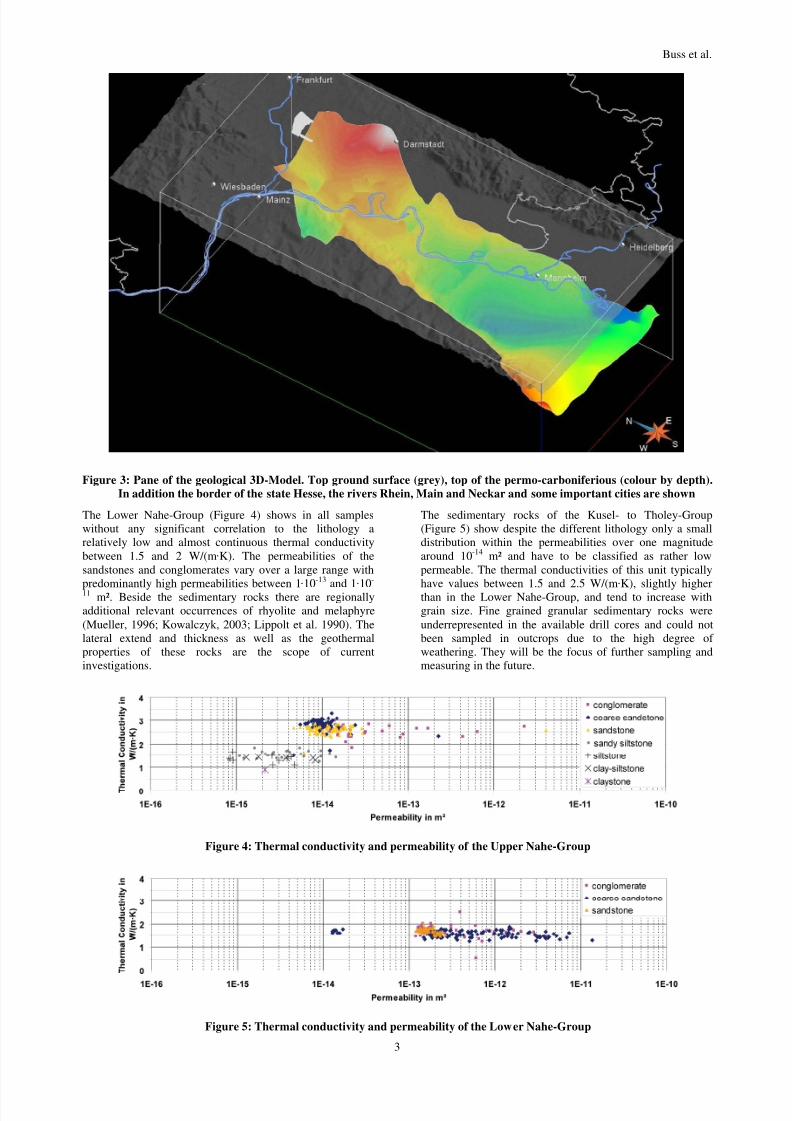
The conglomerates and sandstones of the Upper Nahe –
Group, which occur mostly in the lower part of this unit,
show the highest thermal conductivities of the Permo-
Carboniferous rocks: up to 3.4 W/(m·K). The permeabilities
of the sandstones lie around 1·10-14 m², while those of the
conglomerates are distributed around approximately two
orders of magnitude. The upper part of this unit is
dominated by silt and clay stones which show lower
permeabilities in the order of 1·10-15 to 1·10-14 m² and
substantially lower thermal conductivities of around 1.5
W/(m·K) (Figure 3).

8/6/2019 Buss Et Al. - 2010 - 3D-Model of the Deep Geothermal Potentials of the Northern Rhine Rift Valley
http://slidepdf.com/reader/full/buss-et-al-2010-3d-model-of-the-deep-geothermal-potentials-of-the-northern 2/5
Buss et al.
2
Figure 1: Thickness of the Permo-Carboniferous in the northern part of the Rhine Rift Valley
Figure 2: Depth of the top of the crystalline in the northern part of the Rhine Rift Valley
8/6/2019 Buss Et Al. - 2010 - 3D-Model of the Deep Geothermal Potentials of the Northern Rhine Rift Valley
http://slidepdf.com/reader/full/buss-et-al-2010-3d-model-of-the-deep-geothermal-potentials-of-the-northern 3/5
Buss et al.
3
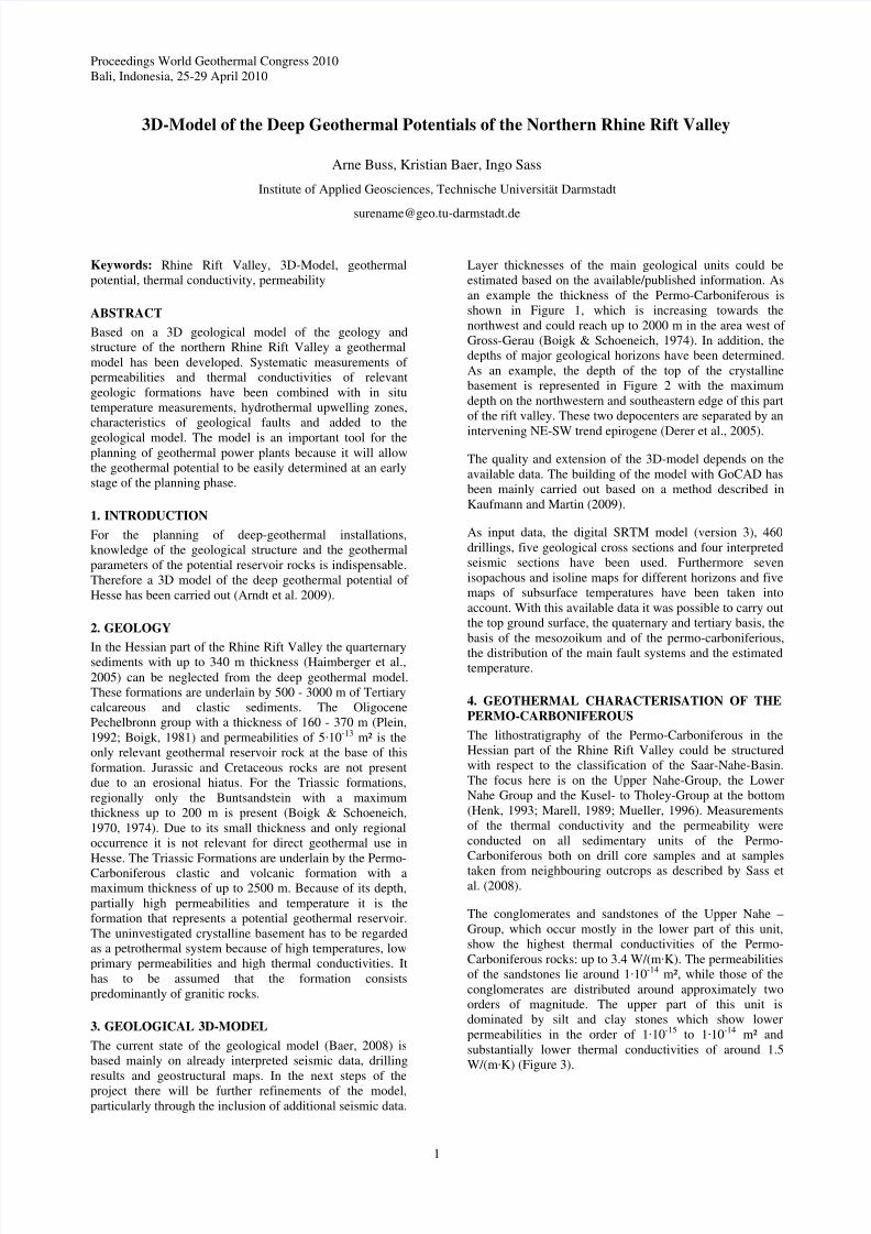
Figure 3: Pane of the geological 3D-Model. Top ground surface (grey), top of the permo-carboniferious (colour by depth).
In addition the border of the state Hesse, the rivers Rhein, Main and Neckar and some important cities are shown
The Lower Nahe-Group (Figure 4) shows in all samples
without any significant correlation to the lithology a
relatively low and almost continuous thermal conductivity
between 1.5 and 2 W/(m·K). The permeabilities of the
sandstones and conglomerates vary over a large range with
predominantly high permeabilities between 1·
10
-13
and 1·
10
-
11 m². Beside the sedimentary rocks there are regionally
additional relevant occurrences of rhyolite and melaphyre
(Mueller, 1996; Kowalczyk, 2003; Lippolt et al. 1990). The
lateral extend and thickness as well as the geothermal
properties of these rocks are the scope of current
investigations.
The sedimentary rocks of the Kusel- to Tholey-Group
(Figure 5) show despite the different lithology only a small
distribution within the permeabilities over one magnitude
around 10-14 m² and have to be classified as rather low
permeable. The thermal conductivities of this unit typically
have values between 1.5 and 2.5 W/(m·
K), slightly higherthan in the Lower Nahe-Group, and tend to increase with
grain size. Fine grained granular sedimentary rocks were
underrepresented in the available drill cores and could not
been sampled in outcrops due to the high degree of
weathering. They will be the focus of further sampling and
measuring in the future.
Figure 4: Thermal conductivity and permeability of the Upper Nahe-Group
Figure 5: Thermal conductivity and permeability of the Lower Nahe-Group

8/6/2019 Buss Et Al. - 2010 - 3D-Model of the Deep Geothermal Potentials of the Northern Rhine Rift Valley
http://slidepdf.com/reader/full/buss-et-al-2010-3d-model-of-the-deep-geothermal-potentials-of-the-northern 4/5
Buss et al.
4
Figure 6: Thermal conductivity and permeability of the Kusel- to Tholey-Group
CONCLUSION
Investigations of permeabilities and thermal conductivities
of the geothermally relevant Permo-Carboniferous rocks
could not demonstrate any significant relationship between
the thermal conductivity and the permeability. It seems that
the sedimentary facies properties are controlling the thermal
charactieristics of the Permo-Carboniferous more strongly
than the petrological composition. The presented results
show that the geothermally relevant rock properties of the
Permo-Carboniferous subunits of different geological ageare not necessarily the same. Due to the increased
permeabilities of the Lower Nahe-Group, this unit is
potentially the most suitable as a hydrothermal reservoir.
The developed 3D-model is a significant improvement of the
previous model and allows a more detailed view into the
northern part of the Rhine Rift Valley and its extension,
especially in terms of the thickness of geothermal relevant
horizons.
PROSPECTS
For the refinement of the model further data must still be
interpreted and implemented. With this refinement the
classification of detailed volume bodies of the individualgeothermally relevant layers for the northern Rhine Rift
Valley should become possible. Furthermore, during further
study, thermal conductivities and permeabilities will be
determined, particularly for the Permo-Carboniferous
volcanic rocks and the fine-grained sedimentary rocks of the
Kusel- to Tholey-Group. On the basis of this relationship
and additional available data a further goal is the estimation
of distinctive geothermal reservoirs.
ACKNOWLEDGEMENT
The authors thank the Hessian Ministry for Economics,
Transport, Urban and Regional Development for founding
the project and the Hessian Agency for Environment and
Geology for the co-operation. In particular we thank Dr.Fritsche, Dr. Kracht and their colleagues for supporting the
project.
REFERENCES Bär, K.: 3D-Modellierung des geothermischen
Tiefenpotenzials des nördlichen Oberrheingrabens und
Untersuchung der geothermischen Eigenschaften des
Rotliegenden. unpublished diploma thesis, Technische
Universität Darmstadt, Institute of Applied Geociences,
(2008)
Boigk, H.: Erdöl und Erdölgas in der Bundesrepublik
Deutschland. Stuttgart,. (1981), 330 pp
Arndt, D., Buss, A., Fritsche, J.-G., Kracht, M., Sass, I.:
Forschungs- und Entwicklungsprojekt „3D-Modell der
geothermischen Tiefenpotenziale von Hessen“.
unpublished project report (2009)
Boigk, H., Schöneich, H.: Die Tiefenlage der Permbasis im
nördlichen Teil des Oberrheingrabens. In: Illies, J.H. &
Mueller, S. [Eds.]. Graben Problems. Proceedings of an
International Rift Symposium held in Karlsruhe, 10-12
October 1968, Stuttgart (Schweizerbart), (1970), 48-55
Boigk, H., Schöneich, H.: The Rhinegraben: geologic
history and neotectonic activity. Perm, Trias und älterer
Jura im Bereich der südlichen Mittelmeer-Mjösen-Zone
und des Rheingrabens. In: Illies, J.H. & Fuchs, K.
[Eds]: Approaches to Taphrogenesis. Proceedings of anInternational Rift Symposium held in Karlsruhe, 13-15
April, 1972: Stuttgart (Schweizerbart), (1974), 60-72
Derer, C.E., Schumacher, M.E. & Schäfer, A.: The northern
Upper Rhine Graben: basin geometry and early syn-rift
tectono-sedimentary evolution. In: Behrmann, J.H.,
Ziegler, P.A., Schmid, S.M., Heck, B. &Granet, M.
(eds.): EUCOR-URGENT Upper Rhine Graben
Evolution and Neotectonics. Int. J. Earth Sci. (Geol.
Rundsch), Berlin, 94, (2005), 640-656
Haimberger, R., Hoppe, A. & Schäfer, A.: High-resolution
seimic survey on the Rhine River in the northern Upper
Rhine Graben. In: Behrmann, J.H., Ziegler, P.A.,
Schmid, S.M., Heck, B. &Granet, M. (eds.): EUCOR-URGENT Upper Rhine Graben Evolution and
Neotectonics. Int. J. Earth Sci. (Geol. Rundsch), Berlin.
94, (2005), 657-668
Henk, A., 1993. Subsidenz und Tektonik des Saar-Nahe-
Beckens (SW-Deutschland). Geol. Rundschau 82, 3-19
Hurter, S. & Schellschmidt, R. (eds): Atlas of geothermal
resources in Europe. Luxembourg, European
Communities (2002), 92 pp.
Kaufmann, O. Martin, T.: Reprint of ‘‘3D geological
modelling from boreholes, cross-sections and
geological maps, application over former natural gas
storages in coal mines’’. Computers & Geosciences, 35,
(2009), 70-82
Kowalczyk, G.: Permokarbon des Sprendlinger Horstes und
der westlichen Wetterau (Exkursion I am 20. April
2001). Jber. Mitt. Oberrhein. geol. Ver ., N.F. Stuttgart,
83, (2001) 211-236
Lippolt, H.J., Kirsch, H. & Plein, E.: Karbonische und
permische Vulkanite aus dem Untergrund des
nördlichen Oberrheingrabens: Art, Altersbestimmung
und Konsequenz. Jber. Mitt. Oberrhein. Geol. Ver ., N.
F., 72, (1990), 227-242
Marell, D.: Das Rotliegende zwischen Odenwald und
Taunus. Geol. Abh. Hessen, Wiesbaden, 89, (1989) 128
pp
Müller, H.: Das Permokarbon im nördlichen
Oberrheingraben – Paläogeographische und strukturelle
Entwicklung des permokarbonen Saar-Nahe-Beckens

8/6/2019 Buss Et Al. - 2010 - 3D-Model of the Deep Geothermal Potentials of the Northern Rhine Rift Valley
http://slidepdf.com/reader/full/buss-et-al-2010-3d-model-of-the-deep-geothermal-potentials-of-the-northern 5/5
Buss et al.
5
im nördlichen Oberrheingraben. Geol. Abh. Hessen,
Wiesbaden, 99, (1996), 85 pp
Plein, E.: Das Erdölfeld Eich-Königsgarten. Jber. Mitt.
Oberrhein. Geol. Ver . N.F., 74,: (1992), 41-54
Sass, I., Buß, A. & Homuth, S.: Permeabilität und
Wärmeleitfähigkeit anisotroper Festgesteine als
Kennwerte für die geothermische Erkundung.
Baugrundtagung, 24.9.-27.9.2008 in Dortmund, (2008)


![Buss Comm1[1]](https://img.dokumen.tips/doc/110x75/577ce35a1a28abf1038be5ce/buss-comm11.jpg)