Embed Size (px)
Citation preview
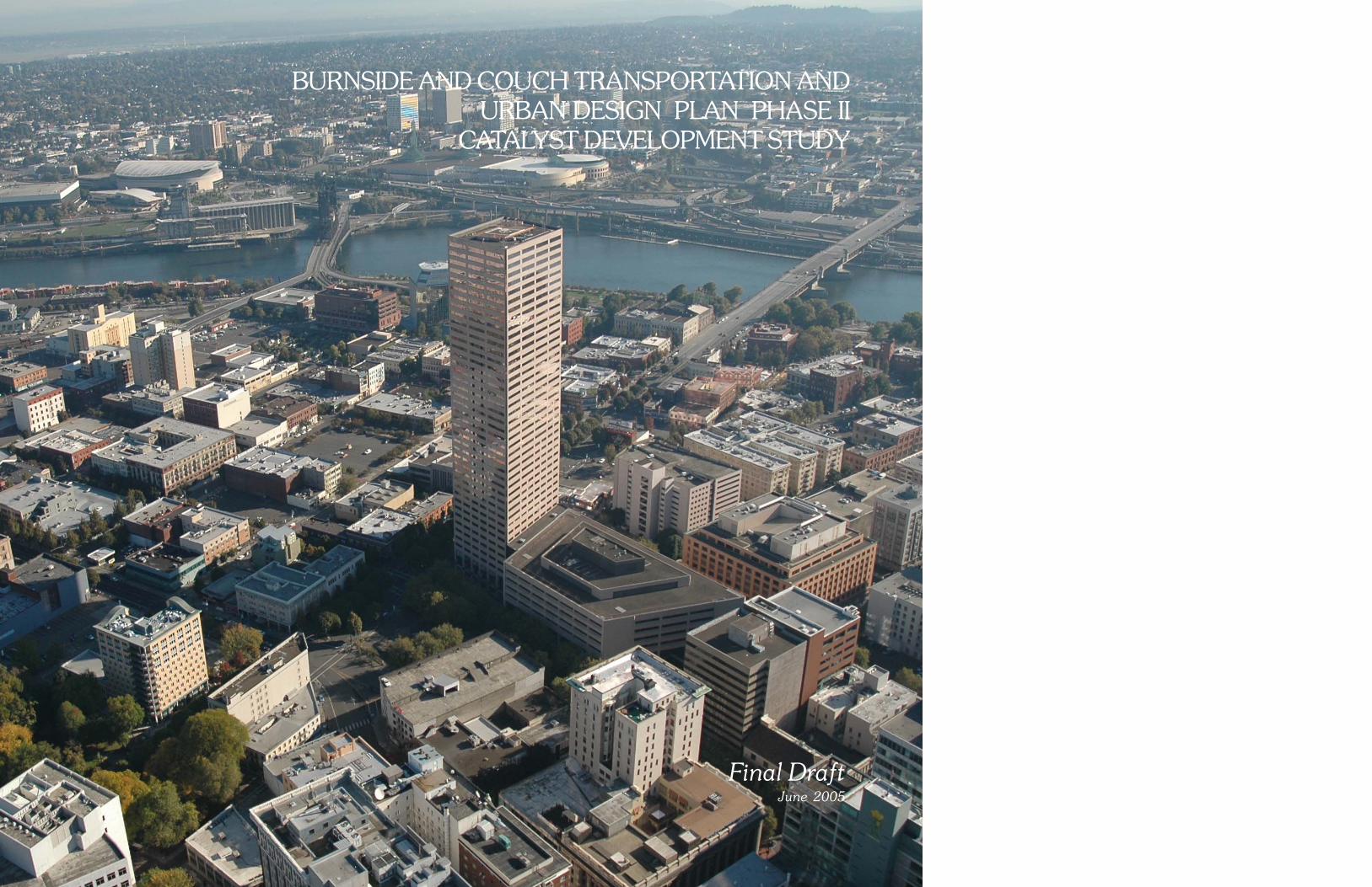
BURNSIDE AND COUCH TRANSPORTATION AND URBAN DESIGN PLAN PHASE II
CATALYST DEVELOPMENT STUDY
Final DraftJune 2005
ACKNOWLEDGMENTS
CITY OF PORTLAND
Tom PotterMayor
PORTLAND DEVELOPMENT COMMISSION
Don MazziottiExecutive Director
Cheryl TweteInterim Director of Development
Lew BowersSenior Development Manager
PROJECT TEAM
Denyse McGriff
Kathryn Krygier
Lisa Abuaf
Leah Halstead Greenwood
Heather Hansen
Christine Hermann
PORTLAND OFFICE OF TRANSPORTATION
Brant WilliamsBureau Director
WIlliam S. HoffmanProject Manager
Doug McCollumTraffic Systems Design Engineer
CONSULTANT TEAMLloyd Lindley
Lloyd D. Lindley, ASLA
Gene CallenGBD Architects
Jerry JohnsonJohnson Gardner LLC
Don SingerIntegra Realty Resources
Peter Finley FryFinley Fry
Craig S. HolmesArtist

TABLE OF CONTENTS
EXECUTIVE SUMMARYIntroduction 1Study Area 2Economic Impact 2Catalyst Development Study Diagram 4Transportation and Urban Design Plan 4Conclusions 6Next Steps 11
Catalyst DEVELOPMENT StudyIntroduction 13Catalyst Development Study Diagram 16Existing Conditions 19Development Advantages 26Development Challenges 27Catalyst Development Sites 29
Lower East Burnside and Couch 29Lower/Central West Burnside and Couch 39Upper West Burnside 45
Investment and Return 47Conclusions 50Next Steps 52
appendixPublic Outreach 53

“The central city is walkable now and will be so in the future. With growingurban intensity and more traffic, this means equitable access to our streetsand public ways for all modes of transportation, while maintaining humanscale and walkability. Additionally, we will build on Portland’s remarkabledesign successes with improvements to Interstate-405, the east bank of theWillamette River, and Burnside Street, as well as other opportunities to upgradethe physical quality of central Portland.”
~A 25-Year Vision for Central Portland April 1999
BURNSIDE AND COUCH transportation and urban design planCATALYST DEVELOPMENT STUDY
Final Draft June 20051
EXECUTIVE SUMMARYIntroduction
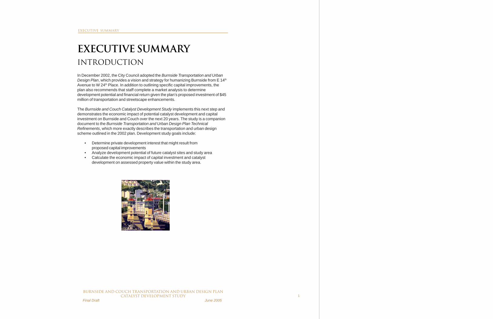
In December 2002, the City Council adopted the Burnside Transportation and UrbanDesign Plan, which provides a vision and strategy for humanizing Burnside from E 14th
Avenue to W 24th Place. In addition to outlining specific capital improvements, theplan also recommends that staff complete a market analysis to determinedevelopment potential and financial return given the plan’s proposed investment of $45million of transportation and streetscape enhancements.
The Burnside and Couch Catalyst Development Study implements this next step anddemonstrates the economic impact of potential catalyst development and capitalinvestment on Burnside and Couch over the next 20 years. The study is a companiondocument to the Burnside Transportation and Urban Design Plan TechnicalRefinements, which more exactly describes the transportation and urban designscheme outlined in the 2002 plan. Development study goals include:
• Determine private development interest that might result fromproposed capital improvements
• Analyze development potential of future catalyst sites and study area• Calculate the economic impact of capital investment and catalyst
development on assessed property value within the study area.
EXECUTIVE SUMMARY

2BURNSIDE AND COUCH transportation and urban design plan
CATALYST DEVELOPMENT STUDY Final Draft June 2005
STUDY AREA
The study area for this report is generally bounded by Davis Street on the north,Ankeny and Ash Streets on the South, E 14th Avenue on the east, and W 24th Placeon the west. Three catalyst development sites were selected for analysis based onthe number of contiguous blocks available for redevelopment, connection to proposedstreet reconfiguration, and the properties’ blighted character. These sites are:
• Site 1. E 12th/Sandy/Burnside/Couch• Site 2. E 3rd/Burnside/Couch• Site 3. W 4th/Burnside/Couch/Ankeny
ECONOMIC IMPACT
The economic impact of catalyst development and construction of transportation andstreetscape improvements was quantified by:
1) Determining feasible development programs for each catalyst site, and2) Using a trending analysis to model the incremental increase in study
area taxable property value (Maximum Assessed Value) and resultantproperty taxes given improvements and potential catalystdevelopment over a 20-year period starting in 2005.
The incremental increase in taxable property value (MAV) was calculated as thedifference between what the trended MAV would be if the project (includingtransportation and urban design improvements and catalyst development) movesforward as envisioned compared to a baseline trending without the project.
The MAV trending analysis divided the study area into three distinct segments:• Lower East Burnside and Couch: from E 14th Avenue to the E
Burnside bridgehead• Lower/Central West Burnside and Couch: from the W Burnside
bridgehead to W 15th Avenue• Upper West Burnside: from W 15th Avenue to W 24th Place
The following table summarizes the public investment, economic return, and physicalimprovements required for and resulting from capital improvements and potentialcatalyst development in each segment of the study area.
○
○
○
○
○
○
○
○
○
○
Catalyst Development Site 1 at NE 12th, Sandy,Burnside and Couch.
Burnside
Sand
y
12th Ave
16th Ave
○○
○○
○○
○○
○○
Catalyst Development Site 2 at NE Burnside,Couch and 3rd Avenue.
Catalyst Development Site 3 at W Burnsidebetween 3rd and 4th Avenues.
Burnside3r
d Ave
Couch○○○○○○○○○
○○
○○
○
○
○
○
○
○
○
○
○
○
○○○○○○○○○○○
4th Ave
○○○○
NE 3rd Ave.
○ ○ ○ ○ ○ ○ ○ ○ ○ ○ ○ ○ ○ ○ ○ ○ ○ ○ ○ ○ ○○
○
○
○
○○
○○
NE Couch
NE Davis
Burnside
NE 2nd Ave.○
○
○ ○ ○ ○ ○ ○ ○ ○ ○ ○ ○ ○ ○ ○ ○ ○ ○
NE MLK
EXECUTIVE SUMMARY

BURNSIDE AND COUCH transportation and urban design planCATALYST DEVELOPMENT STUDY
Final Draft June 20053
INVESTMENT/COST
Flanders
Bike Blvd.1 Lower East
Burnside and Couch
Lower & Central West Burnside and
Couch
Upper West Burnside
STUDY AREA (as available)
Transportation Improvements $3.5 $16 M $17 M $8.5 M $45 Million Development Investment (“Gap Funding”) $0 M $29 M $10 M $0 M $39 Million
Total Project Investment/Cost $3.5 M $45 M $27 M $8.5 M $84 Million
ECONOMIC RETURN
Lower East Burnside
and Couch Lower & Central
West Burnside and Couch
Upper West Burnside
STUDY AREA (as available)
New Net Assessed Value $300 M $425 M $25 M $750 Million
New Net Taxes in Year 202 $7 M/year $9 M/year $.5 M/ year
$16.5 Million/ Year3
(7 year payback after Year 20)
(3 year payback after Year 20)
(17 year payback after Year 20)
(6 year payback after Year 20)
NEW PHYSICAL IMPROVEMENTS Lower East Burnside and Couch Lower & Central West
Burnside and Couch STUDY AREA
(as available) Site Description Site 1
• New commercial and light industrial node at E Burnside and 14th
• Create new multi-family housing to link residential neighborhoods of Buckman and Kerns
• Improve neighborhood connection to adjacent public open space
Site 2 • Gateway development to serve
as catalyst for other redevelopment in the area
• Link the east side of the central city to Downtown Portland
• Create new mixed-use development with housing, light industrial, retail, and other commercial uses
Site 3 • Integrate new mixed-use
development with rehabilitated historic buildings.
• Improve connectivity across Burnside with high-density offices to the south and lower-density housing and retail to the north.
• Active ground floor uses to provide better link to downtown development.
Housing 710 units 350 units 1,060 units Office 411,000 SF 395,000 SF 806,000 SF Retail/Commercial 406,000 SF 87,800 SF 495,000 SF Industrial 35,000 SF 0 SF 35,000 SF Community Services 0 SF 10,300 SF 10,300 SF Hotel 0 rooms 230 rooms 230 rooms Parking 1,975 spaces 934 spaces 2,910 spaces Jobs4 1,880 jobs 1,450 jobs 3,330 jobs
1 The Flanders Bike Boulevard is not within the Catalyst Development Study area, and, therefore, the improvements were not considered as part of the MAV trending analysis. The cost is included here to maintain a consistent project cost in all Phase II documents.
2 Assumes constant property tax rate of 2.2% of Maximum Assessed Value. 3This figure reflects new net taxes in Year 20 only. In addition, there are new net taxes generated every year subsequent to catalyst
development and streetscape improvements; therefore, this is a conservative payback period. 4 Job estimates based on PDC Economic Development Department ratios.
EXECUTIVE SUMMARY

4BURNSIDE AND COUCH transportation and urban design plan
CATALYST DEVELOPMENT STUDY Final Draft June 2005
LEGEND
Catalyst Development Areas
Project ContextStreetCrosswalkProject AreaVehicular Traffic FlowTraffic SignalStreet Tree
CATALYST DEVELOPMENT STUDY
TRANSPORTATION AND URBAN DESIGN PLAN TECHNICAL REFINEMENTS
CENTRAL WEST BURNSIDE AND COUCHUPPER WEST BURNSIDE
CO
NN
ECTI
ON
S
CONNECTIONS INFILL
CENTRAL CITYGATEWAY
CENTRAL CITYGATEWAY
Eastbound traffic will continue on Burnside while westbound traffic will travelon Couch. On Burnside from West 16th Avenue to the North Park Blocks,wider sidewalks, curb extensions, on-street parking and traffic signals atevery intersection will provide improved access and a more balancedtransportation system. Couch, while experiencing more vehicular traffic, willgain curb extensions, twin ornamental street lights, street trees and trafficsignals at every intersection.
Westbound traffic from the Burnside Bridge transitions to Couch at West 2nd
Avenue allowing Burnside to become a two lane, one-way eastbound streetwith on-street parking and wider sidewalks. From the Park Blocks to West2nd Avenue, traffic will operate on the south side of the existing median. The54 feet of right-of-way north of the existing median will provide flexible publicspace for parking and public event uses.
Upper West Burnside will continue to provide two-way vehicle travel. The traffic lanes, however, willbe reduced to 10 feet enabling the sidewalks toexpand from eight feet to 10 feet in width. The“triangles” will be reconfigured to allow on-streetparking and provide better bus stops andstormwater management facilities.
SITE 3
DEVELOPMENT PROGRAM
Housing 350 UnitsOffice 395,000 SFRetail 87,800 SFCommunity Service 10,300 SFHotel 230 RoomsParking 934 SpacesJobs 1,450 Jobs
Development Cost 225 MillionPublic InvestmentRequirement/”Gap” 10 Million

BURNSIDE AND COUCH transportation and urban design planCATALYST DEVELOPMENT STUDY
Final Draft June 20055
LOWER EAST BURNSIDE AND COUCH
CONN
ECTI
ONS
INFILL/REVITALIZATION
CENTRAL CITYGATEWAY
CENTRAL CITYGATEWAY
CONN
ECTI
ONS
ANCHORS
Reconfiguring the NE 12th /Sandy/Burnside/Couch intersectioneliminates traffic and transportation conflicts, significantlyimproves bicycle and pedestrian connectivity, enhances transitaccess and assembles two new city blocks for potentialdevelopment. These capital improvements provide a moreunderstandable and safe intersection between Sandy andBurnside.
SITE 2
DEVELOPMENT PROGRAM
Housing 380 UnitsOffice 207,000 SFRetail 246,000 SFParking 775 SpacesJobs 995 Jobs
Development Cost 147 MillionPublic Investment”Gap” 8 Million
SITE 1
DEVELOPMENT PROGRAM
Housing 330 UnitsOffice 204,000 SFRetail 160,000 SFIndustrial 35,000 SFParking 1,200 SpacesJobs 8855 Jobs
Development Cost 140 MillionPublic Investment”Gap” 21 Million
TRANSPORTATION/STREETSCAPE COSTS
Upper West Burnside 8.5 MLower/Central 17 MLower East 16 MFlanders Bike Improvements 3.5 M
Total 45 M
DEVELOPMENT/PUBLIC INVESTMENT COST
SITE DEVELOPMENT PUBLIC
COST INVESTMENT
Site 1 140 M 21 MSite 2 147 M 8 MSite 3 225 M 10 M
Total Public Investment 39 M

6BURNSIDE AND COUCH transportation and urban design plan
CATALYST DEVELOPMENT STUDY Final Draft June 2005
CONCLUSIONS
The Burnside Transportation and Urban Design Plan is a sound developmentinvestment. An estimated $45 million transportation and streetscape investmenteffectively creates a physical environment which, when coupled with about $39 millionin gap development financing, could well lead to several major catalyst projects andinfill which generates:
• New assessed value of $750 million• Net new annual tax revenues, including $16.5 million/year additional
tax revenues in Year 20 or a 6-year payback of total project costs• Construction of 1,060 housing units• Accommodation of 3,330 permanent jobs
LOWER EAST BURNSIDE AND COUCH
In general, it appears that the development issues are relatively straightforward in theLower East Burnside and Couch segment. The development issues are different fromthose of downtown based on land use, zoning, land value and achievable rents.
Catalyst development sites on the eastside, especially Site 1, are clearly linked tothe street reconfiguration as proposed in the 2002 plan and the BurnsideTransportation and Urban Design Plan Technical Refinements providing new land fordevelopment. The improvements assist the development potential of Site 2, at theeast Burnside Bridgehead, which gains improved access and circulation to existingredevelopable parcels.
Development potential is enhanced due to:• Current property values that are relatively low (compared to
Lower/Central West Burnside and Couch and downtown)• More opportunities for infill development.• Fewer impediments to development, with major parcels that are
under single ownership facilitating development efforts.Pressure for high-density development is lower compared to downtown. Therefore,while development is expected without the transportation improvements and publicinvestment, it would likely be fairly modest.
EXECUTIVE SUMMARY
BURNSIDE AND COUCH transportation and urban design planCATALYST DEVELOPMENT STUDY
Final Draft June 20057
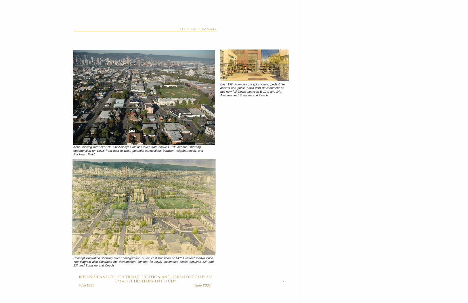
East 13th Avenue concept showing pedestrianaccess and public plaza with development ontwo new full blocks between E 12th and 14thAvenues and Burnside and Couch.
Concept illustration showing street configuration at the east transition of 14th/Burnside/Sandy/Couch.The diagram also illustrates the development concept for newly assembled blocks between 12th and13th and Burnside and Couch.
Aerial looking west over NE 14th/Sandy/Burnside/Couch from above E 18th Avenue, showingopportunities for views from east to west, potential connections between neighborhoods, andBuckman Field.
EXECUTIVE SUMMARY

8BURNSIDE AND COUCH transportation and urban design plan
CATALYST DEVELOPMENT STUDY Final Draft June 2005
LOWER/CENTRAL WEST BURNSIDE AND COUCH
The Lower/Central West Burnside and Couch segment has greater pressure todevelop and at higher densities. In addition, the proposed transportation and urbandesign improvements will certainly enhance the image of the area. Theimprovements include wider sidewalks for improved pedestrian access, increasedauto access, and additional parking. This segment also has numerous challenges tocatalyze surrounding development and provide balance within this area of the CentralCity. These challenges include:
• No major short-term interest in redevelopment from existing areaproperty owners
• Numerous historic properties, many with possible seismic upgradeconcerns
• Existing underdeveloped properties that are income generating(primarily surface parking lots)
• Problems assembling large parcels of land and diverse propertyownership
Given these development challenges and current lack of redevelopment interest, newdevelopment will likely occur in 10 to 15 years - a longer time frame compared to theeast segment.
EXECUTIVE SUMMARY

BURNSIDE AND COUCH transportation and urban design planCATALYST DEVELOPMENT STUDY
Final Draft June 20059
Lower West Burnside and Couch looking northeast from SW 2nd Avenue.
Concept illustration looking southeast over West 4th Avenue, Burnside and Couch showingredevelopment opportunities and proposed right-of-way improvements.
EXECUTIVE SUMMARY

10BURNSIDE AND COUCH transportation and urban design plan
CATALYST DEVELOPMENT STUDY Final Draft June 2005
UPPER WEST BURNSIDE
Upper West Burnside is a dynamic segment poised for redevelopment due to itsproximity to downtown as well as Portland Heights, Kings Heights, and WillametteHeights, all affluent urban neighborhoods. The adjacent Pearl District and NWPortland, to the east and north respectively, also place strong pressure for continualupgrade of property. Currently, however, there are few redevelopment sites; manyunderdeveloped businesses on these sites have recently changed hands or beenrenovated and are operating successfully.
Upper West Burnside, looking westfrom 15thAvenue with existing CivicApartments site in the upper right.
Proposed Civic Redevelopment looking south from NW 18th andBurnside with mixed housing and ground floor retail.
SE
RA
Arc
hite
cts
EXECUTIVE SUMMARY

BURNSIDE AND COUCH transportation and urban design planCATALYST DEVELOPMENT STUDY
Final Draft June 200511
NEXT STEPS
The study’s recommended next steps are contingent on actions taken on the Burn-side Transportation and Urban Design Plan Technical Refinements. In addition,funding availability for the Burnside Couch Transportation and Urban Design Plan’sproposed improvements will help determine budget availability policy direction oncatalyst development. Given those qualifications, the study’s next steps include:
TASK RESPONSIBLE PARTY LOWER EAST BURNSIDE AND COUCH As part of the Central Eastside Urban Renewal Study, consider possible inclusion of some or all of catalyst development site at E Burnside/Couch/ Sandy/14th.
PDC
LOWER/CENTRAL WEST BURNSIDE AND COUCH Determine priority of implementing catalyst development at W Burnside/Couch/4th/5th given other Downtown Waterfront Urban Renewal Area projects.
PDC, OTCT and other neighborhood groups
If project is determined a priority, then: Determine funding availability for catalyst development.
PDC, OTCT and other neighborhood groups
Pursue predevelopment work on catalyst development site at W Burnside/Couch/4th/5th to include:
- Perform public outreach to help determine redevelopment priorities.
- Work with property owners to redevelop properties on Blocks 1, 2, 4 and 5, with priority given to the Grove Hotel.
- Coordinate with owners of Blocks 1 and 2 to develop long and short term redevelopment goals.
- Research potential developers for private investment.
- Study ways to provide for more active ground floor uses.
PDC
Work with the Old Town/Chinatown neighborhood to consider other efforts to revitalize the Burnside/Couch corridor—possibly through the development of housing, social services, or retail strategies.
PDC
Promote private sector development on catalyst development site.
Friends of Burnside/Couch
EXECUTIVE SUMMARY
LEGEND
PDC Portland Development CommissionOTCT OldTown/China Town

12BURNSIDE AND COUCH transportation and urban design plan
CATALYST DEVELOPMENT STUDY Final Draft June 2005

BURNSIDE AND COUCH transportation and urban design planCATALYST DEVELOPMENT STUDY
Final Draft June 200513
CATALYST DEVELOPMENTSTUDY
INTRODUCTION
BACKGROUND
The Burnside Transportation and Urban Design Plan, adopted in December 2002 byCity Council, provides a vision and strategy for humanizing Burnside from E 14th
Avenue to W 24th Place and transforming one of the city’s most blighted areas into avital urban pedestrian environment. The creation of the Burnside/Couch couplettogether with street and sidewalk improvements are designed to make it morecomfortable for pedestrians to cross Burnside, unite properties to the north and southof Burnside, generate more active ground floor uses, and stimulate development atkey opportunity sites along the corridor. This will make the corridor a desirable placeto walk, congregate, work, live, and play. Specific improvements include:
• Realignment of Burnside and Couch into a one-way couplet systembetween E 14th and W 16th Avenues. (Burnside Street eastbound andCouch Street westbound)
• Vehicular left turns at most intersections from W 14th to E 14thAvenues.
• Traffic signal and curb extensions at intersections.• Narrowed pedestrian crossing distance across Burnside and wider
sidewalks.• An extensive parallel bike route on Flanders and increased bike lanes
on W Burnside.• New and increased full-time parking spaces on Burnside.• A unique parking configuration in the Central City segment of
Burnside that has the opportunity to be used for a flexible publicspace.
While completing right-of-way improvements would undoubtedly create a morepleasant environment, another purpose of the plan is to leverage public right-of-wayimprovements to stimulate redevelopment along the entire corridor and transform whatis now perceived as a “barrier” into a thriving boulevard. With significantly improvedaccess and qualitative improvements, the 2002 plan’s recommended Burnside andCouch couplet anticipated leveraging approximately $500 million of potential newdevelopment. The plan’s implementation strategy called for a subsequent marketanalysis to better gauge development potential and financial return.
INTRODUCTION

14BURNSIDE AND COUCH transportation and urban design plan
CATALYST DEVELOPMENT STUDY Final Draft June 2005
Pursuant to this recommendation, the Burnside and Couch Transportation and UrbanDesign Plan Phase II Catalyst Development Study demonstrates the plan’s marketpotential, economic return on capital investment, and value added to the localcommunity over the next 20 years. The study is also a companion document to theBurnside Transportation and Urban Design Plan Technical Refinements, a moredetailed update of the first phase urban design scheme.
GOALS
The goals of the study are to:
• Determine private development interest that might result fromproposed capital improvements
• Analyze development potential of future catalyst sites and study area• Calculate the economic impact of capital investment and catalyst
development on property assessed value within the study area.
STUDY AREA
Building on the project area of the Burnside/Couch urban design plans, this studyarea is generally bounded by Davis Street on the north, Ankeny and Ash Streets onthe south, E 14th Avenue on the east, and W 24th Place on the west (seeaccompanying study area map). Three catalyst development sites were selected forconsideration within this area:
• Site 1. E 12th/Sandy/Burnside/Couch• Site 2. E 3rd/Burnside/Couch• Site 3. W 4th/Burnside/Couch/Ankeny
These sites were selected based on the following criteria:
• Potential from redevelopment on contiguous blocks to providecatalyst effect on underdeveloped surrounding blocks
• Street reconfiguration may contribute to increased developable landarea
• Blighted area in need of improvements
METHODOLOGY
The potential development and economic return on capital investment in transportationand urban design improvements was calculated using the following methodology:
1. Determine and aggregate development and feasibility programs forthe catalyst opportunity sites by preparing likely redevelopmentprograms, massing, cost, and financial feasibility.
INTRODUCTION

BURNSIDE AND COUCH transportation and urban design planCATALYST DEVELOPMENT STUDY
Final Draft June 200515
The development potential of Site 2 at E 3rd/Burnside/Couch waspreviously examined as part of the Lower East Burnside Mixed-UseOpportunity Development Study; that analysis is incorporated in thisstudy. A detailed development potential and feasibility analysis for Site1 at E 12th/Sandy/Burnside/Couch, and Site 3 at W 4th/Burnside/Couch/Ankeny, was completed as part of this study.
2. Prepare a trend analysis to model the incremental increase in studyarea taxable property value (Maximum Assessed Value or MAV) andproperty taxes, assuming transportation, streetscape and urban designimprovements with catalyst development over time.1
The trending analysis used to estimate the incremental addition totaxable property value was completed by dividing the study area intothree distinct segments:
• Lower East Burnside and Couch: from E 14th Avenue to the E Burnside bridgehead• Lower/Central West Burnside and Couch: from the W Burnside bridgehead to W 15th Avenue• Upper West Burnside: from W 15th Avenue to W 24th Place
The incremental increase in taxable property value over a 20-year analysisperiod was calculated as the difference between what the trended MAV wouldbe if the project (including transportation and urban design improvements andcatalyst development) moves forward as envisioned compared to a baselinetrending of MAV without the project. In other words, catalyst development atSites 1, 2, and 3 was included only in the “with project” trend.2 Year 1 wasassumed to occur in 2005. In addition, cost inflation was assumed at 3% andthe assumed assessed value ratio was 60%.
1 In Oregon, a property’s Maximum Assessed Value (MAV) is limited by Tax Measures 5, 47and 50 to a 3% growth per annum over the previous year’s assessed value. However, aproperty’s MAV can increase at a faster rate if capital additions are made.
2 Two other projects, at W 1st/Burnside/Ash and W 19th/Burnside, were also considered tohave significant impact on area development and were, therefore, incorporated into both thebaseline and “with project” trends. The project at W 1st/Burnside/Ash is part of the PDC/Citysponsored downtown waterfront redevelopment and is assumed to be completed in Year10. The project at W 19th/Burnside is the Civic Apartments redevelopment by Gerding EdlenDevelopment Co. and the Housing Authority of Portland, assumed to be completed in Year 1.
INTRODUCTION

16BURNSIDE AND COUCH transportation and urban design plan
CATALYST DEVELOPMENT STUDY Final Draft June 2005
LEGEND
Catalyst Development Areas
Project ContextStreetCrosswalkProject AreaVehicular Traffic FlowTraffic SignalStreet Tree
CATALYST DEVELOPMENT STUDY
TRANSPORTATION AND URBAN DESIGN PLAN TECHNICAL REFINEMENTS
• Eastbound Burnside traffic on Burnside becomes one-way eastbound at 16th Avenue• Transition westbound Couch to Burnside at 15th Avenue• Close Couch between 15th Avenue and 16th Avenue:
- Preserve bicycle and pedestrian access- Realign 16th Avenue north of Burnside to connect to 16th Avenue south of Burnside- Convert 16th Avenue south of Burnside to two-way operation- Rebuild curb extensions at all intersections- Infill street trees and ornamental street lights
• Convert Couch to two one-way westbound lanes at 2nd Avenue:- Traffic signals at every intersection- Preserve on-street parking, existing sidewalks, healthy existing street trees
• Convert West 2nd between Burnside and Couch to three one-way northbound lanes,remove on-street parking on the east side of the street.
• Provide angled parking on west side NW 2nd north of Couch• Transition westbound Burnside bridge traffic to Couch at 2nd Avenue• Convert eastbound on Burnside to:
- Four lanes from West 4th Avenue to 2nd Avenue- Three through lanes from 3rd Avenue across the bridge to the east side- Add left-turn only lane from 3rd Avenue to 2nd Avenue providing left turn to 2nd Avenue- Full time on-street parking south side, full time north side parking in flexible plaza space- Striped bike lane (east of 4th Avenue) and wider sidewalks- Rebuild substandard sidewalks
• Provide traffic signals at every intersection from 1st Avenue to 16th Avenue• Install signals at every intersection on Burnside and Couch
• Reconfigure two-way Burnside from 16th Avenue to 23rd Avenue with:- Four 10-foot travel lanes- Ten-foot wide sidewalks- Ornamental street lights and street trees
• Reconfigure 18th /19th /Burnside/Alder intersection• Reconfigure 20th Place intersection and add parking• Add new signals at 20th Place and 22nd Avenue
SITE 3
DEVELOPMENT PROGRAM
Housing 350 UnitsOffice 395,000 SFRetail 87,800 SFCommunity Service 10,300 SFHotel 230 RoomsParking 934 SpacesJobs 1,450 Jobs
Development Cost 225 MillionPublic InvestmentRequirement/”Gap” 10 Million
CENTRAL WEST BURNSIDE AND COUCHUPPER WEST BURNSIDE

BURNSIDE AND COUCH transportation and urban design planCATALYST DEVELOPMENT STUDY
Final Draft June 200517
• Close Sandy between NE 14th and NE 12th Avenues• Convert Burnside to three and four lanes, one-way eastbound with full
time on-street parking, striped bike lane, wider sidewalks, preserve existingstreet trees and street lighting
• Convert Couch to two lanes, one-way westbound,- Preserve on-street parking, existing sidewalks and healthy existing street trees- Rebuild substandard sidewalks- Provide curb extensions at all intersections- Infill street trees and ornamental street lights
• Convert NE 14th to three lanes, one-way northbound, remove on-street parking• Preserve the NE 13th right-of-way with two-way movement• Realign NE 12th to include four lanes (two southbound, two north
bound), two striped bike lanes and on-street parking on the east side of theright-of-way
• Install signals at every intersection on Burnside and Couch.• Enlarge pedestrian island at 12th/Sandy/Burnside• Install new signals on Burnside and Couch at NE 14th , NE 13th and
NE 12th Avenues• Install a new signal on NE 12th and NE Davis• Provide diagonal parking on Couch east of NE 14th Avenue• Transition west end of couplet at NE 3rd Avenue• Maintain NE 3rd Avenue as a two-way street
SITE 2
DEVELOPMENT PROGRAM
Housing 380 UnitsOffice 207,000 SFRetail 246,000 SFParking 775 SpacesJobs 995 Jobs
Development Cost 147 MillionPublic Investment”Gap” 8 Million
SITE 1
DEVELOPMENT PROGRAM
Housing 330 UnitsOffice 204,000 SFRetail 160,000 SFIndustrial 35,000 SFParking 1,200 SpacesJobs 8855 Jobs
Development Cost 140 MillionPublic Investment”Gap” 21 Million
LOWER EAST BURNSIDE AND COUCH
DEVELOPMENT/PUBLIC INVESTMENT COST
SITE DEVELOPMENT PUBLIC
COST INVESTMENT
Site 1 140 M 21 MSite 2 147 M 8 MSite 3 225 M 10 M
Total Public Investment 39 M
TRANSPORTATION/STREETSCAPE COSTS
Upper West Burnside 8.5 MLower/Central 17 MLower East 16 MFlanders Bike Improvements 3.5 M
Total 45 M

18BURNSIDE AND COUCH transportation and urban design plan
CATALYST DEVELOPMENT STUDY Final Draft June 2005
East Burnside looking east from 12th/Sandy/Burnside.
NE 3rd Avenue looking south under the Burnside Bridge. View looking west toward the 7-Up bottling company at 12th/Sandy/Burnsideand Couch intersection.
EXISTING CONDITIONS
BURNSIDE AND COUCH transportation and urban design planCATALYST DEVELOPMENT STUDY
Final Draft June 200519
EXISTING CONDITIONSBurnside is at the center of Portland and the metropolitan region. It is the mostprominent east/west street in the city in that it stretches continuously from thefoothills of Mt. Hood to the valleys of Washington County. Burnside is historically,culturally and economically rich with industry, commerce, services andneighborhoods.
Aside from the recently completed Brewery Blocks and 8 NW 8th projects and astring of renovations along East Burnside; Burnside and Couch have manyopportunities for new development on surface parking lots or redevelopment of smallerone- and two-story buildings.
While there are numerous late 19th and early 20th century commercial and residentialbuildings along both streets, much of the architecture is of the 1950s and 1960s.
LOWER EAST BURNSIDE AND COUCH
Lower East Burnside and Couch is a seam of commercial and residential propertiesbetween general industrial uses reaching from east 14th to I-5 and the WillametteRiver. To the north is Franz Bakery and a variety of wholesale and service businessesthat supply the Central City and the region. To the south are additional servicebusinesses as well as a large concentration of building supply companies rangingfrom furniture to raw construction materials. Much of the property is within the CentralEastside industrial sanctuary that protects industrial uses while restricting retail andprohibiting residential uses. In general, properties between Couch and Ankeny from2nd to 12th Avenue are zoned Central Employment (EXd) which allows a broad rangeof commercial, retail and residential uses.
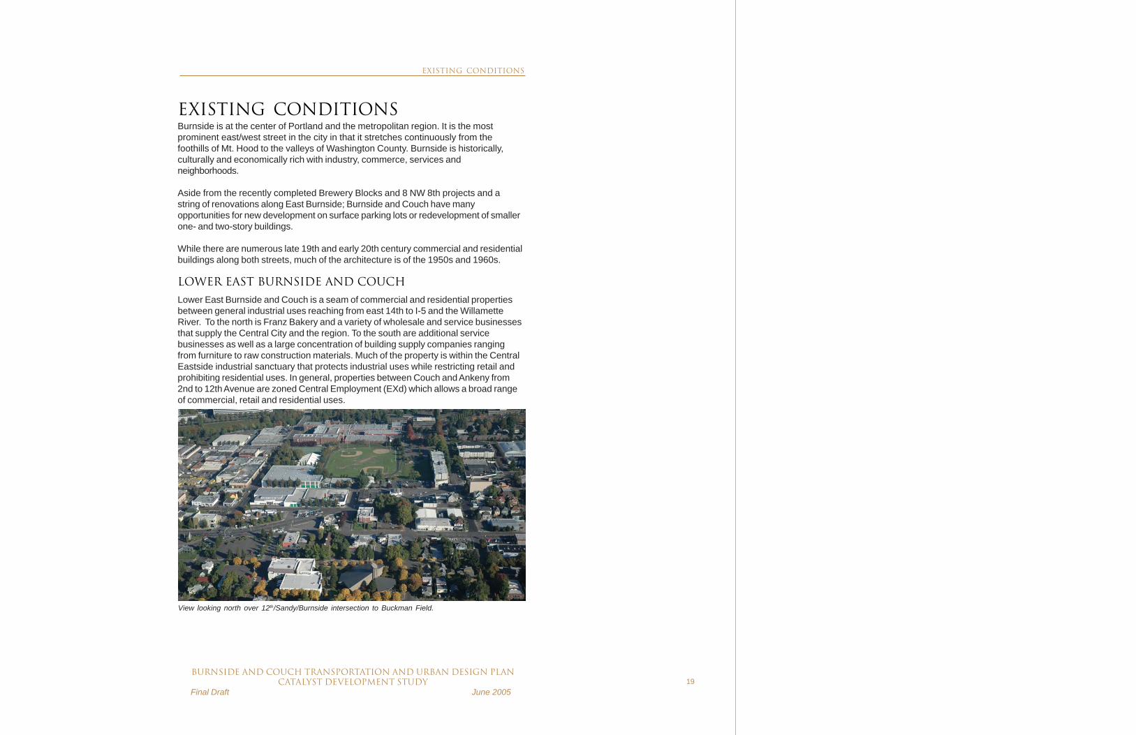
View looking north over 12th/Sandy/Burnside intersection to Buckman Field.
EXISTING CONDITIONS

20BURNSIDE AND COUCH transportation and urban design plan
CATALYST DEVELOPMENT STUDY Final Draft June 2005
Burnside looking north at SW 4th Avenue.
Long pedestrian crossings, narrow sidewalks, lack of left turns and no on-street parking contribute to the “Burnside barrier”. This view is ofBurnside looking southeast from NE 4th Avenue.
Sidewalks are undersized for the scale of Burnside. Building owners have closed off windows and avoid on-street uses such as café tables andsidewalk sales.
The existing Burnside barrier is created by long pedestrian crossings, narrow sidewalks, and lack of left turns and on-street parking.
Burnside looking north at NE 3rd Avenue. The Brewery Blocks at NE 10th and Couch.
EXISTING CONDITIONS

BURNSIDE AND COUCH transportation and urban design planCATALYST DEVELOPMENT STUDY
Final Draft June 200521
LOWER/CENTRAL WEST BURNSIDE AND COUCH
Lower/Central West Burnside and Couch is located between dense commercial andretail uses. To the south is Portland’s central core and the West End. The centralcore contains the highest density development in Oregon with building heightspeaking at 460 feet with floor area ratios (FAR) as high as 15:1.
Some of the highest density development standards front Burnside and Couch. Southof Burnside and east of Park Avenue is Portland’s financial district and “hotel row” onBroadway. West of Park Avenue is the West End where newer developments areplanned to infill among older brick and concrete buildings. There are numeroussurface parking lots scattered throughout the area.
At the east end of Lower/Central West Burnside and Couch is the Old Town/Chinatown neighborhood, where a mix of 19th and early 20th century buildings arewithin the designated New Chinatown/Japantown and Skidmore Fountain/Old TownHistoric Districts. Many of the older buildings are contributing properties in thehistoric districts, and many are also individually listed in the National Register ofHistoric Places. Some contributing buildings are eligible for individual listing, but notcurrently designated as such. The historic buildings also provide single-roomoccupancy or affordable retirement housing.
Lower West Burnside and Couch looking northeast from SW 2nd Avenue.
EXISTING CONDITIONS

22BURNSIDE AND COUCH transportation and urban design plan
CATALYST DEVELOPMENT STUDY Final Draft June 2005
This area has the highest concentration of social services and affordable housingproviders in the metropolitan area. While street life on Burnside and Couch is out ofbalance with other parts of the Central City—homeless individuals sleeping in publicplaces, drug dealing, prostitution and a small transient population—local serviceproviders and businesses have made a significant effort to provide intervention andfunding to abate these activities. Collectively, social service organizations aredeveloping facilities that encourage internal queuing through self-contained servicesfacilities, such as 8 NW 8th Avenue and the Pacific Tower, and provide holisticprograms to help people to become self-sufficient.
Lower/Central West Burnside also features the most extensive and diverseentertainment and night life district in Oregon. There are over 100 restaurants, barsand night clubs within easy walking distance. These range from low-end burlesqueand dance clubs to high-end dining. Five performance venues, including the CrystalBall Room, Roseland Theater, Oregon Ballet Theater, and the Paris and Star Theaters,make Burnside and Couch a lively and diverse performing arts district. However, it iswidely acknowledged that Burnside poses a significant barrier to drawing downtownbusiness employees north into Oldtown/China Town for lunch and daytime activities.Narrowing and improving the public right-of-way and stimulating multiblockredevelopment would likely unlock business potential and revitalize this area of theCentral City.
Today, eastbound traffic on Burnside has onlytwo left turn opportunities within the Lower WestBurnside segment. The first opportunity is at 8thAvenue via Ankeny and Broadway. The secondis at 3rd Avenue via Ash and 4th Avenue. If thesetwo turning opportunities are missed, thenvehicles must cross the Burnside Bridge to eastPortland and make a similar multiblock turningmovement to recross the bridge to turn north intoOld Town/Chinatown. This same required out ofdirection movement is found in the Lower EastBurnside Couch segment where access to theCentral Eastside District and I-84 is circuitousand confusing which compromises truck andautomobile access.
Burnside
CouchBroadw
ay
NW 5
th
NW 3r
d
Ankeny
NW 4
th
NW 8
th
NW 6
th
SW Ash
From Downtown, Burnside poses a significantbarrier to the many restaurants andentertainment venues in the Lower/CentralBurnside and Couch area.
EXISTING CONDITIONS

BURNSIDE AND COUCH transportation and urban design planCATALYST DEVELOPMENT STUDY
Final Draft June 200523
To the north and west of Park Avenue is the south edge of the Pearl District and therecently completed five-block Brewery Blocks redevelopment. The Brewery Blockshave catalyzed new renovation projects south of Burnside. While the Brewery Blocksoffer a significant increase in high-end and market rate downtown housing, a numberof affordable housing buildings are clustered along the Bill Roberts Transit Mall.
Central City Concern’s 8 NW 8thdevelopmentoffers both housing and social services.
Brewery Blocks development at W Burnside andNW 10th Avenue.
EXISTING CONDITIONS

24BURNSIDE AND COUCH transportation and urban design plan
CATALYST DEVELOPMENT STUDY Final Draft June 2005
UPPER WEST BURNSIDE
The Upper West Burnside is bordered by primarily commercial and retail uses as wellas high density historic apartment buildings built in the late 19th and early 20thcenturies. To the north and south are some of Portland’s most affluent neighbor-hoods, including Portland Heights, Kings Heights, and Willamette Heights.
View of Upper West Burnside looking west from West 15th Avenue and I-405.
EXISTING CONDITIONS

BURNSIDE AND COUCH transportation and urban design planCATALYST DEVELOPMENT STUDY
Final Draft June 200525
URBAN RENEWAL
The study area is within three urban renewal areas including the Central Eastside,Downtown Waterfront and River Districts. The study area abuts the South ParkBlocks Urban Renewal Area along W Burnside from 9th to 15th Avenues. The por-tions of the study area that are outside urban renewal areas include the blocksbetween E 12th and E 14th Avenues and Upper West Burnside from I-405 to NW 24th
Place.
Urban renewal has played a vital role along and near Burnside and Couch, includingsuch projects as the Brewery Blocks and 8 NW 8th development projects,improvements to 3rd and 4th Avenues in Old Town/Chinatown, and the construction ofthe Chinese Classical Garden at NW Everett and 4th.
ZONING
Typically, the zoning within the study area and specifically within the catalyst develop-ment sites is Central Commercial (CXd) and Central Employment (EXd), the mostflexible of anywhere in the city. This zoning allows a broad range of commercial, retail,industrial and residential uses mixed in a single project.
Current zoning map of Burnside from E 15th Avenue to W 12th Avenue.
EXISTING CONDITIONS

26BURNSIDE AND COUCH transportation and urban design plan
CATALYST DEVELOPMENT STUDY Final Draft June 2005
DEVELOPMENT ADVANTAGESBurnside and Couch are at the center of the transportation, financial, retail and residen-tial heart of the metropolitan region. The following outlines the competitive advantagesof catalyst development within the study area:
• Easy access to Interstate Highways 5, 84, 405 and 26, significantlyimproved access to I-84 and I-405 with the Burnside Transportationand Urban Design Plan urban design and streetscape improvements
• High concentration of public transit, including TriMet bus and MAXservices, and the Portland Streetcar and plans to expand light railservice on the mall and streetcar on the eastside by the end of thisdecade.
• Diverse housing stock• Plentiful restaurants, entertainment and shopping within walking
distance• Nearby wholesale sales and distribution companies• Access to a variety of public open spaces including Waterfront Park,
the Eastbank Esplanade, and the Springwater Corridor trail system• Competitive land values• Incentive programs for new development and redevelopment projects
Roseland Theater and transit mall onNW 6th Avenue.
One of Old Town/Chinatown’s manyneighborhood restaurants.
The North Park Blocks at the center of theLower/Central Burnside and Couch segment.
EXISTING CONDITIONS

BURNSIDE AND COUCH transportation and urban design planCATALYST DEVELOPMENT STUDY
Final Draft June 200527
DEVELOPMENT CHALLENGESToday, a number of challenges are associated with all of the catalyst developmentareas. Below are the most significant challenges facing future catalyst developmentprojects on Burnside and Couch.
• Poor access onto and off of Burnside—prohibited left turns frustrateaccess to surrounding businesses and properties.
• Burnside’s barrier in the Lower/Central West Burnside and Coucharea continues to turn away potential downtown shoppers, diners andbusiness clientele from traveling north of Burnside.
• A larger than average indigent population, concentrated drug dealing,and higher than average crime rate.
• Large quantity of low income single-room occupancy (SRO) proper-ties, some of which are not supported by social services.
• A large concentration of social service providers, although newprojects and programs are changing the image and improving deliveryof social services.
• Historic properties that require preservation and may limit redevelop-ment potential given seismic concerns and the City’s currentlyadopted demolition review policy.
• Multiple small parcels in single ownership that potentially slow landassembly.
Such development challenges, especially in the Lower/Central West Burnside andCouch segment, suggest that while some development may occur at market rate andwith an acceptable return, multi-block development at the catalyst sites will likelyrequire some level of financial assistance. As with most catalyst projects in theCentral City (Brewery Blocks, Hoyt Street Yards, South Waterfront, Pioneer Place,and RiverPlace), a strong public/private partnership will be a necessary component toplanning and funding catalyst development along Burnside and Couch.
To determine financial assistance required and understand the impact of the capitalimprovements on study area MAV, a trend analysis was completed comparing theaverage growth in taxable property values over a 20 year period both with and withoutthe proposed development and capital improvements. This analysis provides anestimate of financial return on public investment through taxable property value andtax growth.
Parts of Couch experience suffer from lack ofbalanced street activity.
Burnside is a barrier between theneighborhoods and districts on its north andsouth sides. Lack of parking, limited turns, 4 to6 lanes of traffic and prohibited pedestriancrossing locations all contribute to the challengeof humanizing Burnside.
Lines outside of social service agencies limitother uses. Some organizations that provideshelter, food and clinical services are creatingindoor queuing and waiting areas.
EXISTING CONDITIONS

28BURNSIDE AND COUCH transportation and urban design plan
CATALYST DEVELOPMENT STUDY Final Draft June 2005

BURNSIDE AND COUCH transportation and urban design planCATALYST DEVELOPMENT STUDY
Final Draft June 200529
Concept illustration showing street configuration at the east transition of 14th/Burnside/Sandy/Couch.The diagram also illustrates the development concept for newly assembled blocks between 12th and13th and Burnside and Couch.
CATALYST DEVELOPMENT SITES
LOWER EAST BURNSIDE AND COUCH
E 14TH AVENUE TO THE E BURNSIDE BRIDGEHEAD
The Lower East Burnside and Couch project segment analysis is dependent ontransportation and urban design improvements along E Burnside and Couch from E14th Avenue to the east Burnside Bridge bridgehead, including the couplet redesign,additional bike lanes, and improved street signalization, as well as catalyst develop-ment at the following two sites:
SITE 1. E 12TH/SANDY/BURNSIDE
CATALYST DEVELOPMENT SITES

30BURNSIDE AND COUCH transportation and urban design plan
CATALYST DEVELOPMENT STUDY Final Draft June 2005
SITE 1 Development Program Housing 330 units Office 204,000 SF Retail 160,000 SF Industrial 35,000 SF Parking 1,200 spaces Development Cost $140 M Public Investment Requirement $21.1 M
Artist’s rendering of the historic 7-Up bottling plantlocated at NE 12th and NE Couch.
DESCRIPTION
The development model on this site assumes a new identity for an area currentlyunder utilized and plagued by traffic congestion at the intersection of E Burnside, 12th
Avenue, and Sandy Boulevard. The urban design framework focuses on linking theKerns and Buckman neighborhoods on the eastern and northern edges of the site bydeveloping new residential uses along Burnside and Couch while also providing amixed-industrial and commercial anchor at the eastern terminus of the proposedcouplet. A mix of condominiums and rental apartments was assumed to takeadvantage of the open space adjacent to Benson Polytechnic High School and nearbyCity tennis courts. New commercial uses including entertainment, retail and lightindustrial showrooms are sited to take full advantage of the visibility of vehicular trafficand provide support uses to the neighborhoods. This mixture of uses is bothcompatible with the existing Central Eastside and the adjacent residentialneighborhoods.
This site, located on approximately 5 city blocks, is envisioned as a major CentralCity gateway. As such, it is assumed that it would include signature architecture,gateway features and enhanced pedestrian streetscapes and paths connecting the
various uses. The landmark ArtDeco 7-Up building would berestored and redeveloped. Todetermine the economic impact ofthis catalyst development site, it isassumed this project will becomplete in Year 5.
Full development of the site cannotoccur without the assemblage of twoproperties and right-of-way createdby the couplet conversion and
subsequent vacation of Sandy Boulevard through the site.
The site area is not currently within an urban renewal area; therefore, no fundingmechanism is in place to provide the public investment required for the project.Assuming no public investment, the market would most likely deliver a more modestdevelopment program than what is analyzed in this study.
CATALYST DEVELOPMENT SITES

BURNSIDE AND COUCH transportation and urban design planCATALYST DEVELOPMENT STUDY
Final Draft June 200531
ZONING
The following map and tables show zoning, allowed uses and development standardsfor the 12th/Sandy/Burnside future catalyst development site. Note that the proposedpotential development for Blocks 1 and 3 include 100’ buildings. This developmentwould require an adjustment to the current zoning regulations which have a 65’ heightlimit for EX zoned areas.
A-1 12TH /SANDY/BURNSIDE
DEVELOPMENT STANDARD EXdj CS [1] Maximum FAR 3 to 1 3 to 1 [2] Maximum Height 65 ft. 45 ft. Minimum Building Setbacks • Street lot line • Lot line abutting an OS, C, E or I zoned lot • Lot line abutting an R zoned lot
0 0 0-14 ft. [2], [4]
0 0 0 to 14 ft. [4], [9]
Maximum Building Setbacks • Transit Street or Pedestrian District
10 ft.
10 ft. [5] [6]
Maximum Building Coverage 100% of site area Minimum of 50% of site area
Minimum Landscaped Area None None Ground Floor Window Standards apply No Yes Pedestrian Standards Apply Yes Yes Minimum Landscaping Abutting an R zoned lot 5 ft. @ L3 [3] 5 ft @ L3 [7] Exdj DEVELOPMENT STANDARDS NOTES: [2] See Table 140-4. [3] For building setbacks of 5 feet or less, landscaping is required for the entire depth of the setback. However, no landscaping is required when buildings abut a lot line. [4] No setbacks are required from an internal lot line that is also a zoning line on sites with split zoning. See 33.140.215.B.3.b CS DEVELOPMENT STANDARDS NOTES: [2] The FAR limits apply to nonresidential development. Additional floor area is allowed for residential development. See 33.130.250 and 33.130.253. [4] See Table 130-4. [5] At least 50 percent of the length of the ground level street-facing façade of buildings must be within 10 feet of the street lot line. If the site has three or more block frontages, this standard only applies to two frontages. [6] For buildings where all of the floor area is in residential use, the street-facing façade of an open porch that meets the standards of 33.130.215.B.1.a (3) is included as part of the ground level, street-facing façade of the building. [7] Does not apply to lot lines that abut a lot in the RX zone. Landscaping is not required where buildings abut a lot line. [9] No setbacks are required from an internal lot line that is also a zoning line on sites with split zoning. See 33.130.215.B.2.b. Note that the proposed potential development for Blocks 1 and 3 include 100’ build-ings. This development would require an adjustment to the current zoning regulationswhich have a 65’ height limit for EX zoned areas. The difference between analysisand existing was not figured and would depend on lower gap and lower cost.
CATALYST DEVELOPMENT SITES

32BURNSIDE AND COUCH transportation and urban design plan
CATALYST DEVELOPMENT STUDY Final Draft June 2005
Typical Upper Floor Plan.
Site 1 Ground Floor Plan looking north showing retail, entertainment, light industrial and health club uses.
TYPICAL DETAILS SITE 1: EAST 12TH/SANDY/BURNSIDE/COUCH
LEGEND
CATALYST DEVELOPMENT SITE 1
Block 1 Health Club/Housing/Above Grade ParkingBlock 2 Entertainment & Retail/Flex-Office/Housing/Below Grade ParkingBlock 3 Retail/Flex-Office/Above Grade ParkingBlock 4 Light Industrial/Flex-Office
CATALYST DEVELOPMENT: LOWER EAST BURNSIDE SITE 1
BURNSIDE AND COUCH transportation and urban design planCATALYST DEVELOPMENT STUDY
Final Draft June 200533
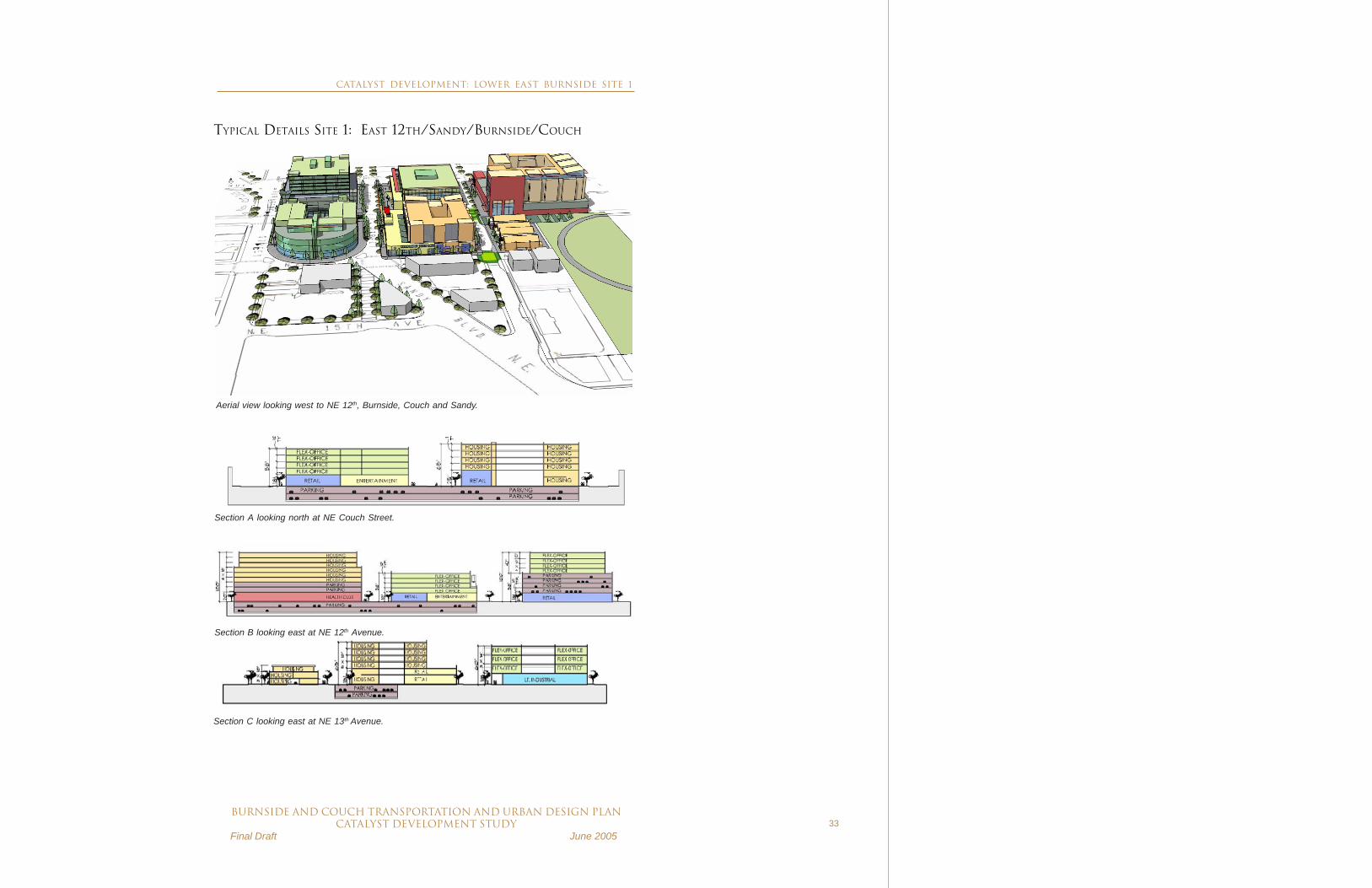
Aerial view looking west to NE 12th, Burnside, Couch and Sandy.
Section B looking east at NE 12th Avenue.
TYPICAL DETAILS SITE 1: EAST 12TH/SANDY/BURNSIDE/COUCH
Section A looking north at NE Couch Street.
Section C looking east at NE 13th Avenue.
CATALYST DEVELOPMENT: LOWER EAST BURNSIDE SITE 1

34BURNSIDE AND COUCH transportation and urban design plan
CATALYST DEVELOPMENT STUDY Final Draft June 2005
SITE 2 Development Program Housing 380 units Office 207,000 SF Retail 246,000 SF Parking 775 spaces Development Cost $146.9 M Public Investment Requirement $8.2 M
SITE 2. EAST 3RD/BURNSIDE/COUCH
DESCRIPTION
This project, commonly called the Burnside Bridgehead Mixed Use RedevelopmentProject, is sponsored by the Portland Development Commission (PDC) and hasalready gone through PDC’s Request for Proposals process. At the time of this study,a developer had not yet been selected. The development program and financialanalysis included here is derived from a previous PDC study entitled Lower EastBurnside Mixed-Use Opportunity Development dated October 2003. The proposeddevelopment program requires Burnside Transportation and Urban Design Plantransportation improvements, including the couplet conversion, as necessary forproper access to the development site. To determine the economic impact of thiscatalyst development, it is assumed this project will be complete in Year 5.
The site is located just east of theWillamette River and adjacent tothe Burnside Bridge, and canprovide a significant gateway tothe Central City and the CentralEastside. New developmenttakes advantage of views of theriver, downtown and Mt. Hood. Aredevelopment site of this size,including a 128,900 SFcontiguous parcel, is rare in theCentral City and offers a unique
opportunity for new mixed-used development including retail, housing and othercommercial uses. The site, although currently under utilized, has excellentopportunities to be a catalyst for new “spin off” development along East Burnside andCouch Streets. This project anchors the western terminus of the couplet on theeastside.
The site is within the Central Eastside Urban Renewal Area, which expires as anurban renewal area in 2006. It is assumed some public investment will be necessaryto implement the project.
CATALYST DEVELOPMENT: LOWER EAST BURNSIDE SITE 2

BURNSIDE AND COUCH transportation and urban design planCATALYST DEVELOPMENT STUDY
Final Draft June 200535
Site 2 existing zoning map
ZONING
The following map summarizes zoning for the east Burnside Bridgehead area.
CATALYST DEVELOPMENT: LOWER EAST BURNSIDE SITE 2

36BURNSIDE AND COUCH transportation and urban design plan
CATALYST DEVELOPMENT STUDY Final Draft June 2005
Site 2 Ground floor plan looking north
TYPICAL DETAILS: SITE 2 EAST 3RD/BURNSIDE/COUCH
Site 2 Upper floor plan looking north
LEGEND
CATALYST DEVELOPMENT: LOWER EAST BURNSIDE SITE 2

BURNSIDE AND COUCH transportation and urban design planCATALYST DEVELOPMENT STUDY
Final Draft June 200537
Perspective looking northeast from NE 2nd Avenue and East Burnside
TYPICAL DETAILS: SITE 2 EAST 3RD/BURNSIDE/COUCH
Section A: Looking north at NE Davis
Section B: Looking north from Burnside
CATALYST DEVELOPMENT: LOWER EAST BURNSIDE SITE 2

38BURNSIDE AND COUCH transportation and urban design plan
CATALYST DEVELOPMENT STUDY Final Draft June 2005
LOWER EAST BURNSIDE AND COUCH MAV TRENDING
The MAV incremental increase for the Lower East Burnside and Couch segment ofthe study area is $300 million (see chart below), which is almost entirely due to theimpact of the two new catalyst developments on adjacent properties’ assessed value.The “without project” baseline MAV is based on the compound increase in MAV overthe past seven years and has a 1.7% average annual increase over 20 years.” Incomparison, the “with project” MAV, assuming transportation and urban designimprovements as well as development at both catalyst sites in Year 5, has an 11.8%average annual increase.
The “with project” average is based on a rate of 1.75% average annual growth which isassumed to increase 0.5% per annum beginning in Year 3 and continuing for a periodof six years. In Year 9, the rate is then assumed to decrease at 0.5% resulting fromthe face that extraordinary rates of appreciated (tied to catalyst development) areunlike to be sustained in the long-term.”
Public investment required to realize this incremental increase is approximately$16 million in transportation and urban design improvements and $29 million indevelopment investment.
CATALYST DEVELOPMENT: LOWER EAST BURNSIDE

BURNSIDE AND COUCH transportation and urban design planCATALYST DEVELOPMENT STUDY
Final Draft June 200539
LOWER/CENTRAL WEST BURNSIDE AND COUCH
W BURNSIDE BRIDGEHEAD TO W 15TH AVENUE
The Lower/Central West Burnside and Couch project segment involves extensivetransportation and urban design improvements including couplet conversion andexpanded sidewalks, additional traffic signals, curb extensions, pedestrian crossings,and on-street parking. One new catalyst development at 4th Avenue/Burnside/Couchand Ankeny is proposed within this segment.
SITE 3. W 4TH/BURNSIDE/COUCH/ANKENY
Concept illustration looking southeast over West 4th Avenue, Burnside and Couch showing redevelopment opportunities and proposed right-of-wayimprovements.
CATALYST DEVELOPMENT: LOWER /CENTRAL WEST BURNSIDE
40BURNSIDE AND COUCH transportation and urban design plan
CATALYST DEVELOPMENT STUDY Final Draft June 2005
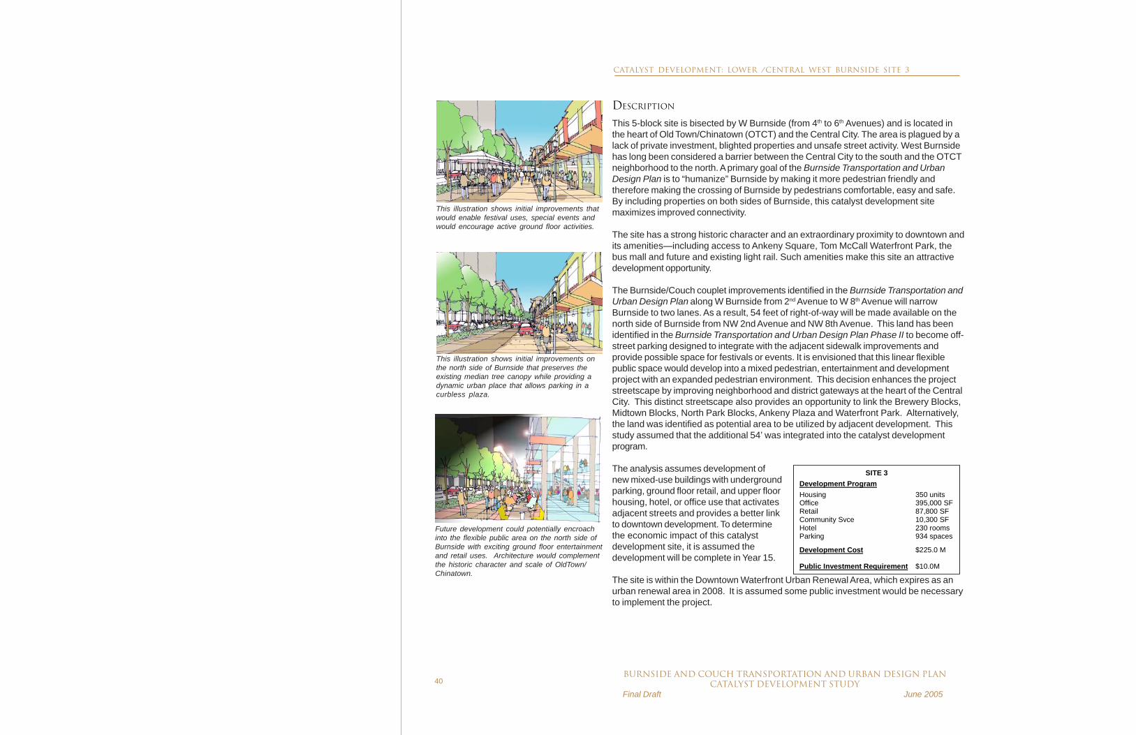
DESCRIPTION
This 5-block site is bisected by W Burnside (from 4th to 6th Avenues) and is located inthe heart of Old Town/Chinatown (OTCT) and the Central City. The area is plagued by alack of private investment, blighted properties and unsafe street activity. West Burnsidehas long been considered a barrier between the Central City to the south and the OTCTneighborhood to the north. A primary goal of the Burnside Transportation and UrbanDesign Plan is to “humanize” Burnside by making it more pedestrian friendly andtherefore making the crossing of Burnside by pedestrians comfortable, easy and safe.By including properties on both sides of Burnside, this catalyst development sitemaximizes improved connectivity.
The site has a strong historic character and an extraordinary proximity to downtown andits amenities—including access to Ankeny Square, Tom McCall Waterfront Park, thebus mall and future and existing light rail. Such amenities make this site an attractivedevelopment opportunity.
The Burnside/Couch couplet improvements identified in the Burnside Transportation andUrban Design Plan along W Burnside from 2nd Avenue to W 8th Avenue will narrowBurnside to two lanes. As a result, 54 feet of right-of-way will be made available on thenorth side of Burnside from NW 2nd Avenue and NW 8th Avenue. This land has beenidentified in the Burnside Transportation and Urban Design Plan Phase II to become off-street parking designed to integrate with the adjacent sidewalk improvements andprovide possible space for festivals or events. It is envisioned that this linear flexiblepublic space would develop into a mixed pedestrian, entertainment and developmentproject with an expanded pedestrian environment. This decision enhances the projectstreetscape by improving neighborhood and district gateways at the heart of the CentralCity. This distinct streetscape also provides an opportunity to link the Brewery Blocks,Midtown Blocks, North Park Blocks, Ankeny Plaza and Waterfront Park. Alternatively,the land was identified as potential area to be utilized by adjacent development. Thisstudy assumed that the additional 54’ was integrated into the catalyst developmentprogram.
The analysis assumes development ofnew mixed-use buildings with undergroundparking, ground floor retail, and upper floorhousing, hotel, or office use that activatesadjacent streets and provides a better linkto downtown development. To determinethe economic impact of this catalystdevelopment site, it is assumed thedevelopment will be complete in Year 15.
The site is within the Downtown Waterfront Urban Renewal Area, which expires as anurban renewal area in 2008. It is assumed some public investment would be necessaryto implement the project.
SITE 3 Development Program Housing 350 units Office 395,000 SF Retail 87,800 SF Community Svce 10,300 SF Hotel 230 rooms Parking 934 spaces Development Cost $225.0 M Public Investment Requirement $10.0M
This illustration shows initial improvements thatwould enable festival uses, special events andwould encourage active ground floor activities.
This illustration shows initial improvements onthe north side of Burnside that preserves theexisting median tree canopy while providing adynamic urban place that allows parking in acurbless plaza.
Future development could potentially encroachinto the flexible public area on the north side ofBurnside with exciting ground floor entertainmentand retail uses. Architecture would complementthe historic character and scale of OldTown/Chinatown.
CATALYST DEVELOPMENT: LOWER /CENTRAL WEST BURNSIDE SITE 3

BURNSIDE AND COUCH transportation and urban design planCATALYST DEVELOPMENT STUDY
Final Draft June 200541
ZONING
The following map summarizes zoning standards for the Lower/Central West Burnsidearea.
The assumed potential development includes the removal of three National Registerbuildings—the Grove Hotel, the Goldsmith Company, and Cindy’s—which are contrib-uting properties in the New Chinatown/Japantown Historic District. Under currentzoning regulations, the removal of these buildings would be subject to a demolitionreview process which could either approve or deny demolition of the building.
Zoning map showing commercial, employment and residential uses with a design overlay.
CATALYST DEVELOPMENT: LOWER /CENTRAL WEST BURNSIDE SITE 3

42BURNSIDE AND COUCH transportation and urban design plan
CATALYST DEVELOPMENT STUDY Final Draft June 2005
SITE 3: WEST 4TH/BURNSIDE/COUCH/ANKENY
Site 3 Ground floor plan
Site 3 Upper floor plan
CATALYST DEVELOPMENT SITE-3
Block 1 Condominium/Retail/Below Grade ParkingBlock 2 Hotel/Retail/Below Grade ParkingBlock 3 Incubator Office/Community Space/Below Grade ParkingBlock 4 Point Tower/Office/Retail/Below Grade ParkingBlock 5 Office/Retail/Below Grade Parking
LEGEND
CATALYST DEVELOPMENT: LOWER /CENTRAL WEST BURNSIDE SITE 3

BURNSIDE AND COUCH transportation and urban design planCATALYST DEVELOPMENT STUDY
Final Draft June 200543
SITE 3: WEST 4TH/BURNSIDE/COUCH/ANKENY
Section A looking north at East Burnside.
Section B looking east at SW 5th Avenue.
Aerial view looking northwestto W Burnside and 4thAvenue.
CATALYST DEVELOPMENT: LOWER /CENTRAL WEST BURNSIDE SITE 3

44BURNSIDE AND COUCH transportation and urban design plan
CATALYST DEVELOPMENT STUDY Final Draft June 2005
LOWER/CENTRAL WEST BURNSIDE AND COUCH MAVTRENDING
The taxable property value (MAV) incremental increase for the Lower/Central WestBurnside segment of the study area is $424 million (see chart below), which isprimarily due to the impact of new catalyst development on assessed property values.The baseline MAV has an estimated increase of 10.0% per annum (or 9.5% average),based on the compound increase in MAV over the past seven years. In comparison,the “with project” average increase is 11.3% per annum with catalyst developmentassumed in Year 15. Note that the proximate redevelopment project focused atAnkeny Plaza, part of the PDC/City sponsored Downtown Waterfront developmentopportunity strategy, is included in both the baseline and “with project” trend and isassumed to be completed in Year 10.
The “with project” average is based on a rate of 10.0% average annual growth which isassumed to increase 0.5% per annum beginning in Year 14 and continuing for aperiod of five years. In the sixth year, the baseline rate is decreased at 0.5% perannum. Lower/Central West Burnside has a much higher assumed baseline MAV rateof increase because of significant development pressure within this segment—including central city activity, the City’s Park Avenue Vision and related newdevelopment along the Park Blocks, as well as the recent success of the BreweryBlocks at the segment’s west end.
The public investment required to realize this increase in property assessed value isapproximately $17 million in transportation and urban design improvements and $10million in development investment.

BURNSIDE AND COUCH transportation and urban design planCATALYST DEVELOPMENT STUDY
Final Draft June 200545
UPPER WEST BURNSIDEW 16TH AVENUE TO W 24TH PLACE
The Upper West Burnside project segment and taxable property value analysisincludes basic transportation and urban design improvements as proposed in theBurnside Transportation and Urban Design Plan, such as expanded sidewalks andadditional street trees. No new catalyst development is specified as part of this study.
Proposed Civic Redevelopment looking south from NW 18th and Burnside with mixed housing
SE
RA
Arc
hite
cts
CATALYST DEVELOPMENT: UPPER WEST BURNSIDE

46BURNSIDE AND COUCH transportation and urban design plan
CATALYST DEVELOPMENT STUDY Final Draft June 2005
UPPER WEST BURNSIDE MAV TRENDING
The taxable property value or MAV trending analysis for this segment includes thecurrent proposed Civic Apartments redevelopment at 635 SW 19th Avenue in both thewith and without project scenarios. This development is considered to have animportant role in supporting adjacent right-of-way improvements, and will includeaffordable housing, condominiums, and ground floor retail. It is assumed to becompleted in Year 1.
The MAV incremental increase for the Upper West Burnside segment of the studyarea is approximately $23 million (see chart below), which is due to the impact ofright-of-way improvements on stimulating new private development and increasedassessed value. The baseline MAV has an estimated increase of 2.85% per annum(or 2.7% average), based on the compound increase in MAV over the past sevenyears. In comparison, the “with project” average increase is 3.3% per annum.
The “with project” average is based on a 2.85% average annual growth which isassumed to increase to 3.5% per annum beginning in Year 5 and continuing for theanalysis period. The assumed increase per annum is higher than the eastside due tothe fact that this segment is within a dynamic portion of West Burnside that is poisedfor redevelopment due to its proximity to the downtown core, affluent urbanneighborhoods (Portland Heights/Kings Heights/Willamette Heights), the PearlDistrict and NW Portland.
The public investment required to realize this increase in property assessed value isapproximately $8.5 million in transportation and streetscape improvements.
CATALYST DEVELOPMENT: UPPER WEST BURNSIDE
Estimated Upper West Burnside MAV Over 20 Years, With and Without Project
$0
$50,000,000
$100,000,000
$150,000,000
$200,000,000
$250,000,000
1 2 3 4 5 6 7 8 9 10 11 12 13 14 15 16 17 18 19 20
Year
MA
V
MAV Baseline
MAV w/ Project
3.3% average increase per annum.
2.7% average increase per annum.
$224,337,092
$201,552,492

BURNSIDE AND COUCH transportation and urban design planCATALYST DEVELOPMENT STUDY
Final Draft June 200547
INVESTMENT And RETURN
In total, the difference between a $2.1 billion MAV with capital improvement anddevelopment investment, and a $1.35 billion MAV without improvement or catalystdevelopment translates into an incremental increase in taxable property value ofapproximately $750,000,000 over a 20-year time frame for all three segments of thestudy area. Otherwise understood, there is an estimated average MAV growth rate of9.6% per annum with the project (see chart following). This is in comparison to anestimated average baseline MAV trend rate of 7.2% per annum if the transportationand development project does not occur.
INVESTMENT AND RETURN

48BURNSIDE AND COUCH transportation and urban design plan
CATALYST DEVELOPMENT STUDY Final Draft June 2005
A related incremental increase in property tax return results from an increased MAV:
• Using an assumed property tax rate constant of 2.2% of MAV,current property tax collections of about $5 million per year wouldincrease to $30 million per year without the project versus taxcollections of $46.5 million per year with the project
• This translates into an incremental increase of $16.5 million inproperty taxes per year in Year 20.
• In addition, there would be annual incremental taxes resulting eachprevious year from the positive impact of catalyst development andcapital improvement on property assessed value.
Public investment required to realize the Burnside Transportation and Urban DesignPlan improvements is $45 million, to be used for a broad range of right-of-wayimprovements and urban design, including making Burnside and Couch into a one-waycouplet, the addition of on-street parking, increased access and an enhancedstreetscape. Public subsidy to spur an acceleration of catalyst development relative towhat would take place without the project is approximately $39 million. The followingtable summarizes the estimated impact of public capital and development investmentand private development on the study area. It should be noted that these conclusionsare based on current market conditions and could be substantively altered byincreases in achievable lease rates and/or sales prices.
INVESTMENT AND RETURN

BURNSIDE AND COUCH transportation and urban design planCATALYST DEVELOPMENT STUDY
Final Draft June 200549
TABLE 1. NEW PHYSICAL IMPROVEMENTS SUMMARY
INVESTMENT/COST
Flanders
Bike Blvd.1 Lower East
Burnside and Couch
Lower & Central West Burnside and
Couch
Upper West Burnside
STUDY AREA (as available)
Transportation Improvements $3.5 $16 M $17 M $8.5 M $45 Million Development Investment (“Gap Funding”) $0 M $29 M $10 M $0 M $39 Million
Total Project Investment/Cost $3.5 M $45 M $27 M $8.5 M $84 Million
ECONOMIC RETURN
Lower East Burnside
and Couch Lower & Central
West Burnside and Couch
Upper West Burnside
STUDY AREA (as available)
New Net Assessed Value $300 M $425 M $25 M $750 Million
New Net Taxes in Year 202 $7 M/year $9 M/year $.5 M/ year
$16.5 Million/ Year3
(7 year payback after Year 20)
(3 year payback after Year 20)
(17 year payback after Year 20)
(6 year payback after Year 20)
NEW PHYSICAL IMPROVEMENTS Lower East Burnside and Couch Lower & Central West
Burnside and Couch STUDY AREA
(as available) Site Description Site 1
• New commercial and light industrial node at E Burnside and 14th
• Create new multi-family housing to link residential neighborhoods of Buckman and Kerns
• Improve neighborhood connection to adjacent public open space
Site 2 • Gateway development to serve
as catalyst for other redevelopment in the area
• Link the east side of the central city to Downtown Portland
• Create new mixed-use development with housing, light industrial, retail, and other commercial uses
Site 3 • Integrate new mixed-use
development with rehabilitated historic buildings.
• Improve connectivity across Burnside with high-density offices to the south and lower-density housing and retail to the north.
• Active ground floor uses to provide better link to downtown development.
Housing 710 units 350 units 1,060 units Office 411,000 SF 395,000 SF 806,000 SF Retail/Commercial 406,000 SF 87,800 SF 495,000 SF Industrial 35,000 SF 0 SF 35,000 SF Community Services 0 SF 10,300 SF 10,300 SF Hotel 0 rooms 230 rooms 230 rooms Parking 1,975 spaces 934 spaces 2,910 spaces Jobs4 1,880 jobs 1,450 jobs 3,330 jobs
1 The Flanders Bike Boulevard is not within the Catalyst Development Study area, and, therefore, the improvements were not considered as part of the MAV trending analysis. The cost is included here to maintain a consistent project cost in all Phase II documents.
2 Assumes constant property tax rate of 2.2% of Maximum Assessed Value. 3This figure reflects new net taxes in Year 20 only. In addition, there are new net taxes generated every year subsequent to catalyst development and streetscape improvements; therefore, this is a conservative payback period.
4 Job estimates based on PDC Economic Development Department ratios.
INVESTMENT AND RETURN

50BURNSIDE AND COUCH transportation and urban design plan
CATALYST DEVELOPMENT STUDY Final Draft June 2005
CONCLUSIONSThe Burnside Transportation and Urban Design Plan is a sound developmentinvestment. An estimated $45 million transportation and streetscape investmenteffectively creates a physical environment which, when coupled with about $39 millionin gap development financing, could well lead to several major catalyst projects andinfill which generates:
• New assessed value of $750 million.• Net new annual tax revenues, including $16.5 million/year additional
tax revenues in Year 20 or a 6 year payback of total project costs.• The construction of 1,060 housing units.• Accommodation of 3,330 permanent jobs.
The following are study findings regarding development potential within each analysissegment. These findings were determined, in part, from interviews with catalyst siteproperty owners.
LOWER EAST BURNSIDE AND COUCH
Catalyst development sites on the eastside, especially Site 1, are clearly linked tothe street reconfiguration as proposed in the 2002 plan and the BurnsideTransportation and Urban Design Plan Technical Refinements providing new land fordevelopment. The improvements assist the development potential of Site 2, at theeast Burnside Bridgehead, which gains improved access and circulation to existingredevelopable parcels.
Development potential is enhanced due to:• Current property values that are relatively low (compared to
Lower/Central West Burnside and Couch and downtown)• More opportunities for infill development.• Fewer impediments to development, with major parcels that are
under single ownership facilitating development efforts.
Pressure for high-density development is lower compared to downtown. Therefore,while development is expected without the transportation improvements and publicinvestment, it would likely be fairly modest.
CONCLUSIONS
BURNSIDE AND COUCH transportation and urban design planCATALYST DEVELOPMENT STUDY
Final Draft June 200551
LOWER/CENTRAL WEST BURNSIDE AND COUCH
The Lower/Central West Burnside and Couch segment has greater pressure todevelop and at higher densities. In addition, the proposed transportation and urbandesign improvements, including wider sidewalks for improved pedestrian access,increased auto access, and additional parking, will certainly improve the image of thearea. This segment also has numerous challenges to catalyze surroundingdevelopment and provide balance within this area of the Central City. Thesechallenges include:
• No major short-term interest in redevelopment from existing areaproperty owners.
• Numerous historic properties, many with possible seismic upgradeconcerns.
• Existing underdeveloped properties that are income generating(primarily surface parking lots).
• Problems assembling large parcels of land and diverse propertyownership.
Given development challenges and current lack of redevelopment interest,new development will likely occur in 10 to 15 years - a longer time framecompared to the east segment.
UPPER WEST BURNSIDE
Upper West Burnside is a dynamic portion of Burnside poised for redevelopment dueto its proximity to downtown as well as Portland Heights, Kings Heights, andWillamette Heights, all affluent urban neighborhoods. The adjacent Pearl District andNW Portland, to the east and north respectively, also place strong pressure forcontinual upgrade of property. Currently, however, there are few redevelopment sites;many underdeveloped businesses on these sites have recently changed hands orbeen renovated and continue to operate successfully.
CONCLUSIONS
52BURNSIDE AND COUCH transportation and urban design plan
CATALYST DEVELOPMENT STUDY Final Draft June 2005
NEXT STEPS
The study’s recommended next steps are contingent on actions taken on the Burn-side Transportation and Urban Design Plan Technical Refinements. In addition,funding availability for the Burnside Couch Transportation and Urban Design Plan’sproposed improvements will help determine budget availability and policy direction oncatalyst development. Given those qualifications, next steps include:
TASK RESPONSIBLE PARTY LOWER EAST BURNSIDE AND COUCH As part of the Central Eastside Urban Renewal Study, consider possible inclusion of some or all of catalyst development site at E Burnside/Couch/ Sandy/14th.
PDC
LOWER/CENTRAL WEST BURNSIDE AND COUCH Determine priority of implementing catalyst development at W Burnside/Couch/4th/5th given other Downtown Waterfront Urban Renewal Area projects.
PDC, OTCT and other neighborhood groups
If project is determined a priority, then: Determine funding availability for catalyst development.
PDC, OTCT and other neighborhood groups
Pursue predevelopment work on catalyst development site at W Burnside/Couch/4th/5th to include:
- Perform public outreach to help determine redevelopment priorities.
- Work with property owners to redevelop properties on Blocks 1, 2, 4 and 5, with priority given to the Grove Hotel.
- Coordinate with owners of Blocks 1 and 2 to develop long and short term redevelopment goals.
- Research potential developers for private investment.
- Study ways to provide for more active ground floor uses.
PDC
Work with the Old Town/Chinatown neighborhood to consider other efforts to revitalize the Burnside/Couch corridor—possibly through the development of housing, social services, or retail strategies.
PDC
Promote private sector development on catalyst development site.
Friends of Burnside/Couch
NEXT STEPS

BURNSIDE AND COUCH transportation and urban design planCATALYST DEVELOPMENT STUDY
Final Draft June 200553
APPENDIX A
Public OutreachThe Burnside and Couch Catalyst Development Study was presented to a variety ofstakeholder groups between February and May 2005, including:
• Buckman Neighborhood Association• Burnside Transportation and Urban Design Plan, Stakeholder Advisory
Committee• Central Eastside Industrial Council, Land Use Committee• Central Eastside Urban Renewal Advisory Committee• East Burnside Business Association• Friends of Burnside/Couch, Inc.• Goosehollow Foothills League• Kerns Neighborhood Association• Old Town Chinatown Neighborhood Association, Visions Committee• Pearl District Business Association• Pearl District Neighborhood Association• Portland Business Alliance:
o Central City Committeeo Marketing Committeeo Transportation Committee
• Portland Freight Committee
Presentations and briefings were made in order to inform the public of study findingsas well as collect input on modeled catalyst development sites. The following inputwas received on the development programs assumed in the study:
Site 1. East 12th/Sandy/Burnside/Couch• High-rise development could create barriers, may not benefit long-term
residents of the neighborhood due to gentrification issues (increased rentsand decreased affordability), and is out of scale and character with theneighborhood.
• New development should benefit current residents.• New development should maintain light industrial uses.• The 13th Avenue green accessway is attractive, particularly because it
precludes more then a 40,000 square foot development floor plate and theinclusion of a big box retailer.
APPENDIX
54BURNSIDE AND COUCH transportation and urban design plan
CATALYST DEVELOPMENT STUDY Final Draft June 2005
Site 3. West 4th/Burnside/Couch/Ankeny• Further research is needed to determine hotel use viability and potential
absorption rates for various proposed uses given current market conditions inthe Portland metropolitan region.
• Future development should be compatible with historic buildings in the NewChinatown/Japantown Historic District and Skidmore Fountain/Old TownHistoric District.
In addition, various stakeholders expressed that neighborhood representatives shouldbe included in the discussion if and when actual development at these sites occur.