Embed Size (px)
Citation preview

Heritage Impact Assessment: Burgoyne Bridge
Burgoyne Bridge Environmental Assessment
and Preliminary Design Study City of St. Catharines, Regional Municipality of Niagara, Ontario
Structure No.: 081220
Prepared for:
DELCAN CORPORATION
4342 Queen Street, Suite 407, Niagara Falls, ON L2E 7J7
Tel.: 905-356-7003 Fax: 905-356-7008
ASI File 10EA-385
April 2011 (Revised August 2011, January 2012)

Heritage Impact Assessment: Burgoyne Bridge
Burgoyne Bridge Environmental Assessment
and Preliminary Design Study City of St. Catharines, Regional Municipality of Niagara, Ontario
Structure No.: 081220
EXECUTIVE SUMMARY
Archaeological Services Inc. (ASI) was contracted by Delcan Corporation, Niagara Falls, to conduct a Heritage Impact Assessment for the Burgoyne Bridge in order to establish the potential cultural heritage significance of the structure and to assess impacts of the undertaking on the resource. The Burgoyne Bridge carries two lanes of Regional Road 81 (St. Paul Street West) over Twelve Mile Creek and Highway 406 in the City of St. Catharines, Ontario. The bridge is owned and maintained by the Regional Municipality of Niagara. The Burgoyne Bridge is not listed on the Ontario Heritage Bridge List, and it is not municipally listed or designated under Part IV of the Ontario Heritage Act. The Burgoyne Bridge is located immediately adjacent to the Yates Street Heritage Conservation District, located west of the north approach to the bridge, an area which is designated under Part V of the Ontario Heritage Act. Based on the results of archival research, an analysis of bridge design and construction in Ontario, field investigations and application of Regulation 9/06 of the Ontario Heritage Act, the Burgoyne Bridge was determined to retain heritage value and may be considered for municipal designation under the Ontario Heritage Act. In particular, it was determined to retain strong historical and contextual values given its location at a traditional bridging point and association with the historic development of St. Catharines, and strong design values given its bridge type, age and status as a high level bridge. Following the evaluation of potential impacts on the heritage resource (see Table 3), it was determined that Conservation Alternatives 1 – 3 are the preferred alternatives, given that no impacts are expected to the heritage resource and its identified heritage attributes, with Alternative 1 being the most preferred. The remaining conservation alternatives (4 – 9) have a range of impacts, with Alternatives 8 and 9 being the least preferred options given the level and nature of the impacts resulting from removal of the bridge. Given the identified heritage value of the Burgoyne Bridge, the following recommendation and mitigation measures should be considered and implemented:
1. Based on the results of heritage evaluation, Conservation Alternatives 1 - 3 are the preferred
alternatives, with Alternative 1 being the most preferred. As part of the selection of the preferred alternatives as part of the Environmental Assessment, a clear rationale for the proposed course of action should be documented.
2. This report should be filed with the Heritage Planning Section at the City of St. Catharines, the St.
Catharines Heritage Committee, and other local heritage stakeholders that may have an interest in this project.
3. This report should be filed with the Ministry of Tourism and Culture review and comment. 4. Should retention of the bridge be chosen as the preferred alternative (one of Conservation
Alternatives 1 – 7), the character-defining elements identified in Section 8.1 should be retained and treated sympathetically.
5. Should replacement of the bridge be chosen as the preferred alternative (Conservation
Alternative 8 or 9), two mitigation options should be considered:

Heritage Impact Assessment: Burgoyne Bridge Burgoyne Bridge Class Environmental Assessment, City of St. Catharines, Ontario Page iii
a. Replacement/removal of existing bridge and construction of a new bridge with replication of the appearance of the heritage bridge in the new design, with allowances for the use of modern materials. The character-defining elements identified in Section 8.1 should be considered for replication.
b. Replacement/removal of existing bridge and construction of a new bridge with historically
sympathetic design qualities to the heritage bridge, with allowances for the use of new technologies and materials.
c. In addition to (a) and (b), development of a commemorative strategy, such as plaquing, may
be appropriate.

Heritage Impact Assessment: Burgoyne Bridge Burgoyne Bridge Class Environmental Assessment, City of St. Catharines, Ontario Page iv
ARCHAEOLOGICAL SERVICES INC. BUILT HERITAGE AND CULTURAL LANDSCAPE PLANNING DIVISION
PROJECT PERSONNEL
Project Director: Rebecca Sciarra, MA, CAHP
Cultural Heritage Specialist Manager, Built Heritage and Cultural Landscape Planning Division
Project Manager: Lindsay Popert, MA, CAHP Cultural Heritage Specialist
Cultural Heritage Specialist:
Lindsay Popert
Archival Research Brian Narhi, MA Project Historian
Project Coordinator: Sarah Jagelewski, Hon. BA Research Archaeologist
Project Administrator:
Carol Bella, Hon. BA Research Archaeologist
Report Preparation: Lindsay Popert
Graphics Preparation: Caitlin Lacy, Hon. BA Staff Archaeologist Lindsay Popert
Report Reviewer: Rebecca Sciarra

Heritage Impact Assessment: Burgoyne Bridge Burgoyne Bridge Class Environmental Assessment, City of St. Catharines, Ontario Page v
TABLE OF CONTENTS EXECUTIVE SUMMARY .................................................................................................................................. ii PROJECT PERSONNEL................................................................................................................................... iv TABLE OF CONTENTS .................................................................................................................................... v 1.0 INTRODUCTION ............................................................................................................................... 1 2.0 CONTEXT AND METHODOLOGY .........................................................................................................2
2.1 Heritage Impact Assessment Report ............................................................................................2 3.0 HISTORICAL CONTEXT AND CONSTRUCTION ...................................................................................... 3
3.1 Introduction ............................................................................................................................... 3 3.2 Early Settlement at St. Catharines ...............................................................................................4 3.3 Historical Development of the Study Area .................................................................................... 5
3.3.1 North Bank......................................................................................................................... 5 3.3.2 South Bank ........................................................................................................................6 3.3.3 Twelve Mile Creek and the Welland Canal............................................................................8
3.4 Bridge Construction .................................................................................................................. 10 3.4.1 Early Bridge Building in Ontario ........................................................................................ 10 3.4.2 Construction of the Burgoyne Bridge................................................................................. 10
4.0 EXISTING CONDITIONS AND INTEGRITY ............................................................................................17 4.1 Comparative Geographic and Historic Context of Steel Truss Bridges.......................................... 19 4.2 Additional Cultural Heritage Resources...................................................................................... 19
5.0 HERITAGE EVALUTION OF THE BURGOYNE BRIDGE ...........................................................................20 6.0 ALTERNATIVES TO BE CONSIDERED FOR HERITAGE BRIDGES AS PART OF THE ENVIRONMENTAL
ASSESSMENT PROCESS ................................................................................................................ 23 7.0 ENVIRONMENTAL ASSESSMENT OPTIONS....................................................................................... 23
7.1 Evaluation of Impacts................................................................................................................ 23 8.0 CONCLUSIONS ..............................................................................................................................26
8.1 Summary Statement of Cultural Heritage Value..........................................................................26 9.0 RECOMMENDATIONS..................................................................................................................... 27 10.0 REFERENCES .................................................................................................................................28 APPENDIX A: ...............................................................................................................................................31 APPENDIX B: .............................................................................................................................................. 52
LIST OF FIGURES
Figure 1: Location of study area in the City of St. Catharines, Ontario ............................................................. 1 Figure 2: Homer Bar/Iroquois Trail in vicinity of study area. ...........................................................................4 Figure 3: Approximate location of the study area in the southeast part of St. Catharines in 1852 .....................6 Figure 4: Approximate location of the study area in the southeast part of St. Catharines in 1875 ..................... 7 Figure 5: Shickluna Yard and Oak Hill, looking north across the Welland Canal circa 1860s............................. 7 Figure 6: Watercolour of Old St. Paul Street Bridge in St. Catharines with the Burgoyne Bridge in background. 9 Figure 7: An aerial view from 1919-1920, showing the Burgoyne Bridge, old St. Paul Street Bridge, and
Environs....................................................................................................................................... 10 Figure 8: View of the bridge crossing with the concrete piers in place, looking north.....................................13 Figure 9: View of the work completed to date on the south side of the bridge crossing................................. 14 Figure 10: Steam crane used on the project, 1915.........................................................................................15 Figure 11: Historic photograph of the Burgoyne Bridge over the old Welland Canal in St. Catharines, c.1915.. 16 Figure 12: Historic postcard of the Burgoyne Bridge over the old Welland Canal in St. Catharines, c.1915...... 16 Figure 13: Plan showing boundaries, streets and properties within the Yates Street Heritage Conservation
District .........................................................................................................................................20

Heritage Impact Assessment: Burgoyne Bridge Burgoyne Bridge Class Environmental Assessment, City of St. Catharines, Ontario Page vi
LIST OF TABLES
Table 1: Evaluation of the Burgoyne Bridge using Ontario Heritage Act Regulation 9/06................................ 21 Table 2: Evaluation of the Potential Impacts of Bridge Improvement Alternatives on the Cultural Heritage
Resource and Identified Heritage Attributes................................................................................... 25

Heritage Impact Assessment: Burgoyne Bridge Burgoyne Bridge Class Environmental Assessment, City of St. Catharines, Ontario Page 1
1.0 INTRODUCTION Archaeological Services Inc. (ASI) was contracted by Delcan Corporation, Niagara Falls, to conduct a Heritage Impact Assessment (HIA) for the Burgoyne Bridge in order to establish the potential cultural heritage significance of the structure and to assess impacts of the undertaking on the resource. The Burgoyne Bridge carries two lanes of Regional Road 81 (St. Paul Street West) over Twelve Mile Creek and Highway 406 in the City of St. Catharines, Ontario (Figure 1). The bridge is owned and maintained by the Regional Municipality of Niagara. The Burgoyne Bridge is not listed on the Ontario Heritage Bridge List, and it is not municipally listed or designated under Part IV of the Ontario Heritage Act. The Burgoyne Bridge is located immediately adjacent to the Yates Street Heritage Conservation District, located west of the north approach to the bridge, an area which is designated under Part V of the Ontario Heritage Act.
Figure 1: Location of study area in the City of St. Catharines, Ontario
NTS Map: Niagara 30 M/03, 06 The following report is presented as part of an approved planning and design process subject to Environmental Assessment (EA) requirements. This portion of the EA study is intended to address the proposed rehabilitation or the replacement of the subject structure with a new bridge. The principal aims of this report are to:
• Describe the methodology that was employed and the legislative and policy context that guides
heritage evaluations of bridges over forty years old;

Heritage Impact Assessment: Burgoyne Bridge Burgoyne Bridge Class Environmental Assessment, City of St. Catharines, Ontario Page 2
• Provide an historical overview of the design and construction of the bridge within the broader context of the surrounding townships and bridge construction generally;
• Describe existing conditions and heritage integrity; • Evaluate the bridge within Regulation 9/06 of the Ontario Heritage Act and draw conclusions
about the heritage attributes of the structure; and • Assess impacts of the undertaking, ascertaining sensitivity to change in the context of identified
heritage attributes and recommend appropriate mitigation measures. 2.0 CONTEXT AND METHODOLOGY Infrastructure projects have the potential to impact cultural heritage resources in a variety of ways. These include loss or displacement of resources through removal or demolition and the disruption of resources by introducing physical, visual, audible or atmospheric elements that are not in keeping with the resources and/or their setting. When considering cultural heritage resources in the context of improvements to specified areas, a 40 year old threshold is used as a guiding principle when identifying cultural heritage resources. While identification of a resource that is 40 years old or older does not confer outright heritage significance, this threshold provides a means to collect information about resources that may retain heritage value. Similarly, if a resource is slightly younger than 40 years old, this does not preclude the resource from retaining heritage value. The analysis used throughout the cultural heritage resource assessment process addresses cultural heritage resources under various pieces of legislation and their supporting guidelines:
• Environmental Assessment Act (R.S.O. 1990, Chapter E.18) o Guideline for Preparing the Cultural Heritage Resource Component of Environmental
Assessments (MCC 1992) o Guidelines on the Man-Made Heritage Component of Environmental Assessments (MCR
1981)
• Ontario Heritage Act (R.S.O. 1990, Chapter O.18) and a number of guidelines and reference documents prepared by the Ministry of Tourism and Culture (MTC):
o Ontario Heritage Tool Kit (MCL 2006) 2.1 Heritage Impact Assessment Report In early 2011, the Ministry of Tourism and Culture (MTC) indicated that bridges owned by either upper or lower-tier municipalities should be evaluated against Ontario Regulation 9/06 and not the Ministry of Transportation’s Ontario Heritage Bridge Guidelines (Interim, 2008) or the Ontario Heritage Bridge Program (1991). With this in mind, the MTC recommends that a Heritage Impact Assessment is necessary for structures found to have potential heritage significance (MTC, February 2011). The scope of a Heritage Impact Assessment (HIA) is provided by the MTC’s Ontario Heritage Tool Kit. An HIA is a useful tool to help identify cultural heritage value and provide guidance in supporting environmental assessment work. An HIA includes the following components

Heritage Impact Assessment: Burgoyne Bridge Burgoyne Bridge Class Environmental Assessment, City of St. Catharines, Ontario Page 3
• A general description of the history of the study area as well as a detailed historical summary of property ownership and structure development;
• A description of the cultural heritage landscape and built heritage resources; • Representative photographs of the structure and character-defining architectural details; • A cultural heritage resource evaluation guided by the Ontario Heritage Act criteria; • A summary of heritage attributes; • Consideration of alternatives, mitigation and conservation methods; • Historical mapping and photographs; and • A location plan.
Using background information and data collected during the site visit, the cultural heritage resource is evaluated using criteria contained within Regulation 9/06 of the Ontario Heritage Act. Ontario Heritage Act Regulation 9/06 provides a set of criteria, grouped into the following categories which determine the cultural heritage value or interest of a potential heritage resource in a municipality:
i) Design/Physical Value; ii) Historical/Associative Value; and iii) Contextual Value.
Should the potential heritage resource meet one or more of the above mentioned criteria, it may be considered for designation under the Ontario Heritage Act. 3.0 HISTORICAL CONTEXT AND CONSTRUCTION 3.1 Introduction The Burgoyne Bridge is a multi-span, steel deck truss bridge that was built in 1915. Originally known as the St. Paul High Level Bridge, the structure was built to carry St. Paul Street West (Regional Road 81) over 12 Mile Creek (Old Welland Canal) in the City of St. Catharines, Ontario. The present day site of the Burgoyne Bridge and its immediate surroundings occupy what many have considered to be the “birthplace” of the City of St. Catharines. The bridge crossing itself is situated on part Lot 18 in Concession 7, in Grantham Township. The approach to the bridge on the east side occupies part of Lot 18 in Concession 6 and part of the unopened road allowance between Concessions 6 and 7. The earliest patent plans for Grantham date to the 1790s and show that these lands were granted to the Hon. Robert Hamilton (Concession 6) and to John Hainer (Concession 7). Cultural heritage resources are those buildings or structures that have one or more heritage attributes. Heritage attributes are constituted by and linked to historical associations, architectural or engineering qualities and contextual values. Inevitably many, if not all heritage resources, are inherently tied to “place”, geographical space, within which they are uniquely linked to local themes of historical activity and from which many of their heritage attributes are directly distinguished today. In certain cases, however, heritage features may also be viewed within a much broader context. Section 3 of this report details a brief historical background to the settlement of the surrounding area. A description is also provided of the construction of the bridge within its historical context. Archival research was undertaken at the Archives of Ontario, the St. Catharines Public Library, and through consultation with the Historical Society of St. Catharines and Planning Services at the City of St. Catharines.

Heritage Impact Assessment: Burgoyne Bridge Burgoyne Bridge Class Environmental Assessment, City of St. Catharines, Ontario Page 4
3.2 Early Settlement at St. Catharines Between the base of the Niagara Escarpment and Lake Ontario is a broad, flat plain, ideally suited for agricultural purposes, called the Iroquois Plain. This feature is bisected by a ridge known as the Homer Bar, which marks the ancient shoreline of Lake Iroquois. Aboriginal groups who began to occupy the Niagara Peninsula utilized the top of the Homer Bar as an east-west route from the Niagara River to the Head of the Lake (Figure 2). This “Iroquois Trail” was later used by the first European settlers in the area as part of what became known as the Queenston-Grimsby Road. This was more recently referred to as Old Highway 8, and is known today as Regional Road 81. In St. Catharines, the old Iroquois Trail comprises part of St. Paul Street. Adjacent to the site of the Burgoyne Bridge, the old road followed the contours of the natural terrain down into the creek valley. It then crossed “the Twelve” at a shallow, narrow point, before ascending on the opposite side into the “Western Hill” area of the city. In 1798, this trail was described as being about thirty feet wide and “full of tree stumps” (Jackson & Wilson 1992:22). The first settlers, primarily disbanded soldiers and United Empire Loyalist families, began to settle in St. Catharines after the end of the American Revolutionary War, in around 1786-87. For a few years prior to that time, these Loyalist refugees---who were mostly members of Butler’s Rangers---had taken shelter at Fort Niagara and settled temporarily in Niagara Township. Upon their arrival in St. Catharines, which then formed part of the old Grantham Township, they found an abundant source of water as well as a valuable salt lick within what is now the downtown core. The health-giving properties of these saline, mineral rich waters gave rise to spas and baths which made St. Catharines a popular tourist destination during the second half of the nineteenth century. Hotels such as the “Welland House,” “Stephenson House,” and “Springbank” were all constructed during the 1850s and 60s and are all within approximately 600m of the Burgoyne Bridge site in the Yates Heritage Conservation District.
Figure 2: Homer Bar/Iroquois Trail in vicinity of study area.
Base Map: Quaternary Geology of the Niagara Area, 1972

Heritage Impact Assessment: Burgoyne Bridge Burgoyne Bridge Class Environmental Assessment, City of St. Catharines, Ontario Page 5
3.3 Historical Development of the Study Area 3.3.1 North Bank The north bank of Twelve Mile Creek in the area directly below the present bridge once contained a storehouse for goods. It was built by Robert Hamilton and was one of the first permanent structures in the settlement at St. Catharines. In 1796, the first church was built on two acres of land donated by Robert Hamilton. The church was built on the east side of the parcel, which straddled both sides of the north approach to the future Burgoyne Bridge. This first church stood across from Memorial Park, near the intersection of St. Paul Crescent and McGuire Street. It stood here until it was destroyed by fire in the winter of 1835. It contained a substantial burial ground, which extended to the opposite side of St. Paul Street. Therefore the possibility exists that human remains may still remain in situ adjacent to the road and bridge approach on that part of St. Paul Street. Part of the land once owned by Robert Hamilton on the north bank of the creek was eventually purchased by William Hamilton Merritt. Merritt (1793-1861) was a native of New York State, who came to the Niagara area with his parents in 1796. His father, Thomas, held a number of official, civic posts including the shrievalty of the Niagara District. The young Merritt farmed and entered into the mercantile trade around 1809, and served with distinction during the War of 1812. He returned to his mercantile business after the War, but also began milling. His mill was located a short distance from the present Burgoyne Bridge site on the banks of Twelve Mile Creek, between it and Old Hill Street. By 1852, his mills had been renamed as the Welland Canal Mills.1 Around 1818, Merritt conceived the idea of digging a new channel between the Welland River (or Chippawa Creek) and the head waters of Twelve Mile Creek, which would ensure a more steady supply of water for the mills and other industries in St. Catharines. By 1824, this idea had evolved into plans for the construction of the Welland Canal. This enterprise not only supplied a steady source of hydraulic power for local businesses, but also created a navigational route which linked the Great Lakes for the first time and provided access to the inland markets. The top of the bank and the slope of the hill on the north side of the canal also contained a number of private residences, as well as a formally laid out garden enjoyed by the Merritt family. The main survivor of importance today is Oak Hill, the former home of William Hamilton Merritt. The first Oak Hill was built sometime during the 1820s, and was later destroyed or heavily damaged by fire. It was replaced by the present structure, built in 1860, which is the present home of CKTB radio station. We know from old city maps that this area also contained the dwellings of Commodore Job Northrup, Rolland Macdonald, E.W. Stephenson, and several others. The remaining houses which stood here along the approach to the bridge were demolished in 1914-15. Other buildings which stood a short distance away, at the St. Paul Crescent and McGuire Street intersection, included the Welland Canal Office, the local Bank of Upper Canada building, and a bakery. A number of structures were located along the north bank of the creek, under the bridge, which have since been demolished by Highway 406. The famous Taylor and Bate Brewery were located west of the study area. However, the St. Catharines Wheel Works, Light Manufacturing, Walker Bag Factory and Sail Loft were for a time adjacent to the subject bridge (Welland Canals Society Archaeology Project 1990: 19).
1 This was later known as the Kinleith Paper Mills, and by the 1970s it had become the old Lincoln Foundry. This site was cleared in order to make room for Highway 406.
Heritage Impact Assessment: Burgoyne Bridge Burgoyne Bridge Class Environmental Assessment, City of St. Catharines, Ontario Page 6
3.3.2 South Bank On the opposite side of the canal, there was a store built by Henry Mittleberger on one side of the bridge crossing. On the other side of the road was a tavern known as the Farmer’s Inn. Both are clearly marked on the Smith map of 1852. A large property located on that side of the canal, below St. Joseph Street and Rodman Hall, contained the shipyard and board works of Lewis Shickluna, who was probably the most important shipbuilder in downtown St. Catharines during the nineteenth century. Several old frame dwelling houses built by Shickluna once lined Hainer Street and St. Paul Street West (or St. Paul Crescent) on that side of the valley. Constructed between the 1830s and 1860s, they stood until they were demolished in the early to mid-1970s. The features identified on the north and south banks of the study area in the nineteenth century are identified on various historic maps that are available for this part of St. Catharines. The 1852 Map of St. Catharines and 1875 Birds Eye View of St. Catharines are shown below and illustrate details including: property ownership; the location of structures; the street layout; and vegetation within and around the study area (Figures 3 and 4). In addition, an undated photograph of the Shickluna Shipyards, looking across the Welland Canal towards Oak Hill, is also included below. The Burgoyne Bridge was built across Twelve Mile Creek at this location (Figure 5).
Figure 3: Approximate location of the study area in the southeast part of St. Catharines in 1852
Source: Smith 1852

Heritage Impact Assessment: Burgoyne Bridge Burgoyne Bridge Class Environmental Assessment, City of St. Catharines, Ontario Page 7
Figure 4: Approximate location of the study area in the southeast part of St. Catharines in 1875
Source: Brosius 1875
Figure 5: Shickluna Yard and Oak Hill, looking north across the Welland Canal circa 1860s.
Source: St. Catharines Library.

Heritage Impact Assessment: Burgoyne Bridge Burgoyne Bridge Class Environmental Assessment, City of St. Catharines, Ontario Page 8
3.3.3 Twelve Mile Creek and the Welland Canal Built by the Welland Canal Company, construction on the first Welland Canal began in 1824 and it officially opened in 1829. This important transportation link between Lake Ontario and Lake Erie encouraged industrialization in the region. After acquiring the canal in 1841, the United Province of Canada and its Board of Works finished construction on the second canal and leased hydraulic power along the waterway. The Second Welland Canal opened for navigation in 1850 (Michelle Greenwald et al. 1979). The original 40 locks of the first canal were of timber construction, while the 27 locks of the second canal were made with stone (Pihl & Shipley 1990:7). A third canal was deemed necessary as a result of the Canal Commission of 1870, which determined “a uniform system of canals was necessary to facilitate international trade and transport” (Pihl and Shipley 1990:7-8). In 1872, the northern portion of the third canal was built in an area away from the original canal alignment through the now industrial section of St. Catharines. However, power could still be drawn from the second canal, and many of the industries already set up along the old canal continued to operate into the twentieth century. The fourth and final canal was developed in 1907 and built between 1913 and 1932 (Pihl and Shipley 1990:8). This final canal system utilized a system of seven locks of concrete construction, and was built well to the east of the older canals. The part of St. Catharines adjacent to the first Welland Canal, which followed the route of the Twelve Mile Creek from Lake Ontario and then along Dick’s Creek to the escarpment, was soon filled with a variety of industries and related businesses. We know, for instance, that the area directly around Hill Street within the creek/canal valley contained a machine shop, cooperage, Merritt’s mill, the miller’s house, George Rykert’s store, the canal towpath and the lower end of the hydraulic raceway. A small store stood immediately beside the swing bridge, which by 1852 was described as the “Customs Ware House.” A small island in the creek located a short distance downstream, to the east, was called the “Dock Yard.” However, due to infilling this former island is now joined to the mainland and part of Highway 406 has been constructed overtop of it. This area also contained a brewery and distillery, established in 1834 and operated by Taylor and Bate. 3.3.4 Previous Bridge Crossings Prior to construction of the Burgoyne Bridge in 1915, Twelve Mile Creek was crossed at a site just to the east of the subject bridge, where the present steel through truss bridge is located. This crossing accommodated the original alignment of St. Paul Street, one of the first roads in the area and considered to be an important early link to all points further west in the Niagara Peninsula and to the Head of the Lake. Further, it was of vital importance for troop movements during the War of 1812. The first reference to a wooden bridge at this location was made in the first surviving Grantham Township Minutes from 1818, but was probably built much earlier. The Maingy Map of St. Catharines (Plan 77), compiled in 1836, showed what was probably the second bridge at this same crossing point.2
2 The early roadway on the east side leading up to St. Paul Street from the bridge was called “Old Hill Street” on this plan. Two years later, in 1838, a re-alignment was shown that was called “New Hill Street.” Old Hill Street was later re-named “St. Paul Crescent.” New Hill Street had become an extension of Yates Street by 1852, and following the Burgoyne Bridge construction, the lower end of Yates Street was renamed as McGuire Street. The old road, after it crossed the creek on the west side, was known as Hainer Street. By 1838, a “new road cut” had been created on the west side, which provided a longer and more gradual ascent to the top of the hill. It became a continuation of St. Paul Crescent, but is sometimes shown on maps as part of St. Paul Street West.
Heritage Impact Assessment: Burgoyne Bridge Burgoyne Bridge Class Environmental Assessment, City of St. Catharines, Ontario Page 9
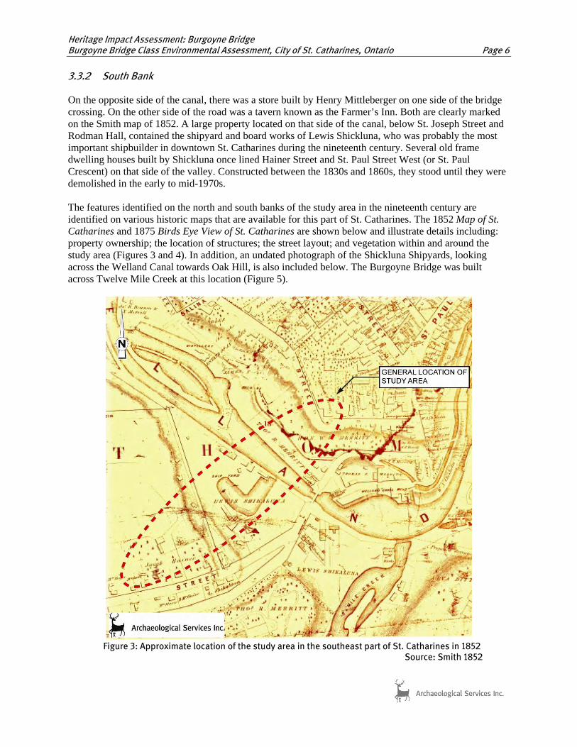
The early (pre-1818) wooden bridge, which was undoubtedly an immobile structure, would have been replaced prior to 1829 by some sort of swing-bridge to allow for the passage of ships. This swing bridge was replaced by a newer one in ca. 1875, which remained a conspicuous feature in the canal valley until it was removed sometime in the 1940s, at which time it was replaced by the steel through truss bridge which still spans the creek a short distance east of the Burgoyne Bridge. This swing bridge and the present Burgone Bridge was depicted in a watercolour view painted by John George Williams in the early twentieth century (Figures 6 and 7). This swing bridge was replaced
Figure 6: Watercolour of Old St. Paul Street Bridge in St. Catharines with the Burgoyne Bridge in background.
Source: St. Catharines Library.

Heritage Impact Assessment: Burgoyne Bridge Burgoyne Bridge Class Environmental Assessment, City of St. Catharines, Ontario Page 10
Figure 7: An aerial view from 1919-1920, showing the Burgoyne Bridge, old St. Paul Street Bridge, and Environs.
Source: St. Catharines Library. 3.4 Bridge Construction 3.4.1 Early Bridge Building in Ontario Up until the 1890s, timber truss bridges were the most common bridge type built in southern Ontario. Stone and wrought iron materials were also employed, but due to their higher costs and a lack of skilled craftsman, these structures were generally restricted to market towns. By the 1890s, steel was becoming the material of choice when constructing bridges given that it was less expensive and more durable than its wood and wrought iron predecessors. Steel truss structures were very common by 1900, as were steel girder bridges. The use of concrete in constructing bridges was introduced at the beginning of the twentieth century, and by the 1930s, it was challenging steel as the primary bridge construction material in Ontario (Ministry of Culture and Ministry of Transportation […]:7-8). 3.4.2 Construction of the Burgoyne Bridge As early as November 1867, the route from the Great Western Railway Station in the Western Hill, a community located southwest of the present bridge crossing, through the canal valley into the downtown core was seen as a major nuisance. The ascending and descending slope of the hill on the south side of the

Heritage Impact Assessment: Burgoyne Bridge Burgoyne Bridge Class Environmental Assessment, City of St. Catharines, Ontario Page 11
canal was not a problem for most people. The climb up the hill on the north side of the valley was, however, much more difficult. The hill was particularly notorious to travel on after wet or snowy weather, and farmers with heavily laden wagons frequently had to rest their teams on the uphill climb. A further hindrance to traffic was the swing bridge itself, which would frequently stop traffic altogether due to the passage of ships along the canal or for vessels bound for Shickluna’s shipyard. Editorials printed in the St. Catharines Constitutional called for the construction of a high level bridge in order to carry traffic along an easier route to and from the downtown core. This was viewed as “an immense benefit to the town, as the zig-zag, up-and-down hill road would no longer torture passengers and delay traffic” (quoted in Gannon 2008:D1; St. Catharines Standard, Feb. 1897.) The construction of a bridge “to the east” from Western Hill was once again raised by citizens and local politicians in 1888. However the matter did not then come to fruition, mainly due to the costs involved, as well as from a lack of general agreement concerning the site where the bridge ought to have been constructed (Standard, Jan. 14, 1911). The idea for a new bridge and improved vehicular access became a subject of great debate at city council beginning in the spring of 1910. In May of that year, Dr. W.H. Merritt and other citizens met at the Public Library and formed a group of bridge subscribers, in order to raise part of the funding necessary to erect a new bridge. The St. Catharines Evening Journal reported that this group had pledged $32,400 in subscribed stock towards this project. Plans were underway for incorporation of the company, and the election of company directors. Volunteers were solicited, who would canvass neighbourhoods in their respective wards in order to raise funds or secure pledges for the balance of the required stock (Journal, May 26, 1910). The Standard and the very few extant copies of the Journal carried news stories and editorials which closely followed the heated debates concerning the High Level Bridge throughout 1911 and 1912. It would appear that nearly everyone was in agreement that such a bridge was a necessity. The residents of Western Hill in particular felt that they were nearly in geographical isolation from the rest of the downtown, despite the fact that their neighbourhoods were included within the municipal urban boundary. A further incentive for the new bridge was the fact that new industries, such as the Rice-Hulbert Shoe Company, were attracted to the area and were setting up new factories in the Western Hill. The main difficulties that were raised time and again in these debates were 1) the cost of the new construction; 2) the location of the bridge; and 3) should the new bridge be “free” or charge a “toll” to its users (Standard, Jan. 31, 1912; undated Standard clipping, 1911). Four possible crossing points were selected for the new bridge: St. Paul Street, Trafalgar Street, Salina Street and King Street. The Trafalgar and Salina Street bridge approaches were eliminated from the discussions by December 1911. Both streets were heavily built up and were very narrow, which would frustrate the proposed plans to construct a double line of trolley or streetcar tracks to and from the bridge (Standard, Dec. 6, 1911). The ideal route favoured by nearly everyone was the King Street viaduct. This crossing point would have carried vehicular traffic and pedestrians to about the middle point of the Western Hill neighbourhood, and provided a much shorter trip to the railway station. It was also thought that the King Street access would carry the flow of traffic along a more direct line into the downtown core, and therefore closer to shops, schools, churches and other amenities. An architectural rendering for a proposed bridge at King Street was published in the Standard in early October 1913. It showed a graceful structure consisting of five arches, set upon piers, and very similar in appearance to the Prince Edward viaduct on Bloor Street at the Don Valley. The main obstacle to the King Street route (as with the others) was the fact that several houses stood in the way, including some which were (then) newly built structures. The city would have

Heritage Impact Assessment: Burgoyne Bridge Burgoyne Bridge Class Environmental Assessment, City of St. Catharines, Ontario Page 12
needed to expropriate them, at extra cost to the project, which “would delay the building of the bridge for two or three years” (Standard, December 4, 1911). St. Paul Street was the other strong contender for the site of the future bridge. It also contained private properties and houses which would require expropriation and demolition, but not as many as on the King Street route. It was estimated that the bridge at this point would have been about 150-200 feet shorter than the King Street alternative. The main objection to a bridge at St. Paul Street was the perception that it would benefit a smaller number of merchants and residents along St Paul to the detriment of other sections of the city. It would divert traffic away from King Street and from the neighbourhoods where a greater majority of the residents lived. “Instead of shortening the route to the station…it compelled these people, who comprise three-fourths of the population…to go to the corner of St. Paul and Ontario Streets, just as they do now, and practically saved nothing but the hills, as the St. Paul Street route is not in any sense even a direct route, but almost parallels the present route” (Standard, Dec. 7, 1911). Council was expected to select a site for the bridge in early December 1911; rather, council opted to defer making any final decision on the bridge location and the framing of any municipal by-law regarding the bridge until the municipal election in January of 1912. At that time, council withdrew its support for the St. Paul Street location, and sought the opinion of the electorate on this subject by means of a plebiscite (Standard, Dec. 7, 1911). If the bridge was tolled, it was estimated at that time that the average weekly revenues could have amounted to $251.70, or $13,088.40 per annum. It was argued that this amount would have eventually defrayed the construction costs and eased the burden on the local ratepayers, and would have made the bridge and its maintenance “self-sustaining.” It was further anticipated that additional funding towards the final cost of the construction would be provided by the Grand Trunk Railway ($20,000) and a further $50,000 by the Dominion Government. The bridge was finally paid for in part by the City through loans and debentures, with some private contributions (Standard Dec. 4, 1911, Feb. 10, 1914.) In late January 1914, Mr. N.S. Sprague, superintendent for the Bureau of Construction for the City of Pittsburg, PA, and an acknowledged expert on bridge construction, was invited to St. Catharines to view the various proposed plans and crossing sites. For various reasons, Sprague and the City engineers recommended the St. Paul route (St. Catharines Journal, Feb. 10, 1914.). In the summer of 1914, council passed a by-law to submit the question to the ratepayers. The St. Paul Street route was approved and the bridge by-laws were subsequently passed by council. The contract for the design of the bridge was awarded to Sprague and Reppert, consulting civil engineers, of Pittsburg, PA. The structure contained thirteen spans, for a total length of 1,236 feet. The seven central Warren truss spans each measured 120 feet in length. Steel on the bridge was grade “A7,” with a sheer strength of 36 kips per square inch. The bridge deck measured forty-one feet between the hand rails, with space for a thirty foot wide roadway. The original plans called for a concrete deck, but this was changed to creosoted, wood block pavement. The approach spans were carried by built-up plate girders five feet deep. The entire structure was supported by steel truss towers, which rested on four concrete piers each with a twelve foot square base. These concrete piers were supported by sixteen timber piles driven into the floor of the canal valley. The approach spans were supported by spread footings.
Heritage Impact Assessment: Burgoyne Bridge Burgoyne Bridge Class Environmental Assessment, City of St. Catharines, Ontario Page 13
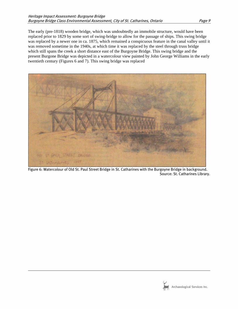
Pile driving was started by the Lincoln Construction Company on January 11, 1915, using a five ton steam hammer (Christensen [n.d.]: 37). The concrete piers had been completed by the early summer (Figure 8), and the first structural steel was ready for installation starting on the Western Hill side in the afternoon of July 6, 1915. Photographs show that the steel structural elements for the bridge were transported by a steam-powered crane or derrick which ran on a rail trestle from the railway to the west end of the bridge (Figures 9 - 10). The steel was transported to St. Catharines by rail. Construction of the bridge itself was undertaken by the Canadian Bridge Company of Walkerville, Ontario3. Supervision on the work was carried out by city engineers H.L. Clark and W.P. Near.
Figure 8: View of the bridge crossing with the concrete piers in place, looking north.
Source: [anon] n.d.
3 Some sources state that it was built by the Dominion Steel and Coal Corp. This company may have supplied the steel structural elements, which were then assembled by the Canadian Bridge Company.

Heritage Impact Assessment: Burgoyne Bridge Burgoyne Bridge Class Environmental Assessment, City of St. Catharines, Ontario Page 14
Figure 9: View of the work completed to date on the south side of the bridge crossing.
Source: [anon] n.d.

Heritage Impact Assessment: Burgoyne Bridge Burgoyne Bridge Class Environmental Assessment, City of St. Catharines, Ontario Page 15
Figure 10: Steam crane used on the project, 1915
Source: [anon] n.d.
The building of the bridge progressed rapidly, and by the last week of July the structural steel had nearly reached the bank of the Old Welland Canal. By the third week of September, the canal had been spanned and the steel structure had nearly reached Yates Street. The paving of the deck and installation of the handrails and lights occupied the next couple of months. Leveling of the approaches to the bridge was carried out by men with horse teams. The bridge was sufficiently completed and it was opened to pedestrian traffic sometime in late November 1915 (Figures 11 and 12). The first vehicular traffic was permitted to cross the bridge on the afternoon of December 18, 1915. Although there was no official ceremony to mark the occasion, word spread quickly and “hacks and motor buses seized the opportunity for a shorter route devoid of hills.” One of the first drivers to cross the new bridge was one J.B. Newman: “All I can say is that it is simply great. It is rather hard for us even yet to believe that it is really here, but we are using it and are tickled to death, as is every person else” (Standard, Dec. 20, 1915).

Heritage Impact Assessment: Burgoyne Bridge Burgoyne Bridge Class Environmental Assessment, City of St. Catharines, Ontario Page 16
Figure 11: Historic photograph of the Burgoyne Bridge over the old Welland Canal in St. Catharines, c.1915
Source: Photograph D418026, St. Catharines Library
Figure 12: Historic postcard of the Burgoyne Bridge over the old Welland Canal in St. Catharines, c.1915
Source: St. Catharines Library

Heritage Impact Assessment: Burgoyne Bridge Burgoyne Bridge Class Environmental Assessment, City of St. Catharines, Ontario Page 17
The cost of building the bridge amounted to $160,575.23, which was $4,424.77 under the estimated cost. An additional saving in the cost came from the fact that the steel for the bridge had been purchased before prices escalation brought on by the Great War. Additional costs were incurred by the City through the acquisition of properties along the rights-of-way or approaches to the bridge, as well as for the demolition of the old homes which stood there ($146,615.98). This demolition work continued into December 1915 (Standard, Dec. 17, 1915 p. 7; Jones & Meighan 1967:53). The bridge itself was officially known as the “St. Paul Street Viaduct” or the “St. Paul Street High Level Bridge” when it was constructed, but it has always been commonly referred to as the “High Level Bridge.” In June 1916, the name of the bridge was officially changed to that of the “Burgoyne Bridge.” This was in honour of William B. Burgoyne, who was formerly a city alderman and owner/publisher of the St. Catharines Standard newspaper. He served for two terms as the mayor of St. Catharines (1903, 1916-17), and contributed to various other philanthropic causes in the city. The “official” opening of the bridge was actually held during the “Old Boys Reunion” celebrations in 1921 (Gannon 2010). A line of streetcar or trolley tracks for the NS & T were extended across the bridge towards the railway station in 1917. In 1923, the hillside below the bridge on the northern end was donated to the City of St. Catharines by the Merritt family as Oak Hill Park. These terraced gardens and pathways were converted into a new rock garden accented with a variety of annual and perennial plants. This has sadly been permitted to fall into decay in recent years (Jones & Meighan 1967:55; Jackson & Wilson 1992:256). Two tunnels formerly linked the basement in the Merritt House at the top of the hill to the banks of Twelve Mile Creek. These were sealed up in 1967, and their exact locations are unknown at this time (Anon 2010). Various repairs have been made on the Burgoyne Bridge throughout the years. The old streetcar tracks across the bridge were removed in 1962. Costly and necessary repairs were made to the structure in 1962, 1975, 1979 and 1989, which included replacement of the deck and paving, repairs to the expansion joints, and painting of the structural steel. Weight tests and lesser repairs have been carried out on the bridge from time to time. Despite gradual decay to the overall structure during the last century, the bridge has provided a good and necessary service for the citizens of St. Catharines and the Niagara Region in general throughout the years. The present day appearance of the bridge remains virtually unchanged since the time when it was first built. The only major difference has been the installation of new light standards/fixtures on the bridge, which replaced those that were originally installed in 1915. 4.0 EXISTING CONDITIONS AND INTEGRITY A field review was undertaken by Lindsay Popert on March 15, 2011, to conduct photographic documentation of the bridge crossing and to collect data relevant for completing a heritage evaluation of the structure. Results of the field review and bridge inspection reports received from the client were then utilized to describe the existing conditions of the bridge crossing. This section provides a general description of the bridge crossing and associated cultural heritage features. Photographic documentation of the bridge crossing is provided in Appendix A. Original structural drawings and plans are provided in Appendix B. The Burgoyne Bridge is located in the City of St. Catharines and is owned and maintained by the Regional Municipality of Niagara. The bridge spans Twelve Mile Creek, which also served as the first

Heritage Impact Assessment: Burgoyne Bridge Burgoyne Bridge Class Environmental Assessment, City of St. Catharines, Ontario Page 18
Welland Canal, and thus is considered to be a significant cultural heritage feature in the area given its role in the development and growth of St. Catharines in the early nineteenth century. The Burgoyne Bridge is not listed on the Ontario Heritage Bridge List, and it is not municipally listed or designated under Part IV of the Ontario Heritage Act. The Yates Street Heritage Conservation District is located immediately adjacent to the bridge, on the west side of its northern approach. Twelve Mile Creek and the associated valley was drastically altered by the construction of Highway 406 in the 1960s. The remains of surviving nineteenth century industrial complexes along the north banks of the waterway were removed and the original St. Paul Street road alignment was altered. A remnant road (formerly Brewery Street) running along the north side of the highway and under the subject bridge has been reused as a recreational path and incorporated into the City’s trail system. The Burgoyne Bridge features a steel superstructure consisting of seven steel warren deck truss spans bounded at either end by slab on steel girder sections. There are a total of seventeen bents and five expansion joints. Concrete abutments and steel tower piers resting on concrete pedestals support the deck truss and girder construction. The reinforced concrete deck with latex modified concrete overlay is supported by transverse floor beams and longitudinal stringers. The bridge features riveted connections, v-lacing and lattice work throughout. The bridge measures 370 m in length and has an overall width of 12.5 m. The bridge deck is bounded to the east and west by concrete sidewalks, which are attached to the structure with fascia girders and brackets supports. Vehicular traffic is bounded by a concrete barrier wall, while the sidewalks are bounded by a steel hand railing. A section of chain link fence in located on the outside of the bridge in the area where Highway 406 travels under the bridge. The northern approach is bounded by low stone walls, while the southern approach is bounded by paneled concrete parapet walls. The bridge remains generally intact. In the report Burgoyne Bridge: Evaluation, Inspection and Rehabilitation/Replacement Analysis (Hatch Mott MacDonald 2010:5), a list of major rehabilitative efforts were documented, as follows:
1947 Splash guard erected on west edge of sidewalk to separate vehicles from pedestrian traffic.
Pre-1962 Removal of original timber deck over existing reinforced concrete slab, and replacement with asphalt pavement over the existing slab.
1962 Rehabilitation contract consisted of removing rail tracks, replacement of existing unreinforced concrete slab with reinforced concrete, abutment concrete repair, bent concrete repair, expansion joint replacement, drainage works, east sidewalk replacement to accommodate electrical conduits, and tying back the south abutment to adjacent bent.
1975 Replacement of original truss roller bearings with elastomeric bearings. 1975 Various repairs to steel structure including sidewalk brackets, bolts, lattice
ties, drainage downspout installation, and concrete repairs to north abutment.
1976 Repainting of all steel members. 1978 Modified latex concrete overlay poured over existing concrete slab. 1980 Gusset plates of fixed column supports coped to allow expansion of the
truss (concluded in 1981 to have been caused by global movements of the south embankment towards the north).
1988 Repairs to increase bearing area at various bent supports due to deteriorated concrete, and re-facing of abutments.
1989 Deck and lighting improvements, parapet wall construction, and expansion joint replacement.

Heritage Impact Assessment: Burgoyne Bridge Burgoyne Bridge Class Environmental Assessment, City of St. Catharines, Ontario Page 19
1990-1 Structural strengthening of selected steel end verticals, truss verticals, floor beams, columns and all sidewalk brackets, re-coating of steel, and encasing column at Bent #16 in concrete.
The above-mentioned report (Hatch Mott MacDonald 2010: i) found the bridge to be in fair to poor condition. It recommended that the bridge load posting be further reduced immediately, and reports that “as a result of the general condition of the structure, the life cycle cost analysis and overall safety and risk of rehabilitation, the preferred option is the replacement of the bridge with a new structure adjacent to the existing bridge” (Hatch Mott MacDonald 2010:43). 4.1 Comparative Geographic and Historic Context of Steel Truss Bridges A review of the Niagara Region Structure Database, as well as Heritage Bridges: Identification and Assessment Guide, Ontario 1945 – 1965, it was determined that this bridge may be considered a rare example of its type. The regional database records that the Burgoyne Bridge type as ‘other’. Additional bridges listed as ‘other’ were dissimilar to the subject bridge given materials employed in their construction, their age, and dimensions. Further, the Burgoyne Bridge is shown to be the longest spanning bridge owned by the Region, with 12 Mile Creek Bridge at Fourth Ave. Louth in St. Catharines coming in second. In addition, the subject bridge is the second oldest structure in the Region, the oldest being the St. Paul West CNR Bridge which was built in 1910. The 1945 – 1965 Guide, which only considers provincially owned structures, listed ten deck truss structures in Ontario for that time period. While further information about the construction of these bridges is not provided in the Guide, only the Oakville Creek Bridge, built in 1960, and the Hogg’s Hollow Bridge (express lanes), built in 1959 in Toronto are of any comparison with regards to overall span length. However, concrete piers rather than steel bents resting on concrete pedestals were used in the construction of these bridges. 4.2 Additional Cultural Heritage Resources The Burgoyne Bridge is located immediately adjacent to the Yates Street Heritage Conservation District. Based on a map of the district, provided below (Figure 12), the terraced gardens and part of the northern approach to the bridge are actually located within the boundaries of the district. The street was established as a heritage conservation district under Part V of the Ontario Heritage Act in 1996. The boundaries extend from the eastern terminus of Yates Street, at St. Paul Street, westerly to just east of Adams Street. The southern boundary is demarcated by Highway 406, while the northern boundary extends along Ontario Street and Cherry Street. This historic residential area developed in the late 1800s and early 1900s on land originally owned by the Honourable William H. Merritt. A number of important industries were established along this section of the first Welland Canal in the nineteenth century, and as such, many of the mill owners and company managers built their residences on Yates Street which overlooked the canal below. Of particular note is: 12 Yates Street, the former Merritt home; the stone walls at the top of the valley to either side of the north approach to the bridge, reportedly remnants of the Merritt family estate (Anon 2010); and Oak Hill Park, the former Merritt estate gardens, located south of Yates Street next to and underneath the subject bridge. Also located to the north of the bridge is the Cenotaph at Memorial Park, and the William Merritt Monument, a bronze statue at the corner of St. Paul Street and McGuire Street.

Heritage Impact Assessment: Burgoyne Bridge Burgoyne Bridge Class Environmental Assessment, City of St. Catharines, Ontario Page 20
A steel through truss bridge built in the 1940s at the original St. Paul Street Bridge crossing is located approximately 57 metres east of the Burgoyne Bridge. This bridge replaced a former swing bridge at this location. The bridge is closed to vehicular traffic; however, it remains open to pedestrians and cyclists. A number of additional properties of potential heritage interest are located on the south side of Twelve Mile Creek, to either side of the bridge. The former Shickluna Shipyards to the west of the bridge are now being used by the fire department for training. Further up the hill, on St. Joseph Street, are a few nineteenth century residences that may have been associated with the Shickluna Shipyard, as indicated on early nineteenth century mapping. Also of note are a collection of residential properties, which likely date from the late nineteenth century to the early twentieth century, located at the southern approach at the top of Hainer Street and along Henrietta Street. Rodman Hall is located south of the study area, on St. Paul Crescent.
Figure 13: Plan showing boundaries, streets and properties within the Yates Street Heritage Conservation District
Source: City of St. Catharines 1996 5.0 HERITAGE EVALUTION OF THE BURGOYNE BRIDGE Table 1 contains the evaluation of the Burgoyne Bridge against criteria as set out in Ontario Heritage Act Regulation 9/06.

Heritage Impact Assessment: Burgoyne Bridge Burgoyne Bridge Class Environmental Assessment, City of St. Catharines, Ontario Page 21
Table 1: Evaluation of the Burgoyne Bridge using Ontario Heritage Act Regulation 9/06 1. The property has design value or physical value because it : Ontario Heritage Act Criteria Analysis i. is a rare, unique, representative or early example of a style, type, expression, material or construction method;
Based on available data, the bridge is a rare and early example of a high level deck truss and slab on steel girder bridge that is supported by steel bents on concrete pedestals. It is notable for being the second oldest bridge in the area owned by the Region of Niagara, and it has the longest overall span when compared to other bridges owned by the Region.
ii. displays a high degree of craftsmanship or artistic merit, or;
The Burgoyne Bridge is not known to display any elements of superior materials or craftsmanship. However, bridge features of note are the high level deck trusses, the low stone walls extending from the north approach, and the paneled concrete parapet walls on the south approach.
iii. demonstrates a high degree of technical or scientific achievement.
Given the size and early construction date of the structure, the Burgoyne Bridge is considered to be an impressive technological and engineering achievement of its day.
2. The property has historical value or associative value because it: Ontario Heritage Act Criteria Analysis i. has direct associations with a theme, event, belief, person, activity, organization or institution that is significant to a community;
The bridge has a direct association with the growth and development of St. Catharines in the early twentieth century. In particular, it linked the community of Western Hill to the downtown area. As a result, it encouraged growth and provided a more direct and efficient route to the downtown core from the south. The subject bridge, formerly known as St. Paul Street Viaduct or St. Paul Street High Level Bridge, also retains direct associations with William B. Burgoyne, for whom the bridge was officially renamed after in 1916. Mr. Burgoyne was a former city alderman, former mayor, and the owner/ publisher of the St. Catharines Standard newspaper.
ii. yields, or has the potential to yield, information that contributes to an understanding of a community or culture, or;
The structure is not known to meet this criterion.
iii. demonstrates or reflects the work or ideas of an architect, artist, builder, designer or theorist who is significant to a community.
Reflects the work of an American engineering firm, Sprague and Reppert of Pittsburgh, Consulting Engineers, the Dominion Steel and Coal Corporation, and the Canadian Bridge Company of Walkerville. While Sprague and Reppert are not known to have made any significant contributions to civil engineering in Ontario, the Canadian Bridge Company is responsible for the fabrication, detailing and erection of a large number of bridges across the province while the Dominion Steel and Coal Corporation built the steel components.
3. The property has contextual value because it: Ontario Heritage Act Criteria Analysis i. is important in defining, While it does not define the character of the valley lands and the historic

Heritage Impact Assessment: Burgoyne Bridge Burgoyne Bridge Class Environmental Assessment, City of St. Catharines, Ontario Page 22
Table 1: Evaluation of the Burgoyne Bridge using Ontario Heritage Act Regulation 9/06 maintaining or supporting the character of an area;
core of St. Catharines, the bridge does support the historic character of the area through its age, association with the St. Paul Street realignment in the early twentieth century, and reconfiguration of the eastern terminus of Yates Street, now part of the Yates Street Heritage Conservation District.
ii. is physically, functionally, visually or historically linked to its surroundings, or;
The site of the Burgoyne Bridge in St. Catharines is a traditional river crossing and therefore contributed significantly to the historical development of the city. A number of earlier structures spanned Twelve Mile Creek just to the east of the subject bridge, where the current steel through truss bridge is located. The truss bridge carries the original St. Paul Street alignment. Given that this was an important thoroughfare through St. Catharines, a number of industries and prominent residences and residential areas were established in the vicinity. While the former industries along the banks of the creek have been demolished, the late nineteenth and early twentieth century residential areas are located to the north and south of the bridge site.
iii. is a landmark. The bridge figures prominently in the community given its size, placement, and role as one of the main entranceways into the downtown core. The bridge forms part of the scenic value of the Twelve Mile Creek valley, and is easily viewed from surrounding residential neighbourhoods at the top of the valley, from the city’s recreational trail system, from the creek and from Highway 406. The trail system passes underneath the northern spans of the bridge, north of Highway 406, through an area of overgrown gardens, terraces and pathways first formed in the nineteenth century as part of the Merritt Estate.
Given that the Burgoyne Bridge met at least one of the criteria contained in Regulation 9/06, this cultural heritage resource may be considered for municipal designation under the Ontario Heritage Act. In particular, it was determined to retain strong historical and contextual values given its location at a traditional bridging point and association with the historic development of St. Catharines, and strong design values given its bridge type, age and status as a high level bridge. In summary, character-defining elements associated with the Burgoyne Bridge include, but are not limited to:
• Warren deck truss system; • Paneled concrete parapet walls at south approach; • Stone retaining walls at north approach; • Open steel railings and newel post design; • Incorporation of former landscape elements associated with the Merritt Estate, such as the
terraced pathways and gardens on the north bank and low stone walls to either side of the north approach;
• Its current alignment which retains historical associations with the realignment of St. Paul Street in the early twentieth century to accommodate a high level bridge in this area;
• The high level design of the bridge allows for expansive views of the valley lands to the east and west as well as views to Oak Hill, which is prominently sited at the north end of the structure and marks the southeast corner of the Yates Street Heritage Conservation District; and
• Views to the bridge from the valley lands and the surrounding residential neighbourhoods at the top of the valley express its landmark value.

Heritage Impact Assessment: Burgoyne Bridge Burgoyne Bridge Class Environmental Assessment, City of St. Catharines, Ontario Page 23
6.0 ALTERNATIVES TO BE CONSIDERED FOR HERITAGE BRIDGES AS PART OF THE ENVIRONMENTAL ASSESSMENT PROCESS
Following the evaluation of the subject cultural heritage resource, the Burgoyne Bridge was determined to retain cultural heritage value. The conservation options presented below are contained in the Ontario Heritage Bridge Program guidelines (1991), which is regarded as the current best practice for conserving heritage bridges in Ontario and ensures that heritage concerns, and appropriate mitigation options, are considered. The following nine conservation options are arranged according to level or degree of intervention from minimum to maximum:
1. Retention of existing bridge and restoration of missing or deteriorated elements where physical or documentary evidence (e.g. photographs or drawings) can be used for their design;
2. Retention of existing bridge with no major modifications undertaken; 3. Retention of existing bridge with sympathetic modification; 4. Retention of existing bridge with sympathetically designed new structure in proximity; 5. Retention of existing bridge no longer in use for vehicle purposes but adapted for pedestrian
walkways, cycle paths, scenic viewing etc.; 6. Relocation of bridge to appropriate new site for continued use or adaptive re-use; 7. Retention of bridge as heritage monument for viewing purposes only; 8. Replacement/removal of existing bridge with salvage elements/members of heritage bridge for
incorporation into new structure or for future conservation work or displays; 9. Replacement/removal of existing bridge with full recording and documentation of the heritage
bridge. Given that the bridge was evaluated to retain cultural heritage value under Regulation 9/06, all nine of these conservation options should be considered as part of the Burgoyne Bridge Class Environmental Assessment. 7.0 ENVIRONMENTAL ASSESSMENT OPTIONS The Region of Niagara retained Delcan Corporation to provide Consulting Engineering Services for the Burgoyne Bridge Class Environmental Assessment and Preliminary Design. As part of the study, the nine conservation alternatives listed in Section 6.0 are under consideration as bridge improvement alternatives. 7.1 Evaluation of Impacts To assess the potential impacts of the undertaking, the cultural heritage resource and identified heritage attributes were considered against a range of possible impacts as outlined in the Ministry of Tourism and Culture document entitled Screening for Impacts to Built Heritage and Cultural Heritage Landscapes (September 2010), which include: • Destruction of any, or part of any, significant heritage attribute or feature (III.1). • Alteration which means a change in any manner and includes restoration, renovation, repair or
disturbance (III.2). • Shadows created that alter the appearance of a heritage attribute or change the visibility of a natural
feature of plantings, such as a garden (III.3). • Isolation of a heritage attribute from it surrounding environment, context, or a significant relationship
(III.4).

Heritage Impact Assessment: Burgoyne Bridge Burgoyne Bridge Class Environmental Assessment, City of St. Catharines, Ontario Page 24
• Direct or indirect obstruction of significant views or vistas from, within, or to a built and natural feature (III.5).
• A change in land use such as rezoning a battlefield from open space to residential use, allowing new development or site alteration to fill in the formerly open spaces (III.6).
• Soil Disturbance such as a change in grade, or an alteration of the drainage pattern or excavation (III.7).

Heritage Impact Assessment: Burgoyne Bridge Burgoyne Bridge Class Environmental Assessment, City of St. Catharines, Ontario Page 25
Table 2: Evaluation of the Potential Impacts of Bridge Improvement Alternatives on the Cultural Heritage Resource and Identified Heritage Attributes Nine Bridge Improvement Alternatives Destruction, removal or
relocation Alteration Shadows Isolation Direct or indirect obstruction
A change in land use Soil disturbance
1) Retention of existing bridge and restoration of missing or deteriorated elements where physical or documentary evidence (e.g. photographs or drawings) can be used for their design
No impact. No impact. No impact. No impact. No impact. No impact. No impact.
2) Retention of existing bridge with no major modifications undertaken
No impact. No impact. No impact. No impact. No impact. No impact. No impact.
3) Retention of existing bridge with sympathetic modification
No impact. No impact given that alterations would be sympathetic to heritage attributes.
No impact. No impact. No impact. No impact. No impact.
4) Retention of existing bridge with sympathetically designed new structure in proximity
No impact. Yes – impacts are expected given that a new bridge in proximity to the existing one will alter the immediate setting and context of the bridge site.
No impact. No impact. Yes – views of surrounding landscape (i.e. Oak Hill, Yates Street Heritage Conservation District, terraced gardens, low stone walls and valley lands) will be altered.
No impact. Yes – impacts are expected through the construction of a new structure in proximity.
5) Retention of existing bridge no longer in use for vehicle purposes but adapted for pedestrian walkways, cycle paths, scenic viewing, etc
No impact. Yes – a change in use would result in alterations to the heritage resource.
No impact. No impact. No impact. Yes – use of bridge for pedestrian walkways, cycle paths, scenic viewing, et cetera, would result in a change from the original use of the structure.
No impact.
6) Relocation of bridge to appropriate new site for continued use or adaptive re-use
Yes – impacts to the heritage resource are expected through relocation.
Yes – alterations to the resource are expected through relocation.
No impact. Yes – relocation of the resource will isolate it from its original context.
Yes – views of surrounding landscape (i.e. Oak Hill, Yates Street Heritage Conservation District, terraced gardens and low stone walls) will be altered.
Yes – the adaptive re-use of the bridge for purposes other than vehicular purposes would result in a change from the original use of the structure. If the bridge remains in vehicular use, no impact is expected.
Yes – impacts are expected through process of removing the bridge from its current location.
7) Retention of bridge as heritage monument for viewing purposes only
No impact. Yes – use of bridge for viewing purposes only would result in a change from the original use of the structure and thus is considered to be an alteration.
No impact. No impact. No impact. Yes – use of bridge for viewing purposes only would result in a change from the original use of the structure.
No impact.
8) Replacement/removal of existing bridge with salvage elements/members of heritage bridge for incorporation into new structure or for future conservation work or displays
Yes - impacts to the heritage resource are expected through removal
Yes – alterations to the resource are expected through removal.
No impact.
No impact.
No significant impacts to the surrounding landscape are expected provided that the new bridge retains a similar scale, grade and alignment.
No impact. Yes – impacts are expected through removal of the existing bridge and the introduction of a new structure.
9) Replacement/removal of existing bridge with full recording and documentation of the heritage bridge
Yes - impacts to the heritage resource are expected through removal.
Yes – alterations to the resource are expected through removal.
No impact.
No impact. No significant impacts to the surrounding landscape are expected provided that the new bridge retains a similar scale, grade and alignment.
No impact. Yes – impacts are expected through removal of the existing bridge and the introduction of a new structure.

Heritage Impact Assessment: Burgoyne Bridge Burgoyne Bridge Class Environmental Assessment, City of St. Catharines, Ontario Page 26
8.0 CONCLUSIONS The Burgoyne Bridge is a multi-span steel deck truss and slab on steel girder bridge that was designed by Sprague and Reppert in 1914 and built in 1915 by the Canadian Bridge Company of Walkerville. The structure was built to carry the newly realigned St. Paul Street over Twelve Mile Creek in the City of St. Catharines. The bridge has undergone a number of modifications, including: replacement of original timber deck with asphalt pavement; the removal of centre-line rail tracks in 1962; incorporation of concrete barriers between the sidewalks and roadway; and structural strengthening of selected steel components. However, the overall design, scale and visual integrity of the bridge is maintained give that the modifications made to the bridge were considered to be sympathetic (i.e. maintaining open-concept hand railing system). 8.1 Summary Statement of Cultural Heritage Value The Burgoyne Bridge retains moderate historical associations with the historical development of St. Catharines given its role in the community as link between Western Bank and the downtown core, thus enabling development and growth. Further, the bridge retains historical associations with its designer, Sprague and Reppert, Consulting Engineers from Pittsburgh, and its assembler, the Canadian Bridge Company of Walkerville. The Canadian Bridge Company is noted for its involvement in the construction of a large number of bridges across the province. The design value of the structure is of high significance given that it is considered to be a rare and early example of a high level deck truss and slab on steel girder bridge that is supported by steel bents on concrete pedestals. It is notable for being the second oldest bridge in the area owned by the Region of Niagara, and it has the longest overall span when compared to other bridges owned by the Region. Given the size, early construction date, and continued use of the structure, the Burgoyne Bridge is considered to be an impressive technological and engineering achievement of its day. The bridge retains strong contextual values resulting from its: landmark status within the community; contribution to the character of the valley through its current alignment and scale; siting at a traditional river crossing; spatial and visual associations with the Yates Street Heritage Conservation District; and relationship with the former bridges that previously carried St. Paul Street over Twelve Mile Creek. In summary, character-defining elements associated with the Burgoyne Bridge include, but are not limited to:
• Warren deck truss system; • Paneled concrete parapet walls at south approach; • Stone retaining walls at north approach; • Open steel railings and newel post design; • Incorporation of former landscape elements associated with the Merritt Estate, such as the
terraced pathways and gardens on the north bank and low stone walls to either side of the north approach;
• Its current alignment which retains historical associations with the realignment of St. Paul Street in the early twentieth century to accommodate a high level bridge in this area;
• The high level design of the bridge allows for expansive views of the valley lands to the east and west as well as views to Oak Hill, which is prominently sited at the north end of the

Heritage Impact Assessment: Burgoyne Bridge Burgoyne Bridge Class Environmental Assessment, City of St. Catharines, Ontario Page 27
structure and marks the southeast corner of the Yates Street Heritage Conservation District; and
• Views to the bridge from the valley lands and the surrounding residential neighbourhoods at the top of the valley express its landmark value.
9.0 RECOMMENDATIONS Based on the results of archival research, an analysis of bridge design and construction in Ontario, field investigations and application of Regulation 9/06 of the Ontario Heritage Act, the Burgoyne Bridge was determined to retain heritage value and may be considered for municipal designation under the Ontario Heritage Act. In particular, it was determined to retain strong historical and contextual values given its location at a traditional bridging point and association with the historic development of St. Catharines, and strong design values given its bridge type, age and status as a high level bridge. Following the evaluation of potential impacts on the heritage resource (see Table 3), it was determined that Conservation Alternatives 1 – 3 are the preferred alternatives, given that no impacts are expected to the heritage resource and its identified heritage attributes, with Alternative 1 being the most preferred. The remaining conservation alternatives (4 – 9) have a range of impacts, with Alternatives 8 and 9 being the least preferred options given the level and nature of the impacts resulting from removal of the bridge. Given the identified heritage value of the Burgoyne Bridge, the following recommendation and mitigation measures should be considered and implemented:
1. Based on the results of heritage evaluation, Conservation Alternatives 1 -3 are the preferred
alternatives, with Alternative 1 being the most preferred. As part of the selection of the preferred alternatives as part of the Environmental Assessment, a clear rationale for the proposed course of action should be documented.
2. This report should be filed with the Heritage Planning Section at the City of St. Catharines,
the St. Catharines Heritage Committee, and other local heritage stakeholders that may have an interest in this project.
3. This report should be filed with the Ministry of Tourism and Culture review and comment. 4. Should retention of the bridge be chosen as the preferred alternative (one of Conservation
Alternatives 1 – 7), the character-defining elements identified in Section 8.1 should be retained and treated sympathetically.
5. Should replacement of the bridge be chosen as the preferred alternative (Conservation
Alternative 8 or 9), two mitigation options should be considered:
a. Replacement/removal of existing bridge and construction of a new bridge with replication of the appearance of the heritage bridge in the new design, with allowances for the use of modern materials. The character-defining elements identified in Section 8.1 should be considered for replication.
b. Replacement/removal of existing bridge and construction of a new bridge with
historically sympathetic design qualities to the heritage bridge, with allowances for the use of new technologies and materials.

Heritage Impact Assessment: Burgoyne Bridge Burgoyne Bridge Class Environmental Assessment, City of St. Catharines, Ontario Page 28
c. In addition to (a) and (b), development of a commemorative strategy, such as
plaquing, may be appropriate. 10.0 REFERENCES A. Books and Manuscripts. [anon.]
n.d. The Daily Standard and the St. Catharines Journal, photocopied scrapbook of articles on the Burgoyne Bridge published between May 26, 1910 and Dec. 20, 1915.
1959 “After 44 Years of Solid Use: Burgoyne Bridge To Get Face-Lift,” St. Catharines Standard, Oct. 22, 1959.
Christensen, Carl J.
n.d. History of Engineering in Niagara. Niagara Peninsula Branch, Engineering Institute of Canada, pp. 36-37.
Gannon, Dennis. 2008 “Yesterday and Today,” St. Catharines Standard, Nov. 1, 2008, p. D1. 2010 “Yesterday and Today,” St. Catharines Standard, Mar. 6, 2010, p. D1. 2011 “Yesterday and Today,” St. Catharines Standard, Jan. 22, 2011. Hatch Mott MacDonald 2010 Burgoyne Bridge: Evaluation, Inspection and Rehabilitation/Replacement Analysis. Jackson, John N. and Sheila M. Wilson.
1992 St. Catharines: Canada’s Canal City. St. Catharines: St. Catharines Standard Limited. Jones, V.C. and Harold Meighan.
1967 St. Catharines Centennial History 1867-1967. St. Catharines: Advance Print. Lizars, Amy.
2007 “Burgoyne Bridge: A Tribute to Early Vision,” St. Catharines Standard, April 19, 2007 p. A5.
Michelle Greenwald et al. 1979 The Welland Canals: Historical Resource Analysis and Preservation Alternatives.
Toronto: Historical Planning and Research Branch Ontario Ministry of Culture and Recreation.
Ministry of Culture, Ontario (MCL)
2005 Ontario Heritage Act. 2006 Ontario Heritage Tool Kit
Ministry of Culture and Communications, Ontario
1992 Guidelines for Preparing the Cultural Heritage Resource Component of Environmental Assessments.
Ministry of Culture and Recreation, Ontario (MCR)
1981 Guidelines on the Man-Made Heritage Component of Environmental Assessments.

Heritage Impact Assessment: Burgoyne Bridge Burgoyne Bridge Class Environmental Assessment, City of St. Catharines, Ontario Page 29
Ministry of Environment, Ontario 2006 Environmental Assessment Act Ministry of Tourism and Culture, Ontario 2010 Screening for Impacts to Built Heritage and Cultural Heritage Landscapes. Ministry of Transportation (MTO)
2006 Environmental Reference for Highway Design 2006 Environmental Standards and Practices 2006 Cultural Heritage – Built Heritage and Cultural Heritage Landscapes: Technical
Requirements for Environmental Impact Study and Environmental Protection/Mitigation. 2007 Environmental Guide for Built Heritage and Cultural Heritage Landscapes
Ministry of Transportation and Ministry of Culture and Communications, Ontario 1991 Ontario Heritage Bridge Program, Information Package. Page & Co.
1876 Illustrated Historical Atlas of the Counties of Lincoln and Welland, Ontario. Toronto: H.R. Page.
Pihl, Robert H. and Robert Shipley
1990 A Survey of Historic Structures: The Welland Canal Industrial Corridor. Welland Canals Society Archaeology Project.
Powell, Kathleen.
2009 Burgoyne Bridge: Presentation to the Niagara Regional Culture Committee, July 19, 2009.
Smith, W.H. 1846 Smith’s Canadian Gazetteer. Toronto: H. & W. Rowsell. Taylor, Corlene. 1993 Hainer from Niagara. St. Catharines: House of Dwyer Wilson, Bruce G.
1983 “Robert Hamilton,” Dictionary of Canadian Biography vol. V (1801-1820), pp. 402-406. Winearls, Joan.
1991 Mapping Upper Canada 1780-1867. An Annotated Bibliography of Manuscript and Printed Maps. Toronto: University of Toronto Press.
B. Maps. Brosius, H.
1875 St. Catharines, Province Ontario, Canada, 1875. Chicago: lithographed by Charles Shober & Co.
Maingy, Robert A.
1836 Map of the Village of St. Catharines. Niagara North Land Registry Office, Plan No. 77.

Heritage Impact Assessment: Burgoyne Bridge Burgoyne Bridge Class Environmental Assessment, City of St. Catharines, Ontario Page 30
Sabiston. 1898 St. Catharines Ont. and Surroundings. Montreal: Sabiston Lith. & Pub. Co.
Smith, Marcus. 1852 Map of the Town of St. Catharines, Canada West.
C. Websites: [anon.]
2010 “Oak Hill, William Hamilton Merritt Estate”, in the Niagara Greenbelt Website accessed on March 28, 2011 at http://www.niagaragreenbelt.com/listings/54-historic-houses/376-oak-hill-william-hamilton-merritt-estate.html
City of St. Catharines
1996 “Yates Street Heritage Conservation District” accessed on March 28, 2011 at http://www.stcatharines.ca/en/buildin/resources/Yates_Heritage_District.pdf
Welland Canals Society Archaeology Project 1990 A Survey of Historic Structures: The Welland Canal Industrial Corridor. On file with the
author.

Heritage Impact Assessment: Burgoyne Bridge Burgoyne Bridge Class Environmental Assessment, City of St. Catharines, Ontario Page 31
APPENDIX A:
Photographic Plates
Plate 1: South approach.
Plate 2: View of bridge deck and sidewalks, looking north.

Heritage Impact Assessment: Burgoyne Bridge Burgoyne Bridge Class Environmental Assessment, City of St. Catharines, Ontario Page 32
Plate 3: Southeast wing wall and southern most span. St. Joseph’s Street travels underneath the bridge.
Plate 4: East elevation, view from the southeast.

Heritage Impact Assessment: Burgoyne Bridge Burgoyne Bridge Class Environmental Assessment, City of St. Catharines, Ontario Page 33
Plate 5: Oblique view of the east elevation, from the top of the south bank.
Plate 6: Oblique view of the west elevation, from the top of the south bank.

Heritage Impact Assessment: Burgoyne Bridge Burgoyne Bridge Class Environmental Assessment, City of St. Catharines, Ontario Page 34
Plate 7: West elevation of southern most span. Note proximity of residential properties to the bridge approach.
Plate 8: West elevation, view from the end of St. Joseph’s Street.

Heritage Impact Assessment: Burgoyne Bridge Burgoyne Bridge Class Environmental Assessment, City of St. Catharines, Ontario Page 35
Plate 9: View of south abutment.
Plate 10: View of deck trusses from south abutment, looking north.

Heritage Impact Assessment: Burgoyne Bridge Burgoyne Bridge Class Environmental Assessment, City of St. Catharines, Ontario Page 36
Plate 11: North approach, looking southwest towards Yates Street. The bridge structure extends westerly to accommodate the Yates Street and St. Paul Street intersection.
Plate 12: View of bridge deck and sidewalks, looking south from the east-side sidewalk.

Heritage Impact Assessment: Burgoyne Bridge Burgoyne Bridge Class Environmental Assessment, City of St. Catharines, Ontario Page 37
Plate 13: View of bridge deck and sidewalks, looking south from the west-side sidewalk.
Plate 14: Oblique view of the west elevation, from the top of the north bank.

Heritage Impact Assessment: Burgoyne Bridge Burgoyne Bridge Class Environmental Assessment, City of St. Catharines, Ontario Page 38
Plate 15: West elevation from the north bank, just north of Highway 406.
Plate 16: Oblique view of the east elevation, from the top of the north bank.

Heritage Impact Assessment: Burgoyne Bridge Burgoyne Bridge Class Environmental Assessment, City of St. Catharines, Ontario Page 39
Plate 17: Oblique view of the east elevation from the valley lands located north of Twelve Mile Creek.
Plate 18: View of deck truss and steel bents resting on concrete pedestals.

Heritage Impact Assessment: Burgoyne Bridge Burgoyne Bridge Class Environmental Assessment, City of St. Catharines, Ontario Page 40
Plate 19: Looking towards the north abutment.
Plate 20: Looking south under the bridge from the north abutment.

Heritage Impact Assessment: Burgoyne Bridge Burgoyne Bridge Class Environmental Assessment, City of St. Catharines, Ontario Page 41
Plate 21: View of steel girders and bracket supports under sidewalks.
Plate 22: Bridge soffit, northern girder span.
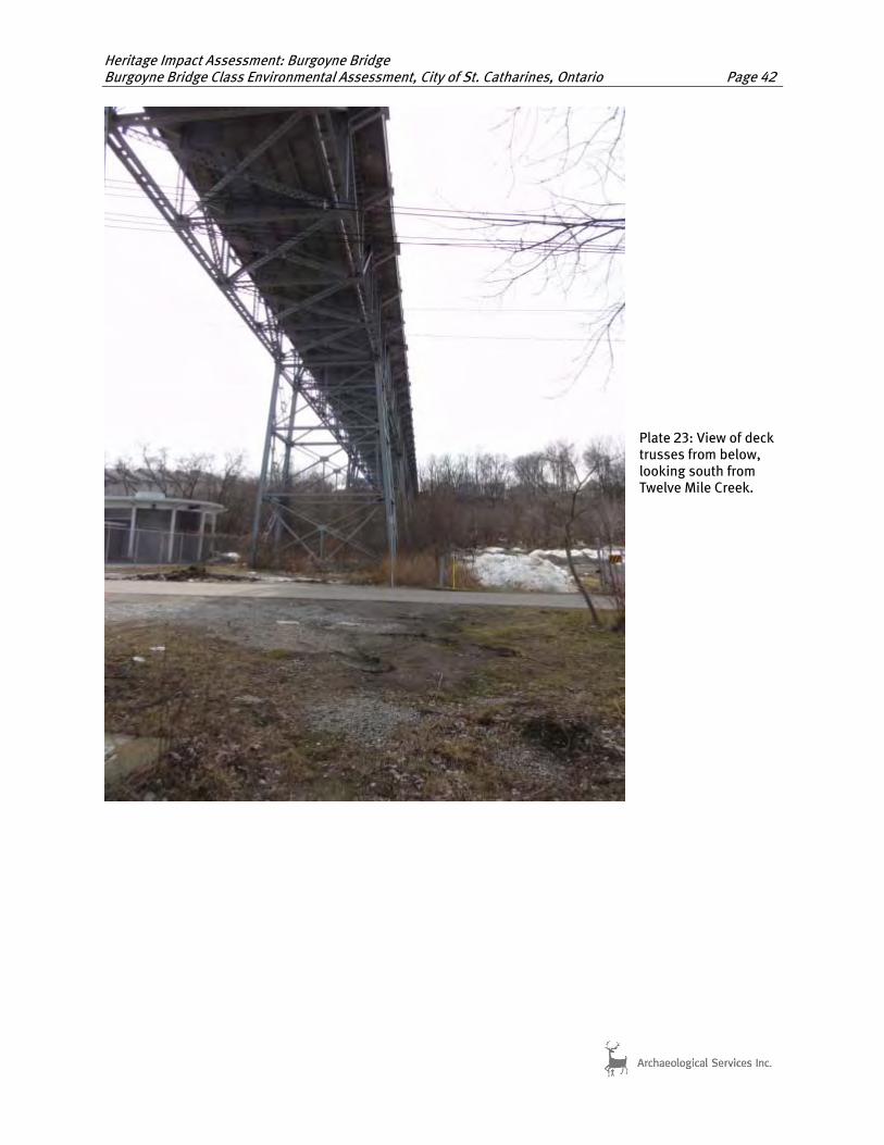
Heritage Impact Assessment: Burgoyne Bridge Burgoyne Bridge Class Environmental Assessment, City of St. Catharines, Ontario Page 42
Plate 23: View of deck trusses from below, looking south from Twelve Mile Creek.

Heritage Impact Assessment: Burgoyne Bridge Burgoyne Bridge Class Environmental Assessment, City of St. Catharines, Ontario Page 43
Plate 24: Detail of steel bent support system, south side of Twelve Mile Creek, looking north.

Heritage Impact Assessment: Burgoyne Bridge Burgoyne Bridge Class Environmental Assessment, City of St. Catharines, Ontario Page 44
Plate 25: View of concrete abutment and stone retaining walls, north end of structure.

Heritage Impact Assessment: Burgoyne Bridge Burgoyne Bridge Class Environmental Assessment, City of St. Catharines, Ontario Page 45
Plate 26: Detail of concrete pedestal.
Plate 27: Detail of steel members and mixture of bolted and riveted connections.

Heritage Impact Assessment: Burgoyne Bridge Burgoyne Bridge Class Environmental Assessment, City of St. Catharines, Ontario Page 46
Plate 28: Exterior of concrete parapet walls, southeast corner.
Plate 29: Interior of concrete parapet walls, southwest corner.

Heritage Impact Assessment: Burgoyne Bridge Burgoyne Bridge Class Environmental Assessment, City of St. Catharines, Ontario Page 47
Plate 30: Curved concrete barrier wall with steel hand railing, north approach. Note the open steel hand rails and decorative newel post.
Plate 31: View of Yates Street approaching St. Paul Street.

Heritage Impact Assessment: Burgoyne Bridge Burgoyne Bridge Class Environmental Assessment, City of St. Catharines, Ontario Page 48
Plate 32: View of Oak Hill to the northwest of the bridge.
’
Plate 33: Terraced gardens and pathways located under the northern section of the bridge, north of Highway 406.

Heritage Impact Assessment: Burgoyne Bridge Burgoyne Bridge Class Environmental Assessment, City of St. Catharines, Ontario Page 49
Plate 34: Highway 406 and Twelve Mile Creek, looking west from the bridge.
Plate 35: View of steel through truss bridge located east of the subject bridge.

Heritage Impact Assessment: Burgoyne Bridge Burgoyne Bridge Class Environmental Assessment, City of St. Catharines, Ontario Page 50
Plate 36: View of houses on St. Joseph’s Street.
Plate 37: View of Memorial Park located northwest of the bridge.
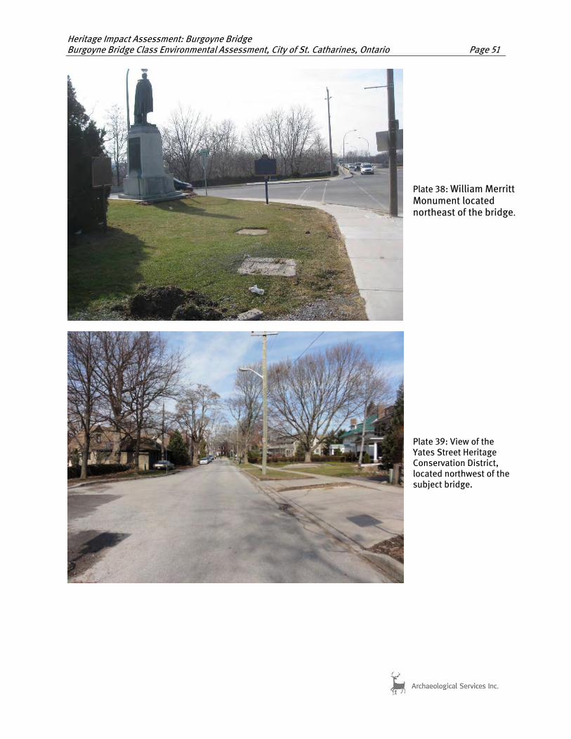
Heritage Impact Assessment: Burgoyne Bridge Burgoyne Bridge Class Environmental Assessment, City of St. Catharines, Ontario Page 51
Plate 38: William Merritt Monument located northeast of the bridge.
Plate 39: View of the Yates Street Heritage Conservation District, located northwest of the subject bridge.

Heritage Impact Assessment: Burgoyne Bridge Burgoyne Bridge Class Environmental Assessment, City of St. Catharines, Ontario Page 52
APPENDIX B:
Selected Bridge Drawings

Heritage Impact Assessment: Burgoyne Bridge Burgoyne Bridge Class Environmental Assessment, City of St. Catharines, Ontario Page 53

Heritage Impact Assessment: Burgoyne Bridge Burgoyne Bridge Class Environmental Assessment, City of St. Catharines, Ontario Page 54

Heritage Impact Assessment: Burgoyne Bridge Burgoyne Bridge Class Environmental Assessment, City of St. Catharines, Ontario Page 55

Heritage Impact Assessment: Burgoyne Bridge Burgoyne Bridge Class Environmental Assessment, City of St. Catharines, Ontario Page 56

Heritage Impact Assessment: Burgoyne Bridge Burgoyne Bridge Class Environmental Assessment, City of St. Catharines, Ontario Page 57

Heritage Impact Assessment: Burgoyne Bridge Burgoyne Bridge Class Environmental Assessment, City of St. Catharines, Ontario Page 58
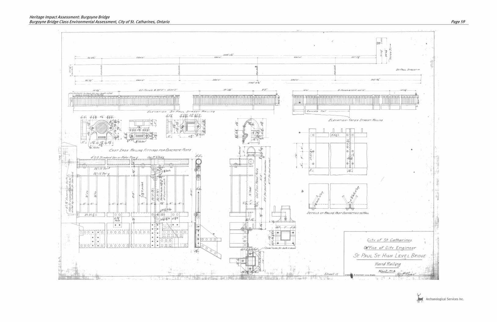
Heritage Impact Assessment: Burgoyne Bridge Burgoyne Bridge Class Environmental Assessment, City of St. Catharines, Ontario Page 59


![CITATION: Burgoyne v Bairstow - localcourt.nt.gov.au · CITATION: Burgoyne v Bairstow [2006] NTMC 097 PARTIES: ROBERT ROLAND BURGOYNE v CHAD BENJAMIN BAIRSTOW TITLE OF COURT: Court](https://img.dokumen.tips/doc/110x75/5ed71ebec30795314c173bf8/citation-burgoyne-v-bairstow-citation-burgoyne-v-bairstow-2006-ntmc-097-parties.jpg)