Embed Size (px)
Citation preview

U.S. Department of the InteriorBureau of Land Management FiNAL
Burns District, Oregon November 1985
__ -
. L.--
.-- ,-

IN REPLY REFER TO
United States Department of the InteriorBUREAU OF LAND MANAGEMENT
BURNS DISTRICT OFFICE74 S. Alvord Street
Burns, Oregon 97720
November 27, 1985
Dear Diamond Craters User :
The final Diamond Craters Recreation Management Plan has been completed and acopy is enclosed for your use.
This document outlines the management direction the Bureau of Land Managementwill be taking in the coming years for the Diamond Craters Outstanding NaturalArea.
These decisions are the result of written and personal public commentsreceived during the 30-day comment period on the draft document.
After another 30-day public review period from this publication date, thedecisions outlined in this final document will be implemented. All commentsshould be sent to the Burns District Manager, BLM, 74 S. Alvord St., Burns,Oregon 97720 by December 30 , 1985.
Thank you for your interest and support in BLM's Diamond Craters OutstandingNatural Area.
Sincerely yours,
WarburtonDistrict Manager

Recreation Area Management Final Plan for the Diamond CratersOutstanding Natural Area
Oregon
U.S. Department of the InteriorBureau of Land Management
Burns District, Oregon
Recommended byDavid E. Vickstrom, Outdoor Recreation Planner
Accepted byMalcolm T. Shrode, Three Rivers Resburce Area Manager
Approved by

DIAMOND CRATERS
VICINITY MAP
B u r e a u o f L a n d M a n a g e m e n t
B u r n s D i s t r i c t
O r e g o n
-French&m

Table of Contents
PagePART I - INTRODUCTION. . . . . . . . . . . . . . . . . . . . . . . . . . . . . . . . . . . . . . . . . . . . . . . . . . 1BACKGROUND . . . . . . . . . . . . . . . . . . . . . . . . . . . . . . . . . . . . . . . . . . . . . . . . . . . . . . . . . . 1
Purpose and Scope . . . . . . . . . . . . . . . . . . . . . . . . . . . . . . . . . . . . . . . . . . . . 1Relationship to Bureau Planning. . . . . . . . . . . . . . . . . . . . . . . . . . . . . . . . . . . 2Historical Perspective. . . . . . . . . . . . . . . . . . . . . . . . . . . . . . . . . . . . . . . . . . . . 1Recent Secretarial Actions. . . . . . . . . . . . . . . . . . . . . . . . . . . . . . . . . . . . . . . . 2
SETTING AND MULTIPLE RESOURCE VALUES . . . . . . . . . . . . . . . . . . . . . . . . . . . . . . . . 2
Location and Access . . . . . . . . . . . . . . . . . . . . . . . . . . . . . . . . . . . . . . . . . . . . 2Area Size and Ownership . . . . . . . . . . . . . . . . . . . . . . . . . . . . . . . . . . . . . . . . . 2Landscape Character .. : . . . . . . . . . . . . . . . . . . . . . . . . . . . . . . . . . . . . . . . . .Climate . . . . . . . . . . . . . . . . . . . . . . . . . . . . . . . . . . . . . . . . . . . . . . . . . . . . . . .Geology . . . . . . . . . . . . . . . . . . . . . . . . . . . . . . . . . . . . . . . . . . . . . . . . . . . . . . .t3~EE-ology.. . . . . . . . . . . . . . . . . . . . . . . . . . . . . . . . . . . . . . . . . . . . . . . . . . .
Miner&, ‘&I,’ &as; .&othermal.. ......................................................................Water . . . . . . . . . . . . . . . . . . . . . . . . . . . . . . . . . . . . . . . . . . . . . . . . . . . . . . . . .Vegetation . . . . . . . . . . . . . . . . . . . . . . . . . . . . . . . . . . . . . . . . . . . . . . . . . . . . .Wildlife.. . . . . . . . . . . . . . . . . . . . . . . . . . . . . . . . . . . . . . . . . . . . . . . . . . . . . .Cultural Resources . . . . . . . . . . . . . . . . . . . . . . . . . . . . . . . . . . . . . . . . . . . . . .Recreation/Natural Area Values. . . . . . . . . . . . . . . . . . . . . . . . 1 . . . . . . . . . . .Wilderness Study Areas. . . . . . . . . . . . . . . . . . . . . . . . . . . . . . . . . . . . . . . . . .Range (Livestock and Wild Horses) . . . . . . . . . . . . . . . . . . . . . . . . . . . . . . . .
USER PROFILE AND VISITATION ESTIMATES . . . . . . . . . . . . . . . . . . . . . . . . . . . . . . . . .
MAJOR ISSUES . . . . . . . . . . . . . . . . . .
PART II - MANAGEMENT OBJECTIVE
Management Objective . .
........................................
AND CONSTRAINTS. . . . . . . . . . . . . . . . . . . . . .
Management Constraints. . . . . . . . . . . . . . . . . . . . . . . . . . . . . . . . . . . . . . . . .
PART Ill - MANAGEMENT PLAN. . . . . . . . . . . . . . . . . . . . . . . . . . . . . . . . . . . . . . . . . . . . .
PART IV - IMPLEMENTATION PHASING AND COST ESTIMATES.. . . . . . . . . . . . . . . . .
PART V - APPENDICES . . . . . . . . . . . . . . . . . . . . . . . . . . . . . . . . . . . . . . . . . . . . . . . . . . .
Appendix A Planning Participants and Cooperators . . . . . . . . . . . . . . . . . . .Appendix B Applicable Federal, State Laws and Regulations. . . . . . . . . . . .Appendix C Management Program Alternatives. . . . . . . . . . . . . . . . . . . . . . .
6
8
9
i
IO
16
18
18
::Appendix D Writings of Interest. . . . . . . . . . . . . . . . . . . . . . . . . . . . . . . . . . . . 22

Part I-Introduction
Little Red Cone
Background
Purpose and ScopeThe purpose of this recreation plan is to identify specificactions and their sequence for implementation tomanage Diamond Craters as an Outstanding NaturalArea (ONA) and Area of Critical Environmental Concern(ACEC).
The scope of this issue-oriented document is limited toa discussion of those actions required to resolve issuesand utilize the opportunities available in the area. Detail-ed site planning and facility designing will be con-sidered following approval of the specific managementactions.
Relationship to Bureau PlanningDiamond Craters is a special management area iden-tified in the Drewsey Resource Area ManagementFramework Plan (now part of the Three Rivers ResourceArea) in the Burns District. Its designation as an ONAand as an ACEC is consistent with the District’s landuse recommendations and decisions.
Historical PerspectiveDiamond Craters were known to the early settlers ofeastern Oregon and were named about 1875 for theirproximity to the Diamond Ranch. This ranch took itsname from the diamond-shaped cattle brand used byMace McCoy, an early settler. The name Diamond wasalso given to a small community and post office nearby.
The main interest shown in the area was as a sourcefor cinders and building stone. The pahoehoe lava fromDiamond Craters has been used for construction sincethe late 1800’s. Many of the local roads and drivewaysare covered with Diamond Craters cinders. Numerousbuildings, including the well-known Round Barn, arefaced with slab lava from the Craters.
More recently thin slabs of basalt attracted the atten-tion of rock dealers who removed the lava withoutauthorization to sell for decorative facing stone. Thetrespasser’s heavy equipment shattered the pahoehoeto powder, which left permanent scars, while theremoval of the basalt destroyed features necessary forinterpretation of the geology. It was not until the mid1960’s that a significant number of educators andstudents became knowledgeable and concerned aboutthe natural resources of the Craters. Few realized whatoutstanding values it held. Courses offered at the
1

Malheur Field Station stimulated interest in DiamondCraters which led to the protective designations andmanagement direction followed today by the Bureau.
Recent Secretarial ActionsThe Bureau designated Diamond Craters as an Areaof Critical Environmental Concern on December 2,1980. This designation declared special managementattention be given to protect and prevent irreparabledamage to the geologic features and ecosystems of thearea.
Public Land Order 5822 withdrew 16,656.18 acres ofpublic lands on January 22, 1981, from the operationof the general land laws including the mining laws, butnot from leasing under the mineral leasing laws for theprotection and preservation of geologic and biologicalresources of exceptional scientific, educational, scenicand recreational values.
Diamond Craters was designated as an OutstandingNatural Area on April 1, 1982, under the generalcategory of Recreation Lands, which identifies landswhere recreation is expected to be a major use. AsClass IV Recreation Lands, Outstanding Natural Areasare “areas of outstanding scenic splendor, naturalwonder or scientific importance” that merit special at-tention and care in management to ensure their preser-vation in their natural condition.
Setting and MultipleResource Values
Location and AccessDiamond Craters is located near the center of HarneyCounty in southeast Oregon’s high desert country. Thearea lies about 40 air miles southeast of Burns inTownship 28 and 29 South, Range 32 East. It is remotefrom population centers but access is not difficult. Oneroute is southeast from Burns on Oregon State Highway78 to the junction at New Princeton, then south and westby well-marked all-weather roads that skirt the easternand southern parts of the Craters. Another route is southfrom Burns via Oregon State Highway 205 and Dia-mond Lane, a paved county road.
Area Size and OwnershipThe boundaries of the land for which this managementplan is written are the same as that delineated for theONA and ACEC designations. The area contains 16,656acres of public land adjoining the Malheur NationalWildlife Refuge on the southern and western boun-daries. The acreage may change as recommended landacquisitions occur to place additional parcels within theboundaries of the area.
Landscape CharacterThe most striking visual characteristic of this landscapeis the geologically recent volcanic activity. The exposed lava flows, vents, craters, and domes interspersecwith pockets of vegetation are the dominant features.The landform is gently rolling to nearly flat, interruptedby vents and craters that usually appear as depressionsrather than cones. The landform has no strong linearqualities. Course textured rock outcrops are frequent,as the vegetation has not developed to completely coverthe recent volcanic flows.
The dark colored volcanic rocks intermix with the tansand greens of the vegetation to create a subtle contrastin color and texture. Grasses and sagebrush are thecommon vegetative cover. Water is seldom visible in thelandscape.
ClimateSummers are hot and dry. Most of the precipitation fallsduring the cold winters and early spring; mean annualprecipitation varies between 6 and 16 inches. Sunshineoccurs approximately 225 days per year. Daily max-imum and minimum temperatures can be extreme dur-ing a single day and frosts may occur any night of theyear.
GeologyDiamond Craters is geologically unique in the UnitedStates. A great variety of basaltic igneous-volcanicstructures representing a complex series of geologicevents are present within a small geographic area.Preservation of volcanic features is excellent due to alack of erosion (Peterson and Groh, 1964). The unusualconcentration of igneous features is related to thegeologic environment occurring at the junction of theHigh Lava Plains Province and the Basin and RangeProvince at the time of volcanic activity.
The geology of the area illustrates a sequence of in-trusive, extrusive and pyroclastic igneous activityresulting in complex eruptions associated with unusuallocalized doming. These eruptions display the entirerange of explosive and collapse activity which can oc-cur in conjunction with basaltic volcanism, from ex-tremely fluid fissure-type eruptions to highly explosivemaar and caldera structures. Some of the individualfeatures are: a graben; domal structures; a caldera; amaar; craters and vents; cinder cones; spatter cones;driblet spires; kipukas; pahoehoe and aa flows;pressure ridges and collapse structures; lava toes; ashfall and cinder tephra with cored bombs; tensional frac-tures; surface flow features; and lava trenches, semi-trenches, and tubes with unusual lining formations. Thisarray of features has been called a museum of basalticvolcanism.
2

L E G E N D
- - B o u n d a r y o f O u t s t a n d i n g N a t u r a l A r e a MAP 1. . . E d g e o f D i a m o n d C r a t e r s F l o w s DIAMOND CRATERS
M a l h e u r N a t i o n a l W i l d l i f e R e f u g e U.S. DEPARTMENT OF THE INTERIOR
m BLM Lands Bureau of Land Management
n P r i v a t e L a n d s B u r n s D i s t r i c t
1 9 8 5
1 0 1 2 M I L E S

SpeleologyDiamond Craters contains a wide diversity of significantspeleological resources. Numerous caves have beendiscovered in the ONA, both in the domes and in theflank flows, and there is great potential for futurediscoveries (Anon., 1961; Larson, 1977; Benedict, 1980).Several caves contain unusual, if not rare, speleothems(i.e., cave formations) and linings. The flank flows ex-hibit every degree of collapse and roofing possible forpahoehoe lavas. A specialized subterranean mite issuspected to inhabit a 40 footdeep fissure in NortheastDome, but further studies are needed for verification.
SoilsMost soils are either Entisol (young) or Aridosol (arid)and were derived from fine tephra. They are coarse tex-tured, lack strong soil development, have a light col-ored profile and vary in depth from 20 inches to greaterthan 40 inches. They are neutral to slightly alkaline inpH. Near the southern and western edges, there aresmall inclusions of dark colored Mollisol (grassland)soils which have a silty texture and are poorly drained.
Minerals, Oil, Gas, GeothermalDiamond Craters is classified by the U.S. GeologicalSurvey as prospectively valuable for geothermal energy.Data quality is poor, but evidence indicates an area ofhigh heat flow with the possibility of a low temperaturegeothermal reservoir.
The U.S. Geological Survey has classified the DiamondCraters area as prospectively valuable for oil and gas.Very little exploration has occurred throughout theHarney Basin, so the actual potential is unknown.
No metallic minerals are known to occur at DiamondCraters. Their presence is unlikely within the types ofvolcanic materials forming the Diamond Cratersgeologic unit; they may occur in underlying formations.There has been some exploration for uranium in theHarney Basin. The primary non-metallic mineral com-modities present at Diamond Craters are basalt andbasaltic cinders. These occur in substantial quantitiesas rock suitable for crushing (for aggregate and roadsurfacing), cinders (for road surfacing), and slab lava(for building and veneer stone). Other non-metallic com-modities such as zeolites and saline brines may occurat depth.
Historical mineral production from Diamond Craters hasbeen low, limited to some use of cinders for road con-struction and small quantities of slab lava for buildingand veneer stone. The majority of use of these materialshas been local. Under ONA management, the cinderpits will be closed and the sites rehabilitated. Since1956, the area has also been withdrawn from mineralappropriation under the mining laws. Little interest hasbeen expressed in leasable minerals.
WaterAquatic zones constitute less than five percent of thearea. Malheur Maar, a spring-fed, permanent lake withinan explosion crater, is the only body of water of any sizewhich occurs within the interior of the Diamond Cratersflows. This lake is approximately 6 feet deep and 200feet in diameter; there are nearly 60 feet of sedimentsbeneath the water. White Lake lies at the northeasternedge of the flow and historically contained water inter-mittently. It has remained filled in recent years sincehigher than normal water runoff has become commonin southeastern Oregon. The remaining Wetlands areadjacent to the Refuge along the southern and westernedges of the flow; water levels are regulated by theRefuge.
VegetationDiamond Craters is located in the Northern Great Basinat elevations between 4150 and 4700 feet above sealevel. It occurs at the ecotones between the DesertShrub, the Shrub-Steppe and the Western Juniper-BigSagebrush Zones and contains both unusual andrepresentative species and communities of the Uplandsand the Wetlands. Over 240 species of vascular plantshave been identified.
Young cinder based soils support relatively undisturb-ed native bunchgrass communities of needle-and-thread grass (Stipa comata, S. thurberiana) andbluebunch wheatgrass (Agropyron spicatum). The shrubcommunity is dominated by big sage (Artemisia triden-tata), and occasionally rabbitbrush (Chrysothamnusviscidiflorus and C. nauseosus). Western juniper and bigsage (Juniperus occidentalis/Artemisia tridentata) forman open woodland community in the northern portionand at higher elevations. A small aspen grove (Populusfremuloides) borders the southern edge. The low eleva-tion of the stand is unusual in the Harney Basin.
WildlifeThe ONA provides a protected area where the geneticdiversity of the species in the central Harney Basin canbe maintained. The wide diversity of geologicalsubstrates and landforms in combination with the verydiverse vegetation, provides abundant nesting, restingand feeding habitats for wildlife, both vertebrates andinvertebrates. Raptors such as red-tail hawks, long-eared owls, great horned owls, screech owls, goldeneagles and prairie falcons nest on the crater ledges andin juniper trees. Fallen rocks in craters and near rockoutcroppings create ideal small hollows for turkeyvulture nests.
Nineteen species of amphibians and reptiles, 52species of mammals, and 189 species of birds areknown or suspected of occurring at Diamond Craters.To date, no rare or endangered species of animals areknown from the Craters. However, Gruber discovereda highly unusual mite inhabiting a deep fissure with per-
4

LOCATION OF SELECTED GEOLOGIC LANDFORMS AT DIAMOND CRATERS
Dry Maar A s p e n SprmgMalheur Maar Rutherford LakeMulbple Explosion Crater Cloverleaf CraterWestern Twn Crater Wmao Cave SvstermEastern Twm Crater N.&al Bndge.Nolf CraterBtg Cmder Crater
John Kelly’s Earth CrackHolsmger Cave
Deep Throat Rowan CraterRing spatter Cone Mossy CraterRed Bomb Crater Little Red ConeOval Crater Currant CraterKeyhole Crater Brown’s Craterspatter Cone Crater Spatter AreaLava Pit Crater Collapsed Trench SystemSurprw Pat Crater Cored BombsBacon Cave Collapse FeaturesBig Bomb Crater CWS
Gealogc feature
Structural dome
Fault
C%fe
MAP 2
DIAMOND CRATERSU.S. DEPARTMENT OF THE INTERIOR
Bureau of Land Management
B u r n s D i s t r i c t
1 9 8 5
1 0 1 2 M I L E S
5

manent ice in Northeast Dome -the fissure is 40 feetdeep, eight feet wide and several hundred feet long.Similar fissures in Arizona contain “cave adapted”i n v e r t e b r a t e s .
Several vertebrate species are included on variousOregon “lists of concern” (Storm, 1966; Marshall, 1969;Olterman and Verts, 1972; Stoel, 1978). For example,both the black-throated sparrow and the whiptail lizardoccur at Diamond Craters very near the northern limitsof their breeding range. Various raptors nest on basalticledges and in the juniper trees. Big-eared bats, whichare of special concern to many speleologists have beenobserved. Extensive field work is needed to determinethe true rarity of these species.
Since 1972, Diamond Craters has been used in at leastfour separate, ecological studies: pseudoscorpions(Benedict), long-eared owls (Johnstone), canyon mouse(Fisher and Cross, 1979), and the paleoecology of theGreat Basin (Aikens et al., 1978, 1979; Mehringer).McKenzie noted the presence of melanistic forms ofwestern fence lizards and Turner observed melanisticforms of small rodents. Herman observed canyon androck wrens nesting sympatrically in the same crater; thisrelationship has not been seen at other geographiclocations.
Cu It u ml ResourcesAlthough Diamond Craters isn’t known for its culturalresources, one or two lithic scatter sites have beendiscovered. Even more important, however, is the sedi-ment record deposited beneath the waters of MalheurMaar, a freshwater lake 200 feet in diameter and 6 feetdeep which is located in one of the explosion cratersof West Dome. Peter Mehringer, Jr., Department ofGeology and Anthropology, Washington State Univer-sity states:
Malheur Maar is the only low elevationdesert lake between Canada and Baja whichcontains an unbroken sedimentary columnwhich spans the past 6,000 years; the lakeis especially significant due to its rapid rateof deposition, its permanency and its loca-tion at the shadscale-sagebrush ecotone.
Mehringer and his graduate students, as part of theSteens Mountain Prehistory Project, have removed a15 meter core of sediments from Malheur Maar. Thecore from Malheur Maar and amber rat samples fromSurprise and Spatter Cone Caves, along with materialsfrom sites outside of Diamond Craters, are beingstudied in order to reconstruct the ecological history andthe movements of humans in the Great Basin since theend of the Pleistocene.
(a) the unique and/or scientific-educational values en-countered by users of Diamond Craters, and (b) thescientific investigations conducted there. Communica-tions and reprints are on file at the District Office. Thisdata gathering process reveals that Diamond Cratersis used as an outdoor classroom and laboratory byseveral thousand visitors per year who are interestedin basaltic volcanism, and/or intrigued by the survivalof biota in semi-arid environments. Visitors include fieldtrip groups touring the Refuge and Steens Mountain,students taking classes at the Malheur Field Station,scientists studying various problems, and localresidents with guests. Visitors are of every age groupand come not only from all parts of the United Statesbut from foreign countries.
A self-guided auto tour has been developed thathighlights outstanding natural features which can beseen when travelling by vehicle. There are numerousstops which the guide locates and interprets for the in-terested visitor.
Diamond Craters is managed under Visual ResourceManagement Class II, meaning that changes should notbe evident in the characteristic landscape.
Wilderness Studv AreasDiamond Craters lacks wilderness characteristics andwas eliminated from further Wilderness Review inMarch, 1980.
Range (Livestock and Wild Horses)Dome3ic fivestock was brought into southeasteinOregon around 1870 and by 1900 most of DiamondCraters was heavily grazed by horses, cattle, and sheep.In 1960, fenced seedings were developed to the northand no federal grazing preference is now assigned inthe Craters. In addition, grazing permits were eliminatedby the Diamond Community Allotment Agreement ofJuly 10, 1970, and wild horses were rounded up andremoved from the area in November, 1979. The allot-ment agreement does recognize trailing access byseveral local permittees.
User Profile and VisitorEstimates
No specific visitor use analysis has been made wheretraffic counters and on-site interviewing were utilizedto determine user characteristics and numbers. TheMalheur National Wildlife Refuge kept a questionnairefor several years and estimated about 20 percent of theirvisitors went to see Diamond Craters.
Recreation/Natural Area ValuesThe district has gathered data since 1972 concerning:

The 1978 figures for visitor use of the Malheur NationalWildlife Refuge totalled 37,866 with an estimated 7,533journeying to the craters. Visitors come not only fromall parts of Oregon, but from the rest of the UnitedStates and foreign countries (Pope, 1978). The MalheurField Station, under the sponsorship of Pacific Univer-sity, utilizes the area as an outdoor classroom. DiamondCraters is especially interesting to individuals studyingbasaltic volcanism and/or those intrigued by the sur-vival of biota in semi-arid environments. Present visitorsinclude field trip groups and sightseers touring theMalheur National Wildlife Refuge and other points ofinterest in the Northern Great Basin, students takingclasses at the Malheur Field Station and scientists stu-dying various problems. Scientists studying DiamondCraters include Dr. Bruce Nolf, a geologist at CentralOregon Community College, Dr. Ellen Benedict, aspeleologist at Portland State University, and Dr. PeterMehringer, Jr., a geologist/anthropologist at WashingtonState University.
The following table illustrates the estimated recreationvisits for Diamond Craters for the 10 year period1985-1995 using a 1.01 per cent annual increase from1978 through 1989 and a 1.09 percent annual increasefrom 1990 through 1995. No data is available forestimating visitor days during this period.
Table 2Diamond Craters Use ProjectionsYear Visitors Per Year1978 7,5001979 7,6001980 7,7001981 7,7501982 7,8501983 7,9001984 8.000
Future use by the public is expected to increase as Dia-mond Craters becomes better known. The land will con-tinue to be managed for its scientific, educational andscenic values. Recreational use will be compatible withpreserving the natural and scenic values.
The following table shows demand projections forrecreation activities in the Pacific Northwest based onprojection of participation by annual percentage in-creases. The recreation activity of sightseeing is usedto project visitation.
1985 8,1001986 8,1501987 8,2501988 8,3501989 8,4001990 8,5001991 8,6001992 8,7001993 8,8001994 8,9001995 9,000
Table 1Recreation Demand Projections
1977-1989 1990-2000Annual Avg. Annual Avg.% Increase % Increase
CampingDeveloped 1.28 2.76Dispersed 1.28 1.50
Picnicking 1 .Ol 1.17Fishing 1.15 1.90Hunting
Big Game 1.22 1.14Small Game .45 1.42Upland Game .45 1.42Waterfowl 1.48 1.25
Sightseeing 1 .Ol 1.09Watersports 1.15 1.15Wintersports 1.61 1.59Off-Road Vehicle .74 1.04
Smooth surface of Pahoehoe lava
Source: U.S Forest Service, An Assessment of the Forest and RangeLand Sltuatlon in the United States, January 1980
7

Major Issue
Successful planning and management can only beachieved by recognizing and resolving important issues.This section identifies the issue considered in Part III,The Management Plan.
Issue-Environmental Protectionand RehabilitationCommentDiamond Craters possesses resource values of nationalsignificance. The past damage to these resources, inaddition to increased recreation and educational use,has created a need to initiate measures to protect andrehabilitate Diamond Craters. The stages in the inten-sity and methods of management will require thoroughexamination before implementation.
C o n s i d e r a t i o n s
Acquisition/Easementsl Land Base Adjustments
Cultural Values0 Site Protection
Supervisionl Law Enforcement/Visitor Safetyl Visitor Use Monitoring0 Visitor Use Allocation System0 Public Information and Education Program
Administration0 Motorized Vehicle Use0 Special Use Permits0 Land and Mineral Entry
Facility Management0 Future Developments0 Facility Operation and Maintenance0 Signs Program
Area Accessl Existing Roadsl New Road Developmentl High Desert Trail Route/Other Trail Routes
PART II-MANAGEMENTOBJECTIVE AND CONSTRAINTS
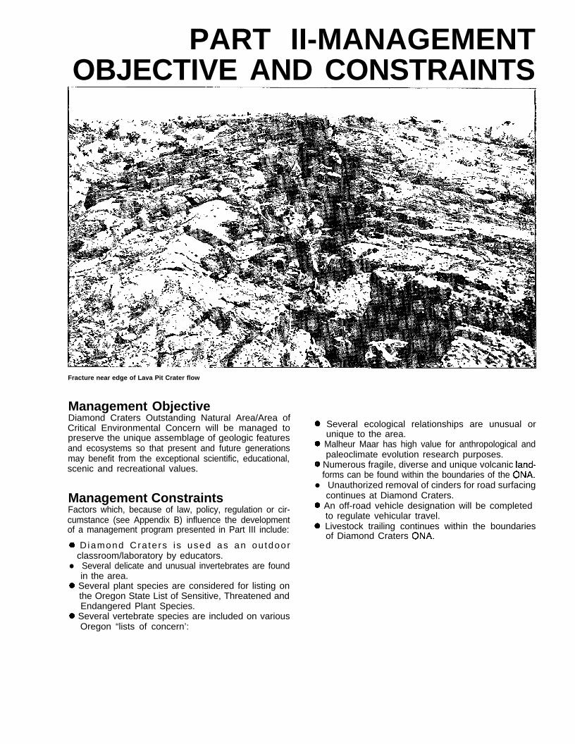
Fracture near edge of Lava Pit Crater flow
Management ObjectiveDiamond Craters Outstanding Natural Area/Area ofCritical Environmental Concern will be managed topreserve the unique assemblage of geologic featuresand ecosystems so that present and future generationsmay benefit from the exceptional scientific, educational,scenic and recreational values.
Management ConstraintsFactors which, because of law, policy, regulation or cir-cumstance (see Appendix B) influence the developmentof a management program presented in Part III include:
0 D iamond Cra te rs i s used as an ou tdoorclassroom/laboratory by educators.
l Several delicate and unusual invertebrates are foundin the area.
0 Several plant species are considered for listing onthe Oregon State List of Sensitive, Threatened andEndangered Plant Species.
0 Several vertebrate species are included on variousOregon “lists of concern’:
@ Several ecological relationships are unusual orunique to the area.
0 Malheur Maar has high value for anthropological andpaleoclimate evolution research purposes.
0 Numerous fragile, diverse and unique volcanic land-forms can be found within the boundaries of the ONA.
l Unauthorized removal of cinders for road surfacingcontinues at Diamond Craters.
0 An off-road vehicle designation will be completedto regulate vehicular travel.
0 Livestock trailing continues within the boundariesof Diamond Craters ONA.

Part 111The Management Plan
Driblet spire
The management plan involves 16 separate actions toresolve the issue and accomplish the management ob-jective. The identified issue discussed in Part I is listedalong with the planned management actions whichneed to be implemented. Alternatives to the actionsdiscussed in this section are presented in Appendix C.
Issue-EnvironmentaI Protec-tion and Rehabilitation
A. Acquisitions
Action A.l.-Land Base AdjustmentsInvolving Private LandsAcquire the following parcels of private land adjacentto the present boundaries of Diamond Craters ONA, ifthey become available. Adjustments can be throughland exchanges or by purchase.
(l)E%, Sec. 16, T. 28 S., R. 32 E.(2)W’/2NE’/4, NW%, N’/2SW1/4,
Sec. 36, T. 28 S., R. 32 E.(3)SEVSE%, Sec. 36, T. 28 S., R. 31 E.
DiscussionIf these private lands are offered for sale or exchangethe Bureau should actively seek to acquire them incooperation with the landowners. The parcels havelarge portions of the lava flow within their boundaries.A trail goes through Sec. 16 and a main county roadgoes through Sec. 36. Both provide access to fringesof the lava flow where adverse impacts are possiblethrough removal of materials, dumping and possibleleasing.
Action A/2.--Mineral Estate of Ex-changed State LandsAcquire mineral estate to WV2, Sec. 16, T. 28 S., R. 32E., and SEXNEX, NEXSE%, Sec.36, T.28S., R.31 E.
DiscussionThe west half of Section 16 is now under Bureau ad-ministration since recent completion of a land exchangewith the State of Oregon as is the SEXNEX and theNE%SE% of Section 36, T. 28 S., R. 31 E. However,since the mineral rights have been retained by the State,these areas are still subject to potential damage.
10
The boundaries of the Outstanding Natural Area canbe readjusted and noted in the Federal Register whenall proposed acquisitions are completed.
port should be given to the law enforcement agencies.
B. Cultural Values
A c t i o n C.2.-Recreational UseMonitoringMonitor the resource impacts of recreation use through:
Action B.l.-Cultural ResourceProtectionProtect cultural sites and where feasible, interpret forpublic information and education.
1.2.
DiscussionExecutive Order 11593 for “Protection and Enhance-ment of the Cultural Environment” documented in 36Federal Register 8921, May 13, 1971, directs Federalagencies to inventory their cultural resources and sub-mit to the National Register of Historic Places allqualified sites meeting the criteria to protect allnominated sites. The entire Diamond Craters has notbeen surveyed for cultural resources although apreliminary archaeological survey of one site was com-pleted in September, 1980. It is likely the Craters con-tains other archaeological sites as several sites havebeen reported on lands immediately adjacent to thearea’s boundary.
3.
4.
5.
6.
Periodic patrols by vehicle and foot.Locating traffic counters at strategic locations torecord visitors entering and leaving the area andusing specific sites.Recordation of group numbers and purposes forusing the ONA.Issuance of recreation use permits for specificrecreation, scientific study and education uses.Periodic visitor use analysis as visitor numbersand/or recreation uses change from the presentpattern.Photo points for caves and other sensitive featuresto establish a visual base-line to determinephysical changes and impacts.
Discussion
Subsistence/activity patterns of prehistoric people inDiamond Craters are at this time unknown. It is ap-parent that water sources in and adjacent to DiamondCraters were used by prehistoric tribes. It is also logicalto assume that the plant and animal resources whichmust have been present in prehistoric times were ex-ploited by these people.
Monitoring is essential to correlate use levels withresource condition and capacity and will precede anydecision for establishment of a recreation use alloca-tion system.
Action C.3.Visitor Use AllocationSystemAction Reserved. The current use level does not yetwarrant this.
C. Supervision Discussion
Action Cl .-Law Enforcement/Search and Rescue/Visitor SafetyContinue the cooperative law enforcement and searchand rescue agreement with the Harney County Sheriff’sDepartment to enforce regulations and provide visitorprotection. The Department patrols the area to detervandalism and guard against removal of slab lava andthe destruction of other natural resources. The agree-ment outlines the responsibilities of both agencies andthe amount and type of assistance each will provide inlaw enforcement situations. It should remain in forceas long as it is economically feasible and acts as aviable management tool.
A system to enforce visitor carrying capacities andallocate use among groups will not be implemented un-til monitoring indicates that visitor use is causing unac-ceptable resource damage, or measures are neededto minimize user conflicts. The principles for implemen-ting a recreation use allocation system will be developedin a national BLM policy expected at a future date.
Action C.4.-Public Information andEducation ProgramDevelop an interpretative program for users whichfocuses on:
1. Visitor awareness of outstanding natural, scenic andcultural resources.
DiscussionThe Bureau does not have the law enforcement orsearch and rescue capabilities in the form of trainedand experienced personnel to provide visitor andresource protection in the district. However, since BLMpersonnel are familiar with the area and BLM equip-ment may be most available, full cooperation and sup-
2. Environmentally acceptable visitor behavior whichwill protect cultural resources, wildlife habitat andpopulations, the natural character of the Craters andthe enjoyment of the area by recreationists.
3. Off-road vehicle use.
11

DiscussionProviding information about how visitors can best con-duct themselves could alleviate potential resource con-flicts, as well as the need for additional managementactions. These materials would also compliment themonitoring program.
D. Administration
Action D.l .-Motorized Vehicle UseAllow motorized vehicle use only on designated roadsby initiating an Off-Road Vehicle (ORV) designation andposting of the area.
DiscussionMuch of Diamond Craters is not conducive to vehicletravel because of rough terrain. A few roads have beenestablished in past years when the area was grazed bylivestock and cinder pits were established. Some sec-tions of these roads were constructed by bulldozers toprovide passage for vehicles.
Some of these roads can continue to be used formanagement, but others should be closed. An Off-RoadVehicle designation limiting vehicle use to specific roadswill enhance the ONA designation and provide protec-tion for the fragile natural features.
Action D.2.-Special Recreation UsePermitsRequire special recreation use permits for individualsand groups in those cases involving specific recreation,scientific study and education activities which affect therecreational use of the other visitors or have an impacton the area’s resource values. Fees may or may not becharged depending on the Bureau’s determination ofuse. Determination will be made on a case-by-casebasis with specific stipulations regulating use.
DiscussionSpecial recreation permits are issued for specificrecreational uses of the public lands and related waters.They are issued as a means to control visitor use, toprotect recreational resources, and as a mechanism toaccommodate commercial recreational uses. Authoriz-ed by the Land and Water Conservation Fund Act, thereare four types of uses for which these permits are re-quired - commercial, competitive, off-road vehicle useinvolving 50 or more vehicles, and individual or groupuse in special areas such as Diamond Craters.
Resource knowledge from inventories and research pro-jects conducted by field classes from various collegesand universities needs to be accessible to the Bureauas part of a permit stipulation. Educators and specializ-ed groups using the craters for projects will be requiredto have permits; thus the Bureau’s use data, resource
knowledge, locations and magnitude of projects can bekept current.
A permit system may also be utilized in the future forall groups to alleviate problems arising when they visitthe area during the same periods of time.
Action D.3.-Land and Mineral EntryRehabilitate areas where cinders and slab laba havebeen removed and review all future leasing and materialdisposal operations causing surface disturbance underthe most stringent interpretation of applicableregulations.
DiscussionThe surface disturbance associated with past cindermining and removal of slab lava are the most damag-ing activites that have occurred in the area. DiamondCraters has now been withdrawn from the operation ofthe general land laws, including the mining laws, butnot from leasing under the mineral leasing laws.
Cost and effect on the economics of any proposedoperation should not be a limiting factor in designingmitigation measures. The principle consideration shouldbe the protection and preservation of the land surfaceresources and air quality.
Some rehabilitative measures needed are sloping andfencing of disturbed areas, tearing down of miningmonuments and replacement of lava slabs to areaswhere they were removed.
Action D.4.Wild FireAdopt a policy of letting natural fire burn within theOutstanding Natural Area.
DiscussionAll fires will be controlled to prevent loss of human lifeor property within the ONA or to prevent the spread offires to areas outside the ONA where life or propertymay be threatened. The approved District Fire Manage-ment Plan will support methods of firefighting that donot allow the use of bulldozers or other heavy equip-ment for the building of firelines or roads within theboundaries of Diamond Craters. Since the majority ofthe area is lava flows, fires will be allowed to burn intothe flows and go out.
Prescribed burning and presuppression measures andtechniques may be allowed when necessary for the pro-tection of public health or safety. Both will be allowedonly in conformance with an approved Fire Manage-ment Plan which achieves the ONA objective with theminimum adverse impact on the resources. All fire con-trol activities such as temporary fire camps, helispots,
12

and other sites should not be placed within the boun-daries, if at all possible. Any such sites that are permit-ted shall be removed upon completion of use and theareas rehabilitated to as natural a state as possible.
E. Facility Management
Action E.l.-Future Developments
0 Develop a central information center.
DiscussionAn information/orientation center is needed wherevisitors can get information explaining resource valuesand recreational and educational opportunities. Materialsuch as maps, guidebooks and safety brochures shouldbe available for public use.
A campground could also be developed in the futureif visitors begin to stay longer than a few hours, as isthe present situation. At this time most visitors do notstay for a long enough period of time to justify the costof a campground or make it a viable management tool.
0 Provide interpretation using trailguides and brochureswith small on-site location markers rather than install-ing interpretive signs.
DiscussionUsing brochures and trailguides will require funding forperiodic reprinting of material. Trailguides also requirethe user to put more effort in following directions andreading information. In addition, there is the possibilityof vandalism and littering at information dispersalpoints. Moreover, the installation of signs at points ofinterest will be highly distracting in the Craters’ environ-ment and will require considerable upkeep andmaintenance.
l Develop parking areas or pull-outs at or near pointsof observation where vehicular parking space isneeded.
DiscussionControlled vehicular parking is necessary to avoid ran-dom parking along roadsides to protect the environmentand to promote visitor safety.
0 Maintain natural conditions at points of interest wherevisitor use and recreational developments could destroyor significantly alter resource values.
DiscussionPreservation and protection of the environment shouldreceive the highest priority when developments toenhance recreational uses are proposed. An example
of this is Malheur Maar which allows the public toseasonally observe muskrats, waterfowl, raptors, yellow-headed blackbirds and other wildlife when thesespecies utilize the pond.
There may be a time when user impacts become signifi-cant enough that leaving “as is” will be detrimental andsome development to mitigate the impacts will becomean issue. Then, a management decision such asclosure of a specific site or developments to mitigateimpacts will have to be made.
Action E.2.-Signs ProgramProvide minimum signing for essential services only,including traffic management, facility and recreation usemanagement, and the signing of the boundary aroundthe edge of the withdrawal.
DiscussionSigning, following a sign plan, is necessary for safety,providing direction and information and is essential forimplementing an interpretive program. However, em-phasis will be toward limiting sign numbers. See Ac-tion ll.A.4 for the features an interpretive programshould address.
E Area Access
Action F.l .-Existing Roads
e Maintain the road to Oliver Springs to allow safe travelof passenger cars.
@ Do not maintain the road to Little Red Cone but keepit at a low standard of construction to allow passage ofhigh clearance vehicles.
0 Close roads or trails that are not necessary formanagement of the area.
DiscussionLow standard roads are compatible with providingrecreation opportunities in a setting ranging from anessentially unmodified environment to one that isgenerally natural with moderate evidence of the sightsand sounds of man.
At times certain roads may be graded to allow passageof standard motor vehicle, but others should be allow-ed to revert back to a natural state or maintained as foottrails and no longer be available for vehicle use. Mostof these roads are on steep hillsides where erosioncaused by vehicles driven to the ridgetops is a problem.See Map 3 for roads that are designated to be openor closed to vehicle use.
13

Action F.2.-New Road DevelopmentDevelop no additional roads to allow motorized vehicleuse in Diamond Craters.
DiscussionIt would be impossible to maintain the natural resourcevalues in this fragile environment if the area is subjectedto continued manipulation justified by the need to pro-vide improved motorized vehicle access. The presentroad system is suitable to provide visitors needed ac-cess to view features and use the resources for scien-tific and educational purposes. Vehicle travel on theroad passing Keyhole Crater to Big Cinder Crater iscausing damage to the hillside. Realignment of the roadis not a feasible alternative as the same damage tonatural features that now exists would still continuebecause of the steepness of the terrain. Considerationwill be given to closing the road and converting it to ahiking trail if public sentiment favors this proposal.
Action F.3. --High Desert TrailRoute/Other TrailsAllow the proposed High Desert Trail to go through Dia-mond Craters. Also develop other trails to accommodateand enhance the recreation experience offered by thearea, while using the trails as a tool to provide protec-tion of fragile resources.
DiscussionThe Desert Trail is a recognized component of theOregon Recreation Trails System and eventually willbecome recognized nationally. This will draw attentionto this area and people from various walks of life willutilize the recreational values of Diamond Craters. Thisand other trails can help to guide people around orthrough areas of concern where natural values can beinterpreted, but protection is necessary. If trails are notdeveloped, it can be expected that random wanderingwill eventually create some irreparable damage.
14

ROADS & TRAILS
n Roads to be kept ape” lo vehicle travel
s Roads to be closed to all vehicle travel
0 0 0 Proposed Desert Trail Route
- Self-Guided Auto Tour
m DISTURBED AREAS
1 Abandoned Dump Sltes
2 Cmder Borrow PIIS
3 Slab Rock Trespass Area
LAND BASE ADJUSTMENTS. PRIVATE LANDS
MAP 3
DIAMOND CRATERS
U.S. DEPARTMENT OF THE INTERIORBureau of Land Management
B u r n s D i s t r i c t
1 9 8 5
0 1

PART IVIMPLEMENTATION, PHASING
AND COST ESTIMATES
Malheur Maar
The following Table 3 shows planned actions and costestimates for the recreation lands management pro-gram through fiscal year 1995. The actions discussedin Part III, The Management Plan, are scheduled for im-plementation during the IO-year period. While additionalplanning, survey and design and/or construction maybe necessary to fully implement some of the actions,others can be fulfilled with a minimum of preliminarywork. Cost estimates are not shown for some actionsas additional funding is not necessary for their im-plementation and continued management. Acquisitionof private land will most likely be completed through ex-change rather than purchase as current funding levelspreclude the opportunity for purchasing land by theBureau at this time.
The following summary of the total estimated fundingneeds is shown by fiscal year.
Fiscal Year Total Estimated ($)Funding Needs
1986 10,0001987 35,0001988 45,7001989 16,7001990 16,7001991 13,7001992 15,7001993 11,7001994 8,7001995 9,700
Total 183,600
16

Table 3 Planned Actions and Implementation Cost Estimates
Action
A.l. Land Base Adjustments/Private Lands
A.2. Mineral Estate ofExchanged State Lands
B.l. Cultural ResourceProtection
Cl. Law Enforcement/Search & Rescue/Visitor Safety
FY86 FY87 FY88 FY89 FY90 FY91 FY92 FY93 FY94 FY95
15,000 15,000
3,000
5,000
1,500 1,500 1,500 1,500 1,500 1,500 1,500 1,500 1,500 1,500
c.2.
c.3.
c.4.
Recreational UseMonitoring 4,500 4,500 5,500 4,500 4,500 4,500 5,500 4,500 4,500 4,500
Visitor UseAllocation System (Reserved) NO PROGRAMMED COST
Public information &Education Program 2,000 2,000 3,000 2,000 2,000 2,000 2,000 5,000 2,000 2,000
D.l.
D.2.
Motorized Vehicle Use 500 1,000 200 200 200 200 200 200 200 200
Special RecreationUse Permits
D.3. Land and MineralEntry
D.4.
E.l.
Wild Fires
Future DevelopmentsSurvey & DesignConstruction
E.2.
F.l .
Signs Program
Access-Existing
F.2. New Road Access
F.3. High Desert Trail/Other Trails
NO PROGRAMMED COST
NO PROGRAMMED COST
NO PROGRAMMED COST
4,5001 5 , 0 0 0 5 , 0 0 0
1,000 1 , 0 0 0 5 , 0 0 0 3,000 1,000
500 500 500 500 500 500 500
NO PROGRAMMED COST
5 , 0 0 0 5 , 0 0 0 5,000
1,000
500 500 500
FY ‘TOTALS 10,000 35,000 45,700 16,700 16,700 13,700 15,700 11,700 8,700 9,700 183,600
TotalEstimated
costs
30,000
3,000
5,000
15,000
47,000
24,000
3,100
4,50020,000
12,000
5,000
15,000
17

PART V - AP CES
Roofed tube on surface of lava flow
Appendix A-PlanningParticipants andCooperators
Management Participation
Joshua L. Warburton, District ManagerMalcolm T. Shrode, Three Rivers Resource
Area ManagerVictor E. Pritchard, Assistant District
Manager for Resources
Staff Participation
David E. Vickstrom, OutdoorRecreation Planner
Fred Taylor, Wildlife SpecialistGeoffrey L. Haskett, Realty SpecialistGeorge B. Brown, GeologistMark L. Armstrong, Supervisory Range
ConservationistTeresa M. Gibson, Public Affairs
Specialist
Other Agency and Interested GroupParticipation
BLM Burns Advisory BoardHarney County Planning CommissionDesert Trail AssociationPacific N.W. Natural Area CommilteeNatural Heritage Advisory CouncilNative Plant Society of OregonPublic Lands InstituteOregon Council of Rocks and Minerals ClubsAmerican Cave Conservation Association, Inc.Oregon Natural Heritage Database
18

Appendix t3Applicable Federal and State Laws andRegulations
9 Federal Land Policy and Management Act:Public Law 94-579: 94th Congress, October 21,1976;
0 43 Code of Federal Regulations: Subchapter B-Land Resource Management (2000); SubchapterH-Recreation Programs (8000);
0 Land and Water Conservation Fund Act of 1964,16 U.S.C. 460 l-l et. seq.;
0 Recreation and Public Purposes Act of 1926, 43U.S.C. 869 et. seq.;
0 National Environmental Policy Act of 1969, 42U.S.C. 4321;
0 Antiquities Act of 1906 (34 Stat. 225, 16 U.S.C.432, 433);
l Executive Order 11593, Protection and Enhance-ment of the Cultural Environment;
0 Executive Order 11644, Use of Off-RoadVehicles on Public Lands;
0 Secretarial Order No. 2924, Responsibility forPlanning the National Wild and Scenic RiversSystem and the National Trails System;
0 National Trail System Act of 1968, 16 U.S.C.1241 et. seq.;
l Public Land Administration Act, July 14, 1960(74 Stat. 506);
l Oregon Administrative Rules, Chapter 736, Divi-sion 40-State Parks and Recreation Division.
19

Appendix CManagement Program Alternatives
The management program presented in Part IIIresulted from an assessment of various alternativesto resolve identified issues. Alternatives consideredbut not included as part of the management pro-gram are listed below. For some actions, there areno alternatives which could be implemented toresolve issues within the framework of the statedmanagement objective.
Issue-Environmental Protectionand Rehabilitation
Action Al-Land Base Ad-justments Involving Private LandsAlternative-No Action. Private lands would remainalong the ONA boundary and portions of the lavaflow would not be protected. Some natural andcultural values may be altered or destroyed.
Action A.2.-Mineral Estate of Ex-changed State LandsAlternative-No Action. Acquired State landswould not be protected from mineral entry andsome natural and cultural values could be alteredor destroyed.
Action B. I, -Cultural ResourceProtectionAlternative-No viable alternative determined.
Action C. 1 .-Law Enforce-ment/Search and Rescue/VisitorSafetyAlternative-Develop no cooperative agreementsfor law enforcement or search and rescue but relyon State laws and a working relationship betweenthe Oregon State Police, the Harney CountySheriff’s Department and the BLM to handle situa-tions. This would work as long as lines of com-munications are kept open and county funds areavailable to make patrols.
Action C. 2. -Recreational UseMonitoringAlternative-Do not monitor recreation use. Unac-ceptable impacts on resources from public usecould continue for an undetermined length of time.
Action C. 3. -Visitor Use A/locationSystemAlternative-Reserved.
Action @.4.-Public Informationand Education ProgramAlternative-No viable alternatives determined.
Action D. I-Motorized Vehicle UseAlternative-Close Diamond Craters to any form ofmotorized vehicle use including all roads. Thiswould protect the resources, but would limit the useof the area by the public, scientists and educators.Leaving certain roads open and converting othersto foot trails should provide access and still give ahigh measure of protection.
Action D.2. -Special RecreationUse PermitsAlternative-Allow unregulated visitor use of theCraters. This could result in damage to natural andcultural resources through excessive and uncon-trolled use as well as increased conflicts betweengroups and loss of data and resource knowledge ofthe area.
Action D. 3.-Land and MineralEn tryAlternative-No viable alternative determined.
Action D.4.- Wild FiresAlternative-Continue fighting fire in DiamondCraters using traditional methods including theutilization of heavy equipment to build firelines androads. Impacts to resources would be considered,but fewer restrictions would be imposed to containand control fires.
Action E. 7. -Future DevelopmentsAlternative 1 -Develop an interpretive program us-ing interpretive signing rather than brochures &trailguides. Provide parking areas and informa-tion/orientation center as previously recommended.
Alternative 2-Develop no interpretive sites but letvisitors indentify and educate themselves to thenatural features by using the present auto tourguide and their own expertise and knowledge ofthe area. Visitors can continue obtaining the guidepamphlet from the Burns District Office.
20

Action E. 2. -Signs ProgramAlternative-No viable alternative determined.
Action F. L-Existing RoadsAlternative-Do not close any roads or trails tomotorized vehicles. Periodically maintain roads sovehicles can drive to points of interest such asKeyhole, Crater, Little Red Cone, and ShotgunSprings.
Action F.2.-New RoadDevelopmentAlternative-Develop vehicle access to features ofinterest if the terrain makes it feasible for road con-struction. A low number of roads would bedeveloped because so much of the area is not con-ducive to vehicle travel.
Action F.3.4iigh DesertTrail/Other TrailsAlternative-Do not develop any trails or delineateroutes to enhance the visitor’s experience, but letpeople hike over the lava flows as best they canwithout any specific direction.
Conflicts can arise with visitors using areas withspecial wildlife or plant needs. Routing backpackersthrough Diamond Craters is necessary to get hikersthrough the area and routed on to another point ofdestination. The Desert Trail encompasses thenatural border-to-border concept and DiamondCraters is only a small portion of the overall trailroute.
21

Appendix D-Writings ofInterest
Mehringer, Peter J., Jr.1985. Late-Quaternary pollen records from the in-terior Pacific Northwest and Northern Great Basinof the United States. In Pollen Records of Late-Quaternaty North American Sediments, V.A. Bryantand R.G. Holloway (eds.). American Association ofStratigraphic Palynologists, Dallas, Texas, pp.165-l 87.
Mehringer, Peter J., Jr. and Peter E. Wigand1985. Prehistoric distribution of western juniper. InProceedings of the Western Juniper ManagementShort Course, October 15-16, 1984, Bend, Oregon.Oregon State University Extension Service, Cor-vallis, Oregon, pp. l-9.
USDI-BLM1980. ACEC Plan Element, Burns District, Oregon.
USDI-BLM1978. Drewsey Management Framework Plan(MFP), Burns District, Oregon.
USDI-BLM1980. Diamond Craters Outstanding Natural Areaand Protective Withdrawal (OR 10676) Environmen-tal Assessment, Burns District, Oregon. A list of118 references can be found in this assessment.Also, the Appendix contains the following material:
Letter From Natural Area Preserves AdvisoryCommittee
Letter From the Pacific Northwest Natural AreaCommittee
Harter Speleological ReportTentative List of Vascular Plants Identified From
Diamond CratersTentative List of Amphibians and Reptiles Utilizing
Diamond CratersTentative List of Mammals Utilizing Diamond
CratersTentative List of Birds Utilizing Diamond CratersArcheological Report
Wigand, Peter E.1985. Diamond Pond, Harney County, Oregon: Manand marsh in the eastern Oregon Desert. Ph.D.Thesis. Washington State University, Pullman,Washington, 265 p.
22

UNITED STATES DEPARTMENT OF THE INTERIORBUREAU OF LAND MANAGEMENT
OREGON STATE OFFICEP.O. BOX 2965-825 NE MULTNOMAH STREET
PORTLAND, OREGON 97208
OFFICIAL BUSINESSPENALTY FOR PRIVATE USE, $3~30
AN EQUAL OPPORTUNITY EMPLOYER
IlllllPOSTAGE AND FEES PAID
DEPARTMENT OF THE INTERIOR
INT 415
BLM-OR-PT86-004-8000