Embed Size (px)
Citation preview

Bulletins Live! Two (BLT) TutorialBulletins Live! Two (BLT) is the Web-based application to access Endangered Species Protection
Bulletins (Bulletins). These Bulletins contain enforceable pesticide use limitations that are necessary to
ensure a pesticide's use will not harm a species listed as threatened or endangered (listed) under the
Endangered Species Act or their designated critical habitat.

This application runs most successfully using the following Internet browsers:
• Google Chrome
• Mozilla Firefox
• Safari
• Microsoft Edge
Please ensure that you are accessing BLT using one of the above browsers.
This tutorial explains the steps to use the BLT application, including a section with additional information.
The tutorial includes the following eight sections:
1. Using the map application tools
2. Identifying the intended pesticide application area (Step 1 on
Instructions Tab)
3. Selecting the application month (Step 2 on Instructions Tab)
4. Refining your search (Step 3 on Instructions Tab)
5. Selecting a PULA (Step 4 on Instructions Tab)
6. Printing a Bulletin (Step 4 on Instructions Tab)
7. Understanding the components of the PDF Bulletin
8. Additional information

Match the following letters for the tools with the letters onthe image.
1. Using the map application tools
A. Zoom Tool: Zoom in using the “+” button and zoom out using the “-”
button.
B. Previous View Tool: The left arrow will bring you to your previous view,
and the right arrow will bring you to a later view.
C. Full Map View Tool: Click the globe in the upper left hand corner to zoom
to the full extent of the Pesticide Use Limitation Areas (PULAs) on the map.
The geographic areas on the map where pesticide use limitations are present
are referred to as PULAs. A PULA is indicated on the map by a pink shape.
These are the geographic areas where pesticide use limitations exist to
protect listed species and their designated critical habitat.
D. Basemap Tool: Click the orange box in the upper right hand corner
labeled “Basemaps” to change the background.

Match the following letters for the tools with the letters onthe image.
1. Using the map application tools
E. Location Search Tool: Enter search criteria where it says “Find address or
place” by the magnifying glass to automatically zoom to an intended pesticide
application area. Options include but are not limited to: city, county, landmark,
zip code, full address, or coordinates (latitude and longitude: type longitude first,
then latitude) in decimal degrees (Examples include: New York, NY; New York
County, NY; Statue of Liberty, NY; 10004; Statue of Liberty National Monument,
Liberty Island, New York, NY 10004; -74.0444, 40.6892).
F. Opacity Slider: Use the opacity slider to increase or decrease the shading
intensity of the PULA(s).
G. Map Layer: Visible map layers can be turned on and off by clicking the check
mark to the left of the layer name. The map layer box can be minimized by
clicking the double arrow in the upper right corner of the box.

2. Identifying the intended pesticide applicationarea (Step 1 on Instructions Tab)
There are three ways to zoom to your intended pesticide application area:
A. Manually zoom to a location by dragging the map to your location and using the
“+” and “-” buttons in the upper left corner to zoom in and out.
B. Use the location search tool in the upper right corner to automatically zoom to
the location of your intended pesticide application. Search options include but
are not limited to:
• city (e.g., New York, NY)
• county (e.g., New York County, NY)
• landmark (e.g., Statue of Liberty, NY)
• zip code (e.g., 10004)
• full address (e.g., Statue of Liberty National Monument, Liberty Island,
New York, NY 10004) or
• coordinates (latitude and longitude: type longitude first, then latitude) in
decimal degrees (e.g., -74.0444, 40.6892).
Names of cities, counties or other landmarks may occur in more than one
location across the country; therefore, adding unique identifiers such as the
state will help the application find the correct location.

2. Identifying the intended pesticide applicationarea (Step 1 on Instructions Tab)
There are three ways to zoom to your intended pesticide application area:
C. Use the “lasso” function by holding the “Shift” button down and using the
mouse to draw a box around the intended application area.

3. Selecting the application month (Step 2 on Instructions Tab)
After zooming to your intended application area, you must select the
month when you intend to make your pesticide application from the
first drop down menu on the Instructions Tab. Bulletins are available
for the current month (default option) as well as the next six (6)
months.

4. Refining your search (Step 3 on Instructions Tab)
The default search is for all active ingredients and all products. However,
you may choose to further refine your search by entering any of the
following identifiers:
• Active ingredient
• Product name
• Product registration number
After entering your selected identifier, or the default options, click the
orange “Search” button at the bottom of the Instructions Tab.

4. Refining your search (Step 3 on Instructions Tab)
Active ingredient searches: You can type the name of your active
ingredient in the active ingredient search box or type the first couple of
letters of the chemical name and use the arrows on your keyboard or your
mouse to scroll through the list of active ingredients. Once you have
selected your active ingredient, click the orange “Search” button to view
the PULA(s) for this active ingredient.
• Active ingredient results will be for a suite of products containing that
active ingredient. To verify that your product is included in the suite,
you can use the product name or product registration number search.
• When searching for a specific active ingredient, only that active
ingredient and no product name will be available in the Pesticide Use
Limitation Summary Table.

4. Refining your search (Step 3 on Instructions Tab)
Product name searches: Begin typing the product name in the product name search box,
after typing the first three letters a drop-down list will appear. The format will be the product
name followed by the product registration number in brackets:
Click on a product from this list to select it, and then click the orange “Search” button to
view the PULAs for this product.
• If multiple products are assigned a single product registration number, you can use the
product name to identify the correct product.
• When searching for a specific product registration number, only the product name and
not the active ingredient will be available in the Pesticide Use Limitation Summary
Table.

4. Refining your search (Step 3 on Instructions Tab)
Product registration number searches: After typing the product registration number, a
drop-down list will auto-populate with the product name:
Click on a product from this list to select it, and then click the orange “Search” button to
view the PULAs for this product.
If multiple products are assigned a single product registration number, you can use the
product name to identify the correct product.
When searching for a specific product registration number, only the product name and not
the active ingredient will be available in the Pesticide Use Limitation Summary Table.

4. Refining your search (Step 3 on Instructions Tab)
Default search - all active ingredients and all products: Leaving the default “All”
in the active ingredient search box, and the product name and product registration
number search boxes blank will result in a search of all active ingredients and all
products for the intended pesticide application area. Click the orange “Search”
button to view the PULAs for all active ingredients and products.
• When using the default setting, both the active ingredient(s) and the product
name(s) will be provided in the Pesticide Use Limitation Summary Table.

5. Selecting a PULA (Step 4 on Instructions Tab) If a PULA occurs within your intended pesticide application area:
If a PULA occurs within your intended pesticide application area, select the
PULA by clicking on it. This will outline the selected PULA in yellow and
activate the Results Tab
The Results Tab will display the Pesticide Use Limitation Summary Table
and the Codes and Limitations Table for the selected PULA.

5. Selecting a PULA (Step 4 on Instructions Tab) If no PULAs occur within your intended pesticide application area:
If there are no PULAs within your intended pesticide application area, click the
orange “Search” button to generate the
“No Limitations” dialog box, stating that there are no limitations within the
user-selected map view.

6. Printing a Bulletin (Step 4 on Instructions Tab)If a PULA occurs within your intended pesticide application area:
Click the “Printable Bulletin” button at the bottom of the Results Tab to print or
save a PDF version of the Bulletin.
If no PULAs occur within your intended pesticide application area:
Click the “Printable Bulletin” button within the “No Limitations” dialog box to
print or save a PDF version of the Bulletin
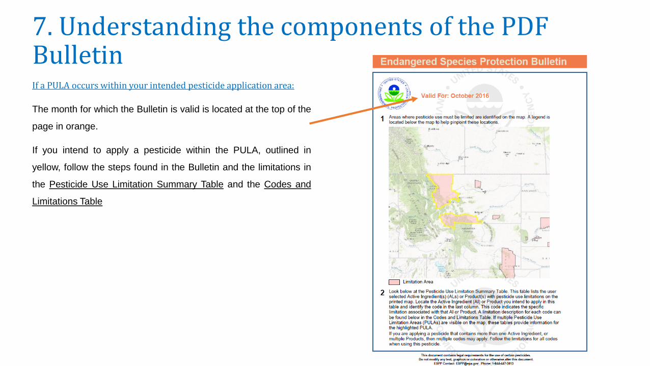
7. Understanding the components of the PDF BulletinIf a PULA occurs within your intended pesticide application area:
The month for which the Bulletin is valid is located at the top of the
page in orange.
If you intend to apply a pesticide within the PULA, outlined in
yellow, follow the steps found in the Bulletin and the limitations in
the Pesticide Use Limitation Summary Table and the Codes and
Limitations Table

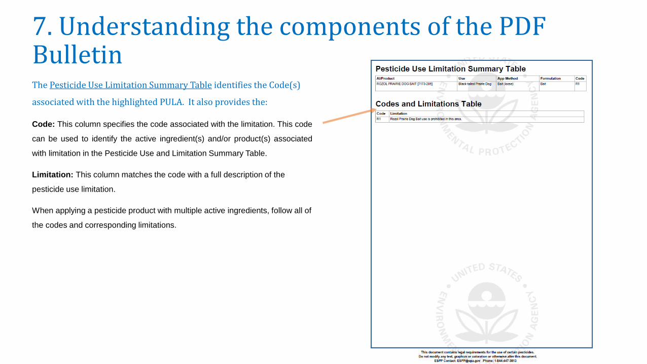
7. Understanding the components of the PDF BulletinThe Pesticide Use Limitation Summary Table identifies the Code(s)
associated with the highlighted PULA. It also provides the:
AI/Product: This column includes the name of the activeingredient(s) and/or product(s) with pesticide use limitations.
• When searching by active ingredient, only the active ingredientwill be visible in the Pesticide Use Limitation Summary Table.
• When searching by product name or product registration number,only the product name will be visible in the Pesticide UseLimitation Summary Table
-When using the default search settings, both the activeingredient(s) and product name(s) will be visible in the Pesticide UseLimitation Summary Table, as seen in the example above.

7. Understanding the components of the PDF BulletinThe Pesticide Use Limitation Summary Table identifies the Code(s)
associated with the highlighted PULA. It also provides the:
Use: This column specifies the labeled use pattern or use(s) to which thelimitation applies. The use may be specific (e.g., ‘cranberries’) or general, ifreferring to all use patterns registered for a particular product (e.g., ‘Any Use’).
App Method: This column specifies the application method (e.g., aerial spray,ground spray, seed treatment, bait, broadcast, etc.) associated with thelimitation.
Formulation: This column specifies the chemical formulation (e.g., bait, dust,ear tag, liquid, granular, etc.) associated with the limitation.
Code: This column specifies the code associated with the limitation. This codecan be used to identify the active ingredient(s) and/or product(s) associated withlimitation in the Pesticide Use and Limitation Summary Table.
Limitation: This column matches the code with a full description of the pesticideuse limitation.
When applying a pesticide product with multiple active ingredients, follow all ofthe codes and corresponding limitations.
7. Understanding the components of the PDF BulletinThe Pesticide Use Limitation Summary Table identifies the Code(s)
associated with the highlighted PULA. It also provides the:
Code: This column specifies the code associated with the limitation. This code
can be used to identify the active ingredient(s) and/or product(s) associated
with limitation in the Pesticide Use and Limitation Summary Table.
Limitation: This column matches the code with a full description of the
pesticide use limitation.
When applying a pesticide product with multiple active ingredients, follow all of
the codes and corresponding limitations.

7. Understanding the components of the PDF BulletinIf no PULAs occur within your intended pesticide application area:
The month for which the Bulletin is valid is located at the top of the page in
orange.
If there are no PULAs within the intended application area, no pink-shaded use
limitation areas will appear on the map.
If this occurs, there are currently no pesticide use limitations in place to protect
listed species at this location for the month indicated at the top of the Bulletin.

8. Additional Information:The geographic area where a pesticide use limitation is present to protect listed species and their designated critical habitat is referred to as a Pesticide Use
Limitation Area (PULA).
Each PULA is relevant for the pesticide active ingredient(s) and product(s) specified for that area. The search tools in the BLT application can be used to
view specific active ingredients and/or products associated with a given PULA for the intended application area specified in the user-defined search.
Limitation information can be found in the Pesticide Use Limitation Summary Table and the Codes and Limitations Table on the Results Tab within the
application and on the PDF version of the Bulletin.

8. Additional Information:Using the Location Search Toolbar: You can automatically zoom to an
intended pesticide application area, using the Location Search Toolbar.
Common search criteria include a city (e.g., New York, NY), county (e.g., New
York County, NY), landmark (e.g., Statue of Liberty, NY), zip code, (e.g., 10004),
full address (e.g., Statue of Liberty National Monument, Liberty Island, New
York, NY 10004) or coordinates (latitude and longitude: type longitude first, then
latitude) in decimal degrees (e.g., -74.0444, 40.6892). These search criteria can
be seen if you hover your mouse over the Location Search Toolbar.
Names of cities, counties or other landmarks may occur in more than one
location across the country; therefore, adding unique identifiers such as the
state will help the application find the correct location.


![[BLT] 지식재산권 기초강의](https://img.dokumen.tips/doc/110x75/557ef825d8b42ad17d8b5064/blt-557ef825d8b42ad17d8b5064.jpg)
![[BLT] patentKO.com v2.0](https://img.dokumen.tips/doc/110x75/54152e158d7f72356c8b458a/blt-patentkocom-v20.jpg)
![[Blt] 2014년 정부지원사업12월](https://img.dokumen.tips/doc/110x75/559cebdc1a28ab2b708b4788/blt-2014-12.jpg)
![[BLT] 특허문헌및선행기술조사_김성현_20160824_v2](https://img.dokumen.tips/doc/110x75/589e54581a28ab1c7f8b6b4b/blt-20160824v2-590f29da66f7b.jpg)


![[BLT] 인공지능, 딥러닝 특허 전략 v1.1 (170320 BLT 토크콘서트)](https://img.dokumen.tips/doc/110x75/58e648441a28ab1b438b4791/blt-v11-170320-blt-.jpg)
![[BLT] 6HA 발명기법](https://img.dokumen.tips/doc/110x75/559af70b1a28ab8c458b45cf/blt-6ha--559c094e2d7ea.jpg)

![[Blt] 2014년 정부지원사업11월](https://img.dokumen.tips/doc/110x75/5592e5c81a28ab33698b4637/blt-2014-11.jpg)
![[Blt] 2014년 정부지원사업10월](https://img.dokumen.tips/doc/110x75/558e65901a28ab92218b458e/blt-2014-10.jpg)


![[BLT] 브랜드 네이밍 사례 - BLT 브랜드 네이밍 연구소 (엄정한 변리사)](https://img.dokumen.tips/doc/110x75/58a3fc3b1a28ab64528b57fd/blt-blt-.jpg)