Embed Size (px)
Citation preview

Connecticut CollegeDigital Commons @ Connecticut College
Bulletins Connecticut College Arboretum
2013
Bulletin No. 41: Trap Rock Ridges of Connecticut:Natural History and Land UsePenelope C. Sharp
Ralph S. Lewis
David L. Wagner
Cara Lee
Follow this and additional works at: http://digitalcommons.conncoll.edu/arbbulletins
Part of the Geology Commons
This Article is brought to you for free and open access by the Connecticut College Arboretum at Digital Commons @ Connecticut College. It has beenaccepted for inclusion in Bulletins by an authorized administrator of Digital Commons @ Connecticut College. For more information, please [email protected] views expressed in this paper are solely those of the author.
Recommended CitationSharp, Penelope C.; Lewis, Ralph S.; Wagner, David L.; and Lee, Cara, "Bulletin No. 41: Trap Rock Ridges of Connecticut: NaturalHistory and Land Use" (2013). Bulletins. Paper 41.http://digitalcommons.conncoll.edu/arbbulletins/41

TRAP ROCK RIDGES of CONNECTICUT
Natural History & Land Use
Penelope C. Sharp with Ralph S. Lewis, David L. Wagner and Cara Lee
The Connecticut College ArboretumBulletin 41
and
Department of Energy and Environmental ProtectionState Geological and Natural History Survey of ConnecticutSpecial Publications 3

The Honorable Dannel P. Malloy, GovernorState of Connecticut
Daniel C. Esty, CommissionerDepartment of Energy and Environmental Protection
Steven O. Fish, DirectorOffice of Information Management
Margaret A. Thomas, Connecticut State Geologist
CONNECTICUT COLLEGE
Pamela D. Zilly ’75, Chair, Connecticut College Board of Trustees
Leo I. Higdon, Jr., President
Roger L. Brooks, Dean of the Faculty
Glenn D. Dreyer MA’83, Charles and Sarah P. Becker ’27 DirectorConnecticut College Arboretum

TRAP ROCK RIDGES of CONNECTICUT
Natural History & Land Use
Penelope C. Sharp
with
Ralph S. Lewis
David L. Wagner
Cara Lee
Illustrations by Janet Zeh
The Connecticut College ArboretumBulletin 41
and
Department of Energy and Environmental ProtectionState Geological and Natural History Survey of Connecticut
Special Publications 3

NOTICE to LIBRARIANS
This is the 41st volume of a series of bulletins published by the Connecticut College Arboretum, formerly named the Connecticut Arboretum. This is also the 3rd volume in the Special Publications series of the State Geological and Natural History Survey of Connecticut, Department of Energy and Environmental Protection.
Cataloging Information: Sharp, Penelope C., Ralph S. Lewis, David L. Wagner, Cara Lee. Trap Rock Ridges of Connecticut. Natural History & Land Use. Connecticut Col-lege Arboretum Bulletin No. 41. 2013, and State Geological and Natural History Survey of Connecticut, Special Publications 3, 2013
Published by the Connecticut College Arboretum, Box 5201 Connecticut College, 270 Mohegan Avenue, New London, CT 06320-4196, and the State Geological and Natural History Survey of Connecticut, Department of Energy and Environmental Protection, 79 Elm Street, Hartford, CT 06106-5127
http://arboretum.conncoll.edu www.ct.gov/deep/geology
ISBN 978-0-942081-20-0
Publication Availability
Department of Energy and Environmental Protection Store 79 Elm Street, Hartford, CT 06106-5127 www.ctdeepstore.com860-424-3555
Connecticut College Arboretum270 Mohegan AvenueNew London, CT 06375http://arboretum.conncoll.edu860-439-5020

CONTENTS
Foreword . . . . . . . . . . . . . . . . . . . . . . . . . . . . . . . . . . iv
Preface . . . . . . . . . . . . . . . . . . . . . . . . . . . . . . . . . . . v
Introduction . . . . . . . . . . . . . . . . . . . . . . . . . . . . . . . . 1
Geology of Trap Rock Ridges . . . . . . . . . . . . . . . . . . . . . . . 5
Ecology of Trap Rock Ridges. . . . . . . . . . . . . . . . . . . . . . . 12
Vegetation Communities of Trap Rock Ridges . . . . . . . . . . . . 14
Ice in Summer. . . . . . . . . . . . . . . . . . . . . . . . . . . . . 21
Wildlife on the Trap Rock Ridges. . . . . . . . . . . . . . . . . . . 22 Insects . . . . . . . . . . . . . . . . . . . . . . . . . . . . . . . 23 Reptiles and Amphibians . . . . . . . . . . . . . . . . . . . . . . 27 Birds . . . . . . . . . . . . . . . . . . . . . . . . . . . . . . . . 31 Mammals . . . . . . . . . . . . . . . . . . . . . . . . . . . . . . 33 Invasive Species of Trap Rock Ridges . . . . . . . . . . . . . . . . . 35
Land Use . . . . . . . . . . . . . . . . . . . . . . . . . . . . . . . . . 38
Quarrying the Trap Rock . . . . . . . . . . . . . . . . . . . . . . . 38
Recreation on Trap Rock Ridges . . . . . . . . . . . . . . . . . . . 41
History in High Places . . . . . . . . . . . . . . . . . . . . . . . . 43
Management . . . . . . . . . . . . . . . . . . . . . . . . . . . . . 45
Glossary . . . . . . . . . . . . . . . . . . . . . . . . . . . . . . . . . 48
References . . . . . . . . . . . . . . . . . . . . . . . . . . . . . . . . 51
About the Authors . . . . . . . . . . . . . . . . . . . . . . . . . . . . 53
Index . . . . . . . . . . . . . . . . . . . . . . . . . . . . . . . . . . . 55
iv
FOREWORD
THIS BOOK has been in the making for at least 15 years; in fact it was almost pub-lished in 2002 by the Connecticut Department of Environmental Protection. The text was in nearly final form and illustrations were gathered, but personnel changes and reorganizations within the department put the project on hold. Ralph Lewis, former state geologist and one of this publication’s authors, brought the manuscript to my at-tention. Having known Penni Sharp through the Connecticut Botanical Society for many years, I realized this would be a high-quality educational product in keeping with Arboretum publication standards. The authors and I have taken the last year to be sure the information is up to date and, to look on the bright side, during this publication’s long dormant period, color printing has become more affordable.
Trap rock ridges are surely one of Connecticut’s most distinctive physiographic fea-tures, along with Long Island Sound and the great Connecticut River. Drawing on the expertise of top-notch scientists and naturalists from around the state, this book follows a pattern established in Arboretum Bulletins 34 and 37, which focused in a holistic way on tidal marshes of Long Island Sound and the Connecticut River, respectively. Each of these provided introductions to the geology, plants, animals, human uses, management of and threats to large-scale, distinctive natural features of our state. Also like this bul-letin, the previous two resulted from collaborations with colleagues in the Connecticut Department of Energy and Environmental Protection. The intended audience includes high school and college students, naturalists, environmental consultants, and anyone curious about Connecticut’s natural history and the impact of human activities on natural areas. While a start has been made in characterizing and protecting trap rock ridges, it is my hope that this publication sparks additional exploration and protection of these unique and irreplaceable natural assets.
In addition to those individuals acknowledged in the Preface, I want to extend per-sonal thanks to Janet Zeh, who produced all the illustrations used in this project, and to Susan Lindberg, whose design skill turned it into a beautiful book.
Glenn D. DreyerCharles & Sarah P. Becker ’27 DirectorConnecticut College Arboretum
v
PREFACE
IT HAS BEEN NEARLY THREE DECADES since the publication of Cara Lee’s informative booklet West Rock to the Barndoor Hills. During these intervening years, our knowledge regarding the flora and fauna associated with the unique habitats of the ridges has grown considerably. It is thus entirely appropriate that a new version of the booklet be published by the Connecticut College Arboretum and the Connecti-cut Department of Energy and Environmental Protection. Although the reader will find many differences between this twenty-first-century edition of the booklet and its predecessor, there are also some striking similarities. The early history of the ridges as described by Lee has changed little. Since the publication of the original manuscript, a new awareness of the intrinsic values of trap rock ridges has arisen. This awareness has produced a legislative act that affords some protection to the ridges. Some of the com-munities where trap rock ridges are located have taken steps to ensure the protection of these special areas. These steps include such measures as land acquisition or amend-ments to local land regulations.
For naturalists, both amateur and professional, the ridges have much to offer. One can find the warm microclimates that support southern plant species such as the pale corydalis (Corydalis flavula) within a short distance of cold-air microclimates contain-ing northern species such as mountain ash (Sorbus americana), dwarf dogwood (Cham-aepericlymenum canadensis), or mountain maple (Acer spicatum). Rare butterflies found nowhere else within the state may be found along the ridgetops, and there is no better vantage point than an open ridge summit from which to spot hawks riding the thermals.
I consider myself fortunate to live at the base of one of Connecticut’s trap rock ridges, Totoket Mountain. Because of its proximity and the presence of some of Con-necticut’s blue-blazed trails nearby, I have spent countless hours rambling on the ridges. I have found much to discover in what I consider a naturalist’s Eden so close to my own backyard. Many of my observations are included in the following pages, as are the ob-servations and insights of scientists who have studied life on the ridges and contributed to today’s knowledge regarding these habitats. Throughout all seasons of the year, the ridges are places of interest. Trap rock ridges add greatly to the richness and diversity of the state’s natural environment. They deserve our attention.
It has been difficult throughout to address both a professional and a non-scientific audience simultaneously. I hope this booklet will be useful to both and will entice the reader to become better acquainted with one of Connecticut’s great natural treasures. Terms that may be unfamiliar to the non-specialist are printed in bold letters and appear in the glossary at the end of this book. Scientific names of plants are from Arthur Haines’ Flora Nova Angliae (2011).
ACKNOWLEDGEMENTS
This book could not have been written without the guidance and encouragement of many individuals. I am most grateful to Cara Lee, author of West Rock to the Barndoor Hills: The Traprock Ridges of Connecticut. Her book, now out of print, provided the

vi
inspiration for this new edition, and the majority of the text for the Land Use chapter. Former State Geologist Ralph S. Lewis of the Connecticut Geological and Natural His-tory Survey authored the geology section and provided continual encouragement from the initial stages of the project until the completion of the final draft of the manuscript. I am deeply grateful to David L. Wagner, professor in the Department of Ecology and Evolutionary Biology at the University of Connecticut, who wrote the insects section. Special thanks are extended to Kenneth J. Metzler, formerly with the Connecticut Geological and Natural History Survey, who gave generously of his time in reviewing the natural history portions of the book and in sharing his knowledge and expertise on the plant communities of Connecticut. Thanks also to Michael W. Klemens for his comments and input on the reptiles and amphibians of trap rock ridges; to William H. Moorhead, who provided valuable insights regarding plant life on the ridges; and to the late Leslie J. Mehrhoff, formerly of the G.S. Torrey Herbarium, for providing climato-logical information. I also extend my thanks to my friend Erin O’Hare, who read the manuscript most thoroughly and provided many valuable comments. Finally, I would like to extend thanks to Glenn Dreyer for his willingness to resurrect this manuscript and shepherd it into printed form. I am grateful to both Glenn and Connecticut Col-lege for their support of our endeavors.
Penni Sharp

1
INTRODUCTION
THE CONNECTICUT LANDSCAPE is distinctive owing to its clear division into three parts: the Western Uplands, the Central or Connecticut Valley, and the Eastern Uplands. Rising up from the floor of the Central Valley are a series of low mountains, the trap rock ridges. Trappa is the Swedish word for step, and the name “trap rock” thus describes the step-like appearance of the weathered rock faces of these unique landscape features, which are easily viewed from some of our state highways. Higby Mountain, Lamentation Mountain, and the Hanging Hills of Meriden are all readily seen from Interstate 91, as is East Rock in New Haven. The southern end of Saltonstall Ridge can be viewed from Interstate 95 in East Haven. From the summits of the ridges, one can see for miles.
These mountains may pale in height when compared to other ranges in New England or the Appalachians; however, their geologic and natural histories are fas-cinating and provide compelling reasons for further study. Through complicated geologic processes and over eons of time, the ridges have evolved to form the bold escarpments that we see today. Their bedrock composition has provided the parent material for rich mineral soils. These rich soils, in combination with climatic factors, gave rise to a variety of natural habitats and their associated plant communities, and these are home to a number of rare plants and animals that are found nowhere else in Connecticut.
“Saving the ridges would be an act of imagination, but what is at stake is close to Connecticut’s identity, and once gone is without price.” So stated William H. Whyte in his 1962 report to Governor John Dempsey, Connecticut’s Natural Resources: A
Beseck Mountain, Middlefield (Janet Stone)

2
Proposal for Action. In the report, Whyte recommended that the state acquire be-tween 50,000 and 80,000 ridgeline acres by either direct purchase or gift. Although some portions of trap rock ridges are now in state ownership, many remain in private hands where the possibility of development continues to exist. As Whyte pointed out, “There isn’t much development — a strip of houses, perhaps, an automobile graveyard, a package store, several honky-tonks — but it is on the ridge lines, and it gives the illusion that the whole area is ruined.” It is perhaps due to this perception, in addition to the more recently understood ecological value of the trap rock ridges, that the Connecticut Legislature in 1995 passed a measure that provides some protection for them. Public Act 95-239, “An Act Concerning Protection of Ridgelines,” identi-fies by name the trap rock ridges in Connecticut, defines “Trap Rock Ridgeline” and “Ridgeline Setback Area,” and enables Connecticut municipalities with trap rock ridges to restrict development activities within the setback areas and to make recom-mendations within their Plans of Development for the “conservation and preserva-tions of trap rock ridgelines.”
The legislature’s ecological awareness was heightened, in part, by the activities of a small group of citizens in the city of Meriden. The Meriden Conservation Commission had been struggling to protect both Lamentation Mountain and the Hanging Hills from ridgetop development. The commission had attempted to amend the local zoning regula-tions to establish a protection zone on the ridges. Their initiatives caught the attention of local legislators, who recognized the unique ecological role of the ridges and introduced the enabling legislation that allows a municipality with a trap rock ridge to establish ridgeline protection through a setback of 150 feet from the cliff edges.
While a reasonable start at protecting trap rock ridges, it is important to remember that this is only enabling legislation allowing municipalities to undertake certain ac-tions, and that it does not directly protect anything. If a municipality does proceed with protection measures, Public Act 95-239 only applies to the ridges named in the legislation — thus the many unnamed ridges are not covered. Furthermore, the act does not define the ridge boundaries particularly well. A recent case in Meriden (which eventually went to court as Summerhill LLC v. City Council of the City of Meriden) involved an applicant who wanted to redefine the areal extent of Cathole Mountain through a zone change based on a topographic argument. A well-defined legislative boundary would prevent this type of attempt to nibble around the edges of named ridges. A more effective way to protect ecologically significant ridges would be to re-place PA 95-239 with explicit direct protections, perhaps based in part on the vegeta-tion communities of trap rock ridges discussed elsewhere in this book.
In a separate endeavor, the Meriden, Middletown, and Berlin conservation commis-sions sponsored a ridgeline study. Known as the “Lamentation Tri-town Project,” the study included natural history surveys and recommendations for the management of Lamentation Mountain. Another initiative adopted during the mid-1990s and centered on trap rock ridges was the Metacomet Ridge Conservation Compact. The compact is a non-binding environmental treaty establishing an agreement among towns and stating that efforts will be made to protect ridgelines. The Metacomet Ridge encompasses nine-teen towns, seventeen of which have signed on to the compact to date.
Why are trap rock ridges so special and worthy of a legislative act? In addition to their role in providing habitats for many of Connecticut’s rare taxa, the ridges also

3form a nearly continuous greenbelt bordering the Central Valley of Connecticut from Massachusetts to Long Island Sound. The wooded expanses form critical habitat cor-ridors and provide pleasing vistas throughout the Connecticut Valley. When sight-ings of animals such as Black Bears or Mountain Lions are reported in Connecticut, it is distinctly possible that the animals have traveled into the state over the system of trap rock ridges.
The large undeveloped lands of the trap rock ridges serve another very important purpose: protection of watersheds. On the dip slopes (the gentler eastern slopes) of the ridges are many rivulets and small streams that form the headwaters for larger streams and rivers. They are clear streams and springs characterized by relatively clean water. In many areas below the ridges, man-made reservoirs serve as catchments for the water that flows off the ridges. For example, Lake Gaillard in North Branford, covering more than 1,000 acres and averaging 60 feet in depth, lies within a ridge system known as Totoket Mountain. It is fed in part by numerous watercourses that flow from sur-rounding uplands. In Woodbridge, on the west side of West Rock State Park in New Haven, there are three reservoirs, Lake Dawson, Lake Watrous, and Lake Bethany, which, taken together, are an important component of the South Central Connecticut Regional Water Authority supply. Some of Hartford’s reservoirs are similarly situated. The role of trap rock ridges in the protection of water supplies is another reason for which ridge protection is both warranted and essential.
The ridges are an important economic resource within Connecticut, and many of them support active quarries. The value of the trap rock currently being quarried in
Merimere Reservoir, Hubbard Park, Meriden (S. Gadwa, Carya Ecological Services, LLC)

4
Connecticut is about $70 million per year (USGS 2008). The topographic barriers presented by the ridges also have had a strong influence upon patterns of commerce and development.
Finally, it should be noted that the trap rock ridges traverse one of the most highly populated regions in Connecticut. As the fourth most densely populated state in the U.S., these unique geological and biological features present many protection chal-lenges and educational opportunities.
View of Suzio Quarry from Mt. Higby, Meriden (S. Gadwa, Carya Ecological Services, LLC)

5
GEOLOGY of TRAP ROCK RIDGES
By Ralph S. Lewis
THE CENTRAL VALLEY OF CONNECTICUT (Fig. 4) is part of and shares a common geologic history with the Hartford Basin, a larger geologic feature that runs
from Northfield, Massachusetts, southward to Long Island Sound (Fig. 5). In Connecticut, the Cen-tral Valley is bounded by two other geologic provinces, the Eastern and Western uplands. These uplands are much older than the Central Valley and developed many of their char-acteristics before the valley existed.
The metamorphic rocks of the uplands are of Mesoproterozoic through Paleozoic Age, whereas the sedimentary and igneous rocks that dominate the Central Valley (Rodgers, 1985) are of Late Trias-sic through Early Jurassic Age (see geologic time scale). The sedimen-tary section of the valley is made up of very coarse conglomerates, coarse-to-fine sandstones and ar-koses (Connecticut’s brownstone), and finer shales and siltstones. These different sedimentary layers were intruded by, and interlayered with, igneous diabases and basalts.
Over the past 220 million years, the geologic configuration of the Central Valley has produced a dis-tinctive landscape that influences land-use patterns and provides spe-cial niches for the plants and ani-mals that populate Connecticut’s “rift basin.” The rifting, or tearing apart, of continents that initiated the development of the Central Val-ley started 220 million years ago, early in the Mesozoic Era. By then, the tectonic forces that brought Af-rica, Eurasia, and North and South
Fig. 4 The three major geologic provinces of Connecticut.
Era Period
Quarternary
Tertiary
Cretaceous
Jurassic
Triassic
PermianCarboniferous
DevonianSilurian
OrdovicianCambrian
Neoproterozoic
Mesoproterozoic
Start of Period
(million years ago)
2
65
144
206
248
290354
417443490540
1000
4600
Pre
cam
bria
n Pa
leoz
oic
Mes
ozoi
c C
enoz
oic
The geologic time scale (scale is not proportional)

6
Fig. 5 Details of Connecticut’s Central Valley, shown in relation to their position in the larger Hartford Basin.

7
America together in a series of continental collisions (460 million to 250 million years ago) were reversing.
During the collisions, east-west compressional forces crumpled the East Coast creating New England’s mountains. This crumpling resulted in a general north-south alignment of rock units and other potential weakness zones (e.g., faults). The heat and pressure generated during mountain building had also changed (metamorphosed) New England’s existing bedrock; locally this produced the metamorphic gneisses and schists of Con-necticut’s Eastern and Western uplands. As mountain building waned, compressional forces were gradually replaced by the tension that was created as Africa and Eurasia pulled away from North America and the Atlantic Ocean began to develop.
As tension worked to exploit weaknesses in the bedrock fabric of New England, north-south faults and fractures developed along folds and rock contacts and in zones of weaker rock. Eventually, the middle part of Connecticut and Massachusetts was pulled apart slightly (Hartford Basin, Fig. 5) and a north-south trending lowland began to develop. This lowland developed into a rift valley (similar to today’s East Af-rican rift) as bounding faults coalesced along its eastern and western margins The rift valley may have initially resembled a graben (Fig.6) as the metamorphic blocks under the widening valley began to slide downward. Soon after this, greater downward fault movement along its eastern margin initiated eastward tilting within the valley.
Weathering and erosion in the high-standing metamorphic uplands provided an abundant source of sediment to the valley as deepening and tilting progressed. Close to the eastern and western valley walls, steep and powerful streams deposited coarse sedi-ment (today’s conglomerates and coarse sandstones). Farther into the Central Valley, stream gradients were more moderate and lakes periodically existed. In these lower-energy environments, finer stream deposits and lake sediments (today’s sandstones/arkoses, shales, and siltstones) accumulated.
Around 200 million years ago, faults and fractures associated with the valley’s slowly down-dropping metamorphic blocks began to encounter molten rock (magma) deep in the earth. The magma penetrated these faults and fractures in the metamorphic blocks and moved upward, forming dikes (Fig. 7). The oldest dikes supplied magma that intruded into the existing subsurface, sedimentary layers of the New Haven Arkose
forming diabase sills, among which are today’s Barndoor Hills, Onion Mountain, Sleeping Gi-ant, West Rock Ridge, and East Rock (Fig. 5). Others flowed from sur-face fissures, burying the New Haven Arkose under the lava flows of the Talc-ott Basalt. Three periods of sediment deposition (Shuttle Meadow, East Berlin, and Portland for-mations), interspersed
Fig. 6 Connecticut’s Central Valley may have started to form as a gra-ben but more rapid downward motion along eastern faults soon initiat-ed eastward tilting of the valley’s down-dropping metamorphic blocks.

8
with two lava flows (Holyoke Basalt and Hampden Basalt), followed (Fig. 7). The Talc-ott, Holyoke, and Hampden basalts now form West Suffield, Penwood, Talcott, and Cedar mountains, the Hanging Hills, Mount Higby, Beseck and Totoket mountains, and Saltonstall Ridge (Fig. 5). The intrusive (diabase) and extrusive (basalt) igneous rocks of the valley are compositionally similar and are collectively known as trap rock.
The basalt flows and sedimentary layers were emplaced as downward movement on the “eastern border fault” continued to exceed fault movement along the western side of the valley. As a result, the igneous and sedimentary layers were progressively tilted downward to the east (Fig. 8). Over the intervening 140 million years, streams, and at least four glaciers of Quaternary Age, preferentially removed softer sedimentary rock from around the basalts and diabases, which are much more resistant to weathering and erosion.
The north-south orientation of the rift valley, the eastward tilting of the sedimen-tary and igneous rock units downward, and this differential weathering and erosion produced the distinctive trap rock ridges that now characterize the valley (Fig. 8). The tilted basalt layers, which form prominent ridges from the Massachusetts border to the vicinity of New Haven, bisect the valley from north to south (Fig. 5). Owing to the eastward tilting that occurred during rifting, the exposed remnants of these
Fig. 7 Idealized cross-section of the Central Valley showing the relationship of its geologic components (not to scale) as they were emplaced during tilting (note different magnitude of red “Down” arrows). At this stage in the development of the valley successive sedimentary deposits and intervening lava flows formed alternating layers above the eastward tilting metamorphic blocks. The sedimentary and igneous rock units depicted are, from oldest to youngest: 1) New Haven Arkose; dikes feeding the diabase sills (2a) that intrud-ed the New Haven Arkose and fed the lava (2b) that formed the Talcott Basalt; 3) Shuttle Meadow Forma-tion; 4) Holyoke Basalt; 5) East Berlin Formation; 6) Hampton Basalt; 7) Portland Arkose.

9
basalt flows tend to form asymmetrical landforms, with steep west faces and gentle east flanks. To the west, the shape and orientation of the exposed diabase (primarily sills with local feeder dikes) are more variable. The Barndoor Hills, Onion Mountain, and West Rock Ridge trend north south but Sleeping Giant and East Rock do not (Fig. 5).
Evidence that Mesozoic climates fluctuated in monsoon-like cycles can be seen in the exposed sedimentary rocks of the valley (Fig. 9). During dry portions of the climate cycles, sedimentary rocks were primarily deposited above water in oxidizing condi-tions, giving them their pervasive iron-stained or “rusty,” reddish-brown color. During wet monsoon periods, oxygen-poor conditions in deep lakes turned the iron content of sediments black (the color of reduced iron); these sediments are represented by today’s shales and siltstones, which are tan to gray to black and bear fish fossils. Various plant and animal fossils and the bones and footprints of dinosaurs are also preserved in the sedimentary rock of the valley.
During the glaciations of the Quaternary Period, south-flowing glacial ice smoothed the surface of the trap rock ridges and deposited till. The size distribution and mineral content of the rock fragments contained in this till are an important influence on the type of vegetation found in these areas. Weathering takes its toll on the exposed faces of the ridges because cracks (joints) developed in the trap rock as it cooled. These
Fig. 8 Idealized cross-section (not to scale) of the Central Valley as it is configured today (a half graben ow-ing to the tilting). Weathering and erosion has significantly lowered the elevation of the Eastern and West-ern uplands and preferentially removed sedimentary layers to expose the basalt and diabase ridges and hills in the valley. Eastward tilting of the Talcott (2b), Holyoke (4) and Hampden (6) basalt flows created their distinctive asymmetric profiles (steep slopes to the west). This tilting also causes the oldest sedimentary unit (New Haven Arkose (1), and the diabase sills (2a) that intruded it, to be exposed along the western margins of the valley and the youngest rocks of the valley, Portland Arkose (7), to be exposed in the east.

10
intersecting cracks (columnar jointing) are susceptible to weathering and erosion by wind and water. The result is that, over time, large blocks and various-sized pieces of trap rock become loose and fall. Blocks of fallen rock, known as talus, pile up at the base of steep trap rock faces (Fig. 10). Loose colluvial soils made up of rock fragments fill voids in the talus faces.
Four factors contribute to the unique habitats that have developed in association with the trap rock ridges of the Central Valley. The first three were just discussed: the asymmetrical shape of the basalt outcrops, the talus/colluvium slopes that build up un-der steep trap rock faces, and the distribution and texture of the till cover. The fourth is the character and chemistry of the rock itself. High iron content causes the trap rock to weather to a rusty hue (Fig. 10). Because the trap rock is generally fine grained, this weathering ultimately produces a fine soil that tends to retain water. The feldspars and calcite in the trap rock yield calcium, making some valley soils basic, with a relatively high pH. Mineral constituents, such as the pyroxene group, enrich the soils by releas-ing sodium, magnesium, iron, calcium, aluminum, manganese, chromium, and silica as they weather.
For more information on the geologic history of the Central Valley, please see these books, which are usually available at the DEEP bookstore and at Dinosaur State Park:
Coleman, Margaret E. 2005. The Geologic History of Connecticut’s Bedrock. State Geological and Natural History Survey, Special Publications 2, Hartford, Connecticut.
Fig. 9 A Mesozoic climate cycle is preserved in the eastward-tilting sedimentary beds of this Central Val-ley outcrop. From the bottom of the outcrop, indicators of dry conditions (thick reddish bed) grade up-ward through wetter conditions (gray to black beds) and back to dry conditions at the top. (Janet Stone).

11
LeTourneau, P.M. and M.A. Thomas. (Editors). 2010. Trap Rock, Tracks and Brownstone: The Geology, Paleontology, and History of World-Class Sites in the Connecticut Valley. Field Trip Guidebook No. 1, Geological Society of Connecticut.
McHone, Gregory J. 2004. Connecticut in the Mesozoic World. State Geological and Natural History Survey, Special Publications 1, Hartford, Connecticut.
McDonald, Nicholas G. 2010. Window into the Jurassic World, Dinosaur State Park, Rocky Hill, Connecticut. Friends of Dinosaur State Park and Arboretum, Inc., Rocky Hill, Connecticut.
Skehan, James W. 2008. Roadside Geology of Connecticut and Rhode Island. Mountain Press Publishing Company, Missoula, Montana.
Fig. 10 A traprock outcrop showing the step-like appearance of the columnar joints and talus piles at the base of the outcrop face (Janet Stone)

12
ECOLOGY of TRAP ROCK RIDGES
MANY OF CONNECTICUT’S ANIMAL AND PLANT SPECIES that are of-ficially categorized as endangered, threatened, or species of special concern by the Connecticut Department of Energy and Environmental Protection are near the northern or southern limits of their ranges. This means that while such a species may be common in northern Maine or southern Georgia, it may be found in Connecticut only rarely. Many of Connecticut’s rarities occur on trap rock ridges. The cliffs of the ridges generally face westward and receive the warmth of the long hours of afternoon sun. Trap rock massifs warm up and hold the heat. Microclimates on the ridges are therefore somewhat warmer than the rest of the region, which may explain the oc-currence of more southerly species. The presence of these species suggests an overall cooling trend over the last several thousand years that drove the ranges of some plant
Idealized cross section of a trap rock ridge showing the typical location of plant communities, soils and the underlying geology.

13
and animal species south, leaving remnant populations farther north as islands in suitably warm habitats.
In contrast to this pattern, a few species with ranges that generally fall north of Connecticut are also found on the ridges. Their presence is also the result of particular microclimates of trap rock ridges. Pockets of cool air created by currents that flow from beneath the shaded talus can be trapped by surrounding topography, creating a distinctly cooler, moister area. Such a location may provide habitat for a more northerly species. The juxtaposition of these unusual microclimates increases the number of dif-ferent species found on the ridges.
High species diversity on the trap rock ridges is further enhanced by the appear-ance of plants that are generally associated with high-pH limestone soils. Soils derived from limestone bedrock are rich in plant nutrients, and rock cress (Arabis lyrata) and purple cliffbrake (Pellaea atropurpurea) are typical indicators of such favorable edaphic conditions. These plants also appear on slopes of trap rock ridges because the basaltic

14
bedrock is rich in calcium minerals and weathers to form fine-textured soils. Several rare ferns and grasses also appear in both habitats. All of these factors make the plant populations on the trap rock ridges of special interest to conservationists, botanists, and biogeographers.
VEGETATION COMMUNITIES and FLORA of TRAP ROCK RIDGES
In viewing the natural landscape, one can observe habitats characterized by similar ecological conditions. A community of plants can be defined as an assemblage of popu-lations living under similar ecological and physical conditions. In any given landscape, many communities may be identified depending upon the degree of resolution desired. There is an ongoing effort to develop a national classification system of natural com-munities, and a classification of the vegetation of Connecticut was recently completed. In describing the communities found on trap rock ridges, reference has been made to the publication Vegetation of Connecticut, a Preliminary Classification (Metzler and Bar-rett, 2006).
Most of Connecticut’s trap rock ridges share common characteristics. From east to west, the profile of a trap rock ridge is generally distinctive and begins with the base of the eastern slope, which rises gradually to the summit. At the western edge of the sum-mit is the steep cliff face, and below the cliff face to the base is an area known as the talus slope. Each one of these areas is characterized by its own unique communities of plants and animals determined in part by topography, soils, the effects of micro- and macroclimate, and water availability.
Eastern SlopeThe base of the eastern slope is characterized by mesic (or moist) forestland. Dom-inant tree species include white ash (Fraxinus americana), sugar maple (Acer sac-charum), and tulip poplar (Liriodendron tulipifera). These areas are often rich with spring wildflowers such as blunt-lobed hepatica (Anemone americana), wood anemo-ne (Anemone quinquefolia), Dutchman’s breeches (Dicentra cucullaria), spring beauty (Claytonia virginica), and long-spurred violet (Viola rostrata). Frequently, small, iso-
lated wetland areas form in the spring and early summer in depressions. Some of the wetlands may be vernal pools that pro-vide important habitat for wood frogs and spotted, Jefferson, and marbled salaman-ders. Sometimes, large forested swamps occur at the base of the eastern slope. Some of these are important habitats for blue spotted and four-toed salamanders.
The eastern slope contains relatively deep, fine-textured soils and protection from the drying winds found at the higher eleva-tions. A variety of the Sugar maple-White ash (Acer saccharum-Fraxinus americana) forest types occur along these slopes. A common community type often found on Dutchman’s breeches

15
the lower portions of the eastern slope is Sugar maple-White ash/Interrupted fern (Acer saccharum-Fraxinus americana/Osmunda claytoniana). Associated tree species include black birch (Betula lenta) and occasionally yellow birch (Betula alleghaniensis). Fern glades may carpet the forest floor, the dominant species being interrupted fern. Other ferns apt to occur in this location include lady fern (Athyrium asplenioides), New York fern (Parathelypteris noveboracencis), hay-scented fern (Dennstaedtia punctiloba), sensi-tive fern (Onoclea sensibilis), and cinnamon fern (Osmundastrum cinnamomeum). A similar community type, the Sugar maple-White ash/New York fern (Acer saccharum-Fraxinus americana/Thelypteris noveboracensis), also may occur at the toe of slope in areas with shallower, drier soils. Associated tree species include both black and yellow birches and mixed oaks, chiefly red and black (Quercus rubra, Q. velutina). Shrubs and small trees commonly found within the cover type are spicebush (Lindera benzoin) and witch hazel (Hamamelis virginiana). They tend to grow sparsely. Although New York fern is often the dominant herb of the community, interrupted fern, wood anemone, rue anemone (Thalictrum thalictroides), and sweet-scented bedstraw (Galium triflorum) are also common associates. Also found along the eastern slopes are groves of eastern hemlock (Tsuga canadensis). There are few associated species due to the fact that light levels tend to be low under the shade of the evergreens.
The wetland community found at the base of the eastern slopes is likely to be Red maple/Sensitive fern (Acer rubrum/Onoclea sensibilis). This community occurs through-out Connecticut on enriched sites. Associated tree species include pin oak (Quercus palus-tris) and swamp white oak (Quercus bicolor). Shrubs, including winterberry (Ilex verticil-lata), highbush blueberry (Vaccinium corymbosum), spicebush, and northern arrowwood (Viburnum dentatum), may form dense thickets. Sensitive fern (Onoclea sensibilis) is the most conspicuous herb. False nettle (Boehmeria cylindrica), mad-dog skullcap (Scuttelaria lateriflora), and early meadow-rue (Thalictrum pubescens) are other species expected in the herb layer. These are wetlands that develop in poorly drained mineral soils derived from glacial till or glaciofluvial deposits, frequently associated with small streams and drainageways. Often, the water table fluctuates on a seasonal basis.
On the eastern slopes of the ridges, as the elevation begins to increase, the soils, still fine-textured, become somewhat more shallow and well drained. The sugar maple, ash, and birches of the moist forest give way to a Red oak/Maple-leaved viburnum (Quercus ru-bra/Viburnum acerifolium) complex. Red oak is usually the dominant tree, though black oak, black birch, and hickories (various Carya) are closely associated species. Flowering dogwood (Benthamidia florida) is a dominant sub-canopy species, and witch hazel may also be common. Maple-leaved viburnum is often dominant. Beaked hazelnut (Corylus cornuta) is another shrub that com-
New York fern

16
monly occurs. A number of herbs may be present, including sweet-scented bedstraw and wild geranium (Geranium maculatum). The presence of herbs such as these two species indicates that, although the soils at mid-slope are drier than those at the toe of slope, soil moisture and fertility are available to the plants of this portion of the trap rock ridge profile.
On the upper portions of the eastern slope, the forest community is likely to be Black oak/Hillside blueberry (Quercus velutina/Vaccinium pallidum). At this location soils are distinctly shallower, dry, and well to very well drained. Both black oak and red oak dominate the forest; however, chestnut oak is frequently present, and pine species (Pinus spp.) may also occur. Shrubs typically include ericaceous species such as hillside blueberry or lowbush blueberry (Vaccinium angustifolium). The shrubs tend to grow thinly and are often mixed with a ground cover of Pennsylvania sedge (Carex pensylvanica).
Pignut hickory-White ash/Pennsylvania sedge (Carya glabra-Fraxinus americana/Car-ex pensylvanica) complex is another community of the upper slopes and occurs adjacent to the dry summits. Soils are thin and the growing conditions are clearly drier at these upper levels. Other hickory species such as shagbark (Carya ovata) and mockernut (C. tomentosa) grow within this community type. In addition to Pennsylvania sedge, other herbaceous species apt to be present include Canada bluegrass (Poa compressa), little blue-stem (Schizachyrium scoparium), rock cress (Arabis species), tick trefoils (Desmodium spe-cies), and several spring ephemerals and fern species. Both ebony spleenwort (Asplenium
Ebony spleenwortPennsylvania sedge

17
platyneuron) and woodsia (Woodsia obtusa) are two of the fern species likely to be present on rocky outcrops.
Ridge SummitA sparse canopy of stunted trees characterizes the highest areas of trap rock ridges. Soils at the summit are shallow with only a few inches of bedrock and there are apt to be numerous areas of exposed bedrock. Wind, exposure to sun, and rapid runoff following rain events cause the shallow soil to dry out during the summer months. Root competi-tion for moisture is extreme and only the most tenacious individuals survive, resulting in a thin, slow-growing woodland comprised of drought-resistant species. Stunted and wind-twisted forms of red cedar (Juniperus virginiana) fringe the ledges.
On the ledges and cliff faces of trap rock ridges, the Red cedar/Poverty grass ( Ju-niperus virginiana/Danthonia spicata) community is prevalent. This community, often referred to as a “cedar glade,” is usually perched upon a knoll or found on or near the ridge summit. Although commonly found in abandoned agricultural fields, red cedar is in its preferred habitat on the rocky outcrops of trap rock ridges. Cedar glades are among the most interesting of the trap rock communities. Overall species diversity tends to be high in these thin forests, and botanists find these areas to be of great in-terest. Sedges such as Carex oligocarpa (species of special concern), Carex albicans var. albicans, and Carex hirsutella may be present. When situated in areas of shallow soils and exposed bedrock, the glades contain primarily eastern red cedar, poverty grass, and little bluestem grass. In areas with deeper soils of presumably richer mineral content, the glades are dominated by eastern red cedar and Pennsylvania sedge. These richer ce-dar glades may be found near the summit or on the upper portions of the eastern slope.
Cedar glade at summit of trap rock ridge (CT DEEP)

18
They are often in transition from a cedar-dominated condition to an ash-hickory forest. Many of the glades may have originated due to disturbance such as logging, fire, or grazing. It is probable that the ash-hickory forests will ultimately replace the cedars; however, con-ditions atop knolls will remain somewhat dry and the thin aspect of the forest will persist.
Oaks, hickories, and ashes are other tree species associated with the Red cedar/Poverty grass com-munity. The trees may grow to only half the height of their mid-slope counterparts and are often far older than they appear to be. Chestnut oak (Quercus montana) is adapted to drought stress and is frequently a prevalent tree. It may be accompanied by a variety of other oaks, including post oak (Quercus stellata) and occasion-ally chinquapin or dwarf chest-nut oak (Q. prinoides). American hop-hornbeam (Ostrya virginiana) and white ash are other species often growing within this com-munity type. Shrubs include the scrub oaks previously mentioned and downy arrowwood (Viburnum rafinesquianum). The flat tops of ridge summits often include small dry meadows with poverty grass (Danthonia spicata), little bluestem (Schizachyrium scoparius), and panic grasses (Panicum linearifo-lium, P. lanuginosum) predomi-nating. Forbs such as mountain mints (Pycnanthemum species),
sunflower (Helianthus divaricatus), bastard toad flax (Comandra umbellata), upland boneset (Eupatorium sessilifolium), pale corydalis (Capnoides sempervirens), and, in few locations, yellow corydalis (Corydalis flavula), a state threatened species, are some of the wildflowers observed on or near the summit.
Pitch pine/Scrub oak (Pinus rigida/Quercus ilicifolia) is a community type that may
Chestnut oak and Post oak
Red cedar

19
also occur on the dry ridge summits. Although not as common on summits as the Red cedar/Poverty grass community, pitch pine and scrub oak do occur. When present, this community type is usually associated with other species such as little bluestem, lowbush blueberry, cow-wheat (Melampyrum lineare), poverty grass, and several species of goldenrod (Solidago).
Near the ridge summits there may also be isolated wetland pockets that function as vernal pools. These wetlands are unique in contrast to many wetlands located in the eastern and western highland regions. Fed by rainwater and snowmelt, these “draw-down” wetlands typically experience large fluctuations in water levels. The pools often contain sedge species such as Carex squarrosa, C. typhina, and C. lupuliformis that are uncommon to rare in the state. The Wood Frog, Spotted Salamander, Marbled Salaman-der, and Jefferson Salamander, a state species of special concern, are amphibians that have been observed within the draw-down pools of trap rock ridges. All of them are considered obligate vernal pool species in that they require this habitat to complete their life cycles. (See section on reptiles and amphibians of trap rock ridges for further discussion.)
Wetlands located near the ridge summits are often shrubby and dominated by win-terberry or buttonbush (Cephalanthus occidentalis). The soils usually have a thick or-ganic layer and are very wet. Water levels tend to fluctuate widely, and depressions are flooded in the springtime and may be nearly dry in late summer and fall. The sparse herbaceous cover may include royal fern (Osmunda regalis), fowl meadow grass (Glyce-ria striata), and wild calla (Calla palustris). Scattered trees, including red maple and yellow birch, may occur. Swamp cottonwood (Populus heterophylla), a state endangered species, may also occur in these trap rock ridge wetlands.
Cliff FaceThe cliff face is usually precipitous and contains little soil other than that which ac-cumulates in crevices. Moisture is scarce on the cliff face as well. Crevices provide habitat for an array of herbaceous plants that can withstand the rigors of this harsh en-vironment. Early spring blooms of Canada columbine (Aquilegia canadensis) and early saxifrage (Micranthes virginiensis) are found in cracks on the ledges. Tightly curled,
Pale corydalis Buttonbush

20
yellow-green fronds of rock fern (Woodsia ilvensis) represent the adaptations of the moisture-loving fern family to a severe environment. Occasionally an oak, cedar, or hickory will gain a foothold on the steep rock face. Basalt rock in the open sun and the sheer cliffs above the talus are often coated with lichens. Flat grayish or blackish patches of crustose lichens appear to be part of the rock itself. In contrast, loose sheets and rosettes of foliose lichens are easily peeled from the rocky face.
Talus SlopeThe talus slope at the base of the cliff contains a rich and diverse flora. The physical characteristics of ta-lus create a complex of extreme microclimates in a relatively small area. Massive basalt boulders on the surface of a talus field absorb and hold heat from the sun., but they also shade and insulate underlying
rocks and soil, which remain relatively cool. Cool air between the deeper talus moves downslope by convection and is replaced by warmer air from above. Surprisingly cool air is found around rocks that are baking in the sun. Since this environment remains cool throughout the year, it provides a microhabitat for species that are commonly found in the northern forests of New Hampshire and Vermont such as striped maple (Acer pensylvanicum), American yew (Taxus canadensis), and round-leaved dogwood (Swida rugosa).
There is often a mixed hardwood woodland along the lower talus slope. At this location, the soil is derived from a mixture of glacial till and talus boulders and is therefore very stony. On the open talus a Black birch-White ash/Herb Robert (Betula lenta-Fraxinus americana/Ge-ranium robertianum) commu-nity is typical. In addition to black birch and white ash, tree species within this commu-nity include sugar maple, red oak, yellow birch, basswood (Tilia americana), butternut (Juglans cinerea), and hop hornbeam (Ostrya virginiana). The shrub and small tree layer may contain striped maple, round-leaved dogwood, and bladdernut (Staphylea trifolia). The herb layer is characterized by a rich flora and includes a number of fern species such as
Canada columbine
Bladdernut

21
ebony spleenwort, fragile fern (Cystopteris fragilis), marginal shield fern (Dryopteris marginalis), and blunt woodsia (Woodsia obtusa). In addition to herb Robert, other flowering herbs include mountain rice-grass (Piptatherum racemosa), wild ginger (Asarum canadense), early saxifrage (Mi-cranthes virginiensis), and rock cress (vari-ous Arabis species).
Base of TalusAt the base of these rich rocky slopes grows the Sugar maple-White ash/Wild ginger community (Acer saccharum-Fraxinus americana/Asarum canadensis). This area is characterized by relatively deep, rich, friable till soils. Yellow birch and basswood are other trees that one can expect to find along with hop hornbeam, red oak, and butternut. Hemlocks occur occasionally with the mixed hardwood species. Bladdernut is a common shrub. Red elderberry (Sambucus racemosa) and round-leaved dogwood are also likely to be pres-ent. The groundcover can be lush with patches of various ferns including maidenhair fern (Adiantum pedatum) and Christmas fern (Polystichum acrostichoides). Rattlesnake fern (Botrychium virginianum), a small fern of rich soils, can also be found. Wildflow-ers typically found in rich moist woods such as wild ginger, bloodroot (Sanguinaria canadensis), Jack-in-the-pulpit (Arisaema triphyllum), round-lobed hepatica (Anemone americana), spring beauty, blue cohosh (Caulophyllum thalictroides), squirrel corn (Di-centra canadensis, state threatened), Dutchman’s breeches (D. cucullaria), wood anem-one (Anemone quinquefolia), and red trillium (Trillium erectum) carpet the forest floor in the early spring.
Trap rock ridges and their surrounding communities are some of the best locales to find a diverse assemblage of spring and summer wildflowers, including some less com-monly seen plants such as climbing fumitory (Adlumia fungosa), Virginia snakeroot (En-dodeca serpentaria), and tick trefoil (Desmodium glabellum).
ICE in SUMMER
As stated earlier, the trap rock ridges are subject to weathering, and as a result blocks of trap rock loosen and fall. These blocks of fallen rock, known as talus, pile up at the base of steep trap rock faces. Large boulders atop these rock piles provide shade and insula-tion to the underlying rocks and soil, which remain cool. As has been noted, many of the northern species that exist at or near their southern distributional limits are associ-ated with trap rock ridges. Those species at the southern limits of their range have usu-ally been reported from the foot of the talus slopes that formed on many of the ridges. A number of outliers have been recorded as occurring in this habitat type. For example, mountain ash is known from northwestern Connecticut, one site in northeastern Con-
Virginia snakeroot

22
necticut, and several sites in Middlesex and New Haven counties in association with the ridge system talus slopes. Other species such as dwarf dogwood (Chamaepericly-menum canadense), mountain maple (Acer spicatum), and bristly club moss (Spinulum annotinum) have also been reported from these regions. Most interesting, however, are the two sites for a northern species in the Pink Family, the large-leaved sandwort (Moehringia macrophylla). All the other sites for this in the Northeast (three in Mas-sachusetts, six or seven in Vermont, Quebec, the Gaspé Peninsula, and Labrador) occur on serpentine rock, yet the Connecticut populations occur on trap rock.
A naturalist on a visit to one of the two Connecticut sites observed, among the other northern species, a sedge (Carex deweyana). As he collected a specimen, he noticed its roots were extremely cold. He buried a thermometer in the ground near the location of the Carex, covered the leaf litter back over the site, and waited for five minutes. The am-bient air temperature that day was around 34°C (approximately 93°F). When the ther-mometer was removed it showed the soil temperature to be 2ºC (35.6°F). He repeated this procedure at the foot of a west-facing talus several miles to the southwest of the first site and found the temperature at this second location to be 1ºC (33.8°F).
A year prior to this he had visited a well-known site in West Virginia called Ice Mountain. There, too, a number of northern plants reach the southern limit of their distributions. This site was known to have ice that forms over the winter in algific talus slopes. Recalling this, he dug around between the larger rocks of the Pistapaug Mountain talus and found chunks of ice in the soil in June. He found a few addi-tional sites for talus slope ice, and at one of the sites in Meriden in 1988 (a terribly hot summer) discovered ice on August 1. Studies at one location showed that the temperature at the foot of the talus (where the northern plants grew) was colder at its warmest than what it was 20 meters from the slope at its coldest. A reasonable hypothesis for the presence of so many northern plants is that the ice acts to reduce competition and allows these northern species that can tolerate the cold to persist.
WILDLIFE on the TRAP ROCK RIDGES
The ridges that extend up the Central Valley form a nearly continuous belt of undis-turbed upland forest. Naturalists and ecologists in the Central Valley know well that the trap rock ridges act as refuges and corridors, allowing for the presence and move-ment of larger wildlife through otherwise developed areas. Many large mammals that require expansive home ranges find suitable habitat within the ridge systems. In addi-tion, the diversity of habitat types found on the ridges provides specialized conditions for a wide variety of insects, birds, reptiles, and amphibians with limited distribution in the region. Warm talus slopes are ideal for the Northern Copperhead (Agkistrodon contortrix) at certain times of the year. The cliff faces offer potential nesting sites for the Peregrine Falcon (Falco peregrinus). Vernal pools on the dip slopes and the summits, already mentioned, provide critical breeding sites for a variety of mole sala-manders, including some of the more rare species such as the Jefferson’s Salamander (Ambystoma jeffersonianum).
Some of the animals found on the ridges are closely tied to the rocky habitat and its plant associations and have probably always had a limited distribution. Many animals that were common in this region before settlement have since retreated. Some have

23
disappeared altogether as agriculture and urban development disrupted habitats. Al-though some animals such as the Lynx (Felis lynx) are entirely gone, the ridges provide refuge for those that remain from formerly widespread populations. Additional refer-ences consulted during the writing of the chapter included Bevier (1994), DeGraaf and Rudis (1986), and Klemens (2000).
Insects of Trap Rock Ridges
By David L. Wagner
Only a tiny fraction of the state’s 15,000-plus insect species are known to be trap rock specialists or consistent denizens of the ridges. The most notable residents are butter-flies, especially the falcate orangetip (Anthocharis midea), whose bright orange-on-white wings herald warm spring days in May. Many entomologists, professional and amateur alike, count among their most enjoyable insect-watching experiences mid-May walks along a trap rock ridge system in southern New England. Ridges with pronounced open summits like West Rock in New Haven and Higby Mountain in Middletown and Middlefield provide excellent viewing. As one ascends, the sky blue azures (Celastrina ladon species complex) that frequent the slopes give way to the bevy of spring-active butterflies that abound near the summit: the falcate orangetip, brown elfin (Calloph-rys augustinus), olive hairstreak (Callophrys gryneus), cobweb skipper (Hesperia metea), and duskywing skippers (Erynnis species). Brown elfin males are the pugnacious little butterflies that dart out at intruders from low perches in their territory, usually in the vicinity of the principal larval host, lowbush blueberry, to investigate any passing but-terflies. Olive hairstreaks, handsomely endowed with emerald scaling on the underside
Peregrine falcon (Paul J. Fusco/CT DEEP-Wildlife)

24

25
Butterflies of Traprock Ridges
1. Falcate Orange Tip, Anthocharis midea, male, upper. Orange at apex.
2. Falcate Orange Tip, Anthocharis midea, female, upper. No orange at apex.
3. Falcate Orange Tip, Anthocharis midea, male, lower. Marbling on hindwings.
4. White-M Hairstreak, Parrhasius m-album, male, upper.
5. Spring Azure, Celastrina ladon species complex, male, upper. No tail on hindwing.
6. Brown Elfin, Callophrys augustinus, male, lower. Outer half of hindwing pale brown without gray scales, and “untailed.”
7. Olive Hairstreak, Callophrys gryneus, male, lower. Hindwing green with bold white crescents.
8. White-M Hairstreak, Parrhasius m-album, female, lower. White “M” above tail.
9. Banded Hairstreak, Satyrium calanus, male, upper. All Satyrium look like this above.
10. Banded Hairstreak, Satyrium calanus, male, lower. Bars connected, edged with white outwardly.
11. Edwards Hairstreak, Satyrium edwardsii, male, lower. Spots, especially on hindwing, fully separated.
12. Hickory Hairstreak, Satyrium caryaevorum, male, lower. Hindwing spots with white edging on both sides; blue spot almost 2x length of red.
13. Silvery Checkerspot, Chlosyne nycteis, male, upper. Usually at least one submarginal spot with white center.
14. Silvery Checkerspot, Chlosyne nycteis, female, lower. Middle band on hindwing band of pale tan-orange spots; silvery half moon.
15. Juvenal’s Dusky Wing, Erynnis juvenalis, male, upper. White hyaline spots in forewing; most common springtime Dusky Wing.
16. Juvenal’s Dusky Wing, Erynnis juvenalis, male, lower. Note two spots on hindwing.
17. Pearl Crescent, Phyciodes tharos, female, upper. Orange band in forewing interrupted.
18. Pearl Crescent, Phyciodes tharos, female, lower. tannish half moon.
19. Columbine Dusky Wing, Erynnis lucilius, male, upper. Small size, hyaline spots; central patch in forewing with frosty scales.
20. Sleepy Dusky Wing, Erynnis brizo, male, upper. Small size, hyaline spots absent; chain of dark spots in forewing.
21. Hackberry Butterfly, Asterocampa celtis, male, upper. Ground brown (ground orange in Tawny Emperor).
22. Hackberry Butterfly, Asterocampa celtis, male, lower. Central band of hindwing broken into series of white lenses.
23. Tawny Emperor, Asterocampa clyton, female, lower. Central band of hindwing forming continuous band, edged inwardly with black.
24. Cobweb Skipper, Hesperia metea, male, upper.
25. Cobweb Skipper, Hesperia metea, male, lower. Light scales on veins form web.

26
of the wings, perch almost exclusively on eastern red cedar, the larval host. The best way to observe these jewel-like butterflies is to gently tap trees near the ridge line, es-pecially trees that are emergent and provide a good field of view for the ever-vigilant males. Occasionally one will also arouse a hill-topping male white-m hairstreak (Par-rhasius m-album), a candidate for the Northeast’s most spectacular invertebrate with its metallic, peacock-blue, upper wing surfaces. Male falcate orangetips are conspicuous patrollers, coursing about the upper portions of the ridges. Females lack the orange at the tip of the wing and range more widely in search of suitable cresses (plants in the mustard family like Arabis, Cardamine, and others) on which they can deposit their eggs. In the morning or on cooler days, both sexes may be seen basking on sunny rocks, warming their thoracic musculature in preparation for flight.
Because varied topography translates into added microclimatic and habitat diver-sity, trap rock ridge systems often harbor greater biodiversity than surrounding areas. Results from NABA Fourth of July Butterfly Counts offer ample testimony. Each July, butterfly watchers across the continent stage their version of the Audubon Christmas bird count and tally all the butterflies that they can observe within a circle with a radius of 7.5 miles. The West Rock butterfly count has yielded the top one-day total for Con-necticut nearly every year since the counts were initiated by the Xerces Society in 1975.
One of Connecticut’s rarest butterflies is a trap rock ridge species: the columbine duskywing (Erynnis lucilius), a dark butterfly with a 1-inch to 1.25-inch wingspan, but somewhat undifferentiated and frustratingly difficult to distinguish from other, more common duskywings. One of the most reliable ways to document the presence of this butterfly is to find females ovipositing on patches of wild columbine plants or to locate the distinctive caterpillars. The waxy green, spindle-shaped larva has a huge head and narrowed neck and always feeds in a shelter fashioned by silking together one or more Canada columbine leaves. Larvae can be found from June onward. A second butterfly, the silvery checkerspot (Chlosyne nycteis), was a regular on the New Haven butterfly count (which includes West Rock Park) for more than three decades, yet it has not been seen there since 1986 and is believed to be extirpated from Connecticut. Its larval host was woodland sunflower (Helianthus divaricatus) that grows about the slopes and below the summits of trap rock ridges. The handsome orange-and-black adult frequented sunny glades and sun flecks along trails and dirt roads. Its recent decline is disconcert-ing as apparently suitable habitat and ample larval host plant exist on several of the state’s trap rock ridges. Sightings of either of these rare insects should be reported to the state’s Natural Diversity Database of the Connecticut Department of Energy and Environmental Protection. (It is best to get plenty of pictures because both butterflies are easily confused with other, more common species.)
In addition to the above, other uncommon butterflies often seen on these ridge systems include the hackberry butterfly (Asterocampa celtis), tawny emperor (Asterocampa clyton), Edwards’ hairstreak (Satyrium edwardsii), southern hairstreak (Fixsenia favonius), hickory hairstreak (Satyrium caryaevorum), and Horace’s duskywing (Erynnis horatius).
There are 2,410 species of Lepidoptera recorded from Connecticut — only 125 (5.2 percent) of these are butterflies. No doubt at least some of the moths, like the butter-flies, are either restricted to or reach their greatest abundance on trap rock ridge sys-tems. The orange sallow (Rhodoecia aurantiago, a state special concern species) is only

27
known from trap rock ridge systems. Its caterpillars feed in the seed capsules of smooth yellow false foxglove (Aureolaria flava), an uncommon trap rock plant — the moth has not been seen in the state for more than 40 years. The state threatened columbine borer moth (Papaipema leucostigma) caterpillar tunnels in the rootstocks of wild Canada col-umbine as a larva. While it has not been recorded from the central and eastern portions of the state in many decades, it is suspected to still occur in Higby Mountain and other ridges with an abundance of columbine. New Jersey tea (Ceanothus americanus) is often found in the open woodlands at or below our ridge summits. No fewer than four moths and one butterfly have caterpillars that feed exclusively on New Jersey tea in the North-east. Unfortunately, two of these are presumed extinct in Connecticut: the mottled duskywing (Erynnis martialis) and broad-lined erastria (Erastria coloraria). A third, the barrens carpet (Apodrepanulatrix liberaria), has been categorized as a state threatened species and is exceedingly rare. New Jersey tea itself is becoming scarce, threatened by so many factors at present — succession, fire suppression, development, and more recently, overgrazing by white-tailed deer(Odocoileus virginianus) — that it seems likely that all six lepidopterans will be lost without some effort to reverse their plight.
Trap rock ridges are good places to observe insect life on warm days. This may be because many winged insects use hilltops as rendezvous sites for courtship and mating. Scott (1975) notes that hilltops are among the most reliable topographic features in virtually any habitat for spotting butterflies. Rare species, which might otherwise have difficulty locating one another, may use summits for encounters. Invertebrates known to “hilltop” include some butterflies, scarab beetles, ants, wasps, and a variety of flies. The vast majority of the residents at any point in time are males, either positioned over their territories or patrolling the ridgeline in search of females. In most hilltoppers, virgin females visit only briefly, leaving the summit to consummate the meeting. The summit may be given over to different species through the course of a day. It is often after 3 p.m. before the red admirals (Vanessa atalanta) and painted ladies (also members of the genus Vanessa) show up in number. There are other insects that occupy the sum-mit only at dusk or dawn, or even during the course of the night.
The seventeen-year cicada (Magicicada septendecim) lays its eggs in small woody twigs. Newly hatched nymphs drop to the ground and immediately begin to tunnel with their enormous forelegs to locate root tissue where they can insert their mouthparts. In Con-necticut, large seventeen-year cicada populations are found on the forested slopes adjacent to the basalt ridges, where densities may reach tens of thousands per hectare. The only brood of the seventeen-year cicada still extant in the state is “Brood II,” which will emerge in May and June of 2013, so unless you are willing to carry a shovel, don’t count on see-ing this magnificent animal thereafter, until the spring of 2030. The nymphs emerge en masse, mainly in the hour before and after sunset. When they first crawl free of their nymphal skin, the newly emerged adults are ghostly white; they soon darken and within a few days are ready to join their first chorus — the deafening din cranked out by chorusing males may be audible from distances exceeding 1,000 meters.
Reptiles and AmphibiansThe rocky, dry talus slopes and grassy summits of the ridges are excellent habitats for snakes. Fourteen species of snakes occur in the region and many are found on

28
the ridges (Klemens 1993). One species of snake whose distribution in Connecticut is closely correlated with the ridge systems is the Northern Copperhead. Throughout the state, copperheads are declining due to human disturbance of habitat and a “shoot on sight” attitude toward venomous snakes. The thick-bodied copperhead is a handsome, medium-sized snake. It has the triangular head typical of many venomous snakes and a distinctive pattern of yellowish, hourglass-shaped bands over a coppery back. Copper-heads can be found in habitats on or near the ridges, either on talus slopes or meadows at the base of ridges near marshes, streams, or wooded swamps. They feed on a variety of small animals, and their diet includes meadow voles, shrews, songbirds, frogs, and salamanders. There are reports of other snake species consuming copperheads; how-ever, its primary enemy is probably human. Copperheads are active from mid-April through October.
In wetland areas at the base of slopes, the Northern Water Snake (Nerodia s. sipedon) may be present. This snake is also threatened by humans in that it can be mistaken for a copperhead or a cottonmouth (a southern species not found in Connecticut). The heavy-bodied Northern Water Snake can be found within or near wetlands and open water bodies at the base of the ridges, as well as other locales throughout the state. The snake is quite variable in color, ranging from dullish hues of browns and grays to brighter bands with reddish and brownish coloration. Fish and amphibians make up the bulk of its diet. The water snake may behave somewhat aggressively and is often bad-tempered. Its pugnacious disposition may be another reason that the snake is fre-quently killed by humans.
The Northern Black Racer (Coluber c. constrictor) and the Black Rat Snake (Elaphe o. obsoleta) are frequently encountered near the ridge summits and in the white ash and hickory forests of the gentle eastern slopes. Both species are large black snakes measuring well over a meter in length. The Black Rat Snake is a heavy-bodied snake
Black Rat Snake (Paul J. Fusco/CT DEEP-Wildlife)

29
and is readily able to climb trees. In Hartford County, this snake is largely restricted in distribution to the trap rock ridges, thus the ridge systems are important to its contin-ued presence in part of the state. Black Racers are fairly widely distributed throughout Connecticut, with the exception of the northwest corner, and are likely to be found in the open or lightly wooded areas of the ridges. This species, while still relatively com-mon, is declining, probably due to habitat loss. In Connecticut, habitat fragmentation is a problem, as is the heavily forested nature of much of the remaining land. The trap rock ridges and their natural communities that offer open and lightly forested habitats are important to the Black Racer.
The Eastern Ribbon Snake (Thamnophis s. sauritus) is another species that is closely affiliated with trap rock ridges. The Ribbon Snake. a Connecticut species of special concern, can be recognized by the three well-defined yellow stripes on its dark body. The snake’s distinctive head is black above the eyes and white below the eyes and under the chin. It is a slender snake of medium length. Although ribbon snakes may be found at elevations of up to 900 feet, they most often occur at lower elevations. While they occur throughout the state, there are concentrations of the ribbon snake in the Central Valley of Connecticut in and near wetlands associated with the basaltic rock of trap rock ridges (Klemens, 1993). The diet of this snake is somewhat varied and includes frogs, salamanders, toads, and fish.
The Eastern Garter Snake (Thamnophis sirtalis), Northern Ringneck Snake (Di-adophis punctatus edwardsii), and Eastern Hognose Snake (Heterodon platirhinos) are fairly widely distributed in Connecticut and also thrive in the rocky habitat of the trap rock ridges.
Other reptiles can be found on trap rock ridges. The Eastern Box Turtle (Terrapene c. carolina) was added to the state list as a species of special concern in 1999. Box turtles prefer old field habitat and forest edges, but also occur in Connecticut on steep, dry
Eastern Box Turtle (Paul J. Fusco/CT DEEP-Wildlife)

30
Five-lined Skink (Paul J. Fusco/CT DEEP-Wildlife)
Spotted Salamander (Paul J. Fusco/CT DEEP-Wildlife)

31
basalt ridges. At West Rock in New Haven, box turtles were observed crawling through talus at the edges of steep cliffs. Some of the turtles showed damage to their outer shells, presumably incurred from falls down the escarpments (Klemens, 1993).
Connecticut’s only lizard, the Five-lined Skink (Eumeces fasciatus), reaches the northeastern limit of its range in southwestern New England (Klemens, 1993). The skink is a Connecticut threatened species. Steep rocky areas with thin tree cover and large slabs of exfoliating rock provide habitat for this lizard. There are historic reports of the Five-lined Skink on basalt ridges; however, in his comprehensive survey of the reptiles of Connecticut, Klemens (1993) did not find Five-lined Skinks on any of the basalt ridges of the Central Connecticut Lowland. One has been found on a trap rock ridge since that particular survey (Klemens, personal communication).
The Eastern American Toad (Bufo a. americanus) is found in a wide variety of habitats including rocky, grassy, dry habitats and is commonly found near talus slopes. Other amphibians prefer moister woodland areas and are often associated with vernal pools on the dip-slopes of ridges. Marbled (Ambystoma opacum), Spotted (Abystoma maculatum), and Red-backed Salamanders (Plethodon cinerea cinereus) can all be expected to inhabit the rich, cool, moist woods below the ridges. Also on the state list as a species of spe-cial concern is the Jefferson Salamander “complex” (Ambystoma jeffersonianum). Several populations of this salamander have been recorded atop and near trap rock ridges in the Central Connecticut Lowland and in the trap rock ridges in Southbury and Woodbury.
BirdsPeregrine Falcon populations have declined drastically since the 1940s, and they are now rare as a breeding bird in Connecticut. The Peregrine, or Duck Hawk, is listed as a state threatened species, although it has been delisted at the federal level due it recov-ery. It is believed that the Peregrine declined due to the combined effects of pesticides and human disturbance of nests. At the turn of the century, Peregrines nested on the cliffs of trap rock ridges throughout Connecticut. Rock climbers were called upon by falconry buffs to raid the nests for young falcons that could then be trained for sport.
Peregrines still appear as spring and fall migrants in Connecticut. DEEP nesting records for 2012 indicate there were a total of 15 adult pairs in the state, and 16 chicks were confirmed to have fledged from seven of the pairs. Efforts by Cornell University and the U.S. Fish and Wildlife Service to reintroduce Peregrines have been fairly suc-cessful on the East Coast in suitable habitats. Some successful introductions have been on the upper ledges and towers of city buildings, which simulate the falcon’s preferred nesting habitat. A pair of Peregrines has been nesting successfully at the Traveler’s Insurance Tower in Hartford for many years. It seems likely that the cliffs of Higby Mountain, Lamentation Mountain, and others will be likely spots for nesting falcons as the population continues to recover.
Many species of raptors are seen drifting on the updrafts along the length of the ridges throughout the year. During migration, large numbers of migrating raptors may be viewed from the vantage points of various ridges. After a cold front moves through in the early fall, winds from the northwest push down the Central Valley and are forced upward by the west faces of the ridges. This creates a powerful southerly updraft of air that provides a tailwind for migrating raptors. From the summit of the high ridges, an

32
observer can watch hawks carried up the currents, soaring effortlessly southward. On any day in the year, one can observe Red-tailed Hawks (Buteo jamaicensis) or Turkey Vultures (Cathartes aura) cruising overhead in search of prey or carcasses. Turkey Vul-tures prefer to build their nests on rocky ledges or cliffs, thus the ridge systems offer ideal, undisturbed breeding sites for these large birds.
East Rock Park in New Haven is renowned as a birding “hot spot” during spring mi-gration (Proctor, 1978). More than 180 species of birds have been recorded in this area, including a wide variety of warblers. The wood warblers, sometimes referred to as the “butterflies of the bird world,” are so named for their bright coloration. Many of these insect-eating, colorful birds pass through East Rock as they head north to their breed-ing grounds. From the vantage point of the ridge summit, one can view many of the treetop warblers, including the Cape May (Dendroica tigrina), Black-throated Green (Dendroica virens), Bay-breasted (Dendroica castanea), and Blackburnian (Dendroica fusca) warblers. Some of the warblers that breed in Connecticut, such as the Worm-eating Warbler (Helmitheros vermivorus), which prefers steep, well-drained hillsides and large unbroken forests, have fairly strict habitat requirements that are met in the varied terrain of the ridge systems. Other warblers often seen at East Rock include the Black and White (Mniotilta varia), Tennessee (Vermivora peregrina), Northern Parula (Pa-rula americana), Magnolia (Dendroica magnolia), Blackpoll (Dendroica striata), and Canada (Wilsonia canadensis). Some of the rarer sightings have included Prothonotary (Protonotaria citrea), Cerulean (Dendroica cerulea), Kentucky (Oporornis formosus), and Yellow-breasted Chat (Icteria virens).
Bluff Head, a part of the Totoket Mountain trap rock ridge in North Guilford, is also an excellent birding locale (Proctor 1978). Warblers, vireos, and thrushes are all seen and heard during spring migration. Evergreen groves at Bluff Head also of-fer one of the best places for viewing the Pileated Woodpecker (Dryocopus pileatus). The vantage points from the many overlooks provide great opportunities for birding during hawk migration, September through October. On a good day, thousands of Broad-winged Hawks (Buteo platypterus) may pass overhead. American Kestrel (Falco sparverius), Sharp-shinned Hawk (Accipiter striatus), Goshawk (Accipiter gentilis), and Red-tailed Hawk are also commonly observed from Bluff Head. Bluff Head is acces-sible to the public by a section of the Mattabesett Trail, one of Connecticut’s Blue Trails. (See section on recreation.)
The trap rock ridges are important to forest interior or “area-sensitive” bird species that require large, unbroken tracts of forestland. Area-sensitive species include many of the warblers and species such as the Scarlet Tanager (Piranga olivacea), Solitary Vireo (Vireo solitarius), Wood Thrush (Hylocichla mustelina), Hairy Woodpecker (Picoides villosus), and Pileated Woodpecker. Many area-sensitive species are also neo-tropical migrants, birds that overwinter in South and Central America and migrate to the Unit-ed States and Canada to breed. Because of noted population declines for many of these species, there has been considerable research into possible causes. Wintering ground habitat loss rather than breeding ground impacts best explains the declines, according to the scientific literature (Rappole and MacDonald, 1994). It is also believed that for-est tract size is an important factor in the overall success of area-sensitive species. Frag-mented forest landscapes are more apt to have higher rates of noise, parasitism, and nest deprivation, all of which lead to the disruption of courtship, breeding, feeding, and

33
nesting. In many instances, trap rock ridges provide vast, unbroken stretches of forest, disrupted only occasionally by roadways. As large tracts of open space in areas that are susceptible to development become subdivided and fragmented, the importance of the intact ridge systems for Connecticut’s wildlife increases.
MammalsBasalt boulder areas at the base of talus can provide excellent denning sites for animals such as Red Fox (Vulpes vulpes), Bobcat (Felis rufus), and Coyote (Canis latrans). The Totoket Mountain ridge system is home to a relatively large population of Coyotes. They can often be heard at night calling with their repeated, high-pitched yips. An opportunistic species that feeds on carrion, small living vertebrates, and vegetable mat-ter, the Coyote hunts primarily at night either alone or in small packs. There are ample prey species for Coyotes along the expanses of the ridge systems. A study of Coyotes at Lake Gaillard on Totoket Mountain, undertaken by the Connecticut Agricultural Experiment Station, revealed that white-tailed deer is the primary prey species and contributes to approximately 70 percent of the Coyote diet. Coyotes caused much of the winter 2001 white-tailed deer mortality, a presumption supported in part by the tracking of deer footprints and Coyote tracks in the snow. Coyotes typically have large home ranges of five miles or more, thus the ridge systems offer many of the habitat requirements for this canine.
The Red Fox, another member of the Canidae family, is at home in a wide variety of habitats including those available on trap rock ridges. This Red Fox prefers to be in a mixed habitat of forest cover and open land and is a primary user of “edge” habitats. Like the Coyote, the fox is an opportunistic feeder and consumes a varied diet that
Scarlet Tanager (Paul J. Fusco/CT DEEP-Wildlife)

34includes birds, turtles, snakes, insects, small mammals, berries, and other fruits. Ac-tive at night, the fox may also range abroad during the early morning and evening and occasionally during daylight hours. The fox is capable of digging dens, but frequently uses existing burrows for raising young. The loosely piled boulders of trap rock ridges shelter the ground and help to protect the denning sites. Home range for the Red Fox is approximately three miles.
Bobcats, once scarce in Connecticut, appear to be increasing in number, and many sightings are reported annually to the DEEP. The Bobcat is mostly nocturnal and soli-tary. Suitable habitat for the Bobcat includes mixed deciduous-coniferous woodlands, hardwood forests, and rocky woodlands. This feline species prefers areas that contain a dense understory. The Bobcat is omnivorous and feeds upon small mammals such as rab-bits, squirrels, and mice. It will also take birds and snakes as well as vegetable matter. Dur-ing winter, one of its prime food resources is the white-tailed deer. For dens, the Bobcat typically selects rocky crevices, thus the formations found along the talus slope are ideal.
The Porcupine (Erethizon dorsatum), a relatively common species in northern New England, appears to be increasing its range southward into Connecticut. Sitings in north-western Connecticut are becoming common, and it is logical to expect that they will soon be common along some of the trap rock ridges. Porcupines prefer mixed or conifer-ous forests. Among their habitat requirements are den sites in rock ledges; thus there is a strong correlation between the talus at the base of the ridges and ideal habitat for the Porcupine. Typically a solitary mammal of nocturnal habits, Porcupines in winter may den in groups. They are herbivorous and feed primarily upon herbaceous and woody
Coyote (Paul J. Fusco /CT DEEP-Wildlife)

35
vegetation including leaves, twigs, bark, mast, and grasses.Now believed to be extirpated in the state, the Eastern Woodrat (Neotoma floridana)
was an inhabitant of rock piles and rocky ledges of mountain slopes in wild, secluded areas (Dowhan and Craig, 1976). There have not been any recent sightings of this spe-cies in Connecticut, but nests that are characteristic for the woodrat have been reported from northwestern areas. It is quite possible that talus slopes on trap rock ridges once provided habitat for the Eastern Woodrat in Connecticut. The woodrat is sensitive to disturbance by humans, thus places that are infrequently disturbed, such as the base of talus, might be good locales for them.
In addition to some of the more reclusive mammalian species, many common mam-mals, such as Raccoon (Procyon lotor), Woodchuck (Marmota monax), Gray Squirrel (Sciurus carolinensis), Eastern Chipmunk (Tamias striatus), and White-Tailed Deer, find refuge on the ridges, where they live relatively undisturbed by humans.
INVASIVE SPECIES of TRAP ROCK RIDGES
Scientists worldwide are deeply concerned about the threats posed by invasive exotic species. Many plants that are now common along roadsides and field edges do not rep-resent the native pre-settlement flora. Instead there are numerous species introduced from Europe and Asia that are well adapted to disturbance as well as native species that flourish in disturbed areas. Even though the ecosystems along the ridges are less prone to human disturbance than other areas within the state, a variety of exotic and invasive plants can be found growing along the trails and other areas on the ridges. Invasive species are not solely limited to plants: A number of animals are also considered to be invasive. An invasive can be defined as a species that establishes readily and grows ag-gressively and prolifically. Invasives are capable of dispersing over wide areas and tend to reproduce in high numbers. Because invasive exotic species tend to crowd out native species, they threaten overall biodiversity.
Invasive plant species may arrive at a site by means of bird or mammal dispersal or inadvertent transport by humans. Invasive plants may escape from cultivation and be able to persist without human help. In some instances, such as the gypsy moth (Lymantria d. dispar), the European Starling (Sturnus vulgaris), and many ornamental plants for gar-dens, invasive species have been purposely introduced without knowledge of or thought to the possible consequences.
On some of Connecticut’s trap rock ridges, several invasive plant species are gain-ing a foothold. Shrubs and vines are among the worst offenders. Japanese honeysuckle (Lonicera japonica) and European barberry (Berberis vulgaris) are threatening the con-tinued presence of a rare fern species on a particular ridge face. The honeysuckle grows over and on the exposed rock, causing the rock to exfoliate in places. The barberry is spreading and shading out less tolerant species.
Autumn olive (Eleagnus umbellata) is another highly invasive shrub that is now a common sight on many of the ridges. This shrub, recognized by its alternate oval leaves with silvery undersides and fleshy, reddish fruits, is widely disseminated by birds that feed on the fruits. Another shrub, ubiquitous in the Connecticut landscape and on the trap rock ridges as well, is multiflora rose (Rosa multiflora). This rose can be recognized by its small, white fragrant flowers and clusters of small, ovoid “hips” or fruits. It is

36
a favorite food of the Mock-ingbird (Mimus polyglot-tos), and other bird species that feed on the fruits aid in its wide dissemination. Japanese barberry (Berberis thunbergii) is also a common sight within many of the forests on the eastern slopes of the ridges. Like many in-vasives, Japanese barberry, multiflora rose, and autumn olive are able to grow within a wide range of habitats, and therefore can spread into the natural communities and al-ter the species composition. This in turn will alter the food resources for both ver-tebrate and invertebrate spe-cies on the ridges.
Perhaps the single great-est change in the association of trees in the New England forests is the virtual disap-pearance of American chest-nut (Castanea dentata). The blight that decimated the American chestnut is an ex-otic, invasive fungus (Endo-
thia parasitica) that was first observed in the Bronx Zoological Park in New York City in 1906. By 1917, the blight had spread into Connecticut and most of the trees were dead or dying. A plant geography of Connecticut written in 1914 describes the chestnut as the dominant tree species on the upland slopes of the trap rock ridges. Now there is not a single mature survivor. Although stump sprouts are common from chestnuts, once they achieve a moderate, shrubby size, they are re-infected and die back. There were many uses for chestnut wood in rural New England and a number of early homes were built from its durable logs and shingled with chestnut roofs. At the height of the blight, diseased trees were cut and stacked for later use. Remnants of some of these piles can still be found on West Rock in New Haven.
Defoliation by gypsy moths has strongly influenced Connecticut’s forests in the last seventy years. Introduced from Europe in 1869 for use in silk production, the gyp-sy moth escaped and became a voracious pest. Lacking natural predators, its popula-tion soared. First spotted in Connecticut in 1905, the first major defoliation by gypsy moths occurred in 1938. In years when the moth populations have been particularly large, they have stripped leaves from the trees so thoroughly that the woods looked as
Autumn olive (Glenn Dreyer)

37
leafless in July as they would in January.
Most deciduous tree spe-cies can withstand defolia-tion several times. Conifer-ous species, like hemlock and pine, are killed by one defoliation as they are un-able to re-foliate following destruction of their leaves. When periods of drought coincide with gypsy moth explosions, many weakened trees are unable to recover and die. The forests of the ridgetops were particularly hard hit by the gypsy moth during the outbreaks of the 1970s and early 1980s because oaks are the preferred food of the moth larvae. These ridgetop trees are constantly drought stressed and thus vulnerable to destructive attacks. Interestingly, during the last outbreak in 1988, a fungus (Entomophaga maimaiga) attacked the larval gypsy moth, killing the caterpillars and apparently ending major defoliations by this pest. There have been no severe outbreaks since that time.Following Hurricane Gloria in 1985, a serious insect pest in Long Island crossed Long Island Sound and entered Connecticut. The pest is the woolly adelgid (Adelges tsugae) and its target is the eastern hemlock. The adelgid is a tiny, aphid-like insect that is cov-ered in a white cottony substance. It is thought to have been accidentally introduced into North America from Japan. The adelgid attacks the hemlock by sucking the sap from the needles on the younger branches. This results in the rapid desiccation of the tree and the discoloration of the needles. Trees under severe attack by the woolly adel-gid usually succumb within four to five years. Loss of hemlocks in the cool ravines of the talus slope may significantly alter these communities and result in loss of some of the cold-loving, shade tolerant species.
In 1998, researchers at the Connecticut Agricultural Experiment Station in New Haven discovered a beetle that presumably arrived in Connecticut on an ornamental tree from Asia. The beetle, known as the small Japanese cedar longhorn beetle (Cal-lidiellum rufipenne), attacks cedars and related species. The beetle lays its eggs on the bark of cedar trees and the larvae feed upon the cambium. This pest overwinters as an adult inside the host tree. It emerges in April, lays eggs, and the destructive cycle begins anew. The beetle continues to reproduce and attack its host until the tree dies. Severe infestations by this new pest species could potentially result in dramatic alterations to ridgetop communities. Clearly, the small Japanese cedar longhorn beetle should be carefully monitored for its impact upon the red cedar.
Gypsy Moth caterpillar (Jeffrey Ward)

38
LAND USE
Cara Lee and Penni Sharp
QUARRYING the TRAP ROCK
AS SETTLEMENT EXPANDED IN CONNECTICUT, its residents began to build substantial, sturdy homes that are the pride of the towns in which they still remain. The stone foundations of these early structures often provide insight into
local geology. Squared off, quar-ried blocks made the handsomest walls, but quarrying represented a substantial labor commit-ment. Talus slopes at the bases of ridges provided a readily ac-cessible source of large, naturally “quarried” blocks that could be used in construction. By the late 1700s many homes in the Cen-tral Valley had foundations made of local trap rock. Workers hit sledgehammers against the rock to fracture it into manageable pieces and built walls with the yellow or reddish weathered rock faces placed to the viewing side.
In spite of ready access to the talus slopes, trap rock’s unpre-dictable fracturing and generally somber color, combined with the availability of bricks from Eng-land, prevented it from becoming an important building material. During the American Revolu-tion, when the British blockaded
ships carrying bricks, trap rock enjoyed a brief revival as a building material. Soon after, however, local, high-quality brick production began on the banks of the Quin-nipiac River. The eventual demand for facing stone for elegant townhouses was met by the brownstone of the Central Valley. As a far more workable stone, it allowed quarrymen and carvers to produce neater bevels and blocks.
Big chunks of basalt were hauled away from the talus slopes for a variety of build-ing projects. In 1810, William Lanson gained a considerable reputation beyond New Haven for his enterprising bid to build a new wharf in New Haven Harbor. He quarried rock from the base of East Rock and built a wharf on the Mill River to load
Natural blocks of trap rock (Janet Stone)

39
scows with stone and transport them to the harbor. When completed some years later, Long Wharf jutted 3,480 feet into New Haven Harbor and was the longest wharf in the United States.
Trap rock continued to be quarried by hand for cellar stone throughout Connecticut until the close of the nineteenth century. The stone was removed by horse and cart. At the quarries, it had been discovered that the small, gravelly shards of trap rock packed together under the traffic of wagon wheels improved the condition of the quarry roads. As wagon wheels became more sophisticated, demand grew for higher-quality roadbeds and finer grades of trap rock.
In the 1830s, the Scottish inventor J.L. MacAdam introduced the concept of pav-ing roads with layers of crushed stone. In the 1850s there were fewer than fifty miles of “macadamized” road in all of New England. The New Haven city fathers were eager to keep up with the times and appointed a local inventor, Eli Whit-ney Blake, to construct two miles of paved road between Westville and New Haven. Blake recog-nized the need to mecha-nize the crushing of trap rock in order to produce large quantities. In 1855 he patented his solution: a hefty, vice-like contraption whose steam-driven jaws could exert 27,000 pounds of pressure per square inch on an 18-inch chunk of trap rock. The crusher could be adjusted to produce various sizes of crushed rock. Although it was still necessary to hammer the trap into pieces that the crusher could handle, Blake’s invention radically changed quarrymen’s ideas about the potential util-ity of trap rock as a resource for road metal and railroad ballast.
The advent of the automobile and its growing popularity pushed demand for crushed rock to a new level. By 1915, excavations in trap rock ridges were being blasted out with charges of dynamite, creating a series of sharp, perpendicular cliffs or “benches.” Trees and soil were scraped away to make room for the drillers and their rigs. The drillers used steam-driven piston drills to drive holes into the rock that would be tamped full of dynamite and fired off. Laborers worked the rock piles, shoveling the freshly blasted rock by hand into carts that were pushed to the crusher. Italian immigrants made up the bulk of the labor force in the quarries, as many were familiar with quarry work in Italy. Being a labor-intensive operation, a single quarry would employ as many as 150 men for ten hours a day, six days a week, at 10 cents an hour.
Crushed stone by nature is a high-volume, low-profit commodity, and as hourly
Eli Whitney Blake’s stone crusher (New Haven Colony Historical Society)

40
wages increased, owners of burgeoning trap rock businesses saw that their profit margin lay in reducing labor costs while increasing the tons of rock moved. In 1913 the first steam shovels were introduced, which loaded stone into gasoline-driven locomotives for delivery to a crusher that could process 200 tons of rock per hour.
The power shovels used today can lift about four tons in one pass and quickly load a truck with a 55-ton capacity. Gyratory crushers like giant mortars release 1,000 tons of crushed rock per hour onto the conveyor belts that are programmed to sort and deliver the rock. No longer is the rock quarried by hand. Today’s quarry workers are likely to be either behind the wheel of a truck, at a computer terminal, or repair-ing a piece of equipment in the garage.
Ninety percent of the approximately 7,000 metric tons of stone that are excavated out of the ridges annually is used within the state of Connecticut. The state Department of Transportation is the major purchaser of crushed rock and sets standards for the quality of the rock produced. When the Connecticut Turnpike was being built, the New Haven Trap Rock Company, filling four miles of railway cars, delivered 36,720 tons of crushed rock to Greenwich in one day. Crushed trap rock is particularly well suited for highway and railroad construction because it fractures into angular fragments that interlock, cre-ating a stable roadbed. Similarly, road cuts that are prone to slope failure are commonly stabilized using crushed trap rock, which is stable on steep slopes. Crushed trap rock is also used on trails (often as stone dust) and as decorative stone in residential settings. Since there is a large difference in price between “process aggregate” (raw crushed rock) and rock-based products such as concrete and asphalt (which contain crushed trap rock), many quarries now also operate concrete- and asphalt-processing plants.
Trap rock quarry in North Branford (CT DEEP)

41
The latest available USGS data (2012) indicate that there are at least ten active com-panies quarrying trap rock in the Central Valley, and they are steadily biting away at the ridges. The quarry managers can accurately project how many years it will be before they run out of stone and reduce the ridge to a near zero grade. There are a number of abandoned quarries throughout the state; some are now car graveyards, while some are used as rifle ranges. Others have simply become overgrown, serving as habitat for wildlife species that like a mix of open and closed canopy.
Zoning regulations, established by town planning boards, can provide a check on the growth of quarries. There are undesirable aspects to any quarrying operation, such as airborne dust, truck traffic, and blasting noise. The biggest byproduct of quarrying is the screenings - the fine dust that is produced in the course of processing. Water flowing off a ridge that is being quarried can carry heavy sediment loads. Removal of silt loads through various methods such as the use of detention basins, filtering mecha-nisms, and constructed wetlands or biofilters minimizes the possibility of siltation in streams and the consequent smothering of benthic life. Emissions from the stacks of the processing plants located at the quarries are inspected and monitored for compli-ance with air-quality standards. Nonetheless, the fact remains that quarrying of trap rock in massive quantities represents a major alteration of the landscape and habitats. The challenge presented is to balance the economics of the mineral extraction with the preservation of the varying habitats and the landscape.
RECREATION on TRAP ROCK RIDGES
Hiking, Climbing, and Sometimes FlyingIn 1854, a Yale student named George Dunham bet his friend Raphael Pumpelly a bottle of Champagne that “even he couldn’t climb West Rock.” According to local records, student attempts to scale East and West rocks were frequent, and adventurous scramblers were occasionally arrested by the New Haven police, as they still are to this day.
Dunham and Pumpelly met on a Saturday after lunch, and Pumpelly spotted a likely ledge and started up an approach of columns that were “four to six inches in diameter, cross jointed with cracks and much broken. The only foothold was on the tops of broken columns and the pieces stepped on were often loose and ready to fall.” Raphael not only succeeded in his ascent but also, in coming back down, had the rev-elation that “it was possible to go up where one could not go down.” His death-defying descent was done in stocking feet and took until dusk. A scolding crowd of quarriers and a tearful Dunham greeted him at the bottom. Not all of the ascents and descents on the trap rock ridges result in such happy outcomes. There have been several deaths following falls from the steep cliffs of the ridges.
The ridges have always drawn an array of people seeking outdoor adventures. Car-riage trails and outlooks on some of the ridges are reminiscent of the Victorian pas-sion for “outings” that were not too strenuous. The Connecticut Botanical Society, which celebrated its centennial in 2001, held many of its early field trips and rambles on the trap rock ridges. Trips to these interesting habitats still remain regular events, with members typically visiting at least two ridges each year.
Today, hiking draws the greatest number of people to the ridges. Of the more than

42500 miles of hiking trails marked and maintained throughout Connecticut, those that follow the ridgetops offer the most challenging and scenic experiences. The Matta-besett Trail runs from Totoket Mountain to Lamentation Mountain on the ridgetop for thirty miles, and is joined in Meriden by the Metacomet Trail, which continues from the Hanging Hills all the way to the Massachusetts border, forty-five miles to the north. This trail is named for the Indian leader Metacomet, also known as King Philip, who used the ridgetops as retreats during his war against the Europeans occupying the land. The Quinnipiac Trail, used in early times, follows the ridges over Sleeping Giant and connects with Regicide’s Trail, leading to the Judges’ Cave on West Rock.
Some of these trail systems were formalized into the Connecticut Blue Trail system in the mid-1930s by a few industrious individuals who were members of the Connecticut Forest and Park Association. Beginning with the Quinnipiac Trail, they built a network that has grown to become one of the most extensive state hiking trail systems in New England. Soon after the first trails were designated, a map guide, The Connecticut Walk Book, was created by the Connecticut Forest and Park Association and has been con-tinuously updated over the years. The Blue Trails are kept clear and maintained through thousands of hours of volunteer labor. Unfortunately, in recent years, some sections of the trail system have been lost to development or closed to public access by property owners. Although some of the trail closures have occurred on the ridges, by and large the ridge systems remain the most extensive run of connected trails in Connecticut.
Rock climbing as an independent sport had its beginning in New England follow-ing World War II, when people were exposed to it in Europe. It has since developed into a highly skilled sport with a unique technology and vocabulary. The trap rock ridges
H. King in East Haven, circa 1890 (New Haven Colony Historical Society)

43
in Connecticut are considered some of the best climbing on the East Coast. Some have called it a “crack-climber’s paradise” and climbers use Ragged Mountain in Berlin and Sleeping Giant in Mount Carmel as training grounds for tackling high peaks such as the Rocky Mountains or the Alps. The rough texture and columnar jointing structure of the cliffs provide a different climbing experience from the granitic rocks of northern New England and the Adirondacks. Although Connecticut summer weather is often too hot and muggy for pleasant climbing, and wasps, poison ivy, and snakes can be serious summertime distractions, the ridges remain popular with climbers in other seasons. They are very accessible, and the climbs afford spectacular views of a colorful New England landscape.
Climbers approach routes with names like “Edge of Night” and “Pillar of Strength” with detailed maps of the cliff faces that show exactly which jointing features to follow to complete a climb successfully. For safety, only certain areas on the ridges are open for climbing, the most popular of these being Ragged Mountain. Most climbers use ropes for protection and drive pitons and bolts into the rock where absolutely necessary. Modern rock climbers use fewer bolts and pins in the rock to avoid defacing the cliffs. As the sport of rock climbing has continued to grow in popularity and sophistication, climbers have become conservationists with yet another set of concerns.
While rock climbers seek their thrills hugging precariously to the sheer cliffs, oth-ers have decided that jumping off the cliffs is more exciting. On Talcott Mountain in Avon, just below the Heublein Tower, a small wooden platform perches on the cliff edge. On breezy Saturdays, the platform becomes the launching spot for hang gliders. Suspended from large nylon wings, gliders sail away from the cliff and ride the updrafts along the ridge much the way hawks do, gliding gracefully over the landscape, coming as close as is humanly possible to actually flying. Here, too, there have been accidents.
HISTORY in HIGH PLACES
Native Americans who frequented the Central Valley named the northernmost ridge in the state “Amantuck,” meaning “to see in the distance.” Indeed, Manitook Mountain, as it is now called, is 638 feet high and affords a view that includes Mt. Tom in the Holyoke Range to the north and Higby Mountain of the Metacomet Ridge in Con-necticut. From artifacts that remain, it is apparent that the ridges were places of de-fense, communications, and spirituality for a variety of groups that lived in the Central Valley at different times. Historical records indicate that the Quinnipiacs set up signal fires on a prominent ridge near the mouth of New Haven Harbor to signal to traders on vessels in Long Island Sound when they wished to trade furs. In the same vicinity was a Quinnipiac fort and burial ground. Similar remains have been found on other ranges farther north, and artifacts of pre-settlement peoples have been excavated in the Holyoke range. The summits became strategic as Native Americans fought to defend their territories. Metacomet, or King Philip, oversaw the burning of Simsbury from the heights of Talcott Mountain.
As Connecticut became more settled by European colonists, the ridges remained wild, rocky refuges. Prior to the American Revolution, caves and hideaways on the ridges provided refuge to more than one fugitive. During the reign of Charles I, three dissenting judges drew up and signed a warrant for his death. This treasonous deed
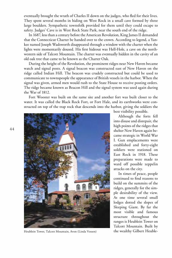
44
eventually brought the wrath of Charles II down on the judges, who fled for their lives. They spent several months in hiding on West Rock in a small cave formed by three large boulders. Sympathetic townsfolk provided for them until they could escape to safety. Judges’ Cave is in West Rock State Park, near the south end of the ridge.
In 1687, less than a century before the American Revolution, King James II demanded that the Connecticut Charter be handed over to the crown. According to legend, a Yan-kee named Joseph Wadsworth disappeared through a window with the charter when the lights were momentarily doused. His first hideout was Hell-Hole, a cave on the north-western side of Talcott Mountain. The charter was eventually hidden in the cavity of an old oak tree that came to be known as the Charter Oak.
During the height of the Revolution, the prominent ridges near New Haven became watch and signal posts. A signal beacon was constructed east of New Haven on the ridge called Indian Hill. The beacon was crudely constructed but could be used to communicate to townspeople the appearance of British vessels in the harbor. When the signal was given, armed men would rush to the State House to receive posting orders. The ridge became known as Beacon Hill and the signal system was used again during the War of 1812.
Fort Wooster was built on the same site and another fort was built closer to the water. It was called the Black Rock Fort, or Fort Hale, and its earthworks were con-structed on top of the trap rock that descends into the harbor, giving the soldiers the
best visibility possible.Although the forts fell
into disuse and disrepair, the high points of the ridges that shelter New Haven again be-came strategic in World War I. Gun emplacements were established and forty-eight soldiers were stationed on East Rock in 1918. These preparations were made to ward off possible zeppelin attacks on the city.
In times of peace, people continued to find reasons to build on the summits of the ridges, generally for the sim-ple desirability of the view. At one time several small lodges dotted the slopes of Sleeping Giant. By far the most visible and famous structure throughout the ranges is Heublein Tower on Talcott Mountain. Built by the wealthy Gilbert Heuble-Heublein Tower, Talcott Mountain, Avon (Linda Vossen)

45
in after the turn of the century as a residence, this sturdy stone house with its huge tower is an imposing and impressive man-sion. Now part of Talcott State Park, the tower is visited by many on a clear day for the wonderful view it offers.
Several other monuments have been placed on ridgetops to increase their visibility. The Sol-diers and Sailors Monument on East Rock has been a landmark since the late 1880s. It com-memorates those who died in several American wars. A castle tower on the ledges of East Peak in Meriden is an addition to the landscape in the romantic tra-dition. It was built by Walter Hubbard, who gave the entire property to the city of Meriden as a park. A trailside tower on the hip of Sleeping Giant was built in the 1930s as a Work Projects Administration (WPA) project. Another monolithic stone struc-ture stands on West Rock, but its purpose is strictly utilitarian: It is an air duct for the tunnel that passes through the ridge as part of the Merritt/Wilbur Cross Parkway.
The tower on Talcott Mountain is no longer alone because the length of the ridge is now picketed with radio transmission towers. As the highest points in central Connecti-cut, the ridges are desirable locations for telecommunication transmission. The towers transmit a variety of microwave signals for radio, television, telephone, and independent communication systems. For this reason the towers can be sited fairly close together with-out interfering with one another, and telecommunication companies, stations, and agen-cies speed words and images across the valley from one summit to another.
MANAGEMENT
As population has grown in the New England region, development of land for housing, industry, utilities, and roads has diminished and splintered our open space resource. This loss is felt profoundly by people seeking the out-of-doors for visual or spiritual refreshment and recreation. As the borders of one urbanized area blend into the next, it seems that “no matter where one goes, nature is somewhere else.” (Ehrenfeld, 1970). In
Castle Craig, East Peak, Meriden (DEEP)

46
a state as densely populated as Connecticut, it is clearly in the public interest to set aside and preserve natural lands for recreational purposes now and in the future.
Concern for the preservation of natural areas extends well beyond recreational con-siderations. Having witnessed local or global extinction of flora and fauna due to habi-tat destruction, people are increasingly aware of the importance of sustaining a variety of biotic communities and their physical habitats. Efforts to preserve biological diver-sity have evolved to encompass this approach. The preservation of natural diversity is now rooted in acquisition and preservation of a spectrum of land types that can support a wide variety of plants and animals.
Since the early 1970s, there has been a sustained effort in Connecticut to identify and inventory existing ecosystems and natural communities. Part of this process has been an attempt to record the presence of rare or endangered species and to assess the fragility of particular ecosystems in the face of development.
The trap rock ridge system in the Central Valley is important from both the perspec-tives of recreation and preservation. It represents the largest remaining open space in the region that has a natural character. Although not completely undisturbed or pristine, the native vegetation on most of the ridges has become reestablished, and most of these areas have retained or regained a natural quality. Since the ridges are set in the heart of the well-settled Central Valley, they are extremely important recreational areas because of their scenic qualities and their accessibility. In addition, the ridge system represents a habitat that supports remarkable natural diversity. For these reasons the system deserves preservation consideration. Of course, these two interests — recreation and preservation — can be conflicting. In order to manage the land for both, planners will depend on detailed knowledge of the ecosystem, ownership, and recreational use patterns.
On the basis of detailed studies by botanists and plant ecologists over many years, it is generally agreed that the rocky summits of the ridges are the most fragile part of the ridge ecosystem and are the areas most threatened. For a variety of reasons, it is here that many of the rare and unusual plants associated with the ridges are found. Recre-ational use can pose a threat to these plant communities simply because of the damage caused by the scuffle of human feet. Many of the plants found in the harsh environ-ment of the ledges are small and easily trampled. Once dislodged from the typically thin soils, they may fail to become reestablished. Another threat to the ridgetop plant community stems from recreational use of fire. Campfire rings casually constructed of basalt chunks are frequent testimony to the popularity of trailside fires. The dry and windy conditions that prevail on the summits allow fires to spread quickly and burn hot, devastating the sparse woodland community of the summit.
Control of the development and intensity of recreational use of the ridgetops has been determined in great part by their ownership. Many of the ridgetops of the Metacomet Ridge are within state-owned parks. Others, such as East Rock, are owned by munici-palities. Although this status has protected some of the rocky summits from commercial development, many of these areas receive heavy recreational use. This is particularly true of the park peaks on the outskirts of cities that are accessible by car. Other ridgetops within state ownership are accessible only by hiking trails and receive lighter use.
Much of the ridge system at the southern end of the range (including the northern half of West Rock, Totoket Mountain, Saltonstall Ridge, and others) is owned and managed by the South Central Connecticut Regional Water Authority as watershed

47
surrounding its reservoirs. For the most part there is limited public access to these properties. In addition, the water authority has policy goals that specify preservation and protection of the ridges for their scenic quality and as critical habitat. Due to these policies, the ridgetops that are owned by the water authority experience minimal disturbance. Portions of Talcott Mountain are similarly owned and managed by the Metropolitan District Commission of Hartford. These areas are open for recreation but are primarily managed as watershed protection areas.
Three areas in the state that have been set aside as refuges are on trap rock ridges. They are McLean Game Refuge, which encompasses the eastern Barndoor Hill, and two Nature Conservancy preserves, Higby Mountain and Onion Mountain. The public is welcome to hike in these preserves, but they are not managed primarily for recreation.
Thus, the patterns of utilization, development, and recreational use of the ridges span a spectrum from near zero to heavy use. In order to manage this remaining open space effectively for recreation and preservation, a variety of management strategies are needed. As more is learned about the exact location of particularly valuable ecological areas, this information can be “mapped” against current recreational demands. Using this kind of information to assess the ecosystem as a whole, it will be possible to plan to divert the distribution of recreational use away from ecologically sensitive areas, thus minimizing ecological impact on the system. Determining the desirability of areas for recreation and their ecological significance is an essential step toward an overall man-agement plan that will best preserve Connecticut’s natural heritage while providing its citizens with opportunities to enjoy and learn about the natural world.
East Rock Park, New Haven (Emily Lewis)

48
GLOSSARY
Algific: Causing cold or chilling.
Arkose: A feldspar-rich, typically coarse-grained sandstone.
Basalt: A general name for dark-colored, usu-ally fine-grained (magnesium and iron rich) igneous rocks that flowed onto the earth’s surface (extrusive) before solidifying. Can also be applied to the igneous rock that formed the dikes feeding the basalt flow. Commonly termed “trap rock” in Connecticut.
Columnar Jointing: Distinctive cracks re-sulting from contraction as basalt (and less commonly, other igneous rock) cools. These joints usually form prismatic columns that are polygonal in cross section.
Colluvium: Loose, incoherent mass of soil matter or rock fragments that collect at the base of hills.
Conglomerates: Coarse-grained sedimentary rocks made up of fragments of pre-existing rocks (usually larger than two millimeters in diameter) set in a finer matrix of cemented sand or silt.
Diabase: In common U.S. usage, an igne-ous rock that was intruded into existing rock (intrusive) rather than flowed onto the earth surface (as with extrusive basalt). Also called dolerite, diabase is generally fine-grained and contains labradorite and pyroxene. Com-monly termed “trap rock” in Connecticut.
Dikes: : Sheet-like igneous intrusions that cut discordantly across older sedimentary or metamorphic rock fabric, such as bedding or foliation.
Dip Slope: The gentle easterly slope of the land created by the tilted trap rock layers that form the asymmetric ridges of the Cen-tral Valley.
Dolerite: The British preferred term for diabase.
Edaphic: Referring to the characteristics of soil — physical, chemical, or biological — that influence living things, particularly plants.
Endangered Species: Any native species documented by biological research and inventory to be in danger of extirpation throughout all or a significant portion of its range within the state and to have no more than five occurrences in the state, and any species determined to be an “endangered species” pursuant to the federal Endangered Species Act.
Ericaceous: Describes members of the heath plant family, Ericaceae.
Escarpment: A long, steep, cliff-like ridge of land or rock.
Faulting: Fracturing of rock that results in relative movement (displacement) of once continuous rock components. Where no rela-tive movement exists across a rock parting, the term fracture is used (see also joints).
Feldspars: The most common group of rock-forming minerals.
Friable: A soil with a crumbly texture suit-able for good plant growth.
Glaciofluvial: Landforms or deposits pro-duced by streams formed by melting glaciers.
Glade: An open place in a forest.
Gneiss: A metamorphic rock that is commonly characterized by alternating bands or lenses (foliation) of granular and elongate or flat minerals. Commonly differentiated from schist (see below) by a lesser degree (less than 50 per-cent) of parallelism in mineral components.

49
Graben: An elongate trough, bordered on both sides by faults, and formed by down-dropped blocks of bedrock.
Igneous: One of the three rock types (the oth-ers are metamorphic and sedimentary). Igne-ous rocks solidified from molten rock (mag-ma). In Connecticut the predominant igneous rocks are basalt and diabase (see above).
Intrusion: In this usage, the process of the injection of molten rock (magma) into a pre-existing rock. Also the feature (e.g., dike) formed by the process of igneous intrusion.
Joints: Fractures or partings in rock that exhibit no relative movement (displacement) of the rock components.
Lava: The molten rock that issues from a volcano.
Massif: A very large topographic feature that is usually formed by rocks that are more du-rable than surrounding, lower-standing rocks.
Metamorphic: One of the three rock types (the others are igneous and sedimentary). Metamorphic rocks are rocks that have been changed to their present form from some pre-existing rock (usually by heat and below the earth surface).
Obligate Species: Occurs with estimated 99 percent probability within a particular habi-tat, such as wetlands.
pH: The symbol used to describe acidity or alkalinity on a scale of 1 (more acidic) to 14 (more alkaline).
Pyroxenes: A group of dark silicate miner-als that are common constituents of igneous rocks.
Ridge: A generic term usually applied to a long, narrow topographic high having a sharp crest and steep sides. The term is typically applied to features less than 8 km long.
Sandstone: A medium-grained clastic sedi-mentary rock composed mainly of rounded or angular, sand-sized mineral or rock fragments (clasts, thus the term clastic) that are set in a fine-grained matrix and bound together by a cementing material (often iron oxide, calcium carbonate, or silica). Deposited by water and/or wind, these rocks can contain fossils, and their color often indicates the conditions that prevailed during their deposition.
Schist: An obviously layered (foliated) meta-morphic rock that easily splits or flakes owing to a high degree (greater than 50 percent) of parallelism of its elongate and flat (e.g., mica) mineral components. Commonly occurs with gneiss (see above).
Sedimentary Rock: A rock formed by the deposition and consolidation of loose sedi-ment layers or by chemical precipitation. It can consist of cemented rock fragments (clas-tic, e.g., sandstone), cemented plant/animal remains (organic, e.g., certain limestones), and/ or minerals precipitated from solution (chemical, e.g., gypsum).
Serpentine: A group of common rock-form-ing minerals having the formula(Mg, Fe)
3Si
2O
5(OH)
4. The serpentine group
can exist in both igneous and metamorphic rocks.
Shales: Finely layered (laminated) sedimenta-ry rocks that typically contain at least 50 per-cent silt and 35 percent clay. These rocks gen-erally result from compaction of fine-grained sediments and usually split in thin slabs, paral-lel to the sedimentary layers (bedding).
Sills: Sheet-like igneous layers that intruded concordantly between older sedimentary beds or along foliation-related partings in metamorphic rocks.
Siltstones: Fine-grained sedimentary rocks that lack the thin layering (lamination) and flaking that typifies shale. Some definitions re-quire a higher silt content than that for shale.

50
Species of Special Concern: Any native plant species or any native non-harvested wildlife species documented by scientific research and inventory to have a naturally restricted range or habitat in the state, to be at a low popula-tion level, to be in such high demand by man that its unregulated taking would be detri-mental to the conservation of its population, or has been extirpated from the state.
Talus: The rock debris that accumulates against the base of cliffs and steep rocky slopes. In Connecticut, talus usually occurs as fairly coarse, angular accumulations of rock. The weathering characteristics of basalt are conducive to the formation of talus, but talus can form from a variety rock types.
Tectonic: The forces involved in regional fold-ing and faulting of the outer (solid/semi-solid) “skin” of the earth.
Texture: For soils, the physical nature of a soil according to the relative proportions of differ-ent size mineral particles categorized as sand, clay, and silt.
Threatened Species: Any native species doc-umented by biological research and inventory to be likely to become an endangered species within the foreseeable future throughout all or a significant portion of its range within the state and to have no more than nine occur-rences within the state, and any species deter-mined to be a “threatened species” pursuant to the federal Endangered Species Act, except for such species determined to be endangered by the commissioner in accordance with Section 4 of the Connecticut Endangered Species Act.
Till: Unsorted glacial sediments.
Vernal Pool: A contained basin depression, holding water for two or three months or more, which lacks breeding populations of fish and supports the breeding of specific animals including wood frogs or mole sala-manders or fairy shrimp.
Weathering: The action of natural forces such as wind or water on exposed rock.

51
REFERENCES
Bevier, L.R. (Editor). 1994. The Atlas of Breeding Birds of Connecticut. Bulletin113. Connecticut Departmental of Environmental Protection. Hartford, Connecticut.
DeGraaf, R.M. and D.D. Rudis. 1986. New England Wildlife: Habitat, Natural History and Distribution. General Technical Report NE-108. Northeastern Forest Experiment Station. USDA Forest Service. Broomhall, Pennsylvania.
Dowhan, J. J. and R. J. Craig. 1974. Rare and Endangered Species of Connecticut and Their Habitats. Report of Investigations No. 6.Connecticut Geological and Natural History Survey. The Natural Resources Center. Department of Environmental Protection. Hartford, Connecticut.
Ehrenfeld. D. W. 1970. Biological Conservation. Holt, Rhinehart and Winston, Inc., New York.
Haines, A. 2011. Flora Nova Angliae. A Manual for the Identification of Native and Naturalized Higher Vascular Plants of New England. The New England Wildflower Society and Yale Universtiy Press. New Haven,Connecticut.
Klemens, M.W. 1993. Amphibians and Reptiles of Connecticut and Adjacent Regions.Bulletin No. 112. Connecticut Department of Environmental Protection. Hartford,
Connecticut.
Klemens, M.W. 2000. Amphibians and Reptiles in Connecticut: A Checklist with Notes on Conservation Status, Identification and Distribution. Bulletin No. 32. Connecticut Department of Environmental Protection, Hartford, Connecticut.
Lee, C. 1985. West Rock to the Barndoor Hills: The Traprock Ridges of Connecticut. Vegetation of Connecticut Natural Areas No. 4. Connecticut Geological and Natural History Survey. Department of Environmental Protection. Hartford, Connecticut.
Metzler, K. J. and J. P. Barrett. The Vegetation of Connecticut, a Preliminary Classification. 2006. Report of Investigations No. 12. Connecticut Geological and Natural History Survey. Department of Environmental Protection, Hartford, Connecticut.
Proctor, N. S. 1978. 25 Birding Areas in Connecticut. The Pequot Press, Chester, Connecticut.
Rappole, J.H. and M. V. McDonald. 1994. Cause and Effect in Population Declines of Migratory Birds. Auk 111(3): 652-660.

52
Rodgers, J. 1985. Bedrock Geological Map of Connecticut. Connecticut Geological and Natural History Survey. Natural Resources Center. Department of Environmental Protection. Hartford, Connecticut.
Scott, J. A. 1975. Mate-locating Behavior in Western North American butterflies. The Journal of Research on the Lepidoptera 14:1-40.
USGS. 2012. 2008 Mineral Yearbook – Connecticut [Advanced Release]. U.S. Geological Survey. U.S. Department of the Interior. Washington, D.C.
Whyte, W.H. 1962 Connecticut’s Natural Resources: A Proposal for Action. Connecticut Department of Agriculture and Natural Resources. Hartford, Connecticut.
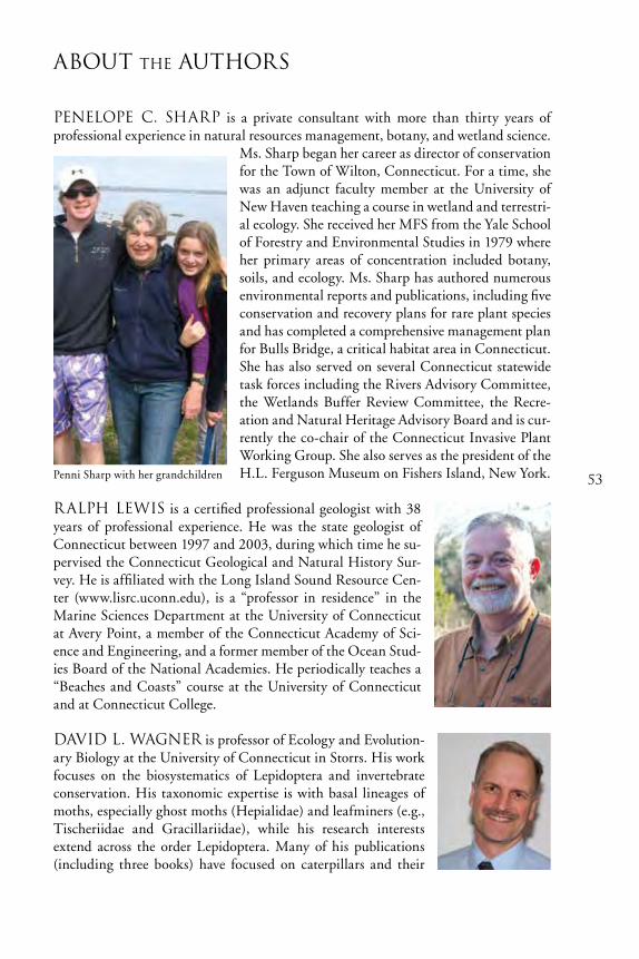
53
About the Authors
Penelope C. Sharp is a private consultant with more than thirty years of professional experience in natural resources management, botany, and wetland science.
Ms. Sharp began her career as director of conservation for the Town of Wilton, Connecticut. For a time, she was an adjunct faculty member at the University of New Haven teaching a course in wetland and terrestri-al ecology. She received her MFS from the Yale School of Forestry and Environmental Studies in 1979 where her primary areas of concentration included botany, soils, and ecology. Ms. Sharp has authored numerous environmental reports and publications, including five conservation and recovery plans for rare plant species and has completed a comprehensive management plan for Bulls Bridge, a critical habitat area in Connecticut. She has also served on several Connecticut statewide task forces including the Rivers Advisory Committee, the Wetlands Buffer Review Committee, the Recre-ation and Natural Heritage Advisory Board and is cur-rently the co-chair of the Connecticut Invasive Plant Working Group. She also serves as the president of the H.L. Ferguson Museum on Fishers Island, New York.
Ralph Lewis is a certified professional geologist with 38 years of professional experience. He was the state geologist of Connecticut between 1997 and 2003, during which time he su-pervised the Connecticut Geological and Natural History Sur-vey. He is affiliated with the Long Island Sound Resource Cen-ter (www.lisrc.uconn.edu), is a “professor in residence” in the Marine Sciences Department at the University of Connecticut at Avery Point, a member of the Connecticut Academy of Sci-ence and Engineering, and a former member of the Ocean Stud-ies Board of the National Academies. He periodically teaches a “Beaches and Coasts” course at the University of Connecticut and at Connecticut College.
David L. Wagner is professor of Ecology and Evolution-ary Biology at the University of Connecticut in Storrs. His work focuses on the biosystematics of Lepidoptera and invertebrate conservation. His taxonomic expertise is with basal lineages of moths, especially ghost moths (Hepialidae) and leafminers (e.g., Tischeriidae and Gracillariidae), while his research interests extend across the order Lepidoptera. Many of his publications (including three books) have focused on caterpillars and their
Penni Sharp with her grandchildren

54
natural history. Recent projects relating to invertebrate conservation have examined the importance of early successional habitats to invertebrates, pollinator decline, invasive species impacts, and climate-change threats.
Cara Lee has been The Nature Conservancy’s Shawangunk Ridge Program director since 2001. The Shawangunk Ridge is recognized as one of the most important landscapes for biodi-versity conservation in the northeastern United States. She is responsible for management of Sam’s Point Preserve, a 5,000-acre wildland preserve near Ellenville, New York. Ms. Lee is a graduate of Hamilton/Kirkland College and received her Master in Environmental Management from Yale University’s School of Forestry and Environmental Studies.

55
Index
Aadelgid, hemlock wooly 37 American Revolution 38, 43, 44Americans, Native 43amphibians vi, 19, 22, 28, 31animals iv, 1, 3, 5, 14, 22, 23, 28, 33, 35, 46, 50asphalt 40Authority, South Central Water 3, 46
BBarndoor Hills v, 7, 9, 51Basin, Hartford 5, 6, 7basin, rift 5Beacon Hill 44beacons, signal 44Berlin 2, 7, 8, 43Beseck Mountain 1Bethany, Lake 3birds 22, 31, 32, 34, 35Black Rock Fort 44Bluff Head 32butterflies v, 23, 26, 27, 52
CCastle Craig 45Cathole Mountain 2Cave, Judges’ 42, 44Central Valley 1, 3, 5, 6, 7, 8, 9, 10, 22, 29, 31, 38,
41, 43, 46, 48Charter Oak 44cliff face 14, 19climbing 21, 42, 43communities, plant vi, 1, 12-22, 46concrete 40Connecticut Charter 44Connecticut Forest and Park Association 42Connecticut Turnpike 40Connecticut Valley 1, 3, 11conservation 2, 50, 53, 54crushed rock 39, 40crushed stone 39, 40crusher, Eli Whitney Blake’s stone 39, 40
DDawson, Lake 3Dempsey, Gov. John 1Department of Transportation (CT) 40development 2, 4, 5, 8, 23, 27, 33, 42, 45, 46, 47dinosaurs 9
Eeastern slope 14, 15, 16, 17Eastern Uplands 1
East Rock 1, 7, 9, 32, 38, 44, 45, 46, 47ecology 12ecosystems, threats to 35Eli Whitney Blake’s stone crusher 39endangered species 19, 46, 48, 50exotic species 35
Fflora v, 14-21, 35, 46Fort Hale 44Fort Wooster 44fossils 9, 49frogs 14, 19, 28, 29
GGaillard, Lake 3, 33geologic provinces 5geology ii, iv, vi, 12, 38Giant, Sleeping 7, 9, 42, 43, 44, 45glade 26, 48glade, cedar 17, 18glade, fern 15Gloria, Hurricane 37Gov. John Dempsey 1gypsy moth 1, 35, 36, 37
HHale, Fort 44hang gliding 43Hanging Hills 1, 2, 8, 42Hartford II, 3, 5, 6, 7, 10, 11, 29, 31, 47, 51, 52Hartford Basin 5, 6, 7Hartford County 29hemlock wooly adelgid 37Heublein Tower 43, 44Higby Mountain 1, 23, 27, 31, 43, 47Higby Mountain Preserve 47hiking 41, 42, 46history iv, v, vi, 2, 5, 10, 54Holyoke Range 43Hubbard Park 3Hurricane Gloria 37
Iice in summer 21insects vi, 22, 26, 27, 34invasive species 35, 54
JJudges’ Cave 42, 44

56
KKing Philip (Metacomet) 42, 43
LLake Bethany 3Lake Dawson 3Lake Gaillard 3, 33Lake Watrous 3Lamentation Mountain 1, 2, 31, 42Lamentation Tri-town Project 2land preservation 2, 41, 46, 47legislation 2lizard 31Long Wharf 39
Mmammals 22, 34Manitook Mountain 43Mattabesett Trail 32, 42McLean Game Refuge 47Meriden 1, 2, 3, 4, 22, 42, 45Merimere Reservoir 3Metacomet (King Philip) 42, 43Metacomet Ridge 2, 43, 46Metacomet Ridge Conservation Compact 2Metacomet Trail 42microclimates v, 13, 20Middlefield 1, 23Middletown 2, 23migration 31, 32Mill River 38Monument, Soldiers and Sailors 45moths 26, 27, 35-37, 53Mountain, Higby 1, 23, 27, 31, 43, 47Mountain, Lamentation 1, 2, 31, 42Mountain, Manitook 43Mountain, Onion 7, 9, 47Mountain, Penwood 8Mountain, Ragged 43Mountain, Talcott 43-45, 47Mountain, Totoket v, 3, 32, 33, 42, 46Mountain, West Suffield 8Mount Higby 8
NNative Americans 43New Haven 1, 3, 7, 8, 9, 22, 23, 26, 31, 32, 36-44,
47, 51, 53New Haven Trap Rock Company 40North Branford 3, 40North Guilford 32
Oobligate species 19, 49Onion Mountain 7, 9, 47Onion Mountain Preserve 47
PPark, Hubbard 3Park, West Rock State 3, 44paving 39Penwood Mountain 8plant communities vi, 1, 12-22, 46plants iv, v, 1, 5, 12-22, 26, 35, 40, 41, 46, 48pools, vernal 14, 19, 31preservation, land 2, 41, 46, 47Preserve, Higby Mountain 47Preserve, Onion Mountain 47
Qquarries (quarry) 4, 38, 41Quinnipiac River 38Quinnipiac Trail 42Quinnipiac (tribe) 43
RRagged Mountain 43rare species v, 1, 2, 12, 14, 19, 22, 26-28, 31, 32,
35, 46recreation 32, 45, 46, 47Regicide’s Trail 42regulation, zoning 2, 41reptiles vi, 19, 22, 29, 31Reservoir, Merimere 3reservoirs 3, 47Ridge, Metacomet 2, 43, 46Ridge, Saltonstall 1, 8, 46rift basin 5River, Mill 38River, Quinnipiac 38rivers 3, 38rock climbing 43rock, crushed 39, 40
Ssalamanders 14, 22, 28, 29, 31, 50Saltonstall Ridge 1, 8, 46signal beacon 44signal posts 44Simsbury 43Sleeping Giant 7, 9, 42, 43, 44, 45snakes 27, 28, 29, 34, 43Soldiers and Sailors Monument 45Southbury 31South Central Water Authority 3, 46special concern species 26species, endangered 19, 46, 48, 50species, exotic 35species, invasive 35, 54species, obligate 19, 49species, rare v, 1, 2, 12, 14, 19, 22, 26-28, 31, 32,
35, 46

57
species, special concern 26species, threatened 18, 27, 31, 50stone, crushed 39, 40streams 3, 7, 8, 15, 28, 41, 48summit v, 14, 17, 18, 23, 27, 31, 32, 45, 46
TTalcott Mountain 43-45, 47talus 10, 11, 13, 14, 20-22, 27, 28, 31, 33, 34, 35,
37, 38, 50talus slope 14, 20, 22, 34, 37threatened species 18, 27, 31, 50threats to ecosystems 35, 46toad 18Totoket Mountain v, 3, 32, 33, 42, 46Tower, Heublein 43, 44Trail, Mattabesett 32, 42Trail, Metacomet 42Trail, Quinnipiac 42Trail, Regicide’s 42trees 15, 17, 18, 19, 21, 26, 29, 36, 37turtle 17-19
UUplands, Eastern 1Uplands, Western 1
Vvegetation 2, 9, 14, 35, 46vernal pools 14, 19, 31
WWar of 1812 44Watrous, Lake 3Western Uplands 1West Rock v, 3, 7, 9, 23, 26, 31, 36, 41, 42, 44,
45, 46, 51West Rock State Park 3, 44West Suffield Mountain 8wetlands 14, 19, 28, 29, 41Whyte, William H. 1wildflowers 14-21wildlife 22-35, 41, 50Woodbridge 3Woodbury 31World War I 44
XYZzoning regulation 2, 41

58
notes
ARBORETUM BULLETINS — PARTIAL LIST
No.28. The Connecticut Arboretum: Its First Fifty Years 1931-1981. 56 pp. 1982. Historical accounts of the formation and growth of the Arboretum. $2.50
No. 29. Mushrooms of New England. 49 pp. 1984. Descriptions of 89 species of fungi, 62 illustrated. $2.50
No. 30. Native Shrubs for Landscaping. 40 pp. 1987. Descriptions and lists of the best native shrubs for home, commercial and institutional landscaping. Color photographs. $5.00
No. 31. Birds of the Connecticut College Arboretum. 50 pp. 1990. An annotated list with seasonal records, and an account of the bird research program. Illustrated. $5.50
No. 32. The Connecticut College Arboretum--Its Sixth Decade and a Detailed History of the Land. 96 pp. 47photos. 1991. Historical accounts of the formation and growth of the Arboretum. Supplements Bulletin No. 28. $5.00
No. 33. Archaeology in the Connecticut College Arboretum. 56 pp. 1992. Detailed descriptions of prehistoric and historic archaeological sites in the Arboretum. Photographs and illustrations. $5.00
No. 34. Tidal Marshes of Long Island Sound:Ecology, History and Restoration. 72. pp. 1995. Describes the ecology and chronicles the history of Long Island Sound Tidal Marshes. Photographs and illustrations. $5.00
No. 35. Native Woody Plant Collection Checklist. 44 pp., 1 map. 1996. Listing in phylogenetic order of 288 taxa of trees, shrubs and woody vines cultivated in the Arboretum’s native plant collection. $2.00
No. 36. Amphibians and Reptiles of the Connecticut College Arboretum. 52 pp. 1998. Field Guide, checklist and summary of research on these animals in the Arboretum. Illustrated with line drawings, tables and graphs. $5.00
No. 37. Living Resources and Habitats of the Lower Connecticut River. 2001. 79 pp. Chapters on the geology, hydrology, human uses, ecology, bird, fisheries, trust species and management issues of the river from Cromwell to Long Island Sound. Photographs, illustrations, maps. $3.00
No. 38. The Hidden World of Plants: A Scanning Electron Microscope Survey of the Native Plant Collection, Connecticut College Arboretum. 40 pp. 2003. Brief description of scanning electron microscope and of the plant structures depicted in 50 stunningly detailed close-up photographs. $5.00
No. 39. Seaweeds of Long Island Sound. 104 pp. 2006. User-friendly guide to 80 species of algae found in Long Island sound, with a color photograph of each. Includes a simplified key to common species. $7.00
No.40. Saltmarsh Plants of Long Island Sound. 36 pp. 2009. Color illustrated guide to common tidal marsh plants in Connecticut and New York. $5.00
THE CONNECTICUT COLLEGE ARBORETUM ASSOCIATION
Membership is open to individuals and organizations interested in supporting the Arboretum and its programs. Members receive Arboretum publications, advance notice of programs and a discount on programs. For more information visit our website http://arboretum.conncoll.edu or call (860) 439-5020.

Connecticut Department of Energy & Environmental Protection