Embed Size (px)
Citation preview

Scientifi c Report from DCE – Danish Centre for Environment and Energy No. 27 2012
BRYOPHYTE DIVERSITY IN HIGH AND LOW ARCTIC GREENLANDEstablishment of permanent monitoring transects and bryophyte mapping in Zackenberg and Kobbefjord 2009-2010
AARHUS UNIVERSITYDCE – DANISH CENTRE FOR ENVIRONMENT AND ENERGY
AU

[Blank page]

Scientifi c Report from DCE – Danish Centre for Environment and Energy 2012
AARHUS UNIVERSITYDCE – DANISH CENTRE FOR ENVIRONMENT AND ENERGY
AU
BRYOPHYTE DIVERSITY IN HIGH AND LOW ARCTIC GREENLANDEstablishment of permanent monitoring transects and bryophyte mapping in Zackenberg and Kobbefjord 2009-2010
Kristian Hassel1
Tommy Prestø1
Niels M. Schmidt2
1 Norwegian University of Science and Technology, Museum of Natural History and Archaeology 2 Aarhus University, Department of Bioscience
No. 27

Data sheet
Series title and no.: Scientific Report from DCE – Danish Centre for Environment and Energy No. 27
Title: Bryophyte diversity in high and low arctic Greenland Subtitle: Establishment of permanent monitoring transects and bryophyte mapping in
Zackenberg and Kobbefjord 2009-2010
Authors: Kristian Hassel1, Tommy Prestø1, Niels M. Schmidt2
Institutions: 1Norwegian University of Science and Technology, Museum of Natural History and Archaeology, Trondheim, Norway 2Aarhus University, Department of Bioscience, Roskilde, Denmark
Publisher: Aarhus University, DCE – Danish Centre for Environment and Energy © URL: http://dce.au.dk/en
Year of publication: 2012 Editing completed: August 2012 Referee: David Boertmann, Department of Bioscience, Aarhus University
Financial support: The Danish Environmental Protection Agency
Please cite as: Hassel, K., Prestø, T. & Schmidt, N.M. 2012. Bryophyte diversity in high and low arctic Greenland. Establishment of permanent monitoring transects and bryophyte mapping in Zackenberg and Kobbefjord 2009-2010. Aarhus University, DCE – Danish Centre for Environment and Energy, 42 pp. Scientific Report from DCE – Danish Centre for Environment and Energy No. 27. http://www.dmu.dk/Pub/SR27.pdf
Reproduction permitted provided the source is explicitly acknowledged
Abstract: This report summarises the establishment of permanent bryophyte monitoring transects at high arctic Zackenberg and in low arctic Kobbefjord. Transects were established at Zackenberg in 2009 and in Kobbefjord in 2010. Along with the establishment of the permanent monitoring infrastructure, a detailed mapping of the bryophyte communities was conducted. At both sites, bryophytes were one of the main components both in terms of species diversity and frequency in the vegetation. At Zackenberg, species diversity was higher for bryophytes than vascular plants in all transects, except for transects located in snow beds or in the high altitudinal fen. In terms of frequency bryophytes were the dominating functional group in most transects. In Kobbefjord, bryophytes exhibited higher species diversity than vascular plants in most vegetation types, but they were never the dominating group in terms of frequency. The permanent monitoring infrastructure will allow for future reexaminations to assess the development in bryophyte species diversity in Greenland. All collected data are available through the database of Greenland Ecosystem Monitoring (www.g-e-m.dk).
Keywords: Arctic, biodiversity, bryophyte, climate change
Layout: Graphic Group, AU Silkeborg Front page photo: Kristian Hassel
ISBN: 978-87-92825-51-3 ISSN (electronic): 2245-0203
Number of pages: 42
Internet version: The report is available in electronic format (pdf) at http://www.dmu.dk/Pub/SR27.pdf
Contents
Preface 5
Summary 6
Sammendrag 7
1 Introduction 8
2 Methods 10
3 Results 12 3.1 Zackenberg 12 3.2 Kobbefjord 19
4 Concluding remarks 26
5 References 28
Appendix 1 Photos of the analysed transects and plots at Zackenberg 30
Appendix 2 Photos of the analysed transects and plots at Kobbefjord 37

[Blank page]

5
Preface
While the biodiversity of vascular plants is relatively well-known for the two monitoring sites within the Greenland Ecosystem Monitoring (Zacken-berg and Kobbefjord), only little information is available on the diversity of the bryophytes there, and in Greenland in general. The aim of the present study was two-fold. Firstly, this study was initiated in order to provide a contemporary inventory of the bryophyte diversity at the two sites. Second-ly, at both sites this study established a number of permanent transects for monitoring the changes in bryophyte diversity over the years. The present report thus both provides a status of the current bryophyte diversity at the two sites, but also provides a detailed description of the methodologies ap-plied as well as descriptions of the general characteristics of the individual monitoring plots along the transects.
The present project was financially supported by the Danish Environmental Protection Agency, and Norwegian University of Science and Technology, Museum of Natural History and Archaeology in Trondheim, Norway.
The authors thank Aarhus University and Greenland Institute of Natural Resources for providing access to Zackenberg and Kobbefjord, respectively.

6
Summary
This report summarises the establishment of permanent bryophyte monitor-ing transects at high arctic Zackenberg and in low arctic Kobbefjord. Tran-sects were established at Zackenberg in 2009 and in Kobbefjord in 2010. Along with the establishment of the permanent monitoring infrastructure, a detailed mapping of the bryophyte communities was conducted.
At both sites, bryophytes were one of the main components both in terms of species diversity and frequency in the vegetation. At Zackenberg, species diversity was higher for bryophytes than vascular plants in all transects, ex-cept for transects located in snow beds or in the high altitudinal fen. In terms of frequency bryophytes were the dominating functional group in most transects. In Kobbefjord, bryophytes exhibited higher species diversity than vascular plants in most vegetation types, but they were never the dominat-ing group in terms of frequency.
The permanent monitoring infrastructure will allow for future re-examinations to assess the development in bryophyte species diversity in Greenland. All collected data are available through the database of Green-land Ecosystem Monitoring (www.g-e-m.dk).

7
Sammendrag
Denne rapport opsummerer etableringen af permanente transekter til moni-tering af mosser ved henholdsvis Zackenberg (højarktis) og Kobbefjord (lavarktis). Transekterne ved Zackenberg og Kobbefjord blev etableret i hen-holdsvis 2009 og 2010. I forbindelse med etableringen af transekterne blev der gennemført en detaljeret kortlægning af mos-samfundene på de to loka-liteter.
På begge lokaliteter var mosser en af de vigtigste vegetationskomponenter, både hvad angår artsdiversitet og hyppighed. Ved Zackenberg var artsdi-versiteten af mosser højere end for karplanter i alle transekter, undtaget transekter i snelejer og højtliggende kær. I de fleste transekter var mosser desuden den dominerende gruppe mht. hyppighed. I Kobbefjord var artsdi-versiteten af mosser også større end karplanternes i de fleste transekter, men mosser var aldrig den dominerende gruppe mht. hyppighed.
De permanente moniteringstransekter muliggør ved fremtidige gen-analyser en detaljeret vurdering af ændringerne i diversiteten af mosser i Grønland. Alle de indsamlede data er tilgængelige via databasen for Greenland Eco-system Monitoring (www.g-e-m.dk).

8
1 Introduction
Bryophytes are an important plant group of arctic and tundra ecosystems both in relation to annual production of biomass and species diversity (Longton 1988). Based on data from different arctic communities in Alaska and Canada, annual net production of bryophytes is found to be highest in wet sedge moss meadow vegetation. Bryophytes also have a similar or high-er annual net production compared to vascular plants (above ground bio-mass) in most of the wet meadow, grass heath and dwarf shrub heath vege-tation studied (summarised by Longton 1988). The important role of bryo-phytes in relation to global carbon balance of peatlands and climatic warm-ing was early recognised (Gorham 1991), but the effect of the expected changes in vegetation are predicted to be even stronger in the bryophyte dominated tundra areas (Gornall et al. 2007, Walker et al. 2006). Both peat-land and tundra ecosystems are characterised by large areas of moist to wet soils with bryophytes as one of the dominating groups of plants. The poi-kilohydric nature of bryophytes makes them resistant to the repeated freez-ing and thawing in the Arctic. And a thick bryophyte layer ensures good in-sulation of the permafrost and also to some degree inhibits seed recruitment of vascular plants (Gornall et al. 2007, Soudzilovskaia et al. 2011). In bryo-phytes the lack of roots and conducting tissue for active uptake and transport of water and cuticles to hold water makes them dependent of a stable and humid microclimate for growth. Thus we find the most lush bry-ophyte vegetation in areas with stable water supply either by ground water, melting snow or by high frequency of precipitation. If the conditions become too dry for photosynthesis, the cells shut down the metabolism, and stay in-active until they are sufficiently moistened again.
There is a general trend that bryophyte diversity increases relative to vascu-lar plant diversity with increasing latitude. It is estimated that the total arctic bryophyte flora consist of 600-700 species, compared with about 900 vascu-lar plants (Longton 1988). For Svalbard 373 bryophytes and 173 vascular plants are known (Elvebakk and Prestrud 1996). In contrast the Scandinavi-an Peninsula has about twice as many vascular plant species as bryophyte species. The bryophyte flora of Greenland is relatively rich and consists of 613 species (Mogensen 1999). Norway which is of similar area as the ice free area of Greenland, but is mainly situated in the boreal zone, has 1071 bryo-phyte species (Hassel et al. 2010).
Most bryophytes found in the Arctic are also found in boreal and some even in temperate areas, but there are about 80 species that can be attributed to a circumpolar arctic element (Steere 1978). The lack of endemism among arctic bryophytes combined with a large number of circumpolar species, restricted to alpine areas if they occur outside the Arctic, may indicate that the arctic bryophytes in general have good capability of dispersal through production of spores, gemmae or gametophore fragments.
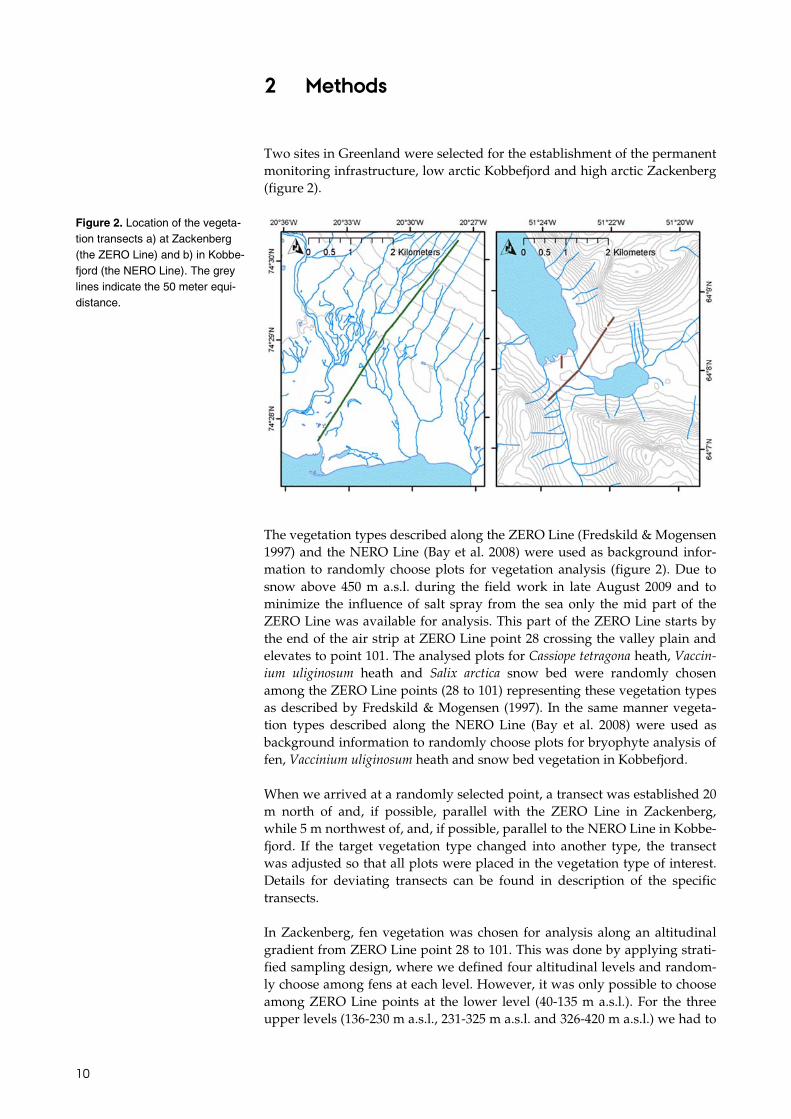
The vegetation in the Zackenberg valley in the high arctic zone (figure 1), is formerly mapped by Bay (1998) and the most important vegetation types for bryophytes by means of percentage cover are 1) grassland 98%, 2) fen 63 %, 3) Vaccinium uliginosum heath 31 %, 4) Salix arctica snow bed 14 % and 5) Cassiope tetragona heath 8%. A vegetation transect, “ZERO line”, was estab-lished by Fredskild and Mogensen (1997). It starts by the shore in Young Sund and ends at Aucellabjerg 1040 m above sea level (Figure 2). In total 11

9
different vegetation types are described along the ZERO Line and the vege-tation is described for 129 points along this transect. The vegetation in Kobbefjord, low arctic zone (figure 1), is not mapped in the whole valley, but is restricted to the “NERO line” transect (figure 2), established and described by Bay et al. (2008). The transect starts 166 m above sea level in a north-east facing slope, falls down to the valley bottom and rises to 400 m above sea level at a south-west facing slope. The NERO Line includes eight vegetation types, where the main vegetation types are 1) dwarf shrub heath with differ-ent subtypes according to the dominating shrub species, e.g. Empetrum her-maphroditum, Vaccinium uliginosum, 2) fen, 3) Salix herbacea snow bed, 4) Salix glauca copse and 5) herb slope. According to the Raunkjær analyses of the different vegetation types (Bay et al. 2008), bryophytes are very important in heath, snow bed and fen vegetation. The vegetation along the NERO Line is described in 91 points.
The main aim of the current study was to establish permanent transects and plots for long term monitoring of bryophytes within the frames of the Zackenberg and Nuuk Ecological Research Operations. The main vegetation types in each area are to be represented and for one of the dominating vege-tation types a transect covering an altitudinal gradient should be estab-lished.
Figure 1. The classification of the Arctic into the high, low and sub-arctic regions based on the Cir-cumpolar Arctic Vegetation Map (CAVM Team 2003). Also shown are the locations of Kobbefjord and Zackenberg.
10
2 Methods
Two sites in Greenland were selected for the establishment of the permanent monitoring infrastructure, low arctic Kobbefjord and high arctic Zackenberg (figure 2).
The vegetation types described along the ZERO Line (Fredskild & Mogensen 1997) and the NERO Line (Bay et al. 2008) were used as background infor-mation to randomly choose plots for vegetation analysis (figure 2). Due to snow above 450 m a.s.l. during the field work in late August 2009 and to minimize the influence of salt spray from the sea only the mid part of the ZERO Line was available for analysis. This part of the ZERO Line starts by the end of the air strip at ZERO Line point 28 crossing the valley plain and elevates to point 101. The analysed plots for Cassiope tetragona heath, Vaccin-ium uliginosum heath and Salix arctica snow bed were randomly chosen among the ZERO Line points (28 to 101) representing these vegetation types as described by Fredskild & Mogensen (1997). In the same manner vegeta-tion types described along the NERO Line (Bay et al. 2008) were used as background information to randomly choose plots for bryophyte analysis of fen, Vaccinium uliginosum heath and snow bed vegetation in Kobbefjord.
When we arrived at a randomly selected point, a transect was established 20 m north of and, if possible, parallel with the ZERO Line in Zackenberg, while 5 m northwest of, and, if possible, parallel to the NERO Line in Kobbe-fjord. If the target vegetation type changed into another type, the transect was adjusted so that all plots were placed in the vegetation type of interest. Details for deviating transects can be found in description of the specific transects.
In Zackenberg, fen vegetation was chosen for analysis along an altitudinal gradient from ZERO Line point 28 to 101. This was done by applying strati-fied sampling design, where we defined four altitudinal levels and random-ly choose among fens at each level. However, it was only possible to choose among ZERO Line points at the lower level (40-135 m a.s.l.). For the three upper levels (136-230 m a.s.l., 231-325 m a.s.l. and 326-420 m a.s.l.) we had to
Figure 2. Location of the vegeta-tion transects a) at Zackenberg (the ZERO Line) and b) in Kobbe-fjord (the NERO Line). The grey lines indicate the 50 meter equi-distance.

11
search for fens at each level and then choose randomly among them. We had at least three different fen localities to choose among at each level.
In Kobbefjord, Empetrum heath vegetation was analysed along an altitudinal gradient on the south-west facing slope of the valley. Also here this was done by stratified sampling, where we defined three altitudinal levels and randomly choose among Empetrum heaths at each level. However, at the mid level there was only one Empetrum dominated heath, and thus this was ana-lysed.
The vegetation analyses were carried out as described by Bay (1998). In each of the analysed vegetation types an analysis included five plots along a tran-sect with a distance of about 5 m. Each plot was analysed by “pinpoint” analysis using a frame of 0.7 m × 0.7 m with 100 pins. Pin number one was in the northwest corner. The method follows the International tundra experi-ment (ITEX) concept (Walker 1996). For each pin, plant species and height were identified and recorded. Bryophytes were recorded to species level; when the species identity was uncertain, material of the species were searched for outside the plot and collected for determination at the laborato-ry. Lichens were recorded mainly to genus level, vascular plant species were identified as far as possible and classified as graminoids, club mosses, herbs and woody plants. In addition open ground (debris/soil/bare ground) was recorded. A free search within plots were undertaken to record additional bryophyte species, as the pinpoint method tends to miss rare species.
The plots were permanently marked to allow for future revisits to the exact same spot. The marking consist of aluminium pipes in the corners, i.e. in the holes after the frame feet. However, in Zackenberg aluminium pipes were only used in the south-western (corner A) and north-eastern corner. The south-eastern and north-western corners were marked by nails in the feet holes. Thus it should be possible to relocate the plots by GPS-position to-gether with the use of a metal detector.
In Zackenberg the vegetation plots were analysed from August 19th to Au-gust 30th 2009 and in Kobbefjord from August 16th to August 24th 2010. At this time most vascular plants had finished flowering and started to set seeds/diaspores, and thus the plants started to get dead leaves. The fre-quency of vascular plants was therefore underestimated and we have prob-ably also missed species flowering early in the season. But this fact also means that it was easier to see and identify the bryophytes at ground level.
Nomenclature follows Hill et al. (2006) for mosses, Söderström et al. (2002) for liverworts, and Böcher et al. (1978) for vascular plants.

12
3 Results
3.1 Zackenberg The frequency of bryophytes in the studied vegetation types showed an in-crease from the dry Cassiope tetragona heath to the moist Vaccinium uligi-nosum heath to the wet Salix arctica snow bed and fen (figure 3). Along the same moisture gradient the relative importance of bryophytes increased compared with the other functional plant groups (figure 4).
Figure 3. The frequency (sum of hits in 5 replicates) of bryophytes is increasing from dry to more wet vegetation types. Fen 63 m a.s.l. is included among the fens as it is approximately at the same elevation as the other vegetation types included. The relative im-portance of bryophytes in the different vegetation types is max-imised in the snow bed vegeta-tion. The relative importance of bryophytes is calculated as bryo-phyte frequency/vascular plants frequency.
Figure 4. Frequency (sum of hits in 5 replicates) of species by functional groups in a) Cassiope tetragona heath, b) Vaccinium uliginosum heath, c) Salix arctica snow bed and d) fen 63 m a.s.l.
0
0,2
0,4
0,6
0,8
1
1,2
1,4
0
50
100
150
200
250
300
350
400
450
500
Cassiope tetragona heath
Vaccinium uliginosum heath
Salix arctica snow bed
Fen 63 m a.s.l.
Rel
ativ
e im
port
ance
Bry
ophy
te f
requ
ency
Bryophyte frequency
Relative importance of bryophytes
0
50
100
150
200
250
300
350
400
450
Woody Open ground Bryophytes Lichens Graminoids Herbs
Fre
quen
cyF
requ
ency
0
50
100
150
200
250
300
350
Woody Open ground Bryophytes Lichens Graminoids Herbs
0
50
100
150
200
250
300
350
Bryophytes Open ground Woody Herbs Graminoids Lichens
0
50
100
150
200
250
300
350
400
450
500
Bryophytes Graminoids Open ground Woody Herbs Lichens
A
B
C
D

13
Species diversity was dominated by bryophytes in Cassiope tetragona heath, Vaccinium uliginosum heath and fen (63 m a.s.l.) vegetation, while vascular plants were the most species-rich plant group in the Salix arctica snow bed (table 1). Bryophyte species diversity thus seemed to be negatively related to the moisture gradient, while the relative importance of bryophytes increased along the same gradient. A closer look at the species composition showed that long-lived perennials were dominating in the wet vegetation, while pi-oneer and colonist species were almost absent (table 2). In the Cassiope tetrag-ona heath and the Vaccinium uliginosum heath there were many pioneers and colonist species, and this may be explained by more open ground and possi-bly warmer microclimate compared to the wetter vegetation types.
3.1.1 Description of the analysed vegetation plots
The original data for the pin point analysis are stored in the GEM database (www.g-e-m.dk). Photo documentation of the transects and the individual plots are presented in appendix 1 and 2.
Cassiope tetragona heath, ZERO Line point 51. Due to large variation in the vegetation, we had to move plot 1, 5 m east of point 51 along the ZERO Line. Five plots were established 20 m north of this point parallel to the ZERO Line. The vegetation is a Cassiope dominated heath with Salix arctica (table 3).
Table 1. Plant diversity measured as number of species (cumulative over 5 replicates) in
the analysed vegetation types.
Vegetation type Bryophytes Vascular plants
Cassiope tetragona heath 22 6
Vaccinium uliginosum heath 27 14
Salix arctica snow bed 11 14
Fen 63 m a.s.l. 21 12
Table 2. The five most frequent bryophytes in the analysed vegetation types. Frequencies are sums of hits in 5 replicates.
Cassiope tetragona heath Vaccinium uliginosum heath Salix arctica snow bed Fen 63 m a.s.l.
Species Freq.Species Freq.Species Freq
.
Species Freq.
Dicranum laevidens 43 Dicranum sp. 89 Sanionia uncinata 55 Sanionia uncinata 89
Sanionia uncinata 36 Sanionia uncinata 62 Aulacomnium turgidum 28 Ptilidium ciliare 62
Gymnomitrion corallioides 20 Dicranum laevidens 59 Dicranum laevidens 24 Tomentypnum nitens 59
Gymnomitrion concinnatum 16 Racomitrium panschii 36 Polytrichum hyperboreum 24 Pseudocalliergon
brevifolium
36
Oncophorus wahlenbergii 13 Polytrichum hyperboreum 24 Schistidium sp. 19 Onchophorus virens 24

14
Vaccinium uliginosum heath, ZERO Line point 87. Fredskild & Mogensen (1997) described this point as “A mixed, mossy heath with Carex bigelowii, C. rupestris, Arctagrostis and Eriophorum triste”. In the upper part it gradually changed from a heath rich in Vaccinium to a Salix-Cassiope heath without Vaccinium.” The first vegetation plots were placed 40 m east of point 87 along the ZERO Line to get continuous Vaccinium heath vegetation 20 m north of the ZERO Line (Vaccinium heath plot 1). The Vac-cinium heath occurred as almost parallel stripes to the ZERO Line. The se-cond plot was 5 m north (Vaccinium heath plot 2), to follow the stripe of Vaccinium heath plot three had to be moved 5 m south (toward the ZERO Line; Vaccinium heath plot 3). Plot four and five (Vaccinium heath plot 4 and 5) were placed at 5 m intervals from plot three (table 4).
Tabel 3. Cassiope tetragona heath, plots established August 22nd 2009.
Variable Plot 1 Plot 2 Plot 3 Plot 4 Plot 5
GPS way point 293 294 295 296 297
Position (hddd mm
ss.s)
N74º28’48.3”
W20º31’52.9”
N74º28’48.4”
W20º31’52.6”
N74º28’48.6”
W20º31’52.2”
N74º28’48.7”W20º31
’51.9”
N74º28’48.8”
W20º31’51.7”
Altitude m a.s.l. 41 42 42 42 42
Inclination (estimat-
ed)
0 % 1 % 2 % 1 % 0 %
Soil moisture Moist Dry Dry Dry Dry
Ground texture Rough, incomplete
vegetation cover
Rather plain, small
part with bare soil,
some cracks > 5 cm
Crack 15 cm from
NE-SW corner
Many cracks in soil,
rough ground
Rising towards cor-
ners, some cracks
Additional bryophyte
species
None Conostomum
tetragonum, Poly-
trichum piliferum,
Polytrichastrum
alpinum, Aulacomni-
um turgidum
Pogonatum cf. den-
tatum, Racomitrium
canescens, Polytri-
chastrum alpinum,
liverwort - crust with
some possible add.
species
Polytrichastrum
alpinum
Polytrichastrum
alpinum, Tritomaria
quinquedentata,
Lophozia sp., Anas-
trophyllum minutum
Tabel 4. Vaccinium uliginosum heath, plots established August 20th 2009.
Variable Plot 1 Plot 2 Plot 3 Plot 4 Plot 5
GPS way point 277 278 282 283 284
Position
(hddd mm ss.s)
N74º29’16.9”
W20º30’36.4”
N74º29’17.1”
W20º30’36.0”
N74º29’17.1”
W20º30’35.1”
N74º29’17.3”
W20º30’34.7”
N74º29’17.4”
W20º30’34.4”
Altitude m a.s.l. 104 104 104 105 105
Inclination
(estimated)
3 % 1-2 % 2-3 % 1 % 1 %
Soil moisture Dry, earlier in sea-
son moist
Dry, earlier in sea-
son moist
Dry Moist Moist, slightly
moister than plot 4
Ground texture Some bare soil, soil
with cracks up to 5
cm deep, but mostly
smooth
Rather flat, plain
surface, not many
crevices and few
depressions
Small depressions,
bare mineral soil in
small area
Plain surface with
some cracks, none
deep
Plain surface, very
few cracks in soil
Additional bryophyte
species
None Liverworts (sampled
outside plot)
Ptilidium ciliare,
Bartramia ithyphylla,
Schistidium gran-
direte, Encalypta cf.
alpina, Bryum sp.
Additional Conosto-
mum tetragonum
Additional Encalypta
rhaptocarpa, Bryum
sp, cf. Pseudocal-
liergon, Ptilidium
ciliare

15
Salix arctica snow bed, ZERO Line point 88. There was only a small strip with snow bed vegetation north of ZERO Line point 88. We therefore moved the transect to the south side of the ZERO Line. Plot 1 was established 20 m south of ZERO Line point 88 and the other four plots with 5 m interval eastwards parallel with the ZERO Line (table 5).
Fen altitudinal gradient with four transects 63 m a.s.l. to 420 m a.s.l. In the fen gradient the bryophytes constituted the major part of the vegeta-tion at all altitudes (figure 5), but the frequency decreased with altitude (fig-ure 6). Bryophytes were the more species rich group compared to vascular plants, except at the fen plots at highest altitude (table 6).
Table 5. Salix arctica snow bed, plots established August 24th 2009.
Variable Plot 1 Plot 2 Plot 3 Plot 4 Plot 5
GPS way point 324 325 326 327 328
Position
(hddd mm ss.s)
N74º29’17.2”
W20º30’29.5”
N74º29’17.4”
W20º30’29.1”
N74º29’17.5”
W20º30’28.7”
N74º29’17.6”
W20º30’28.3”
N74º29’17.8”
W20º30’27.8”
Altitude m a.s.l. 104 105 105 106 106
Inclination
(estimated)
1-2 % 2 % 1 % 2 % 3-4 %
Soil moisture Wet Wet Wet Moist, but a bit drier
than plot 1-3
Moist, as plot 4.
Ground texture Even, only small
unevenness in part
of plot
Small humps, but
rather even
Cracks, uneven 5-7
cm small depres-
sions
Some depressions,
6-8 cm deep
Some soil solifluction
along plot, small and
few cracks
Additional bryophyte
species
None Oncophorus wah-
lenbergii
Polytrichum piliferum Schistidium gran-
direte, Polytrichum
hyperboreum, Poly-
trichastrum alpinum
Tritomaria quin-
quedentata, Lopho-
zia sp.
Figure 5. Frequency (sum of hits in 5 replicates) of species by functional groups in fens along an altitudinal gradient from 63 to 420 m a.s.l.
Fre
quen
cyF
requ
ency
0
50
100
150
200
250
300
350
400
450
500
Bryophytes Graminoids Open ground Woody Herbs Lichens
Bryophytes Graminoids Open ground Woody Herbs Lichens
63 m a.s.l.
0
100
200
300
400
500
600
Bryophytes Graminoids Woody Herbs Open ground
168 ma.s.l.
0
50
100
150
200
250
300
350
400
284 m a.s.l.
0
50
100
150
200
250
300
350
Open ground Bryophytes Graminoids Woody Herbs Lichens
419 ma.s.l.

16
In terms of life history strategies we saw a dominance of long lived perenni-al species at the three lower fen transects. These species are characterised by investing most of their resources in vegetative growth and rarely reproduce sexually. The 419 m a.s.l. fen transect deviated from this picture by being dominated by colonist mosses, characterised by medium long life span and relatively high investments in reproduction (table 7).
3.1.2 Description of the analysed vegetation plots in the fen altitudinal gradient
Fen transect 1, ZERO Line 67 (63 m a.s.l.) The fen vegetation by ZERO Line point 67 was in a restricted area. To place the transect at some distance away from the ZERO Line we had to move 30 m eastwards along the ZERO Line, then we were able to establish a transect with five plots at a distance of 10 m north of the ZERO Line (table 8).
Figure 6. The bars show the frequency (sum of hits in 5 repli-cates) of bryophytes in fen vege-tation with increasing altitude, while the line shows the relative importance of bryophytes at the different altitudes. The relative importance of bryophytes is cal-culated as bryophyte frequen-cy/vascular plants frequency.
Table 6. Plant diversity measured as number of species (cumulative over 5 replicates)
along the altitudinal fen gradient.
Fen altitude m a.s.l. Bryophytes Vascular plants
419 16 19
284 24 13
168 18 13
63 21 12
Table 7. The five most frequent bryophytes in the analysed fen gradient. Frequencies are sums of hits in 5 replicates.
Fen 63 m a.s.l. Fen 168 m a.s.l. Fen 284 m a.s.l. Fen 419 m a.s.l.
Species Freq. Species Freq. Species Freq. Species Freq.
Sanionia uncinata 116 Sanionia uncinata 106 Campylium sp. 84 Bryum sp. 23
Ptilidium ciliare 75 Ptilidium ciliare 75 Tomentypnum nitens 74 Ditrichum flexicaule 23
Tomentypnum nitens 34 Campylium stellatum 74 Philonotis sp. 56 Sanionia uncinata 23
Pseudocalliergon
brevifolium
28 Aulacomnium turgidum 67 Ditrichum flexicaule 33 Oncophorus
wahlenbergii
13
Onchophorus virens 27 Polytrichum strictum 48 Sanionia uncinata 32 Scorpidium
scorpioides
8
Rel
ativ
e im
port
ance
Bry
ophy
te f
requ
ency
Bryophyte frequency
Relative importance of bryophytes
0
0,5
1
1,5
2
2,5
0
100
200
300
400
500
600
63 168 284 419m a.s.l.

17
Fen transect 2, 168 m a.s.l. Four fens were located at mid altitudinal level north of the ZERO Line and north of the closest river valley. One fen was randomly selected and a tran-sect with five plots were established. The direction from plot 1 towards plot 5 was 69° (0-400° scale). The medium rich sloping fen with Eriophorum triste, E. scheuchzeri, Poa arctica, Salix arctica, Carex bigelowii, Potentilla hyparctica, Carex capillaris, Juncus triglumis, Arctagrostis latifolia and Alopecurus alpinus (Juncus castaneus was not observed) . A rock with another rock on top of it is situated 5 m southeast of plot 1 (table 9).
Table 8. Fen transect 1, plots established August 27th 2009.
Variable Plot 1 Plot 2 Plot 3 Plot 4 Plot 5
GPS way point 377 373 374 375 376
Position (hddd mm
ss.s)
N74º29’06.5”
W20º31’07.8”
N74º29’06.7”
W20º31’07.5”
N74º29’06.8”
W20º31’07.0”
N74º29’06.9”
W20º31’06.6”
N74º29’07.0”
W20º31’06.1”
Altitude m a.s.l. 63 63 64 64 64
Inclination (estimat-
ed)
2 % 0-2 % 0-2 %, 1% average 0-5, 2% average 2 %
Soil moisture Moist Moist – wet Wet Wet, moist to stand-
ing water
Standing water –
moist
Ground texture Few small cracks,
few cushions and
depressions, other-
wise even
One rock in plot, a
larger depression,
two levels in plot,
otherwise even, no
soil cracks
Open water in 40%,
small hummocks and
depressions, no
cracks in soil, no
stones
15 cm from top to
bottom, large cush-
ions and deep de-
pressions, one big-
ger than the others,
standing water
Some hummocks,
smaller than previ-
ous plot, some open
depressions
Additional bryophyte
species
Polytrichastrum
alpinum
Aulacomnium tur-
gidum, Dicranum
sp., Bryum sp.
Bryum sp. None Oncophorus wah-
lenbergii, Oncopho-
rus virens, Au-
lacomnium turgidum
Tabel 9. Fen 2, plots established August 29th 2009.
Variable Plot 1 Plot 2 Plot 3 Plot 4 Plot 5
GPS way point 391 387 388 389 390
Position
(hddd mm ss.s)
N74º29’39.2”
W20º30’12.6”
N74º29’39.4”
W20º30’12.4”
N74º29’39.5”
W20º30’12.0”
N74º29’39.6”
W20º30’11.6”
N74º29’39.7”
W20º30’11.2”
Altitude m a.s.l. 168 168 168 169 169
Inclination
(estimated)
3 % 3 % 2 % 2 % 3 %
Soil moisture Moist Moist Moist Moist Moist
Ground texture Even, but with one
depression in upper
part, no stones or
soil cracks
Some depressions
and a musk ox foot-
print, A ridge on one
diagonal, otherwise
even. No stones or
cracks.
Very even, gently
sloping
Even, plain, no
hummocks or de-
pressions or soil
cracks
Two significant
hummocks with
minor depressions.
Otherwise quite
even.
Additional bryophyte
species
Scorpidium re-
volvens, Bryum
pseudotriquetrum,
Polytrichastrum
alpinum, Ditrichum
flexicaule
Ditrichum flexicaule Tritomaria quinque-
dentata, Bryum
pseudotriquetrum,
Oncophorus wah-
lenbergii
Tritomaria quinque-
dentata, Scorpidium
revolvens, Ptilidium
ciliare
Tritomaria quinque-
dentata, Warnstorfia
sarmentosa, Oncop-
horus wahlenbergii,
Ditrichum flexicaule

18
Fen transect 3, 284 m a.s.l. Three fens were located at the upper altitudinal level north of the ZERO Line and north of the closest river valley. A fen was randomly selected and a transect with five plots were established. The direction from plot one to-wards plot five is 49° (0-400° scale). Rich sloping fen with Juncus castaneus as a character species, other vascular plants were Pedicularis flammea, Saxifraga hirculus, Eriophorum triste, E. scheuchzeri, Salix arctica and Carex capillaris. Rock with a white rock on top is located 4 m northwest of plot 1. Rock with grey rock on top of it 6 m east of plot 1 (table 10).
Fen transect 4, ZERO Line 101 (419 m a.s.l.) The vegetation starts to break up at this altitude and it is difficult to find ar-eas with homogenous vegetation due to frost and unstable soils (solifluc-tion). Fredskild and Mogensen (1997) describes the vegetation as species rich, varying from Dryas and Carex nardina at dry soil to Deschampsia brevifo-lia-Alopecurus-Juncus biglumis on wet soils. The transect was placed 20 m north and 20 m east of the ZERO Line point 101, in wet fen with some seep-ing water. The transect consists of five plots with 5 m interval parallel to the ZERO Line (table 11).
Table 10. Fen 3, plots established August 28th 2009.
Variable Plot 1 Plot 2 Plot 3 Plot 4 Plot 5
GPS way point 380 381 382 383 384
Position
(hddd mm ss.s)
N74º29’56.2”
W20º29’00.8”
N74º29’56.4”
W20º29’00.6”
N74º29’56.6”
W20º29’00.3”
N74º29’56.7”
W20º29’00.1”
N74º29’56.9”
W20º28’59.8”
Altitude m a.s.l. 284 285 285 285 286
Inclination
(estimated)
3 % 3 % 2-3 % 3 % 3 %
Soil moisture Moist Moist Moist Moist Moist
Ground texture Even, no stones, no
hummocks, no large
cracks or depres-
sions
Even surface, no
stones, no bare soil
or cracks, no hum-
mocks
Even structure, no
stones, hummocks
or soil cracks
Some plots of bare
soil, some small soil
cracks, no stones,
hummocks
Varied topography,
small hummocks,
some bare soil
(20%), no stones or
larger soil cracks
Additional bryophyte
species
Distichium inclina-
tum, Oncophorus
wahlenbergii
Distichium capil-
laceum
Distichium inclina-
tum, Oncophorus
wahlenbergii, Dicho-
dontium pellucidum,
Bryum sp.
cf. Tortula Aulacomnium tur-
gidum, Encalypta cf.
procera, Scorpidium
revolvens, Distichi-
um capillaceum

19
3.2 Kobbefjord The bryophytes show an expected increase in frequency from the very dense Vaccinium uliginosum heath dominated by woody plants and graminoids to the more open and moist Salix herbacea snow bed and poor fen vegetation. Surprisingly, we find the highest frequency of bryophytes in the moist Em-petrum heath at 26 m a.s.l. (figure 7). The relative importance of bryophytes to vascular plants decrease from snow bed and poor fen vegetation to the Vaccinium uliginosum heath (table 12, figure 8).
Table 11. Fen 4, plots established August 25th 2009.
Variable Plot 1 Plot 2 Plot 3 Plot 4 Plot 5
GPS way point 338 339 340 341 342
Position
(hddd mm ss.s)
N74º30’14.9”
W20º27’45.9”
N74º30’15.0”
W20º27’45.6”
N74º30’15.1”
W20º27’45.3”
N74º30’15.3”
W20º27’44.9”
N74º30’15.4”
W20º27’44.5”
Altitude m a.s.l. 419 420 421 421 422
Inclination
(estimated)
4% 3% 3% 2% 4-5%
Soil moisture Moist Moist-wet Moist-wet Moist-wet Wet
Ground texture One larger soil
crack. Some hum-
mocks in soil pat-
terning the plot.
One large stone, one
smaller, some bare
soil, even sloping
Even, only some
minor depressions
Some stones, mostly
small and one a bit
larger, bare soil,
musk ox footprint,
otherwise even
Two levels in plot,
75% wet and 25%
drier part, even soil
surface, no cracks,
very few stones
Additional bryophyte
species
Tortella fragilis,
Encalypta alpina,
Campylium stellatum
Warnstorfia sarmen-
tosa, Distichium cf.
inclinatum, Encalyp-
ta cf. rhaptocarpa,
Calliergon richard-
sonii
Tortella fragilis,
Cirriphyllum cir-
rosum, Philonotis cf.
fontana
Tortella fragilis,
Ditrichum flexicaule,
Syntrichia ruralis,
Polytrichum hyper-
boreum, Encalypta
alpina, Scorpidium
scorpioides
Tortella fragilis,
Polytrichum hyper-
boreum, Polytrichas-
trum alpinum, Cirri-
phyllum cirrosum
Figure 7. The frequency (sum of hits in 5 replicates) of bryophytes is increasing from dry to more wet vegetation types, while the rela-tive importance of bryophytes in the different vegetation types is at maximum in the snow bed vege-tation. The relative importance of bryophytes is calculated as bryo-phyte frequency/vascular plants frequency. Empetrum heath 26 m a.s.l. is included among the Em-petrum heaths as it is approxi-mately at the same elevation as the other vegetation types includ-ed.
Rel
ativ
e im
port
ance
Bry
ophy
te f
requ
ency
Bryophyte frequency
Relative importance of bryophytes
0
0,05
0,1
0,15
0,2
0,25
0,3
0,35
0,4
0
50
100
150
200
250
300
350
Vacciniumuliginosum heath
Salix herbaceasnow bed
Poor fen Empetrum heath 26 m a.s.l.

20
Plant species diversity in poor fen vegetation was dominated by bryophytes. In other vegetation types, the diversity of bryophytes was about the same as vascular plants (table 12). Bryophyte species diversity tends to increase with increased soil moisture, while the opposite is the case for vascular plants. If we take a closer look at the species list we see that long lived perennials (small spores) and long lived shuttle (large spores) are dominating all stud-ied vegetation types (table 13).
Table 12. Plant diversity measured as number of species (cumulative over 5 replicates) in
the analysed vegetation types.
Vegetation type Bryophytes Vascular plants
Empetrum heath 26 m a.s.l. 11 8
Poor fen 17 9
Salix herbacea snow bed 15 14
Vaccinium uliginosum heath 9 13
Figure 8. Frequency (sum of hits in 5 replicates) of species by functional groups in a) Empetrum heath 26 m a.s.l., b) Vaccinium uliginosum heath, c) Salix herbacea snow bed and d) poor fen.
Table 13. The five most frequent bryophytes in the analysed vegetation types. Frequencies are sums of hits in 5 replicates.
Poor fen Vaccinium uliginosum heath Salix herbacea snow bed
Species Freq. Species Freq. Species Freq.
Sphagnum lindbergii 106 Dicranum fuscescens 21 Polytrichastrum alpinum 62
Sphagnum compactum 34 Dicranum flexicaule 13 Brachythecium sp. 57
Loeskypnum badium 33 Sanionia uncinata 13 Barbilophozia hatchery 9
Gymnocolea inflata 24 Barbilophozia hatcheri 5 Dicranum cf. flexicaule 8
Warnstorfia fluitans 11 Polytrichastrum alpinum 4 Polytrichum juniperinum 7
A
B
C
D
0
100
200
300
400
500
600
700
800
900
Woody Bryophytes Detritus Graminoids Lichens Club mosses
0
100
200
300
400
500
600
700
800
Woody Detritus Graminoids Bryophytes Clubmosses
Herbs Lichen
0
50
100
150
200
250
300
350
400
Detritus Woody Bryophytes Graminoids Herbs Rocks Club mosses
Lichens
0
100
200
300
400
500
600
700
800
Graminoid Bryophyte Detritus Woody Open ground Lichen
Fre
quen
cyF
requ
ency

21
3.2.1 Description of the analysed vegetation plots
Poor fen vegetation, NERO Line point 50-51 Plot 1 was established 11 m north of the NERO Line point 50 and three m east of the NERO Line. The following plots were placed with five m inter-vals towards NERO Line point 51, parallel to the NERO Line (table 14).
Salix herbacea snow bed vegetation, NERO Line point 5-6 The transect was placed east of the NERO Line and starts five m east of NE-RO Line point five. The transect follows the snow bed and the distance to the NERO Line gradually increases. Plot 5 is 13 m east of the NERO Line point seven. Description of the plot is given in table 15.
Table 14. Poor fen vegetation, plots established August 23rd and 24th 2010.
Variable Plot 1 Plot 2 Plot 3 Plot 4 Plot 5
GPS way point 936 937 938 939 940
Position
(hddd mm ss.s)
N64º08’05.8”
W51º22’45.5”
N64º08’05.9”
W51º22’45.3”
N64º08’06.0”
W551º22’45.1”
N64º08’06.2”
W51º22’44.9”
N64º08’06.3”
W51º22’44.8”
Altitude m a.s.l. 22 22 22 21 21
Inclination
(estimated)
4º 12º 4º 0º 8º
Soil moisture Wet Wet Wet Wet Very wet, open water
in 25% of the plot
Ground texture Some bare peat
patches resulting
from erosion. No
rocks or big soil
cracks
Even plot with three
large cushions of
Scirpus caespitosus.
One rock is visible in
plot.
Even plot is one the
edge of a small
brook/seepage. No
visible rocks or soil
cracks.
Even plot. No visible
rocks or soil cracks.
Even plot. No visible
rocks or soil cracks.
Additional bryophyte
species
None Polytrichastrum
alpinum, Gymno-
colea inflata, On-
cophorus wahlen-
bergii
Pioneer bryophytes
in bottom layer were
hard to see due to
high water level this
day.
Sphagnum balticum None
Table 15. Salix herbacea snow bed, plots established August 17th 2010.
Variable Plot 1 Plot 2 Plot 3 Plot 4 Plot 5
GPS way point 867 868 869 870 871
Position
(hddd mm ss.s)
N64º07’39.2”
W51º23’41.8”
N64º07’39.3”
W51º23’41.5”
N64º07’39.2”
W51º23’41.1”
N64º07’39.2”
W51º23’40.7”
N64º07’39.3”
W51º23’40.5”
Altitude m a.s.l. 135 133 131 130 128
Inclination
(estimated)
16º 27º 15º 16º 20º
Soil moisture Moist Moist Moist Moist Moist
Ground texture Big rock in lower part
of plot, mostly out-
side plot. No soil
cracks.
Ca. 10 % of plot is
made up by one big
rock. Almost no bare
soil. No soil cracks.
Even texture
throughout plot.
Some small rocks,
dense vegetation.
Even texture
throughout plot.
Even texture. Few
rocks. Even and
dense vegetation.
Additional bryophyte
species
None Timmia austriaca Lophozia sp., Poly-
trichum juniperinum,
Polytrichum piliferum
Racomitrium elonga-
tum, Sanionia unci-
nata, Polytrichum
piliferum
Racomitrium elonga-
tum

22
Vaccinium uliginosum heath, NERO Line point 69-70 Originally, Vaccinium uliginosum heath is classified between the NERO Line points 70-71, but this was a too small area to place the plots. However, there was an area with well-developed Vaccinium heath below point 70, and we decided to use this. The transect was placed five m northwest of the NERO Line and parallel to this. Plot 1 is at the lowest altitude. There is a big rock just south east of plot 2. For description of the plots see table 16.
Empetrum heath altitudinal gradient with three transects from 26 m to 310 m a.s.l. Across the Empetrum heath altitudinal gradient, the bryophytes constituted about 0.3 (measured as bryophyte frequency/vascular plant frequency) of the vegetation at all altitudes, but the absolute frequency decreased with al-titude (figure 9), indicating that the vegetation became more open at higher altitudes. In terms of plant species diversity, bryophytes were the more spe-cies rich group at the lowest altitude, while vascular plants and bryophytes were similar at the two highest altitudes (table 17). Woody plants, mainly Empetrum, constituted the major part of the vegetation at all altitudes with bryophytes as the second most frequent functional group (figure 10).
Table 16. Vaccinium uliginosum heath, plots established August18th 2010.
Variable Plot 1 Plot 2 Plot 3 Plot 4 Plot 5
GPS way point 878 879 880 881 882
Position
(hddd mm ss.s)
N64º08’23.8”
W51º22’19.9”
N64º08’23.9”
W51º22’19.6”
N64º08’24.0”
W51º22’19.4”
N64º08’24.1”
W51º22’19.3”
N64º08’24.3”
W51º22’19.1”
Altitude m a.s.l. 91 92 93 95 96
Inclination
(estimated)
2º 16º 12º 4º 23º
Soil moisture Dry-moist Moist-dry Moist Moist Moist
Ground texture Flat plot with one
stone inside plot,
stone with vegetation
on top, 20 cm higher
than rest of the plot.
No soil cracks.
Even plot with small
depressions with
Sphagnum spp.
Dense vegetation in
even/flat plot. No
particular textures to
mention.
Uneven plot texture,
dense cover of vege-
tation, seepage
through plot.
Dense vegetation,
even plot without
hummocks or other
particular features.
Additional bryophyte
species
None Dicranum cf.
fuscescens
Barbilophozia hatch-
eri
Barbilophozia lyco-
podioides, Sanionia
uncinata, Brachythe-
cium sp. Polytri-
chastrum alpinum
Brachythecium cf.
reflexum
Table 17. Plant species diversity (cumulative over 5 replicates) along the altitudinal Em-
petrum heath gradient.
Empetrum heath transects (m a.s.l.) Bryophyte species Vascular plant species
310 6 6
120 6 6
26 11 8

23
In terms of life history strategies we saw a dominance of long lived perenni-al moss species at all altitudes. These species are characterised by investing most of their resources in vegetative growth and rarely reproduce sexually. t the highest altitude some colonist mosses characterised by medium long life span and relatively high investments in reproduction were also among the more frequent species (table 18).
Figure 9. The bars shows the frequency (sum of hits in 5 repli-cates) of bryophytes in Empetrum heath vegetation with increasing altitude, while the line show the relative importance of bryophytes at the different altitudes. The relative importance of bryophytes is calculated as bryophyte fre-quency/vascular plants frequen-cy.
Figure 10. Frequency (sum of hits in 5 replicates) of species by functional groups in Empetrum heath along an altitudinal gradi-ent from 26 to 310 m a.s.l.
Rel
ativ
e im
port
ance
Bry
ophy
te f
requ
ency
Bryophyte frequency
Relative importance of bryophytes
0
0,05
0,1
0,15
0,2
0,25
0,3
0,35
0
50
100
150
200
250
300
350
26 120 310
m a.s.l.
0
100
200
300
400
500
600
700
800
900
Woody Bryophytes Detritus Graminoids Lichens Club mosses
0
100
200
300
400
500
600
700
800
Woody Detritus Bryophytes Lichens Graminoids Club mosses
0
100
200
300
400
500
600
Woody Detritus Bryophytes Lichens Openground
Graminoids Rocks Herbs
26 m a.s.l. 120 ma.s.l.
310 m a.s.l.
Fre
quen
cyF
requ
ency

24
3.2.2 Description of the analysed vegetation plots in the Empetrum heath altitudinal gradient
Empetrum heath transect 1, NERO Line 52 (26 m a.s.l.) The transect starts 10 m north of the NERO Line point 52, and three m east of the NERO Line. The plots were placed at five m intervals parallel to the NERO Line, except for plot 5 which was only four m away from plot four due to upcoming fen vegetation (table 19).
Empetrum heath transect 2, NERO Line 74 (120 m a.s.l.). Empetrum heath occupies rather small areas by the NERO Line point 74. To get this altitudinal level represented (about 100 m a.s.l.), we chose to use the available areas of Empetrum heath. The consequence of this was that the transect had to be divided in two, with three plots southwest of the NERO Line point 74. This transect was only five m long so the plots were rather close to each other. The two other plots were placed northeast of the NERO Line point 73. Plot 4 is 11.5 m northeast of the NERO Line point 73 (table 20).
Table 18. The five most frequent bryophytes in the analysed Empetrum heath gradient. Frequencies are sums of hits in 5 repli-
cates.
26 m a.s.l. 120 m a.s.l. 310 m a.s.l.
Species Freq. Species Freq. Species Freq.
Pleurozium schreberi 128 Pleurozium schreberi 102 Ptilidium ciliare 77
Dicranum cf. flexicaule 76 Dicranum cf. flexicaule 72 Dicranum cf. flexicaule 63
Sphagnum russowii 62 Ptilidium ciliare 43 Cephaloziella sp. 8
Ptilidium ciliare 19 Hylocomium splendens 13 Pohlia nutans 1
Polytrichum strictum 14 Sanionia uncinata 3 Sphagnum compactum 1
Table 19. Empetrum heath transect 1, plots established August 22th 2010.
Variable Plot 1 Plot 2 Plot 3 Plot 4 Plot 5
GPS way point 918 919 920 921 922
Position
(hddd mm ss.s)
N64º08’07.7”
W51º22’42.6”
N64º08’07.8”
W51º22’42.4”
N64º08’08.0”
W51º22’42.2”
N64º08’08.1”
W51º22’42.0”
N64º08’08.2”
W51º22’41.8”
Altitude m a.s.l. 26 26 26 26 26
Inclination
(estimated)
4º 8º 8º 8º 4º
Soil moisture Moist Moist Moist Moist Moist
Ground texture No rocks, soil cracks
or no disturbance
patches.
Even plot in even
slope. No rocks, soil
cracks or no disturb-
ance patches.
Flat, even plot in
even slope. No
visible rocks, soil
cracks or disturb-
ance patches.
Even plot, mostly
flat. No visible rocks,
soil cracks or dis-
turbance patches.
Even plot. Almost no
depressions. No soil
cracks.
Additional bryophyte
species
None Barbilophozia lyco-
podioides, Ptilidium
ciliare
Lophozia ventricosa
s.l., Ptilidium ciliare
Lophozia ventricosa
s.l., Ptilidium ciliare,
Barbilophozia lyco-
podioides, Mylia
anomala, Calypogeia
sp.
Lophozia ventricosa
s.l., Dicranum flexi-
caule

25
Empetrum heath transect 3, NERO Line 76-77 (310 m a.s.l.) Due to high wind exposure and open soil by the NERO Line point 76, we started the transect by the NERO Line point 77. The first plot is placed 20 m south of and five m northwest of the NERO Line point 77. The transect has plots with five m interval and is parallel to the NERO Line (table 21).
Table 20. Empetrum heath 2, plots established August 21th 2009.
Variable Plot 1 Plot 2 Plot 3 Plot 4 Plot 5
GPS way point 912 913 914 915 916
Position
(hddd mm ss.s)
N64º08’26.1”
W51º22’17.0”
N64º08’26.2”
W51º22’16.9”
N64º08’26.2”
W51º22’16.8”
N64º08’25.7”
W51º22’16.0”
N64º08’25.6”
W51º22’15.9”
Altitude m a.s.l. 106 116 121 122 121
Inclination
(estimated)
20º 20º 16º 16º 12º
Soil moisture Dry Dry Dry Dry Dry
Ground texture Some soil cracks. No
bare soil or rocks.
Even slope in plot.
Even slope in plot.
No soil cracks or
rocks.
Even plot without soil
cracks or rocks.
Uneven plot. Dis-
turbed part in upper
slope. No rocks or
soil cracks.
Even, flat plot. No
rocks or bare soil.
No soil cracks or
disturbance patches.
Additional bryophyte
species
None None Pleurozium schreberiBarbilophozia lyco-
podioides, Ptilidium
ciliare
None
Table 21. Empetrum heath 3, plots established August 19th 2010.
Variable Plot 1 Plot 2 Plot 3 Plot 4 Plot 5
GPS way point 898 894 895 896 897
Position
(hddd mm ss.s)
N64º08’33.2”
W51º22’06.6”
N64º08’33.3”
W51º22’06.4”
N64º08’33.5”
W51º22’06.1”
N64º08’33.6”
W51º22’05.8”
N64º08’33.7”
W51º22’05.6”
Altitude m a.s.l. 308 309 311 314 313
Inclination
(estimated)
23º 16º 16º 16º 16º
Soil moisture Dry Dry Dry Dry Very dry
Ground texture Some small soil
cracks in plot. Some
small rocks and
some obvious frost
and wind disturb-
ance.
Even plot with some
few, small soil
cracks. No hum-
mocks.
Some rocks in lower
part of slope in plot
(SW corner). Some
bare soil in small
patches of plot.
Even and flat plot.
No rocks or soil
cracks. One small
depression in plot.
Bare soil in some
parts of plot. Some
small rocks.
Additional bryophyte
species
Ptilidium ciliare,
Bartramia ithyphylla,
Anastrophyllum
minutum
None None None None
26
4 Concluding remarks
In both the high arctic and the low arctic sites, the bryophytes were one of the main components both in terms of species diversity and frequency in the vegetation. In the high arctic Zackenberg area species diversity was higher for bryophytes than vascular plants in all the studied vegetation types ex-cept for the transects in snow bed and high altitudinal fen (419 m a.s.l.). In terms of frequency, bryophytes were the dominating functional group in all transects except the Cassiope and Vaccinium heath where woody plants not surprisingly were dominating. In the low arctic Kobbefjord area, the bryo-phytes have higher species diversity than vascular plants in most of the studied vegetation types, but they were never the dominating group in terms of frequency. In Kobbefjord woody plants were the functional group with highest frequency in all studied vegetation types, except poor fen vege-tation where graminoids were the dominating group. However, bryophytes were the second most frequent functional group in all vegetation types, ex-cept the Vaccinium heath where they were third (after woody plants and graminoids).
The altitudinal transect of fen vegetation in Zackenberg did not show the expected decline in species diversity with altitude, but we saw a shift in dominant species from competitive perennials at the three lower altitudes to opportunistic colonist species at the highest altitude. This may be due to a disturbance effect as the frequency of open ground was about three times higher at the highest altitude compared with the lower fens. The difference in disturbance also seemed to be the explanation for why we found the highest bryophyte frequency in the fen 168 m a.s.l. where the frequency of open ground was very low. The kind of disturbance seemed to be mainly trampling/grazing effect of the muskox at the three lowest altitudes while disturbance by frost and water movement were the important factors at the highest altitude.
In the Empetrum heath in Kobbefjord we found a weak, though expected de-cline in species diversity of bryophytes and vascular plants with altitude. But there was no obvious shift in species composition in relation to life his-tory strategies (as in Zackenberg). However, the frequency of bryophytes and vascular plants consistently decreased with altitude, resulting in a rela-tive constant component of bryophytes in the vegetation across altitudes. The main disturbance factor along this gradient seem to be a more rough and harsh (wind and temperature) environment with increasing altitude.
Vaccinium heath was studied in both areas. Clear differences were observed between low arctic Vaccinium heath dominated by woody plants and grami-noids as compared with the more bryophyte dominated high arctic Vaccini-um heath. This was probably the same effect as observed along the Empetrum heath altitudinal gradient with more dense vegetation at the lower altitudes. However the effect seemed to be much stronger from low arctic to the high arctic than along the c. 300 m long altitudinal gradient.
The other type of vegetation studied in both areas was the snow bed com-munity. Also here we saw as a general trend that woody plants were more dominating functional group at the low arctic site in Kobbefjord. Also saw that the frequency of bryophytes was much lower in Kobbefjord than in Zackenberg snow beds. Thus it seems that the low arctic snow beds were

27
more stabilised by vascular plants, which was also indicated by much lower frequency of open ground.
Expectations for future response of the bryophytes to climatic warming are that vascular plant vegetation will increase in height and be followed by in-creased shadowing and litter deposition, which will further decrease both bryophyte cover and species diversity. We expect to see the largest effects of warming in communities were the water stress will increase most, i.e. com-munities with stable moisture today that in the future may periodically dry with increased temperature and altered snow accumulation patterns. In-creased humidity by more frequent or higher precipitation could level out this effect, while a shift to more continental climate with less precipitation would strengthen the effect of increased temperature.
Interacting effects with herbivores like lemmings, disturbance from geese and trampling and grazing by muskoxen can change the dynamics of the bryophyte carpets.

28
5 References
Bay, C. 1998. Vegetation mapping of Zackenberg valley, Northeast Green-land. Danish Polar Center & Botanical Museum, University of Copenhagen, pp. 29.
Bay, C., Aastrup, P. & Nymand, J. 2008. The NERO line. A vegetain transect in Kobbefjord, West Greeenland. - National Environmental Research Insti-tute, Aarhus University, Denmark. NERI Technical Report 693, pp. 40.
Böcher, T. W., Fredskild, B., Holmen, K. & Jakobsen, K. 1978. Grønlands Flo-ra. - P.Hasse & søns forlag, pp. 307.
CAVM Team 2003. Circumpolar Arctic Vegetation Map. (1:7,500,000 scale), Conservation of Arctic Flora and Fauna (CAFF) Map No. 1. U.S. Fish and Wildlife Service, Anchorage, Alaska.
Elvebakk, A. & Prestrud, P. A 1996. Catalogue of Svalbard plants, fungi, al-gae and cyanobacteria. Norsk Polarinstitutt Skrifter 198: 1-395.
Fredskild, B. & Mogensen, G. S. 1997. ZERO Line, final report 1997. A de-scription of the plant communities along the ZERO line from Young Sund to the top of Aucellabjerg and the common plant communities in the Zacken-berg valley, Northeast Greenland. Danish Polar Center & Botanical Muse-um, University of Copenhagen, pp. 36.
Gorham, E. 1991. Northern Peatlands: Role in the Carbon Cycle and Proba-ble Responses to Climatic Warming. - Ecological Applications 1: 182-195.
Gornall, J. L., Jonsdottir, I. S., Woodin, S. J. & Van der Wal, R. 2007. Arctic mosses govern below-ground environment and ecosystem processes. - Oeco-logia 153: 931-941.
Hassel, K., Blom, H. H., Flatberg, K. I., Halvorsen, R. & Johnsen, J. I. 2010. Moser Anthocerophyta, Marchantiophyta, Bryophyta. - In: Norsk rødliste for arter 2010. The 2010 Norwegian Red List for Species. Artsdatabanken, Trondheim, pp. 139-153.
Hill, M. O., Bell, N., Bruggeman-Nannenga, M. A., Brugues, M., Cano, M. J., Enroth, J., Flatberg, K. I., Frahm, J. P., Gallego, M. T., Garilleti, R., Guerra, J., Hedenas, L., Holyoak, D. T., Hyvonen, J., Ignatov, M. S., Lara, F., Mazimpa-ka, V., Munoz, J. & Söderström, L. 2006. An annotated checklist of the moss-es of Europe and Macaronesia. - Journal of Bryology 28: 198-267.
Longton, R. E. 1988. The biology of polar bryophytes and lichens. - Cam-bridge University Press, Cambridge, pp. 391.
Mogensen, G. S. 1999. Moser. - In: Born, E. W. and Böcher, J. (eds.), Grøn-lands Økologi. Atuakkiorfik Undervisning, Nuuk, pp. 258-263.
Söderström, L., Urmi, E. & Vána, J. 2002. Distribution of Hepaticae and An-thocerotae in Europe and Macaronesia. - Lindbergia 27: 3-47.

29
Soudzilovskaia, N. A., Graae, B. J., Douma, J. C., Grau, O., Milbau, A., Shev-tsova, A., Wolters, L. & Cornelissen, J. H. C. 2011. How do bryophytes gov-ern generative recruitment of vascular plants? - New Phytologist 190: 1019-1031.
Steere, W. C. 1978. The mosses of Arctic Alaska. - J. Cramer, Vaduz.
Walker, M. 1996. Community baseline measurements for ITEX studies (eds). Danish Polar Centre, Denmark, -In: Molau, U. and Mølgaard, P. (eds.), ITEX Manual International Tundra Experiment. Danish Polar Centre, pp. 39–41.
Walker, M. D., Wahren, C. H., Hollister, R. D., Henry, G. H. R., Ahlquist, L. E., Alatalo, J. M., Bret-Harte, M. S., Calef, M. P., Callaghan, T. V., Carroll, A. B., Epstein, H. E., Jonsdottir, I. S., Klein, J. A., Magnusson, B., Molau, U., Oberbauer, S. F., Rewa, S. P., Robinson, C. H., Shaver, G. R., Suding, K. N., Thompson, C. C., Tolvanen, A., Totland, Ø., Turner, P. L., Tweedie, C. E., Webber, P. J. & Wookey, P. A. 2006. Plant community responses to experi-mental warming across the tundra biome. - Proceedings of the National Academy of Sciences of the United States of America 103: 1342-1346.

30
Appendix 1 Photos of the analysed transects and plots at Zackenberg
Cassiope tetragona heath

31
Vaccinium uliginosum heath

32
Salix arctica snow bed

33
Fen 63 m a.s.l.

34
Fen 168 m a.s.l.

35
Fen 284 m a.s.l.

36
Fen 419 m a.s.l.

37
Appendix 2 Photos of the analysed transects and plots at Kobbefjord
Vaccinium uliginosum heath

38
Salix herbacea snow bed

39
Poor fen

40
Empetrum heath 26 m a.s.l.

41
Empetrum heath 120 m a.s.l.
42
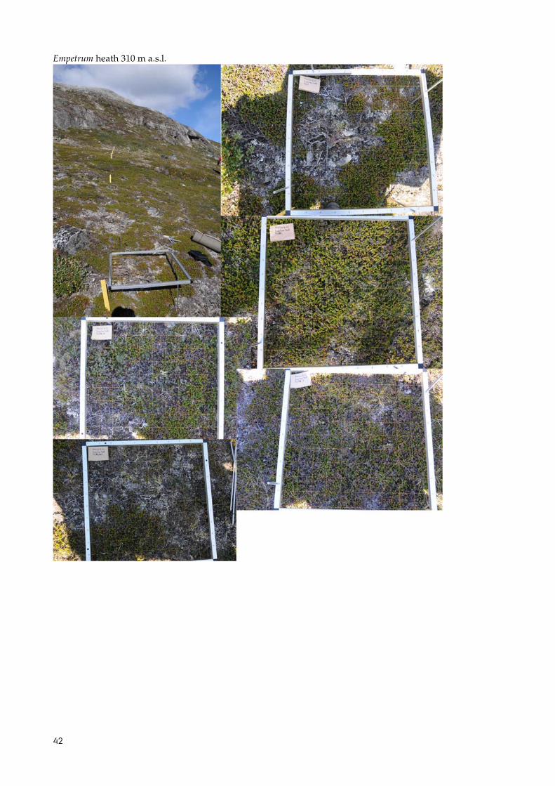
Empetrum heath 310 m a.s.l.

[Blank page]

BRYOPHYTE DIVERSITY IN HIGH AND LOW ARCTIC GREENLANDEstablishment of permanent monitoring transects and bryo-phyte mapping in Zackenberg and Kobbefjord 2009-2010
This report summarises the establishment of permanent bryophyte monitoring transects at high arctic Zackenberg and in low arctic Kobbefjord. Transects were established at Zackenberg in 2009 and in Kobbefjord in 2010. Along with the establishment of the permanent monitoring infrastruc-ture, a detailed mapping of the bryophyte communities was conducted.
At both sites, bryophytes were one of the main components both in terms of species diversity and frequency in the vegetation. At Zackenberg, species diversity was higher for bryophytes than vascular plants in all transects, except for transects located in snow beds or in the high altitudinal fen. In terms of frequency bryophytes were the dominating functional group in most transects. In Kobbefjord, bryophy-tes exhibited higher species diversity than vascular plants in most vegetation types, but they were never the dominating group in terms of frequency.
The permanent monitoring infrastructure will allow for future re-examinations to assess the development in bryo-phyte species diversity in Greenland. All collected data are available through the database of Greenland Ecosystem Monitoring (www.g-e-m.dk).
ISBN: 978-87-92825-51-3ISSN: 2245-0203