Embed Size (px)
Citation preview

BRR Leg 1 (4.0 miles, Easy)
Elevation (feet): Min 3881 Max 4948 Ascent +36 Descent -1027
Leg Legend: 0.0 Start (Grayson Highlands State Park Visitor Center) 4.0 Grayson Highlands State Park Office & Gate, on L
(EZ 1)
Leg Notes: Minimal traffic. Entire leg in Grayson Highlands State Park.
Leg Description: Steady, but controlled downhill. Great views of the Grayson Highlands’ balds and mountains. Watch for wild ponies.

BRR Leg 2 (7.5 miles, Hard)
Elevation (feet): Min 2756 Max 3881 Ascent +128 Descent -1276
Leg Legend: 0.0 S EZ 1 (Grayson Highlands State Park Office) 0.8 R Highlands Parkway #58 (Park Entrance) 0.9 L Spencer Branch Rd. #797 (gravel/dirt) 2.0 R Wolf Knob #746 (gravel/dirt) 2.9 RS Wallen’s Creek #1374 (paved) 0.5 L 194 N (paved) 0.4 Helton United Methodist Church, on L (EZ 2) Leg Notes: Stay alert for traffic on
Highlands Parkway (#58) and Hwy 194. These are more heavily traveled and have tight shoulders. Leg Description: Steady downhill, steep at
times. Narrow gravel/dirt roads at times.
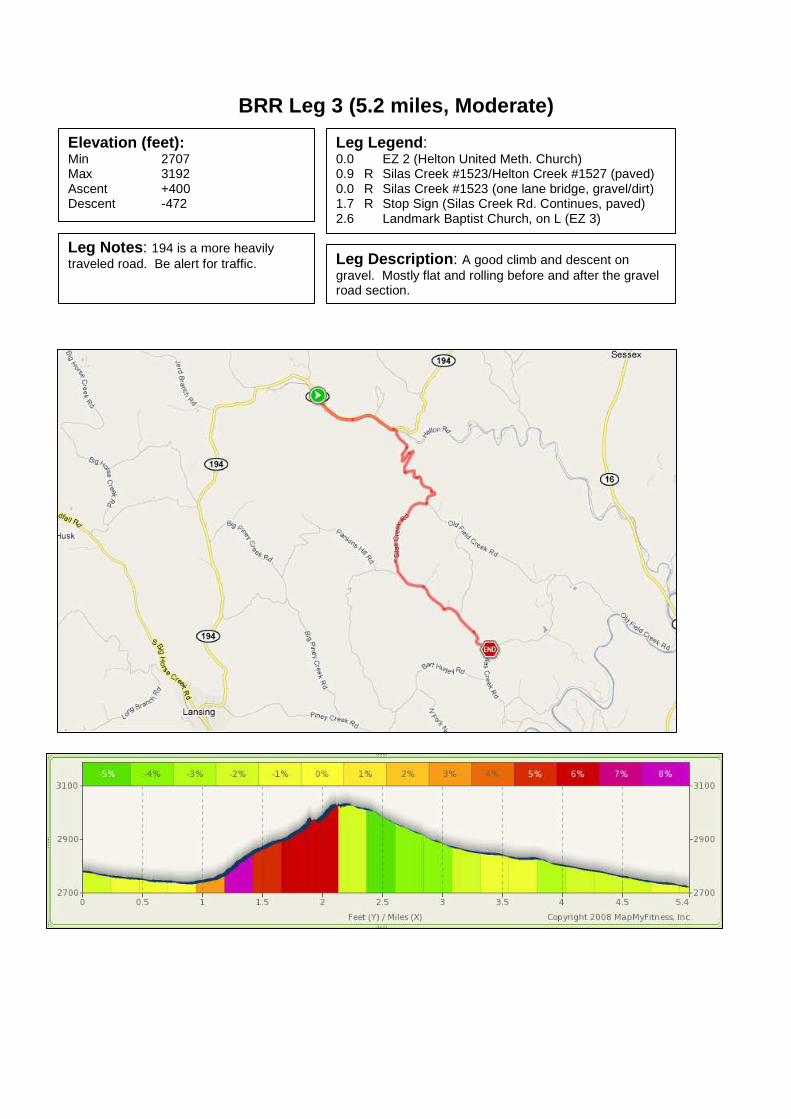
BRR Leg 3 (5.2 miles, Moderate)
Elevation (feet): Min 2707 Max 3192 Ascent +400 Descent -472
Leg Legend: 0.0 EZ 2 (Helton United Meth. Church) 0.9 R Silas Creek #1523/Helton Creek #1527 (paved) 0.0 R Silas Creek #1523 (one lane bridge, gravel/dirt) 1.7 R Stop Sign (Silas Creek Rd. Continues, paved) 2.6 Landmark Baptist Church, on L (EZ 3)
Leg Notes: 194 is a more heavily traveled road. Be alert for traffic. Leg Description: A good climb and descent on
gravel. Mostly flat and rolling before and after the gravel road section.

BRR Leg 4 (6.9 miles, Hard)
Elevation (feet): Min 2582 Max 3186 Ascent +643 Descent -285
Leg Legend: 0.0 EZ 3 (Landmark Baptist Church) 2.7 L North Fork New River Rd. #1513 (two lane bridge, paved) 0.6 R Old 16 South #1573 (paved) 2.9 R Ashe County Park Rd. #1511 (paved) 0.7 Ashe County Park, on L (EZ 4)
Leg Notes: Be very alert for traffic as you enter Old 16, which is a heavily traveled, winding road with narrow shoulders.
Leg Description: Great running along the New River. A good climb on Old 16. The distance and climb make this a Hard leg.

BRR Leg 5 (5.2 miles, Moderate)
Elevation (feet): Min 2907 Max 3199 Ascent +344 Descent -187
Leg Legend: 0.0 EZ 4 (Ashe County Park) 0.4 R Old 16 South 1573 (paved, run on right) 0.9 S Through traffic light, South Main St. (run on right) 1.8 L North 6th Ave. (Ashe County Ford Dealership on Right, Wilco Hess gas station on Left) 0.2 R East Main Street (Right at blinking red Traffic Light) 0.1 L South Third Ave. (1st Left, just before movie theatre) 0.1 R East Ashe St. (2 blocks, no choice but to turn Right) 0.1 S West Ashe St. (cross Jefferson Ave at Traffic Light) 0.1 L South Second Ave. (1st Left after Traffic Light) 0.1 R Long Street (1st Right) .05 L Graybeal Ave. (1st Left) 0.2 R Buck Mountain Rd. #1134 (at stop sign) 1.1 Friendly Grove Baptist Church, on R (EZ 5)
Leg Notes: Run on the right and use the shoulder and sidewalk, when available along Old 16 and South Main St. until you turn left on North 6th Ave. Be alert for traffic lights, stop signs, pedestrians, etc… Streets will be business as usual. Blind curve on Buck Mtn. Rd.
Leg Description: Mostly rolling, with one good climb on Buck Mountain Rd. Run through busy downtown West Jefferson.
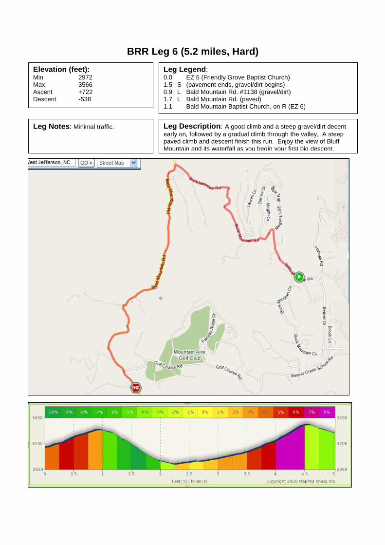
BRR Leg 6 (5.2 miles, Hard)
Elevation (feet): Min 2972 Max 3566 Ascent +722 Descent -538
Leg Legend: 0.0 EZ 5 (Friendly Grove Baptist Church) 1.5 S (pavement ends, gravel/dirt begins) 0.9 L Bald Mountain Rd. #1138 (gravel/dirt) 1.7 L Bald Mountain Rd. (paved) 1.1 Bald Mountain Baptist Church, on R (EZ 6)
Leg Notes: Minimal traffic. Leg Description: A good climb and a steep gravel/dirt decent early on, followed by a gradual climb through the valley, A steep paved climb and descent finish this run. Enjoy the view of Bluff Mountain and its waterfall as you begin your first big descent.

BRR Leg 7 (5.4 miles, Moderate)
Elevation (feet): Min 3051 Max 3419 Ascent +367 Descent -594
Leg Legend: 0.0 EZ 6 (Bald Mtn. Baptist Church) 1.3 R Baldwin Rd. #1248 0.8 R 194 South 0.8 L Grant Houck Rd. #1114 to East Mill Creek #1112 2.3 Zion Methodist Church, on L (EZ 7)
Leg Notes: 194 is a heavily traveled, winding road with tight shoulders. Be alert for traffic.
Leg Description: Mostly rolling and downhill. One monster climb about 1.0 mile before EZ 7.

BRR Leg 8 (4.6 miles, Easy)
Elevation (feet): Min 2890 Max 3146 Ascent +148 Descent -361
Leg Legend: 0.0 EZ 7 (Zion Methodist Church) 2.5 R Railroad Grade Rd. #1106 2.1 Riverside Restaurant, on L (EZ 8)
Leg Notes: Enjoy the views of the New River.
Leg Description: Mostly downhill and flat with one good climb and decent about the middle of the leg.

BRR Leg 9 (5.2 miles, Easy)
Elevation (feet): Min 2900 Max 3107 Ascent +226 Descent -85
Leg Legend: 0.0 Exchange #8 (Riverside Restaurant) 3.6 L Big Hill Rd. (Community of Todd) 1.6 Green Valley Community Park, on L (EZ 9)
Leg Notes: Great run along the New River.
Leg Description: Flat run with a bit of a climb on Big Hill Road (go figure).

BRR Leg 10 (8.2 miles, Very Hard)
Elevation (feet): Min 2963 Max 3425 Ascent +551 Descent -417
Leg Legend: 0.0 EZ 9 (Green Valley Community Park) 0.5 L River Rd. 2.0 L South Castleford Rd. 0.6 R Hardin Rd. (gravel/dirt) 2.1 S (gravel ends/paved begins) 2.4 S Brown’s Farm Rd. (Cross 421 4-lane highway) 0.6 Former Laurel Springs Baptist Church, on R (EZ 10)
Leg Notes: Enjoy the views of the New River while you can. All rural roads. Be alert for blind curves on Castleford. Be very alert as you cross Highway 421. Leg Description: The distance, along with a good climb on
Castleford and Hardin Rds. makes this a tough leg.

BRR Leg 11 (6.3 miles, Hard)
Elevation (feet): Min 2963 Max 3425 Ascent +518 Descent -407
Leg Legend: 0.0 EZ 10 (Former Laurel Springs Baptist Church) 0.05 R Old 421 0.5 L Blue Ridge Parkway Entrance 0.1 R Blue Ridge Parkway 4.6 R Exit Blue Ridge Parkway at Bamboo Gap (just over bridge) 0.1 L Little Laurel 0.1 R Bamboo 0.6 L Mount Vernon Baptist Church, on L (EZ 11)
Leg Notes: Support vehicles are not permitted on the Blue Ridge Parkway. Runners must wear a reflective vest while running on the Parkway. Bamboo is narrow with minimal shoulder. Leg Description: A very honest 10K+, but with awesome views
from the Blue Ridge Parkway.

BRR Leg 12 (7.9 miles, Very Hard)
Elevation (feet): Min 2963 Max 3425 Ascent +663 Descent -482
Leg Legend: 0.0 EZ 11 (Mt. Vernon Baptist Church) R Bamboo (turn right from church parking lot) 0.6 L Little Laurel 0.1 R Blue Ridge Parkway entrance 0.1 R Blue Ridge Parkway South 6.4 L Blue Ridge Parkway Exit (321/221 to Blowing Rock) 0.1 R 321/221 (run on the right on the shoulder) 0.6 R Tanger Outlet, on R (EZ 12)
Leg Notes: Support vehicles are not permitted on the Blue Ridge Parkway. Runners must wear a reflective vest while running on the Parkway. Run on the right on the shoulder on 321/221, grassy shoulder may be uneven.
Leg Description: Great running on the Blue Ridge Parkway, but tough leg because of the distance and long hill.

BRR Leg 13 (7.1 miles, Hard)
Elevation (feet): Min 3461 Max 3894 Ascent +486 Descent -423
Leg Legend: 0.0 EZ 12 (Tanger Outlet) R Business 321/221 (Blowing Rock, run on right) 0.8 R 221 South 6.3 Blue Moon Station, on L (EZ 13)
Leg Notes: Stay alert for traffic on 221. Tight shoulders. Caution Runner signs will posted frequently to warn on-coming traffic.
Leg Description: Rolling on 221 South. Stay alert for traffic.

BRR Leg 14 (10.0 miles, Very Hard)
Elevation (feet): Min 3556 Max 4373 Ascent +866 Descent -177
Leg Legend: 0.0 EZ 13 (Blue Moon Station) 221 South 10.0 Grandfather Mountain, on R (EZ 14)
Leg Notes: Some desolate stretches of road along the base of Grandfather Mountain. 221 is winding, stay alert.
Leg Description: Tough leg because of the distance and because most of it is a climb.

BRR Leg 15 (2.3 miles, Easy)
Elevation (feet): Min 3642 Max 4314 Ascent +10 Descent -669
Leg Legend: 0.0 EZ 14 (Grandfather Mountain) 2.2 S 221/181 (at Traffic Light) 0.2 Henson Building Supply, on L (EZ 15)
Leg Notes: 221 between Grandfather Mountain and the intersection with 105 is curvy with low, tight shoulders. Stop light at 221/105/181 intersection.
Leg Description: Downhill and short make this an easy one.
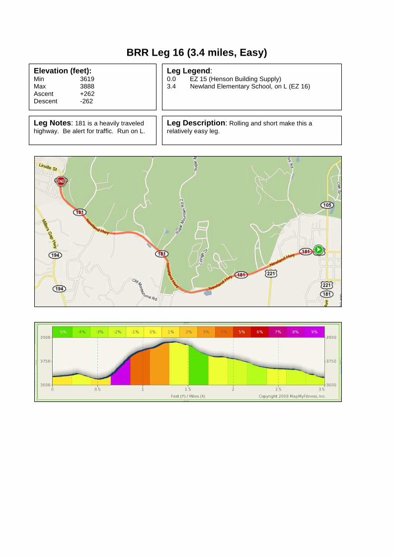
BRR Leg 16 (3.4 miles, Easy)
Elevation (feet): Min 3619 Max 3888 Ascent +262 Descent -262
Leg Legend: 0.0 EZ 15 (Henson Building Supply) 3.4 Newland Elementary School, on L (EZ 16)
Leg Notes: 181 is a heavily traveled highway. Be alert for traffic. Run on L.
Leg Description: Rolling and short make this a relatively easy leg.

BRR Leg 17 (4.9 miles, Moderate)
Elevation (feet): Min 3586 Max 4085 Ascent +502 Descent -259
Leg Legend: 0.0 EZ 16 (Newland Elementary School) 0.4 R 194 North (at Traffic Light) 0.2 L Old Toe River Rd. (at Traffic Light) 0.8 L Cow Camp 3.2 R Spanish Oak 0.3 Mt Pleasant Baptist Church/Gragg Nursery, on L (EZ 17)
Leg Notes: Running through downtown Newland, traffic lights, etc…, but quickly turns rural. Leg Description: Relatively short leg, but a good climb.

BRR Leg 18 (5.9 miles, Hard)
Elevation (feet): Min 2871 Max 3885 Ascent +249 Descent -1217
Leg Legend: 0.0 EZ 17 (Mt. Pleasant Baptist Church / Gragg Nursery) 3.3 L Lick Log 2.4 L 19E 0.2 Plumtree Presbyterian Church, on L (EZ 18)
Leg Notes: Rural route, but remain alert for traffic on narrow roads.
Leg Description: Big downhills and one good climb make this a tough leg. Spanish Oak turns into Squirrel Creek.

BRR Leg 19 (4.3 miles, Easy)
Elevation (feet): Min 2792 Max 2951 Ascent +69 Descent -138
Leg Legend: 0.0 EZ 8 (Plumtree Presbyterian Church) 4.3 Green Valley Fire Department, on R (EZ 19)
Leg Notes: 19E is a heavily traveled road. Be alert for traffic.
Leg Description: Flat and gentle downhill. Entire leg is on 19E. No turns.

BRR Leg 20 (7.5 miles, Very Hard)
Elevation (feet): Min 2746 Max 3340 Ascent +673 Descent -476
Leg Legend: 0.0 EZ 19 (Green Valley Fire Department) 0.8 R Hanging Rock Rd. 6.7 Mt. Carmel Baptist Church, on L (EZ 20)
Leg Notes: 19E is a heavily traveled road. Be alert for traffic.
Leg Description: Long leg with some tough climbs. One turn onto Hanging Rock Rd. Hanging Rock Rd. turns into Gouges Creek Rd. at the County Line, but is the same road.

BRR Leg 21 (2.4 miles, Easy)
Elevation (feet): Min 2523 Max 2881 Ascent +23 Descent -338
Leg Legend: 0.0 EZ 20 (Mount Carmel Baptist Church) 0.1 R 19E 0.8 R Spruce Pine 0.1 L Oak Avenue 1.1 L Highland Avenue 0.2 R Greenwood Road 0.1 Ingles Grocery Store, on L (EZ 21)
Leg Notes: Stay alert for traffic on 19E. Run on the Left.
Leg Description: Easy leg.

BRR Leg 22 (5.6 miles, Hard)
Elevation (feet): Min 2513 Max 2841 Ascent +535 Descent -282
Leg Legend: 0.0 EZ 21 (Ingles Grocery) 0.5 R 226/19 (at Stop Sign) 0.3 R 226 N (at Traffic Light) 2.9 L Penland Rd. 1.1 R Conley Ridge Rd. 0.8 Penland School Gallery, on R (EZ 22)
Leg Notes: Run on the right on 226/19. Run on the left on 226. Both roads are heavily traveled. Be alert to traffic.
Leg Description: Rolling with a good climb on Conley Ridge Road.

BRR Leg 23 (5.6 miles, Hard)
Elevation (feet): Min 2484 Max 2881 Ascent +463 Descent -423
Leg Legend: 0.0 EZ 22 (Penland School Gallery) 0.9 R Conley Ridge Rd. (gravel/dirt) 1.7 S (gravel ends, paved begins) 0.5 R Snow Creek Rd. 1.7 L Orchard Rd. 0.5 L 226N 0.3 Snow Creek Storage, on L (EZ 23)
Leg Notes: Mostly rural. Snow creek is narrow and winding. 226 is heavily traveled. Stay alert for traffic.
Leg Description: This leg starts easy, but the gravel downhill is followed by a good climb on Snow Creek.

BRR Leg 24 (3.2 miles, Easy)
Elevation (feet): Min 2441 Max 2963 Ascent +52 Descent -515
Leg Notes: 226 is heavily traveled. Remain alert for traffic.
Leg Legend: 0.0 EZ 23 (Snow Creek Storage)
Remain on 226 North 2.5 L South Mitchell Ave. 0.4 L Baker Lane (street sign on Left) 0.2 R Remain on Baker Lane at Friendship Baptist Ch. 0.1 Bakersville Fire Dept., on R (EZ 24)
Leg Description: Short and Sweet.

BRR Leg 25 (4.3 miles, Moderate)
Leg Description: elevation in feet Min 2238 Max 2523 Ascent +262 Descent -246
Leg Legend: 0.0 EZ 24 (Bakersville Fire Dept.) 4.3 Red Hill Baptist Church, on L (EZ 25)
Leg Notes: 226 is more heavily traveled, although the traffic will be lighter during night hours, stay alert for traffic.
Leg Notes: The distance, but mostly the rolling hills and big finishing hill make this moderate.

BRR Leg 26 (4.5 miles, Moderate)
Leg Description: elevation in feet Min 2208 Max 2579 Ascent +374 Descent -456
Leg Legend: 0.0 EZ 25 (Red Hill Baptist Church) 1.0 S Remain on 226 N, 197 N joins 0.1 L 197 North 2.0 L Remain on 197 N at Harrell Hill Rd. (after bridge) 1.4 Tipton Hill Elementary School, on R (EZ 26)
Leg Notes: 226 N often carries more traffic than 197 N. Both roads have many curves, stay alert for traffic. Leg Description: Some difficult hills, but the distance
makes this moderate.

BRR Leg 27 (9.0 miles, Hard)
Leg Description: elevation in feet Min 2073 Max 2546 Ascent +289 Descent -410
Leg Legend: 0.0 EZ 26 (Tipton Hill Elementary School) 2.0 L Whitson Branch Rd. / Green Mt. Rd. (turn left before going under the bridge) 0.3 R cross RR tracks (do NOT race the train) 0.1 L after bridge, Green Mountain Rd. 3.0 R Jacks Creek Rd. 3.6 Clearmont School Road, on L (EZ 27)
Leg Notes: The RR tracks are active, even at night. Stay alert for trains and do not attempt to race the train.
Leg Description: The distance makes this a hard leg.
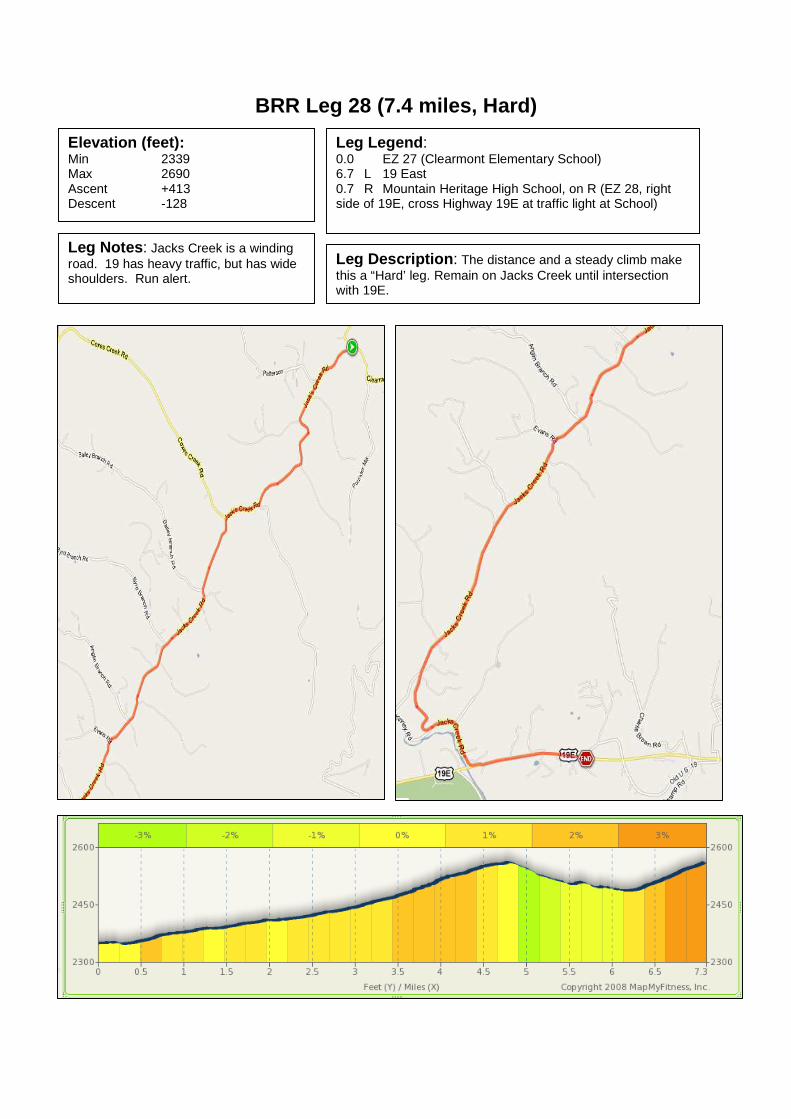
BRR Leg 28 (7.4 miles, Hard)
Elevation (feet): Min 2339 Max 2690 Ascent +413 Descent -128
Leg Legend: 0.0 EZ 27 (Clearmont Elementary School) 6.7 L 19 East 0.7 R Mountain Heritage High School, on R (EZ 28, right side of 19E, cross Highway 19E at traffic light at School)
Leg Notes: Jacks Creek is a winding road. 19 has heavy traffic, but has wide shoulders. Run alert.
Leg Description: The distance and a steady climb make this a “Hard’ leg. Remain on Jacks Creek until intersection with 19E.

BRR Leg 29 (7.5 miles, Hard)
Elevation (feet): Min 2598 Max 2835 Ascent +279 Descent -302
Leg Legend: 0.0 EZ 28 (Mountain Heritage High School) 1.0 L Burnsville Business (West Main St to East Main St.) 1.6 R Pensacola Rd. 0.1 S 197S/Pensacola Rd. (cross 19E at Traffic Light) 4.8 R Toodies Creek Rd, on R (EZ 29)
Leg Notes: Stay alert to traffic lights, pedestrians, etc… Town square separates West and East Main St. Run L around traffic circle, then L on East Main St.
Leg Description: More than an honest 10K, but flat to rolling along the Cane River.

BRR Leg 30 (4.4 miles, Easy)
Elevation (feet): Min 2697 Max 2894 Ascent +203 Descent -43
Leg Legend: 0.0 EZ 29 (197 South at Toodies Creek Rd.) 4.4 Pensacola Sales & Service, on L (EZ 30)
Leg Notes: No turns. Leg Description: Flat along the Cane River.

BRR Leg 31 (6.5 miles, Mountain Goat Hard)
Leg Description (feet): Min 2861 Max 4364 Ascent +1430 Descent -10
Leg Legend: 0.0 EZ 30 (Pensacola Sales and Service) 1.4 R 197 South Continues 5.1 The top, on L (EZ 31)
Leg Notes: After 1.4 miles take the hard right at Murchison (stay on 197 South). The EZ is at the top!
Leg Description: The topo says it all.

BRR Leg 32 (9.4 miles, Very Hard)
Elevation (feet): Min 2188 Max 4364 Ascent +20 Descent -2093
Leg Legend: 0.0 EZ 31 (gravel begins) 4.4 S gravel ends, paved begins 4.9 L Paint Fork 0.1 Barnardsville Elemen. School, on R (EZ 32)
Leg Notes: Gravel most of the way. Don’t be fooled…you’ll cross a bridge that is paved about 0.5 before the gravel truly ends. Only one turn on Paint Fork.
Leg Notes: The distance, the gravel road, and all downhill on tired legs make this very hard.

BRR Leg 33 (5.2 miles, Mountain Goat Hard)
Elevation (feet): Min 2195 Max 3199 Ascent +883 Descent -643
Leg Legend: 0.0 EZ 32 (Barnardsville Elementary School) 3.1 S Maney Branch Rd. 2.1 S Reems Creek Rd. 0.05 Reems Creek Beech Presbyterian Ch, on L
(EZ 33)
Leg Notes: Paint Fork and Maney Branch are winding. Stay alert for traffic. Paint Fork changes to Maney Branch at the top of the climb. Same road. NO turns.
Leg Notes: Steepest climb and steepest descent of the Relay. History requires a Mountain Goat rating. No turns.

BRR Leg 34 (4.4 miles, Moderate)
Elevation (feet): Min 2178 Max 2464 Ascent +262 Descent -246
Leg Legend: 0.0 EZ 33 (Reems Creek Beech Presbyterian Church) 2.4 L Ox Creek Rd. 2.0 South Fork Ind. Methodist Church, on L (EZ 34)
Leg Notes: Reems Creek is heavily traveled. Ox Creek is winding. Stay alert for traffic.
Leg Description: Easiest of the last 6 legs, but a difficult third leg. Moderate because of the distance and elevation.

BRR Leg 35 (4.2 miles, Hard)
Elevation (feet): Min 2461 Max 3438 Ascent +951 Descent -285
Leg Legend: 0.0 EZ 34 (South Fork Ind. Methodist Church) 2.2 L Blue Ridge Parkway entrance 0.3 R Blue Ridge Parkway 1.7 R Craven Gap Exit 0.1 Gravel Shoulder, on R (EZ 35)
Leg Notes: Ox Creek is winding. Stay alert for traffic. At the top of the climb, stay left to the Parkway. Reflective vests are required on the Parkway.
Leg Description: Winding and big climb on Ox Creek. But leg finishes with a gradual descent and big views from the Parkway. The climb makes this hard.

BRR Leg 36 (6.7 miles, Very Hard)
Elevation (feet): Min 2195 Max 3530 Ascent +240 Descent -1276
Leg Legend: 0.0 EZ 35 (Craven Gap Exit) 6.3 R College St. 0.2 S Straight through traffic circle Move to Left side of College St. 0.2 L Spruce St. L Roger McGuire Green (Finish)
Leg Notes: Stay alert for traffic on Town Mt. Rd. (694). Early morning fog may require reflective vest. Leg Description: The Glory Leg!