Embed Size (px)
Citation preview

BRITISH MINING No.50
ISSN 0309-2199
BRITISH MINING No.50
MEMOIRS1994
Published by the
THE NORTHERN MINE RESEARCH SOCIETYSHEFFIELD U.K.
© N.M.R.S. & The Author(s) 1994.
Hudson, P.J. 1994“Some Notes on the Hornby Castle Estate Mining Sites”
British Mining No.50, NMRS, pp.111-143

SOME NOTES ON THE HORNBY CASTLE ESTATE COAL MINING SITES.
by Philip J. Hudson
SYNOPSISThe written history of the major areas of coal mining in Britain has a long traditionwith an extensive and comprehensive list of works of the highest scholarship andregard. In the case of the less well known areas of coal mining, however, researchand published works tend to be neglected or non-existent. One such area is Lonsdale,valley of the river Lune in North West England where there have been many attemptsto mine some very minor seams of often indifferent coals (see Map One). This articleredresses some of this imbalance.1
There are some recent publications which refer to specific nearby sites. These are byFord and Harris on the Ingleton and Burton Coalfields, and by Price, Ashmore andothers in works on the industrial archaeology of the area. There are also items bymyself and associates which have been published in Contrebis, a local archaeological-historical journal.2,3,4,5 There is, however, no comprehensive work which looks at theoverall picture of the Hornby Castle Estate’s area.
INTRODUCTIONThe Hornby Castle Estate was the major coal owner and operator in the Lower LuneValley in the late 18th and early 19th centuries. The documentary evidence indicatesthat it was connected with the mining of coal at the following sites, with some periodsof stoppage and closure, between the dates indicated below.
Farleton 1580 to 1836 (and possibly until 1850).Tatham Collieries 1640 to 1840.Clintsfield 1772 to 1855.Smear Hall 1780 to 1882.Salter-Roeburndale Mines 1786 to 1845.Wray Wood Moor 1800 to 1836.Greystone Gill 1819 to 1836.
The Hornby Castle Estate, as part of the Montbegon Fee, extended from Tatham in theeast to part of Quernmore, Ellel and Bolton le Sands in the west, covering many of theplaces where the minor coals are found. Therefore, the men who owned, or ran, theestate must figure regularly in coal mining activities from the early date mentionedabove, to when mining ceased in the late 19th century, even though the extent of theestate's lands had somewhat diminished by the late 18th century when compared withthat recorded in c1580.6 Ownership also changed quite often during the 18th and 19thcentury.
Some explanation of the historical background of the Hornby Castle Estate's recentownership and management is necessary as it affects the interpretation of coal miningin the Wray, Tatham, Roeburndale, Farleton and Bentham areas.7
111

BRITISH MINING No.50
Map
One
-
The
Coa
l M
inin
g A
reas
of
the
Low
er L
une
Val
ley.
112
In the 18th century the estate was owned by Francis Charteris, the Earl of Wemys, untilpurchased after 1782 by John Marsden of Wennington Hall.8,9 He remained the ownerfor the first three decades of the 19th century and lived at Hornby Castle. He was alsoLord of the Manor of Hornby until he died on July 1st 1826.
It seems that Marsden first employed George Wright as steward to run most of hisaffairs and the Hornby Estate. The latter took up residence at Wennington Hall whichhe then inherited, along with the Hornby Castle Estate and the Lordship and Honour,under Marsden’s last extant Will.10 This was disputed and became the subject of thelong trial of Tatham v Wright which ran from late 1826 until 1836. Admiral Tathamwon and took possession of the Hornby Castle Estate, but possibly not of WenningtonHall nor any of Wright's other acquisitions. Tatham was succeeded by a Pudsey-Dawson and later in the 19th century the whole estate was purchased by the Fostersof Black Dyke Mills, near Halifax, Yorkshire.
From about 1780 to 1826 Marsden’s steward, Wright, was also engaged in otherbusiness activities locally and bought and built up a sizable land holding of his own.11
For example, he bought Snab off Wilsons in 1793.12 He owned The Barrows and otherproperty at Heysham by 1825 and he bought Greystone Gill Estate, High Bentham,in 1816 and exploited its coal (discussed in a forthcoming paper).13,14
George Smith, to whom we are indebted for his diary, was employed as the agent bothfor Hornby Castle Estate and for Wright, but he dealt directly with Wright for the mostpart and Wright appeared to pay his salary.15,16 During the period of Smith’s Diary,1816 to 1856, it is often very difficult to establish who owned certain properties or hadthe right to lease or run the coal mines, with the exception of the Greystone GillColliery, which was owned by Wright.
Some of the rights to mine coal or lease pits were not with either Marsden or Wright.Instead they were owned by various local people, including the Lords of the Manorsof Bentham and Burton, to whom Smith paid money as rent from time to time, onbehalf of Marsden and Wright.17,18 After Marsden's death, this became Wright andothers. The situation was further confused by the complicated tenure and leaseholdsystem in the manors held by the Hornby Lordship, and the way properties werebought, sold and mortgaged within the system.19
When Tatham took possession of Hornby Castle, Smith moved to Wray and Tathamemployed his own agent, a Mr Higgins, in 1836. Higgins does not appear to have kepta diary or estate journal or recorded anything (that has survived) connected with theestate's coal mining activities. Most of these affairs are not within the scope of thispaper so specific reference is only made to them when directly relevant to a coalmining activity. The bulk of the reliable information on the estate's coal-pits is,however, to be found during this period of Marsden-Wright ownership. We knowfrom the surviving Hornby Records the place names, the names of most smallerworking pits, and brief details of most workings, but there are some pits for which wehave very little information.
SOME NOTES ON THE HORNBY CASTLE ESTATE COAL MINING SITES
113

BRITISH MINING No.50
Place names connected with coal on the Estate include: Scale, Mathew Pit, LaneDyke, Bowskill Wood Level, Bellhurst, Crag Moor, Dib Pit, Balshaw, Overend'sLane, Whitmoor, Robert Hall, William Talbot's Large Field, Bentham Colliery,Backsbottom Colliery Yard, Capplecar, Switten (Swittern) Hill, Perry’s, The Holme,Winning, School, Troughton Pasture, Dugdale's Field, Barton Fields, Tatham School,William Edmondson’s Pit, Tatham Park Pit, Collinson's Pit, Parkside Houses,William Hall’s Pit, Howson's House, Scuttle Hill Meadow, Bateson's, Harterbeck,Lower Salter High Close, Over Salter Colliery and Lower Bentham Colliery.
Some of these named pit sites are part of the named colliery workings. For example,Scale, Bowskill's Wood, Scuttle Hill Meadows and William Edmondson’s andBateson’s “Banksmain” (see Plan One) are part of the Wraywood Moor Colliery;William Talbot's, School, and William Hall’s Pit are part of Tatham Colliery;Troughton Pasture, Lane Dyke, Bowskill Wood Level, Bellhurst, and Collinson's arepart of Smearshaw Colliery; the Salter and Harterbeck pits were over to the west inthe valley of Roeburndale, and we can assume that many others are close by these sites.Meggs Farm pits were not owned or worked by the estate, but are on freehold landsowned by the Collinson Family who worked or leased the coal pits from 1781 (seeMap Two).
The earliest recorded coal mining on the Hornby Castle Estate was in the 16th century.It comes from fragments of information in the Hornby Castle Muniments: “To EdwardCookson (or Collison??) for the rental of the Coyle mines in Farleton at xx.s by theyear. behind unpaid for iiij years and a halfe...Due in Anno Vij Elizabeth, 1565, asappeareth in the roll of the same year...”20
Revenue and expenditure Accounts 1581-82 record, “Allowed to C Turner, bailiffe ofHornby and Henry Chatburne, his deputy, in the rent of The Coal Mine at Farletonxx s, and in the rent of the fishing of the water of the Loyne let to J Walmsley x.s....”
The estate survey documents of c1580 record, “to the Lord of the Manor of Hornbyto have in Caton a quarry of cole and another of slate....rent of a mine of coal inFarleton “.21,22 These two sites have not yet been located, but it is possible that theycorrespond to some later worked coal seams in the same area.
For references in the 17th century, the surviving account books of Hornby CastleEstate contain a few notes on coal mining. For example:
1642. “item: 2. The collpitts in ffarleton yielding noe rents since the latetroubles but formerly let for £20 per.an., and may be better if the estate weresettled and industry sett on foote.
3. The colemine in Tatham Common in probability may be of much greatervalue if settlement of ye estate and industry applied.
114

SOME NOTES ON THE HORNBY CASTLE ESTATE COAL MINING SITES
Map Two - Map of Russells & Tatham Colliery, West. Ex DDHH Box 38.
115

BRITISH MINING No.50
4. The like for Hornby Common....”23
Again in 1661: “Coale pitts and coale mines within the liberties of the Manorof Hornby and the Members and appt’s theirunto belonging to RichardCornethwaite from the 2nd day of February 1661 for one whole year the nextto ensure, and to have them the said year rent free for the charge of the tryall.And at the years end to have them for 10 Li a year for the next three ensuingyears and leave rent if he please, if he deny them to pay 20 shillings to the Lordfor the years tryall, and at the three years end, to have them for three years tothree years for XX, years if he please, giving theirfore as great a rent for thesaid coale mines as any other pson will. Cornethwaite to pay 8 quarters ofcoales to the Lord or his Recevour if coales be gotten otherwise not. And topay and subisdiss for all Trespasses and damages that may happen by gettingthe said coals in the Lords grounds or his Tenants, at the sight of fower honestmen.
Richard Cornthwaite.. his mark.”24
It would appear that the Cornthwaites retained their right of lease on these coal minesuntil 1781, as coal was found in a new level under Meggs Farm when a JohnCornthwaite drove the level and:25
116

“John Wilson, coal miner, found the coal, had drove several drifts or levelsof the length of 30 yards and upwards in a zig zag direction, five feet wide -coal averages 2 ft thick.
Quantity got under Meggs exceeded 900 solid feet or 37 solid yards......Everysolid yard of coal produced 12 loads..... about 444 loads got under Meggs....soldat 7d per load, at expense of extraction 2d to 3d per load.”26 (see Map Three).
There was a dispute, which never seemed to be resolved, over who could work the coalin this level between Collinsons, the owners of the freehold, and the working partners,one of whom was George Wright, steward at Hornby Castle.27
The final Hornby document on Farleton found to date is in the Land Tax returns for1782. These show, “Farleton, colliery; 11s 3d paid.”
The only other documented coal lease was for a Tatham Pit. Dated March 19th 1817,it was an agreement with Henry Fisher to draw coals at Tatham Coal Pit:-
“Proposals and Conditions for letting this 19th. day of March 1817, thedrawing of coals in Tatham belonging to John Marsden Esquire. Theundertaker to draw all the Coals that it may be deemed expedient to draw upthe present shaft, and in default thereof to forfeit to the said John Marsden thesum of ten pounds. A contract to be made persuant to these conditions.”28
Henry Fisher of Thimble Hall is the undertaker of the above at the Price orSum of Ten pence for every twenty loads of coals, and he agrees to perform theabove conditions. Witness his hand.
Geo Smith.29 Henry Fisher.30
This shows that the pit already had a shaft and that it was in a working condition.
The Blands Farm area (SD625697) has evidence of coal mining, but is not mentionedby name in Smiths’s diary or in any of the Castle Muniments seen to date. This siteappears to have been ancient freehold or church lands, the same as Outhwaite andMeggs Farm, but it could have been mined or leased by the estate prior to ArthurBurrows or others working it, as some coal-mines at Smear Hall, parts of Wray WoodMoor, Farleton, Greystone Gill, Clintsfield and other Tatham mines were in the 18thand 19th centuries.31 By this time the areas in Caton, Quernmore and Ellel townships,where coal was also worked, were no longer part of the Hornby Lands.32 They hadpassed to various new owners, e.g., the Curwens and later the Edmondsons, ofGrassyard Hall, the Morleys and Girlingtons of Thurland, Faithwaites in Littledaleand Crofts and others in Farleton and Claughton.33 Other areas of land with coal pitsites much nearer to Hornby Castle were probably also in private hands by the late 18thcentury.
Documentary evidence suggests that the workings controlled by the Hornby CastleEstate were yielding coal in quantity and were profitable, as Price refers to Marsden
SOME NOTES ON THE HORNBY CASTLE ESTATE COAL MINING SITES
117

BRITISH MINING No.50
giving away 500 buckets full of coal to the poor of Hornby from his Tatham pit in1809.34 If compared with the nearest Census figures, given in Baines as 420 in 1811,this works out at just over a bucketful per person in Hornby, a township of about 104households.35,36
In the early 19th century the coal seams of the Hornby Castle Estate were mined inplaces all over the townships of Wray, Roeburndale, Farleton, Tatham, and later inHigh Bentham parish in the Forest of Mewith and at Greystone Gill. These seams weremined by various groups and families who leased from Hornby Castle Estate orworked for agreed periods or for cash payments. This led to commonly held viewsand accounts on coal mining activities for the Lune valley area at this time, suggestingthat the workings were sporadic or part-time as an element of a dual occupation systemworking within the local agriculturally-based economy.
This might have been true in some cases, but the evidence found in connection withthe Hornby Castle Estate lands suggests this was not the case during Wright andSmith’s time when the estate ran several pits and mines, employing full-time workers
118

as colliers, level and pit sinkers, cinder burners, banksmen and carters, supported byother estate tradesmen and hired workers only when the need arose.
George Smith visited the mining sites on a regular basis, keeping an eye on thingsgenerally. When changes or important events took place, he was usually there tosupervise, hire and fire. Smith also kept the Colliery accounts and books, agreed termswith the workmen and the customers, raised the bills and made every effort to utilisethe estate’s resources to the benefit of the coal mining operations.37
In his diary and in the fragments of estate records seen, we can build up a picture ofthe estate's operations. This includes the place name of many pit and colliery sites,the building of roads to them, arranging for haulage of working equipment andmaterials onto and off the sites, repairing, opening and closing of the cinder ovens,general repairs, assessing and paying for any damage done by the workings to thefarming tenants and paying rents and tithes. At times the estate even showed a paternalinterest in the people involved.
From the accounts and Smith's diary entries, we can also get a good idea of who boughtthe coal, to what use it was put, and the distances the coal and products were carted.Even when the coal seams or workings were leased or let out to others, Smith still kepthis interest and general supervision, and occasionally made comments in his diary.
This situation inevitably caused some disputes and there are quite a few documentsin the Hornby Castle muniments which give details of disputes with colliers andworkers, the names of disputed pit and mine sites and the people involved, particularlyin Wray Wood Moor in Roeburndale, and the Smear Hall and Outhwaite areas inTatham Parish.38
THE FARLETON COLLIERY“The collpitts in ffarleton”, referred to in the 1580, 1642 and 1646 documents, werenot in use when Dickson surveyed the area in 1815, for he stated “that water is aproblem in the working and needs a fire engine to pump it out.....The other Collieryare not now wrought. Farleton has been discontinued for the last 10 years, and willrequire a fire engine to carry off the bottom water, but when in work, produced about500 Winchester bushels daily.”39,40
Prior to this severe water problem, the pit had been worked with the assistance of thewater wheel, but this must have been over burdened once the shaft became too deepfor it to pump. This pit was idle for some 10 years without any reference in the Hornbyrecord, then in May 1825 Smith's diary recorded that “Mr Wright and J Garnett tookthe old water-wheel in pieces at Farleton Colliery.” Activities seem to cease again,however, until the site was re-opened in 1829. Smith recorded in his diary:-
“November 21st. 1829. I went to Farleton Colliery lately commenced there byWilliam Procter and John Eccles.”
SOME NOTES ON THE HORNBY CASTLE ESTATE COAL MINING SITES
119
BRITISH MINING No.50
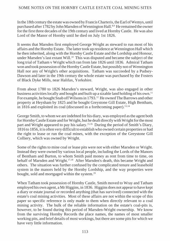
From this time there was a lot of activity, preparing the site for mining operations anda new engine house was to be built. In 1831 Smith recorded the following:-
“Jan 8th. I was with the men in the High Woods breaking stones and atFarleton Colliery where John Holdin (sic) and men were scabbling stones forthe Engine House.”
“Jan 14th. In the afternoon I went to Hamstone Gill when Charles Heaps andWilliam Hodgson were getting stones for Binway (sic) for the Steam Engineat Farleton Colliery.”
“April 12th. I measured the masonry for the Engine House at FarletonColliery done by John Houlding.”
120

“August 25th. Engine commenced at Farleton Colliery.”
“Aug 27th. I went to look at Farleton Steam Engine which was working andpumping water out of the pit.”
The engine pumped until October when, to assist the work, Smith engaged CharlesHeap and William Hodgson to divert springs and the rivulet in Camp House Woodwhich were thought to be percolating into the coal works. The water in the old pit wascleared in January 1832 and on the 14th six men were employed to work below ground,getting the first new coals out of the seam. From this date Smith began to keep a regularcheck on the output. The colliery accounts were kept by the banksman, WilliamProcter, and Smith recorded regular visits and time spent “making up” the coalaccounts until 1836. In April 1832 plans were being made to open a new working. Anew shaft was being sunk by Procter and Hodgson who met Smith in the Castle estateyard to look at some old cast iron pumps to see if they were suitable for use. Thedevelopment work appears to carry on until March 1834 when Smith went to look overthe new buildings with John Eccles. In October his diary recorded, “..Nine men, twohorses and lads were sinking the new engine pit night and day...” It must be assumedthat the pit was opened and producing coal, as the colliery books for this site have notsurvived. Smith made no mention of any other activity until an accident, “3rd October1836 , when Charles Heaps, overlooker at Farleton Colly, [was] killed by beingprecipitated down a pit from the rope slipping on the turn tree.”
SOME NOTES ON THE HORNBY CASTLE ESTATE COAL MINING SITES
121

BRITISH MINING No.50
The diary references to the site stop here, which is odd as coal was being producedfrom an old shaft, another shaft was being sunk, and it was in production for at leastfive more years. The Hornby records do not show who was working on this site, whattype of equipment had been installed or the design of the engine house and pitheadbuildings, but we have further information from other sources.
A map by John Padgin and Thomas Cross c1798, with a scale 6 chains to one inch (seeMap Five) shows only one ‘coal pit’ in a croft (field No 44) behind the present day TollBar Garage (there was no building shown on this site at this date), a possible associatedpond, or another pit (field No 122/123/121 boundary) three fields to the east with anassociated water course, and a building (on the north wall of field No 47) on the lineof the south wall of the present day Engine House Wood, and lanes or trackways upto both areas.41 There was nothing but an open widened roadway/yard area on the siteof the present Toll Bar Garage (the building called “Gate House” on the 1887 OS 6"map).
Two pits and a shaft with an engine house are recorded on the 1845 Ordnance Survey6 inch map. Local information indicates that this engine house, which could be the onebuilt by Holding in 1831, was demolished into the shaft c1930 and no plans orillustrations appear to survive. Recent close inspection of the site found no remainsof any buildings, but there were three filled in shafts and four well-defined bell pits,with tracks up to the sites from the old turnpike road. These remains correspond withsome of the sites marked on Yates’ map of 1796, and later mapped evidence.Unfortunately, the farmer/landowner is currently filling in several pits and levellingthe sites as part of agricultural improvements.
THE TATHAM COLLIERY (WEST).The Tatham Colliery West site is located to the south west of the road fromWennington to Oxenforth Green, centred at SD620690.42 Here there are many bellpits, some quite large, abandoned shafts and some opencast workings, all in thevicinity of School Hill, Meggs Farm, Russell’s Farm, Parkside, Overends, Moorheadand Tatham Park.
Some of these mines were worked by the Hornby Castle Estate, but others appear tohave been worked by lessees or were in the ownership of local farmers and colliers.The sites extend over many acres (see Map Two) and include the following named pitsites:-43 Tatham Common, Meggs, School Hill, School House, Russell’s, Overhouses,Tatham Pits, Dugdale's, Barton's, Ridley's, Tatham Park, Collinson's, Parkside,Talbot's, and Hall's. All these place names, except Meggs, appear in connection withcoal mining in the Hornby Castle records or in Smith’s diary. The known workingdates are from before 1642 to 1841 and can be supported by good primary andsecondary sources.44,45 This colliery will be the subject of an article to be publishedby the writer in 1995.
Moorhead and School House are two other sites, adjoining Meggs, where there werecoal pits. When the shafts on the School House site were closed in 1845 new pits wereopened up further along the coal seam at Moorhead to the S.E. of the older workings
122

at SD620685. The older workings and the new ones are all marked on the 1845 6 inchO.S. Map.
Tatham Colliery sites belonging to Hornby Castle were working in the early 19thcentury. Dickson reported their re-opening in 1810, with the land assessment taxbeing reduced.46 Smith regularly recorded his activities in connection with them andmost of the records of the Hornby Castle Estate show income from the TathamColliery and others up to 1834.47 In a Hornby Castle returns book there are entries asfollows:-
“Collieries, Dr George Smith for the colliery account 1833, Feb 14th. Balanceof Tatham Colliery £172. 10s. 0d.” and “1834 Feb 14th Balance TathamColliery £60. 3s 4d.”
These returns are signed by George Wright and George Smith. One must assume thatthese collieries were successful and profitable.
George Smith’s Diary entries give us some useful information as to the Hornby CastleEstate's involvement at Tatham. For example, on the first page of his diary in January1819 he recorded “I went to Tatham Coal pit today”, and he made regular visits to viewand supervise the workings on behalf of Mr Wright (but never, it seems, for Mr JohnMarsden), to collect dues, make up the accounts, pay the colliers and pay nearbytenants for damages etc. Smith also gives information on working methods, who wasworking at the various sites, and items on adjoining pits. In 1819 he recorded::-
"January 19th. At Tatham coal pit, Thomas Bowskill measured the new shaftyesterday, called at Hall Barns.”
“March 13th. At Tatham coal pit in the afternoon, the men had gone thro a vein ofcoal and had got 10 or 12 which were upon the hill.”
“April 19th . I met Thos Bowskill and the Tatham Colliers at the Bridge End whenI let them the driving of the level at Tatham Coal Pit for 26 shilling the 10 yard.”
In 1820, he recorded, “February 5th, Settled with John Wildman & Co for wallingthe level at Tatham Coal pit. Mr Wright let to John Wildman the sinking of a shaftthere.” and “February 19th, I went to Wennington and Tatham upon the collierybusiness. The men commenced sinking the new shaft today.”
In these two years of his diary, Smith informs us that colliers were working for coal,finding it, sinking new pit shafts and driving levels which had walled sides whenopen.48 We also know that Thomas Bowskill was the collier in charge and that theyused oak wood for “backing”. John Taylor was engaged in Smithy works, and one ofthe shafts was in Dugdale's Field.49,50 Other shafts were in Barton's Fields, TathamPark, Collinson's Pit, Parkside House, Talbot's Field, and Tatham School.51-56 Twomen, John Wildman and Arthur Foxcroft, were employed regularly, possibly asbanksmen, to record the pits' production and sales after the death of Thomas Bowskill
SOME NOTES ON THE HORNBY CASTLE ESTATE COAL MINING SITES
123

BRITISH MINING No.50
on Sept 21st 1822. John Hodgson continued as Master Collier. Smith does notmention a banksman at Tatham until June 1824, when James Armitstead wasrecorded.57,58
There were some renovations taking place at Tatham Pit from late 1823 to May 1824,which Smith recorded as follows:-
Sept 12th 1823 “the wheel at Tatham Pit removed today.”Dec 9th 1823 “John Wildman brought a turn tree from Tatham Pit and got
it lined.”March 2nd 1824 “Benjamin Beckett and Alexandra Caton called to apply for
situations at Tatham Pit, Thomas Blezard and John Nicholsontook tools.”
April 15th 1824 “... then to Tatham Pit, E. Knowles finished timbering the pithouse and they should get the wheel on the hill today.”
May 29th 1824 “Went to Tatham Coal Pit. Balderstones horse commencedpulling coals yesterday there.”
There are also some seemingly contradictory entries in the diary, as follows:-
May 17th 1824 “went to the engine house at Tatham where we broke up 42cwt of old cast iron for some potters.”
May 24th 1824 “James Stephenson fetched the boiler of the steam engine atTatham Colliery to Hornby on his waggon.”
May 29th 1824 “Old Knowles called about the Tatham fire engine.”Sept 25th 1824 “The horse gear, wall and house, the wheel rope to be
burned down at Tatham Colliery.”
It seems to the writer that Smith was referring to two sites in the area, one calledTatham Pits, which had just been renovated, and the other called Tatham Colliery,which at this time was being discontinued.
In 1827-8 more problems befell the Tatham coal-pits. For example, on February 27th1827, Smith recorded “James Armitstead banksman at Tatham Pit died”
In 1828 there were problems with water, which Smith chronicled as follows:
“Feb 7th 1828. John Wildman called upon me at R. Ripleys found that he hadbeen down in Tatham Pit that Collinsons men had opened the Dam in ourworks and let off the water. I called upon Miss Collinson in the evening whopromised to send for S Redshaw and rectify the business.”
Water seemed to bedevil the colliers regularly, as Smith made many entries referringto water problems in the pits.59 The foregoing accounts show that the coalworkingsof the various owners and operators on this site were very close together andinterlinked within the system, which obviously needed some modicum of cooperation
124

and joint management if the operations were to be successful and profitable. Tathamalso had cinder ovens on the site. These produced cinders for sale to the localpopulation and in particular to the millers and maltsters for use in their drying androasting kilns.60,61
SOME NOTES ON THE HORNBY CASTLE ESTATE COAL MINING SITES
125

BRITISH MINING No.50
TATHAM EAST COLLIERY.These sites are named as Blands, Perry Moor, High Botton, Robert Hall, andClintsfield (see Map Six).
Clintsfield Colliery, at SD629698, appears to have been worked from at least 1772,as there is a lease dated 1782 in Hornby Castle Muniments records which names thesite and gives evidence that it dated from 1772. A lease was made on 19th August 1782between Francis Charteris, Lord of the Manor of Hornby and Tatham, and John Martin(of Arkholme, yeoman), John Atkinson (of Littledale, yeoman), Edward Martin (ofTatham, collier), and William Storrs (of Tatham, collier), who gave up an earlier leasedated 13th February 1772 for the new lease “for all colliery, coal mine, seam and seamof coal now opened at Clintsfield, now in their possession”. The partners paid £21in two equal payments per year.
There are only four colliery sites, at Clintsfield, (see below) Farleton, Tatham andSmearhaw, which are known to have had steam powered mechanically-driven liftingor pumping gear at the pit head, together with an associated range of buildings, cinderovens and other works, with access roads.62-65 Only one set of these pithead buildingssurvives at Clintsfield Colliery (SD629698). Here the last range of colliery buildingsis extant with an engine house of 1839, an adjoining earlier building, traces of a pond,a water race, and a roadway with a river bridge to the north, and to south and west bellpits, or older shaft heads with spoil heaps. This appears to be one of the more lastingand extensive of the lower Lune valley-Wenning workings. It was first recorded inthe lease of 1772 and is on Yates’ map in 1786 as a working coal mine with a buildingand water wheel (possibly just a pithead wheel).66 Surviving documentary evidencegives some insight into the workings over a period of time. For example, the mine wasworking when Yates surveyed the area in 1785 and it was still open in 1822.67 The pitwas raising coal and producing cinders for sale in 1835 and the site was still workingin 1836.68,69 The surviving stone buildings are later structures, not the ones that Yatessaw, nor the first on the site, as the present stone engine house building was erectedin 1839 for the Lessees by Arthur Burrows, who lived at Blands Farm.70
Since the mine closed, this Burrows building has been altered and appears to havebeen used as a dwelling before it was abandoned and left to decay. The completestructure once housed winding/pumping gear, with a steam boiler to provide power fora steam-driven engine. This was on site in December 1839, when the mine was stillworking.71 The buildings on the site were recorded by the writer in 1967, and surveyedand measured with J.W.A. Price in 1980 for the publication of the latter's work on theLune Valley.72
The extant but ruinous engine house is the one built by Burrows in 1839. It is set ina hollow and joined to the earlier buildings, surrounded by what appears to be the pit'sspoil. The east gable is built mainly of cut stone blocks. The rest is random freestonewith cut quoins. The adjoining boiler house has what could be a contemporary square-built chimney attached at the south west corner. This still stands some 18 feet tall andmeasures 10 feet square, but is now roofed with stone slate. This and the rest of the
126

building range are thought to be earlier than the Burrows' addition and all are withoutroofs. The engine house measures 18 feet by 19 feet and is some 20 feet tall with intactgables. It has an upper arched opening for the gear, but this has been partly walled totake a later square window and a lower doorway in the east end. There is a windowand a doorway with traces of a porch on the south and upper and lower windows inthe west gable. These were possibly cut when the building was converted to a house,as evidenced by some surviving internal plastering, fireplaces and floor joists. Thereis an original doorway in the lower part of the north wall giving access to the boilerhouse. The roof was stone slated, but all but the eaves-wallheads have gone. Oneinternal wooden roof truss and some cast iron pieces were still on site in 1967. Thelean-to boiler house to the north measures 40 feet by 13 feet and has cut quoins withrubble walling. There are no gables or windows extant. The east wall has gone andthe wall tops are crumbling, but the size is given by the foundations. The base of thenorth wall has burnt stonework inside and is slightly concave where the boiler washoused. The pit shaft is seen as a depression on the east side and there are remains ofa banked pond to the north. To quote Price, “The complex closely resembles a Cornishbeam engine house of the type used to lift water out of mines.”73
R.W. Dickson, in his reports published in 1815 (on notes possibly made several yearsearlier), gives a general description of the “Tatham Mines”, which were working withshafts up to 70 yards deep, and several other works.74 One he calls the Tatham pit couldwell have been Clintsfield, or he could be referring to the School Hill/Meggs Farmarea workings found further to the west.75 He stated that it had been out of use for sometwo years and was owned, as were several others in the locality, by John Marsden ofHornby Castle, who operated them through his agent or leased out the sites.76
An unreferenced pamphlet of March 16th 1889, titled “Decayed Industries of Wray,The Coal Trade”, appears to refer to some activities in the area some 50 yearspreviously. It states that Clintsfield was being worked by “Mr Roughsedge ofBentham, and here some Wray colliers found employment.”77
Harris (1969) states that Clintsfield was leased in 1845 to the Sergeantsons, ownersof the Ingleton pits.78 As it was in competition with them for supplying coal to the localmills, they promptly closed it down. Another possible reason for closure was that ithad only a two foot seam of inferior coal, compared with the good quality 4 foot and6 foot seams at Ingleton.
In contradiction to the latter, there is an article in the Lancaster Gazette, dated March31st 1855, which reports the re-opening of the Clintsfield Colliery. Perhaps theSergeantsons’ lease expired and the owners, possibly Pudsey-Dawson of HornbyCastle Estate, re-let or re-opened it themselves.
Nevertheless, Seward and Hindley were working the mine when it was advertised forletting in the Lancaster Guardian, July 12th 1856, as follows:-
SOME NOTES ON THE HORNBY CASTLE ESTATE COAL MINING SITES
127

BRITISH MINING No.50
TO BE LETFor a term of years, from the 1st. Sept next all that
COLLIERY, OR COAL MINE.Situated at Clintsfield, in the Township of Tatham, in the County of Lancaster, in theoccupation of Messrs Seward & Hindley as tenants thereof. The taker will have theoption of purchasing at valuation the Steam Engine, Pump and other Apparatus nowupon the Colliery. The Coal is of excellent quality and the works, which are in fulloperation are immediately contiguous to the North Western Railway.
For further particulars, application may be made at the offices of Mr Dunn, Solicitor,Lancaster, or to the Assignees of Mr Seward on the premises.
It has not been possible to ascertain whether this site was let or if it worked onregardless, but it seems probable from the description in the above advertisement thatthis site is the one where the engine house is still extant. The next mention of thebuilding is in the 1861 Census of Population which lists under Tatham the “EngineHouse, at Clintsfield, occupied by John Travis aged 33 Agricultural Labourer, hiswife Ann aged 29 and their three children, William aged 13, Robert aged 12 and Jane5 months.” We have to assume from this evidence that the site was no longer workingcoal and that the building had been converted to a dwelling for the Travis family,leaving the evidence of domestic use we see on the site today.
A map, taken from the Tithe Plan of 1848, but made before the railway works began,is in the reference section of the local history collection at Lancaster Library. It showsthe site in field number 466, with a pithead building, but not the “Burrows” enginehouse, a depression and a pond to the north, and a road leading down to the river whichis crossed by a bridge at SD631700 (see Plan Two).79
Clintsfield Buildings, Tatham, 1993 (P.J. Hudson).
128

The first edition Old Series 1 inch Ordnance Survey map of 1842 marks the placename Clintsfield, but records the colliery site as “Blands Colliery”, a place name notoften mentioned in the local documentary record.80 In contrast, the first edition
SOME NOTES ON THE HORNBY CASTLE ESTATE COAL MINING SITES
129

BRITISH MINING No.50
Ordnance Survey 6 inch, surveyed c1841, with later revisions, shows extensive “OldCoal Pits” and names the general area “Clintsfield Colliery (disused)”. It marks eightof these with circular and square symbols, with the “Burrows buildings” marked andshown with a semi-circular pond to the north.
The Hornby Castle records shed little further light on this site, even though, as the Lordof the Manor, Marsden held the coal rights and possibly set out the leases, or gave partor all of the moiety to the local church living.
The Clintsfield coal worked here is in the Sabdenian which contains the ClintsfieldGrit. This is a rock deposit some 45 feet thick, containing several coal seams. It is thelowest member of the Bentham Grit Group and forms the top of the Sabdenian,outcropping between the rivers Roeburn and Hindburn where it is seen as a fairlycoarse felspathic sandstone. To the north, it becomes flaggy at the lower end andganisteroid near the top, with the two foot coals appearing in the middle. This seamis termed the Clintsfield by Moseley.81 John Phillips also comments:82
“After much examination, I am of the opinion that there is probably but oneseam of Coal worked in all the Country South of the Wenning-for theClintsfield Coal rests on the same Grit rock as the Coal of Smear Hall,Farleton &c,; and there is no room for doubt that the Coal of Bentham, andGrestone-gill,(sic) is the same. The differences of quality and the thicknessbetween them are not unusual in Millstone Grit Coal. Indeed the smallnessof the variations to which this Coal is subject appears to me remarkable. Itsthickness I believe never exceeds 20 inches, and hardly ever fall short of 15.”
Coal has been worked along a line south of High Bentham and across to Crossdale.This line also extends northwards into the valley of the River Greta. For the most partit is of very inferior quality, except perhaps where it was mined at Blands Farm,Clintsfield, Tatham, and High Bottom Colliery sites and the sites just to the south ofHigh Bentham (SD665685), at Moulter Beck (SD 664 685), High Botton, Coal-pitsClose, Lanefoot and Greystone Gill.83,84
In Moseley’s paper there is a section [fig. 8] of the Bentham Grit Group at Mewith.85
The core logs show the coal-associated strata quite well, with the Clintsfield Coal setin a narrow band of grits below the coarse, red, false-bedded sandstone and the otherBentham Grit Group elements of the Kinderscoutian strata of the Wenning Valley,lying above the Crossdale Shales (see Figure One). Perhaps it is because of the depth,the thickness and the slightly better quality of the coal in this area that the Clintsfieldsite was the only one on which any well-made permanent structures were erectedwhich survive today. Deep mining needed this type of investment and the location isnow isolated from the present road system by the construction of the railway line andthe resultant changes in the course of the river Wenning at this point. This could bea factor which has helped to preserve the site.
130

The above information suggests who was leasing and operating the Clintsfield siteover its working life. In 1772 it was the partnership of John Martin, John Atkinson,Edward Martin and William Storrs. In the 1830s it was leased by Arthur Cort ofLowgill, who also had High Botton Pits and possibly some others. Around 1840 MrRoughsedge of Bentham worked it. He was the owner of the Bentham Flax Mills. Itwas leased in 1845 to the Sergeantsons of Ingleton Pits. Messrs Seward and Hindleywere tenants before 1856.
SMEAR HALL.This colliery, which is often called 'Smearshaw' or 'Smearhaw' in the archives, ismostly in Roeburndale township. It is centred on Smear Hall (SD622670) and runsto the north near Birks to the west bank of the River Hindburn, and to the south ofSmear Hall by Scale, Hunts Gill, Lanedyke and Stauvins and then due west intoBowskill's Wood and the river Roeburn’s eastern bank. Most mining appears to havebeen done to the south of Smear Hall. It included Outhwaite and Wray Wood Moor,but these are discussed as a separate mining area.
Dickson commented on the area in 1815 as follows: “thin beds of coal in the northernrange, seem but little broken or disjointed, about Farleton, Smeer-Hall and Tathambeing formed in many different places.86 The collieries are there wrought inperpendicular shafts and belong to Mr John Marsden Esq, but the Smear Hall pitsare only worked at present, and the water is taken off having a level driven up to themand appropriate machinery.87 The shafts at these pits are about 70 yards deep: thebed of coal is 18 inch and produces upon average daily, when in full work, about 300loads, or 900 Winchester bushels. The other Colliery are not now wrought. Farleton
SOME NOTES ON THE HORNBY CASTLE ESTATE COAL MINING SITES
131

BRITISH MINING No.50
has been discontinued for the last 10 years, and will require a fire engine (poweredby steam) to carry off the bottom water, when in work, produced about 500Winchester bushels daily.88 Tatham has not been worked during the last two years,the bed being run out, and not yet recovered: but it then produced about 900 bushelsa day. The shafts at both these last mentioned places are about 50 yards deep, thethickness of the bed at Farleton is 18 inches and at Tatham about 2 foot 8 inches”.
The Smear Hall Mine area is worth discussing in some more detail. It might have beenworked in the mid to late 18th century and is known to have been worked for the first50 years of the 19th century. There was then a possible break in activity, before theworkings were reopened. They finally closed in 1882.89 The site contained a seriesof mineworkings situated on the Tatham-Roeburndale parish boundary, betweenGoodber Beck and the River Hindburn. The main sites were just south of Smear Hall(SD624658) and near Hunts Gill Beck (SD613651), where three shafts are recorded.The only accurate map on record is the abandonment plan dated 1882 (see PlanThree).
The mine had mixed fortunes, with times of good working and times when the coal washard to get, a feature not uncommon in the Lonsdale area where there was faulting,lensing and down-throwing, excessive water and road access problems.
To understand this, one needs to examine in more detail the geology of the Smear HallCoal Seam and the Smear Hall Fault. Prof Phillips’ report of 1837 mentions a thin coalseam found in several hundred feet of the “Hard Gritstones” ... “as may be seen atOuthwaite in Roeburndale and at Crag Moor in Hindburndale, rests a series ofvariable gritstone rocks enclosing two Seams of Coal, the lower one worked at SmearHall, Tatham &c. Above these Coal-seams and their containing rocks comes aconsiderable thickness of argillaceous Strata with bands of Ironstone which maywell be seen about Smear Hall, and in Littledale, and some thin hard gritstone rocks.Above all these, which may be considered as belonging to the Middle Millstone Gritseries, lies a great thickness of coarse Red Grits, Plates, and thin Coal Beds, (as maybe seen in the Greta); and these support the Coal formation at Ingleton and Burton(No.7): this being covered by the Red Sandstone and Conglomerate of Thornton andWest Houses (No.8)”.90
The use of Moseley’s recent geological survey work gives further explanation, thefollowing information being extracted and collated by the writer.91 The downthrowin this case is to the south, reaching a maximum of 700 feet in Crossdale. Thedepression of a wedge-shaped area between the Smear Hall Fault and the branch ofthe Stauvin Fault (SD610660) in Roeburndale has, however, resulted in some scissormovement with the pivot north-west of Smear Hall (SD620661). Thus in Roeburndalethe downthrow is locally north. The fault can be followed for some seven miles fromFarleton, where it forms the northern boundary of the old coal workings, to upperCrossdale. It varies from a single fracture between SD605665 in Roeburndale toSD671651 in Crossdale, to a faulted flexure in which the folding is more importantthan the actual fracture at Hunts Gill, to Colegate Scar (SD644659) where it disruptsthe coal seams. So the Stauvin fault forms the southern limit of the colliery. As the
132

SOME NOTES ON THE HORNBY CASTLE ESTATE COAL MINING SITES
133

BRITISH MINING No.50
downthrow of this fault can reach 200 feet in places, this would cause problems infinding the coal again and could involve the sinking of a new shaft making furthermining uneconomical on such a poor coal-seam. The Smear Hall Colliery is theeastern limit of the Stauvin fault and also the limit of the 13 mile series of faults whichruns from Morecambe Bay to north-west of Caton and then to the Upper BrennandValley.
In Bowskill Wood there is a nine inch seam of Crow coal at 30 feet and the 2 foot SmearHall Coal at 50 feet under a sandy shale bed, but topping the lower Roeburndale Gritbed. Hunts Gill has a three inch Crow coal at 6 feet in a 15 foot Roeburndale Grit andthe two foot Smear Hall Coal 45 feet below this in a sandy shale, not in a RoeburndaleGrit band which is absent. The Park House area has Crow Coal at 10 feet inRoeburndale Grit, and County Beck has Crow Coal at 10 feet, again in RoeburndaleGrit, plus several bands of mixed sandy shale and grits before the two foot Smear HallCoal is shown at 80 feet below the Crow. This overlies sandy shales, and is again notin a Roeburndale Grit bed (see Fig Two).
This, with Dickson’s information, implies that there was a good seam of coal and thatit had been mined during the early years. This is supported by primary evidence andby Smith’s Diary entries etc until the abandonment in 1882.
The Hornby Estates Collieries Accounts Book has entries for the Smear Hall Colliery,in Roeburndale, from 1834 to 1838.92 For example, on February 14th 1835, it records,“To balance of Smearshaw Colliery Book £54.12s.5d.” with other entries, all signedby George Wright and George Smith.
134

The Smear Hall colliery site had a large number of bell type and some opencastworkings along Hunts Gill Beck and there is still evidence of a shaft at SD624657.There are no extant buildings, only traces of foundations, with spoil heaps andassociated roads. This site has to be considered as separate from the workings furtherto the west on Wray Wood Moor. The largest of the shaft workings is presumed tobe at SD62356575, with the site of the cinder ovens close by.93 According to avaluation of damage on Thomas Parker's estate at Stauvin, dated February 7th 1843,there were three pits in operation, named Deep Pit, Rise Pit and Low Pit withconnecting roadways.94 Rise and Deep Pit are in Over Hill Field, Low Pit and thenewly made road are in Great Paddock, and the total amount of damage is given at 2roods 32 perches and 16 yards at £35 per customary acre. The total damage is,therefore, calculated as £24 11s 0d.
The place named sites where there is evidence of coal workings are Smearshaw DeepPit, Bowskill's Wood, Scale, Troughton Pasture, Lane Dyke, Harrison's, Bellhurst andCragg Moor and Stauvins.95-101 We are perhaps fortunate that George Smith takes alot of interest in these coal-mines, and his diary is full of information as to what wenton during to first part of the 19th century. It would be impossible to use all theinformation Smith gives, so below is a selection which best illustrates these activities.The first entry is on January 21st 1819 when Smith wrote, “settled with ThomasBowskill for his share of Smearhaw Colliery for 1817 and 1818.”
In September there were problems with roof falls “in both shafts”. The rest of 1819concerns cutting oak wood for colliery works, props, linings and backing, and Smith'skeeping and settling accounts. In 1820 there were some problems about abuse of“turns for coals”, and there was a problem of a deficiency of coal laid on the heapowing either to bad management or to dishonesty.
In 1821 there were problems with “the wheels”. One was moved and repairs weremade to another. In 1822 the rise shaft “failed its coal” and the men were moved towork another shaft in February. There was also a reduction in wages for the men whosent John Eccles to see Mr Wright about the matter. Other activities involved ThomasCharnley, Joseph Gill and John Hodgson who “bored thro the Coal in Troughtonpasture, thickness of the coal estimated at 19 inches, depth to it is 50 yards.” Thencame a tragedy. Thomas Bowskill, the master collier, was taken ill, and Smith had toassist with accounts and paying the banksmen etc., and on 21st September Bowskill,the master collier, died at 71 years of age.
This event appeared to change the management on the sites as two men, AnthonyBateson and Richard Brown, were officially appointed banksmen and from this timemade regular visits to Smith at the castle with their accounts. Brown and Hall carriedon in these posts until early 1828 when the year end accounts for the pits showed adeficiency of 996 loads. It is assumed that they were dismissed, but Smith makes nofurther comment, only that on January 28th William Saul was recorded as banksmanat Smearhaw. Saul carried on in this post until November 12th 1836, when Smithrecorded “I engaged George Wildman as Banksman at Smearhaw Colliery, he andhis father William Wildman signed an engagement today.” As Smith made no further
SOME NOTES ON THE HORNBY CASTLE ESTATE COAL MINING SITES
135

BRITISH MINING No.50
mention of any changes, we have to assume Wildman stayed in this post until thediary's reports on the coal-mines end in 1839.
There are no detailed accounts of production figures for coal from these pits, butregular entries in the diary refer to cart-loads of coals being carted from the pits tovarious customers. For example, coals were regularly carted to Heysham, BenthamMill, Wray, Hornby and Kellet. Most of the coals from the site were collected by thebuyers and paid for on site or by credit arrangements with Smith, who on occasionswithdrew this and stopped credit at the pits.102,103
Another constant problem on the Smearhaw site was discontent amongst the minerswho asked for better pay, but did not always get it. Smith recorded several instancesof this as follows:
“March 14th 1825, Smearhaw colliers called about an increase of price ingetting coal.” and again “December 5th 1825 , Smearhaw level drivers calledto ask Mr Wright to make up their wages to 2/6d per day for their last lengthof level driving, he promised them something at Christmas.” On January 17th1826 he recorded “Smearshaw Level Drivers called and refused to drive thelevel at 30/- per yard except E. Wilcock who agreed.” The next day, he wrote“E. Wilcock and S. Newby commenced working the Smearshaw Level.”Another dispute was recorded on February 7th 1829: “Robert Wilcock,Thomas Berry and Charles Ronson were dismissed from driving SmearshawLevel by me after consulting Mr Wright; they had had 11 shillings a week andthey wanted 14 shillings a week each and they were 6 yards short ofcompleting their agreement.”
Roadways were also made up to the coal pits and works. These were almost alwayslet out to tender. There are no surviving official accounts or maps for this work, butSmith mentioned some details. For example “Jan 22nd 1828, Mr Wright and I settledsome accounts including Wennington Mill. We let some road to make at Smearhawto Thomas Towers of Above Beck for 30/-” “June 7th 1829, I paid John Berry £1 10s0d for making a road at Smearshaw Colliery.” “Jan 22nd 1831, John Hodgson andArthur Howson called when I paid the latter for making a road at SmearhawColliery.” “May 19th 1832, I went to Tatham Colliery and set out a road there whichI let to make to William Hall in Talbots large field.” (see Map Two).
There is an abandonment plan for Smear Hall Mine, dated 1882, NMRS reference J/M 233, scale to 1/10,560 (see Plan Three). This has a section and plan of ancientworkings and the last seams worked. viz: “The two pits 13 & 16 yards in depth, workedand finished in 1882 by Mr T.B. Kayes and his executors.“
The other old pits in this detached coalfield were worked by Mr John Newby whoworked the colliery before Mr Kayes. The section shows soft black shale and two bedsof calcareous ironstone, each about one foot thick, about 30 yards deep.
136

SOME NOTES ON THE HORNBY CASTLE ESTATE COAL MINING SITES
ft inGrit Rock 7 9Coal 0 6Grit 7 0Shale 3 0
Coal 18" & 20" & 24", and 1ft 9ins and grit rock 10ft 0in. Shale bored into for 120feet and not at bottom. Faulted dip is 1 in 7. and an adit adjoining river. The coal pitsare shown and part as “not got”, between Gill Beck-Lane House and Birks with twoadits on Birks side.
OTHER SITESOther sites of sporadic coal mining on the Hornby Castle Estate are at Balshaw onTatham Fells and near Salter and Harterbeck in Roeburndale. The latter are at LowerSalter and High Close where there are signs of hand-pits and other coal workings.From the few scraps of surviving documents, it is possible to deduce that coal wasworked under Wright's and Smith's management from 1830 to 1835.
In December 1830 one Thomas Procter agreed with Wright, for the sum of £20, todrive and cut to coal in Lower Salter Close opposite Harterbeck. On the 29th Smithwrote in his diary, “I went to Lower Salter before close and met there Thomas Procterof Ingleton and Joseph Gill and John Hodgson to examine a coal there pointed outby Thomas Procter, it was only from thirteen to fourteen inches thick.” In February1831 Smith wrote “Mr Procter called about no coal at Lower Salter Close when I paidhim £5 for the time and costs he has been at about it and we are to try for it ourselves.”Later on the 24th he recorded “I went to Lower Salter Close when William Johnsonand Thomas Berry were trying a coal there, John Hodgson was with me.” The siteis not mentioned again until December 1833, when he wrote “John Eccles calledabout Salter Colliery.” Similarly on March 14th 1835, he recorded “Thomas Gillcalled about Over Salter Colliery.”
There is also sparse information about the Balshaw site as it was always leased out.The first mention of it is in 1819 when Smith recorded “28th January James Berry Srand Jnr called and took Balshaw Colliery for 7 years at £30 per year.” Another entryreads “November 24th, John and James Berry of Nutgill called and paid half yearsrent for Balshaw Colliery, they said they would give it up.” The only other mentionis dated Wednesday February 3rd 1820, when Smith recorded, “I received a notice inwriting by Thomas Berry that Berry’s quit Balshaw Cottage (Colliery).” BalshawFarm, Tatham, is at SD655669, and the Tithe Schedule for Balshaw refers to a “CoalPit Meadow”, which is next to Crossdale Beck, opposite Moorcock Farm. It ispresumed that the Berry family could not make the pit pay, but they did not disappearfrom the scene as they took on colliery work and road making on other sites (seeelsewhere). This Balshaw site is mentioned in odd fragments of documents in theHornby Muniments, and there is a connection between the site and Arthur Cort whois known to have had several coal mining interests in the area. In one item Cort wasat Balshaw Colliery in Tatham Fells from which he sold some iron cylinders in c1823.Arthur Cort of Lowgill keeps appearing in the coal mining records for the area (see
137

BRITISH MINING No.50
elsewhere). He was connected with Clintsfield, and was in partnership with othercolliers. He worked a mine near Tatham School in 1827 and there is a reference inBundle 70 of the Hornby Muniments, in an account dated 1827, viz: “Paid by ArthurCort of Lowgill to John Wildman and by him to George Wright, to stopping anddamming water let into the works of Tatham School Colliery by you men, self and lad7days to £1 3s 4d, John Newby and lad, 3 days 10 shillings, Total £1 13s 4d.”
For other references to mining activity in the area, we have to turn to other primarysources. The Tatham Parish Registers for 1750-1800 give coal mining as theoccupation of 16 out of 122 bridegrooms registered in the period. This number is onlyexceeded by those employed in agriculture.104 The last mention of coal mining in theHornby Estate Lands is found in an article in the Lancaster Guardian dated May 24th1946, when a deposit of coal was opencast.
CONCLUSION.The evidence to be seen on the ground today on most of the sites discussed above isvery scant. With the exception of the substantial ruins of Clintsfield engine house,most of the other remains consist of spoil heaps, filled bell pits, narrow metalledroadways and odd traces of building foundations near the shaft heads etc. None of thesites inspected had any signs of artifacts or rusting metalwork which could beassociated with coal mining. There is much more evidence to be found on these siteswhich need more intensive study and recording, a situation which the writer hopes torectify in the near future.
This paper has, for brevity, had to leave out much of what there is in Smith's Diary andother sources, having just selected items to help assist the interpretation of a site or tomake a point. The research work is still going on. Many more coal mining relateddocuments are known to exist, and every effort will be made by the writer to gainaccess to them in the hope of being able to elucidate further on these and other LuneValley mining activities.
REFERENCES1 This paper is a part of a major work beingcarried by the writer researching, recording andpublishing all the minor coal working sites in theriver Lune catchment area.
2 Ford, T.D. The Ingleton Coalfield, QuarterlyJournal of the Geological Society of London, VolCX, part 3 (December 1954) pp.231-264.
3 Harris, A. The Ingleton Coalfield, IndustrialArchaeology, Vol.5 No.4, 1969, pp.313-347.
4 Price, J.W.A. The Industrial Archaeology ofthe Lune Valley, Centre for North-West RegionalStudies, Occasional Paper No.13, University ofLancaster, 1983, pp.38-46.
5 Ashmore, O. The Industrial Archaeology of
North-west England (Manchester: MUP, 1982).
6 Chippindall, W.H. A 16th.c. Survey & YearsAccounts of the Estates of Hornby Castle. 1939.Chet Soc, NS., Vol 102.
7 Bentham Pits and other nearby mining areaswhich were not under the direct management ofHornby Castle or controlled by the estate as Lordsof the Manor, will be discussed in another paper tobe published in 1995.
8 Baines, E. History, Directory and Gazetteer ofthe County Palatine of Lancaster. Vol 11. (London:Longman, Hurst & Co., 1824) p.664.
9 In Hornby Castle Muniments there is a lease fora coal mine at Clintsfield dated 19th Aug 1782
138

SOME NOTES ON THE HORNBY CASTLE ESTATE COAL MINING SITES
between Francis Charteris, Lord of the Manor ofHornby and Tatham, and John Martin and others.
10 Chippindall, W.H. History of the Township ofGressingham (Kendal: Atkinson & Pollit, 1919)p.60. Note: George Wright is also listed at TheBarrows, Heysham, in Baines, op.cit., 1825.
11 Wright is mentioned as a partner at MeggsColliery in 1781.. Ex documents found in HornbyCastle Muniments, unlisted.
12 Chippindall, W.H. 1919. op.cit. page 60.
13 Baines, E. 1825 op.cit. page 661.
14 Smith's Diary op.cit. page 3.
15 Copy Mr George Smith’s Diaries, Bound inVols 1 to 4, pp.875, Copied in longhand by unknownhands on lined paper watermarked “Monckton1878”, page 444a watermarked “Partridge & Cooper192 Fleet St, 36.” unpublished. Referred to furtheras “Smith’s Diary”.
16 There is evidence in Smith’s Diary that he toowas engaged in various small scale business on hisown account from time to time.
17 Smith’s Diary. Sept 15th. 1823. page 152. “Iwent to Smearhaw Colliery in the afternoon andpaid Mr Marshall a years rent for Mr Wright.” and“December 13th Friday 1822. Francis Pearsoncalled and left a deed respecting coal in SmearhawEstate belonging William Wilson.” and “11th Feb1823. Mr Francis Pearson called and Mr Wrightpaid him £50 the balance due to William Wilsonand others for coal in front of Smearhaw Estate.”
18 Smith’s Diary. Dec 11th. 1830. page 340. “RKirby Schoolmaster of Tatham called and I paidhim half years rent of Tatham School viz, WilliamHalls £6.6.0 and George Banks £6.15.0. total£13.1.0.”
19 Meggs Farm area where there are collieries is anexample. The freehold of this land, Meggs, wasprobably granted out by the Lords before 18 EdwardI and the Statute Duca Imptores. It must have beengranted out prior to any custom having attachedagainst the Lord etc., otherwise it would have beensubject. Apart from direct ownership, some landsare: 1. Ancient freehold, 2. Feefarm, 3. Customary.One would expect in all cases that the right to thecoal would, however, be held by the Lord of theManor, unless specifically sold off or vested inchurch lands.
20 A Rental document, Elizabeth I, 1565.
21 Chippindall, W.H. A 16th C. Survey & YearsAccounts of the Estates of Hornby Castle. 1939.Chet Soc, NS., Vol 102.
22 Lancashire Record Office. DDGa 23(2).
23 Estate Account Book, Hornby CastleMuniments. page 58.
24 ibid. 1661. page 133.
25 These are the old mines on Tatham Moor, laterknown as the Tatham Colliery, but do not includeSchool and Meggs which were only opened up inthe late 18th century.
26 Lancashire Record Office. DDX/404.
27 Ellin Collinson tried to prevent the scheme ofthe four partners George Wright, John Atkinson,Thomas Towers and William Bond, and served awrit, but the work appears to have gone onregardless.
28 Hornby Castle Muniments. Ex papers in trunkNo.18.
29 George Smith was the agent of Marsden andWright of Hornby Castle Estate.
30 Fisher's pit appears to have been unsuccessfulas he sold up in 1822. Smith’s Diary, page 107.March 29th 1822. “Went to Henry Fishers sale atThimble Hall in Tatham.”
31 The Edmondsons of Outhwaite owned some ofthe Wray Wood Moor Coal seams adjoining theHornby pits, and were often in dispute with HornbyCastle Estate over these sites. (See evidence undersite name elsewhere).
32 Clare, J & Hudson, P.J. Notes on Coal andCoalmining in Western Lunesdale and Quernmore.Contrebis Vol.13, (1986/7), pp2-17.
33 Potts, Prof. W.T.W. The Origin of GresgarthEstate and the Date of Gresgarth Hall. ContrebisVol 11, (1983), pp.26-31.
34 Price, J.W.A. The Industrial Archaeology ofthe Lune Valley, Centre for North-West RegionalStudies, Occasional Paper No.13, University ofLancaster, 1983.p35.
35 Baines, op.cit page 663.
139

BRITISH MINING No.50
36 Smith’s Diary, page 349. May 30th. 1831.“James Hind, Richard Smith and I took thepopulation of Hornby Number 383, viz 193 malesand 190 females being 94 less than the census of1821.” Showing a slight error in someone'sarithmetic!
37 Smith’s Diary, “Feb 16th 1823. Richard BrownBanksman and John Wildman cinder burner fromSmearhaw called with there accounts, making outcolliery Bills all day. Feb 17th 1823. I went toGreystone Gill Colliery the men commenced sinkingtoday, called at Bentham Mill and recieved bill forcoals off Mr Overend. Feb 19th. I went to TathamPit to R. Drydales, Wm Maudsleys Wennington.Feb 20th. I went to Smearhaw Colliery to look atthe damages and collected for coals in Wray.”
38 Hudson, P.J. The Wray Moor Colliery Dispute,in Contrebis Vol 19, 1994.
39 QSB/1/270. 17 Quarter Sessions lists has apetition for settling the ownership of coalmines inFarleton and Claughton, dated 1646.
40 Dickson, R. W. A General View of theAgriculture of Lancashire: with observations ofthe means of its improvement. (Shepwood, Newby& Jones, 1815), p64-8.
41 Lancashire Record Office. DDHH 135/364box 2; Map ‘G’
42 Tatham Colliery East is to the north east of theroad from Wennington to Oxenforth Green andincludes the named sites of Clintsfield, Blands,Perry’s and Robert Hall.
43 Lancashire Records Office. Map DDHH B 38.A map of Russell’s Farm, Tatham. c1830 shows 12‘old coal pits’, an extensive trackway, road system,old quarries and wells, all west of School Hill Farm.
44 Hornby Castle Muniments. Account Book p.58,1642. “Item 3. The colemine in Tatham Common inprobability may be of much greater value ifsettlement of ye estate and industry applied.”
45 Smith’s Diary. Page 557 May 4th. 1841.“David Gifford called about the measurement ofdamages by Tatham Colliery to her farm.”
46 Dickson, R.W. op.cit., pp68-78.
47 Hornby Castle Muniments, Colliery note books1834-38.
48 The writer has visited Blands Farm and seentunnels connected with the old coal workings whichhave the sides stone walled and the roofs lined withlarge flat stone flags.
49 Thomas Bowskill was collier in charge of theHornby Estate pits at Tatham and Smearshaw. Hewas also involved in other pits connected withHornby Castle, or with Wright, e.g. Greystone Gill.Every Saturday, the ageing Bowskill collected thecolliers’ wages from Smith until John Hodgson,another master collier, gradually took over.Bowskill might have had a share in the workingswhich dated back to the 18th century leases. Healso had an interest in Smearshaw Colliery, againas chief collier, as a diary entry of January 31st1819 shows: “Settled with Thos Bowskill for hisshare of Smearhaw Colliery for 1817, 1818.”
50 Smith’s diary November 18th 1820, “the menbegan boring the present shaft in Dugdales Fieldon Monday last.”
51 Smith recorded this shaft being sunk beforeMay 1822, as the level was being driven then.
52 “Jan 5th. 1827. John Wildman and JamesArmistead called having opened a Coalpit inTatham Park.”
53 Smith’s Diary. “Feb 11th 1828. William Halltold me that the Colliers had left Collinsons Pitbeing ordered away by Miss Collinson.”
54 An unreferenced newspaper cutting of c1890,in possession of Mr D. Hartnup of Wray, states“last winter Thomas Johnson of Knott Hill, Tathamopened or sunk what is called a hand pit andreached coal at a depth of 21 feet, after winningabout 60 loads of coal he met with difficulty whichcould only be overcome with considerable expense.On account of accumilating water it becameneccessary to make a new level for its escape. Asit was a matter of too great expense for one man,the pit had to be closed.” and later in his Diary wefind: “April 27th 1830. I went to Tatham Coal Pitwhere the men relining a new pit (beside ParksideHouses) and with additional oak timber the othertimber having given way.”
55 Smith’s Diary. Nov 8th 1829. “To TathamColliery where Thomas Charnley and RobertTurner was opening a pit in William Talbots largefield.”
56 Smith’s Diary. “Dec 11th 1830. R KirbySchoolmaster of Tatham called and I paid him half
140

years rent of Tatham School viz, William Halls£6.6.0 and George Banks £6.15.0. total £13.1.0.”(This is possibly rent for the collieries). Also “Nov29th 1837. I went to Wennington Mill, I returnedby Tatham School where Mr Hall is trying forcoal.” and, “Dec 23rd.1837. In the forenoon Iwent to W. Halls coal pit at Tatham School aboutcoals for cinder burning.”
57 Smith’s Diary, page 127. October 20th 1822.James Armitstead was employed as Banksman atGreystone Gill Colliery until George Wright closedhis operations down in March 1824 and leased it out.
58 Smith’s Diary. page 178.
59 Smith’s Diary. “Oct 16th.1829. ThomasBlezard and W Mason Jr went to Heysham with 3carts of coals. I went to Tatham Bridge with JThistlethwaite. G M Williamson and ThomasCharnley of Hornby to try to open the level atTatham Colliery which was stopped but the dayproved wet the water came out and stopped us.”Also “Oct 19th. Went again to the Tatham CoalLevel where Thomas Charnley of Wray and ThomasCharnley of Hornby and G M Williamson wereopening the sough.”
60 Smith’s Diary. Sept 20th 1833. “I went toTatham Colliery to see about repairing the CinderOvens” and “Dec 30th 1836. I went to TathamCinder Ovens where John Wildman was managingthem” and “Feb 1st 1837. I went to Cinder Ovensat Tatham School” and “Feb 3rd 1838. JohnWildman lighted the cinder ovens at Tatham.”
61 Smith’s Diary. “Dec 4th 1836. I went toTatham about getting cinders burning forWennington Mill. I agreed with John Wildman toburn them there and Aaron Burrow to lead thecoals from W Haws, (sic = W.Hall's) Pit..”
62 Smith’s Diary. April 12th 1831. “I measuredthe masonry for the Engine House at FarletonColliery done by John Houlding.”
63 Smith’s Diary. May 17th 1826. “I went to theengine house at Tatham where we broke up 42 cwtof old cast iron for some potters.”
64 Smith’s Diary. July 28th 1834. “I went toSmearhaw and with J Hodgson looked over andsketched the ground in regard to a new breadth tobe got with a steam engine.”
65 There is another building, seen by the writernear Newfield House, Tatterthorn Lane, Ingleton.
This is now a dwelling house, but it could be a pithead survival. It has the same dimensions and isof similar appearance to the Clintsfield enginehouse, with a large arched upper window in itssouth gable which seems out of all proportion tothe room it serves. This building is also on the siteof a disused coal pit. One other site in the LuneValley, at Middle Highfield, Aughton, also has atype of building which might be interpreted as anengine house. This one has also been converted toa dwelling house.
66 Yates, W. Map of Lancashire, 1786.
67 Smith’s Diary, page 107. March 29th 1822.“Arthur Cort paid me £20.3.0. for rent due to theRev. Procter (for Clintsfield)”. This rent is almostthe same figure as the lease agreement dated1778, before Cort took over, and is a clue to theowner of the coalmining rights. They could bevested in the Tatham Chapel advoudsons.
68 Smith’s Diary, page 438. Aug 27th 1835.“Arthur Cort called and I paid him for Cindersfor Wennington Mill.”
69 Smith’s Diary, page 450. April 19th 1836. “Inthe morning I went to Millhouses where JamesNewbys goods were to be sold to day thence to nearClintsfield where I met Richard Fayrer (sic), theoverseer, who promised pay the rent.”
70 Smith’s Diary, page 518. October 12th 1839.“I went to Clintsfield and measured the NewEngine House for stone and walling on the partof Arthur Burrows and for carting on the part ofRobert Frayer and Thomas Alderson.”
71 Action of the estate of Mr Arthur Cort, abankrupt, on Monday 30th December 1839includes: Lot 7: moiety of an engine of 5 h.p.,with the boiler, pump and apparatus at ClintchField (Clintsfield), in the occupation of RichardFarer. There is some slight problem with this dateas Arthur Cort’s affairs were not wound up until1846, when there is a reference to this in Smith’sDiary (page 713).
72 Price J.W.A. The Industrial Archaeology ofthe Lune Valley, Centre for North-West RegionalStudies, Occasional Paper No.13, University ofLancaster, 1983. p38.
73 Price, J.W.A. op.cit., p39.
74 Dickson, R. W. A General View of Agriculturein the County of Lancashire, 1815, p64-8.
SOME NOTES ON THE HORNBY CASTLE ESTATE COAL MINING SITES
141

BRITISH MINING No.50
75 This sounds more like a Tatham site to the westof Clintsfield, as most of the evidence found to datesuggests that this coalmining site was workedcontinuously from 1772 to 1845.
76 All the “Tatham” sites are documented asworking and producing coal from 1819 to 1841,with many references to them in George Smith’sDiary.
77 This information was supplied by Mike Goth ofHornby.
78 Harris, A. op.cit., p319, Ex Sergeantson G.J.,Memorandums respecting various Estates, 1844.Yorks Archaeological Society MSS (DD123).
79 Lancaster City Library. Maps Collection Pl.37/1.
80 Blands Colliery site in Tatham, is further to thesouth, at SD625697, so this is an error on the partof the Ordnance Survey.
81 Moseley, F. The Namurian of the LancasterFells, in Quarterly Journal of the GeologicalSociety, Vol.14 pt.4 (1953), p438.
82 Prof John Phillips. Report on the Probability ofthe Occurrence of Coal and other Minerals in theVicinity of Lancaster. pub. W.Barwick of Lancaster.1837. p12 para.4.
83 Lancaster Records Office. Map in DDHH Box70, c1800 shows a colliery, possibly High Botton,and two pits, one either side of the Low Bentham -Slaidburn Road. This building is not marked on the1931 6" OS map, nor is the pit to east of road.Coalpits Close Farm area (SD658682) has severalbell pits and mounds in fields around it.
84 Some of these sites are outside the HornbyCastle Estate and will not be discussed further inthis paper, but the writer is preparing a monographwhich will include all the coal mining sites in theLune Valley catchment area.
85 Moseley, F. op.cit., page 347.
86 Dickson, R.W. op.cit., p68.
87 Unfortunately, Dickson does not elaborate, sowe do not know what kinds of machinery were inuse. Smith’s Diary tells us that there were waterproblems on the site. For example he recorded onJune 19th 1830 ”John Hodgson and WilliamCharnley called about making another bore holein the pit they sinking at Troughton Pasture on
account of a strong feeder of water, when we fixedfor them to start on Monday.” Also, “Oct 3rd Iwent to Smearhaw Colliery where the level pitsunk 23 yards was coming in on account of the rainetc.” and “March 23rd 1833 T & D Gill calledhaving looked into the old level at Smearhaw andlet off the cankered water which coloured the riveras far as Hornby and killed most of the fish in theHindburn.”
88 The pit was re-opened by William Procter andJohn Eccles in late 1829, and a steam engineinstalled in 1831, referred to as follows in Smith’sDiary, page 354. “August 27th 1831. Enginecommenced at Farleton Colliery.”
89 Abandonment plan of 1882, traced by MikeGill, the Society’s Recorder, in the old N.C.B.headquarters Building, Leigh.
90 Phillips, J. op.cit., p5.
91 Moseley, F. op.cit., p448.
92 Hornby Castle Muniments, Colliery AccountBook, 1834-38.
93 Smith’s Diary, “Dec 5th. 1822. Mr Albrightcalled in the afternoon, John Turner and the mendressing stones besides the old stable for SmearhawOvens.”
94 Hornby Castle Muniments. Bundle 70.
95 Smith’s Diary. “March 31st.1824. I went toSmearhaw Pit and afterwards with Ecoch Knowlesand John Hodgson set out the line of a levelthrough Bowskill Wood and Troughton Pasture letyesterday.”
96 Smith’s Diary. “Oct 18th 1831. I went toSmearhaw colliery and examined the range of thethe old line of shaft from the Scale down to CraggMoor.”
97 Hornby Castle Muniments. Bundle 70, Aproposal dated 1828 “for driving a drift/level froma place now driven to under Troughton Pasturewithin Roeburndale for 60 yards length accordingto a line staked out on the surface. Driven so thatwater will follow there to a depth of 2 inches.Edward and Richard Wilcock agree to carry outthis work at £2 2s 0d per lineal yard.”
98 Smith’s Diary, “March 17th 1835. I went toBacksbottom Quarry and thence to SmearhawColliery and looked over damages at Lane Dyke.”
142

99 Smith’s Diary. “June 7th 1826. Began openingan old shaft in A Harrisons land at Smeaton (sic)Colliery and began sinking a level shaft inTroughton Pasture.”
100 Hornby Castle Muniments, Bundle 70 has adocument dated 1830, in which one Joseph Gill hasWright's consent to open a coal pit at Bell HurstEstate, but agrees to pay for damages for openingand the road and to pay Wright 1d for every load.Also there is a note from Gill asking for a pit whenWright’s men have finished working it, for the thincoal that is left.
101 Smith’s Diary. “Sept 14th 1833. Hodgsonand Bowker in making Timbers for SmearhawColly for Thomas and Daniel Gill opening a pit
adjoining Cragg Moor and for John Hodgson andothers opening a pit in Stauvins Estate belongingto John Bateson.”
102 Smith’s Diary. “Nov 11th 1822. Quarterday for coals, I met the coal creditors at the CastleInn.”
103 Smith’s Diary. “Nov 5th 1823. Lucas ofKellet called to ask credit for coals but I refusedhim. Richard Brown called, James Wildman ofEskrigg called and paid for coals.”
104 Clark, D. M. The Economic and SocialGeography of Rural Lonsdale 1801-61 (Universityof Liverpool, MA Thesis, 1968) p18.
Paper submitted - June 23rd 1994: P.J.Hudson,4 Cork Road,Bowerham,LANCASTERLancashireLA1 4AJ
SOME NOTES ON THE HORNBY CASTLE ESTATE COAL MINING SITES
143


![[Martin Caton in the Chair] — Tamil People in Sri Lanka](https://img.dokumen.tips/doc/110x75/617569ac2f3cf720833b2526/martin-caton-in-the-chair-tamil-people-in-sri-lanka-.jpg)