Embed Size (px)
Citation preview

1
BRIEF HISTORY OF NATIONAL ROADS IN THE PHILIPPINES
I. About DPWH
The growth of the DPWH, as the main infrastructure arm of the country, spans even more than
four centuries of colorful and significant development, starting from construction of settlement
roads and “Obras Publicas” during the Spanish colonial era to the public works construction
activities of the U.S. Army engineers in the Commonwealth period and eventually, the Philippine
Republic.
The Department underwent various stages of development and evolution that largely depended
upon the change in administration, resulting in amendments in administration policies, and
reorganization in its structure and responsibilities to suit the ever-increasing needs of its
stakeholders.
We have come a long way since then. Our efforts in building the physical foundation and the
backbone of the country have been improved and infused with modern engineering technology,
blending the inherent Filipino ingenuity and skills to meet the increasing demands of the times.
The development of the highway network in the Philippines is one of the major national programs
being implemented by the government in order to support the overall socioeconomic development
of the country.
After a long process of evolution, by virtue of Executive Order No. 124, dated January 30, 1987,
the agency is now known as the Department of Public Works and Highways (DPWH) with six (6)
bureaus, nine (9) services, seventeen (17) regional offices, one (1) Unified Project Management
Office (UPMO), and one hundred eighty (180) district engineering offices committed to accelerate
the process of nation building through infrastructure projects that shall be its legacy to the country.
The main societal goal of the DPWH is to contribute to the sustainable economic growth and
poverty reduction and improve the country’s global competitiveness through the construction and
maintenance of the country’s national roads, bridges and public works to provide access to major
airports, seaports/RORO ports, markets, production areas, strategic tourist destinations and
economic centers throughout the country.
II. Road Classification
A number of laws have been passed regarding the classification of roads in the country. The first
comprehensive reference to a Road Classification System is found in Republic Act No. 917, known
as the Philippine Highway Act, enacted in 1953 and Executive Order (EO) No. 113, Series of 1955.
EO No. 113 also laid down criteria for classification of national roads and for reclassification from
local roads to national roads. This directive classified the roads into National Primary and National
Secondary classes as well as delineated the so-called "national aid" provincial and city roads of
sufficient importance.
In 1987, by virtue of EO No. 124, Series of 1987, Department of Public Works and Highways
(DPWH), through the Secretary, was given the power to classify roads and highways and also to
provide and authorize the conversion of roads and highways from one category to another.
2
In April 2002, a Technical Working Group (TWG) was established in connection with the New
Planning Process under NRIMP-1, where the main recommendation was to transfer over 10,000
km. of national roads to the Local Government Units (LGU’s) but this did not materialize.
In June 2009, a memorandum was approved by then Secretary Hermogenes E. Ebdane, Jr.
relative to the Department’s criteria/guidelines on road functional classification. National roads
were classified in relation to its functionality to the local road network into Primary (which is
further categorized into: North-South Backbone, East-West Lateral, Other Roads of Strategic
Importance) and Secondary Roads.
The North-South Backbone was the main trunk line from northernmost Luzon down to Southern
Mindanao interconnecting major islands while the East-West Laterals were the roads traversing
the backbone and across the islands. Other Roads of Strategic Importance were direct access to
important centers and areas vital for regional development and emergencies. National Secondary
roads were other roads which complemented national arterial roads that provided access to other
major population and production centers.
On April 14, 2014, a memorandum was issued by Secretary Rogelio L. Singson regarding the new
Road Classification System as well as the Route Numbering to all primary roads that has been
extended to secondary roads at present. This new Road Classification and Route Numbering
System was then implemented and incorporated in the Road and Bridge Information Application
(RBIA) in compliance to the said memorandum.
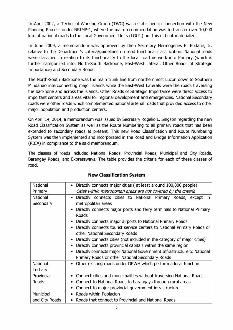
The classes of roads included National Roads, Provincial Roads, Municipal and City Roads,
Barangay Roads, and Expressways. The table provides the criteria for each of these classes of
road.
New Classification System
National
Primary
• Directly connects major cities ( at least around 100,000 people)
Cities within metropolitan areas are not covered by the criteria
National
Secondary
• Directly connects cities to National Primary Roads, except in
metropolitan areas
• Directly connects major ports and ferry terminals to National Primary
Roads
• Directly connects major airports to National Primary Roads
• Directly connects tourist service centers to National Primary Roads or
other National Secondary Roads
• Directly connects cities (not included in the category of major cities)
• Directly connects provincial capitals within the same region
• Directly connects major National Government Infrastructure to National
Primary Roads or other National Secondary Roads
National
Tertiary
• Other existing roads under DPWH which perform a local function
Provincial
Roads
• Connect cities and municipalities without traversing National Roads
• Connect to National Roads to barangays through rural areas
• Connect to major provincial government infrastructure
Municipal
and City Roads
• Roads within Poblacion
• Roads that connect to Provincial and National Roads

3
• Roads that provide inter-barangay connections to major Municipal and
City Infrastructure without traversing Provincial Roads
Barangay Roads • Other Public Roads (officially turned over) within the barangay and not
covered in the above definitions
Expressways • Highways with limited access, normally with interchanges; may include
facilities for levying tolls for passage in an open or closed system.
Modifications have been made to the new classification with the inclusion of the “National
Tertiary” class, instead of transferring 10,000 km. of National Roads to the Local Government
(city and municipality). No route numbers were assigned to Tertiary Roads as they function as
local road.
III. Route Numbering System
Along with a new Functional Classification, a Route Numbering system was created which can
be easily understood by road users. Route Numbering is essential to road users in planning their
itinerary. Road users will also expect that all roads of a certain classification, and of a certain
numbering scheme, will have similar performance standards. A well-numbered, well-signed and
well-publicized route system is also useful for road agencies and other government bodies to
channel traffic into preferred routes or corridors.
The DPWH web link of the details of the road classification and numbering can be viewed at:
http://dpwh.maps.arcgis.com/apps/OnePane/basicviewer/index.html?appid=4b48284a409844f
ab6876aa77be8bf58 which shall also be the official source of this information.
The Route Numbering system has been devised for Expressways, Primary Roads and Secondary
Roads at present. It may be expanded to the Tertiary class at a later date.
Route Numbering System
Classification Numbering
National Primary Nos. N1 to N49 for the "main" routes or corridors, i.e.
those connecting 3 or more cities
Nos. N50 to N99 for other primary routes connecting
two cities
National Secondary Nos. 100 to 999
Expressways E1, E2, E3, etc
Expressways are prefixed by the letter “E” for Expressway, in order to differentiate these roads
in road user’s mind from other types of road. The letter “E” implies a different design and
standard of road, and indicates to the public that a toll may be required. Expressways are

4
numbered continuously. A new number is not given simply because a different concessionaire is
in charge.
Primary Roads are numbered differently according to whether they form “main” corridors, or
whether they only connect two cities. Numbers N1 to N49 are used for “main” routes or
corridors like those connecting three or more cities. While, numbers N50 o N99 are for other
primary routes connecting two cities. This is purely for convention but it helps to differentiate
the nature and function of highways.
Secondary Roads have been given 3-digit numbers. The following general principles or guidelines
have been applied: (1) the first digit of the Secondary Route corresponds to the number of the
Primary Road to which it connects, if any. Thus, for example, Secondary Road 102 connects to
Primary Road 1 while Secondary Road 405 connects to Primary Road 4; (2) if a Secondary Route
connects two Primary Routes, then the first digit of the Secondary Route corresponds to the first
digit of the lowest numbered Primary Route. Thus, if a Secondary Route connects Primary Routes
3 and 4, then the first digit of the Secondary Route would be 3; (3) “Major” Secondary such as
those which can easily be identified as more significant thoroughfares have been numbered in
multiples of 10 (e.g. 410, 420, 430…); (4) Where possible, gaps have been left in the numbering
scheme to accommodate future expansion. Thus, there may be a Route 410, 411, 412 and then
the next Route may be 420, leaving a gap 413-419 for future use; (5) Most islands (apart from
the larger islands of Luzon and Mindanao) have unique first and second digits. Thus, for example,
Secondary roads in Bohol are numbered in the 85 series (i.e. 850, 851, 852, etc.) while Secondary
roads in Siquijor are numbered in the 86 series (i.e 860, 861, etc.) Note that, at this point, it has
not been possible to apply these guidelines strictly in certain cases especially in dense parts of
the network such as in National Capital Region.
It will be necessary to add new Routes in the future. Any change in classification of an individual
road section should result in a new Route Number. It will also be necessary to assign route
numbers to new roads, especially at the Primary and Secondary levels.
It is not possible to develop detailed procedures in numbering routes since each situation must
be dealt with on a case-by-case basis. The current Route Numbers will evolve over time as
network develops. Reviews shall be undertaken on a periodic six-year cycle and must be done
on a holistic basis and should consider the road network in its entirety rather than in a disjointed
manner.
IV. ROAD CONVERSION (2009-2015)
The initial classification system of roads in the Philippines was established by succession of laws
based from the necessity during the period of their implementation. There are several Executive
Orders (E.O.s) and Republic Acts (R.A) that governed the classification of roads in the Philippines.
E.O. No. 124, series of 1987, reorganizing the Department of Public Works and Highways, state
among others, “the Minister (now Secretary) of the Ministry (now Department) of Public
Works and Highways shall have the power to classify roads and highways into
national, regional (interpreted as routes of primary arterial roads), provincial, city,
municipal, and barangay roads and highways, based on objective criteria it shall

5
adopt; provide or authorize the conversion of roads and highways from one category
to another.”
Road conversion relates to funding or ownership of the road, which organization is responsible
for managing and maintaining an individual road. Normally, national roads are managed by the
National Government and local (Provincial, City, and Municipal) roads are managed by Local
Government.
A memorandum dated June 10, 2009 adopting the DPWH Road Functional Classification Criteria
and Technical Requirement was approved and signed by the Department Secretary with the
Planning Service as the final recommending arm of the Department and shall inspect and
evaluate the conversion of roads from one category to another.
There are three (3) ways of converting roads: the Executive, Legislative and Administrative
procedures. The Department of Public Works and Highways was mandated through E.O. No.
124, series of 1987 to convert regional highways, provincial, city, municipal, barangay roads into
national roads under its established Road Functional Classification Criteria and Technical
standards and requirements. For Legislative Procedure the Planning Service (PS) provides only
comment and information in consonance to the Department’s Criteria on Road Functional
Classification when requested by both Committees on Public Works, House of Representatives
and the Senate. During the hearings conducted by these committees, the Director and staff from
PS usually represent DPWH, if the Secretary is not available.
The local road proposed for conversion will be considered into national road by way of DPWH
Administrative Procedure, as mandated under E.O. No. 124, Series of 1987. Said road should
satisfy at least one of the new DPWH road functional classification criteria and should conform
to the technical requirements and standards for a national road; if these conditions are satisfied,
a Department Order (DO) will be issued by the DPWH Secretary converting the road.” The
Secretary of Public Works and Highways was given the authority to recommend roads to be
declared as national roads by the President of the Republic of the Philippines.
DPWH Requirements and Standards for a National Road:
1) Endorsement from the local government concerned;
2) Proof of acquisition of required road right-of-way; and
3) The road should have at least 6-meter carriageway width, in at least gravel surfacing and
in maintainable condition.
Since the Philippine road network is already mature, it is likely that there are very few cases
which can actually warrant a change in classification from local to national function.

6
COMPARATIVE NUMBER AND LENGTH OF CONVERTED ROADS FOR
CY 2009 – 2015
YEAR UNIT TOTAL RA DO RA/DO
2009 No. of road sections 27 11 15 1
Length (km) 499.62 300.16 194.64 4.82
2010 No. of road sections 45 40 4 1
Length (km) 356.87 207.99 122.40 26.48
2011 No. of road sections 9 0 9 0
Length (km) 62.64 0 62.64 0
2012 No. of road sections 9 0 9 0
Length (km) 60.79 0 60.79 0
2013 No. of road sections 64 37 27 0
Length (km) 541.04 435.77 105.27 0
2014 No. of road sections 24 0 24 0
Length (km) 118.01 0 118.01 0
2015 No. of road sections 7 0 7 0
Length (km) 52.65 0 52.65 0
Grand
Total
No. of road sections 185 88 95 2
Length (km) 1,680.55 943.92 705.33 31.30
The table shows the number and length of converted roads through Legislative and
Administrative procedures from 2009 to 2015.
Twenty-seven (27) local road sections with a validated length of 499.62 km were converted
in 2009. Eleven (11) road sections were converted through legislation and, fifteen (15) road
sections through Administrative Procedure and one (1) road section using both procedures.
In 2010, forty-five (45) local road sections were converted into national roads. Four (4) of
these road sections were converted through Administrative Procedure, forty (40) road sections
were converted through legislation and one (1) road section by both procedures.
In 2011 and 2012, there were no converted roads through Legislative Procedure, while
eighteen (18) local road sections were converted through Administrative Procedure. Majority
of the local roads requested for conversion did not satisfy at least one of the established
DPWH Road Functional Classification Criteria for a national road hence the number and length
of converted roads for this period are fewer as compared to the previous years.
For the year 2013, sixty-four (64) local road sections with an overall length of 541.04 km were
converted. Thirty seven (37) road sections with a length of 435.77 km were converted through
legislation and the rest, with a total length of 105.27 km were through Administrative
Procedure. This year has marked the most number of road sections that were converted due
to the upsurge in the number of requests that have passed the Functional Criteria set by the
Department.

7
In 2014, twenty-four (24) road sections having a total road length of 118.01 km were
converted through Administrative Procedure, bringing the overall total length from 2009 to
2014 to 1,638.97 km for the 178 road sections that were converted for the period
mentioned. All road sections converted from the year 2009 to 2014 were already included in
the RBIA database.
A total of seven (7) road sections were converted through the Department’s Administrative
Procedure in 2015, with an aggregated length of 52.65 km. This is considerably the smallest
number of roads converted since the institution of EO No. 124 in 1987. This decline is mostly
due to the fact that there is little scope for converting any road to National status given that
all roads that perform national road network functions (i.e those of Primary or Secondary
classification) have already been demarcated as such under the Road Classification System.
The Department’s main focus at this point is on developing the Primary and Secondary roads
to serve national road network functions. There is no basis for converting roads that largely
perform local functions.
There has been a noticeable increase in the number of road sections that were converted
through Republic Acts from 2009 to 2010. The growth rate for the said period is at 263.64%.
However, it may also be noted that a significant decrease in the number of roads have been
converted through DOs for the same period. The rate of decrease is at -46.67%.
Data show that there was a remarkable increase in the number of road sections that were
converted through both procedures in 2013. However, it can be noted that there was a steady
decline in the succeeding years. From a total of sixty-four (64) in 2013, down to twenty-four
(24) in 2014 and the lowest of seven (7) in 2015. Accordingly, the Philippine road network is
already mature, it is likely that there are very few cases which can actually warrant a change
in classification from local to national function.
Presented are graphs showing the number and length of roads converted per year from CY
2009 - 2015.
499.62
356.87
62.64
60.79
541.04
118.01
52.65
0
100
200
300
400
500
600
Len
gth
of
Ro
ad
s
Year
Length of Converted Roads per Year
Length of Converted Roads (km)
2009 2010 2011 2012 2013 2014 2015

8
The chart below shows the annual percentage distribution of the number of roads converted
in a period of seven years, from 2009 to 2015. The highest percentage distribution of
converted roads is 35% which was in 2013, followed by 24% in 2010, 15% in 2009, 13% in
2014, 5% in 2011 and 2012 and the lowest is at 4% in 2015.
The next chart represents the percentage distribution of the length of converted roads from
2009-2015. In the period of seven years, 32% is the highest percentage for the year 2013,
seconded by 30% in 2009, followed by 21% in 2010, 7% in 2014 and 4% in 2011 and 2012.
For 2015, the percentage is at 3%.
15%
24%
5%
5%
35%
13%
4%
Pecentage of Number of Roads Converted
2009 2010 2011 2012 2013 2014 2015
27
45
9 9
64
24
7
0
10
20
30
40
50
60
70
No
. o
f R
oa
ds
Year
Number of Converted Roads per Year
No. of Converted Roads
2009 2010 2011 2012 2013 2014 2015

9
For a more detailed list of converted national roads for CY 2015, please refer to Table 1.0.
V. Analysis of Data
A. National Road Length per Functional Classification
The table provides a summary of the development of the Philippine National Road Network
from 2007-2015. It shows the length of roads in figures based on their purpose including the
total and the increase per year. With the inception of the new Functional Classification in April
30%
21%
4%4%
32%
7%
3%
Percentage Road Length of Converted Roads per Year
2009
2010
2011
2012
2013
2014
2015
Year
National
Primary
(km)
National
Secondary
(km)
National
Tertiary
(km)
Total
Annual
Increase
(km)
2007 15,588.88 13,780.82 - 29,369.70 161.44
2008 15,663.45 13,986.9 - 29,650.36 280.64
2009 15,730.56 14,167.53 - 29,898.09 247.73
2010 15,871.91 15,370.47 - 31,242.38 1,344.29
2011 15,986.72 15,372.4 - 31,359.12 116.73
2012 16,056.47 15,541.21 - 31,597.68 238.56
2013 16,078.72 16,148.22 - 32,226.93 629.25
2014 7,060.39 14,051.37 11,414.73 32,526.50 299.57
2015 7,066.74 14,118.49 11,448.14 32,633.37 106.87

10
2014, the length of national roads have been apportioned accordingly, hence, the inclusion of
National Tertiary Roads.
The graph above gives us a clear picture of the growth rate of roads for the same period. The
rates are 0.55%, 0.95%, 0.83%, 4.3%, 0.37%, 0.76%, 1.95%, 0.93% and 0.33% for 2007,
2008, 2009, 2010, 2011, 2012, 2013, 2014 and 2015, respectively. Road length has increased
gradually with a remarkable surge in the year 2010. The increase was attributed to the various
local roads converted into national roads, a total of forty (40) road sections through Republic
Acts and four (4) road sections through the issuance of Departments Orders, results on the
spot check conducted on newly rehabilitated roads, road realignment, change in congressional
and district boundaries. The gap portion from K1536 + 260 to K1610 + 264, integrated
through the provisions of DO No. 13 dated February 9, 2010 of the Kapalong-Talaingod-San
Fernando-Valencia Road, with a length of 73.65 km under the jurisdiction of the Bukidnon 1st
District Engineering Office, was the longest road section to be incorporated in the RBIA
database within the said year.
For the year 2011, the Philippines had a total national road network of 31,359.12 km, an
increase of 116.74 km from the previous year, which was the shortest length, added to the
national road network for the past six years. The slight increase was attributed to the fact
that no local roads were converted through Republic Act and only nine (9) road sections were
converted through the issuance of Department Orders. Other factors that caused the change
in road length were the integration of gap portions, results of spot checks on newly
rehabilitated road sections, merging of road sections and the downgrading of existing national
road into a local road. The Balanga Capitol Road with a length of 1.35 km was downgraded
into a city road through the issuance of DO No. 44 dated August 10, 2011.
While in 2012, the national road network increased by 238.56 km with a total length of
31,597.68 km for that year. The increase was brought about by the conversion of local roads
into national roads, inclusion of newly improved gap sections, completed flyover and Y-length,
modified road configuration from single to dual carriageway. This year, five Department
Orders were issued reclassifying various local roads into national roads with a length of 60.79
0.55%0.95% 0.83%
4.3%0.37% 0.76%
1.95%0.93% 0.33%
27000
28000
29000
30000
31000
32000
33000
2007 2008 2009 2010 2011 2012 2013 2014 2015
Ro
ad
Le
ng
th
Year
Growth Rate of National Road Length(2007-2015)

11
km. On the other hand, thirteen road sections with a total length of 32.66 km were temporarily
deleted from the List of National Roads since they no longer function as to their
purpose. These roads were either impassable due to road cut, collapsed bridges or were
transferred to ARMM jurisdiction.
For the year 2013, the country had a national road length of 32,226.93 km which reflects an
increase of 629.25 km. There was an increase of 22.25 km for National Primary Roads and
607.01 km for National Secondary Roads. The significant increase in the length of secondary
roads was brought about by the conversion of local roads into national roads and the
integration of the newly improved gap portion of the existing national roads.
In 2014, there was an increase of 299.57 km in the total road network which indicates a
growth rate of 0.93% from the previous year. Whereas, there has been a 0.33% growth rate
in the succeeding year at 106.87 km. The increase is due to newly improved gap sections,
road sections that were subjected to validation, road inventory, and road conversion.
The year 2007 has registered a total national road length of 29,369.70 km, while the year
2015 posted 32,633.37 km, recording an increase of 11.11% in nine (9) years. As of
November 2015, Region VIII has the longest length of national road with a total length of
2,529.80 km, while NCR has a total road length of 1,150.07 km which has the shortest length
of national roads within the regions in the Philippines.
B. COMPARATIVE REGIONAL YEARLY LENGTH OF NATIONAL ROADS (2007-2015)
The data illustrated in Table 1.2 show the increase or decrease of road length according to
surface type (paved or unpaved) and functional classification in every region nationwide.
These data give us a clear idea on the state of national roads in the country from 2007 to
2015. It provides information that can be used as a gauge in monitoring the progress of road
surface on an annual basis, so as to assess and compare existing and previous road lengths
which are utilized in effective planning and programming of road networks in the Philippines.
These data are very useful information to give support to decision makers from the
government and private sector on the future plans and programs in their area of concern to
spur economic development in accordance with national goals and objectives.
The trend shows that from year 2007 to 2015, there was a relative decrease in the length of
unpaved roads and consequently an increase in the length of paved roads all throughout the
regions in the country. This was due to road improvements that can be attributed to newly
improved gap sections, road sections that were subjected to validation and road inventory
and roads requested for conversion from local road to national road by different proponents
through Republic Act or a Department Order evaluated by the Department in its commitment
to provide total connectivity of national roads.
A remarkable increase in road length was recorded in 2010 in Region VII with an increase of
215.16 km. However, it can be observed that there was a considerable decrease in road length
in Region IV-A in 2008. On the other hand, this has a negligible effect on the overall road

12
length of the country as there was still an increment of 280.65 km for that year despite the
noted decrease in road length.
As a result of the inclusion of tertiary roads to the national road network, through the
memorandum that was signed by the Secretary in 2014, there has been a notable decrease
in the length of Primary and Secondary roads. Nevertheless, this inclusion has not affected
the aggregate length of national roads since roads tagged as tertiary were merely reclassified
and remain part of the road network.
C. Length of Road and Percentage per Surface Type
The country’s national road network is predominantly concrete surfacing at 58.72% or
19,162.72 km out of the total length of 32,633.37 km. Asphalt roads which comprised 29.90%
of the total road network also increased with a length of 9,756.45 km. Gravel and earth roads
are now 11.14% and 0.24% or 3,636.96 km and 77.24 km, respectively.
For the year 2015, Region VIII has the longest concrete roads among the regions in the
country, with a length of 1,774.19 km, while NCR has the shortest at 418 km.
58.72%29.90%
11.14% 0.24%
Surface Type
Concrete Asphalt Gravel Earth
Surface Type Length (km) Percentage
Concrete 19,162.72 58.72%
Asphalt 9,756.45 29.90%
Gravel 3,636.96 11.14%
Earth 77.24 0.24%
Total 32,633.37 100.00%

13
D. Length and Percentage of Paved & Unpaved Roads from 2007-2015
Year PAVED UNPAVED
Total Total % Total %
2007 21,006.35 71.52 8,363.35 28.48 29,369.70
2008 21,676.53 73.11 7,973.83 26.89 29,650.36
2009 22,468.67 75.15 7,429.42 24.85 29,898.09
2010 24,126.56 77.22 7,115.82 22.78 31,242.38
2011 24,834.38 79.19 6,524.74 20.81 31,359.12
2012 25,443.44 80.52 6,154.24 19.48 31,597.68
2013 26,772.93 83.08 5,454 16.92 32,226.93
2014 27,816.46 85.52 4,710.04 14.48 32,526.50
2015 28,919.17 88.62 3,714.20 11.38 32,633.37
Length and Growth Rate of Paved Roads from 2007-2015
Paved roads in the Philippines steadily increased in the past nine (9) years. The table and
graph show the growth of paved roads in the Philippine national road network from 2007-
2015. The paved roads from the given period have an annual growth rate of 3.19%, 3.65%,
7.38%, 2.93%, 2.45%, 5.23%, 3.90% and 3.96% respectively.
The Department has aimed at paving 100% or 31,242 km of the national road network in
2016 from a baseline of 80.9% in 2010 or 25,281 km of paved roads. Through implementation
of right projects, the target outcome has already accomplished 88.62% or 28,919.17 km of
paved roads with the present (2015) road network of 32,633.37 km.
Year Length (km) Growth Rate
2007 21,006.35
2008 21,676.53 3.19%
2009 22,468.67 3.65%
2010 24,126.56 7.38%
2011 24,834.38 2.93%
2012 25,443.44 2.45%
2013 26,772.93 5.23%
2014 27,816.46 3.90%
2015 28,919.17 3.96%

14
The graph (length of paved and unpaved roads) shows a noticeable increase in paved roads
and decrease in unpaved roads in the country. The line graph shows the yearly increase of
paved road and the yearly decrease of unpaved roads from 2007 to 2015. For the past nine
(9) years, there has been an increase of 7,912.82 km of paved roads in the Philippines and
consequently, a decrease by 4,649.15 km of unpaved roads. For the year 2015, out of
32,633.37 km of total of national roads, 88.62% is paved and 11.38% is still unpaved.
Based on the total national road network, National Capital Region (NCR) has reached the
maximum target of 100% with an aggregate length of 1,1150.07 km which is the highest
among the seventeen (17) regions that are under the management and supervision of the
Department. Conversely, Cordillera Autonomous Region (CAR) has the lowest percentage of
paved roads at 70.90% with a total length of 1,521.39 km.
Among the three (3) major island groups, Mindanao has the smallest percentage of paved
roads. However, this situation is currently being addressed through various projects that are
being undertaken by DPWH. In Cagayan de Oro City alone, the 2015 budget allocation includes
8,363.35
7,973.83
7,429.42
7,115.82
6,524.74
6,154.24
5,454
4,710.04
3,714.20
21,006.35
21,676.53
22,468.67
24,126.56
24,834.38
25,443.44
26,772.93
27,816.46
28,919.17
0.00
5,000.00
10,000.00
15,000.00
20,000.00
25,000.00
30,000.00
35,000.00
2007 2008 2009 2010 2011 2012 2013 2014 2015
Len
gth
(k
m)
Length of Paved and Unpaved Roads
(2007-2015)
Unpaved Paved
100
92.00
70.90
97.78
92.16
96.5195.80
79.51
92.93
97.1697.67
96.33
73.16
80.07 80.49 79.4482.98
0
20
40
60
80
100
120
NCR NIR CAR I II III IV-A IV-B V VI VII VIII IX X XI XII XIII
Percentage of Paved Roads per Region

15
24 road concreting/rehabilitation projects, 14 building projects, eight (8) flood control and
drainage projects, six (6) road widening projects, four (4) improvement of off-carriageway
projects, four (4) bridge projects, two (2) coastal road projects, one (1) diversion road project,
and one (1) bypass road project. Add to that the P230 million worth of road upgrading project
currently implemented by the DPWH Regional Office XII at Magpet, North Cotabato wherein
two (2) road projects along Magpet- Nowa- Doruluman – Greenfield Road will actualize the
paving of a total of 10.798 kilometers of gravelled national secondary road. One is the
upgrading of the 3.68km road in Barangay Basak and another in Barangay Badiangon paving
a 7.16km road. These are just some of the many measures that the Department is undertaking
to ensure that its goal of increased mobility and total connectivity is realized.
E. Road Condition
The graph provides a comparison of the assessed road condition of the country in 2014 as
that of 2015. The Visual Road Condition (RoCond) survey is a yearly activity wherein the
condition of the road is being assessed manually. The gathered data is being utilized as one
of the components in running the HDM-4 analysis and for prioritization of projects. Assessors
must have to hike the stretch of roads in order to visualize all the defects and come-up with
an accurate assessment to maintain the sustainability and viability of the collected data. The
road condition is assessed as “Good”, “Fair”, “Poor” or “Bad”. Good and fair road conditions
are subjected to routine maintenance while poor conditions are due for rehabilitation and
those with bad conditions are recommended for total reconstruction. However, there are
some road sections that were not assessed due to the following factors: these roads are either
under construction, committed for construction and bridges and/or segments with lengths
below the 50-meter gauging length.
For the year 2015, record shows that out of the 32,633.37 km total length of national road,
35.16 % is in good condition, 32.12 % in fair condition, 16.00 % in poor condition, 7.56% in
bad condition while 9.17 % of the total road network were not assessed.
33.99%
31.46%
17.11%
9.31%8.13%
35.16%32.12%
16.00%
7.56% 9.17%
0.00%
5.00%
10.00%
15.00%
20.00%
25.00%
30.00%
35.00%
40.00%
Good Fair Poor Bad No Assessment
Road Condition 2014-2015
2014 2015

16
As shown in the chart, for the year 2015, the percentage of good and fair condition at 38.72%
and 32.91% of paved roads are higher as compared to the percentage inclusive of unpaved
roads at 35.16% and 32.12%, respectively. Whereas, poor condition of the whole national
road network at 16.00% is higher than that of paved roads at 15.03%. While, the bad
condition for paved roads is 7.15% which is slightly lower than the whole network at 7.56%.
(Please refer to the graph found in page 13 for details.)
The following Visual Condition Index (VCI) value determines the condition of the segment
assessed:
ROAD
CONDITION
CONDITION
RATING
>70 - 100 Good
>40 - 70 Fair
>20 - 40 Poor
1 – 20 Bad
F. International Roughness Index (IRI)
Roughness data is one of the key parameters for the operation of the Pavement Management
System (PMS) using the HDM-4 software. PMS is used for long-term, medium-term and annual
planning and programming purposes. Likewise, information on roughness is a vital data set
in reporting network performance under the Department’s Performance Governance System
(PGS), which is aligned with the administration’s initiative of coming up with strategic and
performance management tools that would allow government agencies to be assessed
objectively, in order to foster transparency and accountability in the different tiers of the
organization.
38.7%
32.9%
15.03%
7.15%
6.19%
2015 Road Condition of Paved Roads
Good Fair Poor Bad No Assessment

17
Reduced roughness is a key driver of economic benefit and therefore is crucial to the operation
of the PMS. In order to address this matter, a nationwide roughness survey of the paved road
network was outsourced under the World Bank funded G-02 project, conducted in two (2)
different phases, original contract and supplemental contract, from 22 June 2012 to 02
February 2014. The aforementioned contracts contained 12,201 km and 7,612 km of network,
respectively; which is 19,813 km in total, in addition to around 6,000 km of paved roads that
have undergone roughness survey through the International Road Assessment Program
(iRAP) Phase 1 and 2 undertaken with other partner agencies, to assess road safety in the
Philippines; for a grand total of 25,812 km of IRI data of paved roads.
Under the National Road Roughness Index Program (NRRIP), which was authorized to
commence on 03 June 2015, and will be conducted on a three (3) yearly cycle, national paved
roads will be surveyed to facilitate the planning process and monitor network performance in
accordance with the PGS on the most important roads. The Department shall focus on the
roughness data on Primary and Secondary roads only, not on Tertiary; for 7,049 km and 6,933
km of the aforementioned roads, respectively with an aggregate length of 13,982 km.
As shown in the chart, out of the national roads with roughness data; 25% is in good condition,
31% in fair condition, 30% in poor condition, and 14% is in bad condition. Segments of the
roads with an average IRI of 1-3 are in “good” condition, >3-5 in “fair” condition, >5-7 in
“poor” condition and >7 in “bad” condition.
25.16%
30.56% 29.99%
14.29%
0.00
5.00
10.00
15.00
20.00
25.00
30.00
35.00
Good Fair Poor Bad
Percentage of 2015 International Roughness Index (IRI)
on Paved Roads

18
Shown in the graph is the summary of Average IRI per Region. It shows that Region VIII has
the smoothest road surface, having an average IRI of 3.48. Out of the 558.85 km of surveyed
roads in the said region, 37% are in Good condition, 31% are in Fair condition, 22% are in
Poor condition and 10% in Bad condition. This can be attributed to the number of newly
constructed roads in the region. On the other hand, CAR registered the poorest average
condition, having an IRI of 6.88. Out of the 940.61 km of surveyed paved roads, 2% are in
Good condition, 10% are in Fair condition, 42% fall under the category of Poor and 45% are
in Bad condition. The unsatisfactory roughness condition of the roads in CAR is attributed to
its mountainous terrains that are prone to landslides and soil erosions. It is also difficult to
control the surface runoff during rains which cause road damages.
G. Road Density
A well-developed road transport sector, most especially in developing countries, is assumed
to fuel up the growth process through a variety of activities of the development endeavors of
a nation. Among these, creation of market access opportunities for agricultural products is
the most crucial.
Road transport facilities play a significant role in both the production and consumption
decisions of every household in their day-to-day activities. Besides, road transport facilities
are essential for expanding education, health service provision, trade furtherance – both within
the country and the export market, and better public as well as private service provisions,
including banking and insurance services, to the poor and marginalized rural dweller. Likewise,
roads serve as key infrastructural units, which provide linkages to other modes of
transportation like railways, shipping, and air network. Hence, it is imperative that we consider
all the factors necessary in coming up with the optimum plan to improve road infrastructure,
one of which is road density.
Road density pertains to the ratio of the length of the country's total road network to the
country's land area. The road network includes all roads in the country: motorways, highways,
6.88
4.69
4.93
4.10
4.88
3.92
4.11
5.30
4.22
5.22
4.23
3.48
4.16
4.90
4.23
4.36
4.94
0.00
1.00
2.00
3.00
4.00
5.00
6.00
7.00
8.00
CAR NCR NIR I II III IV-A IV-B V VI VII VIII IX X XI XII XIII
Average International Roughness Index (IRI) per Region

19
main or national roads, secondary or regional roads, and other urban and rural roads. It is
considered as an appropriate index of human activity and land-use intensity.
The table above provides a rundown of the road density of the country in the regional and national
level for the year 2004-2015. It encompasses the national primary, secondary and tertiary roads;
with the exclusion, however, of local roads.
There is an evident steady increase in road density in the past ten-year period, beginning 2006
to the current year. However, there is a noticeable decrease from 2004 to 2005 due to the
implementation of the RBIA wherein all national roads were subjected to centerline survey using
Global Positioning System (GPS). Portions of the road that were found to be inaccessible and/or
abandoned were excluded in the list.
In terms of road density, for the current year, the National Capital Region (NCR) has 185.63
kilometers of roads per square kilometer of land area whereas Central Visayas, the region with
the second highest road density, has only 16.62 kilometers per square kilometer. Cagayan Valley
has the lowest road density per square kilometer at 6.40. Higher income local government units
are better able to provide the road network needed in the local areas. Overall, the Philippines’
road density is 10.49 kilometers per square kilometers.