Embed Size (px)
Citation preview

2016 UNDERWATER
BRIDGE INSPECTION REPORT
BRIDGE #
DISTRICT: COUNTY: CITY/TOWNSHIP:
Date of Inspection:
Equipment Used:
Inspected By:
Report Written By:
Report Reviewed By:
Final Report Date:
57518
CSAH 3 over RED LAKE RIVER
District 2 Pennington DEER PARK
09/27/2016
Schroeder, Brian
Brian Schroeder
County Highway AgencyOwner:
MinnesotaSTATE:

UNDERWATER SUMMARY 3
UNDERWATER INSPECTION 4
UNDERWATER INSPECTION PROCEDURES 6
STRUCTURE INVENTORY 7
ELEMENTS 8
PICTURES 11
DRAWINGS 17
TABLE OF CONTENTS
PAGE NUMBER

Contractor:
Reinspect the submerged substructure units at the normal maximum recommended (NBIS) interval of sixty (60) months.
Ayres Associates & Collins Engineers, Inc.
9687Contractor Job Number:
RECOMMENDATIONS
REPORT SUMMARY
UNDERWATER INSPECTION
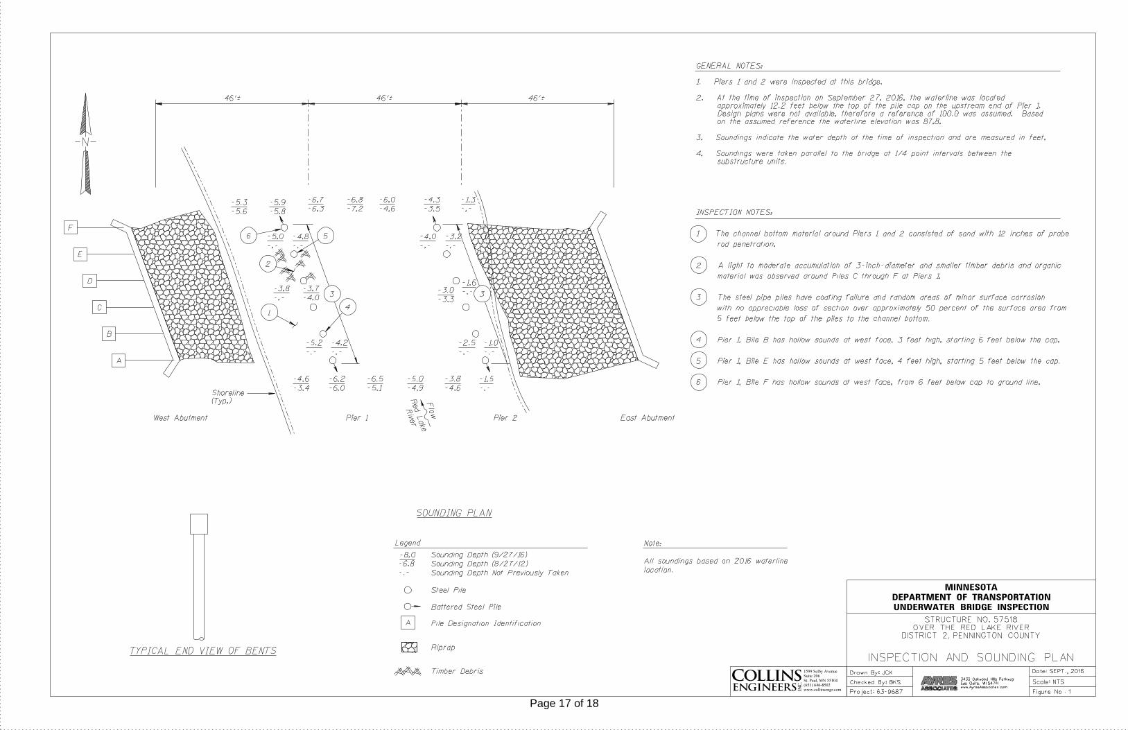
The substructure units inspected at Bridge No. 57518, Piers 1 and 2, were found to be in good condition with no defects of structural significance observed. The channel bottom consisted of sand which was well established and appeared stable with no evidence of scour.
(A) The 16 inch diameter pile encasements of Piers 1 and 2 were coated from top of pile to the channel bottom. The piles typically have no loss of coating from top of piles down 5 feet. From 5 feet below the top of the pile to the channel bottom, the piles have loss of coating over up to 50% of total surface area. In the areas of coating loss, the piles have random areas of minor surface corrosion with no appreciable section loss.(B) Pier 1, Pile B (second pile from the south) has hollow sounds at west face, 3 feet high, starting 6 feet below cap.(C) Pier 1, Pile E (second pile from the north) has hollow sounds at west face, 4 feet high, starting 5 feet below cap.(D) Pier 1, Pile F (northern most pile) has hollow sounds at west face, from 6 feet below cap to ground line.(E) Light to moderate accumulations of timber debris and organic material were observed around Piles C through F of Pier 1.
INSPECTION FINDINGS
Page 3 of 18

The top of the pile cap on the south side of Pier 1Water Level Reference:
WATERLINE DATUM
Waterline Elevation (feet):
The waterline was approximately 12.2 feet below reference.Description:
87.8
4.
Piers 1 and 2Substructure(s) Inspected:
SUBSTRUCTURE INSPECTION DATA
General Shape:
6.2Maximum Water Depth at Substructure(s) Inspected (feet):
The piers each consist of a single row of six concrete filled steel pipe piles. The piles at each end are battered in the direction parallel to the pier. The piles support a rectangular reinforced concrete pile cap with rounded ends.
Code:Item 62: Culvert:
7
Y 48 09/2016Code:Item 92B: Underwater Inspection:
Code:
(Minnesota specific codes are used for 92B and 113)
NBIS CODING INFORMATION5.
Item 60: Substructure:
Item 61: Channel and Channel Protection:
7Code:
District 2District:
CSAH 3
County:
The superstructure consists of three spans of multiple precast concrete beams supporting a reinforced concrete deck. The superstructure is supported by two reinforced concrete abutments and two concrete filled steel pipe pile piers. The piers are numbered 1 and 2 starting from the west end of the bridge. No design drawings were available.
Bridge Description:
057 - Pennington
Facility Carried:
BRIDGE DATA1.
UNDERWATER INSPECTION
Bridge #:
RED LAKE RIVERFeature Intersected:
57518
Underwater Visibility (feet):
Cloudy, 46°FWeather Conditions:
4.0
3.
1.0Waterway Velocity (ft/sec):
09/27/2016
Professional Engineer/Team Leader:
INSPECTION DATA2.
Brian K. Schroeder, P.E.
Date of Underwater Inspection:
Brian K. Schroeder, P.E.Inspection Diver:
Page 4 of 18

885 Scour 1 EA 1
STRUCTURAL ELEMENT CONDITION RATING
Conditions
6.
I
Bridge is scour critical because abutment or pier foundation is rated as unstable due to observed scour at bridge site.
Item 113: Scour Critical Bridge: Code:
No (Mark your selection with an X)Yes X
225
CS3 CS4
Steel Piles 9 312 EA
CS2ELEM # Unit CS1Element Description Quantity
Page 5 of 18

The routine underwater inspection of Bridge 57518 (CSAH No. 3 over the Red Lake River) was completed on September 27, 2016. The underwater inspection was conducted from shore. The inspection was conducted by a team consisting of a PE-Diver with a valid MnDOT Team leader certification, a backup diver and a dive tender. The inspection utilized commercial dive equipment and techniques (SSA and/or SCUBA) in accordance with OSHA regulations. Profiles were taken along the upstream and downstream faces of the bridge and around the periphery of substructure units to determine the presence, location and area of scour.
The bridge elements inspected consisted of two piers each consisting of a single row of six concrete filled steel pipe piles. According to the bridge inventory or design drawings, the piles support a rectangular reinforced concrete pile cap with rounded ends. Inspection procedures followed FHWA guidance and the MnDOT Bridge and Structure Inspection Program Manual with channel bottom probing to search for foundations. The routine underwater inspection frequency is recommended to remain at 60 months based on those findings and risk factors. Also, inspection procedures should continue to follow the above approach and standard guidance with 100% Level I and 10% Level II intensity efforts.
INSPECTION PROCEDURES
UNDERWATER INSPECTION
Page 6 of 18

Spec. Feat.Pier Foundation (Material/Type)
3 - STEELCantilever ID
+ W A T E R W A Y +Number of Spans Historic Status
4 - PILE BENT
Underwater 60Culvert Type 3 - FTG PILE
Pinned Asbly.
09/27/2016
Barrel Length
139.1 ft. Navigation Control
Waterway Opening (sf.) 1105Structure Length
ft. Year Painted
0 - No nav. control on waterwayDeck Width (Out-to-Out) 44.0
+ P A I N T +
APPR: 0 TOTAL:5 - Not eligible
MAIN: 3
Main Span Length 46.3 ft.Drainage Area (sq. mi.) 2289.0
B R I D G E D A T A +Main Span Detail
N - NOT REQUIRED+ M I S C.
Appr. Span Type Structure Flared
GR Termini N - NOT REQUIRED
Appr. Guardrail
Main Span Type 5 - Prestress or Precast Median Width On Bridge
ft. Bridge Railing 1 - MEETS STANDARDS
N - NOT REQUIRED
Main Span Design 20 - Double Tee
ft. GR Transition
Skew 20 LEFT
Y/N Freq Date
Abutment Foundation (Material/Type)
1 - CONC Frac. Critical
D E P T H I N S P. +Appr. Span Design
0 - No flare+ I N
Appr. Span Detail Field Conn. ID
Parallel Structure N - No parallel structure
Pier Protection
0 - Not Required
Rating Date 10/17/20135651 sq. ft. Traffic
ft. 50B. Rt 0.00Sidewalk Width 50A. Lt 0.00
Roadway Area (Curb-to-Curb)
Posted Load 0 - Not Required
PostingStructure Area (Out-to-Out) 6120 sq. ft.
DBL:VEH: SEMI:
Rt 22 ARail Type Lt 22 C N - N/AN - N/A B N - N/A
N - Not Applicable Overweight Permit CodesCurb Height Lt
ft. Horizontal 0 - Not Required
0.00 ft. Vertical0.00 ft. Rt
Wear Surf Install Year
sq. ft. Nav. Vert. Lift Bridge Clear. (ft.)
I - LOW RISK YearPrimer Type MN Scour Code
Painted Area
Unsound Paint % Nav. Clr. (ft.)Deck Material 1 - Concrete Cast-in-Place 0.0Wear Surf Type 6 - Bituminous
Vert. 0.0 Horiz.
S I G N S +Operating Rating 2 - HS TRUCK
0 - None + B R I D G E
Inventory Rating 2 - HS TRUCK 20.8
34.8Deck Rebars Install Year
Deck Rebars
Finish TypeWear Course/Fill Depth 0.33 ft.
0 - None
Design Load 9 - HS 25 (OR GREATER)
+ C A P A C I T Y R A T I N G S +Deck Membrane
48 ° 1
Inspector Name Schroeder, Brian
Latitude Control Section (TH Only) Status' 12.98 ''
2 - 2-way traffic
Routine Inspection Frequency 24
Sect., Twp., Range
0.1 MI E OF JCT CSAH 25 Level of Service 1 - MAINLINE
- 40W Roadway Type3 - 152N
Detour Length 6.0 mi.R A T I N G S +
Custodian 02 - County Highway Agency
Owner 02 - County Highway AgencyDeck 8 Unsound
Deck %
C O N D I T I O N° 46 '
A - Open
Longitude 95 033+00.200 + N B I 28.82 '' Reference Point
Crew
+ I N S P E C T I O N +
Agency Br. No. 97
District 02
Bridge Match ID (TIS) 0 Userkey
CSAH 3 over RED LAKE RIVER
Minnesota Structure Inventory Report
Bridge ID: 57518
+ G E N E R A L + + R O A D W A Y +
Date: 01/30/2017
Sufficiency Rating 99.8Roadway Name or Description
3
City
Routine Inspection Date 10/18/2016
Desc. Loc.
Township 57004 - DEER PARK CSAH 3
Number
NRoadway O/U Key Route On StructureMaint. Area Structurally Deficient
NRoute Sys 04 - CSAHCounty 057 - Pennington Functionally Obsolete
Lanes
Waterway Adequacy 8Max. Vert. Clear.
ft.Legislative District 02Bft.Potential ABC 2 - N/A ft.
ft.On - Off System Roadway Width 40.60 ft.
Vertical Clearance ft.1 - ON
Underclearances N
Service On 1 - Highway Appr. Surface Width+ S A F E T Y F E A T U R E S +
5 - Waterway Bridge Roadway Width 40.6
36.0 ft.
Service Under
ft.
ft. Approach Alignment 8Horizontal Clear.
ft.
ft.+ S T R U C T U R E + Lateral Clearance
HCADT ADTT7
Year Built 1996
MN Year Reconstructed Functional Class
%Channel 7
Substructure
0Superstructure 8
ON 2 UNDER
420 YEAR 2008BMU Agreement ADT
Structure Evaluation 7If Divided
D I M E N S I O N S +Bridge Plan Location 3 - COUNTY
Deck Geometry 9NB-EB SB-WBDate Opened to Traffic
+ R D W Y
FHWA Year Reconstructed
MN Temporary Status
07 - Rural - Major CollectorCulvert N
A P P R A I S A L R A T I N G S ++ N B I
Page 7 of 18

County:
City:
Township:
Township:Section: Range:
Span Type:
NBI Deck: Super: Sub: Chan: Culv:
Appraisal Ratings - Approach: Waterway:
Required Bridge Signs - Load Posting:
Horizntal:
Traffic:
Vertical:
MN Scour Code:
Open, Posted, Closed:
Location:
Route:
Control Section:
Local Agency Bridge Nbr.:
Ref. Pt.:
Maint. Area:
Length:
Deck Width:
Rdwy. Area/ Pct. Unsnd:
Paint Area/ Pct. Unsnd:
Culvert:
Pennington
57004 - DEER PARK
152N3 40W
5 - Prestressed Concrete 2 -Stringer/Multi-beam or Girder
8 8 7 7 N
8 8
0 - Not Required
0 - Not Required
0 - Not Required
N - Not Applicable
I - LOW RISK
0.1 MI E OF JCT CSAH 25
04 - CSAH 3 033+00.200
139.1
44.0
5651 sq. ft. / %
sq. ft. / %
N/A
A - Open
ft.
ft.
Postings:List:
MINNESOTA BRIDGE INSPECTION REPORT
02/06/2017
BRIDGE 57518 CSAH 3 OVER RED LAKE RIVER
Unofficial Structurally Deficient N
NUnofficial Functionally Obsolete
Unofficial Sufficiency Rating 99.8
ELEMNBR ELEMENT NAME INSP. DATE QUANTITY
QTYCS 1
QTYCS 2
QTYCS 3
QTYCS 4REPORT TYPE
Prestressed Concrete Top Flange 09/27/2016 6120 SF 6110 10 0 015 Underwater
10/18/2016 6120 SF 6110 10 0 0Routine
Notes: [2016] Migrator assumed CS1.
Underside of Concrete Deck Notes: Under deck: at span #1 by the abutment between beam#1 and #2 minor crack with light leaching withefflorescence. The same at span #3 by the abutment. No rust stains at this time. (2014)Span #1 joint between beam #1 and #2, and #4, #5 show leaching with efflorescence, and showing rust. The same at span #3, but no rust.(2016)
510 - Wearing Surfaces 5651 SF 4651 1000 0 0
Notes: Bituminous Overlay Notes: THE DECK WAS MILLED AND OVERLAY BIT. 2009, IN GOOD SHAPE. (2010) Minor cracking (2014)Minor cracking been sealed. (2016)
Underwater 09/27/2016
5651 SF 4651 1000 0 0Routine 10/18/2016
Prestressed Concrete OpenGirder/Beam
09/27/2016 1669 LF 1669 0 0 0109 Underwater
10/18/2016 1669 LF 1669 0 0 0Routine
Notes: [2016] Migrator estimated the quantity of the double tees. Verify the quantity by multiplying the number of vertical beams by the decklength.NO CHG. (2010)(2014) No chg. (2016)
Reinforced Concrete Abutment 09/27/2016 138 LF 137 1 0 0215 Underwater
10/18/2016 138 LF 137 1 0 0Routine
Notes: [2016] Migrator added 40 LF to abutment quantity to account for wing walls (CS1:40 CS2:0 CS3:0 CS4:0).SOME CONCRETE CHIPPING ALONG BRIDGE SEATS AT EAST ABUTMENT CONCRETE CHIPPING ISTHE SAME AS LAST INSPECTION. NO CHG. (2010) No CHG (2012)Minor vertical cracking at both abutments. (2012) West abutment about center crack has some leaching of efflorescence down at the slope.(2014)After NBIS Review: The west abutment show settlement of the slope. The county repaired it by hauling riprap and fill. Filling under theabutment. Fall of 2015
Wing wall notes: NE WING WALL - SPALLING AND DELAMINATION MINOR. (2010)NW WING WALL - APPEAR TO BE IN GENERALLY GOOD CONDITION (2010)SE WING WALL - APPEAR TO BE IN GENERALLY GOOD CONDITION (2010)SW WING WALL - APPEAR TO BE IN GENERALLY GOOD CONDITION (2010)No Change (2012) No Chg. (2014)East South wing wall show minor cracking. (2016)
The East abutment North end show moderate settlement of the
Page 8 of 18

Steel Pile 09/27/2016 12 EA 9 3 0 0225 Underwater
10/18/2016 12 EA 12 0 0 0Routine
Notes: PIER 2 - PILING 4 & 5, 5'" DOWN FROM CAP NEEDS PAINT. (2010) Fair condition (2016)[2016 UW]Pier 1, Pile B (second pile from the south) has hollow sounds at west face, 3 feet high, starting 6 feet below cap.Pier 1, Pile E (second pile from the north) has hollow sounds at west face, 4 feet high, starting 5 feet below cap.Pier 1, Pile F (northern most pile) has hollow sounds at west face, from 6 feet below cap to ground line.
515 - Steel Protective Coating 1277 SF 958 319 0 0
Notes: [2016] Migrator assumed quantity of 999 SF and estimated the condition states. Overall, the 16 inch diameter pile encasements of Piers1 and 2 were coated from top of pile to the channel bottom. The piles typically had no loss of coating from top of piles down 5 feet. From 5 feetbelow the top channel bottom, the piles had loss of coating over up to 25% of total surface area. In the areas of coating loss, the piles hadrandom areas of minor surface corrosion with no appreciable section loss.
Underwater 09/27/2016
1277 SF 958 319 0 0Routine 10/18/2016
Reinforced Concrete Pier Cap 09/27/2016 98 LF 98 0 0 0234 Underwater
10/18/2016 98 LF 98 0 0 0Routine
Notes: GOOD SHAPE (2010)(2014) No chg. (2016)
Reinforced Concrete Bridge Railing 09/27/2016 262 LF 262 0 0 0331 Underwater
10/18/2016 262 LF 262 0 0 0Routine
Notes: NO CHG. (2010) Shows minor cracking. (2014) No chg. (2016)
Critical Deficiencies or Safety Hazards 09/27/2016 1 EA 1 0 0 0800 Underwater
10/18/2016 1 EA 1 0 0 0Routine
Notes: NO CHG. (2010) (2014)
Bituminous Approach Roadway 09/27/2016 2 EA 0 2 0 0822 Underwater
10/18/2016 2 EA 0 2 0 0Routine
Notes: APPROACHES GOOD (2010) No Chg. (2014)Minor settling a both approaches. (2016)
Secondary Members (Superstructure) 09/27/2016 19 EA 19 0 0 0855 Underwater
10/18/2016 19 EA 19 0 0 0Routine
Notes: Good Condition (2016)
Scour 09/27/2016 1 EA 1 0 0 0885 Underwater
Other Bridge Signing 09/27/2016 1 EA 1 0 0 0891 Underwater
10/18/2016 1 EA 1 0 0 0Routine
Notes: END MARKERS IN GOOD CONDITION. (2010) (2014) No chg. (2016)
Slopes & Slope Protection 09/27/2016 1 EA 0 1 0 0892 Underwater
10/18/2016 1 EA 0 1 0 0Routine
Notes: MINOR TO MOD. SETTLING EAST SIDE. (2010)MOD. SETTLING WEST SIDE. (2010)No Change (2012) (2014)The East abutment North end show moderate settlement of the slope. In same area can see the bottom of the abutment but not under it.The West slope in good condition been fixed. (2016)
ELEMNBR ELEMENT NAME INSP. DATE QUANTITY
QTYCS 1
QTYCS 2
QTYCS 3
QTYCS 4
BRIDGE 57518 CSAH 3 OVER RED LAKE RIVER
REPORT TYPE
Page 9 of 18

Deck & Approach Drainage 09/27/2016 1 EA 0 1 0 0894 Underwater
10/18/2016 1 EA 0 1 0 0Routine
Notes: NE WING WALL LITTLE OR MOD. SETTLING. AROUND END MOD. (2010) No CHG (2012) (2014)SE WING WALL LITTLE OR NO SETTLING. (2010) No CHG (2012) (2014)SW WING WALL MOD. SETTLING AROUND END. (2010) No CHG (2012) (2014)NW WING WALL LITTLE OR NO SETTLING, END MOD. TO BAD HOLE. (2010) No CHG (2012)Deck needs cleaning gutter and drains. (2016)
Protected Species 09/27/2016 1 EA 0 1 0 0900 Underwater
10/18/2016 1 EA 0 1 0 0Routine
Notes: Use this element to track the presence of protected species living on this structure.Swallow nests are present on the structure. (2016)
General Notes:
Inspector's Signature Reviewer's Signature
10-29-04 NO CHANGES SINCE PREVIOUS INSPECTION. JJ 11-20-06 NO STRUCTURAL CHANGES SINCE LASTINSPECTION. JJ SEE ELEMENTS (2012) Added Underwater Bridge Inspection report, Aug 27,2012See Elements (2014)(2016) Elements 310, 313. from 2015 NBIS Compliance report for Pennington County (There are no visible bearings on thisbridge. Should delete elements 310 &313) JCM
58. Deck NBI:
36A. Brdg Railings NBI:
36B. Transitions NBI:
36C. Appr Guardrail NBI:
36D. Appr GuardrailTerminal NBI:
59. Superstructure NBI:
60. Substructure NBI:
61. Channel NBI:
62. Culvert NBI:
71. Waterway Adeq NBI:
72. Appr RoadwayAlignment NBI:
ELEMNBR ELEMENT NAME INSP. DATE QUANTITY
QTYCS 1
QTYCS 2
QTYCS 3
QTYCS 4
BRIDGE 57518 CSAH 3 OVER RED LAKE RIVER
REPORT TYPE
Page 10 of 18

Photo 1 - Upstream Profile
Photo 2 - Downstream Profile
Pictures
Page 11 of 18

Pictures
Photo 3 - West Abutment
Photo 4 - East Abutment
Page 12 of 18

Pictures
Photo 5 - Pier 1 West Face
Photo 6 - Pier 1 East Face
Page 13 of 18

Pictures
Photo 7 - Pier 2 West Face
Photo 8 - Pier 2 East Face
Page 14 of 18

Pictures
Photo 9 - Typical Condition at Waterline
Photo 10 - Upstream Channel
Page 15 of 18

Pictures
Photo 11 - Downstream Channel
Page 16 of 18
Page 17 of 18

Page 18 of 18