Embed Size (px)
Citation preview

Bremen and Bremerhaven
By STEFAN WOLTERING and IVEN KRÄMER Upon explicit request of the authors this article has not been peer reviewed
C o n t e n t s
1. Introduction. . . . . . . . . . . . . . . . . . . . . . . . . . . . . . . . . . . . . . . . . . 3562. Historical Development of Bremen’s Ports . . . . . . . . . . . . . . . . . . . . . . . . . 3563. Status Quo. . . . . . . . . . . . . . . . . . . . . . . . . . . . . . . . . . . . . . . . . . . 3584. Current Construction Projects. . . . . . . . . . . . . . . . . . . . . . . . . . . . . . . . 360 4.1 Containerterminal Enlargement . . . . . . . . . . . . . . . . . . . . . . . . . . . . 360 4.2 Enlargement of Vessel Turning Zone . . . . . . . . . . . . . . . . . . . . . . . . . . 363 4.3 New Building of Sea Lock “Kaiserschleuse” . . . . . . . . . . . . . . . . . . . . . . 364 4.4 Creation of New Berths for Automobile Handling . . . . . . . . . . . . . . . . . . 365 4.5 Jade-Weser-Port – Construction of a New German Deep-Water Container Port . 3665. Upcoming Projects . . . . . . . . . . . . . . . . . . . . . . . . . . . . . . . . . . . . . . 367
1. I n t r o d u c t i o n
Bremen/Bremerhaven, Germany’s number two seaport with an annual throughput of about 70 million tons of cargo (2007) has, like many other seaports, undergone a phase of substantial growth and change. The booming container traffic sector (4.9 million TEU in 2007) and Bremen’s role as the main hub for European automobile distribution have been principal drivers of the local port business and, in anticipation of a further duplication of cargo handling volumes, the largest investment scheme in Bremen’s port history is already well under way.
The current number four container terminal on the European continent is to be enlarged by 1700 metres of new quay wall and about 90 hectares of new reclaimed land. A new sea lock to strengthen the position of the automobile logistics centre is under construction and dredging work to adapt the River Weser as the main navigational channel to future ship sizes will be carried out in 2008/2009. Furthermore, new logistics facilities for Europe-wide dis-tribution centres are expanding in and around the ports, so that Bremen and Bremerhaven are well prepared for the next few decades.
2. H i s t o r i c a l D e v e l o p m e n t o f B r e m e n ’ s P o r t s
The Free Hanseatic City of Bremen consists of the cities of Bremen and Bremerhaven. The two-city state has a surface area of about 400 m² and a population of about 680,000, making it Germany’s smallest Federal Land. Bremen is mentioned for the first time in a his-torical document which dates back to 782 AD. Its citizens were busy traders who used the River Weser to take their goods to market.
In the 13th century, Bremen joined the powerful city alliance of the Hanseatic League. In 1410 Bremen received the privilege to set beacons and buoys on the Weser in order to direct maritime traffic and in 1541 Bremen was granted “stacking rights” by Emperor Charles V. This privilege, which meant that all goods passing through a trading place had to be un-
356 Die Küste, 74 ICCE (2008), 356-367

357
loaded and offered to the local merchants for a certain time, boosted trade so that Bremen became increasingly significant as a city republic and a trading metropolis with highly influ-ential merchants and traders.
A major milestone in Bremen’s port history was the year 1827. After the end of the Napoleonic Wars, when Bremen became a French department for some time, the Bremen Senate along with Mayor Johann Smidt faced the problem of ongoing siltation of the River Weser. They devised a plan to build a new port for Bremen closer to the North Sea and per-suaded the Kingdom of Hanover to sell them 89 hectares of land, where the river Geeste joined the Weser. This project was intended to make the city more independent of the prob-lems of shipping on the Weser at that time and also as a precaution against Hanover’s ambi-tions in the shipping trade. And so the construction of the new port was simultaneously the origin of the city of Bremerhaven. In 1830 the American “Draper” was the first ship to call at the new port which, in response to growing business, was substantially enlarged in 1847 with the construction of the New Harbour.
Another fundamental decision was taken in 1859, when Bremen and Hanover agreed on the construction of the Geeste line to connect the port of Bremerhaven to the emergent con-tinental rail network. This development opened up a much wider hinterland for the ports, as goods could now be transferred from ship to rail and transported to destinations throughout the whole country.
Besides the ongoing success of Bremerhaven, the late 19th century was also marked by new developments in Bremen itself. New port facilities with state-of-the-art rail-mounted cranes were constructed and management of the port was transferred to the newly founded Bremer Lagerhaus Gesellschaft (now BLG Logistics Group). But for the time being, one problem remained unsolved: the Weser fairway, which was no more than two metres deep. Almost every winter, a thick, unyielding layer of ice covered the Weser between Vegesack and Brake, bringing maritime traffic to a standstill and threatening to cut Bremen off from the trading routes. The Royal Prussian Academy of Construction consequently accepted a proposal submitted by Ludwig Franzius, Bremen’s chief civil engineer, to counteract silting of the Weser. Franzius’ ingenious idea was to design the Lower Weser without barriers or narrows, to remove islets and sandbanks, and to shape it like a funnel, so that the incoming tide could reach Bremen unobstructed. The higher speed of the ebb tide meant that the Weser would clear the silt from the riverbed itself. The anticipated costs of the project amounted to 30 million marks, which in those days was an incredible sum, equivalent to 500 million euros by today’s standards, so that the city was allowed to levy a tax of one mark for each ton of cargo from all ocean-going ships. In 1887 work began to ensure that ships could make their way unobstructed from the city of Bremen to the North Sea, and a number of new large harbour basins were also built.
The early 20th century was marked by another package of construction measures involv-ing two new sea locks, an increasing number of harbour basins in Bremerhaven and a com-pletely new 300-hectare industrial harbour in Bremen. Furthermore, Bremen’s ports contin-ued to specialise, with the development of grain, banana and passenger facilities.
During World War II, there was extensive destruction of the ports between 1940 and 1945. Cargo volumes recovered only slowly and did not reach the status of 1938 again until the early 1950s. New projects, such as a ro-ro terminal in Bremerhaven and an additional harbour basin in Bremen, were then undertaken to enhance the port capacities.
May 1966 saw the start of a new era when the first container was discharged at the Über-seehafen in Bremen. From then on, local port development was dominated by the continuous enlargement of the container facilities, with at least one new terminal per decade. The second
Die Küste, 74 ICCE (2008), 356-367
358
mainstay of the ports, the automobile business, began in the 1970s when German car produc-ers started to sell their products overseas. Only a little later, they were joined by Japanese and later Korean cars as they conquered the European roads.
Looking back on this colourful history with centuries of expertise in handling cargoes ranging from cotton, coffee, cocoa, tobacco, beer, wine and linen to today’s containers, au-tomobiles, fruit and break-bulk, it is the courage to tackle new trends and the determination to shape new developments that have made Bremen and Bremerhaven what they are today: one of the largest seaport complexes on the European coast.
3. S t a t u s Q u o
Over the years, a pronounced division of labour has evolved at the twin ports. While Bremerhaven specialises in handling containers, vehicles and fruit, the terminals in Bremen city, 60 km upriver to the south, concentrate on bulk goods (e.g. ore, coal and grain) together with conventional general cargo (including project cargo, steel and steel products as well as forest products). Total cargo throughput at Bremen’s ports in 2007 amounted to almost 70 million tons, an increase of 7 per cent year on year. The terminals in Bremerhaven handled roughly three quarters of the total amount (including 4.9 million TEU and more than two million automobiles) and were thus able to increase their share of cargo throughput.
Fig. 1: Aerial view of the overseas port of Bremerhaven
Die Küste, 74 ICCE (2008), 356-367
359
More than 100 scheduled services regularly call at the terminals in the two-city state, linking Bremen and Bremerhaven with all major transhipment locations throughout the world. Every year, some 10,000 ocean-going vessels tie up at the quaysides in the twin ports, and roughly half of them are fully containerised ships. Liner customers include such familiar names as Maersk Line, MSC, China Shipping, Cosco, Deutsche Afrika Linien, Evergreen, Hamburg-Süd, Hanjin, Hapag Lloyd, Hyundai, K-Line, Mitsui OSK Lines, NYK, OOCL, Yang Ming and Zim. The port is also regularly called at by numerous feeder vessels which link Bremerhaven Container Terminal with ports, for example, in the upcoming Baltic region (Baltic Container Lines, Samskip, Team Lines and Unifeeder etc.).
Bremerhaven is the largest European hub for the overseas automobile import and export trade. In 2007, more than two million vehicles were transhipped on the banks of the River Weser. The storage space is sufficient for 120,000 vehicles at the same time and almost 1500 car carriers are handled at the overseas terminal every year. Automobile manufacturers such as Daimler, BMW, Ford, VW, Audi and Porsche all have their products shipped via the auto-mobile terminals at the mouth of the Weser. Most of the vehicles produced in Europe are headed for the USA, East Asia and the Middle East, while the imported vehicles come mainly from Asia and the United States. Well known automobile shipping companies – including Wallenius Wilhelmsen, NYK, Hual and Eukor – all call at Bremerhaven. The facilities at Columbus Cruise Centre Bremerhaven are used by about 100,000 passengers annually and belong to the most modern cruise terminals anywhere in Europe.
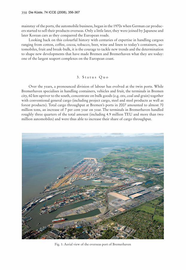
Fig. 2: Aerial view of the ports of Bremen City
Die Küste, 74 ICCE (2008), 356-367

360
Sea freight transhipment in the city of Bremen is divided between several different sites: Neustädter Hafen on the left bank of the Weser, the industrial port (Industriehafen) on the right, behind Oslebshausen lock, Mittelsbürener Hafen, and Holz- und Fabrikenhafen. He-melinger Hafen handles mainly inland waterway traffic. In contrast to Bremerhaven, the majority of these port areas and also the infrastructure are owned by private terminal opera-tors, which focus mainly on conventional general cargo. The goods include steel products, scrap metal, machinery and entire factory plants, pipes, paper, timber and pulp.
The Neustädter port area on the left bank of the Weser, with its 2340-metre long quay and water depth of up to 11.30 metres, annually handles more than three million tons of general and project cargo, whereas the Mittelsbürener port area focuses mainly on iron ore and coal distribution to the nearby steel plant. The companies within the industrial port together handle more than 6 million tons per annum.
4. C u r r e n t C o n s t r u c t i o n P r o j e c t s
To respond to these diverse challenges and to shape the future at the beginning of the new century, Bremen has launched a massive 800 million euro port investment programme, involving primarily the enlargement of the container facilities and the construction of a new sea lock. The Container Terminal 4 project has already been completed and will come into full operation in the course of 2008. Construction work on the new sea lock “Kaiserschleuse” began in autumn 2007 and is scheduled for completion in spring 2010.
4.1 C o n t a i n e r T e r m i n a l E n l a r g e m e n t
The Container Terminal 4 project involved extending the existing 3237-metre long quay wall on the banks of the River Weser by a further 1681 m towards the north. The new quay follows the course of the navigation channel, turning off towards the north-west at an angle of 10 degrees after around 540 m. The calculated depth for the quay is 19.50 m below mean sea level, which means that on completion it will be able to handle vessels with draughts of 16 metres.
Fig. 3: Development stages of Container Terminal Bremerhaven
Die Küste, 74 ICCE (2008), 356-367
361
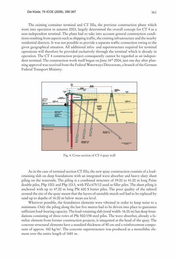
The existing container terminal and CT IIIa, the previous construction phase which went into operation in autumn 2003, largely determined the overall concept for CT 4 as a non-independent terminal. The plans had to take into account general construction condi-tions resulting from aspects such as shipping traffic, the existing infrastructure and the nearby residential districts. It was not possible to provide a separate traffic connection owing to the given geographical situation. All additional infra- and superstructure required for terminal operations will therefore be provided exclusively through the terminal which is already in operation. The CT 4 construction project consequently cannot be regarded as an indepen-dent terminal. The construction work itself began on June 16th 2004, just one day after plan-ning approval was received from the Federal Waterways Directorate, a branch of the German Federal Transport Ministry.
As in the case of terminal section CT IIIa, the new quay construction consists of a load-retaining slab on deep foundations with an integrated wave absorber and heavy-duty sheet piling on the waterside. The piling is a combined structure of 39.00 to 41.00 m long Peine double piles, PSp 1001 and PSp 1013, with PZa 675/12 used as filler piles. The sheet piling is anchored with up to 47.00 m long PSt 600 S batter piles. The poor quality of the subsoil around the site of the quay meant that the layers of unstable marsh soil had to be replaced by sand up to depths of 16.00 m below mean sea level.
Wherever possible, the foundation elements were vibrated in order to keep noise to a minimum. Only the piling along the last five metres had to be driven into place to guarantee sufficient load-bearing capacity. The load-retaining slab (total width: 16.00 m) has deep foun-dations consisting of three rows of PSt 500/158 steel piles. The wave absorber, already a fa-miliar element from former construction projects, is integrated at the head of the quay. The concrete structural elements have a standard thickness of 90 cm and a reinforcement compo-nent of approx. 160 kg/m³. The concrete superstructure was produced as a monolithic ele-ment over the entire length of 1681 m.
Fig. 4: Cross-section of CT 4 quay wall
Die Küste, 74 ICCE (2008), 356-367
362
The hinterland of CT 4 covers an area of around 900,000 m². A total of roughly 10 mil-lion m³ of sand was needed to raise the level of the entire area. The material itself was obtained by hopper dredgers during maintenance work on the fairways of the Outer Weser and the River Jade. As another part of the overall project, the “Weddewarder Tief”, a watercourse that drains the marshy areas to the north of Bremerhaven, had to be rerouted and given a new tidal outlet, so that it now flows into the River Weser to the north of the new terminal site.
To improve hinterland connectivity, the new facilities will also be linked up to a direct rail connection in the course of 2008, with six loading sidings on the eastern boundary. The storage and shunting tracks will also be enlarged in order to cope with the additional traffic volume.
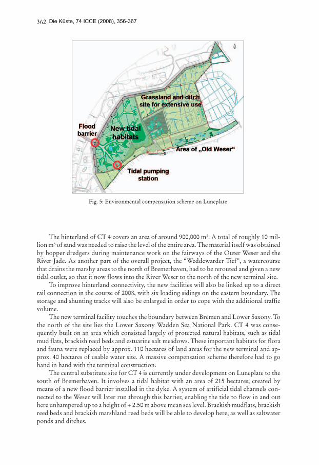
The new terminal facility touches the boundary between Bremen and Lower Saxony. To the north of the site lies the Lower Saxony Wadden Sea National Park. CT 4 was conse-quently built on an area which consisted largely of protected natural habitats, such as tidal mud flats, brackish reed beds and estuarine salt meadows. These important habitats for flora and fauna were replaced by approx. 110 hectares of land areas for the new terminal and ap-prox. 40 hectares of usable water site. A massive compensation scheme therefore had to go hand in hand with the terminal construction.
The central substitute site for CT 4 is currently under development on Luneplate to the south of Bremerhaven. It involves a tidal habitat with an area of 215 hectares, created by means of a new flood barrier installed in the dyke. A system of artificial tidal channels con-nected to the Weser will later run through this barrier, enabling the tide to flow in and out here unhampered up to a height of + 2.50 m above mean sea level. Brackish mudflats, brackish reed beds and brackish marshland reed beds will be able to develop here, as well as saltwater ponds and ditches.
Fig. 5: Environmental compensation scheme on Luneplate
Die Küste, 74 ICCE (2008), 356-367

363
The plans envisage a 240-hectare extensively used grassland and ditch site for the east of this tidal polder. This will further improve the area’s function as a breeding and resting habitat for migrating birds. Arable land will be converted into grassland for this purpose.
A second compensation measure is under development in the north of Bremerhaven, on the Wursten coastline, where the summer dykes have been opened along a width of 20 to 50 m at 10 different points. This enables high tides from the North Sea to flood the area in front of the main dyke and consequently enhance the ecological quality of the Lower Saxony Wadden Sea National Park.
Container Terminal 4 marks the end of the enlargement process of the container facili-ties in Bremerhaven for the time being, so that the capacity of the overall terminal complex now ranges – depending on the operational terminal system – from 7 to 9 million TEU an-nually.
4.2 E n l a r g e m e n t o f V e s s e l T u r n i n g Z o n e
While work on the new quay wall was already under way, another important project was initiated to cope with the sharp increase in shipping traffic in front of the container terminals, with container vessels arriving, departing, shifting and turning, and more and more ships passing en route to and from the other terminals in the port cluster of Bremen, Bremerhaven, Brake and Nordenham, as well as the rapid increase in the size of the vessels. This critical combination forced bremenports to enlarge the vessel turning zone in front of the container terminal to facilitate and guarantee safe ship traffic in the future.
Fig. 6: EMMA MAERSK at her maiden call in September 2006 in Bremerhaven
Die Küste, 74 ICCE (2008), 356-367
364
Compared with the usual planning periods required in Germany, the approval process for the project took the spectacularly short period of less than one year and dredging work began for the removal of nearly 2.3 million cubic metres of sand and silt. This created a tur-ning zone which enables two very large container vessels to turn in front of the terminal si-multaneously. The new turning zone integrates the old basin, once planned by the Federal Waterways and Shipping Authority for a 300-metre class ship, and gives the new basin a total length of 2600 metres and a width of 600 metres. Following this enlargement of the vessel turning zone to accommodate the new 400-metre class ships, Bremerhaven is now the only German seaport with scheduled calls from the world’s largest container vessels.
Dredging works to deepen the River Weser by roughly one metre will be carried out in 2008/2009, aimed at further improving seaward access. This will enable mega-container ves-sels with a draught of 13.80 metres to access Bremerhaven independent of the tide.
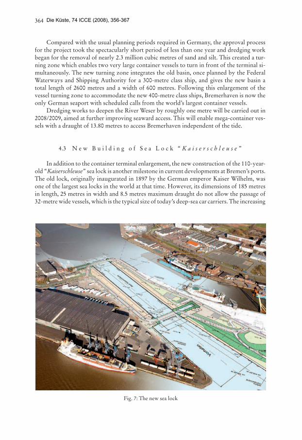
4.3 N e w B u i l d i n g o f S e a L o c k “ K a i s e r s c h l e u s e ”
In addition to the container terminal enlargement, the new construction of the 110-year-old “Kaiserschleuse” sea lock is another milestone in current developments at Bremen’s ports. The old lock, originally inaugurated in 1897 by the German emperor Kaiser Wilhelm, was one of the largest sea locks in the world at that time. However, its dimensions of 185 metres in length, 25 metres in width and 8.5 metres maximum draught do not allow the passage of 32-metre wide vessels, which is the typical size of today’s deep-sea car carriers. The increasing
Fig. 7: The new sea lock
Die Küste, 74 ICCE (2008), 356-367
365
maintenance and repair costs and especially the dependency on just one suitable seaward access gateway to the automobile terminals, the northern lock, were the main reasons for the decision made by the Senate of Bremen in 2005 to build the new lock.
The 230 million euro project began with the driving in of the first pile in autumn 2007 and is scheduled for completion in spring 2010. The new lock will be 305 metres long and 55 metres wide, guaranteeing that the car carriers of the future, even assuming the forecast new Panamax dimensions, will be able to serve the automobile logistics centre of Bremerhaven.
4.4 C r e a t i o n o f N e w B e r t h s f o r A u t o m o b i l e H a n d l i n g
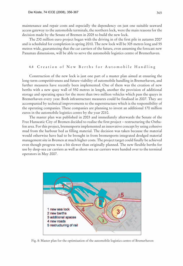
Construction of the new lock is just one part of a master plan aimed at ensuring the long-term competitiveness and future viability of automobile handling in Bremerhaven, and further measures have recently been implemented. One of them was the creation of new berths with a new quay wall of 550 metres in length, another the provision of additional storage and operating space for the more than two million vehicles which pass the quays in Bremerhaven every year. Both infrastructure measures could be finalised in 2007. They are accompanied by technical improvements to the superstructure which is the responsibility of the operating companies. These companies are planning to invest an additional 170 million euros in the automobile logistics centre by the year 2010.
The master plan was published in 2003 and immediately afterwards the Senate of the Free Hanseatic City of Bremen decided to realise the first project – restructuring the Ostha-fen area. For this project, bremenports implemented an innovative concept by using cohesive mud from the harbour bed as filling material. The decision was taken because the material would otherwise have had to be brought in from bremenports integrated dredged material management site in Bremen at much higher costs. The project target could finally be achieved even though progress was a bit slower than originally planned. The new flexible berths for use by deep-sea car carriers as well as short-sea car carriers were handed over to the terminal operators in May 2007.
Fig. 8: Master plan for the optimisation of the automobile logistics centre of Bremerhaven
Die Küste, 74 ICCE (2008), 356-367
366
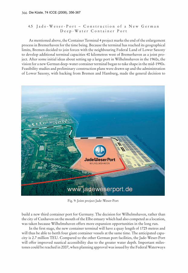
4.5 J a d e - W e s e r - P o r t – C o n s t r u c t i o n o f a N e w G e r m a n D e e p - W a t e r C o n t a i n e r P o r t
As mentioned above, the Container Terminal 4 project marks the end of the enlargement process in Bremerhaven for the time being. Because the terminal has reached its geographical limits, Bremen decided to join forces with the neighbouring Federal Land of Lower Saxony to develop additional terminal capacities 40 kilometres west of Bremerhaven as a joint pro-ject. After some initial ideas about setting up a large port in Wilhelmshaven in the 1960s, the vision for a new German deep-water container terminal began to take shape in the mid-1990s. Feasibility studies and preliminary construction plans were drawn up and the administration of Lower Saxony, with backing from Bremen and Hamburg, made the general decision to
build a new third container port for Germany. The decision for Wilhelmshaven, rather than the city of Cuxhaven on the mouth of the Elbe estuary which had also competed as a location, was taken because Wilhelmshaven offers more expansion opportunities in the long run.
In the first stage, the new container terminal will have a quay length of 1725 metres and will thus be able to berth four giant container vessels at the same time. The anticipated capa-city is 2.7 million TEU. Compared to the other German port facilities, the Jade-Weser-Port will offer improved nautical accessibility due to the greater water depth. Important miles-tones could be reached in 2007, when planning approval was issued by the Federal Waterways
Fig. 9: Joint project Jade-Weser-Port
Die Küste, 74 ICCE (2008), 356-367
367
Directorate and the operating concession was awarded to Eurogate, the leading European container terminal operator. Construction is scheduled to begin in spring 2008 and the whole terminal will become operational at the beginning of the next decade.
5. U p c o m i n g P r o j e c t s
On realisation of the above projects, the port facilities in the Federal Land of Bremen will be well prepared for the future, although there is still a great deal to be done in terms of upgrading the hinterland infrastructure transportation system for all modes of transport.
It is vital for the rail terminals in Bremen and Bremerhaven that diverse projects are implemented as soon as possible. This applies above all to upgrading the Bremen rail node – a measure which will eliminate time-consuming bottlenecks in the city. The road connec-tions to the twin ports also have to be improved, with priority going to completion of the A 281 orbital motorway around Bremen, and expanding the A 1 motorway to six lanes. In-creasing attention must also be given to planning the A 22 coastal motorway, which will provide a better link between the Weser ports and the economic regions of the Baltic within the next decade. The inland waterway connection will be improved by deepening the Middle Weser, where two locks also have to be upgraded to cope with high-powered barge trans-ports. This will generate new impetus for Bremen as an inland shipping location.
In addition to the growing cargo handling activities, industrial enterprises will in future also boost the development of Bremen’s ports. Plans are currently being drawn up to build a huge new dry dock for shipbuilding and repairs. The construction of new coal and gas power stations is under discussion and new production facilities for offshore windmills are being built. The upcoming completion of these projects will tremendously improve the competitive position of local companies and will round off the product and service portfolio at the ports.
As the largest investment project in Bremen’s port history is currently in progress, no further spectacular port development measures can be anticipated in the near future, although it is quite likely that this situation will be reconsidered when the current measures start to bear fruit. In this age of continuous growth, this could well be far earlier than we currently believe.
Die Küste, 74 ICCE (2008), 356-367