Embed Size (px)
Citation preview

ENCLOSURE 5 ITEM 5
Brecon Beacons National Park Authority
PLANNING, ACCESS, AND RIGHTS OF WAY
COMMITTEE
21 October 2014
RECOMMENDATIONS OF THE DIRECTOR OF
PLANNING ON APPLICATIONS FOR DETERMINATION
BY
THE PLANNING, ACCESS AND RIGHTS OF WAY
COMMITTEE

ENCLOSURE 5 ITEM 5
INDEX
ITEM REFERENCE ADDRESS RECOMMENDATION
1 12/08575/OUT Cwrt Y Gollen Army Camp
Crickhowell
Powys
NP8 1TF
Permit subject to Section
106 Agreement
2 13/09861/FUL 30 High Street
Brecon
Powys
LD3 7AN
Permit subject to Section
106 Agreement
3 13/09860/LBC 30 High Street Brecon
Powys
LD3 7AN
Minded to Permit
4 13/10186/FUL Land Off High Street
Talgarth
Powys
LD3 0PG
Permit subject to Section
106 Agreement
5 13/10289/OUT Land at end of
Ty Clyd Close
Govilon
Abergavenny
NP7 9PJ
Permit subject to Section
106 Agreement
6 14/10930/FUL Upper Talybryn
Llansanffraed
Aberhonddu
Powys
LD3 7JQ
Permit
7 14/11027/FUL Ewan Brook Farm
Cwmdu
Crickhowell
NP8 1SB
Permit
8 14/11135/FUL Waterfall Cottage
Ffrwdgrech
Brecon
Powys
Permit
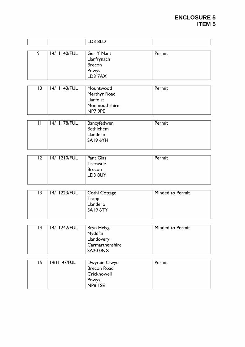
ENCLOSURE 5 ITEM 5
LD3 8LD
9 14/11140/FUL Ger Y Nant
Llanfrynach
Brecon
Powys
LD3 7AX
Permit
10 14/11143/FUL Mountwood
Merthyr Road
Llanfoist
Monmouthshire
NP7 9PE
Permit
11 14/11178/FUL Bancyfedwen
Bethlehem
Llandeilo
SA19 6YH
Permit
12 14/11210/FUL Pant Glas
Trecastle
Brecon
LD3 8UY
Permit
13 14/11223/FUL Cothi Cottage
Trapp
Llandeilo
SA19 6TY
Minded to Permit
14 14/11242/FUL Bryn Helyg
Myddfai
Llandovery
Carmarthenshire SA20 0NX
Minded to Permit
15 14/11147/FUL Dwyrain Clwyd
Brecon Road
Crickhowell
Powys
NP8 1SE
Permit

ENCLOSURE 5 ITEM 5
ITEM NUMBER: 5
APPLICATION NUMBER: 13/10289/OUT
APPLICANTS NAME(S): Mr Dai Hawkins
SITE ADDRESS: Land at end of
Ty Clyd Close
Govilon
Abergavenny
NP7 9PJ
GRID REF: E: 326876 N:214050
COMMUNITY: Llanfoist Fawr
DATE VALIDATED: 27 June 2014
DECISION DUE DATE: 22 August 2014
CASE OFFICER: Mr Jonathan James
PROPOSAL Residential Development
ADDRESS Land at end of Ty Clyd Close, Govilon, Abergavenny

ENCLOSURE 5 ITEM 5
CONSULTATIONS/COMMENTS
Consultee Received Comments
Dwr Cymru Welsh
Water - Developer
Services
4th Feb 2014 As the applicant intends utilising a private treatment
works we would advise that the applicant contacts
the Environment Agency who may have an input in
the regulation of this method of drainage disposal.
However, should circumstances change and a
connection of the public sewerage sustem/public
sererage treatment works is preferred we must be
re-consulted on this application.
No problems are envisaged with the provision of
water supply for this development.
Our response is based on the information provided
by your application. Should the proposal alter
during the course of the application process we
kindly request that we are re-consulted and reserve
the right to make new representation.
Dwr Cymru Welsh
Water - Developer
Services
21st Jul 2014 We refer to your planning consultation relating to
the above site, and we can provide the following
comments in respect to the proposed development.
SEWERAGE
As the applicant intends utilising a private treatment
works we would advise that the applicant contacts
the Environment Agency who may have an input in
the regulation of this method of drainage disposal.
However, should circumstances change and a
connection to the public sewerage system/public
sewerage treatment works is preferred we must be
re-consulted on this application.
WATER SUPPLY
Dwr Cymru Welsh Water has no objection to the
proposed development.
Our response is based on the information provided
by your application. Should the proposal alter
during the course of the application process we
kindly request that we are re-consulted and reserve
the right to make new representation.
ENCLOSURE 5 ITEM 5
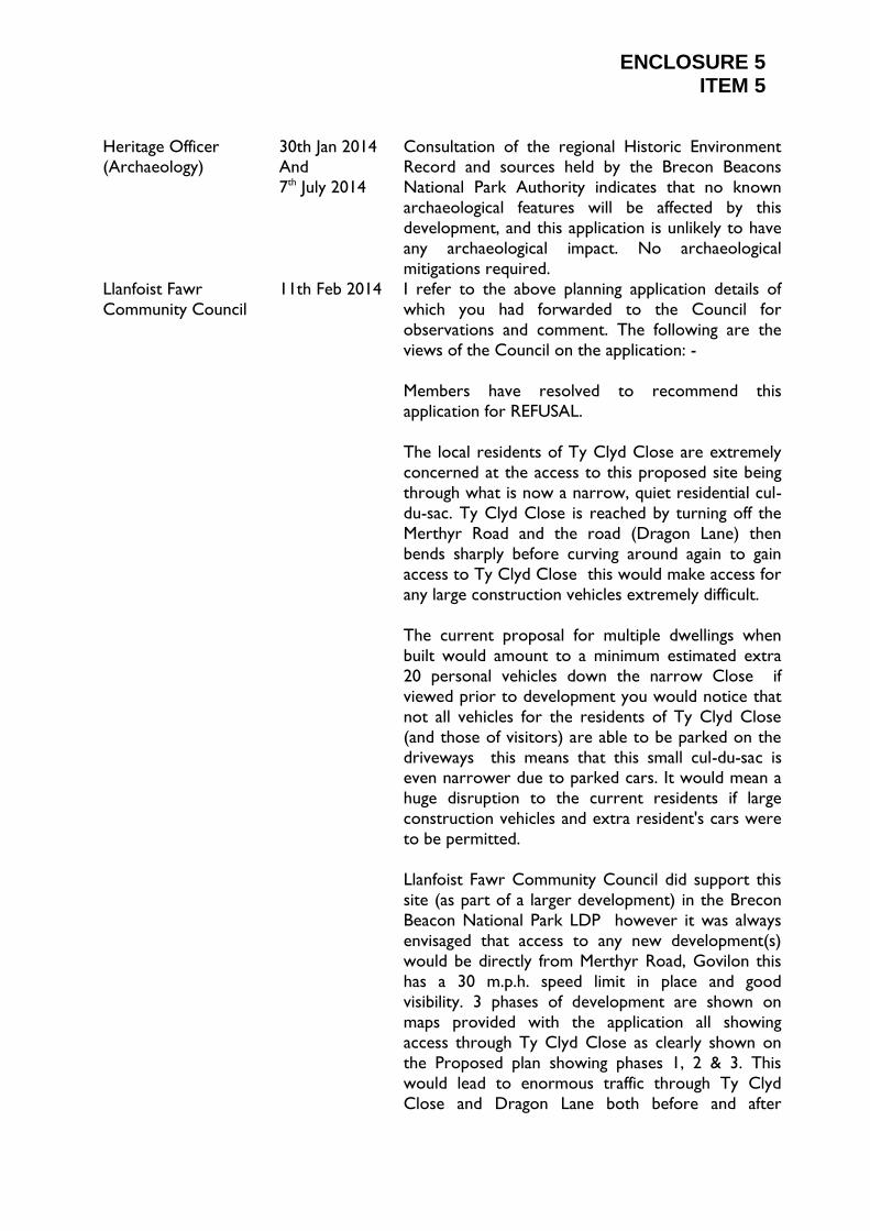
Heritage Officer (Archaeology)
30th Jan 2014 And
7th July 2014
Consultation of the regional Historic Environment Record and sources held by the Brecon Beacons
National Park Authority indicates that no known
archaeological features will be affected by this
development, and this application is unlikely to have
any archaeological impact. No archaeological
mitigations required.
Llanfoist Fawr
Community Council
11th Feb 2014 I refer to the above planning application details of
which you had forwarded to the Council for
observations and comment. The following are the
views of the Council on the application: -
Members have resolved to recommend this
application for REFUSAL.
The local residents of Ty Clyd Close are extremely
concerned at the access to this proposed site being
through what is now a narrow, quiet residential cul-
du-sac. Ty Clyd Close is reached by turning off the
Merthyr Road and the road (Dragon Lane) then
bends sharply before curving around again to gain
access to Ty Clyd Close this would make access for
any large construction vehicles extremely difficult.
The current proposal for multiple dwellings when
built would amount to a minimum estimated extra
20 personal vehicles down the narrow Close if
viewed prior to development you would notice that
not all vehicles for the residents of Ty Clyd Close
(and those of visitors) are able to be parked on the
driveways this means that this small cul-du-sac is even narrower due to parked cars. It would mean a
huge disruption to the current residents if large
construction vehicles and extra resident's cars were
to be permitted.
Llanfoist Fawr Community Council did support this
site (as part of a larger development) in the Brecon
Beacon National Park LDP however it was always
envisaged that access to any new development(s)
would be directly from Merthyr Road, Govilon this
has a 30 m.p.h. speed limit in place and good
visibility. 3 phases of development are shown on
maps provided with the application all showing
access through Ty Clyd Close as clearly shown on
the Proposed plan showing phases 1, 2 & 3. This
would lead to enormous traffic through Ty Clyd
Close and Dragon Lane both before and after

ENCLOSURE 5 ITEM 5
building work.
There is also concern over the proposed sewage
treatment proposal - this is to be sited in an area
that has always been used for turning vehicles and is
very close to the neighbouring property it is sited
on existing land in Ty Clyd Close and not on land
proposed as part of the new development surely any
treatment works required should be on land that is
part of the new development and not a burden on
existing long term residents.
It is accepted that Shirley Wiggam has been
consulted regarding the affordable housing provision
but before any firm proposals are agreed it should
be noted that affordable housing flats have been
provided, within the Llanfoist Fawr C.C. area, on
Gavenny Gate, Llanfoist and local Cllrs. would prefer
to see a more suitable LOCAL affordable housing
provision on a shared ownership basis this would
reflect the real needs of the small village to enhance
regeneration. Llanfoist Fawr C.C. is proposing to
work with David James, Rural Housing Enabler and
would like a chance to submit more suitable
proposals for all 3 phases of this development.
As this development is likely to be 3 phases it would
be a mistake (as seen in Llanfoist on the Whitecastle
/ Gavenny Gate development) to look at the
planning in separate sections.
This is a chance for B.B.N.P. Planners to show real sympathy with residents already within the National
Park who do not object to development but would
ask that the site is treated as one whole
development and planned accordingly with a view to
enhancing the village. By treating this as a small
development the developer, who clearly wishes to
build more homes, is able to get away with not
looking at on site recreation very much needed and
requested by current residents in this part of the
village and would be most appreciated by any new
residents particularly those with younger children.
Currently residents have to walk out of the village
for all outdoor children's and adult recreation
facilities - this would be a chance to get a good
facility within this part of the village. The approved
planning application for the development of the
former Govilon Primary School site, in the same

ENCLOSURE 5 ITEM 5
part of the village has shown much better design can be achieved. (This includes a village green element
and was fully supported and approved by the
Llanfoist Fawr Community Council.)
Planning Obligations Statement of Intent - Mr Tim
O'Donovan has indicated that M.C.C. would require
a contribution for off-site provision relating to
Children's Play, Open Space and Adult Recreation -
please note that all land for this purpose within the
village is in the sole Trusteeship of the Llanfoist Fawr
Community Council (King George V Playing Field)
and any monies made available from this
development would need to be given for use by
Llanfoist Fawr Community Council as
Monmouthshire County Council do not have any
land or facilities within the village
Local Councillors would welcome the chance to
view the site with B.B.N.P. planners and work with
the National Park to have a high quality development
within a village that is eager for regeneration since
losing its Primary School and Post Office.
Monmouthshire
County Council
Affordable Housing
No comments received
Monmouthshire
County Council
Education
No comments received
Monmouthshire County Council
Environmental Health
11th Jul 2014 No comments received
Monmouthshire
County Council
Highways
11th Feb 2014 The application was the subject of previous
proposals and pre application advice given.
General Layout
The site is proposed as a continuation of the existing
Public highway. The proposal however is to amend
the existing layout by removing the turning head.
This will require a stopping up order and the
process must be completed prior to commencement
of site to ensure that the order is approved.
The closure would normally follow that the highway
reverts to the adjoining land owners. In this case the
applicant is claiming to be the owner of this land
under the highway at the turning head.
The applicant proposes to utilise the land for parking
and a water treatment plant.

ENCLOSURE 5 ITEM 5
This would be subjective to the stopping up being approved at a magistrate's court.
The highway authority would only support the
closure on the completion of an adoptable turning
head within the new development. This feature has
not been shown as being provided. Without this
feature and a legal agreement to secure its
construction, the authority would be unable to
progress the stopping up of the highway.
The housing square was proposed to remain private,
and would be acceptable from a highway viewpoint.
Drainage
The proposal shows a water treatment plant
immediately adjacent to the highway on an existing
highway. The plant should be relocated away from
the adjoining highway.
Percolation tests are in an area uphill from the site
and no detail of any pumping facility is shown to take
the proposed highway surface water uphill to the
area set aside at the percolation test area.
Without details I am unable to confirm that an
access for a future public highway is sustainable.
RECOMMENDATION
I am unable to support the proposal until the turning
head details are clarified and details of highway
surface water drainage has been indicated.
It should be brought to the attention of the applicant
that in the event of a new or altered vehicular access being formed, the requirements of Section 184 of
the Highways Act 1980 must be acknowledged and
satisfied. In this respect the applicant shall apply for
permission pursuant to Section 184 of the Highways
Act 1980 prior to commencement of access works
via the MCC Highways.
I would advise you that I am the Highway Engineer
now dealing with the application from a County
Highway standpoint. I would comment on the re-
consultation as follows:-
Firstly, I would comment on the proposed use of the
existing turning head of Ty Clyd Close. Contrary to
our previous highway comments dated 11th
February 2014 we would not wish to see a highway
extinguishment of the existing turning head. Upon
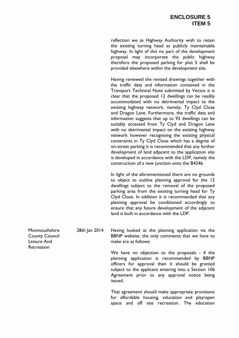
ENCLOSURE 5 ITEM 5
reflection we as Highway Authority wish to retain the existing turning head as publicly maintainable
highway. In light of this no part of the development
proposal may incorporate the public highway
therefore the proposed parking for plot 5 shall be
provided elsewhere within the development site.
Having reviewed the revised drawings together with
the traffic data and information contained in the
Transport Technical Note submitted by Vectos it is
clear that the proposed 12 dwellings can be readily
accommodated with no detrimental impact to the
existing highway network, namely; Ty Clyd Close
and Dragon Lane. Furthermore, the traffic data and
information suggests that up to 93 dwellings can be
suitably accessed from Ty Clyd and Dragon Lane
with no detrimental impact on the existing highway
network however recognising the existing physical
constraints in Ty Clyd Close which has a degree of
on-street parking it is recommended that any further
development of land adjacent to the application site
is developed in accordance with the LDP, namely the
construction of a new junction onto the B4246.
In light of the aforementioned there are no grounds
to object to outline planning approval for the 12
dwellings subject to the removal of the proposed
parking area from the existing turning head for Ty
Clyd Close. In addition it is recommended that any
planning approval be conditioned accordingly to
ensure that any future development of the adjacent land is built in accordance with the LDP.
Monmouthshire
County Council
Leisure And
Recreation
28th Jan 2014 Having looked at the planning application via the
BBNP website, the only comments that we have to
make are as follows:
We have no objection to the proposals - if the
planning application is recommended by BBNP
officers for approval then it should be granted
subject to the applicant entering into a Section 106
Agreement prior to any approval notice being
issued.
That agreement should make appropriate provisions
for affordable housing, education and play/open
space and off site recreation. The education

ENCLOSURE 5 ITEM 5
contribution should be £3,000 per unit and £3,920 per unit for off site provision of children's play, open
space and adult recreation.
It is clear from the fifth paragraph on Page 8 of the
Design and Access Statement that the applicant is
aware of these requirements but this e-mail seeks to
emphasise the need for such provisions to be
included in a Section 106 Agreement.
Monmoutshire
County Council
Building Control
I note that the development is in very close
proximity to the A465 dual carriageway and
therefore in my view the potential for disturbance of
noise from the road traffic on the use and
enjoyment of the residential properties should be
considered .
I therefore recommend that a noise assessment is
undertaken to assess which Noise Exposure
Category ( or Categories ) the proposed site falls
within as provided in Planning Guidance Wales '
Technical Advice Note ( Wales ) 11 :Noise ' . I
suggest that the whole site should be considered in
the assessment, but particular regard must be given
to the dwellings proposed in the area closest to the
A465. The report should provide appropriate
recommendations based on the Noise Exposure
Categories determined.
In addition I recommend that in view of the close proximity of existing dwellings to the proposed site ,
that any grant of planning permission is subject to a
condition ensuring construction work is undertaken
during reasonable working hours eg between 8am to
6pm mon to fri and 8am to 1pm Saturdays with no
work on Sundays / Bank Holidays or variation
thereof agreed with applicant .
Please note I have no record of being consulted
prior to your recent consultation letter.
My colleague Paul White EHO who assesses
applications with regard to air pollution /
contaminated land considerations will be appraising
this application shortly and commenting separately if
he considers necessary.

ENCLOSURE 5 ITEM 5
Natural Resources Wales/Cyfoeth
Naturiol Cymru
6th March 2014 and
17th Jul 2014
We refer the application to the attached planning advice note.
Planning Advice Note (100)
Natural Resources Wales/Cyfoeth Naturiol Cymru
This note provides guidance on environmental
planning and regulatory issues, and may be of use at
a pre-application/application stage and for the
lifetime of your activities. It is not exhaustive, and if
you have any other queries please contact our
Natural Resources Wales Customer Contact
Centre on 0300 065 3000 for further assistance.
Flooding and Flood Consequence Assessments
(FCAs)
You can obtain information on which 'flood zone'
your site is located through
www.naturalresourceswales.gov.uk /
www.cyfoethnaturiolcymru.gov.uk
Planning Policy Wales Technical Advice Note 15:
Development and Flood Risk (July 2004) provides
very important guidance on consideration of fluvial,
tidal and surface water flood risk. It includes
information on climate change; vulnerability of land
use types; justification; preparation of flood
consequence assessments (FCAs) (Appendix 1 E)
and acceptability criteria. We have also produced a
useful checklist for developers and consultants that
should be submitted in support of a FCA. To
request pre-application advice on FCAs please contact us. Please note the Local Planning Authority
(LPA) may also have their own requirements in
respect of a FCA and further advice should be
sought from them.
FCAs must assess the risks of fluvial, surface water
and other sources of flooding. Sustainable Drainage
Systems (SuDS) should be included in development
wherever possible to reduce surface water run-off.
A variety of SuDS techniques are available, which
also helps with protecting water quality and adding
amenity value to development.
Further information sources on SuDS can be found
in:
o Technical Advice Note 15: Development and
Flood Risk (TAN15) (July 2004) TAN15 - Appendix
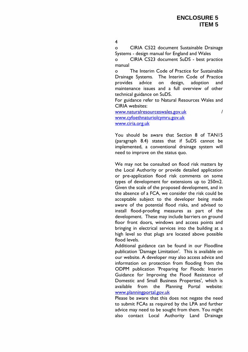
ENCLOSURE 5 ITEM 5
4 o CIRIA C522 document Sustainable Drainage
Systems - design manual for England and Wales
o CIRIA C523 document SuDS - best practice
manual
o The Interim Code of Practice for Sustainable
Drainage Systems. The Interim Code of Practice
provides advice on design, adoption and
maintenance issues and a full overview of other
technical guidance on SuDS.
For guidance refer to Natural Resources Wales and
CIRIA websites:
www.naturalresourceswales.gov.uk /
www.cyfoethnaturiolcymru.gov.uk
www.ciria.org.uk
You should be aware that Section 8 of TAN15
(paragraph 8.4) states that if SuDS cannot be
implemented, a conventional drainage system will
need to improve on the status quo.
We may not be consulted on flood risk matters by
the Local Authority or provide detailed application
or pre-application flood risk comments on some
types of development for extensions up to 250m2.
Given the scale of the proposed development, and in
the absence of a FCA, we consider the risk could be
acceptable subject to the developer being made
aware of the potential flood risks, and advised to
install flood-proofing measures as part of the
development. These may include barriers on ground floor front doors, windows and access points and
bringing in electrical services into the building at a
high level so that plugs are located above possible
flood levels.
Additional guidance can be found in our Floodline
publication 'Damage Limitation'. This is available on
our website. A developer may also access advice and
information on protection from flooding from the
ODPM publication 'Preparing for Floods: Interim
Guidance for Improving the Flood Resistance of
Domestic and Small Business Properties', which is
available from the Planning Portal website:
www.planningportal.gov.uk
Please be aware that this does not negate the need
to submit FCAs as required by the LPA and further
advice may need to be sought from them. You might
also contact Local Authority Land Drainage

ENCLOSURE 5 ITEM 5
engineers to determine any localised flooding problems from ordinary watercourses within the
vicinity of your proposals, and to confirm that
proposed surface water disposal would not cause or
exacerbate flooding.
We may have flood level data to assist in preparing a
FCA: This information may be provided for a fee and
obtained from our Natural Resources Wales
Customer Contact Centre on 0300 065 3000. For
information: we do not recommend individual FCA
consultants but the following website link is
provided to help you to source a suitably qualified
person http://www.ciwem.org.
Landfill/Landfill Gas
The location of authorised landfills is shown on our
website or contact our Natural Resources Wales
Customer Contact Centre on 0300 065 3000. Your
Local Authority has a list of closed (historic) landfill
sites. You might refer to the landfill gas website
(which includes policy and guidance) for further
information on proposed development within 250
metres of a landfill site. http://www.landfill-
gas.com/html/search.html
Land affected by Contamination
Planning Policy Wales takes a precautionary
approach to land affected by contamination. Before
the principle of development can be determined,
land contamination should be investigated to see
whether it could preclude certain development due
to environmental risk or cost of clean up (remediation). Where contamination is known or
strongly suspected, a desk study, investigation,
remediation and other works may be required to
enable safe development. Minimum requirements
for submission with a planning application are a desk
study and preliminary risk assessment, such as a site
walkover or conceptual model. Site Investigation and
Remediation Strategy reports may be required for
submission with a planning application for sensitive
land use types or where significant contamination or
uncertainty is found. We recommend that you
contact the Local Authority Environmental Health
team who may hold records on known/potential
land contamination. If during site works,
contaminated material is suspected, you are advised
to stop works and seek further guidance.
Remediation of contaminated land may also require

ENCLOSURE 5 ITEM 5
an authorisation under environmental permitting legislation (formerly waste management legislation).
For information: whilst we do not recommend
individual environmental consultants, the following
website link is provided for environmental
consultants that undertake contaminated land
assessments http://www.endsdirectory.com/
Foul Drainage
Government policy states that, where practicable,
foul drainage should be discharged to the mains
sewer. Where this is not possible and private
sewage treatment / disposal facilities are utilised,
they must be installed and maintained in accordance
with British Standard 6297 and Approved Document
H of the Building Regulations 2000. You should also
have regard to Welsh Office Circular 10/99 in
respect of planning requirements for non mains
sewerage. For planning purposes we have provided a
Foul Drainage Assessment Form to assist in your
consideration of these matters, please view our
website www.naturalresourceswales.gov.uk /
www.cyfoethnaturiolcymru.gov.uk.
You may wish to submit this to the Council with
your application. Alternatively, the Local Authority
may have its own assessment form. Our Pollution
and Prevention Guidance Note 4 'Treatment and
disposal of sewage where no foul sewer is also
available' also provides useful guidelines.
Biodiversity
The planning system in Wales has an important part
to play in maintaining, restoring and enhancing
biodiversity (Planning Policy Wales and the UK
Biodiversity Action Plan 1994). Technical Advice
Note 5 on Nature Conservation (TAN5) provides
detailed guidance on nature conservation and
includes guidance regarding wildlife corridors. A
developer should conserve and enhance special
features, which will also be a consideration as part of
our determination of consents/licences/permits.
Article 10 of the EU Habitats Directive also stresses
the importance of natural networks of linked habitat
corridors to allow movement of species between
suitable habitats, and promote the expansion of
biodiversity. River corridors are particularly
effective in this way. Such networks and corridors

ENCLOSURE 5 ITEM 5
may also help wildlife adapt to climate change. Our advice is that green buffer zones should be agreed
and permanently delineated alongside a watercourse,
be free from structures and/or planted with UK
generic provenance or left as a natural area for
wildlife. River basin management planning also
requires the restoration and enhancement of water
bodies to prevent deterioration and promote
recovery of water bodies.
If you own land or property alongside a river or
other watercourse, our guide 'Living on the Edge'
explains your rights and responsibilities as a riverside
property owner (www.naturalresourceswales.gov.uk
/ www.cyfoethnaturiolcymru.gov.uk
Your responsibilities include maintaining river beds
and banks; allowing the flow of water to pass
without obstruction; and controlling invasive alien
species such as Japanese knotweed. Sometimes
you will need permission from other bodies as well
as from us. Should a proposal affect a designated
site that has no connection to the water
environment or any BAP species/habitats then please
contact us. A license will be required from us to
survey for, and, where any proposals are made as a
last resort, to re-locate legally protected species.
Water Resources
We encourage water efficiency in all development.
For residential, we recommend a minimum standard of Level 3 of the Code for Sustainable Homes. http:/
/www.planningportal.gov.uk/uploads/
code_for_sustainable_homes_techguide.pdf For
commercial, we recommend rainwater harvesting
and grey water recycling. Development should
endeavour to meet the 'very good' rating under the
BREEAM Standard for non-residential development.
www.breeam.org
Pollution Prevention
You should incorporate pollution prevention
measures to protect ground and surface waters. We
have produced a range of guidance notes giving
advice on statutory responsibilities and good
environmental practice, which include Pollution
Prevention Guidance Notes (PPG's) targeted at the
specific activities (as listed below). Pollution

ENCLOSURE 5 ITEM 5
prevention guidance can be viewed on our website: www.naturalresourceswales.gov.uk /
www.cyfoethnaturiolcymru.gov.uk
Also, the NetRegs website has guidance, specific for
the construction sector, on environmental
regulations and good practice. Codes of Practice on
preventing pollution from agricultural activities is
available on Defra's website:
http://www.defra.gov.uk/foodfarm/landmanage/cogap
/index.htm
Environmental Permits (EPs) / Consent
Requirements - separate to Planning Permission
The granting of planning permission does not permit
activities that require consent, licence, or permit
under other legislation. It is the applicant's
responsibility to ensure that all relevant
authorisations are obtained before work
commences. Consenting procedures can take
several months to complete, and early contact is
therefore advised. Further information can be found
on our website:
www.naturalresourceswales.gov.uk
www.cyfoethnaturiolcymru.gov.uk
Flood Defence Consents
Any works (including temporary works) in, under,
over or adjacent to a 'main river' (including any
culverting) may require us to give formal permission
in the form of a Flood Defence Consent before you start any work. We operate a "no-culverting" policy
and Consent for culverting will only normally be
granted for site access purposes. Our Development
and Flood Risk Team will be able to help with this.
Please phone 0300 065 3000 - this is the general
enquiries line for the Customer Services Centre and
ask to be put through to the team that covers your
area if you would like further advice or to apply for
a Consent.
Please be aware that on 6 April 2012, when a
further phase of the Flood and Water Management
Act 2010 was implemented, responsibility for
regulating activities (issuing consents; and
undertaking enforcement action) on 'ordinary
watercourses' in most areas of England and Wales
transferred from the Environment Agency to lead
ENCLOSURE 5 ITEM 5
local flood authorities, for example, Unitary Authorities, or Internal Drainage Districts (IDDs).
Please refer to the relevant organisation for consent
applications.
Fish Stocking
Our consent is needed before any fish can be
introduced or removed from a watercourse or
fishery. This applies to all waters, both public and
private. The only exceptions are fish farms and
domestic waters (e.g. garden ponds) which are less
than one acre in area and which are not fished.
Here you can find out about online methods of fish
movement consenting
www.naturalresourceswales.gov.uk /
www.cyfoethnaturiolcymru.gov.uk
Discharge (of Effluent) to ground or surface waters
You will need to apply for a Permit, or Exemption, if
you wish to discharge anything apart from
uncontaminated surface water to a
watercourse/ditch. You may also need to apply for a
Permit from our National Permitting Team to allow
certain discharges into ground. You must obtain any
necessary Permit prior to works starting on site.
The Welsh Government has also advised that all
septic tanks and small sewage treatment plant
discharges in Wales will need to be registered.
More information, including a step by step guide to
registering, is available on our website
www.naturalresourceswales.gov.uk / www.cyfoethnaturiolcymru.gov.uk
Environmental Permits (EPs) (formerly Waste
Management Licences + Pollution Prevention
Control Permits)
Waste arising from development, must be handled in
accordance with relevant environmental permitting
legislation. Waste must be minimised and options
for reuse or recycling should be investigated before
it is sent for disposal. Importation of waste material
onto site (e.g. hardcore for construction) will
require a waste authorisation, which may be an EP;
although in most cases will be the registration of an
exemption from the need for an EP. If the purpose
of development is to create a waste management
facility (e.g. landfill, incinerator, transfer/recycling
centre, scrapyard, contaminated land remediation,
ENCLOSURE 5 ITEM 5
anaerobic digestion or composting plant), some form of waste management authorisation will be required,
in the form of an EP (previously WMLs or PPC
Permits). For further information contact us on Tel.
0300 065 3000 - this is the general enquiries line for
the Customer Services Centre or visit our web site
at www.naturalresourceswales.gov.uk /
www.cyfoethnaturiolcymru.gov.uk
Environmental Permitted Sites
Under the Environmental Permitting (England and
Wales) Regulations 2010 permitted sites should not
cause harm to human health or pollution of the
environment and any emissions should meet
regulatory requirements and technical standards.
The operator is required to have appropriate
measures in place at the site to prevent pollution to
the environment, harm to human health the quality
of the environment, detriment to the surrounding
amenity, offence to a human sense or damage to
material property.
Other EPs may also be required
For example, to abstract surface or groundwater, to
impound water bodies, and for Industrial and
Intensive Pig & Poultry (formerly Integrated &
Pollution Prevention Control Permits). Contact us
on Tel. 0300 065 3000 - this is the general enquiries
line for the Customer Services Centre. To apply for
an EP please view our website at:
www.naturalresourceswales.gov.uk / www.cyfoethnaturiolcymru.gov.uk
Further Information
Information on protecting and enhancing the
environment, and the location of features such as
Source Protection Zones, can be obtained from our
website: www.naturalresourceswales.gov.uk /
www.cyfoethnaturiolcymru.gov.uk
Pollution Prevention Guidance Notes (PPG's) are
available on the following topics:
PPG01 General guide to the prevention of water
pollution
PPG02 Above ground oil storage tanks
PPG03 The use and design of oil separators

ENCLOSURE 5 ITEM 5
PPG04 Disposal of sewage where no mains drainage available
PPG05 Works in, near or liable to effect
watercourses
PPG06 Working at construction and demolition
sites
PPG07 Refuelling facilities
PPG08 Storage and disposal of used oils
PPG13 High pressure water and steam cleaners
PPG18 Control of spillages and fire fighting run-off
PPG20 Dewatering underground ducts and
chambers
PPG21 Pollution incident response planning
PPG22 Dealing with spillages on highways
PPG26 Storage and handling of drums & immediate
bulk containers
PPG27 Installation, decommissioning and removal of
underground storage tanks
PPG28 Controlled Burn
NP Head Of Strategy
Policy And Heritage
10th Feb 2014 The development plan for the area is the Brecon
Beacons National Park Local Development Plan
2007-2022 (hereafter LDP) which was adopted by
resolution of the National Park Authority on the
17th December 2013.
My observations relate to the proposals compliance
with the strategy and policy of the LDP.
Proposal
The proposal seeks outline permission for the
development of 10 units on an allocated site within
the settlement boundary of Govilon.
LDP Policy Context
Govilon is listed as a settlement in the LDP as
defined by the LDP Proposals Map. Govilon itself is
a relatively large settlement along the A465 heads of
the valley trunk road corridor. Its location affords
Govilon a strategic function, providing linkages
between the National Park and larger service
centres such as Abergavenny outside of our
boundary. Predominately as a result of its location
housing need in Govlion is significant. During the
development of the LDP Govilon was afforded a
large housing allocation. The scale of this allocation
ENCLOSURE 5 ITEM 5
is reflective of both its strategic function in the East of the Park and the status of the existing settlement.
This proposal is located on a part of this allocation
(reference CS39/69/70/88/89/99 hereafter CS39).
CS39 is allocated for 93 units, it is anticipated that
the site will be available for development towards
the end of the plan period (Table 6.1 of the LDP).
The applicants DAS states that there is an intention
to develop the entirety of the allocation in three
phases, with the proposal before us forming the first
phase of development. I refer you to my pre-
application observations regarding this proposal
where I set out the following
'I have concerns that permission for partial
development of the site may have future
repercussions for development of the remainder of
the site…. Similarly I have some concerns regarding
the proposed layout and how it will relate to
development on the remainder of the LDP allocation
(CS39). I would suggest that it would be in the
applicant's interest to develop an indicative layout
which encompasses the whole of the LDP allocation
area. This is so as the NPA can be certain that a
permission (or permissions) in this section of the
allocation would not impact on the viability of the
remainder of the area being developed. I would
suggest that this should form part of the DAS for
any future application.
These observations were made in light of LDP objectives regarding provision of housing land and
the sustainable use of land. The LDP sets out that in
providing land for development the NPA's aim is to
ensure that landscape change is justifiable and not
wasteful in terms of land take (8.11.2). The LDP is
founded upon an Environmental Capacity Approach
to Sustainable Development which carefully
considered the appropriateness of all allocated
development sites, including the viability of their
delivery and their impact upon the landscape if
developed. All land allocated for development is
made with the intention that it will contribute
towards the housing needs of our communities.
This position is supported in both strategic policies
SP5 Housing and SP18 Sustainable Use of Land. As
such, in considering a proposal for a phased delivery
of an allocation it is vital that the NPA are able to

ENCLOSURE 5 ITEM 5
have an indication as to how the entirety of the site can be developed. I note that some indication of the
3 phases of development has been put forward.
However this only provides an indication of layout
for the partial development of the site, accounting
for 21 of the anticipated 93 units. This provides
insufficient information in order to determine how
the proposal adequately utilises the allocation site.
I also note that in order to bring the development
forward in advance of the improvements to the
Aberbaiden STW the applicant proposes the
installation of a temporary private sewage treatment
unit, necessitating the need to utilise part of the
allocation site for a soakaway. I have significant
concerns whether this represents the most
sustainable use of land, and whether alternative
provision could be made to service the
development. Again, it would be necessary for the
applicant to demonstrate how the soakaway will
impact on the development of the remaining
allocation. This issue must be addressed prior to
determination. I request policy and strategy are
reconsulted once this information is provided by the
applicant.
I note that 20% of the scheme is to be provided as
affordable housing. The applicant's DAS states that
this level of provision has been agreed by MCC
housing section and that they are satisfied if the
remaining 10% contribution (required under LDP policy 28) is provided as commuted sum.
In keeping with this position the commuted sum will
be calculated using the formula set out in appendix 5
of the draft .
Commuted sums are calculated on the basis of a
percentage of Welsh Government Acceptable costs
Guidance (ACG). ACG issued by the Welsh
Government is a recognised measure of the cost of
providing affordable housing in different
communities in Wales.
Therefore the calculation of commuted sums is
based on the principle of equating the developer
contribution with the accepted Welsh Government
Grant level of 58% of the ACG.

ENCLOSURE 5 ITEM 5
The forma for the calculation for the calculation of
the commuted sum will therefore be
Commuted sum Contribution = A x B x C
Where
A= number of units
B= 58% of ACG (for relevant property type and
band area)
C= % of relevant submarket area,
For the above proposal, the following applies
A= 1 unit
B= Govilon is located within ACG Band 4. A 6
person, 4 bedroom house within band 5 has an ACG
of £191,400. 58% of ACG equates to £111,012
C= 10% total contribution
As such the calculation is as follows 1 x 111,012 x
0.1 = £11,101.20
This contribution must be agreed by S106 on the
grant of planning permission. Failure to do without
agreement by the NPA will result in the proposal
failing the requirements of LDP policy 28 and the
strategy and policy team would uphold an objection
to the proposal.
In accordance with appendix 4 of the draft SPG if it
can be reasonably demonstrated in writing by the
applicant to the satisfaction of the NPA that there
are significant factors which mean that the scheme is
unviable at the target affordable housing
contribution as set out in policy 28, the NPA will
seek to verify this using the 3 Dragons Development
Appraisal Toolkit (or equivalent process) with a final
recourse to the District Valuer. Disputes of viability
referred to the District Valuer will be charged at
cost to the Developer. Affordable Housing will still
be required at a level proven to be viable through
the above verification process.
Recommendation:
The strategy and policy team have significant
reservations relating to the proposed development.

ENCLOSURE 5 ITEM 5
It is unclear how the proposal will relate to the development of the LDP allocation CS39. Without
this information we are unable to determine
whether the proposal meets the requirements of
SP18 in so much as it presents the best possible use
of available development land.
Further detail should be provided, demonstrating
how the proposal 'sits' within the wider
development of allocation CS39. If this information
cannot be provided then the policy and strategy
team will maintain their objection to the proposal.
NP Planning Ecologist 11th Feb 2014
and
24th Jul 2014
A. Planning Policy & Guidance
o To comply with Planning Policy Wales
(2014), section 5.5 and also TAN 5, biodiversity
considerations must be taken into account in
determining planning applications. Planning
permission should be refused if the proposals will
result in adverse harm to wildlife that cannot be
overcome by adequate mitigation and compensation
measures.
o The adopted Local Development Plan for the
BBNP includes the following policies regarding
ecological issues and safeguarding biodiversity:
o SP3 Environmental Protection - Strategic
Policy
o Policy 3 Sites of European Importance
o Policy 4 Sites of National Importance
o Policy 5 Sites of Importance for
Nature Conservation o Policy 6 Biodiversity and Development
o Policy 7 Protected and Important Wild
Species
o Policy 8 Trees and Development
o Policy 9 Ancient Woodland and
Veteran Trees
B. Legislation
o Environment Act 1995 - the first Statutory
Purpose of the National Park is to conserve and
enhance the natural beauty, wildlife and cultural
heritage of the National Park
o NERC Act 2006 - Section 40 requires local
authorities to have due regard to conserving
biodiversity. This includes reference to the list of
priority species and habitats produced under Section
42 of the Act.
ENCLOSURE 5 ITEM 5
o Conservation of Habitats & Species Regulations 2010 (as amended) - Regulation 9
requires local authorities to take account of the
presence of European Protected Species at
development sites. If they are present and affected
by the development proposals, the Local Planning
Authority must establish whether "the three tests"
have been met, prior to determining the application.
The three tests that must be satisfied are:
i. That the development is "in the interests of
public health and public safety, or for other
imperative reasons of overriding public interest,
including those of a social or economic nature and
beneficial consequences of primary importance for
the environment".
ii. That there is "no satisfactory alternative"
iii. That the derogation is "not detrimental to
the maintenance of the populations of the species
concerned at a favourable conservation status in
their natural range"
C. Comments
1. Thank you for consulting me on the above
application. I previously provided comments on 10th
February 2014. I have amended my comments below
to address the recently submitted information.
2. The land is on the edge of Govilon to the
south of the A465 and allocated for housing in the
LDP for the BBNP. The development proposals are
in outline for the construction of housing; the
proposed site plan is for 14 houses/flats. The proposals do not now include a "proposed
drainfield" to accommodate foul and surface water
treatment.
3. I have reviewed the documents and drawings
submitted with the application, which includes the
following ecological information:
o Land at Ty Clyd Close, Govilon,
Monmouthshire - A Phase 1 Ecological Assessment
by Just Mammals (July 2011)
o Tree survey, constraints and tree protection
plan by Wyn Davies (22nd November 2013)
4. No evidence of protected species was found
on the land that is the subject of this planning
application. A bat dropping was found in the
collapsed building to the east, but this is outside the
current application site.
5. I endorse the recent comments of the

ENCLOSURE 5 ITEM 5
BBNPA tree officer regarding the impact of the proposed route of the mains sewer and the impact
this will have on the trees and hedgerow along the
north-west boundary of the site. An alternative
route should be proposed, such as along the
northern boundary if possible?
6. The aerial photos of the site from 2010 show
a hedgerow marking much of the eastern boundary
of the application site. I was disappointed to see that
most of the hedgerow shrubs have been cut off at
the base; there does not appear to be any regrowth,
probably because the young shoots have not been
protected from grazing animals. This would
therefore appear to be hedgerow removal and in
contravention of the Hedgerow Regulations 1997. If
planning permission is ultimately to be granted for
this application, this would over-ride the Hedgerow
Regulations legislation. However, it is not
appropriate to remove hedgerows and trees prior
to ecological assessments of development sites; nor
is it appropriate to claim CSH points for protection
of ecological features when they have previously
been removed. The hedgerow should be replanted
as part of the landscaping scheme.
7. I welcome the recommendations for
opportunities to accommodate biodiversity
enhancement measures; at least one feature for bats
or nesting birds should be specified (its type and
location) for each of the buildings. The native species
planting list is broadly acceptable; lavender and non-
native clematis are only suitable for garden areas. A great deal more detail on the landscaping scheme
will be required for Reserved Matters. I would
expect an application of this nature to include
significant biodiversity enhancement. It is not clear
what will happen to the land between the northern
boundary of the site and the A465 roadside verge. I
am disappointed that non-native conifers and laurel
have been planted along the fence-line - these should
be removed and replaced with a mixed, native-
species hedgerow. The grassland should be managed
as a wildflower meadow and include species to
provide nectar for invertebrates. A habitat
management plan will also need to be secured within
the Reserved Matters.
8. The land to the east of the application site is
a former orchard according to the historic maps for
the area; orchard planting in a community area

ENCLOSURE 5 ITEM 5
would be welcome. 9. The proposals no longer include a "proposed
drainfield". There will still be opportunities for
habitat enhancement within any SuDS that are
proposed for dealing with surface water.
D. Recommendations
The proposed new route for the mains sewer
should be amended; if it cannot be, an appropriate
biodiversity compensation scheme will need to be
submitted and agreed.
This is an outline application and there is inevitably a
lack of detail within the submitted documents and
plans; these details can be secured through a
Reserved Matters application. The CSH assessment
should be clarified regarding points scored for ECO
3.
If the mains sewer can be accommodated in an
acceptable location and this application is ultimately
to be approved, I recommend the inclusion of
planning conditions and informative notes to cover
the following issues:
1. Prior to commencement of development, a
full habitat enhancement and management plan shall
be submitted to the Local Planning Authority and
shall be implemented as approved. Construction
measures shall incorporate the recommendations in the ecological report, particularly those covered in
Sections 9 and 10. The mitigation and enhancement
measures shall be undertaken and/or installed prior
to first use of the development.
2. Prior to commencement of the development,
a landscaping plan that shall include use of native
species shall be agreed with the Local Planning
Authority. This shall include a replacement mixed,
native-species hedgerow along the eastern boundary
of the site and shall be implemented in the first
planting season following implementation of the
development.
3. Prior to commencement of development,
details of a Sustainable Drainage System
incorporating biodiversity enhancement measures
shall be submitted to the Local Planning Authority
for written approval.

ENCLOSURE 5 ITEM 5
Informative note:
1. Work should halt immediately and Natural
Resources Wales (NRW) contacted for advice in the
event that protected species are discovered during
the course of the development. To proceed
without seeking the advice of NRW may result in an
offence under the Conservation of Habitats and
Species Regulations 2010 and/or the Wildlife &
Countryside Act 1981 (as amended) being
committed. NRW can be contacted at:
NRW, Cantref Court, Brecon Road, Abergavenny,
NP7 7AX Tel: 01873 737000
Reasons:
To comply with Section 5 of Planning Policy Wales
(2014), Technical Advice Note 5 and Policies SP3, 6
and 7 of the adopted Local Development Plan for
the BBNP
To comply with the Wildlife & Countryside Act
1981 (as amended), the Conservation of Habitats
and Species Regulations 2010 (as amended) and the
Natural Environment and Rural Communities Act
2006
NB. If the application is not approved, enforcement
action under the Hedgerow Regulations 1997 may
be pursued to secure the replanting of the
hedgerow.
NP Tree Consultant 2nd Jul 2014 I have reviewed the tree information and associated
plans submitted in support of the above application,
and have the following comments to make:
1) The tree constraints plan shows T24 - T27
for retention, however the proposed new sewer is
shown as passing directly through this line of trees.
It will not therefore be possible to retain these
trees, and the applicant needs to submit an updated
version of the Tree Constraints Plan to reflect this.
Provision for adequate replacement planting
elsewhere on site should also be secured by way of
a landscaping / planting scheme as part of reserved
matters.
2) Trees 5 to 21 form a linear screen along the
South edge of the site, and range in height from 12m
- 15m. Although not a material constraint to

ENCLOSURE 5 ITEM 5
developing the site, these trees are still quite young for their species and have the potential to double in
height. The proximity of these trees to the
proposed new dwellings may lead to future demand
for their removal or pruning to reduce shading
across the rear gardens.
Provided point 1 above is complied with, I have no
tree related objection to the proposed development
at this site.
CONTRIBUTORS
Mr Gareth Williams, 8 Ty Clyd Close, Govilon
Mr Mark Varley, 5 Ty Clyd Close, Govilon
Ann Collier, 4 Ty Clyd Close, Govilon
Mr M Richardson And Mrs H Arnold-Richardson, 3 Ty Clyd Close, Govilon
Mr Chris Williams, 1 Ty Clyd Close, Govilon
Mr John Maloney, 11 Elms Road, Govilon
Dr David Hiley, Unicorns Rest, Govilon
Mr And Mrs Stephens, The Croft, Govilon
Mr Roger Evans, Ty Clyd House, Merthyr Road
Laurence Talbot, 10 Ty Clyd Close, Govilon
Joan Williams, 1 Ty Clyd Close, Govilon
Mr and Mrs Morton, 12 Ty Clyd Close, Govilon
Nick Ramsay AM, 16 Maryport Street, Usk
NEIGHBOUR/THIRD PARTY RESPONSE SUMMARY
The application has been advertised by site notice, through the local press and by letter to
neighbouring properties; the following are a summary of the comments received:
No objections to the development per se; however concerns are raised at the proposed
access road to the site through Ty Clyd Close, a cul-de-sac of 12 properties, the increase in
traffic is going to have a major impact.
The approach to Clyd Close via Dragon Lane is very winding, while Ty Clyd Close itself is a
narrow road, just over five metres wide. The prospect of new houses being built inevitably
means more vehicles and local residents are worried about traffic congestion in this part of
the village. Ty Clyd Close already suffers from heavy parking. Photographs taken of the cul-
de-sac do not show a true representation of the level of parking that occurs on the street.
In the evenings the street is terribly congested and difficult to drive through. Photographs
are attached to show the actual level of parking that takes place. The road becomes heavily
congested to the point that the council's refuse collection lorries have difficulty. It can also
be difficult exiting individuals drives.
It is ludicrous that the traffic survey suggests that there is no problem for the highway to
support 93 dwellings through the close. If the access for Phase 1 is already doubtful, how

ENCLOSURE 5 ITEM 5
can it be acceptable for a further 80 units.
The close is too narrow and totally unsuitable for very heavy plant and machinery, to do
away with the turning area at the end of the close would be disastrous. A more sensible
solution would be to construct an access road off the B4246 Merthyr Road instead.
An undesirable development potentially leading to a huge extension on an inappropriate
site; concern at the additional phases (2 and 3) and ultimately a possible 93 units on this site.
With a potential 93 houses and commonly 2 cars per household, this will be an extra 180
cars using Ty Clyd Close and then eastbound on the B4246 daily. A development on the
western side of Govilon would give direct access to the Heads of the Valleys road at the
Aberbaiden roundabout which would seem more sensible. The B4246 towards Llanfoist is
already inadequate and dangerous owing to its winding nature, poor pavements and
excessive traffic speed.
Object to the amount of increase of traffic that the increase in houses would have; Ty Clyd
Close was never intended to cope with the volume of traffic that the proposed housing
development would bring. The existing driveways are not adequate to cope with the
number of cars each household has which leads to parking on the street. There is a traffic
black spot at the beginning of Dragon Lane where the intensity of traffic will lead to an
accident. Even with suggested traffic calming measures being enforced the volume of traffic
will greatly increase impacting on the safety of existing residents and their children.
Furthermore, Govilon no longer has a primary school. It is understood that the schools at
Gilwern and Llanfoist cannot anymore pupils, so children from a new development will have
to be taken daily to Abergavenny schools. Thus there will be extra school time traffic as
well as increased delivery and service vehicles, all adding to an already inadequate busy road.
Understand that the traffic survey carried out was inaccurate, with some of the equipment
broken; the photographs in the DAS do not reflect the number of cars parked on Ty Clyd
Close. Concern raised through the use of the cul-de-sac by heavy plant and machinery in terms of safety and noise pollution.
Understand the need for new housing and that the allocation has been in previous plans and
understand that the location is good for development, however a more thoughtful approach
to the access issues must be taken.
Over the past several years the sewerage system has experienced drainage problems,
especially during the winter months causing flooding in the turning area. The integration of
the new development into the current sewerage system will cause further flooding and an
increased health issues.
The abandonment of the planned sewerage treatment process for the site means that extra
sewerage will be flowing into the main sewage pipe that crosses the site and the adjoining
land and into which flows the areas sewage; there are occasionally problems with sewerage
overflows, therefore, extra sewerage load arising from the development could result in
problems for local residents. The change from private system to connecting to the mains is
confusing and contradictory.

ENCLOSURE 5 ITEM 5
There appears to be some ambiguity regarding the sewerage requirements of the new development; the current public sewer only appears to be practical (Design and Access
Statement, Rev B).
Inhabitants living closest to the site should receive a good level of compensation due to the
disruption in both noise pollution and access. Partner works nights as a Senior Health Care
assistant therefore has to sleep during the day; this will be impacted on by the noise of
development.
The proposed development will change the character of the small cul-de-sac. The proposed
development will ruin the scenery. The proposed development cannot be considered as
infill.
Ty Clyd is a cul-de-sac with no through traffic, a feature that was attractive to purchasers
when they made a decision to buy, the development will remove this benefit. The proposed
development of 9 dwellings is the precursor to much larger development.
PLANNING HISTORY
App Ref Description Decision Date
M21119 Proposed 10 No residential
dwellings
Application
Refused
19th Feb 2007
07/01086/OUT Proposed residential
development
Finally Disposed
Article 25(11)
GDPO
19th Mar 2009
OFFICER’S REPORT
12 Relevant Policies
SP1 National Park Policy
Policy 1 Appropriate Development in the National Park
SP3 Environmental Protection - Strategic Policy
Policy 6 Biodiversity and Development
Policy 7 Protected and Important Wild Species
Policy 8 Trees and Development
Policy 17 The Setting of Listed Buildings
Policy 19 Development affecting Conservation Areas
SP11 Sustainable Design
SP10 Sustainable Distribution of Development
S LP1 Definition of Settlements
S LP2 Settlements Appropriate Development
S LP3 Mitigating Impact
SP5 Housing
Policy 24 Housing Requirement
SP6 Affordable Housing

ENCLOSURE 5 ITEM 5
Policy 28 Affordable Housing Contributions SP15 Supporting Sustainable Communities
Policy 53 Planning Obligations
SP16 Sustainable Infrastructure
Policy 57 Use of Non Mains Sewerage Solutions
Policy 58 Sustainable Drainage Systems
SP17 Sustainable Transport
Policy 59 Impacts of Traffic
SP18 Sustainable Use of Land
Policy 61 Dwelling Density
Introduction
This application is brought before Members of the Planning, Access and Rights of Way
Committee as it is a major scheme within the National Park. The scheme includes planning
obligations requiring a Section 106 Legal Agreement.
Site description
The site is located within the development settlement boundary of Govilon which is
identified as a Level 3 Settlement within the Brecon Beacons National Park Local
Development Plan (2013) under Policy LP1. The site forms part of an allocated site
(CS39/69/70/88/89/99) within the LDP (2013).
The site is located at the end of a cul-de-sac of twelve houses, which also provides access to
this area. The land slopes down towards the adjacent highway (A465) from south to north.
To the rear of the site nearer to the A465 runs a sewer pipe. There are a mixture of
boundaries to the existing fields ranging from trees and hedgerow to post and wire fencing
and timber panel fencing.
Access from the nearest main highway to the south of the site is at the junction of the B4246 with "The Avenue" and "Dragon Lane". To gain access to the cul-de-sac vehicles
would proceed northerly for approximately 175 metres along Dragon Lane into Ty Clyd
cul-de-sac. The cul-de-sac currently ends in a hammer head, allowing turning facilities for
traffic.
Development proposal
The application is in outline form for 10 detached dwellings and 4 affordable flats, with
access, layout and scale for consideration now and appearance and landscaping reserved for
future consideration.
An indicative layout has been provided, at the request of the NPA, of the total area of the
site in order to ensure that the proposed first phase of development would not adversely
affect the future development of this allocated site at a later date.
Policy consideration
ENCLOSURE 5 ITEM 5
Policy 24 of the adopted LDP (2013) identifies the housing requirement for the Brecon Beacons National Park to be 1990 dwellings between 2007 and 2022. Policy SP5 (housing)
identifies the LDP supply of land to provide an estimated 2045 dwellings over the LDP
period. Policy SP5 clearly identifies land allocated for 960 dwellings at sites contained in
table 6.1 of the LDP of which this site is one of them.
The Statement of Common Ground (SoCG) prepared to assist the Planning Inspectorate to
make a recommendation to Welsh Government on the housing land supply for the Brecon
Beacons National Park Authority during the development plan period clarifies that within
the first 7 years there have been 426 (approximately 20 percent) completions.
The site has been allocated under the last two previous development plans. Under the
Local Plan (adopted 1999) the site was allocated as a H1 area which was considered
appropriate to be developed as a small estate (6 dwellings). Within the Authority approved
Unitary Development Plan (approved Mar 2007) the site was allocated under policy SS1 for
9 dwellings.
Site history
There have been two previous applications, (M21119 and 07/01086/OUT) on the site for
residential development. Application M21119 for 9 dwellings was refused on the 19th
February 2007. The application was considered to be fundamentally acceptable, however
the access, parking and turning facilities of the site layout provided did not meet highways
requirements. Application 07/01086/OUT was recommended for approval subject to a
successful Section 106 Agreement to provide affordable housing. Again the principle was
accepted, however the application was eventually disposed of under Article 25(11) (now
amended) of the Town and Country Planning Act (1995) as the Section 106 Agreement was
not progressed to a successful completion.
Appraisal
This application was considered against the adopted policies of the Brecon Beacons National
Park Authority Local Development Plan (2013). In making a recommendation on this
application, I have taken into consideration the relevant policies of the Development Plan
and the comments made by the consultees and other interested parties and the following
national guidance:
o Planning Policy Wales (PPW, 2014)
o Technical Advice Note 1 (TAN 1) - Joint Housing Land Availability Studies (2005)
o Technical Advice Note 2 (TAN 2) - Planning for Affordable Housing (2006)
o Technical Advice Note 12 Design (2014)
o Technical Advice Note 6 Planning for sustainable rural communities (2010)
o Technical Advice Note 5 Nature Conservation and Planning (2009)
o Technical Advice Note 18 (TAN 18) - Transport (2007)
The dual purposes of National Park designation are, as first set out in the National Parks
and Access to Countryside Act 1949 and updated by the Environment Act 1995:

ENCLOSURE 5 ITEM 5
o conservation and enhancement of natural beauty, wildlife and cultural heritage; and o promotion of opportunities for the understanding and enjoyment of the special
qualities of the National Park by the public
Following a review in 1974 of the operation of the 1949 Act, led by Lord Sandford, an
important recommendation emerged that became known as the Sandford Principle. This
principle was enshrined in the 1995 Act, to the effect that where irreconcilable conflict
arises between the two main National Park purposes, then the conservation of natural
beauty should prevail over promotion of public enjoyment and understanding.
The site has been the subject of numerous consultations through both the previous
applications that have been submitted for the development of the land and through various
consultation processes of the LPA’s development plans. Both historically and at present this
area of land has been earmarked for development within the strategy plan for the area.
As laid out in Planning Policy Wales a community's need for affordable housing is a material
consideration, it is an essential element in contributing to community regeneration and
strengthening social inclusion.
The principle of development is not in question. Indeed, even comments raised by
objectors to the application recognise the need for development and that this site could be
developed. As identified above the site forms part of a wider allocation
CS39/69/70/88/89/99 and would if approved, be the first phase of development at this site.
In terms of the density of development, Policy 61 of the LDP (Development Density) sets
out that all land should be developed at a minimum of 30 dwellings per hectare (dph), where
this is appropriate to the settlement character. The site is approximately 0.4 hectares, the
density of the development of 14 units would therefore equate to 35 dph, which is line with
the requirements of policy.
The level of affordable housing contribution sought in relation to these types of applications depends upon the housing submarket area within which the site is located. The site is
located within the Abergavenny, Hay and Crickhowell submarket, as such a 30% level of
affordable housing contribution will be required in accordance with Policy 28. It is
proposed to provide 4 flats as an on-site affordable housing contribution, based on 14 units
this would equate to approximately 29 percent and is accepted in terms of meeting the
policy requirements of the LDP (2013).
Comments received from Monmouthshire County Council Community Infrastructure
Coordinator identify provisions for affordable housing, education and play/open space and
off site recreation facilities. The education contribution shall be £3000.00 per unit and the
off-site provision of children's play, open space and adult recreation will be £3920.00 per
unit. The submitted DAS acknowledges that such provisions shall be made in accordance
with Policy 53 (Planning Obligations) of the LDP (2013).
Neighbour Amenity
PPW (2014) identifies that development should not be allowed to damage an areas

ENCLOSURE 5 ITEM 5
character or amenity, this includes any such impact on neighbouring dwellings through loss of privacy or overshadowing. The site is at the end of an existing cul-de-sac of twelve
dwellings; the nearest property proposed would lie approximately 28 metres from the
nearest existing dwelling. The site lies at an oblique angle to the line of the existing cul-de-
sac road. On balance it is considered that the proposed dwellings would not have any
detrimental impact to the neighouring properties through overlooking or overshadowing
issues. The loss of views and devaluation of property are not valid material planning
considerations and would therefore not constitute a valid reason for refusing an application.
Comments received from local residents suggest that noise pollution will be an issue if the
development is approved. The proposal is for 14 dwellings and there is a sufficient degree
of separation and level of mature screening between the site and the nearest existing
property. Therefore noise disturbance is considered not to be an issue in this instance.
With regard to issues of traffic, noise and air pollution, whilst there would be disturbance
during the construction period, this would only be for a limited period of time and the end
use is compatible in a residential area.
Comments have also been received from MCC Env. Health Officer (EHO) noting that the
site is in close proximity to the A465 dual carriageway and therefore there is potential for
noise disturbance from road traffic on the proposed new dwellings. No comments were
raised by the EHO during the consultation process of the site at development plan stage nor
in either of the two previous applications. No objection is specifically raised by the EHO in
this application either although a noise assessment by traffic using the A465 on the
proposed dwellings is now recommended by them. Their concerns are noted. However a
landscaping scheme would alleviate significant noise issues which can be designed for this
purpose at a later stage under reserved matters applications.
In order to reduce the impact of noise during the development phase, if planning consent is
granted it is recommended that a condition be imposed to restrict the hours of operation of
machinery.
The proposal is therefore considered to comply with the relevant requirements of PPW and
TAN 12 as the proposed development would not have a significant detrimental impact on
the existing residential amenities of the nearby neighbouring properties.
Impact on Character and Appearance of Area
Policy 1 aims to ensure that the scale, form, design, layout, density, intensity of use and use
of materials will be appropriate to the surrounding and will maintain or enhance the quality
and character of the Park's landscape and built environment. Furthermore TAN 12 Design
(2014) sets out national policy guidance on how to achieve good design.
Appearance and landscaping are reserved for future consideration and, bearing in mind that
the site is allocated for development, the overall visual impact will be considered at a later
date. However, with due regard to the sites location off the existing residential cul de sac,
the development should visually integrate with the existing character of the local built
environment.
ENCLOSURE 5 ITEM 5
Biodiversity and Ecology
Section 40 of the Natural Environment and Rural Communities Act 2006 states that 'every
public authority must, in exercising its function, have regard, so far as is consistent with the
proper exercise of those functions, to the purpose of conserving biodiversity'. This involves
having regard to the United Nations Environmental Programme Convention on Biological
Diversity 1992. Public authority includes, among others, local planning authorities.
No evidence of protected species was found on the land that is the subject of this planning
application. A bat dropping was found in the collapsed building to the east, but this is
outside the current application site. From historical data it is apparent that hedgerow has
been removed from the boundary features of the site, however as the proposal reserves
landscaping for future consideration, an enhanced planting scheme will be secured under a
future application.
The recommendations for opportunities to accommodate biodiversity enhancement
measures, at least one feature for bats or nesting birds should be specified (its type and
location) for each of the buildings. The native species planting list is broadly acceptable;
lavender and non-native clematis are only suitable for garden areas. A great deal more detail
on the landscaping scheme will be required for Reserved Matters. The Authority would
expect an application of this nature to include significant biodiversity enhancement. It is not
clear what will happen to the land between the northern boundary of the site and the A465
roadside verge, however, enhanced screening along this boundary will be sought.
Non-native conifers and laurel have been planted along the fence-line, as part of a future
landscaping scheme these should be removed and replaced with a mixed, native-species
hedgerow. The grassland should be managed as a wildflower meadow and include species to
provide nectar for invertebrates. A habitat management plan will also need to be secured
within the Reserved Matters.
The proposed new route for the mains sewer will impact on the existing tree/hedgerow on
the western boundary. As such an appropriate biodiversity compensation scheme will need
to be submitted and agreed, this can be reasonably carried out as part of the reserved
matters application under cover of the landscaping scheme. There are no objections to the
proposed development however appropriate conditions will be required securing
appropriate levels of enhancements proportionate to the site.
Trees
Comments received from the NPA Arboriculture advisor have identified that the proposed
new route of the sewage pipeline will pass directly along the line of trees T24 - T27, which
will directly impact on them.
It is considered that the provision for adequate replacement planting can be achieved
through an appropriate landscaping condition, which will seek further enhancements for the
replacement of and addition to planting to provide not only biodiversity enhancements for
the area but to also enhance the visual impact of the development as well.
ENCLOSURE 5 ITEM 5
Highways
Applications are assessed against policies SP17 and 59 of the LDP (2013), Planning Policy
Wales (2014) and TAN 18 - Transport in terms of accessibility and highway issues. Policy
SP17 'Sustainable Transport' of the LDP seeks to improve and promote accessibility and
reduce the need to ravel by private car. Policy 59 'Impacts of traffic' of the LDP states that,
development will be permitted where appropriate access can be achieved.
Strong concerns have been raised by local residents at the proposed impact that both the
traffic generated during the construction phase and through the level of increase of traffic
that all phases of the development site will have if access is approved solely through Ty Clyd
Close. They have identified that Ty Clyd Close can become very congested at different
times of the day with on road parking by most of the 12 dwellings along the close. The
increase in traffic would likely lead to highways safety implications on their children and
existing traffic movements. Comments received have also identified that there are more
appropriate alternatives, for example, connecting directly to the B4246.
A transport technical note has been provided in support of the application following
evidence collection within the area by a transport planning specialist on the basis of 93
dwellings using the area, from the whole development site. The assessment was prepared
to determine the quantum of development that could be accessed from Ty Clyd Close. The
submitted document concludes on the basis of the evidence gathered and analysis carried
out that a proposed development of 93 dwellings would be acceptable to be accessed from
Ty Clyd Close and will cause no detriment to the character and performance of the links
and junctions in the vicinity of the site.
Comments received from local residents have suggested that the submitted traffic
assessment is flawed and inaccurate and have suggested that equipment used to capture data
was not working. Officers are not in a position to dispute or confirm these comments.
However, whilst an indicative layout demonstrating that the site allocated number of
dwellings can be accommodated on the total area of the allocation CS39/69/70/88/89/99 the
number of dwellings for consideration in this application for outline consent is a total of 14
units. The consideration of the impact from further development at this site of traffic
movements along the highways will be considered as part of a subsequent application.
Monmouthshire County Council Highways Officers have provided comments in relation to
the current application. MCC Highways have indicated that the turning head that was
proposed to be enveloped into the scheme must remain as part of the highway and
therefore provide a turning facility at this point. They have reviewed the revised drawings
together with the traffic data and information contained in the Transport Technical Note
and considers that it is clear that the proposed dwellings can be readily accommodated with
no detrimental impact to the existing highway network, namely Ty Clyd Close and Dragon
Lane. The highways officer has further identified that the traffic data suggests that 93
dwellings could be suitably accessed from Ty Clyd Close and Dragon Lane, however they do
recognise the constraints of Ty Clyd Close which has a degree of on-street parking and they
recommend that any further development of land adjacent to the application site is
ENCLOSURE 5 ITEM 5
developed in accordance with the LDP (2013), namely the construction of a new junction onto the B4246.
With regard to the strong concerns raised by local residents and on the recommendation of
the Highways Officer it is considered that whilst this first phase could be accommodated
through Ty Clyd Close, future phases would need to be designed to gain access to the
B4246 in accordance with the BBNPA LDP (2013).
Having regard to the above, it is considered that the scheme accords with the aims and
objectives of policies SP17 and 59 of the LDP and advice contained within national planning
policy.
Water supply, Foul and Surface Water Drainage
Policy 56 'Water and Sewage Supply for New Development' of the LDP states that
development will only be permitted if adequate water and mains sewerage infrastructure
exists or can be provided without detriment to water quality, nature conservation interests
or residential amenity. Where appropriate the NPA will impose a planning condition or
obligation to ensure that adequate services are available to serve the development.
Comments received from Dwr Cymru/Welsh Water (DC/WW) identify that there is
adequate facility for a water supply to the development proposed. However, they also
consider that the proposed development would overload Aberbaiden Waste Water
Treatment Works and therefore must object to the proposed development until such time
as improvements are made to the system to allow for this development to connect to.
DC/WW does state that it may be possible to overcome their objection through a potential
solution to overcome their concerns. Negotiations have taken place that have identified
that infrastructure improvements funded by the applicant may resolve the issues identified.
It is acknowledged that where there is no capacity to accommodate development within the
existing infrastructure, sites may still come forward in advance of DC/WW investment where the developer is willing to requisition the works and/or to fund the necessary
infrastructure improvements. In such cases planning permission will only be granted subject
to a suitable planning condition or obligation. Developers should also enter into appropriate
management and aftercare arrangements with DCWW.
The scheme has been the subject of detailed discussions and one of the main issues has been
the ability of Aberbaiden Waste water Treatment Works to accommodate a scheme of this
size and the cost of providing the necessary improvements in advance of DC/WW's capital
investment programme. An initial assessment indicated that the WwWT was hydraulically
overloaded but, following further investigations, the issues relate to biological overloading
from foul flows.
Discussions have been ongoing and a potential solution to the problem has been identified,
researched and priced. However, a holding objection has been lodged by DC/WW on the
basis that the development would overload Aberbaiden WwTW and any development prior
to the necessary improvements is premature.

ENCLOSURE 5 ITEM 5
The applicant has indicated that they are willing to contribute to the solution to reduce the pressure on the treatment process. This would allow DC/WW to reconsider their current
objection. It is considered that such contributions could be secured through a S106
agreement. Officers can confirm that contributions towards the funding and delivery of the
solution will be included in a Section 106 Legal Agreement for the development.
The application submitted in outline form offers limited detail, however this does not
prevent securing the provision of a Sustainable Drainage System (SuDS). Sustainable
drainage is a design philosophy that uses a range of techniques to manage surface water as
close to its source as possible. To produce a workable and effective scheme, SUDS must be
incorporated into developments at the earliest site planning stage. It is also important that
the early stages consideration should be given to the arrangements of adoption and future
maintenance of the system. This can be achieved through an appropriately worded condition
for future consideration.
Running across the site is an existing sewer and it is recognised that this will constrict the
opportunity for developing units within 3 metres of it. The application suggests the
relocation of the sewer line to allow development to take place. The public sewer can be
diverted under a S.185 Agreement with DC/WW and no buildings would be allowed within
3m either side of the centreline of this sewer. On balance this is considered acceptable.
It is considered that the foul and surface water drainage can be resolved through the
imposition of appropriately worded conditions and developed further under reserved
matters applications. A potential solution for foul drainage has been identified and can be
resolved through developer contributions to upgrade the system. There are no issues with
water supply. An appropriate SuDS scheme can be designed and agreed at reserved matters
stage. It is therefore considered that the proposal will successfully comply with relevant
policies 56, 58 and ELP1 of the LDP.
Conclusion
The Community Council recommend the application be refused and this view is supported
by local residents. However, this application is in outline form only and considers only the
first phase of a larger allocated site, to which a number of the concerns are directed.
Whilst the site has obvious constraints (such as the sewage pipe line) it is suggested that
these details can be dealt with at the approval of reserved matters stage. Whilst the
proposal would ultimately result in an increase in traffic along this existing cul-de-sac no
objections have been received from the Local Highways Authority in regard to the possible
detrimental effect on the safety of existing residents. In terms of the Traffic Data, the
submitted Transport Technical Note concludes that the traffic generated by the
development traffic can be accommodated on the highway network with no discernable
impact on the existing junctions.
The application site has been included within recent development plans and the current
development plan as a site for potential development. Local residents have had an
opportunity to object and seek removal of this designation as an allocated housing site.
ENCLOSURE 5 ITEM 5
Planning gains will be secured through the Section 106 Legal Agreement for Affordable Housing, Education and Recreation and water infrastructure improvement contributions in
accord with the Local Development Plan (2013)
Officers consider that the proposed scheme on an allocated housing site is an acceptable
form of development that accords with the Development Plan. It is therefore
recommended that planning permission be granted subject to the applicant first entering
into a S106 legal agreement with the appropriate parties to secure the necessary planning
obligations.
RECOMMENDATION: Permit subject to Section 106 Agreement
Conditions and/or Reasons:
1 The development hereby permitted shall be begun either before the expiration of
five years from the date of this permission, or before the expiration of two years
from the date of approval of the last reserved matters to be approved, whichever is
the later.
2 Approval of the details of the appearance of the building[s] and the landscaping of the
site (hereinafter called "the reserved matters") shall be obtained from the Local
Planning Authority in writing before any development is commenced.
3 During the construction phase no machinery shall be operated, no process shall be
carried out and no deliveries taken at or despatched from the site outside the
following times: Monday to Friday 7.00 am to 6.00pm, Saturday 8.00 am to 1.00 pm
nor at any time on Sundays, Bank or Public Holidays.
4 No development shall take place until a scheme for the surface water drainage of site
and any connection to the existing drainage system has been submitted to and
approved in writing by the Local Planning Authority. No part of the development
shall be occupied until the approved scheme or relevant phase is completed.
5 No development shall take place until a scheme for the foul drainage of the site and
any connection to the existing drainage system has been submitted to and approved in writing by the Local Planning Authority. No part of the development shall be
occupied until the approved scheme or relevant phase is completed.
6 Prior to commencement of development, a full habitat enhancement and
management plan shall be submitted to and agreed in writing by the Local Planning
Authority and shall be implemented as approved. Construction measures shall
incorporate the recommendations in the ecological report, particularly those
covered in Sections 9 and 10. The mitigation and enhancement measures shall be
undertaken and/or installed prior to first use of the development.
7 Prior to commencement of development, details of a Sustainable Drainage System
incorporating biodiversity enhancement measures shall be submitted to and
approved in writing by the Local Planning Authority.
Reasons:
1 Required to be imposed by Section 92 of the Town and Country Planning Act 1990.
2 To enable the National Park Authority to exercise proper control over these
aspects of the development.

ENCLOSURE 5 ITEM 5
3 To protect the residential amenity of local residents and occupiers. 4 In the interests of creating an acceptable form of development in the interests of
environmental sustainability.
5 In the interests of creating an acceptable form of development in the interests of
environmental sustainability.
6 To comply with Section 5 of Planning Policy Wales (2012), Technical Advice Note 5
and Policies SP3, 6 and 7 of the adopted Local Development Plan for the BBNP. To
comply with the Wildlife & Countryside Act 1981 (as amended), the Conservation of
Habitats and Species Regulations 2010 (as amended) and the Natural Environment
and Rural Communities Act 2006
7 To comply with Section 5 of Planning Policy Wales (2012), Technical Advice Note 5
and Policies SP3, 6 and 7 of the adopted Local Development Plan for the BBNP. To
comply with the Wildlife & Countryside Act 1981 (as amended), the Conservation of
Habitats and Species Regulations 2010 (as amended) and the Natural Environment
and Rural Communities Act 2006
Informative Notes:
1 The Welsh Government introduced new legislation on the 1st October, 2012
making it mandatory for all developers who wish to connect to the public sewerage
system to obtain an adoption agreement for their sewerage with Dwr Cymru Welsh
Water (DCWW). The Welsh Minister’s Standards for the construction of sewerage
apparatus and an agreement under Section 104 of the Water Industry Act (WIA)
1991 must be completed in advance of any authorisation to connect with the public
sewerage system under Section 106 WIA 1991 being granted by DCWW. If a
connection is required to the public sewerage system you are advised to contact
DCWW’s Developer Services on 0800 917 2652. Further information relating to
the Welsh Minister’s Standards can be found on the Welsh Government’s website
(www.wales.gov.uk) or the Developer Services section of DCWW’s website
(www.dwrcymru.com).
2 Without the appropriate licence it is a criminal offence to harm or disturb many protected species of mammal (for example bats), reptile, amphibian, bird, plant and
habitat. It is also an offence to disturb the nests or eggs of any wild bird during their
breeding season. For further information about protected species visit
www.naturalresourceswales.gov.uk . If, during any works in relation to the
development hereby permitted any protected species are discovered or nesting birds
disturbed, works must immediately cease and Natural Resources Wales be
contacted.
3 The development to which this permission relates is the subject of an agreement
under, inter alia, Section 106 of the Town and Country Planning Act 1990. This
permission should be read in conjunction with that agreement.
4 It is strongly advised that thorough site assessments are undertaken in relation to
other constraints on and around the site which are not planning related but that you
will need to consider and contact the responsible Authority or provider. These may
include the location of utility infrastructure such as main sewers crossing the site,
electricity lines, telephone lines, water pipelines (this list is not exhaustive).
5 The proposed development site is crossed by a public sewer with the approximate
position being marked on the attached Statutory Public Sewer Record. Under the

ENCLOSURE 5 ITEM 5
Water Industry Act 1991 Dwr Cymru Welsh Water has rights of access to its apparatus at all times. No part of the building will be permitted within 3 metres
either side of the centreline of the public sewer.
6 The landscaping plan shall include use of native species that shall be agreed with the
Local Planning Authority. This shall include a replacement mixed, native-species
hedgerow along the eastern boundary of the site and shall be implemented in the
first planting season following implementation of the development.

