Embed Size (px)
Citation preview
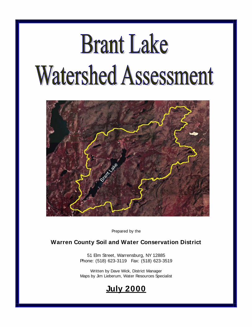
Prepared by the
Warren County Soil and Water Conservation District
51 Elm Street, Warrensburg, NY 12885 Phone: (518) 623-3119 Fax: (518) 623-3519
Written by Dave Wick, District Manager
Maps by Jim Lieberum, Water Resources Specialist
July 2000
Acknowledgements
The Warren County Soil & Water Conservation District would like to thank the following people for their cooperation and efforts on behalf of this watershed assessment:
Ralph Bentley, Supervisor, Town of Horicon
Doug Paton, President, Brant Lake Association Larry Eichler, Darrin Freshwater Institute
Sarah Frankenfeld, Warren County GIS Coordinator
Table of Contents
Introduction 1 Lake Characteristics and Stream Hydrology 2
Overview 2 Lake Water Quality 2 Brant Lake Tributaries 3 Aquatic Plants in Brant Lake 4
Soils in the Watershed 4 Land Use in the Watershed 5 Land Use Considerations on Water Quality 7
Septic Systems 8 Soil Erosion in the Watershed 8 Lawn Care and Fertilizer Use 8 Road Runoff 9
Recommendations to Protect the Quality of Brant Lake 10
General Recommendations 11 Nuisance Aquatic Plant Recommendations 11 Water Quality Recommendations 12
Stormwater 12 Septic Systems 12 Lawn Care/Fertilizers 12
Summary and Conclusions 13
Table of Maps
Map 1: Watershed Location (page 1) Map 2: Bathymetry (underwater topography) of Brant Lake (page 2) Map 3: Subwatersheds of Brant Lake (page 3) Map 4: Land Use in the Watershed (page 6) Map 5: Digital Elevation Image Map of Brant Lake Watershed (page 7) Map 6: Roads and Drainage in the Watershed (page 9)
i

Introduction
Brant Lake is the largest lake wholly contained within Warren County (approximately 1376 surface acres), located in the Town of Horicon. The Brant Lake Association has recognized a need to understand the current condition of the lake and surrounding watershed, so that they might be better equipped to protect and improve it for the future. A component of this effort was to complete an assessment of potential and existing nonpoint sources of pollution and nutrients into Brant Lake, in order to find practical means to minimize these inputs. Nonpoint source pollution is defined as any pollutant which enters a waterbody that does not come directly out of a point source, such as a pipe. Examples of nonpoint source pollution include runoff from fertilized lawns, failing septic systems, agricultural runoff, and runoff from roads and other asphalt surfaces which may have gas and oil on them. The Warren County Soil and Water Conservation District in conjunction with the Brant Lake Association has conducted a watershed wide assessment of potential and existing sources of these pollutants entering Brant Lake, and is undertaking an effort to educate the lakeside residents about failing septic systems, lake management, and other water quality related issues. This assessment is part of a larger project which is intended to raise the awareness of water quality issues on Brant Lake, and to determine the existing condition of the lake and its surrounding watershed. This project was funded through small grants from the Rural New York Grant Program and the NYS Department of Environmental Conservation. Other components of this overall effort include an aquatic plant survey conducted by the Darrin Freshwater Institute (a separate document available through the Warren County Soil and Water Conservation District (623-3119) or the Brant Lake Association), and an ongoing water sampling program being undertaken by the Brant Lake Association. These efforts are intended to give the Lake Association and the Town of Horicon a better view into the condition of the lake, and to provide insight into issues that may be negatively impacting Brant Lake.
Map 1: Watershed Location
The following report is a brief review of the findings related to an assessment of the land use conditions within the watershed, and it includes specific recommendations for improvement projects and educational efforts which could be undertaken to protect and improve the lake.
1

Lake Characteristics and Stream Hydrology
Overview Brant Lake is located in Warren County, in the Upper Hudson River watershed drainage. Being approximately 5.2 miles long, it is the largest lake which is entirely contained within Warren County. The lake itself is encompassed within the Town of Horicon, but its 25,547 acre watershed extends into the Town of Hague and even a very small portion of the northern part of the watershed is in Essex County. The maximum depth of Brant Lake is 65 feet, with an average lake depth of 30 feet. The volume of Brant Lake is approximately 41,280 acre-feet (acre foot equals the amount of water which would cover an acre to the depth of one foot). With this large volume of water, the hydraulic retention time within the lake is approximately one year. In other words, it takes about one year for the lake to flush itself out. Lake Water Quality In 1987 Brant Lake was admitted into the NYS Citizens Statewide Lake ensuing five years. The purpose of this program is to obtain some relatwater quality for a five year period, in an effort to determine any problequality. In this program, volunteers from the lake association collected samples, offered them to NYS DEC for analysis, and collated the data via the five annual CSLAP reports. Summary results of this sampling period show the lake was in good health, with no obvious water quality problems detected. The water clarity during the sampling period remained consistently high (4.3 m to 6.0 m), which is very good for recreational activities. The nutrient levels (including phosphorus and nitrogen) were fairly low, and the dissolved oxygen data serves to confirm that Brant Lake was a typical, fairly unproductive Adirondack lake with reduced risk of algae and unwanted organic matter for that timeframe. After the CSLAP program ended in 1991, the lake association did some interim sampling to keep a good record of water quality issues. In the summer of 1994, volunteers took 34 bacteria samples along the shoreline and six surface chemical test sites from mid-lake submittintotal and fecal coliform amounts were at very low levels, well below the
Brant Lake, looking
2
Map 2: Brant Lake bathymetry (water depths)
Assessment Program (CSLAP) for the ively general information on the lake’s ms or negative trends in the lake’s water
g these to the DFWI for analysis. Both the maximum standards as set by NYS.
northeast from the public boat launch
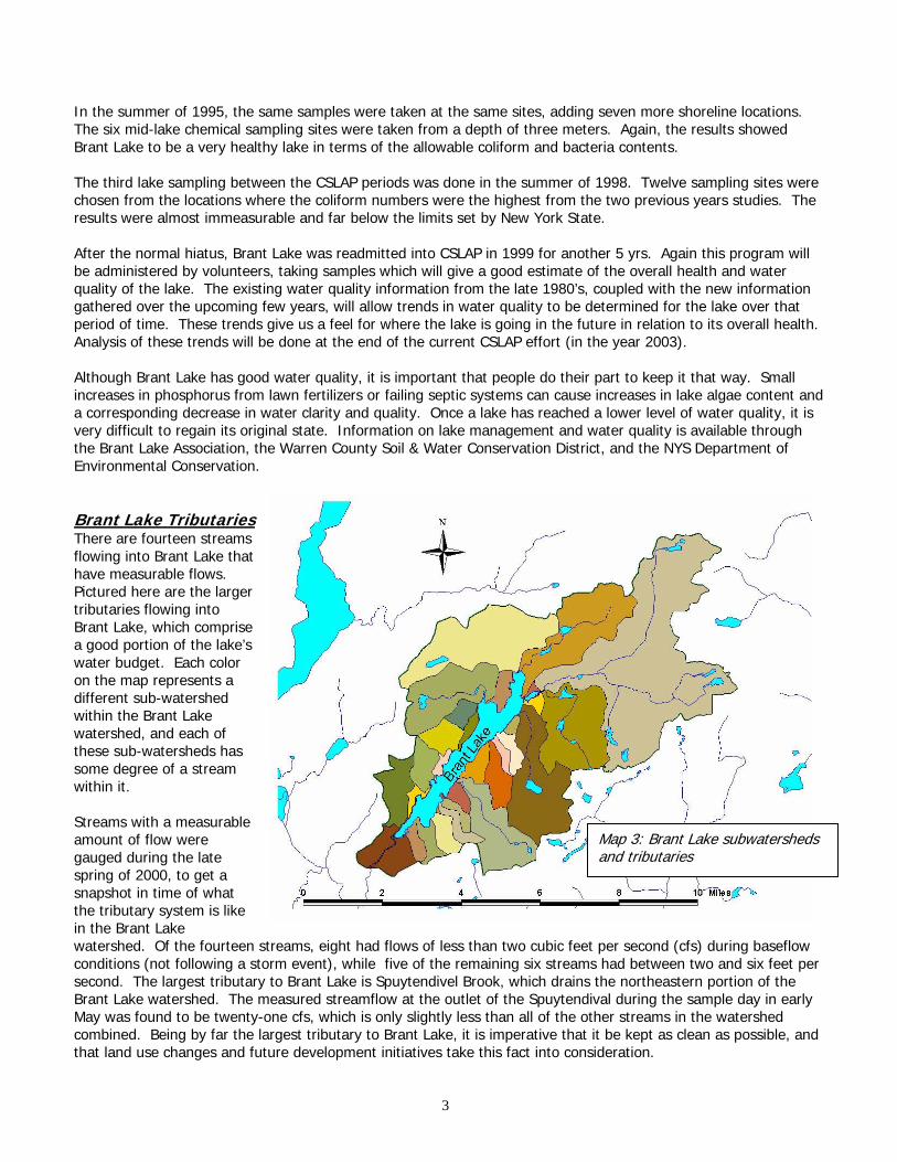
In the summer of 1995, the same samples were taken at the same sites, adding seven more shoreline locations. The six mid-lake chemical sampling sites were taken from a depth of three meters. Again, the results showed Brant Lake to be a very healthy lake in terms of the allowable coliform and bacteria contents. The third lake sampling between the CSLAP periods was done in the summer of 1998. Twelve sampling sites were chosen from the locations where the coliform numbers were the highest from the two previous years studies. The results were almost immeasurable and far below the limits set by New York State. After the normal hiatus, Brant Lake was readmitted into CSLAP in 1999 for another 5 yrs. Again this program will be administered by volunteers, taking samples which will give a good estimate of the overall health and water quality of the lake. The existing water quality information from the late 1980’s, coupled with the new information gathered over the upcoming few years, will allow trends in water quality to be determined for the lake over that period of time. These trends give us a feel for where the lake is going in the future in relation to its overall health. Analysis of these trends will be done at the end of the current CSLAP effort (in the year 2003). Although Brant Lake has good water quality, it is important that people do their part to keep it that way. Small increases in phosphorus from lawn fertilizers or failing septic systems can cause increases in lake algae content and a corresponding decrease in water clarity and quality. Once a lake has reached a lower level of water quality, it is very difficult to regain its original state. Information on lake management and water quality is available through the Brant Lake Association, the Warren County Soil & Water Conservation District, and the NYS Department of Environmental Conservation. Brant Lake TributariesThere are fourteen streams flowing into Brant Lake that have measurable flows. Pictured here are the larger tributaries flowing into Brant Lake, which comprise a good portion of the lake’s water budget. Each color on the map represents a different sub-watershed within the Brant Lake watershed, and each of these sub-watersheds has some degree of a stream within it. Streams with a measurable amount of flow were gauged during the late spring of 2000, to get a snapshot in time of what the tributary system is like in the Brant Lake watershed. Of the fourteen streams, eight had flows of less than two cubic feet per second (cfs) during baseflow conditions (not following a storm event), while five of the remaining six streams had between two and six feet per second. The largest tributary to Brant Lake is Spuytendivel Brook, which drains the northeastern portion of the Brant Lake watershed. The measured streamflow at the outlet of the Spuytendival during the sample day in early May was found to be twenty-one cfs, which is only slightly less than all of the other streams in the watershed combined. Being by far the largest tributary to Brant Lake, it is imperative that it be kept as clean as possible, and that land use changes and future development initiatives take this fact into consideration.
Map 3: Brant Lake subwate sheds and tributaries
r
3

Aquatic Plants in Brant Lake In July of 1990 and again in November of 1999, the Darrin Freshwater Institute (DFI) was commissioned to complete a comprehensive study of the aquatic plant community in Brant Lake, primarily focusing on the status of Eurasian Watermilfoil within the lake. This invasive plant species which grows quickly and aggressively in the right lake environment, potentially causing problems with recreational activities and ecosystem function. The 1999 DFI report documents fourteen areas of the lake supporting dense growth, with the majority occurring in the northern third of the lake. Five of the areas of dense growth were in a large bay at the northern end of the lake which includes the largest single area at the northwestern end of the bay. However, most of the littoral zone (nearshore area) of the lake supports scattered populations of Eurasian watermilfoil to some degree. This plant is most likely to take hold in areas of suitable bottom sediments (not rocky or sandy), but has the potential to root in almost any area of a lake. At the current time, dense growth of Eurasian watermilfoil covers approximately 1.3 acres of the littoral zone of Brant Lake (0.2%). Although this seems to be only a moderate amount, it must be realized that this plant expands its coverage relatively quickly. To manage this nuisance plant within Brant Lake, the Darrin Freshwater Institute puts forward recommendations for future activities. These milfoil control recommendations are included in the “Recommendations” section of this document. Each Eurasian Watermilfoil management technique has positive and negative aspects, and a plan should be developed with the key stakeholders such as the Town of Horicon and the Brant Lake Association. Aquatic plant management is a long term strategy, and it is important to fully review the possibilities and realities before plant management activities begin.
Eurasian Watermilfoil
Soils in the Watershed What benefit is it to know what the soils are within a watershed or along a shoreline? This question is often asked by lakeshore residents and communities when evaluating water quality potential impacts. The soils lay the framework that all land uses are based upon, and they have a direct correlation to what type of land uses may be suited to a particular location. Very sandy soils may pose serious problems with siting a septic system for a house, whereas soils with a high clay content may cause difficulties with house foundations and construction. This section briefly evaluates the soils within the nearshore area of Brant Lake to summarize what some of the potential concerns might be with land uses and water quality within the lake. Please note that this is only a brief summary of the soil conditions, and much more detailed information and maps are available in the Warren County Soil Survey available through the Warren County Soil & Water Conservation District. The Brant Lake watershed has over 30 different soil types, consisting of primarily glacial till soils such as Bice, Stowe, and Woodstock, which are found in forested and mountainous areas like this one. Near the shoreline area there are some glacial outwash sands such as Hinckley and Plainfield. This area, within 400 feet of the shoreline is considered the most critical area when it comes to erosion problems and potential water pollution, so it will be on this area that this assessment concentrates. The soil types within the shoreline area of the Brant Lake consists mostly of Bice, Plainfield, and Hinckley soils. About 50% of this area is Bice soil. BdE and BeE soil types are relatively steep and present severe limitations to development and many other uses because the slope is between 15 and 45%. Bice soil types do have moderate limitations for septic tanks due to slope and slow percolation of effluent, which may pose concern for lakefront development. They also exhibit moderate limitations for shallow excavations, dwellings with and without basements, small commercial buildings, and roads and streets. It’s improbable that you’ll find sand and gravel in
4

these soils; however, they are rated “fair” when used for road material. It’s worth noting that the depth to bedrock and the high water table are not a concern in regard to development in these deep, well drained soils. About 35% of the shoreline area consists of Plainfield loamy sand (20%) and Hinckley cobbly sandy loam soils [15%], which are deep, well to excessively drained, sandy soils. These soil types present difficulties with location and functioning of septic systems because they act as poor filters of septic effluent. This is primarily due to the short contact time that the septic effluent has with soil particles because of the rapid flow of liquid through the sandy soil material. Therefore, the characteristics of Plainfield and Hinckley soils present some limitations to residential and commercial development in the watershed. A significant amount of the shoreline area – about 9% - consists of either organic soils, which preclude development or soils with high water tables close to the soil surface, which severely restrict development. There are “muck” type soils in some areas which are deep organic soils which simply not conducive to development. Some of these soils are generally flooded and unlikely to ever be developed. Both Lyme and Wareham soils exhibit these conditions and have a high water table that is at a depth of 1.5 feet up to the soil surface. Therefore the high water table presents severe limitations for septic systems, dwellings with or without basements, shallow excavations, small commercial buildings, and roads and streets. You may be able to build on these soils; however, you will have to go through the expense of alternative septic systems located somewhere in an adjacent soil type and having to engineering ways to contend with the seasonal high water table – raised buildings, drainage, etc. Rock outcrops comprise about 4% of the Brant Lake shoreline area. These situations present severe limitations because they are obviously shallow to bedrock. Although difficult, there are many ways to engineer “around” slope and rock outcrop limitations including but not limited to buildings on braces/stilts; walls/terraces of concrete, wood, or rock; steep driveways; and raised foundations. From a soils standpoint about 75% of the Brant Lake shoreline area can be considered developable. Of that percentage, 35% has soils that have severe limitations for development as described above. The remaining 40%, primarily Bice soils, only has moderate limitations. Almost all of this developable shoreline area is currently developed as residential, recreational (including camps), or commercial/institutional uses (see Land Use section below). Only a few vacant fields/open areas exist that actually could be developed, based on natural resource limitations. At that point, land ownership, financial resources, and social considerations become factors that apply to weather or not an area of land actually is developed. Whatever the soil conditions, whenever modifying an existing land use for development it is a good practice to control for erosion with a good site plan and follow-up. Erosion of soil into Brant Lake can cause problems with increased algae and weed production, both of which negatively impact the quality of the lake and its surrounding community. Erosion control advise and technical assistance is available at no charge from the Warren County Soil & Water Conservation District (623-3119).
Land Use in the Watershed Land use information is very important when characterizing a watershed and determining potential impacts to water quality of a lake. How developed an area is and where the development is located can play a key role in the contaminant loading to a waterbody. To determine the land uses within the Brant Lake watershed, a geographic information system (GIS) was employed to develop a coverage related to the various land uses. Initially the watershed was delineated on USGS 7.5 minute topographic maps. Using 1990 aerial photos as well as 1995 digital aerial photos, land uses were identified and referenced back to the topographic maps.
5

The strong majority of the Brant Lake watershed is forested, however there are seven general land uses within the watershed overall. The total acreage for the land area of Brant Lake’s watershed is 25,547 acres. The following is a breakdown of the land uses within the watershed:
Map 4: Current Land uses within the Brant Lake watershed.
For the purposes of this assessment, the following seven (7) land use categories were
used: Forest: There are acres of forest in the watershed. (87% of watershed area). Residential: Mostly along the shoreline. Consists primarily of camps and second homes. Includes small clusters of cabins for rent and small campgrounds. (3.6% of watershed area). Agricultural:
Brant Lake Farm -- was a large beef cattle farm, now horses Point of Pines Farm – horse farm Marshwiggle Farm – Ed Orr and Tish Edwards’ organic vegetable farm
(1% of watershed area). Commercial/Institutional:
Mostly in area around Mill Pond. Includes a boat marina, gas station/car garages, Daby’s General Store, PO, Library, Churches, Historical Society, Cemetery, etc. (0.2% of watershed area).
Recreational/Camps:
Brant Lake Camp Camp Read BSA Reservation Point of Pines Camp Pilgrim Camp
(0.5% of watershed area).
6
Open/Vacant Land: Only a few spots left here and there – often connected with a residential property. (0.7% of watershed area). Water:
Lakes and ponds within the watershed. (6.9% of watershed area)
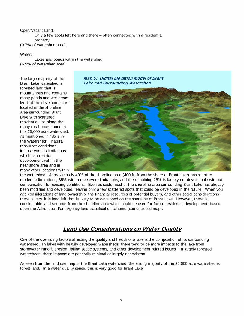
Map 5: Digital Elevation Model of Brant Lake and Surrounding Watershed
The large majority of the Brant Lake watershed is forested land that is mountainous and contains many ponds and wet areas. Most of the development is located in the shoreline area surrounding Brant Lake with scattered residential use along the many rural roads found in this 25,000 acre watershed. As mentioned in “Soils in the Watershed”, natural resources conditions impose various limitations which can restrict development within the near shore area and in many other locations within the watershed. Approximately 40% of the shoreline area (400 ft. from the shore of Brant Lake) has slight to moderate limitations, 35% with more severe limitations, and the remaining 25% is largely not developable without compensation for existing conditions. Even as such, most of the shoreline area surrounding Brant Lake has already been modified and developed, leaving only a few scattered spots that could be developed in the future. When you add considerations of land ownership, the financial resources of potential buyers, and other social considerations there is very little land left that is likely to be developed on the shoreline of Brant Lake. However, there is considerable land set back from the shoreline area which could be used for future residential development, based upon the Adirondack Park Agency land classification scheme (see enclosed map).
Land Use Considerations on Water Quality One of the overriding factors affecting the quality and health of a lake is the composition of its surrounding watershed. In lakes with heavily developed watersheds, there tend to be more impacts to the lake from stormwater runoff, erosion, failing septic systems, and other development related issues. In largely forested watersheds, these impacts are generally minimal or largely nonexistent. As seen from the land use map of the Brant Lake watershed, the strong majority of the 25,000 acre watershed is forest land. In a water quality sense, this is very good for Brant Lake.
7

Septic Systems On-site wastewater treatment systems (septic systems), when properly designed, installed and maintained, have no adverse impacts on water quality or public health. When one of these three criteria fall short, there may be impacts to water quality of a nearby lake. In addition, there may be health concerns related to improperly treated septic effluent, as bacteria may reach the groundwater and may end up in a private or public well. Effluent from a standard septic system flows out of an absorption trench or a seepage pit and into the ground where the soil provides the final treatment and uptake of nutrients and pollutants. If the system is very old or is not properly maintained, it has a good chance of failing and not providing the treatment that it should. This is a major concern especially on lakes where lot sizes are small and many of the structures on these lots are older. Brant Lake has numerous year-round residences and camps upon its shoreline. Many of these residences were built in the mid 1950’s and 1960’s, and less concern was given to the potential development impacts upon the water quality of the lake than is today. The building lot sizes around the northeastern side of Brant Lake are relatively small, with camps and small homes built close to the shoreline. As many of these structures were seasonal camps, the septic systems were designed as such and generally consist of small septic tanks and seepage pits. There is little room on most of these lots for a standard leach field type system, and therefore very few are likely to exist. The issue that arises is the level of treatment that the septic effluent receives may not be as high as on a larger lot with a leach field system because the effluent is localized in a seepage pit. In addition, many of the residents on the lake do not know exactly what type of septic system is located on the property. This is a concern because if they do not know what type of system is on the property, then there is little likelihood that this system has been properly maintained. Although a qualitative survey of the septic system situation along the Brant Lake shoreline would suggest some concern, currently there is no evidence of negative impacts from septic systems on Brant Lake. There have been no reported cases of illness due to polluted well water from residences along the shoreline, and it is very difficult to determine if the aquatic weed growth is being accelerated by nutrients from failing septic systems. It would be beneficial to quantitatively determine any existing impacts from septic systems, but to date no comprehensive study of the water chemistry along the shoreline has been conducted to discover these impacts. Soil Erosion in the Watershed Eroding soils are a cause for concern when they are carried to a nearby waterbody, as they can carry large amounts of phosphorus and nitrogen with them which aid in the growth of algae and aquatic weeds. A complete roadside survey of existing bare banks, ditches and other potential erosion sites within the watershed revealed no considerable concern for soil erosion at the present time. However, new construction on or near the lakeshore, if improperly undertaken, can be a substantial source of eroding soil at any time in the future. Also, road ditch maintenance activities undertaken by local highway departments, if improperly seeded and mulched, can be a direct source of erosion and sedimentation to a nearby waterbody. It is very important to keep soil in place during construction activities by proper planning and installation of erosion control devices such as silt fence and hay bales. Staff from the Warren County Soil and Water Conservation District are available to landowners at no charge to assist with recommendations for erosion control from new development. Lawn Care and Fertilizer Use Lawn care activities are a concern along the shoreline of lakes because they are potential non-point sources of pollution either through the excessive use of lawn care products (fertilizers and pesticides) or by disposal of lawn clippings and other debris close to the water. By definition, fertilizers are created to provide nutrients to improve the growth of lawns and other vegetation. If a landowner puts down more fertilizer than a plant can uptake, the remaining fertilizer may run off into the nearest waterbody. If this fertilizer reaches the waterbody, it acts in exactly the same way as it does on a lawn. The nutrients in fertilizer allow for much more aggressive growth of aquatic plants and algae, which may cause problems with the water quality and recreational opportunities for the
8

lake. With such a large percentage of the Brant Lake shoreline area in residential development, the use of fertilizers on properties adjacent to the lake is a very real concern for water quality impacts. Lawns in and of themselves are not a concern, as the grasses in a lawn actually slow the flow of runoff and allow for infiltration of stormwater runoff. Where it does become a concern is when landowners over-fertilize in an attempt to create the perfect lawn. The degree to which the shoreline landowners apply fertilizers and pesticides to their lawns is not known on Brant Lake. As there are no regulations or statutes regarding lawn care, there is no good way to control for the application of these chemicals to shoreline areas. The best means of minimizing the impacts from over-fertilization from these landowners is through education. Suggestion for educational efforts are outlined in the “Recommendations” section that follows. Road Runoff
Map 6: Stormwater drop inlet locations: Route 8, Brant Lake
One of the primary impacts to lake quality and health of the aquatic ecosystem is the quality of the runoff which enters the lake. As land gets developed and roads are constructed, the flow patterns of rain runoff get altered in these areas. In
most cases, runoff which once infiltrated into the ground before development now runs off into drainage ditches and storm drains. The eventual outlet of these storm drains and ditches is the lowest point in the area, most times being the lake itself. The result is a larger amount of surface runoff going directly into the lake, and in many cases the water quality of this runoff is generally less than it would have been under pristine conditions. As this runoff flows across blacktop and other impervious surfaces, it picks up contaminants on the road such as salt and sand from winter de-icing operations, oil
and other chemicals, metals, and possibly fecal coliform bacteria from animal wastes. These pollutants are conveyed into the lake via the constructed drainage system, i.e. the stormwater inlets and pipes and roadside ditches. Brant Lake, like most other developed lakes, has this roadside drainage network surrounding the lake. The major road corridor along the shoreline is NYS Route 8, which runs along the southeast shore. This NYS Department of
9

Transportation two-lane highway lies generally within fifty yards of the shoreline and has 36 stormwater runoff drop inlets which enter the lake (see maps 6&7). Each of these inlet structures collects the flow from a section of road surface and outlets it into a drainage way and then into the lake. Depending on the proximity to the lake, some of these inlets are direct discharges to the lake while others have a thirty to one hundred yard run through a drainage ditch before entering the lake. The fact that there are thirty six drop inlets which directly outlet into Brant Lake is not in itself indicative of a problem. Stormwater problems are related to what contaminants are picked up by the runoff which enters the lake. In the case of Route 8, there is no commercial development such as gas stations, convenient marts, large parking lots and other such things which might harbor harmful substances on their surfaces. This is a definite plus in terms of water quality. In essence, the only contaminants coming from this highway should be winter road de-icing products (salt and sand), possibly some oil and grease and anti-freeze from leaking automobiles, fecal coliform bacteria from animals, and thermal impacts from hot road surfaces. To date, there has been no comprehensive study of the water quality of the stormwater coming out of these culverts, and therefore no quantitative measure can be given herein. However, the above mentioned pollutants are likely present on this roadway to some degree based on visual inspection, mandatory roadway maintenance (de-icing activities), and common sense. To begin mitigation of some of the stormwater impacts to Brant Lake, each of the drop inlets on Route 8 has been categorized herein in terms of its potential impact to the lake (high, moderate and low priority). The higher priority inlets are ones which have a larger drainage area behind them and are closer to the lake shore. The lower priority inlets have small drainage areas and are farther from the shore. To eliminate some of these stormwater concerns to Brant Lake, these drop inlet (pass through) structures could be modified to infiltrate much of this stormwater and capture sediment from the runoff (see recommendations below). A second roadway of significance around Brant Lake is Palisades Road on the Northeast shore, which is maintained by Warren County. There is no subsurface drainage system to speak of on Palisades Road, and runoff from storm events just flows off into the roadside grass or woods in general. This being the case, there are few stormwater quality concerns from Palisades Road which need addressing. There are, however, sections of this road which are directly adjacent to the shoreline which runoff directly into the lake as sheetflow. Since there is no real concentrated flow on these sections, there is probably little concern in terms of water quality impacts. Overall, the impacts to Brant Lake from road runoff are seen as moderate, and can be minimized through some roadside drainage improvements. These drainage suggestions are listed in the “Recommendations” section below.
Recommendations to Protect the Quality of Brant Lake Currently, the Brant Lake watershed appears to be in very good condition related to the level of pollutants which enter the lake and in good condition regarding the amount of nuisance aquatic weeds within the lake. With a relatively low level of development within the watershed, no major commercial enterprises in the near-shore area, and generally well maintained homes on the shoreline, pollutant sources are largely minimized. However, there are situations that exist within the watershed which may have negative impacts on the water quality and overall health of Brant Lake. It is these situations which the following recommendations have been put forth to improve upon. The following recommendations are intended to provide specific, cost effective means to protect the quality of the water of Brant Lake. They entail both educational efforts and on-the-ground tasks to be undertaken to help ensure the long term water quality of the lake. These recommendations do not go into issues regarding zoning regulations around the lake, nor do they look at statutory changes to the Town of Horicon or Town of Hague
10

codes. They are primarily geared towards local stewardship of the lake and projects that can be done locally to protect this lake. The Brant Lake Association will likely be the catalyst for much of the protection and improvement efforts to be undertaken for Brant Lake, with assistance from the Town of Horicon, the Warren County Soil and Water Conservation District, and many others. By increasing the awareness of the issues on Brant Lake, the lake association can begin to achieve support from all landowners on the lake and undertake many of the improvements to protect it for the future. General Recommendations 1. Maintain an active lake association to act as a hub to address issues of concern on Brant Lake, and to provide
information relating to issues on Brant Lake to all shoreline and association residents. The ongoing activity and interest within this association is paramount to the continued long term health of Brant Lake.
2. Give an annual presentation to the Horicon Town Board relating to work accomplished on Brant Lake and the
status of water quality, nuisance aquatic weeds, and other related issues. 3. Maintain status in the Citizens Statewide Lake Assessment Program, which is a voluntary lake water quality
assessment program administered by the NYS DEC. As this is a five year on / five year off / five year on program, determine a way to fund those middle five years so that a continuous record of water quality data will be created for the lake.
4. Conduct frequent roadside surveys of potential soil erosion sites, on road ditches and banks and new
development sites. Contact the Warren County Soil and Water Conservation District if any sites of significance are found, so that technical assistance may be given to correct the situation.
5. Have copies of this document and the Darrin Freshwater Institute’s report on nuisance aquatic plants (or
subsections of these) sent to all residences along the lake with a cover letter encouraging them to get involved with their lake association if they are not already.
Nuisance Aquatic Plant Recommendations 1. The Brant Lake Association should form an aquatic plant management committee to review the issue and take
action to manage the situation. 2. Scattered populations of Eurasian Watermilfoil could be managed via hand harvesting, at an approximate cost
of $30,000. 3. Dense growth areas could be managed with a combination of benthic barrier and suction harvesting. At 1.3
acres of dense growth, the cost of benthic barrier would be approximately $30,000, and the cost of suction harvesting would be similar to this.
4. The Brant Lake Association could consider the use of an aquatic herbicide such as fluridone (SONAR™), which
have proven to be effective in other lakes, but is costly. Whole lake treatment would cost approximately $200,000, but spot treatments of particular areas may be considerably less.
5. The Brant Lake Association should post all boat access areas with posters urging boaters to clean their boats
prior to launching in the lake. This would help prevent the spread of milfoil from Brant Lake as well as further introductions into Brant Lake.
11

Water Quality Recommendations Stormwater 1. Work with NYS DOT on designing and installing stormwater improvement structures for the three identified
high priority drop inlet sites. These drop inlet structures should be retrofitted or replaced with structures which have the capacity to act as catch basins/infiltrators to infiltrate the first flush of stormwater and remove road sand and debris from road runoff before it reaches the lake. These structures (pre-cast dry wells) have been proven to be effective at infiltrating stormwater in sandier soils such as are present on the southeast shore of Brant Lake.
2. Review the drop inlets listed as “moderate impact” and put together a long range plan for retrofitting these
structures with infiltrators or other stormwater improvement structures. 3. Develop a maintenance schedule with NYS DOT for cleanout of these infiltrators to ensure that they still have
the capacity to work effectively. Septic Systems 1. Contact Adirondack Community College professor Holly Ahern to determine the feasibility of the college in
undertaking a water quality sampling study to determine the degree to which septic systems are failing along the lakeshore. Professor Ahern and her students conducted a comprehensive study on Glen Lake in 1997-1998 on this topic, and may have interest and availability of doing it for Brant Lake.
2. Contact John Miller, past president of the NYS Federation of Lake Associations (FOLA) to get the Brant Lake
Association involved with their volunteer septic monitoring program. This program works on the Lake Association level through cooperation with local landowners to dye test individual septics to check for failures. The number for FOLA is (800) 796-3652.
3. Conduct a voluntary survey of lakeshore landowners to obtain information regarding individual septic systems
regarding their age, size, and maintenance schedule. This will give the lake association a clear idea of the necessity of upgrading or maintaining systems around the lake. Since this is always a sensitive issue among homeowners, the association should network with their friends around the lake to get as much cooperation as possible.
4. Create a water quality section in the Brant Lake Association’s newsletter which would feature articles on such
topics as the impacts to water quality from failing septic systems, septic system maintenance tips, who to call if you have a septic problem, and any others related to this topic.
5. Contact a reputable septic system pumper to work out a bulk deal whereby many landowners get their septic
tanks pumped out at a reduced cost. Network with the landowners on the lake to generate interest in this. If it works out, attempt to make this a three year program whereby these landowners know that this deal will come around only once every three years and to get involved.
6. Sponsor an annual water quality workshop and invite interesting speakers to discuss the issues surrounding
Brant Lake. A general rule: feed them and they will come… Lawn Care/Fertilizers 1. Through the Association’s newsletter, educate watershed residents about the issues related to over-fertilization
of lawns and gardens and the impacts to water quality on their lake from these activities.
12

2. Contact a local landscape nursery to determine the most environmentally friendly (low phosphorus) fertilizer which would be recommended for lawns on a shoreline. Discourage fertilizer use on any lawn which is adjacent to the lake shore and is sloped towards the lake.
3. Contact Cornell Cooperative Extension to obtain soil sample bags for use by landowners to determine the
nutrient needs of their lawns. To increase participation, create a “lawn care program” where the cost of analysis ($17) is cost shared or paid for by the Association.
Summary and Conclusions Lakes are one of our most precious natural resources. As population increases and development pressure expands its force on these resources, it is imperative that we strive to maintain these natural systems in a state where it can continue to support the aquatic ecosystem that it has developed. One key component in this effort is watershed management. By understanding the lands surrounding a lake, we can begin to understand how lakes respond to man’s influence. Over the past year, a watershed planning effort has taken place on Brant Lake to determine the current health of the lake and its surrounding watershed. Local citizens, the Brant Lake Association members, the local Soil and Water Conservation District, municipal officials and other parties joined together in this undertaking, utilizing their diverse backgrounds and expertise in this endeavor. A close look was taken at the current and historical water quality of Brant Lake, the status of nuisance aquatic plants in the lake, and the condition of the land surrounding the lake. By reviewing all of this information, we get a feel for the health of the lake in its current state. Perhaps more importantly however, is that this information gives us a perspective about where the lake is headed in the near future in relation to these issues. Through a volunteer water quality monitoring effort, the Brant Lake Association collected information on various parameters including lake clarity, algae content, phosphorus, and others since late 1987. This information has revealed that Brant Lake is indeed a very healthy lake with only moderate algae and clarity concerns. Water clarity is generally in the four to six meter range, and algae blooms are rare. Phosphorus and coliform bacteria levels are well within acceptable parameters for a healthy lake, and no immediate concerns have been detected through this program. With proper land use management, it is likely that the lake will continue to exhibit good overall health.
A primary concern in lake management today is nuisance aquatic plants. One specific plant is of considerable concern for residents and visitors to Brant Lake; Eurasian Watermilfoil (milfoil). Milfoil is an aggressive plant which grows quickly and abundantly, with the potential to create large dense beds in water depths of up to twenty feet in good conditions. Milfoil does exist in Brant Lake, but it was not known to what degree. To determine this, the Darrin Freshwater Institute was commissioned in the summer of 1999 to undertake a survey of the lake and report on current conditions. Their findings indicate that there are approximately 1.3 acres of dense milfoil in Brant Lake, and many scattered areas of sparse growth throughout the lake. This report was compared to a 1989 milfoil report, and it is noted that milfoil has expanded its range and density within the lake. Recommendations for management include hand harvesting the scattered areas, and looking into other possibilities such as benthic barriers for managing the dense beds. Copies of the complete report are available through the Brant Lake Association or the Warren County Soil and Water Conservation District. The third component of this study was an evaluation of the watershed lands surrounding Brant Lake. The quality of a lake’s water and ecosystem are largely a result of the lands surrounding the lake. As development increases, many times there becomes a corresponding decrease in water quality due to road runoff, construction practices, and other related items. The Brant Lake watershed currently has only a small amount of development within its boundaries, which is a positive for the lake. However, most of the development in the watershed is adjacent to the shoreline, which creates a higher potential for impacts to the lake.
13

Road runoff in intensely developed areas can be a major contributor to lake water quality decline, if this runoff picks up contaminants which lie on road surfaces. To determine any potential impacts to Brant Lake, a watershed wide study of the roads and highways was conducted. Route 8 on the southeast side of Brant Lake is of moderate concern, and areas were identified for stormwater drainage retrofitting. Working with the NYS Department of Transportation, these sites can be improved to a state where stormwater impacts to Brant Lake are minimized. Another potential water quality concern for lakes is failing on-site septic systems. It is difficult to determine whether one of these private wastewater treatment systems is working properly, but through nearshore water sampling some of these sites can be detected. A good volunteer program exists through the NYS Federation of Lake Associations regarding volunteer testing of private systems, with a main component being homeowner education. To minimize the impacts of failing septic systems on Brant Lake, a strong educational effort for shoreline residents is strongly recommended regarding the necessary maintenance of their systems and other potential water quality impacts such as excessive lawn fertilizing. Brant Lake as a waterbody will be around for many hundreds or thousands of years. Within only a few short decades, development around Brant Lake has begun to a point where the entire shoreline is largely developed. Poor management of these lands can strongly impact the water quality and aquatic ecosystem of Brant Lake, to a point whereby it can never regain its original state. It is incumbent upon the residents and visitors of this precious resource to be vigilant in protecting this lake for the future. We have the potential to pollute this beautiful lake but we also have the potential to keep it in its current state. With a strong stewardship ethic towards Brant Lake, it will continue to be a natural resource that our generation and future generations can greatly enjoy.
14