Embed Size (px)
Citation preview

Planning Committee
Unrestricted Report
ITEM NO: 08 Application No.
20/00155/FUL Ward:
Binfield With Warfield Date Registered:
28 February 2020 Target Decision Date:
29 May 2020 Site Address: Wyevale Garden Centre Forest Road Binfield
Bracknell Berkshire RG42 4HA Proposal: Erection of 20 no. dwellings with associated landscaping, open
space and car parking following the demolition of existing buildings.
Applicant: Spitfire Bespoke Homes Ltd Agent: Miss Rosalind Brace Case Officer: Jo Male, 01344 352000
Site Location Plan (for identification purposes only, not to scale)
© Crown Copyright. All rights reserved. Bracknell Forest Borough Council 100019488 2004

Planning Committee
OFFICER REPORT
1. SUMMARY 1.1 The application proposes the erection of 20no. dwellings following the demolition
of the existing commercial buildings which relate to the site’s lawful use as a garden centre.
1.2 It proposes a reduced scheme in comparison to an earlier application (ref:
18/01168/FUL) which proposed the erection of 29 dwellings on the site. This application was refused permission under delegated powers in May 2019. An appeal against this refusal is due to be heard by way of Informal Hearing. This was initially scheduled for May 2020 however has been postponed due to the current Coronavirus situation.
1.3 The site is located within the countryside beyond any settlement boundary. Whilst
new dwellings within the countryside results in a conflict with the development plan, the application site comprises previously developed land for the purposes of the NPPF and the existing development has an impact upon the character of the countryside. This is a material consideration in the determination of the current application.
1.4 The previous proposal for 29 units was considered to result in a form of
development that would have a materially greater impact upon the character of the countryside than the existing development. However, the revised scheme significantly reduces the number of units proposed, allowing revisions to the layout that results in a form of development which is not considered to have a materially greater impact on the character and appearance of the countryside than the existing development.
1.5 The application would provide 20no. dwellings although none of these would be
affordable as the Vacant Building Credit is claimed. It also offers some economic and environmental benefits as set out in the following report. On balance, Officers are of the opinion that the development’s conflict with the development plan is outweighed by other material considerations and therefore approval is recommended.
RECOMMENDATION
Planning permission be granted subject to the completion of a s106 Agreement and conditions in Section 11 of this report.
2. REASON FOR REPORTING APPLICATION TO COMMITTEE 2.1 The application has been reported to the Planning Committee as it represents a
departure from the development plan. 3. PLANNING STATUS AND SITE DESCRIPTION
PLANNING STATUS
Outside Settlement boundary within Countryside

Planning Committee
TPO No. 1299
Located between 5 – 7km of the Thames Basin Heaths SPA
3.1 The application site extends to approximately 1.89 hectares and is located on the
northern side of Forest Road. It is currently unoccupied, however it contains the main garden centre building which comprises a single storey metal-framed glazed structure attached to a two storey brick-built cottage, with open-sided canopies on its northern and western sides. A single storey, building previously used for aquatics sales is located in the site’s north-western corner and a lean-to building is located on its northern edge. Extensive areas of hardstanding cover much of the remainder of the site, being used for car parking on the site’s western and southern sides, plant sales to the north, and storage/servicing along its eastern edge.
3.2 The site contains a 3m high brick wall which comprises a walled-garden feature
originally associated with Binfield Manor, a Grade II listed building located on the southern side of Forest Road to the south-east of the application site. Although unlisted, this wall is considered to be a non-designated heritage asset due to the relatively good quality of its brickwork, its survival and its association with the Grade II Listed Binfield House.
3.3 A Tree Preservation Order (TPO No. 1299) protects multiple trees both within
and on the periphery of the site.
3.4 The site fronts Forest Road along its southern edge and is bordered by undeveloped land to its east, north and west. The water course known as ‘The Cut’ is located to the east of the site. Part of the eastern side of the site lies within Flood Zones 2 and 3.
3.5 The site is located approximately 5.2km from the boundary of the Thames Basin
Heaths Special Protection Area (SPA). A Local Wildlife site lies approximately 60m to the east of the site with another located on the opposite site of Forest Road.
3.6 The site is located beyond any settlement boundary within land identified as
‘countryside’ for the purposes of the development plan. 4. RELEVANT SITE HISTORY
616603 Creation of Garden Centre following demolition
of existing glass houses, involving the erection
of a single storey glasshouse (1,950 sq. m
indoor display area), formation of parking and
outdoor etc.
Approved
(05/03/1991)
01/01182/FUL Erection of single storey extension to rear of
existing shop, for display of aquatic products.
Approved
(14/02/2002)
05/00702/FUL Erection of extension to garden centre shop
(1,425 sq. m) and horticultural plant shades
(630 sq. m) and formation of new external plant
display area.
Approved
(27/01/2006)
07/00718/FUL Erection of 268 sq. m extension to garden
centre shop following the demolition of existing
Approved
(12/10/2007)

Planning Committee
converted house (216 sq. m) as a phase 2
development to scheme already approved
which will provide 1,425 sq. m of new extension
under planning permission 05/00702/FUL.
10/00010/FUL Erection of canopy for provision of car wash
facility with associated parking areas and
erection of storage shed.
Approved
(19/02/2010)
10/00471/EXT Erection of extension to garden centre shop
(1,425 sq. m) and horticultural plant shades
(630 sq. m) and formation of new external plant
display area. [Note for clarification: This
application was for an extension of the time limit
to implement an existing planning permission
05/00702/FUL]
Approved
(04/04/2011)
10/00472/EXT Erection of 268sq.m extension to garden centre
shop following demolition of existing converted
house (216sq.m) as a phase 2 development to
scheme already approved which will provide
1425sq.m of new extension under planning
permission 05/00702/FUL. [Note for
clarification: This application was for an
extension of the time limit to implement an
existing planning permission 07/00718/FUL].
Approved
(15/09/10)
10/00725/FUL Retention of timber entrance canopy and plant
shade
Approved
(4/1/11)
10/00726/FUL Section 73 application for variation of conditions
8 & 9 of planning permission 616603 to allow
the use of part of the parking area for storage of
goods and as a seating area serving the
existing cafe and extension to car park.
Condition 8 states that "no dwelling/building
shall be occupied until the vehicle parking
spaces have been marked out in accordance
with the approved drawing. The spaces shall
thereafter be kept continuously available for
parking". Condition 9 states that "the areas
shown on the approved plans as parking,
access, loading, unloading and manoeuvring
areas shall be kept clear for these purposes
and shall not be used for any storage, industrial
or business purposes"
Granted
(13/01/2011)
11/00350/FUL Application to remove condition 2 of planning
permission 10/00725/FUL. This condition
relates to the goods to be sold at the garden
centre.
Refused.
Appeal
allowed
(07/02/2012)

Planning Committee
15/00606/FUL Use of 5 no. parking spaces for hand car wash
and valeting operation including the installation
of a canopy, wash screens, and 2 no. cabins for
staff, customer waiting and storage uses.
Temporary
Permission
Granted
(26/10/2015)
16/00802/FUL Change of use and enclosure of garden centre
land to use as a dog day care centre (sui
generis), and erection of detached wooden
building to be used as part of the facility.
Granted
(12/10/2016)
19/00709/LDC Application for a Certificate of Lawfulness for
operation of site under unrestricted Use Class
A1 (Shops)
Granted
(04/11/2019)
18/01168/FUL Erection of 29no. dwellings with associated
landscaping, open space and car parking
following demolition of existing buildings
Refused.
(29/5/19).
Appeal
pending.
4.2 The application site was submitted for consideration as a potential housing site
within the emerging Local Plan (Ref: BIN 4). However, it was not identified as a
proposed allocation in the draft Local Plan that was subject to public consultation
in October – December 2019. The Local Plan process assesses the relative
merits of all submitted sites, to identify those most suitable to meet the Borough’s
housing needs over the Plan period. Failure to identify the site as a housing
allocation within the emerging Local Plan does not impact upon the consideration
of this stand-alone planning application which should be determined on its own
merits.
5. THE PROPOSAL 5.1 The proposal is for the erection of 20 residential units, following the demolition of
the existing commercial buildings, including the main garden centre building. The proposed development would be sited entirely within the confines of the existing 3m high (unlisted) wall which forms part of a walled-garden feature originally associated with Binfield Park. It would utilise the existing access into the site from Forest Road and would include the formation of associated access roads, parking, garages, car barns and soft landscaping.
5.2 The proposed dwellings would comprise 2no. pairs of semi-detached houses and
16 no. detached dwellings of the following mix: 4 no. 3 bed semi-detached houses 9 no. 3 bed detached (including link detached) houses 7 no. 4 bed detached houses. 5.3 No affordable housing is proposed as part of the development as Vacant
Buildings Credit is claimed. This issue is addressed later within Section 9 of this report.
5.4 Parking would be provided through a mix of driveways, garages and car barns.
The potential for secure cycle storage is provided within the rear garden of each dwelling.
Planning Committee
5.5 An area of public open space is provided centrally within the site. Around its perimeter, beyond the unlisted wall, a ‘leisure walk’ would be created, accessed by both existing and new openings within the wall. This would have a gated access at the front of the site and would be for private use by future residents only.
5.6 The proposed development would be set back a minimum distance of 20m from
the back of the footway to Forest Road allowing the provision of a landscaped area across the width of the site. On the eastern side of the frontage, the depth of this area would extend to 33m, incorporating land within Flood Zones 2 and 3 and providing an area for surface water attenuation.
5.7 The application has been submitted in an attempt to address the reasons for
refusal in respect of application 18/01168/FUL. This application was refused on 5 grounds, however those relating to drainage and infrastructure requirements have been addressed prior to the appeal, leaving a single contested reason for refusal relating to the development’s impact upon the character and appearance of the countryside. This states:
“The proposal would form an isolated suburban housing enclave that would relate
poorly to the existing settlement of Binfield, and detract from the countryside character of the area, including in respect of protected trees. The proposal is therefore contrary to ‘Saved’ Policies EN1, EN8, EN20 and H5 of the Bracknell Forest Borough Local Plan, Policies CS2, CS7 and CS9 of the Core Strategy Development Plan Document, and the NPPF”.
5.8 The reduction in scale of the proposed development, and resulting changes to
the layout including the retention of protected trees, as proposed by virtue of this application, are intended to address this issue.
6. REPRESENTATIONS RECEIVED Parish Council: 6.1 Binfield Parish Council recommends refusal of the application for the following reason: This development is outside of the settlement boundary and is a site that is not included in the emerging local plan. In addition, this is a development that is not connected to the main settlement, with no safe crossing or pedestrian walkway and yet will have no play area of its own. It also lacks affordable housing. Other representations: 6.2 A total of 3 letters of representation have been received in respect of the current application, two of which raised objection to the scheme and one of which was in support. The letters of objection raise the following planning considerations: - There are building proposals along the whole of Tilehurst Lane with little consideration for village boundaries and the Green Belt and growing danger of flooding, there must be a line drawn unless there is a plan to create the ‘City of Bracknell’ [Officer note: the application site and Tilehurst Lane lie within land designated as countryside rather than the Green Belt] - The site’s proximity to a small river makes it unsuitable given the amount of flooding across the county and the growing recognition for the need for “green” water soak-away land
Planning Committee
- There were a large number of objections to the development of this site when first proposed and it is hardly surprising that objections have not been forthcoming this time - Local views are largely ignored as recent appeals in Tilehurst Lane have shown Binfield residents feel that there is little use in participating in the planning system as decisions are biased towards developers - There are good reasons that the current application should be refused: it is located outside the settlement, is an isolated site and has poor links to Binfield village centre; it is the absolute maximum distance considered ‘walkable’ to the nearest shop and therefore future residents will rely on car transport to access most essential services, - It was not included within the emerging Local Plan as a preferred site for development in Binfield - The access point, close to Pitts Bridge, is a bottleneck at peak times and there have been several accidents here such that it is the wrong site for housing. 6.3 The letter of support raises the following issues: - The scheme relates to the redevelopment of a vacant brownfield site in a sustainable location at a relatively low density and represents a significant improvement on what is currently there - Recently appeals have been allowed on greenfield sites outside of the settlement; the redevelopment of a vacant brownfield site adjacent to the settlement should be preferred in planning terms over the development of greenfield sites - The proposal is a relatively low density, bespoke design and is far more attractive than other schemes allowed in the immediate area which are of high density and poorer design - The access arrangements are already in place and the proposed scheme will generate less traffic than the garden centre when in use 7. SUMMARY OF CONSULTATION RESPONSES Highway Officer 7.1 It is proposed to re-use the former garden centre access where sufficient visibility splays are available and the parking provision indicated is generally in accordance with the Parking Standards SPD. Approval is recommended, subject to conditions securing the construction and maintenance of the access arrangements, visibility splays etc.
Drainage Officer
7.2 The Application is for the redevelopment of a disused garden centre. The site is situated partially within the floodplain associated with the River Cut. The Applicant has undertaken detailed hydraulic modelling of the River Cut as part of the submitted Flood Risk Assessment. This has been agreed with the Environment Agency as the statutory consultee for Fluvial Flood Risk. The Environment Agency has, made recommendations regarding finished floor levels of the properties closest to the flood plain.
7.3 With regard to the surface water drainage design, the site is considered to be a
brownfield development which was largely covered with impermeable surfacing. The proposed scheme reduces the extent of this impermeable surfacing and introduces a SUDS scheme that reduces runoff rates to approximately 40% of the

Planning Committee
brownfield run off rates. As such this scheme should offer betterment to the surrounding area.
7.4 The scheme incorporates permeable paving for pollution treatment and
geocellular storage tanks. An area of the highway to be adopted has not been permeably paved, suitable treatment should be discussed with the Highways Authority.
7.5 We are reliant on the accuracy and completeness of the reports in undertaking
our review and can take no responsibility for incorrect data or interpretation made by the authors. Approval is recommended subject to conditions.
Environment Agency 7.6 No objections subject to conditions relating to finished floor levels and ground levels. Environmental Health 7.7 No objections subject to condition relating to contamination investigation and mitigation. Waste 7.8 The Waste and Recycling Manager has confirmed that the layout indicates acceptable collection points and assumes that other properties will present their bins for collection at the nearest adopted highway. Tree Officer
7.9 The Tree Officer recommends refusal of the application and provides the following explanation and comments:
“I am content with the proposed retention and relationship of trees and built infrastructure on the South frontage; West boundary and North and East boundary.
The primary concern is on the solitary London Plane (rear of Plot 3) and the group of three Cedars (now shown to be on amenity land within the curve of the new access road).
London Plane (Protected tree T23 of TPO 1299): - This species has the potential to grow to an immense size (if has the right cultural growing environment); and once the existing hard-standing and infrastructure around this tree has been removed it has the potential to grow rapidly to a much, much larger size. The tree currently is nowhere near its growth potential yet is shown to be (best guess from the plans) to be maybe a metre from the edge of what will be a car-parking space (that is serving a ‘car-barn’ just a short distance away from the tree). For this tree to reach its potential, it needs to be within a larger amenity area for its root & stem development and to be able to grow a crown into ‘space’ around it without impeding on any new built structure.
Group of three Cedars (Protected trees T24, T25 & T26 of TPO 1299): - These tree species are (like the London Plane) also potentially large trees and require more cultural growing environment than indicated on the plans in order for them to reach their growth potential. I have concerns for the amount of excavation and construction of road, footpath & surfacing to be installed around these trees. Although this scheme shows them all to retained (which is a positive amendment to the earlier scheme), the proposal will then constrain their rooting

Planning Committee
environment within the radius of the new access road and associated footpath (swinging around them from the South, around the East side of their RPAs and then around to the North of the group; whilst on the West side will be more footpath and car-parking surfacing). In addition, the amenity area in which they would be growing is too small to contain their potential crown sizes; their crowns have the capability of growing over the other side of the road; across to car-parking area and across the rear garden of Plot 4.
Typically, a developer will normally offer to present engineering detail and solutions to constructing this close to their RPA’s. If indeed those trees to be worked around did not have such specific cultural requirements (in terms of aerial space in which to grow into or sufficient root-growth environment), then the Tree Service may have taken a different view. But in order for the Planning Authority to ensure it does justice to those cultural requirements to secure the right growing environment around them, that they might continue to grow unconstrained, improve their amenity value and further enhance the landscape; then the developer should be encouraged to review their layout.
The developer is providing a ‘public open space’, just North of this group of trees. All the Tree Service concerns for both the London Plane and the group of Cedars could be addressed if the developer arranged the ‘public open space’ around these four trees.
Landscape Officer
7.10 The Landscape Officer’s latest comments state:
“The landscape plans have been revised to include the requested biodiversity changes on the latest version of the plans which is revision I. A section of a native hedge is still included outside the northern boundary even on Revision I.
Neither of those versions show the drainage details so it is not possible to see if there would be a conflict with any of the proposed trees and drainage features. The main issue highlighted by the Biodiversity Officer was the trees within the central green. Large native trees should be included and any conflict with the proposed trees and the underground storage tank should be resolved. Therefore, the proposed drainage details should be added to the final version of the landscape proposals.
The Soft Landscape Management and Maintenance Plan should not be approved as a Landscape and Ecological Management Plan is required for the site to avoid conflicts with the landscape and ecological management operations.
Additionally, the submitted Soft Landscape and Maintenance Plan includes incorrect local authority and drawing reference details that will need to be updated.
If there are any additional changes regarding biodiversity, then those should be included on any revised plans”.
Biodiversity Officer
7.11 The Biodiversity Officer provided comments in respect of the submitted information and specifically requested that the information be revised to take account of the proposed drainage strategy which appears to impact upon areas of the site where existing trees and vegetation are shown as being retained to protect biodiversity. This revised information has been submitted and the

Planning Committee
Biodiversity Officer has confirmed that the application is now acceptable and conditions are recommended.
Conservation Officer 7.12 No objection as application retains existing wall structure which is considered a
non-designated heritage asset.
Renewable Energy Officer 7.13 The submitted Energy Statement states that a total of 36 k/wp photo-voltaic system will be installed across the roofs of a number of properties to generate 31,110.83 k/wp output. A plan of the pv array would be useful. The submitted Energy Statement is acceptable and a condition is recommended. Archaeology 7.14 The Council’s Archaeological Consultant has confirmed that an archaeological desk-based assessment was submitted with application 18/01168/FUL and this informed an exploratory archaeological investigation that was undertaken at the site in June 2019. A report detailing the results of this exploratory archaeological exercise has been provided to the consultant who has confirmed that the buried remains identified are of insufficient significance to merit any further investigation. As a result, there is no requirement for any further archaeological investigation or recording to be secured by condition on any permission granted.
8. MAIN POLICIES AND OTHER DOCUMENTS RELEVANT TO THE DECISION
8.1 The primary strategic planning considerations applying to the site and the associated policies are:
Development Plan NPPF
General policies
CP1 of SALP, CS1 & CS2 of CSDPD
Limited (policy not used in planning application decision-making) Consistent
CSDPD Policy CS2 CSDPD Policy CS9 and BFBLP ‘Saved’ Policy EN8 BFBLP ‘Saved’ Policy H5
Consistent (Para. 17 & 117 -119). Elements are acknowledged to not be fully consistent (para. 170 a) and b) however the thrust of these policies remains consistent (paras. 78-79, 103, 104a, 117 and 170) Generally Consistent (paras. 79,103, 117, 170)
Full Moderate Limited but relevant
Housing H5 of BFBLP Partially out of date but some weight can

Planning Committee
be attached.
Design CS7 of CSDPD, Saved policy EN20 of BFBLP
Consistent
Parking Saved policy M9 of BFBLP Consistent NPPF refers to LA’s setting their own parking standards for residential development, this policy is considered to be consistent.
Trees & Landscaping
CSDPD Policies CS1 & CS7 BFBLP ‘Saved’ Policies EN1, EN2 & EN20
Consistent (paras. 127 & 170)
Heritage CSDPD Policies CS1 & CS7
Consistent (paras. 189 to 197)
Drainage CS1 of CSDPD
Consistent (paras. 163 & 165)
Biodiversity CSDPD Policies CS1 & CS7 BFBLP ‘Saved’ Policies EN1, EN2 & EN20
Consistent (paras. 170 & 175)
Noise and Pollution (including Land Contamination)
CSDPD Policy CS1 BFBLP ‘Saved’ Policy EN25
Consistent (paras. 118, 170, 178 & 180)
Sustainability (Renewable Energy and Water Use)
CSDPD Policies CS10 & 12
Consistent (para. 149)
Archaeology NPPF (para. 189) Consistent (para. 189)
Open Space Provision
CSDPD Policy CS8 Consistent (paras. 92 & 97 of the NPPF)
Securing Necessary Infrastructure
CSDPD Policy CS6
Consistent (para. 54 to 56, 92 and 94)
Supplementary Planning Documents (SPD)
Parking standards SPD (2016) Planning Obligations SPD (2015) Character Area Assessments SPD (2010) Design SPD (2017) Sustainable Resource Management SPD (2008)
Other publications
National Planning Policy Framework (NPPF) National Planning Policy Guidance (NPPG) Bracknell Forest Borough Landscape Character Assessment (LUC) (2015)

Planning Committee
9. PLANNING CONSIDERATIONS 9. 1 The key issues for consideration are: i Principle of Development ii Impact on Character and Appearance of Area iii Design iv Impact on Residential Amenity v Impact on Heritage Assets vi Trees vii Impact on Highway Safety viii Drainage ix Impact on Biodiversity x Landscaping xi Affordable Housing and Dwelling Mix xii Thames Basin Heaths Special Protection Area (SPA) xiii Sustainability xiv Contamination xv Waste xvi Securing Necessary Infrastructure i. Principle of Development 9.2 Section 38(6) of the Planning and Compulsory Purchase Act 2004 requires that applications for planning permission must be determined in accordance with the Development Plan, unless material considerations indicate otherwise. The National Planning Policy Framework (NPPF) is a material consideration. 9.3 Paragraph 11 of the NPPF sets out that for decision takers this means: -approving development proposals that accord with the development plan without delay, or -where the development plan is absent, silent or relevant policies are out of date, granting permission unless: i. the application of policies in this Framework that protect areas or assets of particular importance provides a clear reason for refusing the development proposed. ii. any adverse impacts of doing so would significantly and demonstrably outweigh the benefits, when assessed against policies in this Framework taken as a whole. 9.4 Footnote 7 of the NPPF confirms that for applications relating to housing provision, those policies which are most important for determining the application should be considered out of date where the local planning authority cannot demonstrate a five year supply of deliverable housing sites. 9.5 Bracknell Forest Council is currently able to demonstrate that it has a 6.08 years supply of deliverable housing sites. This is sufficient to ensure that the tilted balance set out in para. 11 is not triggered by virtue of footnote 7. 9.6 Para. 213 of the NPPF states that existing policies should not be considered out- of-date simply because they were adopted prior to the publication of the Framework, but that due weight should be given to them in accordance with their degree of consistency with the Framework.
Planning Committee
9.7 The site is located on land outside of a defined settlement and within the Countryside as shown on the Bracknell Forest Borough Policies Map (2013). The consistency of relevant policies with the Framework is set out in the Table in Section 8 above, and those most important to the determination of the current application are examined below. 9.8 CSDPD Policy CS1 states that development will be permitted which makes efficient use of land, is located so as to reduce the need to travel, promotes a mix of uses, and protects and enhances the character and quality of local landscapes and the wider countryside. CSDPD Policy CS2 states that land will be allocated for development on a sequential basis and that development will be permitted within defined settlements and on allocated sites. These policies are considered to be consistent with the NPPF such that they should be accorded full weight. 9.9 CSDPD Policy CS9 Development on Land Outside Settlements indicates that the
Council will protect land outside settlements for its own sake, particularly from development that would adversely affect the character, appearance or function of the land.
9.10 BFBLP Policy EN8 Development on land outside Settlements also provides that
the countryside will be protected for its own sake and that outside defined settlement boundaries, development will be permitted only where it would not adversely affect the character, appearance or function of the land or would not damage its landscape quality. It identifies 5 categories of development that may be permitted within the countryside, which do not include new residential development nor the redevelopment of previously developed sites.
9.11 It is acknowledged that the blanket protection of the countryside for its own sake
set out in Policies CS9 and EN8 is not consistent with para. 170 of the NPPF which grants protection only to ‘valued landscapes’. However, both policies CS9 and EN8 necessitate an assessment of development in terms of its effect on the character and appearance of the land and this is consistent with para. 170 b). This requires decisions to contribute to and enhance the natural and local environment by (inter alia) ‘recognising the intrinsic character and beauty of the countryside’. It is also consistent with para. 127 which requires decisions to ensure that developments ‘are sympathetic to local character and history, including the surrounding built environment and landscape setting..’.
9.12 ‘Saved’ Policy H5 of the BFBLP states that, outside the defined settlement
boundaries, the erection of new dwellings will not be permitted except where there is a need for it in connection with an accepted use associated with that location (specified within policies EN8 and GB1), and where it would cause no harm to the character of the area. None of the specified instances apply to the current proposal. This policy is consistent with the NPPF in respect of its requirement to consider the impact of new residential development beyond any settlement on the character and appearance of the area. However, it is inconsistent in that it limits this consideration to certain types of development.
9.13 Given that Policies CS9, EN8 and H5 are not wholly consistent with the NPPF,
any conflict with them cannot be accorded full weight in the planning balance which is set out in Section 11 below.
9.14 The majority of the site, comprising that enclosed by the 3m high wall is considered to constitute ‘previously developed land’ (PDL) as per the definition

Planning Committee
provided within Annex 2 of the NPPF. Chapter 11 of the NPPF is aimed at making effective use of land however this is not at the expense of policies aimed at safeguarding and improving the environment. Para. 118 c) of the NPPF requires planning policies and decisions to ‘give substantial weight to the value of using suitable brownfield land within settlements for homes and other identified needs’. This explicitly refers to brownfield land within settlements, a circumstance also supported within Policy CS2.
9.15 Paragraph 121 of the NPPF states that “Local planning authorities should also
take a positive approach to applications for alternative uses of land which is currently developed but not allocated for a specific purposes in plans, where this would help to meet identified development needs. In particular, they should support proposals to:
‘Use retail and employment land for homes in areas of high housing demand, provided this would not undermine key economic sectors or sites or the vitality and viability of town centres, and would be compatible with other policies in this Framework’ (underlining added).
. 9.16 The support afforded by national policy to the re-use of previously developed
sites, therefore does not override other policies including those seeking to enhance the local environment, however national policy should be read alongside them and is a material consideration to be weighed in the planning balance.
9.17 The application proposes new residential development beyond any settlement
boundary, and therefore conflicts with policies CS2 and CS9 of the CSDPD and Policies EN8 and H5 of the BFBLP. This policy conflict amounts to an ‘in principle’ objection, and the weight to be afforded it, and its balance against other material considerations are set out in Section 11 below.
ii. Impact on character and appearance of the area.
9.18 CSDPD Policy CS9 and BFBLP Policy EN8 seek to prevent development that would adversely affect the character, appearance or function of the land and Policy H5 requires new dwellings outside settlements to cause no harm to the character of the area as set out above.
9.19 CSDPD Policy CS7 states that development will be permitted which builds upon the local character of the area, respects the local patterns of development, and enhances the landscape. BFBLP ‘Saved’ Policy EN20 states that development should be in sympathy with the appearance and character of the local area. It further states that the design of the development should promote local character and a sense of local identity.
9.20 The application proposes the erection of 20no. dwellinghouses with associated
parking and landscaping. Such development will undoubtedly have an impact upon the character and appearance of the countryside. However, the site is previously developed and the existing buildings, hardstanding and lawful use also impact on this character.
9.21 Within this context it should be noted that a Certificate of Lawfulness (ref: 19/00709/LDC) has been granted for the use of the site for an unrestricted retail use falling within Use Class A1. This represents the ‘fall-back’ position, i.e. the development that could take place in the event that the current permission is not granted, and it is a material consideration in the determination of the current application that the site could be brought back into general retail use at any time.
Planning Committee
9.22 Therefore, in assessing the proposed development’s impact upon the character
of the area and identifying any harm resulting from the development, it is necessary to compare the form of the current proposal with that it is intended to replace.
9.23 The application provides a different form of development to that currently present
on site, thus an assessment of their comparative impact is a matter of judgment, based on a number of factors. This assessment is set out below.
9.24 The existing garden centre building is set centrally within the site and comprises
the main lightweight retail building which rises to a height of approx. 5.5m, an attached two storey brick-built cottage (ridge height approximately 6.5m) and associated open-sided canopies and walkways. On the site’s western edge, beyond the historic wall is a single storey brick-built building (ridge height approx. 5.5m) previously used for the sale of aquatics and a lean-to building adjoins the wall on the site’s northern side. Extensive areas of hardstanding surround the main building and extend forward (southwards) to within 3.5m of the back of the footway with Forest Road. A temporary planning permission (since expired) permitted the use of land on the western side of the frontage as a hand car wash and all of the land along the site’s frontage can lawfully be used for parking and storage purposes. Although there are protected trees along the road boundary, these have relatively high canopies and filter rather than screen any views of development at the front of the site.
9.25 The proposed development would be set within the unlisted wall which rises to a
height of approximately 3m. This encloses the development on its eastern, northern and western sides and, due to existing planting on the undeveloped land beyond the site on these sides, would ensure that the development would have no wider visibility from these directions. Therefore, the visual impact of the proposed development is limited to that from Forest Road to the south.
9.26 These views are restricted largely to points immediately opposite the site. When
approaching the site from both easterly and westerly directions along Forest Road, views towards the site are screened by emergent woodland planting on adjacent land such that the existing development (other than its access) does not become apparent until proximate to the site and no views of the existing buildings are afforded either from Pitts Bridge to the east or the Stag and Hounds PH to the west.
9.27 The proposed development would replace all existing buildings and
hardstanding. The applicants have provided the following comparison of existing and proposed levels of built development and landscaping:
Existing (% site coverage) Proposed (% site coverage)
Hardstanding 8592sq.m (46%) 2960sq.m (17%)
Buildings 3362 sq. (18%) 2048 sq. (11%)
Landscaping 6752 sq. (36%) 13698sq.m (72%)
This information is depicted in the two following drawings in which the orange
colour denotes buildings, grey is areas of hardsurfacing and green is areas of soft

Planning Committee
landscaping.
Existing Site Coverage

Planning Committee
Proposed Site Coverage
9.28 The application scheme would materially decrease the level of built development on the site. However, it is recognised that the new built form would be spread across the site, would be a more substantial brick-built form than the existing predominantly light-weight structures and would increase the height of buildings on the site by approximately 3m. 9.29 The visual impact of these changes would be ameliorated by the provision of the
central area of public open space which would include tree planting and which would facilitate views through the site to the rural backdrop beyond. Furthermore, the scheme ensures that all development including hardstanding is set substantially further away from Forest Road (minimum distance of 20m) in order to facilitate the provision of a significant landscaped buffer, the details and maintenance of which could be secured by condition.
9.30 Given that the development’s impact upon the character and appearance of the countryside is restricted to views from the south it is concluded that, on balance, the proposed development would not cause any material additional harm to the character and appearance of the countryside when compared with the existing situation. 9.31 The current application has been submitted in an attempt to overcome the
reasons for refusal in respect of application 18/01168/FUL which is due to be
Planning Committee
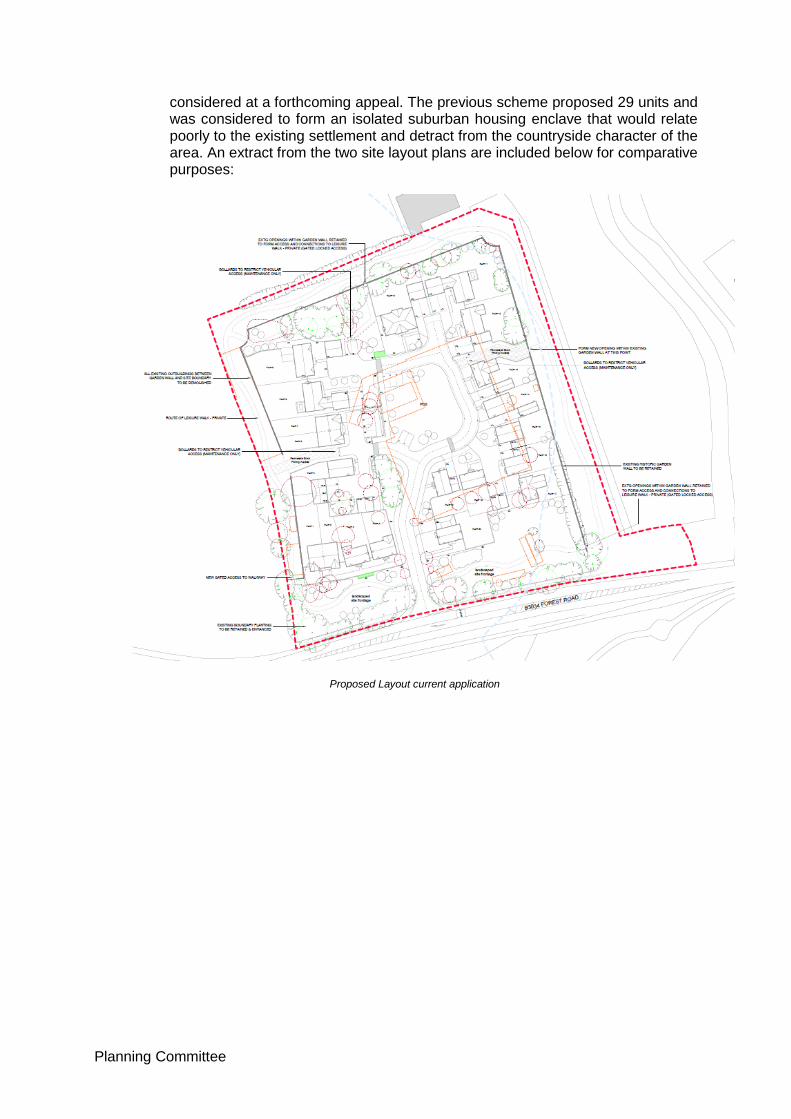
considered at a forthcoming appeal. The previous scheme proposed 29 units and was considered to form an isolated suburban housing enclave that would relate poorly to the existing settlement and detract from the countryside character of the area. An extract from the two site layout plans are included below for comparative purposes:
Proposed Layout current application

Planning Committee
Layout of Refused Scheme – 18/01168/FUL
9.32 It can be seen that the previous scheme, introduced a suburban built form substantially further towards, and more visible from Forest Road. It extended development across the width of the site thereby inhibiting views through the site to the rural backdrop provided by the protected trees on its northern boundary and the woodland planting beyond. 9.33 The harm identified resulted from the formal and highly developed character of
the proposal and the loss of protected trees, in combination with the physical and visual separation of the proposed development from the settlement which together would have a material adverse impact on the character of the countryside, over and above the impact of the existing development.
9.34 Whilst the site clearly remains separate from the settlement, the form of the current application proposal is less suburban in appearance and would be less visually intrusive when viewed from Forest Road than that previously proposed as a result of the greater set back from the road, the greater relief in the form of the development and the views across the proposed area of public open space. It also retains all of the protected trees. 9.35 As a result, the currently proposed development is considered to be materially different from the scheme submitted under 18/01168/FUL and the recommendation for approval made in this instance is entirely consistent with the refusal of the earlier application.
Planning Committee
9.36 In conclusion on this issue, it is considered that the proposed development would not cause any material harm to the character or appearance of the countryside when compared with the existing situation such that, in this respect, the proposed development does not conflict with Policies CS1, CS7, EN8 and EN20 of the development plan. iii. Design
9.37 Policy CS7 of the CSDPD requires a high-quality design for all development that builds on the local character, respecting local patterns of development and the historic environment. Development should enhance the landscape and promote biodiversity and provide high quality usable open spaces.
9.38 The proposed dwellings are two storey and of traditional design using a range of materials, architectural features and detailing found locally. An example of the proposed frontage units is included below:

Planning Committee
9.39 The Urban Design Officer provided detailed comments in respect of the originally submitted layout. Amended plans have been submitted which seek to address concerns raised which include the relocation of the garage on Plot 9, amendments to the parking of Unit 7, a variation in materials and boundary treatments along pedestrian access routes. 9.40 There is a marked change in levels across the site west to east as demonstrated by the streetscene view included below. Whilst this plan provides sufficient information to judge the impact of the proposed dwellings within the streetscene, it does not demonstrate that level access can be provided to the primary entrance of each unit and these details should be secured by condition in the event that planning permission is granted.
9.41 In general, the design of the proposed development is considered to be of high quality, responding appropriately to the local character of the area such that it is acceptable when considered against Policy CS7. iv. Impact on Residential Amenity 9.42 The nearest existing residential property to the site is Toll House, located some 60m to the west and divided from the site by immature woodland planting. Park Cottage lies approximately 100m to the north and is similarly screened from the site. Other residential properties to the west within the settlement of Binfield are located approximately 150 metres away, although the dwellings permitted on appeal (ref: 18/00758/FUL) on the site on the corner of Tilehurst Lane and Church Road will be located somewhat closer at a distance of approximately 85metres from the site boundary, once constructed. Binfield Manor is located c.180 metres to the south-east. 9.43 Given the degree of separation, intermediary screening and the enclosure of the proposed development within the confines of the existing historic wall, it is not considered that the proposed development would cause any loss of amenity to existing occupiers. The proposal is considered to comply with criteria (iv) and (vii) of Policy EN20 of the BFBLP. 9.44 A commercial building thought to be used by Thames Water is located immediately to the north of the application site. However, due to its nature, it is not considered that a residential development would impact upon the amenities of its users. 9.45 In terms of noise generation from construction or otherwise, in view of the siting of the development and the separation distances to relevant properties, it is not considered necessary to control hours of activity. It would however be reasonable to secure a construction management plan in terms of general amenity and

Planning Committee
neighbourliness, along with highway safety and environmental reasons, were the proposal to be approved. v. Impact on Heritage Assets 9.46 Section 66(1) of the Planning (Listed Buildings and Conservation Areas) Act 1990 states that:
‘in considering whether to grant planning permission for development which affects a listed building or its setting, the local planning authority, or, as the case may be, the Secretary of State shall have special regard to the desirability of preserving the building or its setting or any features of special architectural or historic interest which it possesses.’
9.47 CSDPD Policy CS1 states that development shall protect and enhance historic and cultural features of importance. CS7 states that development shall respect the historic environment, Policy EN20 requires development to be in sympathy with the character of the local environment. Policy BF2 of the Binfield Neighbourhood Plan also states that development will be required to sustain and enhance the setting of heritage assets in their vicinity. These policies are considered consistent with the NPPF and given significant weight in the planning balance. 9.48 In particular it is noted that para. 193 of the Framework states that when considering the impact of a proposed development on the significance of a designated heritage asset, great weight should be given to the asset’s conservation. Para. 196 goes on ‘where a development proposal will lead to less than substantial harm to the significance of a designated heritage asset, this harm should be weighed against the public benefits of the proposal including, where appropriate, securing its optimum viable use. Para. 197 refers to the effect of an application on the significance of a non-designated heritage asset and suggests that a balanced judgment is required having regard to the scale of any harm or loss and the significance of the heritage asset. 9.49 The courts have established that the application of the policies set out in NPPF
paras. 193 – 196 corresponds with the section 66(1) requirement to have special regard to the desirability of preserving a listed building its setting.
9.50 The Council’s Conservation Advisor has confirmed that the settings of the Listed Buildings which would potentially be affected by the proposed development would be the Stag and Hounds PH and, to a lesser extent, Binfield Manor and Pitts Bridge. However, it is noted that these listed structures are not enhanced currently by the existing Garden Centre buildings and car park.
9.51 The Stag and Hounds is located to the west of the proposed site, over-looking the site approximately 80m to the east of it. Binfield Manor is located approximately 180m to the south of the development, behind large walls and gates which provide screening from the site. Pitts Bridge is about 60m to the east. All these Listed Buildings are currently impacted negatively by the existing Wyevale Centre.
9.52 In addition to these designated heritage assets there is also an existing unlisted walled garden of 3m high red brick walls. Although the wall is relatively inaccessible due to overgrown scrub and trees it retains its architectural and historic interest as a well-built walled-garden feature formerly belonging to Binfield Manor and is considered a non-designated heritage asset. The repair of the existing wall and incorporation into the open space proposals together with

Planning Committee
a circular walk around the site with interpretation boards reflecting the site’s historic use is considered to be a heritage benefit.
9.53 The Conservation Advisor’s comments conclude:
“The development would replace an existing site occupied by a commercial nursery with car parking which does not contribute the historic character of the area. The proposed brownfield development would replace an existing commercial building which does not contribute to the historic character of the area. The existing historic walled garden structure, as a non-designated heritage asset, has been retained as part of the development and incorporated into it, to preserve part of the areas local historic character.
In summary there are no objections to a residential development on this site subject to conditions’. The conditions recommended relate to the submission and approval of materials for the repair of the wall and insertion of an additional opening within it.
9.54 The proposal is therefore considered to cause no harm to the significance of designated heritage assets and the proposed retention and repair of the existing wall as a non-designated heritage asset is considered of heritage benefit. As a result, the approval of the application is compatible with the s66(1) duty to have special regard to the desirability of preserving the setting of the adjoining listed buildings and is consistent with the Policies of the development plan and the NPPF.
vi. Trees 9.55 The site is subject to a Tree Preservation Order (TPO No. 1299) which identifies 26 individual trees and three groups. This TPO does not cover all of the existing trees, as many of these are recognised to be of limited quality and/or poor health. The Order covers trees on its boundaries, most notably the northern and southern sections, and also towards the centre. 9.56 The previous application for 29 units necessitated the removal of a number of the protected trees, comprising T26 a Cedar located in the centre of the site and two of a group of five maples identified as G3, located on the site’s northern boundary. In addition to the removal of these identified trees, concerns were raised that the proximity of construction, excavation and change in levels of the proposed development would lead to pressure on 8 further protected trees. The Tree Officer objected to the proposed development on this basis and the impact on the character of the area as a result of the loss of protected trees was referred to in the primary reason for refusing this application. 9.57 The current application proposes an amended layout which allows for the retention of all of the protected trees. The Tree Officer accepts that this is a positive amendment to the earlier scheme and also that the relationship of the proposed development to trees on the southern frontage, and western, northern and eastern boundaries is now acceptable. However, refusal is recommended since the proposed layout fails to provide adequate growing space to allow a London Plane (T23) and 3no. cedars (T24, 25 and 26) to reach their growth potential. 9.58 The applicant has submitted a letter in response to the Tree Officer’s comments. This expresses the opinion that there is ample space for the future growth of the

Planning Committee
trees, and in the case of the cedars, much more than they currently have available. 9.59 It is acknowledged that it would be preferable for all trees to be given ample space such that they can grow unrestrained, thereby improving their amenity value and further enhancing the environment. However, it is also relevant that the growing environment of these trees is currently highly constrained by the level of hardstanding that surrounds them, and that this situation would remain in the event that the site be brought back into retail use. 9.60 The trees are shown as being retained, in contrast to the previous scheme, and contribute to the character and amenity of the site and the wider area. An Arboricultural Impact and Method Statement has been submitted which indicates tree protection measures and details proposed construction techniques within the Root Protection Areas of all retained trees which is necessitated in some instances where the removal of hardstanding is required. Adherence to this Method Statement could be secured by condition. 9.61 The Tree Officer remains of the view that the proposed layout fails to provide adequate growing space to allow 4 of the protected trees on site to reach their growth potential. Whilst this is disputed by the applicant, this objection needs to be weighed in the planning balance set out in Section 11 of this report. vii. Impact on Highway Safety
9.62 Revised plans were received on 20 April 2020 which resolve the Highway Authority's previous concerns. In general, the layout is much improved. Access 9.63 It is proposed to re-use the former garden centre access onto Forest Road, where sufficient visibility splays are available. 9.64 The General Arrangement Plan (drawing 18-154/200 revision D) annotates post and rail fencing for pedestrian edge protection adjacent to the ditch along the site frontage. A Planning Condition will be required to secure this, with the detail provided through S278 / S38 agreement with the Highway Authority.
9.65 Bollards will be required to prevent unauthorised access to the block-paved
access between Plot 12 and 13 and at the ends of the footpath to the west of the public open space, in a similar manner to the bollards shown between Plot 5 and Plot 6.
9.66 Visibility splays are shown on the General Arrangement Plan (drawing 18-
154/200 revision D), these should be secured by Planning Condition. Visibility splays should also be provided around the turning head to the west of Plot 12 and south of Plot 10; and for the shared driveway serving plots 15, 16, 17 and 18; a Planning Condition is requested, requiring visibility plan(s) for these areas to be submitted.
Parking 9.67 Parking provision is generally in accordance with the Parking Standards SPD,
March 2016. The revised layout for Plot 14 has triple-tandem on-plot parking, which is not generally supported by the Highway Authority, but is the only property within the development to do so; this removes the need for an on-street space, which would cause conflict with the shared surface and visibility splay, and therefore is considered to be acceptable in this instance only.
Planning Committee
Planning Conditions will be required to ensure parking, garages and carports /
carbarns are retained for parking, cycle storage is provided and in relation to signage of visitor parking.
Refuse Collection 9.68 The access road will need to be constructed to adoptable standards from its
junction with Forest Road including carriageway and adjacent footways / verges / margins up to and including the full extent of the turning head (and adjacent margins) to the west of Plot 12 and south of Plot 10, in order to accommodate refuse collection using BFC's refuse vehicle.
9.69 Bin collection points are shown on the General Arrangement Plan (drawing 18-
154/200 revision D) south-west of Plot 10, for Plots 8 and 9, and south of Plot 3, for Plots 1 and 2, to place bins for collection on the relevant collection day.
viii Drainage 9.70 Part of the site is indicated to be within Flood Zones 2 and 3 and as such a Flood
Risk Assessment (FRA) was submitted in support of the application. The LLFA assessed the submitted information and confirmed that further information would be required. This has been provided in the form of a revised FRA Addendum. The Drainage Officer considers that this revised information is acceptable and recommends approval subject to conditions.
9.71 The Environment Agency has no objections to the proposed development subject to conditions. ix Impact on Biodiversity 9.72 The Biodiversity Officer initially indicated that further information would be required in relation to biodiversity net gain, landscaping proposals, drainage design and proposed boundary treatments in order to demonstrate that the application protects and enhances biodiversity as required by development plan,national policy and legislation. 9.73 Revised information has been submitted and the Biodiversity Officer has confirmed that the application now demonstrates that the development will protect and enhance biodiversity in line with CS1, CS7 the NPPF and NERC Act 2006. x Landscape 9.74 The impact of the proposed development on the landscape character of the area has been considered above. 9.75 The application was accompanied by a detailed landscaping scheme and the Landscape Officer has provided a number of sets of comments in relation to the original scheme and various revisions to it. The latest submission (Revision I) still fails to address all of the comments made. 9.76 Most significantly, it does not show the proposed drainage details so it is not possible to assess whether there is any conflict with the proposed planting and the drainage features. Furthermore, the submitted Soft Landscape Management

Planning Committee
and Maintenance Plan is not considered satisfactory. Therefore it is not intended to approve the currently submitted landscaping details but to secure the submission of an alternative scheme by means of an appropriately worded condition. xi Affordable Housing and Dwelling Mix 9.77 The application does not propose any affordable housing and the applicants claim that the Vacant Buildings Credit applies. 9.78 Para. 63 of the NPPF states that ”To support the re-use of brownfield land, where vacant buildings are being reused or redeveloped, any affordable housing contribution due should be reduced by a proportionate amount”. National Planning Policy Guidance confirms that where existing buildings are being demolished and replaced by new buildings ‘the developer should be offered a financial credit equivalent to the existing gross floorspace of relevant vacant buildings when the local planning authority calculates any affordable housing contribution which will be sought’. This concession does not apply where the buildings have been abandoned, and although the site is currently unoccupied, there is no suggestion that its use has been ‘abandoned’ in planning terms. 9.79 The existing retail garden centre floorspace (excluding lean-to and external retail sales area) is 2802sq.m. The proposed floorspace of the development is 2801.5sqm [Note: this is the gross floorspace of the development and not the footprint i.e. site coverage referred to at para. 9.27 above]. On this basis, Officers are satisfied that the Vacant Buildings Credit applies and that no affordable housing should be required on this site. Given that this concession derives from national planning policy, failure to provide affordable housing in this instance does not result in any conflict with Policies CS16 or CS 17 of the CSDPD. 9.80 The application proposes exclusively 3 and 4 bedroom houses all of which would be for market sale. It is recognised that this does not reflect the mix of dwelling sizes, types and tenures identified in the SHMA (2016) and as a result the scheme conflicts with Policy CS16 of the CSDPD. 9.81 However, the previous application for the site proposed a higher density form of development with a greater mix of dwellings and this was judged to result in a suburban form of development, detrimental to the character of the area. As a result, the failure to provide a greater mix of dwelling sizes, particularly of smaller dwellings, although contrary to Policy CS16 of the CSDPD is given only limited weight in the planning balance.
xii Thames Basin Heaths Special Protection Area (SPA) 9.82 The site is located 5.2km away from the Thames Basin Heaths SPA and proposes fewer than 50 dwellings. In accordance with advice from Natural England it is considered that the proposal is not likely to have a significant effect (either individually or in combination with other plans or projects) on a protected habitats site and accordingly no Appropriate Assessment is required in this instance xiii Sustainability 9.83 CSDPD Policy CS10 requires the submission of a Sustainability Statement covering water efficiency aimed at achieving an average water use in new dwellings of 110
Planning Committee
litres/person/day. Policy CS12 requires the submission of an Energy Demand Assessment demonstrating how 10% of the development's energy requirements will be met from on-site renewable energy generation. Both of these requirements can be secured by means of appropriately worded conditions. xiv Contamination 9.84 CSDPD CS1 requires development to protect and enhance the health and safety of the local population. BFBLP ‘Saved’ Policy EN25 states that development will not be permitted if it would generate unacceptable levels of pollution which would adversely affect the amenities of the occupiers of the buildings. These policies are consistent with paras. 118 and 170 of the NPPF which state that planning authorities should support appropriate opportunities to remediate contaminated land. 9.85 In view of the previously developed state of the site and its former commercial use, there is the potential for land contamination and the application is accompanied by a Phase 1 Geo-environmental Risk Assessment Report which includes recommendations about further investigation works that should be carried out in order to inform a remediation strategy for the site. The Environmental Health Officer recommends a condition in the event that planning permission is granted which would include the undertaking of a risk assessment, the submission and implementation of a remediation scheme actions in the event that unexpected contamination is discovered and, if necessary, long term monitoring and maintenance. xv Waste 9.86 The Waste and Recycling Officer has confirmed that the revised plans indicates acceptable collection points for waste and recycling collection and assumes that other properties will present their bins for collection at the nearest adopted highway. xvi Securing Necessary Infrastructure 9.87 The CIL Bracknell Forest Council introduced charging for its Community Infrastructure Levy (CIL) on 6th April 2015. CIL is applied as a charge on each square metre of new development. The amount payable varies depending on the location of the development within the borough and the type of development. 9.88 In this instance, the scheme is unlikely to be CIL liable as any chargeable floorspace can be off-set by that of existing buildings providing that they have been in continuous lawful use for 6 months in the last 3 years, with the 3 year period ending on the date the planning permission is issued. This requirement can currently be met. 9.89 CSDPD Policy CS6 states that the development is expected to contribute to the delivery of infrastructure needed to support growth and infrastructure needed to mitigate impacts upon communities, transport and the environment. 9.90 The Planning Obligations SPD (2015) is also applicable. If planning permission were to be granted, the following would be secured by means of a Section 106 Legal Agreement:
contribution of £2300 per dwelling (index linked) towards community facility improvements at Farley Hall Community Centre
Planning Committee
specification for on-site open space, management and maintenance plan (and commuted sum if developer wishes to transfer open space to Council for future maintenance and management)
off-site contribution of £17000 towards Active OSPV for improvements to tennis facilities at Farley Wood Centre
Specification of SUDS features and Maintenance and Management Plan including monitoring contribution
9.91 It should be noted that the Implementation Officer’s comments refer to the
Council seeking the applicant to dedicate a strip of land across the site’s frontage to allow the Council to implement footway/cycle way improvements in the future. This option has been investigated and the applicant has provided details of a potential scheme. However, this necessitated culverting the ditch and/or would require the felling of, or would put at risk protected trees along the site’s frontage. Accordingly, it has been concluded that it would not be prudent to continue to request cycleway provision, or the land to achieve this and so this requirement is no longer being pursued.
10. WEIGHING THE PLANNING BALANCE 10.1 The Council can currently demonstrate a 5-year Housing Land Supply and considers the most important policies for the determination of this application to be up-to-date for the purposes of para. 11 of the NPPF. Therefore, the application should be determined in accordance with the development plan unless material considerations dictate otherwise. 10.2 The application site lies within the countryside beyond any settlement boundary. The provision of new residential development in the countryside is contrary to policies CS2, CS9, EN8 and H5 of the development plan. Whilst, Policy CS2 is considered to be fully consistent with the NPPF, policies CS9, EN8 and H5 are not, and therefore any conflict with these latter policies is given more limited weight in the planning balance. 10.3 The NPPF requires LPAs to take a positive approach to applications for alternative uses of previously developed land, and gives the example of where retail land is proposed for homes in areas of high housing demand it should be supported provided that this would not undermine key economic sectors, the vitality and viability of town centres and would be compatible with other policies in the Framework (para. 121). 10.4 In this instance, there is no policy protection for the retention of the lawful retail use and an assessment of the scheme’s impact on the character and beauty of the countryside has concluded that the proposed development would not cause material harm when compared with the existing development on site. This is compatible with the Framework’s requirement to recognise the intrinsic character and beauty of the countryside (para. 170) and to be sympathetic to the local character and history, including the surrounding built environment and landscape setting (para. 127). 10.5 The application has been assessed in respect of all other issues including highways, heritage, biodiversity, affordable housing and sustainability and has been found to be consistent with relevant policies. Although the size and mix of the proposed dwellings results in some conflict with Policy CS16, this conflict is given limited weight in the planning balance for the reason outlined in Section

Planning Committee
9 of this report. It is acknowledged that the Tree Officer recommends refusal of the application on grounds that the proposed development would not provide adequate growing space to allow protected trees on site to meet their full growth potential. However, the scheme allows for the retention of all protected trees on site, which will continue to make a contribution to the visual amenities of the area. In light of their existing restricted growing conditions, which would remain if an alternative use of the site is not secured, it is considered that this concern can only be given limited weight in the planning balance. 10.6 The application proposes 20 units of residential accommodation. Whilst none of these would be affordable, the provision of new housing is consistent with the Government’s policy to significantly boost the supply of homes. The provision of such housing would provide economic benefits relating to their construction and spending within the local economy by residents, although due to the buoyancy of the local economy, the fact that the use of the site for retail purposes would also result in local economic benefits, and in line with previous appeal decisions, these benefits are afforded only limited weight. 10.7 The scheme is unlikely to be CIL liable as any chargeable floorspace can be off- set by that of existing buildings providing that they have been in continuous lawful use for 6 months in the last 3 years, with the 3 year period ending on the date the planning permission is issued. This would currently appear to be the case. 10.8 Whilst the development would result in contributions towards community infrastructure and public open space, these issues are requirements of adopted policy, rendered necessary by the specific nature of the scheme and therefore are given no material weight in the planning balance. 10.9 The application will however result in the restoration and better appreciation of the walled-garden feature as a non-designated heritage asset and this environmental benefit is given moderate weight in the planning balance. 10.10 In weighing the planning balance, and given their consistency with the NPPF, the development’s identified conflict with Policy CS2 should be given significant weight, conflict with Policies CS9 and EN8 be given moderate weight, and conflict with Policies H5 and CS16 be given some, limited, weight. The concerns of the Tree Officer should also be noted. Against this should be weighed the absence of material harm to the character and appearance of the countryside when compared with the existing development on site; the support contained within the NPPF for the re-use of previously developed sites in instances where this is compatible with other policies in the Framework; benefits associated with the provision of the new housing; and some economic and environmental benefits as outlined above. 10.11 Taking all these matters into consideration, it is concluded that the material considerations outlined in this report, outweigh the identified conflict with the development plan and the application is recommended for conditional approval on the completion of a s106 Agreement as set out in the Recommendation below. 11. RECOMMENDATION

Planning Committee
Following the completion of planning obligation(s) under Section 106 of the Town and Country Planning Act relating to:
A contribution towards community facility improvements at Farley Hall Community Centre
Management and maintenance plan for on-site open space (and commuted sum if developer wishes to transfer open space to Council for future maintenance and management)
Contribution towards Active OSPV for improvements to tennis facilities at Farley Wood Centre
SuDS specification and Maintenance and Monitoring Scheme including monitoring contribution
S278 agreement to secure minor improvements to pedestrian footway on the northern side of Forest Road and improved road markings along Forest Road in the immediate vicinity of the site access.
That the Head of Planning be authorised to APPROVE the application subject to the following conditions:-
01. The development hereby permitted shall be begun before the expiration of 3
years from the date of this permission.
REASON: To comply with Section 91 of the Town and Country Planning Act 1990.
02. The development hereby permitted shall be carried out in accordance with the
following approved plans: 20-J3173-LP Location Plan received 02.03.2020 20-J3173-EBST200D External Boundary and Surface Treatment Plan received 01.06.2020 20 – J3173-100A Streetscenes AA and BB received 7.05.2020
20 – J3173-100A Streetscenes AA and BB received 7.05.2020 20-J3173-01B Proposed Site Layout received 07.05.2020 20-J3173 - 02 Plot 1 and 2 Elevations received 02.03.2020 20-J3173 - 03 Plot 1 and 2 Floor Plans received 02.03.2020 20-J3173-04A Plot 3 Elevations received 07.05.2020 20-J3173 - 05 Plot 3 Floor Plans received 02.03.2020 20-J3173 - 06 Plot 4 Elevations received 02.03.2020 20-J3173 - 07 Plot 4 Floor Plans received 02.03.2020 20-J3173 – 08A Plot 5 Elevations received 17.04.2020 20-J3173 – 09A Plot 5 Elevations received 17.04.2020 20-J3173 – 10 Plot 6 and & Elevations received 02.03.2020 20-J3173 – 11 Plot 6 and & Floor Plans received 02.03.2020 20-J3173 – 12A Plot 8 Elevations received 17.04.2020 20-J3173 – 13A Plot 8 Elevations received 17.04.2020 20-J3173 – 14A Plot 8 Floor Plans received 17.04.2020 20-J3173 – 15 Plot 8 Floor Plans received 02.03.2020 20-J3173 – 16 Plot 9 Elevations received 02.03.2020 20-J3173 – 17 Plot 9 Floor Plans received 02.03.2020 20-J3173 – 18 Plot 10 Elevations received 02.03.2020 20-J3173 – 19 Plot 10 Floor Plans received 02.03.2020 20-J3173 – 20 Plot 11 Elevations received 02.03.2020 20-J3173 – 21 Plot 11 Floor Plans received 02.03.2020
Planning Committee
20-J3173 – 22A Plot 12 Elevations received 17.04.2020 20-J3173 – 23A Plot 12 Floor Plans received 17.04.2020 20-J3173 – 24 Plot 13 Elevations received 02.03.2020 20-J3173 – 25 Plot 13 Floor Plans received 02.03.2020 20-J3173 – 26 Plot 14 Elevations received 02.03.2020 20-J3173 – 27 Plot 14 Floor Plans received 02.03.2020 20-J3173 – 28 Plots 15 and 16 Elevations 02.03.2020 20-J3173 – 29 Plots 15 and 16 Floor Plans 02.03.2020 20-J3173 – 30 Plots 15 and 16 Floor Plans 02.03.2020 20-J3173 – 31A Plot 17 Elevations received 17.04.2020 20-J3173 – 32A Plot 17 Floor Plans received 17.04.2020 20-J3173 – 33A Plot 18 Elevations received 17.04.2020 20-J3173 – 34A Plot 18 Floor Plans received 17.04.2020 20-J3173 – 35A Plot 20 Elevations received 17.04.2020 20-J3173 – 36A Plot 20 Floor Plans received 17.04.2020 20-J3173 – 37A Car barns to Plots 1, 2 and 5 received 17.04.2020 20-J3173 – 38A Car barns to Plots 3-4 and 17-18 received 17.04.2020 20-J3173 – 39 Single garages to Plots 13 and 14 received 02.03.2020 20-J3173 – 40 Double Garage to Plot 9 received 02.03.2020 20-J3173 – 41 Double Garage to Plot 10 received 02.03.2020 20-J3173 – 42 Plot 19 Elevations received 17.04.2020 20-J3173 – 43 Plot 19 Floor Plans received 17.04.2020 20-J3173- FM200A Facing Materials Plan received 17.04.2020 20-J3173-FBT200 Feature Boundary Treatments received 02.03.2020 20-J3173-POS200A Public open space plan received 17.04.2020 18-154/200 D General Arrangement received 17.04.2020
REASON: To ensure that the development is carried out only as approved. 03. Notwithstanding the information indicated on the Facing Materials Plan 20-J3173-
FM200, no structure hereby permitted shall be built above damp-proof course
level until samples of the materials to be used in the construction of the external
surfaces of the development hereby permitted have been submitted to and
approved in writing by the Local Planning Authority. The development shall be
carried out in accordance with the approved details.
REASON: In the interests of the visual amenities of the area.
04. The development hereby permitted shall not commence until details showing the finished floor levels of the dwellings hereby approved in relation to a fixed datum point have been submitted to and approved in writing by the Local Planning Authority and the development shall be carried out in accordance with the approved details. Finished floor levels shall be set no lower than 47.60 metres above Ordnance Datum as shown in Appendix A of the Flood Risk Addendum 1.
REASON: In the interest of the character of the area, to ensure level access for
future occupiers and to reduce the risk of flooding to future occupants in
accordance with para. 163 of the NPPF.
[Relevant Policies: BFBLP EN20, Core Strategy DPD CS7]
05. Notwithstanding the provisions of the Town and Country Planning (General Permitted Development) (England) Order 2015 (or any Order revoking and re- enacting that order with or without modification), no enlargement, addition, improvement or other alteration permitted by Classes A, B, C, D and E of Part 1

Planning Committee
of the Second Schedule of the 2015 Order shall be carried out to the dwellings hereby permitted. REASON: The site is located in a countryside location where strict controls over the form, scale and nature of development are required to preserve the intrinsic character and beauty of the countryside. Furthermore, the site is subject to a Tree Preservation Order where strict control over future development is required in order to ensure future protection of valued trees. 06. Notwithstanding the provisions of Part 1 Class F of the Second Schedule of the Town and Country Planning (General Permitted Development) (England) Order 2015 (or any Order revoking and re-enacting that order with or without modification), no hard surface shall be provided for any purpose within the curtilage of the dwellinghouse. REASON: In the interest of the health of nearby trees. 07. Notwithstanding the provisions of the Town and Country Planning (General Permitted Development) (England) Order 2015 (as amended) (or any order revoking and re-enacting that order with or without modification), no windows at first floor level or above shall be installed on the following elevations of the dwellings hereby approved, with the exception of those shown on the approved plans: i) Eastern side elevation of Plots 2 and10 ii) Western side elevation of Plot 4 iii) Both side elevations of Plots 3, 8,12,13,14,15,16 and 18 iv) North-facing elevations of Plots 5, 7, 17 and 20, and iv) South-facing side elevations of Plots 6, 9, 11 and 19. REASON: In the interests of the amenity of future occupiers. 08. The following first-floor windows of the dwellings hereby permitted, shall not be
glazed at any time other than with a minimum of Pilkington Level 3 obscure glass (or equivalent). It shall at all times be fixed with the exception of a top hung openable fanlight: i) South-facing elevation to Plots 5, 8, 14 and 16 ii) East and west elevations to Plot 10, iii) North-facing elevation to Plot 15. Any replacement windows shall be glazed and fixed to this standard, and retained as such.
REASON: In the interests of the amenity of future occupiers. 09. No dwelling shall be occupied until details have been submitted to the Local Planning Authority confirming that provision has been made for the installation of superfast broadband (fibre optic) internet connections for the entire development. REASON: In the interests of the amenities of future occupiers.
10. Development other than that required to be carried out as part of an approved scheme of remediation must not commence until parts 1 to 4, and part 5 if required, of this condition have been complied with. If unexpected contamination is found after development has begun, development must be halted on that part of the site affected by the unexpected contamination to the extent specified by the Local Planning Authority in writing until part 4 has been complied with in relation to that contamination.
Planning Committee
1. Site Characterisation
An investigation and risk assessment, in addition to any assessment provided with the planning application, must be completed in accordance with a scheme to assess the nature and extent of any contamination on the site, whether or not it originates on the site. The contents of the scheme are subject to the approval in writing of the Local Planning Authority. The investigation and risk assessment must be undertaken by competent persons and a written report of the findings must be produced. The written report is subject to the approval in writing of the Local Planning Authority. The report of the findings must include:
(i) a survey of the extent, scale and nature of contamination;
(ii) an assessment of the potential risks to:
• human health,
• property (existing or proposed) including buildings, crops, livestock, pets, woodland and service lines and pipes,
• adjoining land,
• groundwaters and surface waters,
• ecological systems,
• archeological sites and ancient monuments;
(iii) an appraisal of remedial options, and proposal of the preferred option(s).
This must be conducted in accordance with DEFRA and the Environment Agency’s ‘Model Procedures for the Management of Land Contamination, CLR 11’.
2. Submission of Remediation Scheme
A detailed remediation scheme to bring the site to a condition suitable for the intended use by removing unacceptable risks to human health, buildings and other property and the natural and historical environment must be prepared, and is subject to the approval in writing of the Local Planning Authority. The scheme must include all works to be undertaken, proposed remediation objectives and remediation criteria, timetable of works and site management procedures. The scheme must ensure that the site will not qualify as contaminated land under Part 2A of the Environmental Protection Act 1990 in relation to the intended use of the land after remediation.
3. Implementation of Approved Remediation Scheme
The approved remediation scheme must be carried out in accordance with its terms prior to the commencement of development other than that required to carry out remediation, unless otherwise agreed in writing by the Local Planning Authority. The Local Planning Authority must be given two weeks written notification of commencement of the remediation scheme works.
Following completion of measures identified in the approved remediation scheme, a verification report that demonstrates the effectiveness of the remediation carried out must be produced, and is subject to the approval in writing of the Local Planning Authority.

Planning Committee
4. Reporting of Unexpected Contamination
In the event that contamination is found at any time when carrying out the approved development that was not previously identified it must be reported in writing immediately to the Local Planning Authority. An investigation and risk assessment must be undertaken in accordance with the requirements of part 1, and where remediation is necessary a remediation scheme must be prepared in accordance with the requirements of part 2, which is subject to the approval in writing of the Local Planning Authority.
Following completion of measures identified in the approved remediation scheme a verification report must be prepared, which is subject to the approval in writing of the Local Planning Authority in accordance with part 3.
If required:
5. Long Term Monitoring and Maintenance
A monitoring and maintenance scheme to include monitoring the long-term effectiveness of the proposed remediation over a period to be agreed with Local Planning Authority, and the provision of reports on the same must be prepared, both of which are subject to the approval in writing of the Local Planning Authority.
Following completion of the measures identified in that scheme and when the remediation objectives have been achieved, reports that demonstrate the effectiveness of the monitoring and maintenance carried out must be produced, and submitted to the Local Planning Authority.
This must be conducted in accordance with DEFRA and the Environment Agency’s ‘Model Procedures for the Management of Land Contamination, CLR 11’.
REASON: To ensure that risks from land contamination to the future users of the land and neighbouring land are minimised, together with those to controlled waters, property and ecological systems, and to ensure that the development can be carried out safely without unacceptable risks to workers, neighbours and other offsite receptors.
11. There shall be no built development or raising of existing ground levels on site within the 1% annual exceedance probability flood extent with an appropriate allowance for climate change. REASON: To prevent an increase in flood risk elsewhere and to reduce the risk of flooding to the proposed development and future occupants in accordance with para. 163 of the NPPF. 12. The development shall not be begun until a Sustainability Statement covering
water efficiency aimed at achieving an average water use in new dwellings of 110 litres/person/day, has been submitted to, and agreed in writing by, the Local Planning Authority. The development shall be implemented in accordance with the Sustainability Statement, as approved, and retained as such thereafter.
Reason: In the interests of sustainability and the efficient use of resources.

Planning Committee
13. The development hereby permitted shall be implemented in accordance with the submitted Energy Statement prepared by JSP Ltd Sustainability dated February 2020 and thereafter the buildings constructed by the carrying out of the development shall be operated in accordance with the submitted Energy Statement. The renewable energy shall be installed and operated in accordance with the Energy Statement prior to occupation.
Reason: In the interests of sustainability and the efficient use of resources. 14. No dwelling shall be occupied unless and until an interpretation board identifying the heritage interest of the retained walled-garden feature has been erected in accordance with details which have been submitted to and approved by the Local Planning Authority. The Interpretation board shall thereafter be maintained in a good condition and retained. REASON: In the interests of understanding the historic environment.
15. No work shall be undertaken to the historic wall until the following details have been submitted to and approved in writing by the local planning authority:
a) Sample panels of all facing brickwork which demonstrates the brick types, colours, textures, face bonds, mortar mixes and pointing styles, are to be erected on site, to be maintained there during the course of construction and may be incorporated in the approved works;
b) Samples and/or manufacturer's details of the roof materials are to be provided;
The repair of the historic wall shall be completed prior to the first occupation of any dwelling hereby permitted and shall not be carried out otherwise than in accordance with the details thus approved.
REASON: In order to safeguard the settings of the Listed Buildings and the non- designated heritage asset in accordance with the requirements of national and development plan policy. 16. The development hereby permitted shall not be begun until a scheme has been submitted to and approved in writing by the Local Planning Authority, for off-site highway works comprising: (a) Minor improvements to pedestrian footway on the northern side of Forest Road, including provision of tactile paving dropped-kerb crossing of the site access and edge protection to the rear of the footway along the site frontage, to improve safety for pedestrians; and (b) Improved road markings along Forest Road in the immediate vicinity of the site access. The dwellings provided by the carrying out of the development shall not be occupied until the offsite highway works have been completed in accordance with the approved scheme, and in accordance with a s278 agreement to be completed with the Local Highway Authority. REASON: In the interests of highway safety. [Relevant Policies: BFBLP M6, Core Strategy DPD CS23

Planning Committee
17. No development shall take place until a plan has been submitted to and approved in writing by the Local Planning Authority which shows the area between the forward visibility curve and highway boundary to the north of the approved public open space. The area between the forward visibility curve and highway boundary to the north of the approved public open space shall thereafter be kept free of all obstructions to visibility over a height of 0.6 metres measured from the surface of the adjacent carriageway. REASON: In the interests of highway safety. [Relevant Policies: BSP T1, Core Strategy DPD CS23] 18. No development shall take place until a plan showing visibility splays between the shared accessway serving plots 15, 16, 17 and 18 and the access road through the development has been submitted to and approved in writing by the Local Planning Authority. The development shall be carried out in accordance with the approved details. The visibility splays shall thereafter be kept free of all obstructions to visibility over a height of 0.6 metres measured from the surface of the adjacent carriageway. REASON: In the interests of highway safety. [Relevant Policies: BSP T1, Core Strategy DPD CS23] 19. No dwelling shall be occupied until the visibility splays and forward visibilities shown on the General Arrangement Plan (drawing 18-154/200 revision D) have been provided. These areas shall thereafter be kept free of all obstructions to visibility over a height of 0.6 metres measured from the surface of the adjacent carriageway. REASON: In the interests of highway safety. [Relevant Policies: BSP T1, Core Strategy DPD CS23] 20. No dwelling shall be occupied until that part of the access road which provides access to the dwelling and its parking, along with adjacent footways, margins and street lighting, has been constructed in accordance with the approved plans. REASON: In the interests of highway safety. [Relevant Policies: BSP T1, Core Strategy DPD CS23]
21. Dwellings on plots 1, 2, 3, 4, 5, 6, 7, 8, 9, 15, 16, 17 and 18 shown on the approved plans shall not be occupied until that part of the shared accessway or shared footpath which provides access to the dwelling and its parking, along with adjacent margins and street lighting placed within these margins, has been constructed in accordance with the approved plans.
REASON: In the interests of highway safety. [Relevant Policies: BSP T1, Core Strategy DPD CS23] 22. No dwelling shall be occupied until the associated vehicle parking and turning
space has been surfaced and marked out in accordance with the approved drawing. The spaces shall thereafter be kept available for parking at all times.
REASON: To ensure that the development is provided with adequate car parking
to prevent the likelihood of on-street car parking which would be a danger to other road users.
[Relevant Policies: BSP T1, BFBLP M9, Core Strategy DPD CS23]

Planning Committee
23. The car barns hereby approved for plots 1, 2, 3, 4, 5, 15, 16, 17, 18 and 19 on the approved plans shall be retained for the use of the parking of vehicles at all times and, notwithstanding the provisions of the Town and Country (general Permitted Development) Order 1995 (or any order revoking or re-enacting that Order with or without modification), no enlargements, improvements or alterations shall be made to the car barn, and no gate or door shall be erected to the front of the car barn.
REASON: To ensure that the development is provided with adequate parking to
prevent the likelihood of on-street parking which could be a danger to other road users.
[Relevant Policy: BFBLP M9] 24. Within the garage accommodation hereby approved for plots 8, 9, 10, 12, 13, 14
and 20 on the approved plans, an area of at least 6.0m back from the garage door by 3.5m in width shall be retained for the use of the parking of vehicles at all times.
REASON: To ensure that the Local Planning Authority's vehicle parking
standards are met. [Relevant Policy: BFBLP M9] 25. No development shall take place until a scheme has been submitted to and
approved in writing by the Local Planning Authority for covered and secure cycle parking facilities. No dwelling shall be occupied until the approved scheme has been implemented. The facilities shall be retained thereafter.
REASON: In the interests of accessibility of the development to cyclists. [Relevant Policies: BFBLP M9, Core Strategy DPD CS23] 26. No gates shall be provided at the vehicular access to the site. REASON: In the interests of highway safety. [Relevant Policies: BSP T1, Core Strategy DPD CS23] 27. Bollards to restrict vehicular movement, or a suitable alternative submitted to and
approved in writing by the Local Planning Authority, shall be provided in the following locations within the development, and thereafter retained:
(a) at all of the locations indicated on the approved Proposed Site Layout plan (drawing number 20-J3173-01 revision A);
(b) at the western end of the permeable block paved access, south of the car parking for plot 12 and north of the front garden for plot 13 shown on the approved plans, to the east service margin alongside the access road; and
(c) at the northern and southern ends of the footpath which forms the western boundary of the public open space shown on the approved plans.
REASON: In the interest if highway safety, to prevent vehicles from driving along
or parking in unsuitable locations, which would be a danger to pedestrians and other road users.
[Relevant Policies: BFBLP M6, Core Strategy DPD CS23] 28. No development shall take place until: (a) details of the location and proposed construction of 5 visitor car parking
spaces, and (b) details of the signing for the visitor car parking spaces

Planning Committee
have been submitted to and approved in writing by the Local Planning Authority. The visitor car parking spaces shall be provided and signed in accordance with the approved details and the spaces and signage shall thereafter be retained.
REASON: To ensure that the development is provided with adequate car parking
to prevent the likelihood of on-street car parking which would be a danger to other road users.
[Relevant Policies: BSP T1, BFBLP M9, Core Strategy DPD CS23] 29. The access road shall be constructed to adoptable standards from its junction
with Forest Road up to and including the full extent of the turning head to the west of Plot 12 and south of Plot 10 shown on the approved plans, including carriageway suitable to accept a 26 tonne waste collection vehicle and adjacent footways, verges and margins.
REASON: In order to accommodate refuse collection using Bracknell Forest
Council's refuse vehicle. 30. Dwellings 1, 2, 8, and 9 shall not be occupied until the associated bin collection
point has been provided in the location shown on the approved plan: (a) south of Plot 3, for use by dwellings on Plots 1 and 2; and (b) south-west of Plot 10, for use by dwellings on Plots 8 and 9; for residents to place bins for collection on the relevant collection day. REASON: To ensure that refuse collection can be undertaken for the
development. 31. No development (including demolition and site clearance) shall take place, until a Construction (and Demolition) Environmental Management Plan (CEMP) has
been submitted to and approved in writing by the local planning authority. The CEMP shall include as a minimum; (i) Routing of construction and demolition traffic (including directional signage and
appropriate traffic management measures); (ii) Details of the parking of vehicles of site operatives and visitors; (iii) Areas for loading and unloading of plant and materials; (iv) Areas for the storage of plant and materials used in constructing the
development; (v) Location of any temporary portacabins and welfare buildings for site
operatives; (vi) Details of any security hoarding; (vii) Details of any external lighting of the site; (viii) Details of the method of piling for foundations; (ix) Measures to control the emission of dust, dirt, noise and odour during
demolition and construction; (x) Measures to control surface water run-off during demolition and construction; (xi) construction and demolition working hours and hours during which delivery
vehicles or vehicles taking materials away are allowed to enter or leave the site; (xii) Details of wheel-washing facilities during both demolition and construction
phases; and (xiii) Areas for the turning of construction and demolition vehicles such that the
largest anticipated vehicle can turn and leave the site in a forward gear. The approved Construction Environmental Management Plan shall be adhered to
throughout the demolition and construction period.

Planning Committee
REASON: In the interests of highway safety and to mitigate and control environmental effects during the demolition and construction phases.
Relevant Policies: BFBLP EN20, EN25, M9; Core Strategy DPD CS1, CS7, CS23.
32. No dwelling/ building hereby permitted shall be occupied until hard and soft landscaping works have been completed in full accordance with a landscaping scheme that has been submitted to and approved in writing by the Local Planning Authority. The landscaping scheme shall include:
(a) Comprehensive planting plans of an appropriate scale and level of detail that provides adequate clarity including details of ground preparation and all other operations associated with grass and plant establishment, full schedules of plants, noting species and detailed plant sizes/root stock specifications, planting layout, proposed numbers/ densities, location.
(b) Details of semi-mature tree planting including large native trees in the central area of open space,
(c) comprehensive 5 year post planting maintenance schedule, (d) Underground service and external lighting layout (drainage, power
communications cables, pipelines etc. indicating lines, manholes etc.) both existing, reused and proposed new routes
(e) Samples of the materials to be used in the hard surfacing of the areas shown on the Surface Treatment Plan 20 – J3173-EBST200D
(f) Recycling/refuse or other storage units, play equipment (g) Other landscape features All planting comprised in the soft landscaping works shall be carried out and
completed in full accordance with the approved details in the nearest planting season (1st October to 31st March inclusive) to the completion of the development or prior to the occupation of any part of the approved development, whichever is sooner, or as may otherwise be agreed in writing by the Local Planning Authority. All hard landscaping works shall be carried out and completed prior to the occupation of any part of the approved development. As a minimum, the quality of all hard and soft landscape works shall be carried out in accordance with British Standard 4428:1989 ‘Code Of Practice For General Landscape Operations’ or any subsequent revision. All trees and other plants included within the approved details shall be healthy, well-formed specimens of a minimum quality that is compatible with British Standard 3936:1992 (Part 1) ‘Specifications For Trees & Shrubs’ and British Standard 4043 (where applicable) or any subsequent revision. Any trees or other plants which within a period of 5 years from the completion of the development, die, are removed, uprooted, are significantly damaged, become diseased or deformed, shall be replaced during the nearest planting season (1st October to 31st March inclusive) with others of the same size, species and quality as approved.
REASON: In the interests of good landscape design and the visual amenity of the area.
33. The protective fencing indicated on the Tree Protection Plan SPIT2195-03G
(Appendix 3 of the Arboricultural Impact Assessment and Method Statement received by the Local Planning Authority on 02.03.2020), shall be erected in the locations indicated prior to the commencement of the development, including any initial site clearance, and shall be maintained fully intact and upright. Nothing shall be stored or placed in any area fenced in accordance with this condition and the ground levels within those areas shall not be altered, nor shall any excavation be made, other than the removal of existing hardstanding in

Planning Committee
accordance with the techniques set out in the submitted Method Statement. The fencing shall be retained in its agreed location during the course of construction works, noting that this involves some re-siting of the protective fencing post-demolition. The development shall be carried out in accordance with the submitted Method Statement which includes other protective measures such as no dig construction areas and sensitive demolition.
REASON: In order to safeguard trees and other vegetation in the interest of the
character and amenity of the area. 34. All boundary treatments (fencing, hedges, walls) shall be implemented on each
plot prior to its occupation, in accordance with the approved details as shown on Drawing 20-J3173-EBST200D External Boundary and Surface Treatment Plan received 01.06.2020, and thereafter permanently retained.
REASON: In the interests of the amenities of the area. 35. If more than 2 years elapse between the previous phase 1 and phase 2
ecological surveys and the due commencement date of works, an updated survey shall be carried out by a suitably qualified ecologist. A report confirming the results and implications of the assessment, including any revised mitigation measures, shall be submitted to the Local Planning Authority before construction works commence on site.
REASON: To ensure the status of priority and protected habitats and species on site has not changed since the last survey.
36. No development shall take place (including ground works and vegetation clearance) until a construction environmental management plan (CEMP: Biodiversity) has been submitted to and approved in writing by the local planning authority. The CEMP (Biodiversity) shall include the following: a) Risk assessment of potentially damaging development activities b) identification of "biodiversity protection zones" c) practical measures (both physical measures and sensitive working practices) to avoid or reduce impacts during development (may be provided as a set of method statements) d) the location and timing of sensitive works to avoid harm to biodiversity features e) the times during development when specialist ecologists need to be present on site to oversee works f) responsible persons and lines of communication g) the role and responsibilities on site of an ecological clerk of works or similarly competent person h) the use of protective fences, exclusion barriers and warning signs The approved CEMP (Biodiversity) shall be adhered to and implemented throughout the development period strictly in accordance with the approved details. REASON: To protect biodiversity throughout construction works.
37. A landscape and ecological management plan (LEMP) shall be submitted to, and approved in writing by, the local planning authority prior to the occupation of the development. The content of the LEMP shall include the following: a) Description and evaluation of features to be managed b) Ecological trends and constraints on site that might influence management

Planning Committee
c) Aims and objectives of management d) Appropriate management options for achieving aims and objectives e) Prescriptions for management actions f) Preparation of a work schedule (including an annual work plan capable of being rolled forward over a five-year period) g) Details of the body or organization responsible for implementation of the plan h) On-going monitoring and remedial measures The LEMP shall also include details of the legal and funding mechanism(s) by which the long-term implementation of the plan will be secured by the developer with the management bodies responsible for its delivery. The plan shall also set out (where the results from monitoring show that conservation aims and objectives of the LEMP are not being met) how contingencies and/or remedial action will be identified, agreed and implemented so that the development still delivers the fully functioning biodiversity objectives of the originally approved scheme. The approved plan shall be implemented in accordance with the approved details.
REASON: In the interests of Biodiversity. 38. No dwelling hereby permitted shall be occupied until a scheme has been
submitted to and approved in writing by the Local Planning Authority for external site lighting, including details of lighting units, [and levels of illumination] [and hours of use]. No lighting [other than domestic security or garden lighting installed in individual dwellings] shall be provided at the site other than in accordance with the approved details. The development shall be carried out in accordance with the approved scheme.
REASON: In the interests of Biodiversity. 39. No development shall commence until a scheme for the provision of biodiversity
enhancements (not mitigation), including a plan or drawing showing the location of these enhancements, has been submitted to and approved in writing by the local planning authority. The approved scheme shall be performed, observed and complied with. An ecological site inspection report shall be submitted within six months of the first occupation of any dwelling hereby approved.
REASON: In order to ensure biodiversity enhancement in accordance with the
NPPF. 40. No development shall take place until full details of the Drainage System(s) have
been submitted to and approved in writing by the Local Planning Authority in accordance with the rates set out in the Odyssey FRA dated February 2020, FRA Addendum 1 dated February 2020, and FRA Addendum 2 dated May 2020.
These shall include: Results of intrusive ground investigations demonstrating the depth of the seasonally high groundwater table. Full details of all components of the proposed drainage system including dimensions, locations, gradients, invert and cover levels, geocellular unit and distributer unit design (including guarantees of structural performance) headwall

Planning Committee
details, planting (as necessary), silt control measures and drawings as appropriate taking into account the groundwater table. Confirmation of the gully spacing calculations to demonstrate they are capable of conveying the rainfall volumes to tanks as set out in the Approved Drainage strategy.
REASON: To ensure that the site is properly drained and does not increase the risk of flooding In accordance with policy CS1 of the Core Strategy.
41. No dwelling hereby permitted shall be occupied or the use commenced until the
sustainable drainage scheme for this site has been completed in accordance with the submitted details. The sustainable urban drainage scheme shall be managed and maintained thereafter in accordance with the agreed management and maintenance plan. Written confirmation of agreements for the management and maintenance of the drainage scheme shall be submitted and approved by the local planning authority.
REASON: To ensure that the site is properly drained and does not increase the risk of flooding in accordance with policy CS1 of the Core Strategy.
42. Prior to occupation of any dwelling a verification report, appended with
substantiating evidence demonstrating the agreed/approved construction details and specifications have been implemented, will need to be submitted and approved (in writing) by the Council. This will include photos of excavations demonstrating depths, and soil profiles/horizons, any placement of tanking, crating, connecting pipe work, hydrobrake, cover systems etc.
Reason: To ensure that the site is properly drained and does not increase the risk of flooding in accordance with policy CS1 of the Core Strategy.
INFORMATIVES 01. The Local Planning Authority has acted positively and proactively in determining
this application by identifying matters of concern within the application (as originally submitted) and negotiating with the applicant, acceptable amendments to the proposal to address those concerns. The proposal has been assessed against all relevant material considerations, including planning policies and any representations that may have been received. As a result, the Local Planning Authority has been able to grant planning permission for an acceptable proposal, in accordance with the presumption in favour of sustainable development, as set out within the National Planning Policy Framework.
02. No details are required to be submitted in relation to the following conditions,
however they are required to be complied with ; 01. Commencement 02. Approved Plans 05. Permitted Development Rights (Extensions) 06. Permitted Development Rights (Hardstanding) 07. Permitted Development (Additional Windows) 08. Obscure Glazing 11. Raising of Land Levels 13. Energy Statement 19. Provision of visibility splays
Planning Committee
20. Construction of access 21. Construction of shared access 22. Provision of parking 23. Retention of car barns for parking 24. Retention of garages for parking 26. No gates 27. Provision of bollards 33. Tree Protection 34. Boundary treatments
41. Completion of sustainable drainage scheme 03. Details will be required in respect of the following conditions before the
commencement of the development 04. Finished floor levels 10. Contamination Investigation and Risk Assessment 12. Sustainability Statement 16. Off-site highway works 17. Details of visibility splays 18. Details of visibility Splays (2) 25. Cycle parking 28. Visitor car parking 29. Construction of access road 30. Provision of bin collection points 31. CEMP
36. CEMP (Biodiversity) 39. Biodiversity Enhancements 40. Drainage scheme details
04. Details will be required in respect of the following conditions before the
commencement of above slab works: 03. Materials 05. Details will be required in respect of the following conditions before the
occupation of dwellings (and in the case of condition 15 prior to any work being undertaken to the historic wall):
09. Broadband 14. Interpretation Board 15. Works to Historic Wall 32. Landscaping 37. LEMP 38. Lighting
42. Verification report (sustainable drainage scheme)
06. Additional information will only be required to be submitted pursuant to condition 35 (Ecological Surveys) in the event that 2 years elapses between the previous phase 1 and phase 2 ecological surveys and commencement of the development.
07. The applicant is reminded that Tree Preservation Order No. 1299 protects a large number of the existing trees on site. It is an offence to willfully damage or destroy a protected tree and this permission does not grant consent for the removal of any of the protected trees.

Planning Committee
08. A Travel Plan has been submitted, though the application size falls below the threshold for this to be secured through a s106 obligation, as set out in Table 6 of the Parking Standards SPD and Appendix 1 of the Planning Obligations SPD. Nevertheless, the Local Planning Authority and the Highway Authority would welcome the implementation of the Travel Plan. 09. The applicant’s attention is drawn to the fact that the information required by
Condition 36 which requires the submission and approval of a CEMP (Biodiversity) can be provided within the general CEMP document (required by Condition No. 31).
Should the applicant fail to complete the required s106 agreement by 18th September
2020, the Head of Planning be authorized to REFUSE the application for the following reasons:
1. The proposed development would unacceptably increase the pressure on
community facilities and open space of public value. In the absence of a planning obligation in terms that are satisfactory to the Local Planning Authority, and which makes appropriate contributions to local community facilities and the provision of off-site active open space of public value, and secures the on-site provision and maintenance of open space of public value, the proposal is contrary to Policies R4 of the Bracknell Forest Borough Local Plan, Policy CS8 of the Core Strategy Development Plan Document and the Planning Obligations Supplementary Planning Document (adopted February 2015).
2. It has not been demonstrated that the proposed development would incorporate
a sustainable drainage system (SuDS) for the management of surface water run- off which would be maintained for the lifetime of the development. This is contrary to the House of Commons: Written Statement (HCWS161) Sustainable Drainage Systems 18/12/20144, the Flood Risk and Coastal Change PPG updated 15/04/2015, and the NPPF.