Embed Size (px)
Citation preview

Department of Transport and Main Roads Version 1 Page 0
Bowen Boat Harbour
Concept Plan Report October 2013
Not Government Policy

Department of Transport and Main Roads Version 1
Prepared by Planning Coordination Team Branch Development Leadership Division Policy and Planning Department Department of Transport and Main Roads Version no. 1 Version date 29 October 2013 Status Final DMS ref. no. 455/01534

Department of Transport and Main Roads Version 1
Document control sheet
Contact for enquiries and proposed changes If you have any questions regarding this document or if you have a suggestion for improvements, please
contact:
Contact officer Ian Sturdy
Title Executive Director, Strategic Property Management
Phone 30663752
Version history
Version no. Date Changed by Nature of amendment
0.1 July 13 Helen Lee Draft Report
1 Oct 13 Helen Lee, Thomas Rowland
Concept plan amended, 12.1 Studies required amended. Final Report
Department of Transport and Main Roads Version 1
Contents
1 INTRODUCTION .................................................................................................... 1
2 HARBOUR LOCATION AND SURROUNDS ..................................................... 2
2.1 LOCATION AND SURROUNDS .................................................................................................................................... 3 2.2 HARBOUR ................................................................................................................................................................. 3
3 HISTORY OF QUEENSLAND’S STATE BOAT HARBOUR FACILITIES .. 4
3.1 BOWEN BOAT HARBOUR .......................................................................................................................................... 4
4 LAND OWNERSHIP AND LEASING .................................................................. 7
5 CONSULTATION .................................................................................................... 9
6 EXEMPLAR HARBOUR ...................................................................................... 10
7 VISION .................................................................................................................... 12
8 PLANNING FRAMEWORK ................................................................................ 13
9 LAND USE MIX ..................................................................................................... 14
10 OPPORTUNITIES AND CONSTRAINTS ....................................................... 16
11 CONCEPT PLAN ................................................................................................. 19
12 FURTHER CONSIDERATIONS ....................................................................... 23
12.1 STUDIES REQUIRED .............................................................................................................................................. 23 12.2 CONSULTATION .................................................................................................................................................... 23 12.3 PLANNING AND DEVELOPMENT ............................................................................................................................ 23
APPENDICES............................................................................................................ 25

Department of Transport and Main Roads Version 1 Page 1
1 INTRODUCTION The Bowen Boat Harbour is owned and leased by the Department of Transport and Main Roads (TMR).
The Bowen Boat Harbour forms part of a number of strategically placed harbours along the Queensland
coast as a refuge for recreational boats and yachts. The other harbours owned by the department are Manly,
Cabbage Tree Creek, Scarborough, Mooloolaba, Rosslyn Bay, Snapper Creek and Urangan Boat Harbour.
The Bowen Boat Harbour is a significant public asset that plays an important role as a regional attractor for
recreational boating and sailing, fishing and trawling, and hospitality.
This Concept Plan and the associated workshop have been collaboratively prepared by the department’s
Portfolio Investment & Programming Branch and the Policy & Planning Branch.
The purpose of this Concept Plan is to provide a vision and a framework for a number of medium to long-
term development and infrastructure opportunities in the boat harbour. In addition, the plan seeks to provide
clarity and certainty for future lease arrangements. It does not change land uses in the local government’s
planning scheme.
The objective of this Concept Plan is to promote sustainable development; and enhance and improve the
regional attraction of the harbour with a mix of land uses relating to and supporting marine activities.
This Concept Plan is preliminary in nature and will require a number of further technical studies to inform
and evolve the Concept Plan with the necessary detail to realise the medium and long-term land use
opportunities in the harbour.

Department of Transport and Main Roads Version 1 Page 2
2 HARBOUR LOCATION AND SURROUNDS The Bowen Boat Harbour sits in tropical North Queensland as shown in Figure 1 below. Bowen Boat
Harbour is within Whitsunday Regional Council local government area.
Figure 1: Location of Bowen Boat Harbour1
1 Modified from Google 2013, Google Maps, viewed 29 April 2013, www.maps.google.com.au
Bowen Boat Harbour
N
Department of Transport and Main Roads Version 1 Page 3
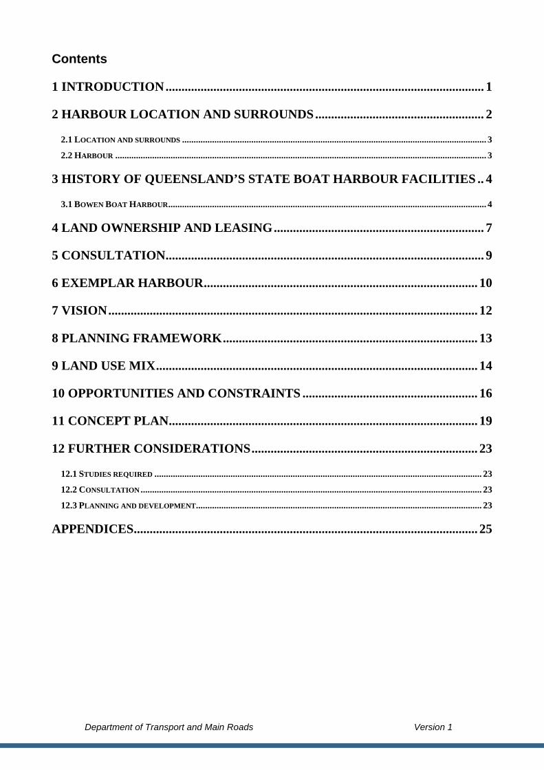
2.1 Location and surrounds
The Bowen Boat Harbour is located 1.2 kilometres north-east of the Bowen central business district (CBD).
Bowen is home to approximately 10 260 people, with a median age of 39, living in predominately detached
dwellings2.
The harbour is accessible via a 3-minute car or public transport trip from the Bowen CBD. Bus services are
provided directly outside the harbour, on Santa Barbara Parade.
The northern edge of the harbour borders Magazine Creek and Denison Park, north of Peter Wyche Drive.
The western edge of the harbour abuts the CBD, a caravan park, the jetty and Santa Barbara Park. Port
Denison is to the south and Flagstaff Hill Lookout, Dalrymple Point and the Coral Sea to the east.
2.2 Harbour
The harbour provides marine access to Port Denison and the Coral Sea through its public and private boat
ramps and is a popular destination for tourists, recreational fishers and boating club members. The harbour
includes:
• vacant spoil land and Magazine Creek to
the north;
• a public boat ramp with ample car and
trailer parking; the yacht club; and vacant
land, which are accessible from Starboard
Drive, to the south;
• vacant spoil land and vegetation to the
east; and3
• a slipway and marina; seafood receivals
Volunteer Marine Rescue, which are
accessible from Henry Darwen Memorial
Drive, to the west.
2 Australian Bureau of Statistics 2012, 2011 Census of Population and Housing - Bowen Basic Community Profile –
Based on Place of Usual Residence, Catalogue No. 2001.0
3 Google 2013, Google Maps, viewed 29 April 2013, www.maps.google.com.au
Figure 2: Bowen Boat Harbour Locality Map3

Department of Transport and Main Roads Version 1 Page 4
3 HISTORY OF QUEENSLAND’S STATE BOAT HARBOUR FACILITIES
Boating and boating-based tourism has always been a popular pastime for Queenslanders and visitors. By the
1960s, this popularity resulted in inadequate, inaccessible and unsafe moorings, berths, boat ramps, havens
and the facilities across Queensland. In response, the Queensland Government assumed responsibility for the
construction and maintenance of small craft havens, jetties and launching ramps in the early 1960s.
3.1 Bowen Boat Harbour The Bowen Harbour Board Act came into force in 1914 and defined the limits of the harbour of Bowen as –
‘the area comprised within a line commencing at Cape Edgecumbe, and proceeding to Cape Gloucester;
then by the mainland to the point of commencement, including all rivers, creeks, and navigable waters within
that area’.
The harbour included the original Port Denison jetty which was built out to 12 feet of water at low tide in
1865-66. The jetty has supported a range of primary industries over the years, including sugar, cotton and
coal.
In the late 1940s, the Bowen Town Council decided to investigate a proposal for a new boat harbour to cater
to tourists, fishing and pleasure craft. A small boat harbour was eventually constructed at the end of Santa
Barbara Parade and the mouth of Magazine Creek. It is this State-owned small boat harbour which is the
subject of this concept planning process.
Figure 3 illustrates a view of the site in the 1920s, before harbour construction commenced. Figure 4
provides a view of the boat harbour in 1966.

Department of Transport and Main Roads Version 1 Page 5
Figure 3: Aerial view of Bowen Harbour, circa 19274
Figure 4: Bowen Harbour, circa 19665
4 Aerial view of Bowen and Harbour, ca 1927, viewed 29 April 2013
http://onesearch.slq.qld.gov.au/primo_library/libweb/action/dlDisplay.do?vid=SLQ&docId=slq_digitool431546
5 Queensland and Places, viewed 29 April 2013
http://queenslandplaces.com.au/sites/queenslandplaces.com.au/files/imagecache/watermarked/exhibits/slides/LBC064.j
pg

Department of Transport and Main Roads Version 1 Page 6
In the mid 2000s, the JAG Marina Group Pty Ltd prepared a master plan for the entire harbour. The master
plan envisaged a range of uses within the harbour, including residential; mixed use including retail, tourism
and commercial; marina services and industry; and wet marine facilities. The master plan was endorsed in
principle by the department and the proponent commenced obtaining the necessary planning and
environmental approvals. However, the development of the master plan did not proceed.

Department of Transport and Main Roads Version 1 Page 7
4 LAND OWNERSHIP AND LEASING
The State of Queensland owns all the land and seabed within the harbour that is described as Lot 310 on SP
198022 and is approximately 55.5 hectares in area. TMR, representing the State, leases part of the State-
owned land and seabed to a range of organisations for uses including sea rescue operations, boat/ yacht
clubs, marina activities and fishing vessel moorings/ berths. These current uses are detailed in Figure 5.

Department of Transport and Main Roads Version 1 Page 8
Figure 5: Current leasing arrangements – Bowen boat harbour
Wet marine Wet marine
Community and club organisation
Dry marine Community and club organisation Dry marine
Dry marine
Recreational facility

Department of Transport and Main Roads Version 1 Page 9
5 CONSULTATION TMR facilitated a workshop with representatives from the organisations and individuals occupying the
harbour and the local government on 10 April 2013. Representatives included Whitsunday Regional Council;
boat/ yacht clubs; sea rescue operators; marine industrial services and a fish receival service provider.
The workshop gathered input and feedback to develop a vision for the harbour; describe the harbour’s
opportunities and constraints; and determine an appropriate land use strategy. The workshop included an
overview of the existing harbour; the local government planning context; and a best-practice example of an
Australian harbour, Hillarys Boat Harbour in Western Australia. The outcomes of the workshop are provided
in the Appendices.
The information gathered from this workshop has been used to inform the vision and land use objectives of
this Concept Plan.

Department of Transport and Main Roads Version 1 Page 10
6 EXEMPLAR HARBOUR
Hillarys Boat Harbour is located within the suburb of Hillarys, 18 kilometres north-west of Perth, Western
Australia. It was built in the mid 1980s in preparation for Australia’s defence of the America’s Cup yacht
race6. Figures 6 and 7 illustrate an aerial and perspective view of the harbour.
Figure 6: Aerial photograph of Hillarys Boat Harbour7
Figure 7: Hillarys Boat Harbour at dusk8
Hillarys Boat Harbour has been used as an exemplar to inform this concept planning exercise because it
champions many medium and long-term best-practice outcomes that are aspired to for the Bowen Boat
Harbour. In particular, Hillarys Boat Harbour has successfully integrated with the community, increased
tourism, economic sustainability and the grouping of like uses.
6 Western Australian Department of Transport 2012, Hillarys Boat Harbour, viewed 12 November 2012,
http://www.transport.wa.gov.au/imarine/19385.asp
7 Google 2012, Google Maps, viewed 11 November 2012, www.maps.google.com.au
8 Part of Kirk Hill 2001, Hillary Sunset, viewed 2 November 2012,
http://www.transport.wa.gov.au/mediaFiles/mar_PictureThisHillarysPhotoCompWin2011.pdf

Department of Transport and Main Roads Version 1 Page 11
Integrated with the community: Hillary’s Boat Harbour is a popular destination for the residents of Perth.
The harbour has direct links to the surrounding community though a well connected road network. It
supports numerous community uses including an education centre, a protected swimming beach, recreational
facilities and a variety of profitable cafes, restaurants and bars.
Tourism: The harbour is Western Australia’s busiest recreational harbour, catering for more than 700
vessels and in excess of four million visitors each year9. It caters for charter vessels, with trips to Rottnest
Island. The harbour also hosts antique fairs, a triathlon and various exhibitions.
Economic sustainability: The harbour is an important part of the northern suburbs of Perth, with its
commercial operations providing an economic contribution to Western Australia and appealing to families,
making it a popular meeting place for the local community. There are 800 people employed at Hillary Boat
Harbour. The economic turnover of Western Australian Marinas is projected to increase by 40% over the
next 5 years10.
Grouping of like uses: The harbour groups like uses together, including wet marina uses to the north,
commercial/ charter uses to the south and tourist-related uses to the east as depicted in Figure 8. This
grouping of like uses increases the legibility of the harbour as a destination; contributes to economic viability
centralising business; and allows for the separation of incompatible uses that may affect amenity.
Figure 8: Grouping of uses within Hillarys Boat Harbour11
9 Western Australian Department of Planning and Infrastructure 2008, Ministerial Statements, Hillarys boat harbour
named best marina in WA 24/1/08
10 Helen Crips n.d, Report on the Western Australian Marine Industry, Australian Edith Cowan University, Perth
11 Modified from Hillarys Boat Harbour n.d. Hillarys Boat Harbour, viewed 8 November 2012,
www.hillarysboatharbour.com.au/pdf/hillarys_map.pdf

Department of Transport and Main Roads Version 1 Page 12
7 VISION
Workshop attendees participated in an exercise to identity keywords to describe their vision of an ideal boat
harbour. Once the workshop attendees had identified the keywords, they voted on these words. Through this
process, the keywords were ranked from most popular to least popular. These rankings and along with the
draft vision statements are shown in Appendix A.
The following word cloud illustrates the words workshop attendees considered the most important words to
the vision of the harbour. Words that appear larger received a greater proportion of votes than the words that
appear smaller.
Figure 9: Vision word cloud
From the above words, three potential vision statements were created. These can be found in Appendix A. Of
the three, the following vision for the Bowen boat harbour was deemed the most appropriate.
Bowen Boat Harbour is an economically viable working
harbour. It is a safe, vibrant and attractive destination for the local community and tourists. The harbour showcases local produce and provides efficient marine and recreation access to the public and industry.
12 13 22 23
12 Experience Perth n.d, viewed 15 November 2012, http://www.experienceperth.com/destinations/fremantle
13 Protectora de Inmuebles n.d, viewed 15 November 2012,www.protectoradeinmuebles.com/ingles/home.html

Department of Transport and Main Roads Version 1 Page 13
8 PLANNING FRAMEWORK An extensive planning framework at the local, state and national level influences the development potential
of the harbour.
Local governments control development through the zonings, codes and desired outcomes of their planning
schemes under the Sustainable Planning Act 2009. This includes the Bowen Shire Council Planning Scheme
2006 administered by Whitsunday Regional Council.
The State Government also controls development through its role assessing the potential impact of
development proposals on the objectives of the State. Of particular importance to development proposals in
the harbour will be the State’s objective to protect ecological processes and biodiversity, heritage values and
the safe and efficient operation of the State infrastructure.
The Commonwealth Government also controls development to ensure development proposals will not
compromise a matter of national environmental significance under the Environmental Protection and
Biodiversity Conservation Act 1999.
Consequently, any development applications within the harbour will be subject to assessment and approval
by a combination of local, state and potentially national government bodies against numerous plans and
policies.
This Concept Plan does not influence the level of assessment or suitability of development proposals within
the harbour, but may influence future local government planning activities over the harbour site.
1415
14 Experience Perth n.d. viewed 15 November 2012, www.experienceperth.com/destinations/sunset-coast
15 Oyster Bay Harbour and Yacht Club n.d. viewed 15 November 2012, http://oysterbayharbour.com/oyster-bay-
community/wildlife/

Department of Transport and Main Roads Version 1 Page 14
9 LAND USE MIX
Identifying and co-locating like activities and land uses can promote a sustainable and viable harbour. In
recognition of this, workshop attendees were asked to identify and define activities and uses they perceived
as appropriate to a harbour.
Workshop attendees were asked to consider the spatial relationship land uses had to each, the surrounding
community and Port Denison/ Coral Sea. In particular, workshop attendees consider what uses benefit from
being located near each other, and therefore are compatible; and what uses could or should not be located
near each other, and therefore are incompatible.
These land uses have been standardised against the common town planning land uses used in planning
schemes and the land uses present within other harbours to develop a single set of land uses for use in this
Concept Plan. This set of potential land uses is listed in Table 1 on the following page with the workings
from contained in Appendix B.
The spatial relationships between land uses were crucial considerations when determining an appropriate
medium and long-term land use mix for the Bowen Boat Harbour.

Department of Transport and Main Roads Version 1 Page 15
Table 1: Potential Bowen Boat Harbour land uses and activities
Marine facilities • Wet marine
o Recreational boat moorings and berths
o Live on-board moorings and berths
o Commercial moorings and berths Tourism Fishing Charter – boat hire Barge
• Dry marine o Mechanical/ electrical
services o Spray painting/ welding o Boat builders, sail
makers, marine trimmers o Travel lift o Slip yard o Fuelling facilities o Dry storage
Boatyard Stack storage General storage
o Commercial fish receivals Food distribution
and processing Cold storage
• Supporting marina facilities o Chandlery o Bait and ice supplies o Convenience store/ café o Showers and toilets o Rubbish collection,
sewage disposal o Harbour management
offices o Car parking
Community and club organisations • Volunteer Marine Rescue • Police/ customs/ border
protection
• Navy Cadets • Sailing clubs • Aquatic clubs
• Training schools/ TAFE • Training facilities
Open space and recreational facilities • Parks • Swimming pool and bathing
reserves • Picnic, BBQ and family
places • Water sports, beach landing
• Toilets/ change facilities • Bike path and pedestrian
facilities
• Recreational boating o Boat ramp o Trailer parking o Pontoons o Fish cleaning and wash-
down areas
Retail, hospitality and tourism • Restaurant/ bistro/ cafe • Clubs, licensed premises • Takeaways • Fish monger
• Retail shopping • Function facilities
• Tourism o Booking offices
Information Event management Charter services Boat hire
Mixed-use development • Retail/ shop
• Short-term accommodation
• Residential up to three storeys
Department of Transport and Main Roads Version 1 Page 16
10 OPPORTUNITIES AND CONSTRAINTS
Workshop attendees were asked to identify the opportunities and constraints applicable to the harbour on
aerial photographs and in writing. These opportunities and constraints were used in conjunction with the
Concept Plan team’s own observations from the discussions at the workshop to inform the concept planning
process and guide the establishment of a preferred land use mix. The results of this workshop exercise are
shown in the Appendices.
Opportunities and constraints for the harbour are illustrated in Figures 10 and 11.

Department of Transport and Main Roads Version 1 Page 17
Figure 10: Opportunities - Bowen boat harbour
Vacant land
Create a rock pool
Higher vacant land Depth of water for
moorings
Potential to construct a
pedestrian connection
Extend Council
streetscape
beautification
Construct rock
walls to create a
beach
Extend rock wall Dredge/ excavate
harbour entrance
and channel depth
Group similar
activities in one
precinct
Create open space
with pedestrian
paths along the
water’s edge
Create an entry
statement to the
harbour

Department of Transport and Main Roads Version 1 Page 18
Figure 11: Constraints - Bowen boat harbour
Possible contaminated
land as former rubbish
dump
Costs to construct
services/ infrastructure
Strong currents Entrance to harbour at
low tide
South-east winds
A rock wall is required to
facilitate a pontoon
Consider new
infrastructure
requirements
Need to expand slipway
Storm surge and flooding
Capital required for
redevelopment
Leasing timeframes may
affect staging/
redevelopment
Environmental constraint

Department of Transport and Main Roads Version 1 Page 19
11 CONCEPT PLAN
The boat harbour has been divided into the six land uses to form a Concept Plan. These land uses include:
• Marine facilities;
• Community and club organisations;
• Open space and recreational facilities;
• Retail/ hospitality and tourism;
• Mixed-use development; and
• Vegetative buffer.
Section 9 Land Use Mix lists the activities these land uses support.
The Bowen Boat Harbour Concept Plan is illustrated on the following page. It combines the outcomes
developed by the stakeholders at the workshop. This combined concept plan is an ultimate and long term
plan, utilising all developable land in the harbour. This long term plan may provide a concept beyond 30
years. The harbour is made up of four geographical precincts:
• Northern precinct;
• Eastern precinct;
• Starboard Drive precinct; and
• Henry Darwen Memorial Drive precinct.
Figure 12 – Concept plan precincts

Department of Transport and Main Roads Version 1 Page 20

Department of Transport and Main Roads Version 1 Page 21
Northern precinct
There is an opportunity for the northern precinct to become the working part of the harbour. The primary use
will be dry marine activities, supported by supplementary wet marine uses. The potential to excavate land in
the north-west of the precinct may increase the harbour’s boating capacity and access to the water. There is
an opportunity to reconfigure the existing mornings in this northern part of the harbour to increase mooring
and berthing capacity and improve access.
The entrance to the northern precinct will be via a new access point from Peter Wyche Drive. Signage should
be incorporated at the Hay Street/ Peter Wyche Drive roundabout to direct employees, visitors and industry
to the northern precinct. In addition, there is an opportunity to create a gateway sign at the entrance of the
precinct.
Eastern precinct
In the long-term, the eastern precinct will contain the public boat ramp, community and club facilities and
dry marine activities. The public boat ramp is strategically located close to the harbour entrance and is
separated away from the wet marine activities. An area of spoil land at the entrance of the harbour may be
excavated to increase the width of the harbour entrance and improve water access.
A new road will be constructed for this precinct which will be accessible via Peter Wyche Drive. Improved
signage should be provided at strategic locations around the harbour to direct people to the boat ramp
facilities and the other uses in the eastern precinct.
Starboard Drive precinct
The Starboard Drive precinct will connect with the centre of town and the recreational foreshore along Santa
Barbara Parade. This precinct will be known as a place for tourism, recreation and enjoying the views.
Land uses to support this objective will include retail/ hospitality and tourism, mixed use development,
community and club facilities, and open space and recreational facilities. There is an opportunity to develop
a retail/ hospitality/ tourism key attractor at the corner of Santa Barbara Parade and Starboard Drive. Open
space and recreational facilities will be located along the entire length of the southern portion of the precinct
as well as connecting the recent foreshore redevelopment along Santa Barbara Parade and up to the
roundabout. The inclusion of rock walls may over time create sandy beaches for local and tourists to enjoy.
The wet marine facilities will be redesigned to maximise safe access and movement as well as potentially
increase the mooring/ berthing capacity.
Improved signage from Santa Barbara Parade will direct visitors and locals to the precinct. Improvements to
the road may be required to facilitate safe access to the land uses in the precinct.

Department of Transport and Main Roads Version 1 Page 22
Henry Darwen Memorial Drive precinct
The Henry Darwen Memorial Drive precinct will feature mixed use development. The precinct will be
anchored by retail/ hospitality and tourism at the roundabout. Further investigations will need to be
undertaken to ensure the site is suitable for development and is remediated from contaminants.
The mixed use precinct will be complemented by community and club facilities at one end of the precinct
and open space and recreational facilities at the other end. The community and club facilities will have direct
access to wet marine activities. The open space and recreational facilities will provide an opportunity to
capture the harbour views and be accessible to the public.
Signage and a reconfigured road in this precinct will make it easy to access and inviting to locals, harbour
employees and visitors.

Department of Transport and Main Roads Version 1 Page 23
12 FURTHER CONSIDERATIONS
12.1 Studies required Realisation of the short, medium and long-term land use objectives of this Concept Plan will depend upon a
variety of further technical studies. These technical studies are necessary to critique the feasibility, safety,
cost effectiveness, appropriateness and overall impact of the Concept Plan’s objectives. These studies
include, but are not limited to the following:
• a traffic impact assessment;
• an environmental impact assessment (considering storm surge, storm tide erosion and flora and
fauna);
• a survey report;
• a hydro graphic survey report (considering tidal flows, diversion channel use);
• an engineering report for major works;
• a dredging feasibility and spoil strategy study;
• an economic assessment report;
• a geotechnical report; and
• a future boat ramp location and access analysis report.
The outcomes of these studies will inform and update the objectives of this Concept Pan.
12.2 Consultation TMR facilitated a workshop on 10 April 2013 to consult with harbour lessees and local government
representatives to inform the preparation of this Concept Plan. Wider community consultation has not
occurred at this stage given the Concept Plan is preliminary in nature and the realisation of the plan is
dependant on further technical studies and development interests from lessees and private enterprise.
12.3 Planning and development
This Concept Plan is a guiding tool for future leasing arrangements and a vision for future development in
the harbour. This Concept Plan does not provide development approval and therefore; proposals for
development in the harbour may require approval by the local government depending on their scale.
Development applications are assessed against the relevant local government’s planning scheme in
accordance with the Sustainable Planning Act 2009. Section 8 provides further information on the planning
framework. For example, the Bowen Boat Harbour is located on the coast and may be susceptible to coastal
hazards such as storm surges and tidal inundation. Proponents of future development proposals within the

Department of Transport and Main Roads Version 1 Page 24
harbour may be required to undertake environmental investigations in order to understand and then mitigate
the impact of these coastal hazards. In addition, development proposals may need to mitigate the adverse
impact they may have on the amenity of surrounding uses.

APPENDICES Appendix A: Workshop vision exercise Appendix B: Workshop land use mix exercise Appendix C: Workshop visual notes - including opportunities
and constraints

Appendix A: Workshop vision exercise Word No. of votes
Economically viable 22
Local produce including seafood, tomatoes, mangos and other local fruit and vegetables 15 Vibrant and attractive 10 Connecting foreshore to marina 9 Seafood, cinema and beaches 9 Employment and investment 8 Integrated with the Central Business District 8 Sustainable 8 Tenure security 8 Residential hub and community 7 Working harbour 7 Public access 6 Safe haven for local boat owners 6 Accommodation 5 Safe access from water 5 Safe haven to attract cruising vessels 5 Celebrate the lifestyle 4 Liveable 4 Support the Central Business District 4 Support the local community 4 Scenic 3 Tourism 3 User friendly 3 Active and interactive 2 Discoverability with the use of Trip Advisor 2 Family-friendly 2
Hidden gem showcasing dugongs, whales and coastal driving 2 Industry 2 Linkages 2 Visitors 2 Compatible uses 1 Educational 1 Opportunity for tourism and industry growth 1 Partnerships 1 Point of difference 1 Profitable 1 Recreational water activities 1 Turquoise 1 Access to the islands 0 Attractor 0 Authentic 0

Commercial 0 Food 0 Foreshore 0 Fun 0 Marketable 0 Maximise views (360 degrees) 0 Multi-purpose 0 Practical 0 Retail 0 Security 0 Suitable 0 Yacht clubs 0
Vision statement
From the above words, three vision statements were developed. They are as follows:
1. Bowen Boat Harbour is an economically viable working harbour. It is a safe, vibrant and attractive
destination for the local community and tourists. The harbour showcases local produce and provides
efficient marine and recreation access to the industry and public.
2. Bowen Boat Harbour is an attractive tourist destination and is a vital part of the surrounding
community. It is sustainable, safe and provides efficient access to all recreation and marine uses.
3. Bowen Boat Harbour provides economic security to the marine industry through investment and
employment. The harbour is integrated with the foreshore enabling community and visitors to ability
to recreate and enjoy the harbour.

Appendix B: Workshop land use mix exercise Group A
Marine facilities
Recreational boat moorings and berths Tourism – dive (not in harbour) Fishing – on demand Spray painting/ welding Travel lift – trolley Slip yard Fuelling facilities Dry storage – only with boat club membership Commercial fish receivals – food distribution and processing Chandlery – small Shower, toilet Rubbish collection Harbour management offices Information centre – in town Car parking
Community and club organisations
Volunteer Marine Rescue Customs – in town Sailing clubs – NGCYC
Open space and recreational facilities
Parks Car parking Boat ramp Trailer parking – 118 Pontoons
Retail, hospitality and tourism
Restaurant – in yacht club Clubs Fish monger Function facilities – club (100 people and on lawn) Charter services Boat hire
Group A
Short term 1-10 years
Marine facilities
Charter boat facilities/ tourism (short to medium term) Maintenance on pile moorings Walk up moorings Expansion of existing marina berths Ship wrights Travel lift (100t) and more hard stand space (point of difference) Sewerage disposal Convenience story (resupply)

Community/ tourism
Take away food Parks and BBQ’s Foreshore extension (bike and pedestrian paths extended) Clean and tidy up Promote small boat sailing
High priority
Extend rock wall Dredge/ excavation harbour entrance and channel depth
Group B Land uses
In Out
Boat/ sail repairs Ferry services
Residential and short-term accommodation Stack storage (?)
Group supporting uses in one space e.g. dry
marine
Special interest clubs (?)
All wet marine Water sports
Community
VMR/ customs TAFE/ training facilities
Swimming pool
Open space Aquarium
Fish cleaning Discovery centre (?)
Retail
Group B
Works well
Car parks and slipways Jetty (public) Fishing Yacht club marina Road access
Not so well
Slipway – need to expand Extend wall Improve leeds and channel Dredging Need to fully utilise second basin Pedestrian paths – connect to foreshore Clean the end of the street up – make it greener – create an entry statement
Group C What’s in a harbour?
Marine facilities
Add ‘barge’ to ‘commercial moorings’ Add ‘live fish’ under ‘commercial fish receivals’ Add ‘manufacturing’ to ‘food distributions and processing’ under ‘commercial fish receival’

Add after ‘convenience store’, ‘café’
Community and club organisations
Training – add TAFE Spelling ‘boarder’
Open space and recreational facilities
Add ‘swimming pools’ and ‘bathing reserve’ Remove ‘car parking’
Retail, hospitality and tourism
Under tourism, add ‘memorials’ as a new dot point
Mixed use development
Change ‘retail’ first and ‘residential’ second Add ‘up to three storeys residential’ Res R2 Freehold potential

Grouped land use and activities against town planning definitions
Workshop outcomes Planning definition/ land use equivalent
Wet marine
Boat ramp/ public access/ pontoons/ car and trailer park Landing that is for all encompassing users – families, persons with disabilities (PWD) and boaties Public and commercial boat ramps/ facilities, public moorings Pontoons (recreational/ commercial) Jetties Marinas (live-a-boards)/ live aboard accommodation Marina berths, mooring facilities/ large boat moorings Commercial berths/ boat pens
Landing and car park
Open space
Parkland/ public space open space/ landscaping Recreational facilities/ family places Amenities – BBQ, fish gutting table, shelters, toilets/ showers, water
Park
Retail, tourism and commercial
Ship broker Bait/ tackle/ ice supplies Dive shop Retail/ shopping Convenience shop/ supplies Associated commercial development – shops
Shop
Charter boat - tourist operations/ mooring/ ticketing/ ferry/ commercial Small boat hire Trawlers/commercial fishing
Port services, shop and landing
Harbour management Information centres
Office/ shop
Tourism (including retail), attractions (e.g. aquariums) Tourism/ eco tourism – combined use of QPWS facility to promote tourism and marine education Tourist attractions/ theme park Marine discovery/ education centre
Tourist park
Events –markets Market
Events – boat show event facilities Training facilities – conference convention centre
Function facility
Restaurants/bistro/café Food and beverage Integrated hospitality
Food and drink outlet

Short term/ stay accommodation Residential/ accommodation
Short-term accommodation
Marine industrial
Fuel/ fuelling facilities/ re-fuelling station Boating services/ maintenance facilities/ shipwrights mechanics, marine electrician/ sail maker/ marine trimmer Chandlery/ ship yard Pump out facilities/ hazardous transfers Dry storage/ rack storage/ hardstand storage/ marine/ boat storage Slipways/ travel lifts
Marine industry
Heavy/ industrial – welding, spray painting Medium impact industry
Seafood/ fish receivals Food distribution/processing
Medium impact industry
Community and club organisations
Emergency/ VMR/ coastguard Police, boat licensing facilities (2) Government facilities – DERM, DPI Customs/ border protection
Emergency services
Aquatic clubs/ sailing clubs/ boat/ yacht clubs – ramps, hall, rigging lawn Water sports Special interest clubs
Club (and landing)
Training facilities Cadets/ training schools Training facilities marine
Educational facility

Appendix C: Workshop visual notes - including opportunities and constraints