Embed Size (px)
Citation preview
Boundary Project: Geochemistry of Volcanic Rocks of the WallaceFormation, Beaverdell Area, South-Central British Columbia
(NTS 082E/06E, 07W, 10W, 11W)
by N.W.D. Massey
KEYWORDS: Quesnellia, Tri as sic, Wallace For ma tion,Beaverdell, calcalkaline
INTRODUCTION
The Bound ary Pro ject was ini ti ated in 2005 with thepur pose of better char ac ter iz ing the lithological and geo -chem i cal vari a tions within and be tween the var i ous Pa leo -zoic se quences in the south ern Okanagan re gion along theAmer i can bor der (Massey 2006, 2007; Massey and Duffy2008a). Pre-Ju ras sic rocks in the Beaverdell area were as -signed by Reinecke (1915) to the ‘Wallace Group’ (sin glequo ta tion marks are used to high light the ac tual term usedin the pa per) and cor re lated, in part, with Pa leo zoic se -quences to the south, in clud ing the An ar chist schist and theAtt wood ‘se ries’. Lit tle (1957, 1961) and Tempelman-Kluit (1989a, b) ex tended this work to the east and west in -clud ing these rocks in the ‘Anarchist Group’.
The pre-Ju ras sic rocks of the Beaverdell area (Fig -ure 1), how ever, dif fer sig nif i cantly from the type An ar -chist schist to the south (Massey and Duffy, 2008a). Theyare dom i nated by fine- to me dium-grained clastic sed i men -tary rocks that are es sen tially unmetamorphosed, thoughthey do show ex ten sive hornfelsing from Ju ras sic plutons.Lime stone and greenstone mem bers oc cur in the CrouseCreek area, and are stratigraphically the low est ex posedunits. Sig nif i cantly, there is no chert de vel oped in the se -quence. No pen e tra tive de for ma tion was ob served, ex ceptfor one small area, to the west of Crouse Creek.
Massey and Duffy (2008a) pro posed to re vert toReinecke’s orig i nal ter mi nol ogy of ‘Wallace’ for theserocks, though at the for ma tion level rather than the grouplevel. It should be noted, how ever, that not all of the areaorig i nally mapped as Wallace by Reinecke (1915) is ac tu -ally un der lain by pre-Ju ras sic rocks—there is a sig nif i cantamount of youn ger in tru sive ma te rial. In par tic u lar, manyrocks mapped as so-called pyroxene-phyric vol ca nic rocksin Reinecke’s Wallace are ac tu ally por phyry dikes of Ter -tiary age, and in one area, east of Col lier Lake, pyroxene-phyric flows of the Eocene Marron Formation.
No geo chron ol ogi cal or paleontological data are cur -rently avail able for the Wallace For ma tion rocks and cor re -la tion is there fore dif fi cult. As stated above, it is litholog -ically dis sim i lar to any of the Pa leo zoic se quences to the
south. It does, how ever, show some sim i lar i ties to parts ofthe Mid dle–Late Tri as sic Brook lyn For ma tion of theGreen wood area (Fyles, 1990) or the Frank lin Camp,though lack ing the dis tinc tive basal sharpstone con glom er -ate, pos si bly due to a lack of ex po sure. The Wallace For ma -tion is in truded by the West Ket tle batholith, now known tobe of Late Triassic age (Massey et al, 2010).
WALLACE FORMATION
The low est ex posed unit in the Wallace For ma tion isthe Larse Creek lime stone mem ber. Con tact with the over -ly ing greenstone mem ber is not ex posed, but the lime stoneis es ti mated to be at least 100 m thick. It is grey on weath -ered sur faces, vary ing from black to grey to white on freshsur faces. It is mas sive to well bed ded and lam i nated. Thinsi li ceous and mi nor calcsilicate veins weather with pos i tive re lief. Macrofossils are ab sent and cono donts have not been recovered to date.
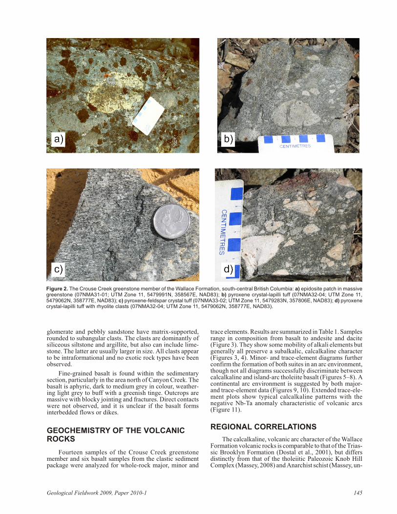
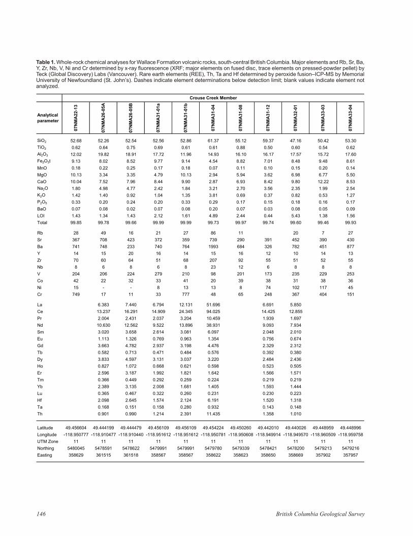
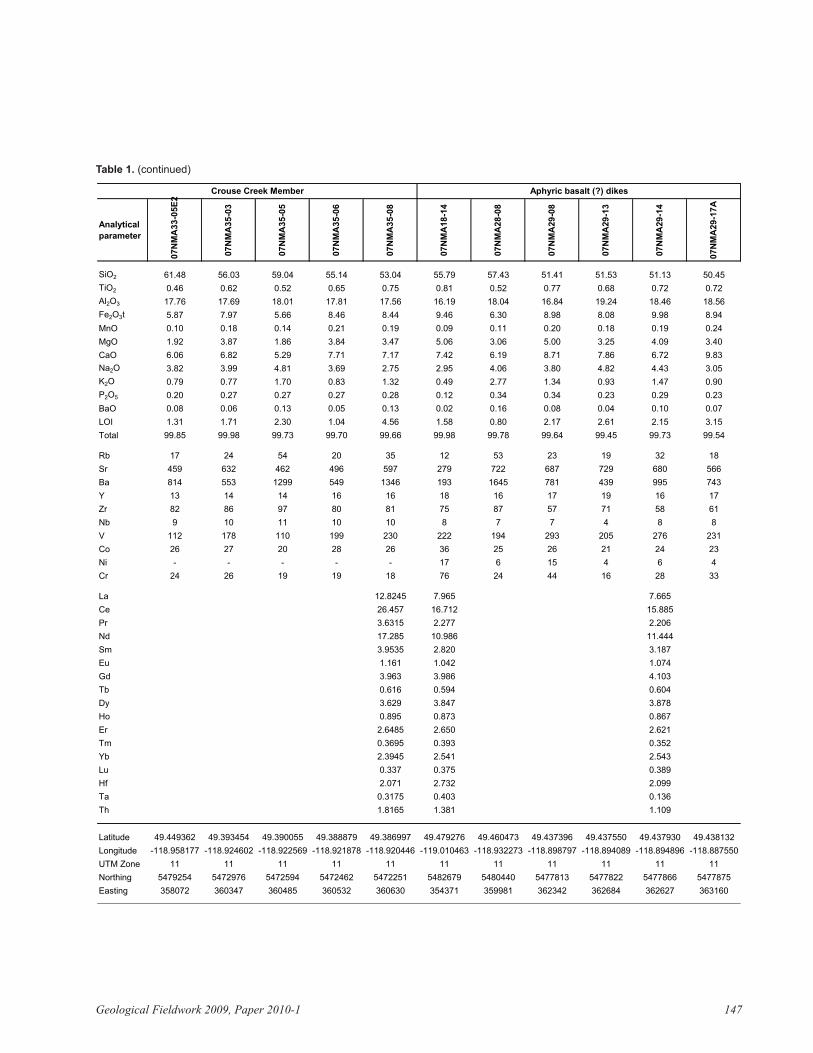
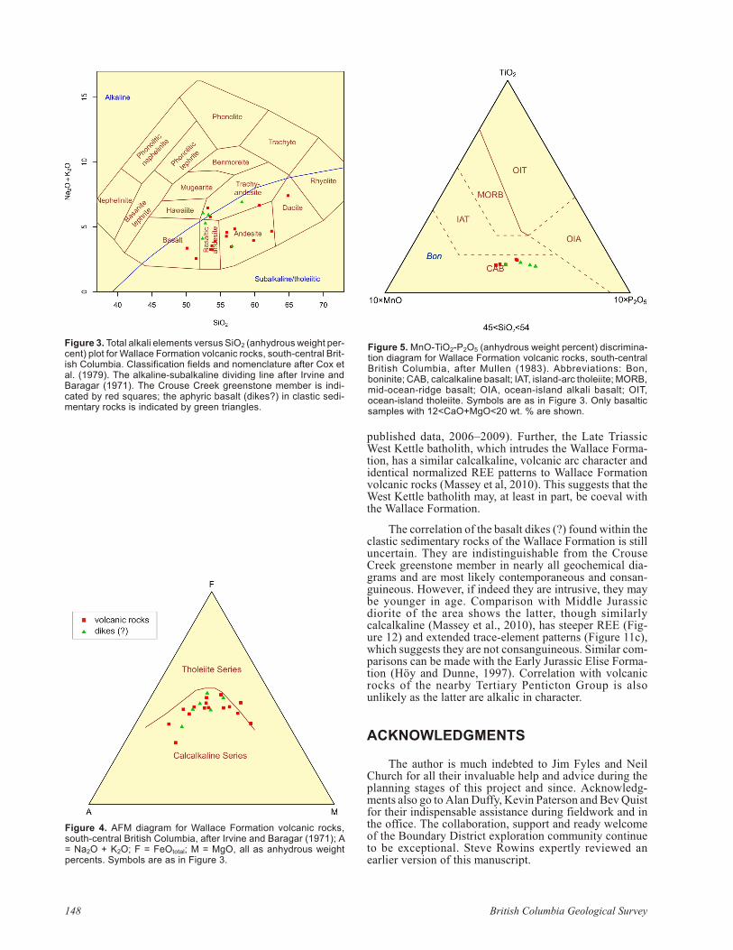
The Crouse Creek greenstone mem ber over lies thelime stone mem ber. This unit com prises mostly mas sivemafic flows, though amygdules are not un com mon. Theflows are me dium to dark green-grey, blu ish green or blackin col our. They may show bright green epidosite patches upto 30 cm across (Fig ure 2a) and veins of quartz–chlorite±epidote±cal cite. Many flows are fine-grained andaphyric, but feld spar-phyric and pyroxene-feld spar–phyric flows are also com mon. Pheno crysts are 1–2 mm in size.Vol ca nic brec cia, lapilli tuff, pyroxene lapilli tuff or chlor -itic metatuff (Fig ures 2b–d) and mi nor lam i nated lime stoneare found interbedded in the flows. Some vol ca nic brec ciasalso con tain lime stone and clastic sediment clasts.
Most of the ex posed Wallace For ma tion is typ i callyinterbedded and lam i nated siltstone and argillite. Siltstonebeds are light buff to pale grey in col our, whereas theargillite is dark grey. Weath ered sur faces may be bro kenwith a coat ing of rusty ox ides. In di vid ual beds can range upto 3 cm thick with lami na tions of ~1–2 mm. The sed i men -tary rocks are of ten si li ceous or porcelaneous and may berecrystallized due to hornfels de vel op ment by Tri as sic andJu ras sic in tru sions. Oc ca sional white, tan or grey lime stone interbeds vary from sev eral centi metres up to five metresthick. The lime stone is mas sive and may be recrystallizeddue to the de vel op ment of hornfels or variable silicificationand skarn.
Coarser clastic beds are also found, though less com -mon than the siltstone-argillite interbeds. Sand stone bedsare grey, me dium to coarse grained, and gen er ally mas sive.Hornfelsed sand stone is recrystallized to feld spar-quartz-am phi bole as sem blages that can be dif fi cult to dis crim i natefrom microdiorite or microgranodiorite in the field. Con -
Geo log i cal Field work 2009, Pa per 2010-1 143
This pub li ca tion is also avail able, free of charge, as col ourdig i tal files in Adobe Ac ro bat® PDF for mat from the BCMin is try of En ergy, Mines and Pe tro leum Re sources website athttp://www.empr.gov.bc.ca/Mining/Geoscience/PublicationsCatalogue/Fieldwork/Pages/default.aspx.

144 Brit ish Co lum bia Geo log i cal Sur vey
Fig ure 1. Ge ol ogy of the area east of Beaverdell, south-cen tral Brit ish Co lum bia (af ter Massey and Duffy, 2008b). The ex tent of col ouredpoly gons shows the limit of the area mapped in 2007.
glom er ate and peb bly sand stone have ma trix-sup ported,rounded to subangular clasts. The clasts are dom i nantly ofsi li ceous siltstone and argillite, but also can in clude lime -stone. The lat ter are usu ally larger in size. All clasts ap pearto be intraformational and no ex otic rock types have beenobserved.
Fine-grained ba salt is found within the sed i men tarysec tion, par tic u larly in the area north of Can yon Creek. Theba salt is aphyric, dark to me dium grey in col our, weath er -ing light grey to buff with a green ish tinge. Out crops aremas sive with blocky joint ing and frac tures. Di rect con tactswere not ob served, and it is un clear if the ba salt formsinterbedded flows or dikes.
GEOCHEMISTRY OF THE VOLCANICROCKS
Four teen sam ples of the Crouse Creek greenstonemem ber and six ba salt sam ples from the clastic sed i mentpack age were an a lyzed for whole-rock ma jor, mi nor and
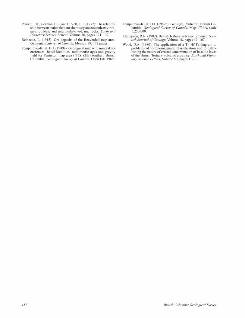
trace el e ments. Re sults are sum ma rized in Ta ble 1. Sam ples range in com po si tion from ba salt to an de site and dacite(Fig ure 3). They show some mo bil ity of al kali el e ments butgen er ally all pre serve a subalkalic, calcalkaline char ac ter(Fig ures 3, 4). Mi nor- and trace-el e ment di a grams fur thercon firm the for ma tion of both suites in an arc en vi ron ment,though not all di a grams suc cess fully dis crim i nate be tweencalcalkaline and is land-arc tholeiite ba salt (Fig ures 5–8). Acon ti nen tal arc en vi ron ment is sug gested by both ma jor-and trace-el e ment data (Fig ures 9, 10). Ex tended trace-el e -ment plots show typ i cal calcalkaline pat terns with thenegative Nb-Ta anomaly characteristic of volcanic arcs(Fig ure 11).
REGIONAL CORRELATIONS
The calcalkaline, vol ca nic arc char ac ter of the WallaceFor ma tion vol ca nic rocks is com pa ra ble to that of the Tri as -sic Brook lyn For ma tion (Dostal et al., 2001), but dif fersdis tinctly from that of the tholeiitic Pa leo zoic Knob HillCom plex (Massey, 2008) and An ar chist schist (Massey, un -
Geo log i cal Field work 2009, Pa per 2010-1 145
Fig ure 2. The Crouse Creek greenstone mem ber of the Wallace For ma tion, south-cen tral Brit ish Co lum bia: a) epidosite patch in mas sivegreenstone (07NMA31-01; UTM Zone 11, 5479991N, 358567E, NAD83); b) pyroxene crys tal-lapilli tuff (07NMA32-04; UTM Zone 11,5479062N, 358777E, NAD83); c) pyroxene-feld spar crys tal tuff (07NMA33-02; UTM Zone 11, 5479283N, 357806E, NAD83); d) pyroxenecrys tal-lapilli tuff with rhy o lite clasts (07NMA32-04; UTM Zone 11, 5479062N, 358777E, NAD83).
146 Brit ish Co lum bia Geo log i cal Sur vey
Analytical
parameter
07N
MA
22-1
3
07N
MA
26-0
5A
07N
MA
26-0
5B
07N
MA
31-0
1a
07N
MA
31-0
1b
07N
MA
31-0
4
07N
MA
31-0
8
07N
MA
31-1
2
07N
MA
32-0
1
07N
MA
33-0
3
07N
MA
33-0
4
SiO2 52.68 52.26 52.54 52.56 52.86 61.37 55.12 59.37 47.16 50.42 53.30
TiO2 0.62 0.64 0.75 0.69 0.61 0.61 0.88 0.50 0.60 0.54 0.62
Al2O3 12.02 19.82 18.91 17.72 11.96 14.93 16.10 16.17 17.57 15.72 17.60
Fe2O3t 9.13 8.02 8.52 9.77 9.14 4.54 8.82 7.01 8.48 9.48 8.61
MnO 0.18 0.22 0.25 0.17 0.18 0.07 0.11 0.10 0.15 0.20 0.14
MgO 10.13 3.34 3.35 4.79 10.13 2.94 5.94 3.62 6.98 6.77 5.50
CaO 10.04 7.52 7.96 8.44 9.90 2.87 6.93 8.42 9.80 12.22 8.53
Na2O 1.80 4.98 4.77 2.42 1.84 3.21 2.70 3.56 2.35 1.99 2.54
K2O 1.42 1.40 0.92 1.04 1.35 3.81 0.69 0.37 0.82 0.53 1.27
P2O5 0.33 0.20 0.24 0.20 0.33 0.29 0.17 0.15 0.18 0.16 0.17
BaO 0.07 0.08 0.02 0.07 0.08 0.20 0.07 0.03 0.08 0.05 0.09
LOI 1.43 1.34 1.43 2.12 1.61 4.89 2.44 0.44 5.43 1.38 1.56
Total 99.85 99.78 99.66 99.99 99.99 99.73 99.97 99.74 99.60 99.46 99.93
Rb 28 49 16 21 27 86 11 � 20 7 27
Sr 367 708 423 372 359 739 290 391 452 390 430
Ba 741 748 233 740 764 1993 684 326 782 451 877
Y 14 15 20 16 14 15 16 12 10 14 13
Zr 70 60 64 51 68 207 92 55 51 52 55
Nb 8 6 8 6 8 23 12 6 8 8 8
V 204 206 224 279 210 98 201 173 235 229 253
Co 42 22 32 33 41 20 39 38 31 38 36
Ni 15 - - 8 13 13 8 74 102 117 45
Cr 749 17 11 33 777 48 65 248 367 404 151
La 6.383 7.440 6.794 12.131 51.696 6.691 5.850
Ce 13.237 16.291 14.909 24.345 94.025 14.425 12.855
Pr 2.004 2.431 2.037 3.204 10.459 1.939 1.697
Nd 10.630 12.562 9.522 13.896 38.931 9.093 7.934
Sm 3.020 3.658 2.614 3.081 6.097 2.048 2.010
Eu 1.113 1.326 0.769 0.963 1.354 0.756 0.674
Gd 3.663 4.782 2.937 3.198 4.476 2.329 2.312
Tb 0.582 0.713 0.471 0.484 0.576 0.392 0.380
Dy 3.833 4.597 3.131 3.037 3.220 2.484 2.436
Ho 0.827 1.072 0.668 0.621 0.598 0.523 0.505
Er 2.596 3.187 1.992 1.821 1.642 1.566 1.571
Tm 0.366 0.449 0.292 0.259 0.224 0.219 0.219
Yb 2.389 3.135 2.008 1.681 1.405 1.593 1.444
Lu 0.365 0.467 0.322 0.260 0.231 0.230 0.223
Hf 2.098 2.645 1.574 2.124 6.191 1.520 1.318
Ta 0.168 0.151 0.158 0.280 0.932 0.143 0.148
Th 0.901 0.990 1.214 2.391 11.435 1.358 1.010
Latitude 49.456604 49.444199 49.444479 49.456109 49.456109 49.454224 49.450260 49.442010 49.440026 49.448959 49.448996
Longitude -118.950777 -118.910477 -118.910440 -118.951612 -118.951612 -118.950781 -118.950608 -118.949914 -118.949570 -118.960509 -118.959758
UTM Zone 11 11 11 11 11 11 11 11 11 11 11
Northing 5480045 5478591 5478622 5479991 5479991 5479780 5479339 5478421 5478200 5479213 5479216
Easting 358629 361515 361518 358567 358567 358622 358623 358650 358669 357902 357957
Crouse Creek Member
Table 1. Whole-rock chemical analyses for Wallace Formation volcanic rocks, south-central British Columbia. Major elements and Rb, Sr, Ba,Y, Zr, Nb, V, Ni and Cr determined by x-ray fluorescence (XRF; major elements on fused disc, trace elements on pressed-powder pellet) byTeck (Global Discovery) Labs (Vancouver). Rare earth elements (REE), Th, Ta and Hf determined by peroxide fusion–ICP-MS by MemorialUniversity of Newfoundland (St. John’s). Dashes indicate element determinations below detection limit; blank values indicate element notanalyzed.
Geo log i cal Field work 2009, Pa per 2010-1 147
Analytical
parameter
07N
MA
33-0
5E
2
07N
MA
35-0
3
07N
MA
35-0
5
07N
MA
35-0
6
07N
MA
35-0
8
07N
MA
18-1
4
07N
MA
28-0
8
07N
MA
29-0
8
07N
MA
29-1
3
07N
MA
29-1
4
07N
MA
29-1
7A
SiO2 61.48 56.03 59.04 55.14 53.04 55.79 57.43 51.41 51.53 51.13 50.45
TiO2 0.46 0.62 0.52 0.65 0.75 0.81 0.52 0.77 0.68 0.72 0.72
Al2O3 17.76 17.69 18.01 17.81 17.56 16.19 18.04 16.84 19.24 18.46 18.56
Fe2O3t 5.87 7.97 5.66 8.46 8.44 9.46 6.30 8.98 8.08 9.98 8.94
MnO 0.10 0.18 0.14 0.21 0.19 0.09 0.11 0.20 0.18 0.19 0.24
MgO 1.92 3.87 1.86 3.84 3.47 5.06 3.06 5.00 3.25 4.09 3.40
CaO 6.06 6.82 5.29 7.71 7.17 7.42 6.19 8.71 7.86 6.72 9.83
Na2O 3.82 3.99 4.81 3.69 2.75 2.95 4.06 3.80 4.82 4.43 3.05
K2O 0.79 0.77 1.70 0.83 1.32 0.49 2.77 1.34 0.93 1.47 0.90
P2O5 0.20 0.27 0.27 0.27 0.28 0.12 0.34 0.34 0.23 0.29 0.23
BaO 0.08 0.06 0.13 0.05 0.13 0.02 0.16 0.08 0.04 0.10 0.07
LOI 1.31 1.71 2.30 1.04 4.56 1.58 0.80 2.17 2.61 2.15 3.15
Total 99.85 99.98 99.73 99.70 99.66 99.98 99.78 99.64 99.45 99.73 99.54
Rb 17 24 54 20 35 12 53 23 19 32 18
Sr 459 632 462 496 597 279 722 687 729 680 566
Ba 814 553 1299 549 1346 193 1645 781 439 995 743
Y 13 14 14 16 16 18 16 17 19 16 17
Zr 82 86 97 80 81 75 87 57 71 58 61
Nb 9 10 11 10 10 8 7 7 4 8 8
V 112 178 110 199 230 222 194 293 205 276 231
Co 26 27 20 28 26 36 25 26 21 24 23
Ni - - - - - 17 6 15 4 6 4
Cr 24 26 19 19 18 76 24 44 16 28 33
La 12.8245 7.965 7.665
Ce 26.457 16.712 15.885
Pr 3.6315 2.277 2.206
Nd 17.285 10.986 11.444
Sm 3.9535 2.820 3.187
Eu 1.161 1.042 1.074
Gd 3.963 3.986 4.103
Tb 0.616 0.594 0.604
Dy 3.629 3.847 3.878
Ho 0.895 0.873 0.867
Er 2.6485 2.650 2.621
Tm 0.3695 0.393 0.352
Yb 2.3945 2.541 2.543
Lu 0.337 0.375 0.389
Hf 2.071 2.732 2.099
Ta 0.3175 0.403 0.136
Th 1.8165 1.381 1.109
Latitude 49.449362 49.393454 49.390055 49.388879 49.386997 49.479276 49.460473 49.437396 49.437550 49.437930 49.438132
Longitude -118.958177 -118.924602 -118.922569 -118.921878 -118.920446 -119.010463 -118.932273 -118.898797 -118.894089 -118.894896 -118.887550
UTM Zone 11 11 11 11 11 11 11 11 11 11 11
Northing 5479254 5472976 5472594 5472462 5472251 5482679 5480440 5477813 5477822 5477866 5477875
Easting 358072 360347 360485 360532 360630 354371 359981 362342 362684 362627 363160
Aphyric basalt (?) dikesCrouse Creek Member
Table 1. (continued)
pub lished data, 2006–2009). Fur ther, the Late Tri as sicWest Ket tle batholith, which in trudes the Wallace For ma -tion, has a sim i lar calcalkaline, vol ca nic arc char ac ter andiden ti cal nor mal ized REE pat terns to Wallace For ma tionvol ca nic rocks (Massey et al, 2010). This sug gests that theWest Ket tle batholith may, at least in part, be coeval withthe Wallace Formation.
The cor re la tion of the ba salt dikes (?) found within theclastic sed i men tary rocks of the Wallace For ma tion is stillun cer tain. They are in dis tin guish able from the CrouseCreek greenstone mem ber in nearly all geo chem i cal di a -grams and are most likely con tem po ra ne ous and con san -guin e ous. How ever, if in deed they are in tru sive, they maybe youn ger in age. Com par i son with Mid dle Ju ras sicdiorite of the area shows the lat ter, though sim i larlycalcalkaline (Massey et al., 2010), has steeper REE (Fig -ure 12) and ex tended trace-el e ment pat terns (Fig ure 11c),which sug gests they are not con san guin e ous. Sim i lar com -par i sons can be made with the Early Ju ras sic Elise For ma -tion (Höy and Dunne, 1997). Cor re la tion with vol ca nicrocks of the nearby Ter tiary Penticton Group is alsounlikely as the latter are alkalic in character.
ACKNOWLEDGMENTS
The au thor is much in debted to Jim Fyles and NeilChurch for all their in valu able help and ad vice dur ing theplan ning stages of this pro ject and since. Ac knowl edg -ments also go to Alan Duffy, Kevin Pat er son and Bev Quistfor their in dis pens able as sis tance dur ing field work and inthe of fice. The col lab o ra tion, sup port and ready wel comeof the Bound ary Dis trict ex plo ra tion com mu nity con tinueto be ex cep tional. Steve Rowins ex pertly re viewed anearlier version of this manuscript.
148 Brit ish Co lum bia Geo log i cal Sur vey
Fig ure 3. To tal al kali el e ments ver sus SiO2 (an hy drous weight per -cent) plot for Wallace For ma tion vol ca nic rocks, south-cen tral Brit -ish Co lum bia. Clas si fi ca tion fields and no men cla ture af ter Cox etal. (1979). The al ka line-subalkaline di vid ing line af ter Irvine andBaragar (1971). The Crouse Creek greenstone mem ber is in di -cated by red squares; the aphyric ba salt (dikes?) in clastic sed i -men tary rocks is in di cated by green tri an gles.
Fig ure 4. AFM di a gram for Wallace For ma tion vol ca nic rocks,south-cen tral Brit ish Co lum bia, af ter Irvine and Baragar (1971); A= Na2O + K2O; F = FeOto tal; M = MgO, all as an hy drous weightpercents. Sym bols are as in Fig ure 3.
Fig ure 5. MnO-TiO2-P2O5 (an hy drous weight per cent) dis crim i na -tion di a gram for Wallace For ma tion vol ca nic rocks, south-cen tralBrit ish Co lum bia, af ter Mullen (1983). Ab bre vi a tions: Bon,boninite; CAB, calcalkaline ba salt; IAT, is land-arc tholeiite; MORB, mid-ocean-ridge ba salt; OIA, ocean-is land al kali ba salt; OIT,ocean-is land tholeiite. Sym bols are as in Fig ure 3. Only ba salticsam ples with 12<CaO+MgO<20 wt. % are shown.

Geo log i cal Field work 2009, Pa per 2010-1 149
Fig ure 6. Trace-el e ment dis crim i na tion di a grams for Wallace For -ma tion vol ca nic rocks, south-cen tral Brit ish Co lum bia, af terPearce and Cann (1973). Sym bols are as in Fig ure 3. Only ba salticsam ples with 12<CaO+MgO<20 wt. % are shown: a) Ti-Zr-Y di a -gram; A, is land-arc tholeiites; B, mid-ocean ridge bas alts, is land-arc tholeiites and calcalkaline bas alts; C, calcalkaline bas alts; D,within-plate bas alts; b) Ti-Zr-Sr di a gram; A, is land-arc tholeiites; B, calcalkaline bas alts; C, mid-ocean-ridge bas alts.
Fig ure 7. Zr-Ti dis crim i na tion di a gram for Wallace For ma tion vol -ca nic rocks, south-cen tral Brit ish Co lum bia, af ter Pearce and Cann (1973). A, is land-arc tholeiites; B, mid-ocean ridge bas alts, is land-arc tholeiites, calcalkaline bas alts; C, calcalkaline bas alts; D,within-plate bas alts. Sym bols are as in Fig ure 3. Only ba saltic sam -ples with 12<CaO+MgO<20 wt. % are shown.
Fig ure 8. Th-Hf-Ta dis crim i na tion di a gram for Wallace For ma tionvol ca nic rocks, south-cen tral Brit ish Co lum bia, af ter Wood (1980).Ab bre vi a tions: CAB, calcalkaline ba salt; E-MORB, en riched mid-ocean-ridge bas alts; IAT, is land-arc tholeiite; N-MORB, nor malmid-ocean ridge bas alts; WPA, within-plate al kali ba salt; WPT,within-plate tholeiite. Sym bols are as in Fig ure 3. Only ba salticsam ples with 12<CaO+MgO<20 wt. % are shown.
150 Brit ish Co lum bia Geo log i cal Sur vey
Fig ure 10. Zr–Zr/Y dis crim i na tion di a gram Wallace For ma tion vol -ca nic rocks, south-cen tral Brit ish Co lum bia, af ter Pearce (1983).Fields of con ti nen tal (up per) and oce anic-arc (lower) bas alts sep a -rated on the ba sis of a Zr/Y value of 3. Field of over lap be tween thetwo ba salt types in di cated. Sym bols are as in Fig ure 3. Only ba -saltic sam ples with 12<CaO+MgO<20 wt. % are shown.
Fig ure 11. Trace-el e ment con cen tra tions nor mal ized to chondrite,af ter Thomp son (1982), sam ples from south-cen tral Brit ish Co lum -bia: a) Crouse Creek mem ber vol ca nic rocks; only sam ples with the com plete range of de ter mined el e ments are plot ted; the pinkshaded field shows the range for all sam ples ex cept for dacite sam -ple 07NMA31-04; b) aphyric bas alts (dikes?) in clastic sed i men tary rocks; only sam ples with the com plete range of de ter mined el e -ments are plot ted; the pink shaded field as in a); c) aphyric bas alts(dikes?) in clastic sed i men tary rocks com pared to Ju ras sic dioriteof the Beaverdell area (pale green shaded field; Massey et al.,2010).
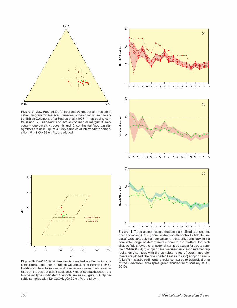
Fig ure 9. MgO-FeOt-Al2O3 (an hy drous weight per cent) dis crim i -na tion di a gram for Wallace For ma tion vol ca nic rocks, south-cen -tral Brit ish Co lum bia, af ter Pearce et al. (1977). 1, spread ing cen -tre is land; 2, is land-arc and ac tive con ti nen tal mar gin; 3, mid-ocean-ridge ba salt; 4, ocean is land; 5, con ti nen tal flood bas alts.Sym bols are as in Fig ure 3. Only sam ples of in ter me di ate com po -si tion, 51<SiO2<56 wt. %, are plot ted.

REFERENCES
Cox, K.G., Bell, J.D. and Pankhurst, R.J. (1979): The In ter pre ta -tion of Ig ne ous Rocks; George, Allen and Unwin, Lon don.
Dostal, J., Church, B.N. and Höy, T. (2001): Geo log i cal and geo -chem i cal ev i dence for vari able magmatism and tec ton ics inthe south ern Ca na dian Cor dil lera: Pa leo zoic to Ju ras sicsuites, Green wood, south ern Brit ish Co lum bia; Ca na dianJour nal of Earth Sci ences, Volume 38, pages 75–90.
Fyles, J.T. (1990): Ge ol ogy of the Green wood–Grand Forks area,Brit ish Co lum bia, NTS 82E/1, 2; BC Min is try of En ergy,Mines and Pe tro leum Re sources, Open File 1990-25,19 pages.
Höy, T. and Dunne, K.P.E. (1997): Early Ju ras sic Rossland Group,south ern Brit ish Co lum bia: part I, stra tig ra phy and tec ton -ics; BC Min is try of En ergy, Mines and Pe tro leum Re sources, Bul le tin 102, 124 pages.
Irvine, T.N. and Baragar, W.R.A. (1971): A guide to the chem i calclas si fi ca tion of the com mon vol ca nic rocks; Ca na dianJour nal of Earth Sci ences, Vol ume 8, pages 523–548.
Lit tle, H.W. (1957): Ket tle River (east half), Brit ish Co lum bia;Geo log i cal Sur vey of Can ada, Map 6-1957, scale 1:253 440.
Lit tle, H.W. (1961): Ket tle River (west half), Brit ish Co lum bia;Geo log i cal Sur vey of Can ada, Map 15-1961, scale1:253 440.
Massey, N.W.D. (2006): Bound ary Pro ject: re as sess ment of Pa -leo zoic rock units of the Green wood area (NTS 82E/02),south ern Brit ish Co lum bia; in Geo log i cal Field work 2005,BC Min is try of En ergy, Mines and Pe tro leum Re sources, Pa -per 2006-1 and Geoscience BC, Re port 2006-1, pages 99–107.
Massey, N.W.D. (2007): Bound ary Pro ject: Rock Creek area(82E/02W; 82E/03E); in Geo log i cal Field work 2006, BCMin is try of En ergy, Mines and Pe tro leum Re sources, Pa per2007-1 and Geoscience BC, Re port 2007-1, pages 117–128.
Massey, N.W.D. (2008): The Knob Hill Com plex—a Pa leo zoicsu pra-subduction zone ophiolite in south east ern Brit ish Co -lum bia?; Cordilleran Tec ton ics Work shop 2008, Pro gramand Ab stracts, page 35.
Massey, N.W.D. and Duffy, A. (2008a): Bound ary pro ject:McKinney Creek (82E/03) and Beaverdell (82E/06E,82E/07W, 82E/10W and 82E/11W) ar eas; in Geo log i calField work 2007, BC Min is try of En ergy, Mines and Pe tro -leum Re sources, Pa per 2008-1, pages 87–102.
Massey, N.W.D. and Duffy, A. (2008b): Ge ol ogy and min eral de -pos its of the area east of Beaverdell, Brit ish Co lum bia (partsof NTS 082E/6E; 082E/07W; 082E/10W; 082E/11E); BCMin is try of En ergy, Mines and Pe tro leum Re sources, OpenFile 2008-9, scale 1:25 000.
Massey, N.W.D., Mortensen, J.K., Gabites, J. and Ullrich, T.D.(2010): Bound ary pro ject: geo chron ol ogy and geo chem is -try of Ju ras sic and Eocene in tru sions; in Geo log i cal Field -work 2009, BC Min is try of En ergy, Mines and Pe tro leumRe sources, Pa per 2010-1, pages 43–58.
Mullen, E.D. (1983): MnO/TiO2/P2O5: a mi nor el e mentdiscriminant for ba saltic rocks of oce anic en vi ron ments andits im pli ca tion for petro gen esis; Earth and Plan e tary Sci -ence Let ters, Vol ume 62, pages 53–62.
Nakamura, N. (1974): De ter mi na tion of REE, Ba, Fe, Mg, Na andK in car bo na ceous and or di nary chondrites; Geochimica etCosmochimica Acta, Vol ume 38, pages 757–775.
Pearce, J.A. (1983): Role of the sub-con ti nen tal litho sphere inmagma gen e sis at ac tive con ti nen tal mar gins; in Con ti nen tal Bas alts and Man tle Xe no liths, Hawkesworth, C.J. andNorry, M.J., Ed i tors, Shiva, Nantwich, pages 230–249.
Pearce, J.A. and Cann, J.R. (1973): Tec tonic set ting of ba sic vol ca -nic rocks de ter mined us ing trace el e ment anal y ses; Earthand Plan e tary Sci ence Let ters, Vol ume 19, pages 290–300.
Geo log i cal Field work 2009, Pa per 2010-1 151
Fig ure 12. Rare earth el e ment abun dances nor mal ized tochondrite (af ter Nakamura, 1974): a) Crouse Creek mem ber vol ca -nic rocks; the pink shaded field shows the range for all sam ples ex -cept for the dacite sam ple 07NMA31-04; b) aphyric bas alts(dikes?) in clastic sed i men tary rocks; the pink shaded field as in a); c) aphyric bas alts (dikes?) in clastic sed i men tary rocks com paredto Ju ras sic diorite of the Beaverdell area, pale green shaded field(Massey et al., 2010).
Pearce, T.H., Gorman, B.E. and Birkett, T.C. (1977): The re la tion -ship be tween ma jor el e ment chem is try and tec tonic en vi ron -ment of ba sic and in ter me di ate vol ca nic rocks; Earth andPlan e tary Sci ence Let ters, Vol ume 36, pages 121–132.
Reinecke, L. (1915): Ore de pos its of the Beaverdell map-area;Geo log i cal Sur vey of Can ada, Mem oir 79, 172 pages.
Tempelman-Kluit, D.J. (1989a): Geo log i cal map with min eral oc -cur rences, fos sil lo cal i ties, ra dio met ric ages and grav ityfield for Penticton map area (NTS 82/E) south ern Brit ishCo lum bia; Geo log i cal Sur vey of Can ada, Open File 1969.
Tempelman-Kluit, D.J. (1989b): Ge ol ogy, Penticton, Brit ish Co -lum bia; Geo log i cal Sur vey of Can ada, Map 1736A, scale1:250 000.
Thomp son, R.N. (1982): Brit ish Ter tiary vol ca nic prov ince; Scot -tish Jour nal of Ge ol ogy, Vol ume 18, pages 49–107.
Wood, D.A. (1980): The ap pli ca tion of a Th-Hf-Ta di a gram toprob lems of tectonomagmatic clas si fi ca tion and to es tab -lish ing the na ture of crustal con tam i na tion of ba saltic lavasof the Brit ish Ter tiary vol ca nic prov ince; Earth and Plan e -tary Sci ence Let ters, Vol ume 50, pages 11–30.
152 Brit ish Co lum bia Geo log i cal Sur vey