Embed Size (px)
Citation preview

Fire Management Strategy Bouddi National Park & Cockle Bay Nature Reserve

FIRE MANAGEMENT STRATEGY
BOUDDI NATIONAL PARK AND COCKLE BAY NATURE RESERVE
NSW National Parks and Wildlife Service (NPWS) Central Coast Hunter Range Region
July 2008
ACKNOWLEDGEMENTS This Fire Management Strategy was prepared by the staff of the Central Coast Hunter Range Region of the NSW National Parks and Wildlife Service (NPWS). Cover Photograph: Looking north from Hawke Head Drive over Bouddi National Park (Jeff Betteridge). Published by the Department of Environment and Climate Change (NSW) July 2008. Copyright Department of Environment and Climate Change (NSW) Apart from any fair dealing for the purposes of private study, research, criticism or review, as permitted under the Copyright Act, no part may be reproduced by any process without written permission. Contact: NSW National Parks and Wildlife Service, Central Coast Hunter Range Region, PO Box 1477, Gosford, NSW 2250. ISBN 1 74137 858 3 DEC: 2006/120

TABLE OF CONTENTS 1 INTRODUCTION ...................................................................................................................................... 6
1.1 SCOPE, TERM AND PURPOSE .............................................................................................................. 6 1.2 RESERVE FIRE MANAGEMENT STRATEGY OBJECTIVES ......................................................................... 7 1.3 DESCRIPTION OF THE RESERVES......................................................................................................... 9
1.3.1 Location and Terrain.................................................................................................................................... 9 1.3.2 Natural and Cultural Heritage Values ........................................................................................................ 10 1.3.3 Recreational Use and Facilities ................................................................................................................. 12 1.3.4 Reserve Interface and Infrastructure ......................................................................................................... 12 1.3.5 The Fire Environment ................................................................................................................................ 12 1.3.6 Summary of Key Fire Issues ..................................................................................................................... 18
2 BUSHFIRE RISKS.................................................................................................................................. 19 2.1 INTRODUCTION ................................................................................................................................. 19 2.2 LIFE AND PROPERTY RISKS ............................................................................................................... 19
2.2.1 Utilities and infrastructure .......................................................................................................................... 20 2.2.2 Visitor Safety ............................................................................................................................................. 21
2.3 NATURAL HERITAGE RISKS ............................................................................................................... 21 2.3.1 Inappropriate fire regimes.......................................................................................................................... 21 2.3.2 Adverse fire management activities........................................................................................................... 22 2.3.3 Soil Erosion ............................................................................................................................................... 22 2.3.4 Pest species invasion ................................................................................................................................ 22
2.4 CULTURAL HERITAGE RISKS.............................................................................................................. 23 2.4.1 Aboriginal Heritage Values ........................................................................................................................ 23 2.4.2 Historic Heritage Values ............................................................................................................................ 23
3 BUSH FIRE RISK MANAGEMENT STRATEGIES ............................................................................... 24 3.1 INTRODUCTION ................................................................................................................................. 24 3.2 FIRE MANAGEMENT ZONES ............................................................................................................... 24 3.3 COOPERATIVE MANAGEMENT............................................................................................................. 26 3.4 BUSHFIRE PREVENTION .................................................................................................................... 26 3.5 BUSHFIRE SUPPRESSION .................................................................................................................. 27
3.5.1 Incident Preparedness............................................................................................................................... 27 3.5.2 Response .................................................................................................................................................. 28 3.5.3 Recovery ................................................................................................................................................... 28
3.6 FUEL MANAGEMENT.......................................................................................................................... 29 3.6.1 Prescribed Burning.................................................................................................................................... 29 3.6.2 Fire Breaks ................................................................................................................................................ 30
3.7 FIRE MANAGEMENT ACCESS ............................................................................................................. 30 3.7.1 Classification of Trails................................................................................................................................ 30 3.7.2 Trail Construction & Maintenance.............................................................................................................. 31 3.7.3 Walking Tracks.......................................................................................................................................... 31 3.7.4 Hand tool lines........................................................................................................................................... 32
3.8 OTHER FIRE CONTROL ADVANTAGES................................................................................................. 32 3.9 ENVIRONMENTAL ASSESSMENT ......................................................................................................... 32
3.9.1 Smoke Management ................................................................................................................................. 33 3.10 COMMUNITY EDUCATION AND COOPERATION ..................................................................................... 33 3.11 RESEARCH AND MONITORING ............................................................................................................ 34
4 REFERENCES ....................................................................................................................................... 35 STRATEGIC FIRE ADVANTAGE ZONES ............................................................................................................. 49 LAND MANAGEMENT ZONES ........................................................................................................................... 54

LIST OF FIGURES FIGURE 1 FIRE MANAGEMENT PLANNING FRAMEWORK ........................................................ 8 FIGURE 2 ANNUAL AREA BURNT BY WILDFIRES ................................................................... 14 FIGURE 3 CAUSES OF WILDFIRE IGNITIONS......................................................................... 14 FIGURE 4 MONTH OF IGNITION FOR WILDFIRES................................................................... 15 FIGURE 5 AREA TREATED BY PRESCRIBED BURNS. ............................................................. 16 FIGURE 6 CALCULATIONS OF BUSHFIRE BEHAVIOUR POTENTIAL.......................................... 62 LIST OF MAPS MAP 1 LOCATION OF BOUDDI NATIONAL PARK AND COCKLE BAY NATURE RESERVE............. 9 MAP 2.1 BUSHFIRE RISKS – PROPERTY, VISITOR SITES, HISTORIC HERITAGE VALUES ....... 68 MAP 2.2 BUSHFIRE RISKS – ENDANGERED ECOLOGICAL COMMUNITIES.............................. 68 MAP 2.3 BUSHFIRE RISKS – THREATENED FLORA & FAUNA................................................ 68 MAP 2.4 BUSHFIRE RISKS – EROSION HAZARDS, ACID SULPHATE SOILS............................. 68 MAP 2.5 BUSHFIRE RISKS – FIRE REGIME ANALYSIS.......................................................... 68 MAP 3.1 FIRE MANAGEMENT STRATEGIES – ZONATION...................................................... 68 MAP 3.2 FIRE MANAGEMENT STRATEGIES – ACCESS TRAILS ............................................. 68 MAP 3.3 FIRE MANAGEMENT STRATEGIES – BUSHFIRE BEHAVIOUR POTENTIAL.................. 68 LIST OF TABLES TABLE 1 VEGETATION COMMUNITIES OF REGIONAL SIGNIFICANCE..................................... 110 TABLE 2 SPECIES OF HIGH CONSERVATION SIGNIFICANCE.................................................. 11 TABLE 3 PROPERTY AND FACILITIES AT RISK FROM WILDFIRE.............................................. 20 TABLE 4 SUMMARY OF FIRE MANAGEMENT ZONES............................................................. 25 TABLE 5 CLASSIFICATION OF FIRE TRAILS.......................................................................... 31 TABLE 6 VEHICLE CARRYING CAPACITY............................................................................. 31 TABLE 7 PRIORITIES FOR FIRE MANAGEMENT RESEARCH.................................................... 34 LIST OF APPENDICIES APPENDIX 1: FIRE REGIME GUIDELINES FOR VEGETATION COMMUNITIES ............................. 39 APPENDIX 2: FIRE REGIME GUIDELINES FOR THREATENED FLORA SPECIES......................... 40 APPENDIX 3: FIRE MANAGEMENT GUIDELINES FOR THREATENED FAUNA SPECIES............... 41 APPENDIX 4: GUIDELINES FOR ABORIGINAL HERITAGE MANAGEMENT ................................. 45 APPENDIX 5: GUIDELINES FOR HISTORIC HERITAGE MANAGEMENT ..................................... 47 APPENDIX 6:FIRE MANAGEMENT ZONES .......................................................................... 48 APPENDIX 7: STANDARD OPERATIONAL GUIDELINES ........................................................... 56 APPENDIX 8: FIRE TRAIL & ROAD REGISTER........................................................................ 59 APPENDIX 9: BUSHFIRE BEHAVIOUR POTENTIAL ................................................................. 61 APPENDIX 10: GLOSSARY ................................................................................................. 63

6
1 INTRODUCTION 1.1 Scope, Term and Purpose This document describes the strategies the National Parks and Wildlife Service (NPWS) plans to implement to meet its fire management responsibilities under the Rural Fires Act 1997, National Parks and Wildlife Act 1974, Threatened Species Conservation Act 1995, and other relevant legislation in Bouddi National Park and Cockle Bay Nature Reserve (hereafter referred to as the Reserves). The strategy has been prepared in accordance with the policies and procedures detailed in the NPWS Fire Management Manual. It complies with the management objectives detailed in the Bouddi National Park Draft Plan of Management (NPWS, 1999b) and the Cockle Bay, Rileys Island, Pelican Island, and Saratoga Island Nature Reserves Draft Plan of Management (DECC, 2007). In addition, the strategy has been prepared in consultation with the Gosford Bush Fire Management Committee, the NSW Rural Fire Service, park neighbours and other stakeholders. The relationship between this strategy and other planning documents is shown in Figure 1. This strategy is supported by: • Gosford District Bush Fire Management Committee’s Plan of Operations and Bushfire Risk
Management Plan; • Fire Management Work Schedules that are prepared annually and list the fire management
strategies to be implemented each year; • Bushfire Suppression Guidelines, a map based Fire Management Strategy for the reserves,
which identify natural and cultural values, and infrastructure to be protected from bushfire; • Central Coast Hunter Range Region Incident Procedures which are prepared annually and detail
general bushfire preparedness and response procedures; and • Hardcopy maps and a Geographic Information System (GIS) database maintained at the NPWS
Central Coast Hunter Range Regional Office, Gosford. This fire management strategy will be reviewed five years from the date of approval or as required in consultation with Gosford Bush Fire Management Committee. It is likely that wildfires will occur during this period which will affect proposed fire regimes. If fires occur, the prescribed burning program will be modified so that a mosaic pattern of fire is maintained across the environment.
Bouddi National Park and Cockle Bay Nature Reserve Reserve Fire Management Strategy 2008-2013
7
1.2 Reserve Fire Management Strategy Objectives In accordance with the statutory obligations and policies of NPWS as defined in the NPWS Fire Management Manual (NPWS, 2006), the fire management objectives for Bouddi National Park and Cockle Bay Reserve are to: Objective 1: protect life, property & community assets from the adverse impact of fire; Objective 2: develop & implement cooperative & coordinated fire management
arrangements with other fire authorities, reserve neighbours & the community;
Objective 3: manage fire regimes within reserves to maintain & enhance biodiversity; Objective 4: protect Aboriginal sites known to exist within NSW & historic places &
culturally significant features known to exist within reserves from damage by fire; &
Objective 5: assist other fire agencies, land management authorities & landholders in developing fire management practices to conserve biodiversity & cultural heritage across the landscape.

Bouddi National Park and Cockle Bay Nature Reserve Reserve Fire Management Strategy 2008-2013
8
Figure 1 Fire Management Planning Framework
NPWS Fire Management Manual • Applies to all NPWS reserves • Identifies NPWS fire management policies, procedures and guidelines • May be supplemented by circulars
Threat Abatement Plan, Threatened Species Recovery Plan or Priority Action Statement
• Specific to a threatening process or a threatened species, population or community
• Identifies policy, procedures and actions for management
Reserve Plan of Management • Specific to a particular NPWS reserve • Provides objectives, policies and actions to be
implemented within the reserve Sydney Basin Fire Management Strategy • Applies to the NPWS Central Branch area of
the Sydney Basin bio-region • Identifies Central Branch fire management
priorities
Reserve Fire Management Strategy (this document)
• Specific to the reserves identified under this strategy • Profiles bushfire risks within and adjacent to reserves • Identifies risk management strategies to be implemented within a reserve over a 5 year time frame • Provides additional guidelines detailing specific management strategies within the reserve
Bush Fire Management Committee Risk Management Plan • Identifies levels of bushfire risk to assets • Identifies risk management strategies to be
implemented by member agencies
Bush Fire Management Committee Operations Coordination Plan • Identifies cooperative arrangements for fire
response and notification • Pre-planned communications and mapping data
NPWS Annual Fire Works Programs • Specific to NPWS reserves • Identifies the actions to be undertaken in the
financial year • Developed in coordination with BFMC using
priority risk assessment framework
NPWS Regional Incident Procedures (RIPs) • Specific to NPWS regions • Identify the procedures for fire preparedness and
response • Contains a contact database of staff, other
agencies and organisations • Supported by annual bushfire suppression maps
Operational Plans • Specific to individual risk management strategy
within a reserve Incident Action Planning • Specific to an individual fire incident.

Bouddi National Park and Cockle Bay Nature Reserve Reserve Fire Management Strategy 2008-2013
9
1.3 Description of the Reserves 1.3.1 Location and Terrain This fire management strategy applies to Bouddi National Park (1532 ha) and Cockle Bay Nature Reserve (44 ha). In addition to the Reserves, the strategy also considers fuels, assets and fire control advantages that are outside but contiguous with, or adjacent to, those in the Reserves including 24.5 ha of land identified as proposed additions to Cockle Bay Nature Reserve. The Reserves are located within Gosford Local Government Area on the Central Coast of New South Wales approximately 20km south-east of Gosford (Map 1). The Reserves protect a large area of the Bouddi Peninsula extending from Box Head to MacMasters Beach through to Kincumber, Cockle Bay and Half Tide Rocks. Map 1 Location of Bouddi National Park and Cockle Bay Nature Reserve

Bouddi National Park and Cockle Bay Nature Reserve Reserve Fire Management Strategy 2008-2013
10
Elevation within the reserves extends from sea level to 166m at Mt Bouddi. The reserves contain a range of coastal landform features, from the sandstone plateau of Bouddi Ridge to protected foreshores of Brisbane Water. Hawkesbury sandstone dominates the higher levels forming plateau outliers and prominent spurs running in a NW direction at Box Head-Wagstaffe, Daleys Point, NW Ridge and MacMasters Ridge. The Narrabeen Group (Terrigal Formation), which underlies the Hawkesbury Sandstone occurs extensively throughout the reserve and is evident on the steep hills, coastal slopes and headlands. Steep, semi-circular catchments, backed by sandstone escarpments occur at Tallow Beach, Putty Beach and Maitland Bay. Bouddi National Park protects a number of small catchments each with intermittent watercourses and two semi-permanent coastal lagoons. Catchments, watercourses and coastal lagoons in a largely natural condition and unaffected by surrounding development are uncommon along the Sydney/ Central Coast/ Newcastle coastline. Cockle Bay Nature Reserve is part of a floodplain dominated by Quaternary Alluvium with some minor outcrops from the Terrigal Formation. 1.3.2 Natural and Cultural Heritage Values
Flora A number of vegetation surveys have been carried out within the study area, including those by Siddiqi et al. (1971-76), Strom et al. (1986), McRae (1990), Payne (1997) and Bell (2004). Over 700 plant species amongst 20 vegetation communities have been recorded within the reserves (Kelly 2001, Bell 2004). These include a variety of structural forms ranging from grassland, heath, woodland, shrubland, and forest communities. The most common vegetation communities are highly flammable dry sclerophyll forest, woodland, heath and shrublands which occupy over 70% of the Reserves. A list of vegetation communities found within the Reserves along with their fire regime guidelines is provided in Appendix 1. Several of the vegetation communities occurring within the area are of regional significance (Map 2.2), they are listed in Table 1.
Table 1 Vegetation communities of regional significance in Bouddi National Park and Cockle Bay Nature Reserve.
Community Location Swamp Sclerophyll Forest on Coastal Floodplains Endangered Ecological Community dominated by Eucalyptus robusta, Melaleuca quinquenervia.
Bensville, Rileys Bay and within Cockle Bay Nature Reserve
Swamp Oak Floodplain Forest Endangered Ecological Communities. Cockle Bay Nature Reserve Coastal Saltmarsh Endangered Ecological Community. Cockle Bay Nature Reserve Themeda grassland on sea-cliffs and coastal headlands Endangered Ecological Communities.
Bouddi National Park
Wagstaffe Spotted Gum-Ironbark Forest occurs on soils derived from the Narrabeen series. This community has strong similarities to the Pittwater Spotted Gum Forest Endangered Ecological Community.
Hardys Bay and Wagstaffe
Coastal Sand Wallum Heath dominated by Banksia aemula occurs on Pleistocene sand dunes. This community has strong similarities to Eastern Suburbs Banksia Scrub Endangered Ecological Community.
Bombi and Mourawaring Moors within Bouddi National Park
Killcare Hawkesbury Woodland on Laterite- Hawkesbury Sandstone Geology with soils of the Somersby soil landscape unit. The community shows strong similarities with Duffys Forest Endangered Ecological Community
Killcare Heights
Coastal Warm Temperate Forest occurs within sheltered gullies on Narrabeen Sandstone. The community contains examples of Lowland
Bouddi Grand Deep

Bouddi National Park and Cockle Bay Nature Reserve Reserve Fire Management Strategy 2008-2013
11
Rainforest in the Sydney Basin Endangered Ecological Community. The Reserves contain a number of local endemic flora species, which are threatened primarily by development, habitat loss, weed invasion and inappropriate fire regimes. Two species listed as vulnerable under the Threatened Species Conservation Act 1995 have been recorded within Bouddi National Park: Syzygium paniculatum and Melaleuca biconvexa (Map2.3). A list of threatened flora species found within the Reserves along with their fire regime guidelines is provided in Appendix 2. The Reserves also protect a number of species of high conservation significance which are listed in Table 2. Table 2 Species of high conservation significance in Bouddi National Park and Cockle Bay Nature Reserve. • Syzygium paniculatum (TSC - Vulnerable) • Melaleuca biconvexa (TSC - Vulnerable) • Acacia quadrilateralis • Howittia trilocularis • Alpinia arundelliana • Lepidosperma quadrangulatum • Banksia aemula • Olearia nernstii • Banksia robur • Parachidendron pruinosum • Blechnum ambiguum • Parsonsia velutuna • Brachycome sp. • Ripogonum fawceltianum • Cryptocarya rigida • Rulingia hermaniifolia • Eucalyptus capitellata • Tetrastigma nitens • Eucalyptus robusta • Tylophora barbata • Eucalyptus scias ssp. scias
Fauna The Reserves protect important habitat for native animals on the Central Coast. The diversity of habitats in the Reserves support populations of about 254 native vertebrate animal species (including 12 amphibian, 166 bird, 36 reptile and 40 mammal species including marine mammals). Thirty fauna species listed under the Threatened Species Conservation Act, 1995, occur within the Reserves, of which 21 are considered to be at risk from fire and fire management activities (Appendix 3). The Regent Honeyeater (Xanthomyza phrygia), Bush Stone-curlew (Burhinus grallarius), and Swift Parrot (Lathamus discolor) are listed as Endangered (Schedule 1) and are the highest priority species within the area (Map2.3).
Cultural Heritage Over 70 Aboriginal sites containing over 200 features have been recorded within the Reserves. Aboriginal occupation is evident in the form of grinding grooves, rock engravings, shelters containing art, middens, deposits, burials and scarred trees. Figures commonly depicted in engravings are fish, shields and wallabies. No Aboriginal sites are recorded in Cockle Bay Nature Reserve, although middens and open artefact scatter sites are likely to occur (Lambert, D pers. comm.). Appendix 4 lists the guidelines for Aboriginal heritage management. Twenty seven historic sites and features occur in Bouddi National Park (Appendix 5). These include the Maitland Bay Store, Strom’s House, Murray’s House ruins, Bombi military emplacements, Dingledei Memorial Shelter, memorial plaques, the Maitland Shipwreck, foundations of fishing huts and associated landscaping at Lobster Beach and infrastructure associated with mining. No sites are recorded in Cockle Bay Nature Reserve.
Bouddi National Park and Cockle Bay Nature Reserve Reserve Fire Management Strategy 2008-2013
12
1.3.3 Recreational Use and Facilities Bouddi National Park provides an important recreational resource, receiving 150,000 – 200,000 visitors each year. During the bushfire danger period there may be as many as 500 visitors within the reserve, particularly near Putty Beach. Bouddi National Park offers a variety of recreational opportunities ranging from camping, picnicking, bushwalking, mountain bike riding, fishing and other beach activities. Recreational opportunities in Cockle Bay Nature Reserve are limited and public visitation is estimated at less than 1000 visitors annually. Facilities within the Reserves include NPWS buildings, camping areas, picnic areas, amenities, lookouts and work sheds. These are listed in Table 3 (p.20) and illustrated in Map 2.1. 1.3.4 Reserve Interface and Infrastructure The Reserves are adjacent to medium-density residential development and small semi-rural holdings in the MacMasters Beach, Bensville, Killcare Heights, Hardys Bay, Pretty Beach, Wagstaffe, Daleys Point and Empire Bay areas. The reserves have approximately 30km of residential interface, with approximately 850 properties immediately adjoining the Reserves. Isolated houses or sheds occur on the perimeter of the Reserves at Empire Bay (Oyster Shed), Lobster Beach, The Scenic Road, Grahame Drive, MacMasters Beach and Maitland Bay Drive. A large proportion of existing assets and property do not conform to Australian Standards for building construction nor have established and maintained Asset Protection Zones on private property as described in Planning for Bushfire Protection (RFS, 2006a). 1.3.5 The Fire Environment
Fire History Fire history records for the NPWS Central Coast Hunter Range Region date back to 1968. Records have been compiled from NPWS and NSW Rural Fire Service maps, incident reports and anecdotal evidence from service staff, local fire brigade members and reserve neighbours. With age, the accuracy and relevance of the fire history records decreases, therefore, conclusions made from the database have been drawn with caution. This data has been compiled onto the regional Geographic Information System (GIS). Knowledge of fire regimes prior to European settlement is limited; however it is likely that large-scale uncontained wildfires would have occurred in the area. Historic patterns of fire in the landscape have changed as a result of fragmentation caused by development and improvements in contemporary fire suppression methods. About 200 fires (wildfires and prescribed burns) have been recorded in the reserves in the 38 year period between 1968 and 2007. Figure 2 shows the annual area burnt by wildfires in the Reserves. The incidence of wildfires varies greatly from season to season. Three large wildfires in 1968, 1974 and 1976 have together burnt most of the Bouddi National Park. The 1968-69 fire season was the most significant with approximately 70% of the park being burnt in one fire event. Since 1980, the reserve has experienced a lower number of fires and on average a lower area burnt per annum. This is a result of improved fire management practices (such as improved state of

Bouddi National Park and Cockle Bay Nature Reserve Reserve Fire Management Strategy 2008-2013
13
readiness, reduced response times, improved access, high suppression capability and a committed prescribed burning program) within the Reserves. Traditionally, large fires have moved from the Bensville and South Kincumber areas under a north-westerly influence along the main ridgelines (NW Ridge, Daleys Point Ridge and MacMasters Ridge) into the Killcare Heights and MacMasters Beach area. Cockle Bay Nature Reserve was gazetted in March 1992. Limited information is available on the fire history of the reserve before this time. Approximately 20 hectares was burnt by a wildfire in 1991 with smaller fires occurring in 1998 and 2002 (<2 hectares). The majority of the Reserves, with the exception of Bouddi Grand Deep and estuarine communities within Cockle Bay Nature Reserve have experienced fire.

Bouddi National Park and Cockle Bay Nature Reserve Reserve Fire Management Strategy 2008-2013
14
Figure 2 Annual area burnt by wildfires in the Reserves between 1968-2006
Bushfire Ignitions The main causes of wildfire ignitions in the Reserves are from arson or suspected arson (Figure 3). The cause of 47% of wildfires occurring in the reserves remains unknown. This is due to limited information, particularly for older records and limited post fire investigation and reporting.
Figure 3 Causes of wildfire ignitions in Bouddi National Park and Cockle Bay Nature Reserve between 1968- 2006.
0100200300400500600700800900
1968
-69
1970
-71
1972
-73
1974
-75
1976
-77
1978
-79
1980
-81
1982
-83
1984
-85
1986
-87
1988
-89
1990
-91
1992
-93
1994
-95
1996
-97
1998
-99
2000
-01
2002
-03
2004
-05
Year
Hec
tare
s bu
rnt
Arson42%
Camp Cooking4%
Unknown47%
Motor Vehicle1%
Arson Suspected6%

Bouddi National Park and Cockle Bay Nature Reserve Reserve Fire Management Strategy 2008-2013
15
An analysis of the distribution of known ignition points indicates a trend for ignitions along roads, tracks, trails, camping areas and other key visitor sites. Figure 4 shows the monthly occurrence of wildfires within the Reserves. Fires may occur at any time during the year if conditions permit. The majority of fires generally occur from September through to February, with a peak in December and January. There is a marked decline in the number of fires after January likely associated with high moisture, easterly weather patterns and less windy conditions.
Figure 4 Month of ignition for wildfires within Bouddi National Park and Cockle Bay Nature Reserve between 1968-2006 (records where no information is available on the date of ignition have been omitted from the analysis). Prescribed burning Since 1973, 90 prescribed burns have been completed within Bouddi National Park. No prescribed burns have been undertaken in Cockle Bay Nature Reserve. The area burnt by prescribed burns each year within the reserves is shown in Figure 5. The majority of prescribed burns are small in area but are strategically located to reduce fuel loads adjacent to high-risk assets and in areas of high arson probability or to strengthen existing fire control advantages. A small number of prescribed burns have been implemented to maintain ecological processes within vegetation communities.
0
2
4
6
8
10
12
14
16
Janu
ary
Febr
uary
Mar
ch
April
May
June
July
Augu
st
Sept
embe
r
Oct
ober
Nov
embe
r
Dec
embe
r
Month of the year
Num
ber o
f fire
s

Bouddi National Park and Cockle Bay Nature Reserve Reserve Fire Management Strategy 2008-2013
16
Figure 5 Area treated by prescribed burns in Bouddi National Park between 1973-2006.
Fire frequency Fire frequency is defined simply as the number of fires over a given period of time. Both Bouddi National Park and Cockle Bay Nature Reserve have a history of infrequent wildfires. Large areas of the Reserves have only been burnt once since 1968 during wildfire events. Areas along the Scenic Road, Killcare Heights and Beachview Esplanade, MacMasters Beach have been burnt up to eight times since 1968; largely as a result of active prescribed burning programs.
Fire Weather The climate of the Bouddi Peninsula is classified as temperate and is influenced by two major circulation patterns (BoM, 2001). In summer, synoptic high pressure systems move south causing prevailing winds with an easterly influence. Low pressure troughs between the highs bring first dry, hot north-westerly’s and then a wind shift to cooler southerlies. Rain may occur from troughs or orographic influences. Convective rainfall on hot afternoons is common (Bridgman and Oliver, 1995). Afternoon north-easterly and south-easterly have a moderating effect on temperatures. In winter, the sub-tropic ridge moves north, resulting in the dominance of a westerly regime. Cold fronts alternate with synoptic high pressure systems, bringing relatively cold airstreams from the southern oceans and rainfall. The prevailing winds are north-westerly. The average maximum temperature ranges from 9 - 27ºC during December to March, and 4-17ºC from June to August, however days in excess of 30ºC frequently occur during summer. The average annual rainfall for the area is approximately 1400mm with February and March being on average the wettest months.
0
20
40
60
80
100
120
140
1972
-73
1974
-75
1976
-77
1978
-79
1980
-81
1982
-83
1984
-85
1986
-87
1988
-89
1990
-91
1992
-93
1994
-95
1996
-97
1998
-99
2000
-01
2002
-03
2004
-05
Year
Hec
tare
s tr
eate
d

Bouddi National Park and Cockle Bay Nature Reserve Reserve Fire Management Strategy 2008-2013
17
Conditions associated with bush fires Weather conditions associated with serious bushfire seasons and events include: • High temperature air masses brought from the interior of the continent in high pressure systems; • Several days of strong NW winds prior to the passage of cold fronts; • Low relative humidity; • Negative SOI; • KBDI greater than 80; • FDI greater than 24; and • Soil dryness Index (SDI) greater than 80
Conditions suitable for prescribed burns Prescribed burning generally occurs outside of the bushfire danger period between 1st April and 30th September. To ensure that burns will be contained within predetermined boundaries, specific weather and climatic parameters must be met. Preferred conditions for prescribed burns include: • Temperature: suitable temperatures 17-270C; • Wind speed: less than 18km / h on the fire ground; • Wind direction: low probability of strong, dry north-westerly winds; • Relative humidity: optimum 30-60%, which affects fuel moisture; • Dew point: a high level of moisture recovery in fine fuels at night; • Days since rain: minimum 3 - maximum 35; • Fire Danger Index: Low to Moderate; • Drought Factor: 4-8; and • Synoptic weather systems: stable, slow moving high pressure system, followed by rain bearing
trough; bringing light north to north-westerly winds. Within the Reserves, there is a small window of opportunity (15-30 days per annum) where the above mentioned climatic conditions are suitable for prescribed burning. These days usually occur between April to June and August to October. The main limiting factor for successful burning into winter is the high probability of rain in late autumn and early winter. Rainfall in the study area is not strongly seasonal and conditions for prescribed burning in the cooler months are variable from year to year. The prevailing temperatures, humidity and shorter daylight hours during this period may prevent drying of surface fuels especially on southerly aspects, which have greater moisture retention due to shadows from topography and canopy vegetation.
Bouddi National Park and Cockle Bay Nature Reserve Reserve Fire Management Strategy 2008-2013
18
1.3.6 Summary of Key Fire Issues • The majority of the Reserves contain vegetation communities that can accumulate high fuel
loads and are prone to high intensity fires under a wide range of conditions. • Arson and suspected arson are responsible for a large number of bushfires within the reserves. • The reserves have an extensive residential-bushland interface, with a moderate number of
neighbours. • There are a large number of community assets within and adjacent to the reserves and
bushfires have the potential to threaten or damage these assets. • A large proportion of existing assets and property do not conform to Australian Standards for
building construction and have not established or maintained appropriate Asset Protection Zones on private property.
• The reserves protect natural and cultural heritage values that are vulnerable to inappropriate fire regimes and fire management activities.

Bouddi National Park and Cockle Bay Nature Reserve Reserve Fire Management Strategy 2008-2013
19
2 BUSHFIRE RISKS 2.1 Introduction Bushfire risk is defined as the chance of a fire or fire management activities impacting on significant values within the Reserves. For the purpose of this strategy, bushfire risks have been divided into three major groups: • life and property risks; • natural heritage risks; and • cultural heritage risks. In accordance with the NPWS Risk Management System, determining the level of risk requires an understanding of the likelihood of bushfire event occurring and the magnitude of its consequences (i.e. the extent of damage or impact on significant values). The risk assessment process involves the identification of all assets and values within and adjacent to the Reserves that are considered to be at risk from bushfires and the factors that contribute to their level of risk. In conjunction with Gosford BFMC, the level of risk that each asset and value is exposed to is determined. A major tool that supports the risk analysis process is a bushfire behaviour potential model that incorporates terrain (slope, aspect and altitude) and fuel (vegetation, fire history). Appendix 10 provides a description of how the model has been developed to classify the Reserves into one of four bushfire behaviour classes. The results of the risk analysis enable a range of risk management strategies and controls described in Section 3 to be applied. 2.2 Life and Property Risks Bushfire risk is a complex interaction between a number of variables, including: • ignition sources and patterns in the landscape; • the ability of property owners, residents and visitors to take appropriate action in the event of a
fire; • the adherence of properties to the building design and construction standards detailed in AS
3959; • the establishment and maintenance of adequate asset protection zones as described by
Planning for Bushfire Protection (RFS 2006a) within private lands; • the relative degree of isolation of communities and properties; • access for fire fighters to protect property; • the adequate deployment and response times of fire fighting resources, both ground and air, to
suppress fire and protect property; and • the fire behaviour potential of the landscape based on the interaction of topography, vegetation
type, fire history and fuel accumulation rates.

Bouddi National Park and Cockle Bay Nature Reserve Reserve Fire Management Strategy 2008-2013
20
There are 25 locations within and around the reserves where property and facilities are at risk from bushfires (Map 2.1) including isolated facilities and residential communities at MacMasters Beach, Bensville, Killcare Heights, Hardys Bay, Pretty Beach, Wagstaffe, Daleys Point and Empire Bay (Table 3). Table 3 Property and facilities at risk from wildfire within and adjacent to the Reserves Map ID
Location Tenure Map ID Location Tenure
T1 Putty Beach Day Use Area
NPWS T14
Bouddi Shed NPWS
T2 Mt Bouddi (Dingeldei) Day Use Area
NPWS T15
Boobialla House NPWS
T3 Lobster Beach Day Use Area
NPWS
T16
Bouddi Coastal Walk (main section of timber boardwalk)
NPWS
T4 Little Beach Camping Area
NPWS T17
MacMasters Beach Community Private
T5 Putty Beach Camping Area
NPWS T18
Bensville Community Private
T6 Tallow Beach Camping Area
NPWS T19
Killcare Heights Community Private
T7 Maitland Bay Centre NPWS
T20 Hardys Bay Community Private
T8 Allen Strom Lookout NPWS
T21 Pretty Beach Community Private
T9 Killcare Heights (Marie Byles) Lookout
GCC T22
Wagstaffe Community Private
T10 Flannel Flower Track Lookout
NPWS T23
Daleys Point Community Private
T11 Gerrin Point Lookout NPWS
T24 Empire Bay Community Private
T12 Buggeries Lookout NPWS
T25Empire Bay Oyster Shed Private
T13 Strom’s House & Centre NPWS
2.2.1 Utilities and infrastructure Within and adjacent to the reserves there are a variety of public and private utilities that are considered at risk from bushfires, including: • Energy Australia powerlines and substations; • Gosford City Council Water infrastructure; • Telecommunications infrastructure; and • DECC managed transmission lines, water pipelines and sewage pumping stations.
Bouddi National Park and Cockle Bay Nature Reserve Reserve Fire Management Strategy 2008-2013
21
2.2.2 Visitor Safety High visitation areas considered at risk include: • Little Beach Camping Area • Mt Bouddi Picnic Area • Maitland Bay Precinct including Marie Byles Lookout • Putty Beach Precinct • Bouddi Coastal Walk • Tallow Beach Camping Area • Lobster Beach Precinct There is a history of anti-social behaviour at Putty Beach, Little Beach and Tallow Beach camping areas and Mount Bouddi picnic area resulting in an increased incidence of illegal fires. 2.3 Natural Heritage Risks Natural heritage values at risk (such as endangered ecological communities, threatened flora and fauna, sensitive catchments and landscapes susceptible to erosion) are shown on Maps 2.2, 2.3 & 2.4. Natural heritage values may be placed at risk as a result of inappropriate fire regimes, adverse fire management activities, and post fire erosion and pest species invasion. 2.3.1 Inappropriate fire regimes Fire regimes are defined by the combination of fire frequency, intensity, season of occurrence, fire type and extent (Whelan, 1995). High fire frequency has been identified as a key threatening process, as it disrupts key life cycle processes in plants and animals. High fire frequency fire may cause the local extinction of species and populations by directly killing individuals, altering critical habitat requirements of species, changing the availability of resources, and enhancing the opportunities for predation and the spread of weeds. Alternatively, the exclusion of fire for an extended period of time may lead to the senescence of plants and their seed banks and the transition of other communities. An analysis of fire regimes within the Reserves shows a representative range of successional stages (age classes) exist within major vegetation communities. There are small areas within the reserves that have been burnt more frequently than the minimal interval and are exceeding their lower thresholds. There are also some areas that are exceeding their upper thresholds. Many of these areas are of major significance as they represent long un-burnt vegetation which is very rare (Map 2.5).

Bouddi National Park and Cockle Bay Nature Reserve Reserve Fire Management Strategy 2008-2013
22
Large wildfire events are a major risk to natural heritage values within the Reserves. This is because the Reserves are fragmented and isolated from other conservation reserves which reduces opportunities for species recruitment and recolonisation after major fire events. It is important that a single fire event does not completely burn a significant proportion (i.e. >50%) of a particular community type or the reserve. Unburnt areas within the Reserves provide a refuge for fauna species that may have suffered habitat loss during and soon after fire. These areas then become extremely important for the recolonisation and protection of species. 2.3.2 Adverse fire management activities Fire management activities associated with fire suppression operations, prescribed burning programs or fire trail maintenance may have an adverse impact on natural heritage features. Activities include the use of fire fighting equipment and heavy plant in the construction of fire breaks and trails and the use of salt water for fire suppression. 2.3.3 Soil Erosion Many of the soil landscapes within the reserves are prone to erosion. High intensity fires, track and trail construction, maintenance and other fire management works may contribute to greater levels of soil erosion and potential siltation. Specific impacts from soil erosion and run off may include alteration of landforms, the smothering of vegetation, increased sedimentation of drainage lines and water bodies, alteration of aquatic habitat and the invasion of weeds. Extreme erosion events following high intensity wildfires are of particular concern. These produce massive sediment loads and reduce the regenerative capacity of ecosystems through the removal of seed banks and nutrients. 2.3.4 Pest species invasion The establishment of vertebrate pest and weed species represents one of the major threats to the natural and cultural heritage values of the Reserves. Disturbance by fire may cause an increase in the invasion by weeds and predation and competition by vertebrate pests. Management of pest species within the Reserves is undertaken in accordance with the Central Coast Hunter Range Region Pest Management Strategy, 2007-2011 (NPWS, 2007).

Bouddi National Park and Cockle Bay Nature Reserve Reserve Fire Management Strategy 2008-2013
23
2.4 Cultural Heritage Risks 2.4.1 Aboriginal Heritage Values Aboriginal sites are susceptible to damage and may be destroyed by fire and fire suppression operations (English, 2000). Risks may include: • High-intensity wildfires which impact on scar trees; • Soil erosion may be accelerated by fire by removing vegetation, logs and trees which help hold
soil in situ, exposing Aboriginal sites resulting in artefact movement and making them susceptible to damage;
• Art sites may be damaged from smoke staining, which may lead to chemical weathering, particularly if protective vegetation is removed. Intense heat may also cause exfoliation of the rock surface; and
• Vehicle traffic, including fire appliances, bulldozers, slashers or tritters, may damage sites. Aboriginal sites occur throughout Bouddi National Park and adjacent to Cockle Bay Nature Reserve. Due to cultural sensitivity, sites locations have not been shown in this strategy. The location of sites is available through AHIMS at all NPWS offices. Appendix 4 lists the guidelines for Aboriginal site management. 2.4.2 Historic Heritage Values Fire may damage Historic heritage values within the Reserves through a number of factors: • Bushfires may directly remove or destroy combustible material such as timber structures. • High-intensity fires may permit soil erosion, which may lead to displacement of foundations,
artefact movement and damage to archaeological deposits. • Vehicles or bulldozers may physically damage features. • Fire may damage or destroy vegetation with historical significance. • High-intensity fire may also cause the spalling of rock artefacts. Historic Heritage Site locations are shown on Map 2.1. Appendix 5 lists the guidelines for historic site management.

Bouddi National Park and Cockle Bay Nature Reserve Reserve Fire Management Strategy 2008-2013
24
3 BUSH FIRE RISK MANAGEMENT STRATEGIES 3.1 Introduction This Section describes the strategies that will be implemented to reduce bushfire risk to assets and values within and adjacent to the Reserves (as identified in Section 2). Given the large number of assets within and around the reserves it is not possible to implement strategies and controls for all assets and values every year in all locations. A Fire Management Works Schedule will be prepared annually, listing priority fire management strategies for the Reserves. An integrated approach to fire management has been adopted, using a range of strategies including public education, land-use planning, fuel reduction, fire trail maintenance, specialised suppression activities, and cooperative arrangements with other authorities and neighbours. The strategies are implemented in consultation with Gosford BFMC, the Rural Fire Service (RFS), NSW Fire Brigades, park neighbours and other stakeholders. The cooperation of the community is critical to the success of many strategies. In particular, the NPWS must work with BFMCs to encourage neighbours to accept responsibility for the management of fuels on their properties, to prepare and maintain their properties in accordance with AS 3959, and to develop personal action plans that can be activated in the event of a bushfire. 3.2 Fire Management Zones The Reserves and adjacent bushland have been divided into Fire Management Zones according to a zoning system described by the NPWS. Fire Management Zones developed for the reserves were created in consultation with the Gosford Bush Fire Management Committee and will be incorporated into the revised Gosford Bush Fire Risk Management Plan. As far as possible the boundaries of Fire Management Zones have been defined by fire control advantages including roads, water and areas of low bushfire potential. This has resulted in many Fire Management Zones extending beyond the boundaries of the Reserves onto other land tenures. The strategies proposed for other land tenures are suggested only and are not binding on neighbouring land owners / occupiers. NPWS will pursue the implementation of these strategies on neighbouring land in consultation with the Gosford Bush Fire Management Committee. A summary of fire management zones used for the reserves is shown in Table 4. Specific management objectives for each zone are shown in Appendix 6 and Map 3.1.

Bouddi National Park and Cockle Bay Nature Reserve Reserve Fire Management Strategy 2008-2013
25
Table 4 : Summary of Fire Management Zones
Zone type Management objective General location of zone
Asset Protection Zones (APZ)
• To protect human life, including permanent residents, visitors and fire fighters from bushfires • To protect residential areas, utilities, camping areas, day use areas, cultural heritage sites and other built assets
• Adjacent to assets, in accordance with Planning for Bush Fire Protection
Strategic Fire Advantage Zones (SFAZ)
• To reduce fire intensity and spotting distance so as to assist in the control and containment of bushfires • To reduce the probability of bushfires being ignited adjacent to assets • To complement APZs and to strengthen existing fire control lines. • To restrict the movement of bushfires between fire management zones. • To restrict the movement of bushfires from other land onto NPWS lands and from NPWS lands onto neighbouring land • To break up large continuous areas of high potential for bushfire and to reduce the probability of large landscape-scale bushfires
• Adjacent to economic assets • In areas with a proven history of bushfire ignitions • Adjacent to existing fire control advantages or in linked fire control advantages • Adjacent to APZs • Other strategic areas for controlling the spread of bushfires
Land Management Zones (LMZ)
• To maintain and enhance biodiversity by preventing the extinction of species which occur naturally within the reserves • To protect Aboriginal sites, historic heritage sites and other culturally significant features from fire • To promote awareness of the values that may be threatened by bushfires or inappropriate fire regimes within the LMZ
• Core areas of reserve not satisfying the criteria for inclusion in APZs or SFAZs and being managed consistent with the principles outlined in the National Parks and Wildlife Act 1974

Bouddi National Park and Cockle Bay Nature Reserve Reserve Fire Management Strategy 2008-2013
26
3.3 Cooperative management This strategy promotes the development and implementation of cooperative and coordinated fire management arrangements and the reduction of bushfire hazards with other fire authorities, reserve neighbours and the community. Cooperative arrangements are derived from the Bush Fire Coordinating Committee (BFCC) and implemented through the Gosford Bush Fire Management Committee. This strategy is a relevant plan in accordance with section 38 (4) and section 44 (3) of the Rural Fires Act 1997. The NPWS is seeking the cooperation of all fire authorities in adopting the strategies outlined within this document when responding to bushfires within these reserves. 3.4 Bushfire Prevention The NPWS may implement the following strategies for bushfire prevention within the Reserves: • Fire investigators will cooperate with police, RFS and NSW FB to investigate all suspicious
ignitions within the reserves and to thoroughly investigate unknown causes. • Close all or part of the reserves during total fire bans, park fire bans, periods of extended fire
danger or if bushfires occur adjacent to the reserves in order to control the risk of arson or accidental fires and to ensure public safety.
• Install and maintain locked fire trail gates where necessary and maintain key registers with other agencies and organisations in order to control access.
• Undertake patrols and promote cooperative surveillance programs on days of very high and extreme fire danger to manage the risk of arson and other accidental ignitions.
• Support the implementation of fire prevention education. • Replace wood or fuel barbecues with gas barbeques in accordance with plans of management
in order to minimise the risk of fires starting from abandoned cooking fires. • Liaise with permit issuing authorities (e.g. RFS and councils) to ensure neighbours obtain
appropriate hazard reduction certificates and fire permits in order to minimise the potential for fires escaping private property.
• Liaise with infrastructure authorities to determine appropriate prevention strategies for potential ignition sources associated with their operations and assets in or adjacent to the reserves.
• Ensure that prescribed burns are planned to appropriate agency standards, are directed by appropriately trained and experienced staff, and are undertaken within weather prescriptions in order to prevent fire escapes.
• Ensure thorough mop-up and patrol of perimeter of wildfires and prescribed burns during or before the onset of extreme weather conditions in order to minimise the potential for re-ignition of fires.
• Prohibit the use of wood fires in the Reserves. Consideration will need to be given to options for Mt Bouddi picnic area.

Bouddi National Park and Cockle Bay Nature Reserve Reserve Fire Management Strategy 2008-2013
27
3.5 Bushfire Suppression Fire suppression relates to all actions or operations undertaken to contain and control a bushfire, from the time it is detected until it is extinguished. The control and suppression of bushfires is given the highest priority over all other activities. During fire suppression, the protection of life and property has the highest priority, followed by the protection of natural and cultural heritage features. The following strategies for bushfire suppression may be implemented within the reserves: 3.5.1 Incident Preparedness NPWS maintains a level of bush fire suppression preparedness to ensure that it can meet its objectives for fire management on NPWS managed lands and to assist other agencies with coordinated responses. The level of preparedness is based on forecast fire danger and drought indices. Incident preparedness strategies include: • Participate with Gosford BFMC in the review of Section 52 operations coordination plans in
order to document cooperative agreements for the coordination of the first response to a fire, notification of a fire, agency resources and fire suppression guidelines.
• Prepare annual RIPs in order to maintain a contact database of NPWS staff, other fire agencies and support agencies or organisations, and detailed procedures relating to preparedness and management of bushfires.
• Maintain appropriate levels of personal protective equipment, training, vehicles, equipment and other materials to ensure the safety of fire fighters and their ability to respond to bushfire ignitions.
• Maintain effective radio communication systems to facilitate efficient and safe fire management operations. Known areas of poor reception include Putty Beach and Little Beach.
• Develop resource dispatch strategies for different bushfire scenarios in order to increase the probability of first attack success and the protection of assets and features at risk.
• Undertake multi-agency incident-management team exercises in order to review response strategies, to identify high risk fire scenarios, and to develop close working relationships and understanding between agencies and other organisations.
In preparing for incidents, the NPWS advocates the importance of neighbours taking responsibility to prepare their properties in accordance with building protection standards, including cleared setback areas and building standards, as outlined in Planning for Bushfire Protection (RFS 2006a).

Bouddi National Park and Cockle Bay Nature Reserve Reserve Fire Management Strategy 2008-2013
28
3.5.2 Response Incident response strategies include: • Maintain cooperation and communication with the RFS, NSW FB and other support agencies to
ensure adequate and effective resource dispatch for the suppression of bushfires on or adjacent to the Reserves in order to minimise the spread of fire.
• Ensure that fire suppression activities within the Reserves take into consideration guidelines for threatened species, cultural heritage and the standard operational guidelines detailed in Appendices 1-7 in order to minimise environmental impacts on the reserves.
• Remain prepared and modify work programs according to the level of fire danger in order to maintain appropriate response time to ignitions.
• Develop media and public relations strategies to engender community confidence in, awareness of and support for bushfire management.
• Manage bushfires in accordance with the incident control system to ensure coherent command and control and the safety of fire fighters and the community. Incident management is co-ordinated from the NPWS Regional Office or the Emergency Operations Centre, at Kariong. The Maitland Bay Centre and Strom Centre are suitable as forward command locations.
• Use aircraft to attack inaccessible fires in order to minimise the spread of fires and to protect assets and features at risk.
• Report fire suppression activities through the RFS Incident Control Online system (ICON) and in NPWS geographic information systems so as to maintain a record of all fires.
3.5.3 Recovery NPWS considers post fire recovery and rehabilitation as an integral component of fire management. The need for post fire rehabilitation will be assessed by the Incident Controller as part of the incident management process. A recovery / rehabilitation officer will be appointed during incidents where necessary. Where necessary, a detailed rehabilitation plan will be prepared in accordance with the NPWS Fire Management Manual. Urgent rehabilitation works should be undertaken during incident de-escalation, particularly the closure and drainage requirements of temporary access trails. Strategies will be developed, where necessary for the rescue of injured wildlife.

Bouddi National Park and Cockle Bay Nature Reserve Reserve Fire Management Strategy 2008-2013
29
3.6 Fuel Management Fuel management is the practice of maintaining fuels at acceptable levels in areas where assets are at risk from bushfires and in areas critical to the suppression of fires. Fuel management can be achieved by a variety of techniques including prescribed burning, mechanical slashing, mowing, and under scrubbing. 3.6.1 Prescribed Burning Prescribed burning is the controlled use of fire under preferred environmental and weather conditions to a predetermined area with the aim of reducing fire risk under adverse conditions by modifying fuel loads and structure. A number of variables are considered in determining priority areas for prescribed burning. These include: • Zone type—generally areas that are zoned as SFAZs or APZs will be considered for treatment
more frequently than LMZs. • Fire history—the known history and frequency of bushfires within the zone indicate the
likelihood of future events and can be used to determine the prescribed burning intervals. • Proximity to assets at risk—influences the frequency of prescribed burning to maintain
reduced fuel loads and to modify vegetation structure adjacent to assets. • The strategic value of the area—influences the priorities for strategically locating prescribed
burns in the landscape to provide an advantage during a fire suppression operation. • Fuel accumulation rates—known rates of fuel accumulation are used to identify fire interval
thresholds to manage fuels within certain levels. • Known and modelled fire behaviour—the characteristics of fuel, aspect and terrain are
assessed to determine the required fire intervals to manage likely fire behaviour (Map 3.3). • Ecological requirements—are considered to ensure that appropriate fire regime requirements
are maintained for vegetation communities (Appendix 1), threatened flora (Appendix 2), threatened fauna (Appendix 3), Aboriginal heritage (Appendix 4), historic heritage (Appendix 5) and standard operating guidelines (Appendix 7).

Bouddi National Park and Cockle Bay Nature Reserve Reserve Fire Management Strategy 2008-2013
30
3.6.2 Fire Breaks Fire breaks are manually or mechanically reduced areas of bush fire fuels, typically along the boundary between a reserve and neighbouring properties, which aim to enable safe fire fighter access under moderate conditions and compliment preparedness works undertaken by neighbours. For the purposes of this Fire Management Strategy, fire breaks are considered a Strategic Fire Advantage Zone. The locations of fire breaks within the reserves are shown in Map 3.1 and the management strategies for each fire break are outlined in Table A6.3 in Appendix 6. In many areas, the presence of cliffs, escarpments and slopes over 18° create a situation where there may be no physical or practical means of establishing a fire break. In these circumstances, NPWS with work with Gosford BFMC to encourage neighbours to undertake other appropriate measures to prepare their properties. The establishment of new fire breaks will be subject to an environmental assessment either by a review of environmental factors or in accordance with the Bushfire Environmental Assessment Code (RFS 2006b). In addition, the cumulative impacts of fire breaks on the reserves will be assessed. 3.7 Fire Management Access The NPWS maintains a system of roads, management trails and walking tracks within the Reserves to support fire suppression and prevention operations. The location of trails within the Reserves are illustrated in Map 3.2 and described in Appendix 8. Approximately 26km of management trails exist within the Reserves including Daleys Point Trail and Hawke Head Drive which are partly managed by Gosford City Council. The Reserves are accessible from public roads maintained by Gosford City Council including Empire Bay Drive, Palmers Lane, Wards Hill Rd, Maitland Bay Drive, The Scenic Road, part of Putty Beach Drive, Graham Drive and Hawke Head Drive. Public roads managed by the NPWS include part of Putty Beach Drive and Mount Bouddi Road. 3.7.1 Classification of Trails The classification of fire trails is based on the Bush Fire Coordinating Committee (BFCC) Policy 2/2007 (Tables 5 & 6). This classification system provides the basis for the development of maintenance regimes for existing trails and the standards for proposed upgrades to trails. The classification of trails has been undertaken in consultation with Gosford BFMC and is consistent across member agencies, and takes into account slope, clearance height and width, vehicle weights (in terms of bridges, sand and waterlogged soils), passing bays and turning circles. Any proposed upgrades to trails will be subject to a review of environmental factors.

Bouddi National Park and Cockle Bay Nature Reserve Reserve Fire Management Strategy 2008-2013
31
Table 5 Classification of Fire Trails (BFCC 2007) Classification Description Essential • Fire trail essential for fire response and suppression. Important • Fire trail suitable for fire management. Dormant • Track or trail that is closed, but has strategic value as a control line. Table 6 Vehicle Carrying Capacity Classification Description Public road • Any major or minor public road accessible by two-wheel-drive vehicles. Cat 1 heavy tanker • Trail that can be safely traversed by a Category 1 fire fighting appliance. Cat 7 light tanker • Trail that can be safely traversed by a Category 7 fire fighting appliance. Cat 9 light tanker • Trail that can be safely traversed by a Category 9 fire fighting appliance.
3.7.2 Trail Construction & Maintenance Trails in the reserves are maintained in accordance with NPWS policy in the Fire Management Manual (NPWS 2006), the relevant reserve plan of management and Soil Conservation Service standards (DLWC, 1994). The trail maintenance program for the reserves is managed using the NPWS Asset Maintenance System, which establishes a cyclic maintenance program for trails within the reserves. Appendix 9 details the tenure and the maintenance responsibilities for each trail and is illustrated in Map 3.2. The construction of additional management trails will be limited to the following situations: • Re-alignment of an existing route to a more environmentally acceptable location, combined with
rehabilitation of the original route; • Where the trail will provide protection of specific natural or cultural heritage values; • Where the additional trail is essential for fire management; and • Temporary trails in emergency situations such as wildfire control. Authorised access to reserve trails may be undertaken by fire authorities, support agencies and utility companies. Keys will be issued to relevant authorities to facilitate access for emergency and incident management purposes, 3.7.3 Walking Tracks The network of formal and informal walking tracks provides important fire advantages for suppression and prevention operations. Walking tracks within the reserves are managed in accordance with policies and procedures detailed in the relevant plans of management for the reserves.

Bouddi National Park and Cockle Bay Nature Reserve Reserve Fire Management Strategy 2008-2013
32
3.7.4 Hand tool lines A hand tool line is a temporary fire control line generally less than 2 metres wide constructed with hand tools in terrain that is too rugged or environmentally sensitive for use of machines. The following strategies can be used for the management of hand tool lines within reserves: • Hand tool lines are constructed in accordance with best practice guidelines to minimise the
potential for environmental degradation. • The location and route of hand tool lines used during fire suppression operations or prescribed
burns are mapped and recorded for future reference and re-use. • Where necessary, hand tool lines are rehabilitated to prevent erosion and the establishment of
informal access routes. • In some instances, routine maintenance of vegetation regrowth along a hand tool line may be
considered where the hand tool line is of strategic value. 3.8 Other Fire Control Advantages Other fire control advantages are features that may be used to support bushfire suppression operations and include water points for vehicles and helicopters, helipads and refuge areas. The locations of advantage points in the Reserves are shown on bushfire suppression maps. Strategies for the management of other fire control advantages include the following:
• Advantage points are mapped where possible using GPS (Geographic Positioning System), or from air photos or local knowledge;
• Advantage points are inspected as part of a cyclic program in order to determine works requirements;
• Advantages are incorporated into the BFMC Section 52 operations coordination plans; and
• The fire advantage network within and adjacent to the Reserves is evaluated to determine additional advantage requirements in conjunction with Gosford BFMC. If required, other fire control advantages may be strategically located in the reserves to support fire management operations.
3.9 Environmental Assessment The construction of trails, fire breaks and the implementation of prescribed burns are subject to site-specific environmental assessment by the NPWS, either by a review of environmental factors or in accordance with the Bushfire Environmental Assessment Code (RFS, 2006b). In addition, an assessment will be undertaken to assess the cumulative impacts of hazard reduction regimes on populations and communities within the landscape. The management requirements for vegetation communities (Appendix 1), threatened flora (Appendix 2), threatened fauna (Appendix 3), Aboriginal heritage (Appendix 4), and historic heritage (Appendix 5) within each fire management zone are considered during assessments.

Bouddi National Park and Cockle Bay Nature Reserve Reserve Fire Management Strategy 2008-2013
33
3.9.1 Smoke Management Smoke from bushfires and prescribed burns can impact significantly on communities. It is a particular problem affecting residential areas, schools and hospitals, retirement villages and major transport routes. Smoke sensitive areas adjacent to the reserves include urban and residential areas of MacMasters Beach, Killcare Heights, Killcare, Pretty Beach, Wagstaffe, Hardys Bay, Daleys Point, Empire Bay and Bensville. Prescribed burning operations should be undertaken during favourable weather conditions to allow for the swift dispersal of smoke from the vicinity of the fire. NPWS Operational Guidelines for smoke management are detailed in the Appendix 7. These guidelines will be considered during the development of prescribed burning strategies. 3.10 Community Education and Cooperation Community education programs may facilitate public appreciation and understanding of the fire management risks and management strategies to be implemented within the Reserves. In conjunction with other member agencies of the BFMC, the NPWS may implement the following strategies during the life of this strategy: • Support the RFS in FireWise activities in vulnerable communities to increase the number of
community members who prepare for fire on their properties. • Support the NPWS Discovery program to incorporate fire management issues in displays,
shows, guided walks and field study trips. • Investigate requests for hazard reduction or hazard complaints, where necessary jointly with the
RFS or NSW FB. In all instances, NPWS will promote a holistic approach to the management of hazard complaints and promote the principle of shared responsibility for risk management with neighbours.

Bouddi National Park and Cockle Bay Nature Reserve Reserve Fire Management Strategy 2008-2013
34
3.11 Research and monitoring The principles of adaptive fire management will be adopted for the reserves. Adaptive fire management provides a framework for the effective integration of research, management, monitoring and review of management actions. Research is required to provide a better understanding and to establish a knowledge base for effective fire management. Monitoring to assess the outcomes of management actions against set objectives and performance indicators will be undertaken across the Reserves in order to inform future management. Priorities for fire management research are outlined in Table 7. Collaborative studies between the NPWS and external institutions will be encouraged. Table 7 Priorities for fire management research within the Reserves Environmental works Species • Record life history attributes of individuals and population responses of plant and
animal species in response to fire. • Priority will be given to those listed under the Threatened Species Conservation
Act or identified as of high conservation significance including indicator species within EECs (i.e. Banksia aemula, Themeda australis).
Populations Communities
• Test differences in structure, composition diversity of communities/ populations approaching/ exceeding suggested fire management thresholds (i.e. Bombi Moors, Box Head).
• Identify indicator species to measure the distribution of communities in relation to fire. Priority will be given to those listed under the Threatened Species Conservation Act or identified as of high conservation significance.
• Identify critical habitat of animal species. Measure critical habitat attributes versus relative abundance.
Threats • Record and monitor vertebrate pest distribution / density before and after fire; including predator/ prey relationships.
• Record and map the distribution / density of introduced plant species before and after fire.
• Monitor rates of soil erosion as a result of track, trail, road construction, prescribed burning and wildfire.
• Examine the impact of salt water (used in water bucketing operations) on plant species and communities.
Fuel • Undertake fuel sampling before and after fire in order to measure: 1. Fuel accumulation/ distribution in selected fuel types 2. The effectiveness of prescribed burns 3. Fire behaviour in varying conditions • Carry out fuel moisture measurements during prescribed burning operations.
Weather • Record climatic variables such as maximum temperature, rainfall, drought indices, predominant wind direction and speeds on a daily basis.
Cultural • Monitor the condition of Aboriginal Sites following fire and fire management activities in cooperation with the Darkinjung ALC.
Bouddi National Park and Cockle Bay Nature Reserve Reserve Fire Management Strategy 2008-2013
35
4 REFERENCES Australasian Fire Authorities Council (1996). Glossary of Rural Fire Terminology. Information handout for Fire Managers, produced by AFAC. Mount Waverly, Victoria. Bell, S.A.J. (2004). The natural vegetation of the Gosford Local Government Area, Central Coast, New South Wales. Vegetation Community Profiles. Unpublished Report to Gosford City Council, April 2004. Eastcoast Flora Survey. Bradstock, R. A. (1998) Thresholds for biodiversity: the National Parks & Wildlife Service approach to planning of fire management for conservation, NCC Bush Fire Management Conference Proceedings. Briggs, J.D. and Leigh, J.H. (1996) Rare or Threatened Australian Plants, Centre for Plant Biodiversity Research, CSIRO Division of Plant Industry, Canberra. Bridgman, H.A. and Oliver, J. (1995). Climate of the Hunter-Central Coast Region, NSW. In S.W Sloan and M.A. Allman (eds). Conference on Engineering Geology of the Newcastle-Gosford Region. The University of Newcastle, NSW. 5-7 February 1995. Springwood, NSW. Conference Publications on behalf of Australian Geomechanics Society. Bureau of Meteorology (BOM) (2001). http://www.bom.gov.au . Accessed 24 June 2002. Bush Fire Coordinating Committee (2007) Policy No. 2 / 2007: Fire Trails. Bushfire Coordinating Committee, 14pp. Conroy, B. (1993) Fuel Management Strategies for the Sydney Region, NSW National Parks and Wildlife Service. DECC (2007) Cockle Bay, Rileys Island, Pelican Island and Saratoga Island Nature Reserves Draft Plan of Management, Central Coast Hunter Range Parks and Wildlife Group, Gosford. DLWC (1994) Guidelines for the planning, construction and maintenance of Tracks. Department of Land and Water Conservation, Maitland. English, A.J. (2000) This Continent of Smoke: Analysing the Relationship Between Fire Management and Aboriginal Heritage in New South Wales, Proceedings of the Nature Conservation Council Conference, “Red Truck, Green Future”, Sydney, 2000. Gibbons, P. and Lindemayer, D. (2002) Tree Hollows and Wildlife Conservation in Australia. CSIRO Publishing, Collingwood, Australia. Gill, A.M. (1981) Adaptive responses of Australian vascular plant species to fire. In Fire and the Australian Biota. (eds. A.M. Gill, R.H Groves, I.R. Noble) pp 243-271. Australian Academy of Science, Canberra. Keith, D.A. (1996) Fire-driven extinction of plant populations: a synthesis of theory and review of evidence from Australian vegetation. Proceedings of the Linnean Society, Vol 16, pp. 37–78.

Bouddi National Park and Cockle Bay Nature Reserve Reserve Fire Management Strategy 2008-2013
36
Keith, D. 2002, A compilation map of native vegetation for New South Wales, Version 1.1, NSW Biodiversity Strategy, NSW Government. Keith, D. A., (2004) Ocean shores to desert dunes: the native vegetation of New South Wales and the ACT, Department of Environment and Conservation (NSW), Hurstville. Kelly, D. (2001) Bouddi Peninsula Plant List. Unpublished report. NSW National Parks and Wildlife Service. Lambert, D. personal communication. Rock Art Conservator, Cultural Heritage Division, Department of Environment and Climate Change. McRae (1990) Vegetation of the Bouddi Peninsula, New South Wales, Cunninghamia 2(2), 263-93. NPWS (1999a) Threatened Species Management Species Information, NSW National Parks and Wildlife Service, Hurstville. NPWS (1999b) Bouddi National Park Draft Plan of Management. Central Coast Hunter Region, Gosford. NPWS (2000) NSW Flora Fire Response Database. http://paws/intranet/publish1.nsf/Content/NSW+Flora+Fire+Response+Database NPWS (2003a) Sydney Basin Fire Management Strategy, National Parks and Wildlife Service, Parramatta. NPWS (2003b) NSW Threatened Fauna Fire Response Database Version 1.0, NSW National Parks and Wildlife Service, Hurstville. NPWS (2003c) Fire Interval Guidelines for Broad Vegetation Types, NSW National Parks and Wildlife Service, Hurstville. NPWS (2006a) Fire Management Manual. NSW National Parks and Wildlife Service, Sydney. 320p. NPWS (2006b) NSW Flora Fire Response Database Version 1.3a, NSW National Parks and Wildlife Service, Hurstville. NPWS (2007) Central Coast Hunter Range Region Draft Pest Management Strategy (2007-2011). NSW National Parks and Wildlife Service, Gosford. Payne, R. (1997) Vegetation Survey: Cockle Bay Nature Reserve and Additions to Bouddi National Park, for NSW National Parks and Wildlife Service, Central Coast Hunter Range Region, Unpublished. RFS (2002) Building in a Bushfire Prone Area NSW Rural Fire Service, Rosehill. RFS (2006a) Planning for Bushfire Protection: A guide for Councils, Planners, Fire Authorities, Developers and Home Owners, New South Wales Rural Fire Service. RFS (2006b) Bushfire Environmental Assessment Code for New South Wales, NSW Rural Fire Service, Homebush.

Bouddi National Park and Cockle Bay Nature Reserve Reserve Fire Management Strategy 2008-2013
37
Robinson, M. (2000) A Field Guide to Frogs of Australia, Reed New Holland, Sydney.

Bouddi National Park and Cockle Bay Nature Reserve Reserve Fire Management Strategy 2008-2013
38
Siddiqi, M.Y. (1971) An ecological analysis of coastal heath in New South Wales. PhD Thesis, University of Sydney. Siddiqi, M.Y., Carolin, R.C. and Anderson, D.J. (1972) Studies in the ecology of coastal heath in New South Wales. I. Vegetation structure. Proceedings of the Linnean Society of New South Wales 97, 211-224. Siddiqui, M.Y., & Carolin, R.C. (1976) 'Studies in the ecology of coastal heath in New South Wales. II. The effects of water supply on the growth of Banksia serratifolia, B. aspleniifolia and B. ericifolia.,'Proceedings of the Linnean Society of New South Wales, vol. 101, pp.38-52. Siddiqui, M.Y., Carolin, R.C. & Myerscough, P.J. (1976) 'Studies in the ecology of coastal heath in New South Wales. III. Regrowth after fire,'Proceedings of the Linnean Society of New South Wales, vol. 101, pp.53-63. Strahan R (Ed.) (2002) The Mammals of Australia, Reed New Holland, Sydney. Strom, B. et al. (1986) Bouddi Peninsula Study “Coastwatch”, Association for Environmental Education NSW, Killcare Heights. Whelan, R.J. (1995) The ecology of fire. Cambridge University Press, Cambridge.

Bouddi National Park and Cockle Bay Nature Reserve Reserve Fire Management Strategy 2008-2013
39
APPENDIX 1: FIRE REGIME GUIDELINES FOR VEGETATION COMMUNITIES Table A1 outlines the fire interval guidelines for vegetation communities in the reserves. The guidelines have been compiled from best available information and research on the fire ecology of the communities (NPWS, 2003c). The fire interval thresholds are based on a consideration of the broad vegetation type and the species composition of communities. The minimum interval is based on the primary juvenile periods of species sensitive to extinction under frequent fire regimes and does not include the time to replenish seed bank reserves. The maximum interval indicates the time since a fire at which species may be lost from the community due to senescence. The figures for maximum intervals are largely based on assumptions and generalisations rather than on quantitative life history studies. It is important to note that the fire intervals identified in Table 1A provide a guide to identifying inappropriate fire regimes within the Reserves. They do not specify the preferred or desired fire intervals for vegetation communities on a long-term basis. Desired fire regimes are those that provide a diversity of fire intervals (within the intervals range identified) along with patterns of fire intensity, season of occurrence and spatial extent. Extinctions are most likely to occur when fire regimes of relatively fixed intensity, frequency and extent prevail without variation. Table A1: Fire interval guidelines for vegetation communities Regime Vegetation Community Minimum
Interval (years)
Maximum Interval (years)
Area ha (%)
A • Coastal Headland Grassland Includes Themeda grassland on sea cliffs and coastal headlands EEC
2 10 2.15ha (0.08%)
B • Phragmites Rushland 6 35 0.28ha (0.02%)
C • Coastal Headland Shrubland • Bouddi Sandstone Coastal Heath • Killcare Hawkesbury Woodland Includes Duffys Forest EEC • Exposed Hawkesbury Woodland • Coastal Sand Wallum-Heath Includes Eastern Suburbs Banksia Scrub EEC • Coastal Sand Foredune Scrub • Coastal Sand Banksia Scrub • Wagstaffe Spotted Gum Ironbark Forest Includes Pittwater Spotted Gum Forest EEC • Swamp Mahogany-Paperbark Forest • Swamp Paperbark Thicket • Coastal Sand Swamp Forest Includes Swamp Sclerophyll Forest EEC • Coastal Headland Low Forest • Coastal Narrabeen Ironbark Forest • Narrabeen Coastal Blackbutt Forest • Coastal Sand Apple- Blackbutt Forest
7 35 1389.45 (56.7%)
D • Coastal Narrabeen Moist Forest 25 60 916.95 (37.4%)
E • Estuarine Mangrove Scrub • Estuarine Saltmarsh/ Grassland Includes Coastal Saltmarsh EEC • Estuarine Swamp Oak Forest Includes Swamp Oak Floodplain Forest EEC • Coastal Warm Temperate Forest Includes Lowland Rainforest EEC
• Fire Exclusion • Any fire likely to lead to a
decline in plant species. • Fire should be avoided
142.85 (5.8%)

40
APPENDIX 2: FIRE REGIME GUIDELINES FOR THREATENED FLORA SPECIES Table A2: Fire regime guidelines for threatened flora species Map ID1
Scientific Name
Conservation Status2
Regeneration Min Interval3
Max Interval4
Flowering season
Management Guidelines
FL
FL1
Melaleuca biconvexa
TSC V, Survives 100% scorch, resprouter, Not enough data to rank sensitivity
? ? Summer
FL
FL2
Syzygium paniculatum
TSC V, ESP V, Rotap 3VCi
Variable fire response (seeder, resprouter), Fire may lead to extinction
>2 200 Summer
For all species; • Mature individuals tolerate fire, but at unknown frequencies and
intensities. Since this species has been recorded in fire sensitive vegetation communities, fire should be avoided in known species locations.
• Avoid the use of earth machinery in known locations. • Avoid the use of retardants and foams in locations where this species
occurs (usually as remnant riparian vegetation). Map ID1 Code to be used to identify features on NPWS operational maps. Based on functional fire response and life history species group based on the vital attributes groups of Noble & Slatyer (1980). See Also the NSW Flora Fire Response Database (NPWS 2000). FL? = Unknown functional group. Conservation Status2 NSW Threatened Species Conservation Act (TSC) & Commonwealth Endangered Species Protection Act (ESP) listings; Source: NSW Scientific Committee; E = endangered, V = vulnerable, U = Unprotected; ROTAP codes follow Briggs & Leigh; Source: Briggs, J.D. & Leigh, J.H. (1996) Rare or Threatened Australian Plants. 1995 Revised Edition. CSIRO, Canberra.; codes not prefixed by ‘Rotap’ are suggestions from other sources and not listed in Briggs & Leigh 1996. Min Interval3—Minimum intervals based on NSW flora fire response database. Intervals marked with an * indicate a local variation of interval requirement. Max Interval4—Maximum Intervals based on NSW flora fire response database. Intervals marked with an* indicate a local variation of interval requirement. Note - Species of high conservation significance will be managed in accordance with Appendix 1 Fire Regime Guidelines for Vegetation Communities.

Bouddi National Park and Cockle Bay Nature Reserve Reserve Fire Management Strategy 2008-2013
41
APPENDIX 3: FIRE MANAGEMENT GUIDELINES FOR THREATENED FAUNA SPECIES Table A3: fire management guidelines for threatened fauna species
Map ID1 Scientific Name Common
Name Conservation
Status2 Management Guidelines
FA
FA1
Pseudophryne australis Red-crowned Toadlet
V • Avoid frequent burning that may reduce leaf litter in known habitat • Habitat preference indicates that the populations will survive less frequent fires. • Maintain appropriate fire regimes of 8–10 years in preferred Habitats including coastal heath, low open woodland,
open forest particularly damp leaf litter in ephemeral drainage lines and soaks. • Avoid the use of retardants and foam in creek lines, soaks and gutters.
FA
FA2
Pyrrholaemus sagittatus Speckled Warbler V • Pairs are sedentary and occupy a breeding territory of about ten hectares, with a slightly larger home-range when not breeding.
• Utilise mosaic burn; no slashing, trittering or tree removal.
FA
FA2
Xanthomyza phrygia Regent Honeyeater
E1 • Itinerant species generally not affected by fire. • Keep fire out of canopy; • Avoid burning Eucalyptus robusta forests during flowering season. • Maintain appropriate fire regimes within known habitat including Red Ironbark, Red River Gum, also other
eucalypts and mistletoe clumps and casuarinas in dry eucalypt woodland and dry sclerophyll forest with mature flowering trees, and riparian vegetation for breeding;
FA
FA3
Burhinus grallarius
Bush Stone-curlew E1 • High frequency fire may cause local extinction. • Fallen wood debris is crucial to the long term survival of species and populations within the reserves. • Exclude fire from known Bush Stone Curlew nesting and roosting sites particularly during the breeding season
August-March. • Ensure prescribed fire is managed to maintain under storey mosaic and to minimise impact on the under storey
and large fallen logs. • Avoid the use of vehicles or heavy equipment in known nest sites. No slashing, trittering or tree removal. • Carry out post fire pest control program.
FA
FA3
Callocephalon fimbriatum
Gang-gang Cockatoo
V • Nest in tree hollows, high up and usually near water. • Avoid burning of riparian corridors in known locations. • Avoid felling of potential roost trees (those with hollows) during mop-up operations; • Avoid burning during September to December breeding season. • Maintain appropriate fire regimes within known habitat including wet forests, especially densely wooded gullies and
adjacent lowland woodlands. • Ensure a single fire does not burn all potential food resources (Allocasuarina spp.)

Bouddi National Park and Cockle Bay Nature Reserve Reserve Fire Management Strategy 2008-2013
42
Map ID1 Scientific Name Common
Name Conservation
Status2 Management Guidelines
FA
FA3
Calyptorhynchus lathami
Glossy Black-cockatoo
V • Avoid high intensity fires in Allocasuarina dominated vegetation communities with a recurrent frequency of < 15 years.
• Maintain diversity in of age structures in community’s particularly open forests (with tree hollows for roosting). dominated by Allocasuarina spp.
• Protect known nest sites by a 50–200 metre buffer strip. • Avoid burning during March to August breeding season.
FA
FA3
Lathamus discolor Swift Parrot E1 • Itinerant species, generally not effected by fire. • Avoid burning Eucalyptus robusta forests during flowering season. • Maintain appropriate fire regimes within community thresholds for Eucalypt forest and woodland, especially where
eucalypts are flowering profusely and an abundance of psyllids is available
FA
FA3
Ninox connivens Barking Owl V • Should not be affected by low/medium intensity fires. • Maintain appropriate fire regimes within known habitat including Moist Forest Communities. • Avoid high intensity fires to minimise damage to hollow-bearing trees, recruitment trees and stags. • Protect potential habitat trees prior to prescribed burning and during mop up operations, particularly during
winter/spring breeding season.
FA
FA3
Ninox strenua Powerful Owl V • Avoid high intensity prescribed burns or wildfires over large areas that reduce forage habitat • Maintain appropriate fire regimes within known habitat including Forests and woodlands (requires tree hollows for
roosting). • Avoid high intensity fires to minimise damage to hollow-bearing trees, recruitment trees and stags. • Protect potential habitat trees prior to prescribed burning and during mop up operations, particularly during winter
breeding season.
FA
FA3
Pandion haliaetus Osprey V • Avoid burning near known nesting sites (off-park, South Kincumber), particularly during breeding season (April to July)
• Maintain appropriate fire regimes within known habitat including Coastal waters, inlets, estuaries, offshore islands, occasionally far up rivers.
FA
FA3
Tyto novaehollandiae Masked Owl V • Maintain appropriate fire regimes within known habitat including Open woodland/forest with tree hollows for roosting.
• Avoid high intensity fires to minimise damage to hollow-bearing trees, recruitment trees and stags. • Protect potential habitat trees prior to prescribed burning and during mop up operations, particularly during
winter/spring breeding season.
FA
FA3
Tyto tenebricosa Sooty Owl V • Should not be affected by low/medium intensity fires. • Maintain appropriate fire regimes within known habitat including Tall, wet forests in sheltered east and south-east
facing mountain gullies. • Avoid high intensity fires to minimise damage to hollow-bearing trees, recruitment trees and stags. • Protect potential habitat trees prior to prescribed burning and during mop up operations, particularly in
winter/spring breeding season.

Bouddi National Park and Cockle Bay Nature Reserve Reserve Fire Management Strategy 2008-2013
43
Map ID1 Scientific Name Common
Name Conservation
Status2 Management Guidelines
FA
FA4
Dasyurus maculatus Spotted-tailed Quoll
V • Avoid high intensity fires over large areas. • Avoid burning immediately prior and during the April to August breeding period. • Protect potential den site in hollow logs prior to prescribed burning and during mop up operations; • Avoid fires greater than the home range of the species which is approximately 800 ha;
FA
FA5
Petaurus australis Yellow-bellied Glider
V • Maintain appropriate fire regimes that maintain large, mature eucalypts in the overstorey. • Avoid high intensity fires that minimise damage to hollow-bearing trees, recruitment trees and stags. • Protect potential habitat trees prior to prescribed burning and during mop up operations. • Avoid use of machinery around known den sites (tree hollows) during breeding season (August-September).
FA
FA9
Chalinolobus dwyeri Large-eared Pied Bat
V • Avoid burning around known roost sites (caves, crevices in cliffs). • Utilise mosaic burn in foraging habitat; avoid fire in the breeding season (Spring-Summer). • Exclude fire from rainforest / moist forest communities and drainage lines.
FA
FA9
Miniopterus australis
Little Bent-wing Bat
V • Unlikely to be adversely affected by prescribed fire regimes due to winter hibernation and can utilise a wide range of forest types.
• Avoid high intensity fire around known roosting sites during breeding season and to preserve den sites. • Avoid high frequency fire in habitats, as this will decrease prey (invertebrate density). • Maintain a mosaic of age classes within habitat.
FA
FA9
Miniopterus schreibersii oceanensis
Eastern Bent-wing Bat
V • Unlikely to be adversely affected by prescribed fire regimes due to winter hibernation and can utilise a wide range of forest types.
• Avoid high intensity fire around known roosting sites during breeding season and to preserve den sites. • Avoid high frequency fire in habitats, as this will decrease prey (invertebrate density). • Maintain a mosaic of age classes within habitat.
FA
FA9
Mormopterus norfolkensis
Eastern Freetail-bat
V • Occurs in dry sclerophyll forest and woodland. Roost mainly in tree hollows but will also roost under bark or in man-made structures.
• Utilise mosaic burn in foraging habitat; avoid fire in the breeding season (Spring-Summer). • Exclude fire from rainforest / moist forest communities and drainage lines.
FA
FA9
Pteropus poliocephalus Grey-headed Flying-fox
V • Maintain appropriate fire regimes within community thresholds for forests and woodlands with well developed understorey.
FA
FA9
Saccolaimus flaviventris Yellow-bellied Sheathtail-bat
V • Avoid high intensity fires to maintain large mature eucalypts in the canopy. • Protect hollow bearing trees in areas where species is known to occur.

Bouddi National Park and Cockle Bay Nature Reserve Reserve Fire Management Strategy 2008-2013
44
Map ID1 Scientific Name Common
Name Conservation
Status2 Management Guidelines
FA
FA9
Scoteanax rueppellii Greater Broad-nosed Bat
V • Utilises a variety of habitats from woodland through to moist and dry eucalypt forest and rainforest, though it is most commonly found in tall wet forest.
• Although this species usually roosts in tree hollows, it has also been found in buildings. • Avoid high intensity fires to maintain large mature eucalypts in the canopy. • Protect hollow bearing trees in areas where species is known to occur.
Map ID1 Code to be used to identify features on NPWS operational maps. Based on functional fire response and life history species group FA1 = Amphibians, FA2 = Passerine Birds, FA3 = Non Passerine Birds, FA4 = Ground Mammals, FA5 = Arboreal Mammals, FA6 = Macropods, FA7 = Reptiles, FA8 = Invertebrates, FA9 = Bats Conservation Status2 NSW Threatened Species Conservation Act (TSC) & Commonwealth Endangered Species Protection Act (ESP) listings; Source: NSW Scientific Committee; E = endangered, V = vulnerable, U = Unprotected. Note The list does not include Little Tern, Pied Oystercatcher, Sooty Oystercatcher, Lesser Sand Plover, and Terek Sandpiper, which are unlikely to be affected by fire management activities and Squirrel Glider, Southern Brown Bandicoot and Eastern Chestnut Mouse which are considered to be erroneous records.

Bouddi National Park and Cockle Bay Nature Reserve Reserve Fire Management Strategy 2008-2013
45
APPENDIX 4: GUIDELINES FOR ABORIGINAL HERITAGE MANAGEMENT The Department of Environment and Climate Change (DECC) Aboriginal Heritage Information Management System (AHIMS) details the location and types of Aboriginal sites within the landscape and the risk of damage that may be caused by fire management activities. The database lists twenty different types of site features currently recognised. The Aboriginal site features in AHIMS have been grouped in Table A4 into five groups on the basis that certain features will respond similarly to fire management activities. For each site group, management strategies have been identified to prevent possible damage to features. In addition to the strategies in Table A4, effective consultation should be undertaken with local Aboriginal representatives, DECC site officers or the DECC Cultural Heritage Unit to determine appropriate management strategies. Table A4: Guidelines for Aboriginal Cultural Heritage management
Map ID1 Site group2 Management strategies
AH1 Artefact (AFT) Earth mound (ETM) including middens Hearth (HTH) Non-human bone (BOM) Ochre quarry (OCQ) Potential archaeological deposit (PAD) Shell (SHL)
• Do not break earth around known sites, especially where there is surface evidence of artefacts, shell, charcoal or ochre.
• Any surface alteration adjacent to site must be immediately reversed to previous state. A note must be made of site location, and details of site disturbance must be provided to DECC Cultural Heritage Unit.
• Vehicles or heavy equipment must not be used on or within these sites unless a path exists that will not damage the site.
• Vegetation which is screening the site must not be damaged. • There must be no slashing/trittering of vegetation, no tree removal, and no use
of earthmoving equipment such as bulldozers. • If using fire, place the control lines well away from the site.
AH2 Art (ART) including shelters and engravings Grinding groove (GRG)
• If burning, loose leaf litter must be carefully removed from rock platforms and from under overhangs. Leaf litter is to be returned to the site after the fire, as site may be covered for protection from vandalism.
• If using fire, place control lines well away from the site. • Heavy equipment (including vehicles) must not be used on rock platforms or
within 10 m of sites unless an existing road is available for use. • If burning, rake loose leaf litter away from vegetation near the site if smoke is
likely to mark rock paintings. • Do not use chemicals or other retardants within 20 m of art sites. If windy, the
distance is to be extended to 50 m. • Vegetation which is screening the site must not be damaged. • There must be no slashing/trittering of vegetation, no tree removal, and no use
of earthmoving equipment such as bulldozers. AH3 Aboriginal resource &
gathering (ARG) Habitation structure (HAB) Modified tree (TRE) Water hole (WTR)
• Loose leaf litter and low ground cover are to be manually cleared by raking for 10 m around carved or scarred trees and wooden structures. Wooden structures and trees of concern are to be protected at the time of burn. For example, dampen earth around structures and trees to be protected, and minimise risk of ember attack.
• If using fire, place control lines well away from the site. • Trees of concern must be examined as soon as possible after the passage of
the fire, and embers that might cause the tree to burn must be extinguished. • Chemicals or other retardants that can harm plants and animals used by
Aboriginal people or cause damage to water holes must not be used. • There must be no slashing/trittering of vegetation, no tree removal, and no use
of earthmoving equipment such as bulldozers. If site is used by Aboriginal people, then liaise with the Aboriginal community to ensure that hazard reduction is timed to cause minimal damage to the resource and is not disruptive to gathering practices. Do not proceed if damage cannot be avoided.

Bouddi National Park and Cockle Bay Nature Reserve Reserve Fire Management Strategy 2008-2013
46
Map ID1 Site group2 Management strategies
AH4 Fish trap (FSH) Stone arrangement (STA) Stone quarry (STQ) Note: there is a high likelihood that other sites from Grouping 1 will be in the general vicinity.
• Do not move loose stones (i.e. to create a ‘natural fire break’), especially where they have been already grouped or arranged.
• Heavy machinery is not to be used in or adjacent to these sites. • Do not drive vehicles or use heavy equipment within these sites unless a path
exists that will not damage the site. • Vegetation which is screening the site must not be damaged. • There must be no slashing/trittering of vegetation, • Do not remove trees or use earthmoving equipment such as bulldozers. • If using fire, place control lines well away from the site.
AH5 Aboriginal ceremony & dreaming (ACD) Burial (BUR) Ceremonial ring (CMR) Conflict (CFT) Note: there is a high likelihood that sites from the other groupings will be in the general vicinity
• There must be no slashing/trittering of vegetation, no tree removal, and no use of earthmoving equipment such as bulldozers.
• There must be no breaking of earth near known sites of this group, especially near burials and ceremonial rings.
• If human skeletal remains are located (and it cannot be confirmed that they are a known Aboriginal burial), then the police must be called, and the immediate location must be treated as a ‘crime scene’.
• Vehicles or heavy equipment must not be used on or within these sites unless on established vehicular access.
• Vegetation which is screening the site must not be damaged. • If using fire, place control lines well away from the site. These types of sites are highly sensitive. Discussions must be held between DECC Aboriginal Heritage Conservation Officer and the local Aboriginal people before any hazard reduction works are undertaken. Do not proceed if a resolution cannot be reached.
1. Map ID: Code used to identify features on NPWS operational maps. 2. Site group: Used to group sites recorded in AHIMS by like environmental variables, i.e. relative to likely fire and hazard reduction impacts. Does not indicate any grouping of sites features on the ground.

Bouddi National Park and Cockle Bay Nature Reserve Reserve Fire Management Strategy 2008-2013
47
APPENDIX 5: GUIDELINES FOR HISTORIC HERITAGE MANAGEMENT The DECC’s Historic Heritage Information Management System (HHIMS) details the location and types of historic sites within the landscape. Site features in HHIMS have been grouped in Table A5 into five groups on the basis that certain features will respond similarly to fire management activities. For each site group, management strategies have been identified to prevent possible damage to features. In addition to the strategies in Table A5, consultation will be undertaken by NPWS with archaeologists, DECC Historic Sites officers or the DECC Cultural Heritage Unit to determine appropriate management strategies. Table A5: Fire management guidelines to protect historic heritage
Map ID1 Site group2 Management strategies
HS
1
Flammable, structurally sound and unsound, buildings, wooden fences, signs, stock rails
• As far as possible, protect site from fire. • Avoid all ground disturbances, including the use of earthmoving machinery,
handline construction and driving over sites. • Avoid water bombing. • Use of foams, wetting agents and retardant is acceptable.
HS
2
Flammable, gardens and exotic vegetation
• As far as possible, protect site from fire. • Avoid all ground disturbances, including the use of earthmoving machinery,
handline construction and driving over sites.
HS
3
Low flammability but structurally unsound sites, including dry stone walls
• Avoid all ground disturbances, including the use of earthmoving machinery, handline construction and driving over sites.
• Avoid water bombing. • Use of foams, wetting agents and retardant is acceptable. • Site may be burnt by bushfire, back-burn or prescribed burn without damage.
HS
4
Low flammability and structurally sound sites and earthworks, including stone foundations, drainage lines
• Avoid all ground disturbances, including the use of earthmoving machinery, handline construction and driving over sites.
• Use of foams, wetting agents and retardant not permitted in drainage lines. • Site may be burnt by bushfire, back burn or prescribed burn without damage.
HS
5
Low, flammability, mines, quarries, monuments, plaques, items with very little intact fabric
• Site unlikely to be affected by fire or any fire management activities.
1. Map ID: Code used to identify features on NPWS operational maps. 2. Site group: Used to group sites identified in HHIMS by like environmental variables, i.e. relative to likely fire and hazard reduction impacts. Does not indicate any grouping of sites features on ground.

Bouddi National Park and Cockle Bay Nature Reserve Reserve Fire Management Strategy 2008-2013
48
APPENDIX 6: FIRE MANAGEMENT ZONES Asset Protection Zones Asset Protection Zones (APZs) are fuel-reduced areas around assets or groups of assets, which are adjacent to bushfire hazards. Seven asset protection zones have been defined within the Reserves (Map 3.1). The primary fire management objective in APZs is the protection of life and property (see Section 3.2), which will be achieved by implementing strategies described in Table A6.1. Table A6.1 Asset Protection Zones objectives and strategies
Map ID.
Map/s Zone Name
Zone Area (ha)
1 Specific Objectives Strategies
APZ1 3.1 Tallow Beach Camping Area <1 • To protect campers and infrastructure at Tallow Beach Camping
Area from fire.
APZ2 3.1 Putty Beach Picnic & Camping Area
1 • To protect campers and infrastructure at Putty Beach Picnic Area and Camping Area from fire.
APZ3 3.1 Strom Centre / Bouddi Shed <1 • To protect Strom House, Centre, gardens and Bouddi Shed from
fire.
APZ4 3.1 Little Beach Camping Area <1 • To protect campers and infrastructure at Little Beach Camping
Area from fire.
APZ5 3.1 Maitland Bay Day Use Area <1 • To protect visitors and infrastructure including Maitland Bay
Centre from fire.
APZ6 3.1 Mount Bouddi Day Use Area <1 • To protect visitors and infrastructure including facilities and
Dingeldei Memorial Shelter from fire.
APZ7 3.1 Boobialla House <1 • To protect residents and Boobiala House from fire.
• Maintain fire breaks around NPWS buildings, camp grounds and facilities.
• Annual maintenance to NPWS buildings to reduce ignition from embers
• Wood fires to be removed from all picnic and camping areas and regular enforcement of regulations re: no fires.
• Display notices at appropriate locations during total & reserve fire ban periods.
• Maintain, where possible vehicular access to all assets. • Notify visitors of fire operations within the reserve. • Reserve may be closed to the public when it is considered
necessary due to conditions which create an extreme fire danger or during fire fighting operations.
• Prescribed burning of adjacent fire management units at appropriate intervals to manage the overall fuel hazard.
1 All areas generated by GIS and hence may differ slightly from gazetted areas.
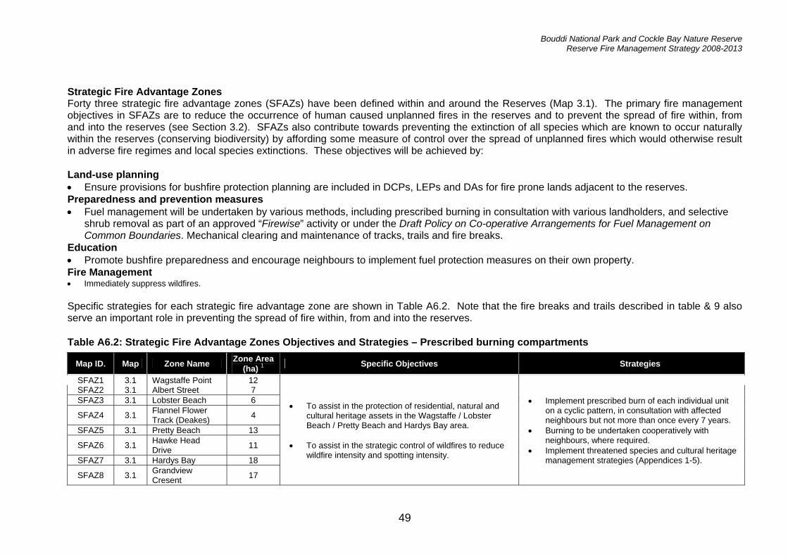
Bouddi National Park and Cockle Bay Nature Reserve Reserve Fire Management Strategy 2008-2013
49
Strategic Fire Advantage Zones Forty three strategic fire advantage zones (SFAZs) have been defined within and around the Reserves (Map 3.1). The primary fire management objectives in SFAZs are to reduce the occurrence of human caused unplanned fires in the reserves and to prevent the spread of fire within, from and into the reserves (see Section 3.2). SFAZs also contribute towards preventing the extinction of all species which are known to occur naturally within the reserves (conserving biodiversity) by affording some measure of control over the spread of unplanned fires which would otherwise result in adverse fire regimes and local species extinctions. These objectives will be achieved by: Land-use planning • Ensure provisions for bushfire protection planning are included in DCPs, LEPs and DAs for fire prone lands adjacent to the reserves. Preparedness and prevention measures • Fuel management will be undertaken by various methods, including prescribed burning in consultation with various landholders, and selective
shrub removal as part of an approved “Firewise” activity or under the Draft Policy on Co-operative Arrangements for Fuel Management on Common Boundaries. Mechanical clearing and maintenance of tracks, trails and fire breaks.
Education • Promote bushfire preparedness and encourage neighbours to implement fuel protection measures on their own property. Fire Management • Immediately suppress wildfires. Specific strategies for each strategic fire advantage zone are shown in Table A6.2. Note that the fire breaks and trails described in table & 9 also serve an important role in preventing the spread of fire within, from and into the reserves. Table A6.2: Strategic Fire Advantage Zones Objectives and Strategies – Prescribed burning compartments
Map ID. Map Zone Name Zone Area (ha) 1 Specific Objectives Strategies
SFAZ1 3.1 Wagstaffe Point 12 SFAZ2 3.1 Albert Street 7 SFAZ3 3.1 Lobster Beach 6
SFAZ4 3.1 Flannel Flower Track (Deakes) 4
SFAZ5 3.1 Pretty Beach 13
SFAZ6 3.1 Hawke Head Drive 11
SFAZ7 3.1 Hardys Bay 18
SFAZ8 3.1 Grandview Cresent 17
• To assist in the protection of residential, natural and cultural heritage assets in the Wagstaffe / Lobster Beach / Pretty Beach and Hardys Bay area.
• To assist in the strategic control of wildfires to reduce wildfire intensity and spotting intensity.
• Implement prescribed burn of each individual unit on a cyclic pattern, in consultation with affected neighbours but not more than once every 7 years.
• Burning to be undertaken cooperatively with neighbours, where required.
• Implement threatened species and cultural heritage management strategies (Appendices 1-5).

Bouddi National Park and Cockle Bay Nature Reserve Reserve Fire Management Strategy 2008-2013
50
Map ID. Map Zone Name Zone Area (ha) 1 Specific Objectives Strategies
SFAZ9 3.1 MacDonald Street 9 SFAZ10 3.1 Putty Beach Drive 8
SFAZ11 3.1 Jacqueline Ave (west) 1
SFAZ12 3.1 Putty Beach Catchment 61
SFAZ13 3.1 Killcare Heights Lookout 2
• To assist in the protection of residential, natural and cultural heritage assets in the Putty Beach, Killcare Heights area including park facilities at Putty Beach precinct and Bouddi Coastal Walk.
• To assist in the strategic control of wildfires to reduce wildfire intensity and spotting intensity.
SFAZ14 3.1 Stroms Track 7 SFAZ15 3.1 The Scenic Road 9
SFAZ16 3.1 Mount Bouddi Rd (West) 3
SFAZ17 3.1 Mount Bouddi Rd (East) 4
• To assist in preventing fires entering or exiting Bouddi National Park.
• To strengthen The Scenic Rd and Mt Bouddi Rd as a fire control advantage to assist in preventing fires spreading from NW Ridge and MacMasters Ridge Bouddi Grand Deep Land Management Zone.
SFAZ18 3.1 Dunlop Estate 32
SFAZ19 3.1 Little Beach 3
• To assist in the protection of residential, natural and cultural heritage assets in the Bombi Rd and Grahame Dr area.
• To assist in the strategic control of wildfires to reduce
wildfire intensity and spotting intensity.
• Implement prescribed burn of each individual unit on a cyclic pattern, in consultation with affected neighbours but not more than once every 7 years.
• Burning to be undertaken cooperatively with neighbours, where required.
• Implement threatened species and cultural heritage management strategies (Appendices 1-5).

Bouddi National Park and Cockle Bay Nature Reserve Reserve Fire Management Strategy 2008-2013
51
Map ID. Map Zone Name Zone Area (ha) 1 Specific Objectives Strategies
SAFZ20 3.1 Grahame Drive 25 SFAZ21 3.1 South Pacific 11
SFAZ22 3.1 Mourawaring Point 26
SFAZ23 3.1 Beachview 1
SFAZ24 3.1 Malonys 3
• To assist in the protection of residential, natural and cultural heritage assets in the MacMasters Beach area.
• To assist in the strategic control of wildfires to reduce
wildfire intensity and spotting intensity.
• Implement prescribed burn of each individual unit on a cyclic pattern, in consultation with affected neighbours but not more than once every 7 years.
• Burning to be undertaken cooperatively with neighbours, where required.
• Implement threatened species and cultural heritage management strategies (Appendices 1-5).
• Implement prescribed burn of each individual unit on a cyclic pattern, in consultation with affected neighbours but not more than once every 7 years.
• Burning to be undertaken cooperatively with neighbours, where required.
• Implement threatened species and cultural heritage management strategies (Appendices 1-5).
• Caution needs to be taken in interpreting thresholds, as some areas to the north and south of Little Beach are located on sand and better described as Coastal Sand Apple – Blackbutt Forest rather than Coastal Narrabeen Moist Forest.
SFAZ25 3.1 Damian Drive 8
SFAZ26 3.1 McMasters Ridge East 27
SFAZ27 3.1 Karuk Rd 43
SFAZ28 3.1 McMasters Ridge West 19
SFAZ29 3.1 North West Ridge 13 SFAZ30 3.1 Turkey Track 10 SFAZ31 3.1 Currong 22
• To assist in the protection of residential, natural and cultural heritage assets in the Bensville area.
• To assist in the strategic control of wildfires to reduce wildfire intensity and spotting intensity, particularly moving in a NW direction towards the Scenic Rd.
• Implement prescribed burn of each individual unit on a cyclic pattern, in consultation with affected neighbours but not more than once every 7 years.
• Burning to be undertaken cooperatively with neighbours, where required.
• Implement threatened species and cultural heritage management strategies (Appendices 1-5).

Bouddi National Park and Cockle Bay Nature Reserve Reserve Fire Management Strategy 2008-2013
52
Map ID. Map Zone Name Zone Area (ha) 1 Specific Objectives Strategies
SFAZ32 3.1 Pomona Road 48
• Implement prescribed burn of each individual unit on a cyclic pattern, in consultation with affected neighbours but not more than once every 7 years.
• Burning to be undertaken cooperatively with neighbours, where required.
• Implement threatened species and cultural heritage management strategies (Appendices 1-5).
SFAZ33 3.1 The Triangle Killcare Heights 6
SFAZ34 3.1 Wards Hill North 5 SFAZ35 3.1 Wards Hill Road 3 SFAZ36 3.1 Fletchers Glen 12 SFAZ37 3.1 Rocky Point 4 SFAZ38 3.1 Rileys Bay 43 SFAZ39 3.1 Fisherman's Pde 23 SFAZ40 3.1 Awinya Close 10
SFAZ41 3.1 Daleys Point North 16
SFAZ42 3.1 Daleys Point South 15
• To assist in the protection of residential, natural and cultural heritage assets in the Daleys Pt, Empire Bay and Killcare Heights area.
• To assist in the strategic control of wildfires to reduce wildfire intensity and spotting intensity, particularly moving in a NW direction towards Wards Hill Rd.
• Implement prescribed burn of each individual unit on a cyclic pattern, in consultation with affected neighbours but not more than once every 7 years.
• Burning to be undertaken cooperatively with neighbours, where required.
• Implement threatened species and cultural heritage management strategies (Appendices 1-5).

Bouddi National Park and Cockle Bay Nature Reserve Reserve Fire Management Strategy 2008-2013
53
Table A6.3 Strategic Fire Advantage Zones Objectives and Strategies – Fire Breaks
Map ID. Map Zone Name Zone Area (ha) 1 Specific Objectives Strategies
FB 1 3.1 Cockle Bay Fire Break 0.5
• To assist in the protection of residential assets along Empire Bay Road.
• To assist in the strategic control of wildfires to reduce wildfire intensity and spotting intensity.
• Maintain existing fire break by slashing , tritter or underscrubbing as required
• Maintain Cat 9 access
FB 2
3.1 Beachview Esp Fire Break (Malonys)
802 • To provide safe access for fire agency crews and to assist in the protection of assets between Beachview Esp, Namatjira Dr & MacMaster Pde.
• Maintain existing fire break by slashing , tritter or underscrubbing as required
• Maintain Cat 9 access • Consider the requirments to extend fire break to the SE as
a result of new developments. FB 3 3.1 Killcare Heights Fire
Break (Baden St) 259 • To provide safe access for fire agency crews and to assist in
the protection of assets near Baden St & Jacqueline Ave • Maintain existing fire break by slashing , tritter or
underscrubbing as required FB 4 3.1 Wards Hill Fire
Break 51 • To provide safe access for fire agency crews and to assist in
the protection of assets in Wards Hill Rd. • Maintain existing fire break by slashing , tritter or
underscrubbing as required • Maintain walking access only
1 All areas generated by GIS and hence may differ slightly from gazetted areas.
• Consideration will be given to the construction of fire breaks to the west of properties at Grahame Drive, MacMasters Beach, and east of properties at Bundaleer Crescent / Yowie Close, Bensville.

Bouddi National Park and Cockle Bay Nature Reserve Reserve Fire Management Strategy 2008-2013
54
Land Management Zones Sixteen Land Management Zones (LMZs) have been defined within and around the Reserves (Map 3.1). The primary fire management objectives in LMZs are to prevent the extinction of all species which are known to occur naturally within the reserves (conserve biodiversity) and to protect Aboriginal sites, historic heritage sites and other culturally significant features from fire (see Section 1.2). Except where noted otherwise, these objectives will be achieved by:
• suppressing bushfires and, where necessary, conducting prescribed burns to maintain fire regimes within the biodiversity thresholds specified in Appendix 1, 2, & 3; and
• Implementing the threatened species and cultural heritage management guidelines specified in Appendix 2 to 5 in locations where threatened species and cultural heritage sites are known or likely to occur.
Table A6.3 describes the specific fire management objectives and strategies to be applied in each land management zone. Table A6.4 Land Management Zones Objectives and Strategies
Area (ha) by Vegetation Threshold Class1
(Table 1) Map ID. Map Zone Name Zone
Area (ha) A B C D E
Threatened Fauna
Guidelines (Table 3)
Threatened Flora
Guidelines (Table 2)
Cultural Heritage
Guidelines (Tables 4,5)
Strategies
LMZ1 3.1 Little Box Head 50 0.0 32.6 14.2 0.2 - - AH1
LMZ2 3.1 Iron Ladder 19 0 15.2 0.7 0.0 - - -
LMZ3 3.1 Little Tallow Beach 27 0 5.2 17.7 0.4 FA14, FA21 - -
LMZ4 3.1 Tallow Beach 47 0 13.9 28.4 0.1 - - -
LMZ5 3.1 Bullimah Spur 48 0 35.7 7.1 0.0 FA21 - -
LMZ6 3.1 Bouddi Grand Deep 172 8.6 146.5 7.2 0.8
FA2, FA8, FA13, FA14, FA19, FA29
FL1 AH2, HH2, HH3, HH4
• Suppress bushfires and conduct prescribed burns as appropriate to maintain fire regimes within the vegetation thresholds specified in Appendix 1.

Bouddi National Park and Cockle Bay Nature Reserve Reserve Fire Management Strategy 2008-2013
55
Area (ha) by Vegetation Threshold Class1
(Table 1) Map ID. Map Zone Name Zone
Area (ha) A B C D E
Threatened Fauna
Guidelines (Table 3)
Threatened Flora
Guidelines (Table 2)
Cultural Heritage
Guidelines (Tables 4,5)
Strategies
LMZ7 3.1 Caves Gully 101 2.7 71.9 22.9 3.1
FA8, FA14, FA18, FA21, FA28, FA29
- HH3
LMZ8 3.1 Caves Bay 53 0 5.0 37.1 1.5 - - -
LMZ9 3.1 Bombi Moors 33 0 4.1 26.7 0.0 FA2 - -
LMZ10 3.1 Old Quarry Trail 25 0 13.2 5.3 6.2 FA21 - AH1
LMZ11 3.1 81 18 0 6.2 9.3 0.0 FA21 - -
LMZ12 3.1 78 14 0 9.0 3.6 0.0 FA2, FA15, FA29 - -
LMZ13 3.1 Mourawaring South 11 0 5.1 4.8 0.8 - - -
LMZ14 3.1 Mourawaring Moors 15 0 0.4 13.7 0.8 - - -
LMZ15 3.1 Little Valley 34 8.3 25.4 0.0 0.0 FA18, FA28 - -
• Implement the threatened species management strategies specified in Appendix 2 & 3.
• Implement the
cultural heritage management strategies specified in Appendix 4 & 5.
LMZ16 3.1 Cockle Bay Land Management 65 0 37 0 28
FA2, FA9, FA13, FA14, FA17, FA18, FA19, FA20, FA22, FA30
- -
• Maintain fire regime at the upper end (35yrs) of vegetation thresholds.
• Suppress all bushfires
1 All areas generated by GIS and hence may differ slightly from gazetted areas.

Bouddi National Park and Cockle Bay Nature Reserve Reserve Fire Management Strategy 2008-2013
56
APPENDIX 7: STANDARD OPERATIONAL GUIDELINES Table A7: Standard operational guidelines
Issue Guidelines
Aerial water bombing
• The use of bombing aircraft should support containment operations by aggressively attacking hotspots and spot-overs.
• The use of bombing aircraft without the support of ground-based suppression crews should be limited to very specific circumstances.
• Where practicable, foam should be used to increase the effectiveness of the water. • Ground crews must be alerted to water bombing operations. • Where practicable, fresh water should be used for water bombing in preference to salt water.
Aerial ignition
• Aerial ignition may be used during backburning or fuel reduction operations where practicable, but only with the prior consent of a senior NPWS officer.
• Use incendiaries to rapidly progress backburns downslope where required. Backburning
• Temperature and humidity trends must be monitored carefully to determine the safest times to implement backburns. Generally, when the Fire Danger Index (FDI) is very high or greater, backburning should begin when the humidity begins to rise in the late afternoon or early evening. With a lower FDI, backburning may be safely undertaken during the day.
• Where practicable, clear a 1 m radius around dead and fibrous-barked trees adjacent to containment lines before backburning, or wet down these trees as part of the backburn ignition.
• Avoid ignition of backburns at the bottom of slopes where a long and intense upslope burn is likely.
Command & control
• The first combatant agency on site may assume control of the fire, but then must ensure that the relevant land management agency is notified promptly.
• On the arrival of other combatant agencies, the initial incident controller will consult with regard to the ongoing command, control and incident management team requirements as per the relevant BFMC plan of operations.
Containment lines
• Construction of new containment lines should be avoided, where practicable, except where they can be constructed with minimal environmental impact. New containment lines require the prior consent of a senior NPWS officer.
• Where practicable, containment lines should be stabilised and rehabilitated as part of the wildfire suppression operation.
• All containment lines not required for other purposes should be closed at the cessation of the incident.
• All personnel involved in containment line construction should be briefed on both natural and cultural heritage sites in the location.
Earthmoving equipment
• Earthmoving equipment may be used only with the prior consent of a senior NPWS officer, and then only if the probability of its success is high.
• Earthmoving equipment must be always guided and supervised by an experienced officer, and accompanied by a support vehicle. When engaged in direct or parallel attack, this vehicle must be a fire fighting vehicle.
• Containment lines constructed by earthmoving equipment should consider the protection of drainage features, observe the Threatened Species and Cultural Heritage Operational Guidelines, and be surveyed, where possible, to identify unknown cultural heritage sites.
• Restrict the use of earthmoving equipment in environmentally sensitive areas including slopes greater than 18 degrees, and areas of Acid Sulphate Soils.
• Earthmoving equipment should be washed down, where practicable, before entering NPWS estate.
Fire advantage recording
• All fire advantages used during wildfire suppression operations must be mapped and, where relevant, added to the database.
Fire suppression chemicals
• Wetting and foaming agents (surfactants) are permitted for use in wildfire suppression. • The use of fire retardant is permitted only with the prior consent of the senior NPWS officer, and
should be avoided where reasonable alternatives are available. • Exclude the use of surfactants and retardants within 50 m of rainforest, watercourses, dams
and swamps. • Areas where fire suppression chemicals are used must be mapped, and the names of the
products must be recorded. • The Threatened Species Operational Guidelines are to be observed.

Bouddi National Park and Cockle Bay Nature Reserve Reserve Fire Management Strategy 2008-2013
57
Issue Guidelines
Response & Mop-up • Vehicles should avoid areas with waterlogged soils, which appear to have dry surface
conditions. This particularly applies to Cockle Bay NR. • Subject to risk, stags, trees with hollows, and fallen debris will be protected. • Soils with high organic matter content have the potential for re-ignition. Sustained periods of
patrol are required in these environments. This is of particular concern in Cockle Bay NR. Rehabilitation
• Where practicable, containment lines should be stabilised and rehabilitated as part of the wildfire suppression operation.
• Where necessary, undertake pest control programs to prevent the invasion and spread of pest species.
Smoke management
• The potential impacts of smoke and possible mitigation tactics must be considered when planning for wildfire suppression and prescribed burning operations.
• If smoke becomes a hazard on local roads or highways, the police and relevant media must be notified.
• Smoke must be managed in accordance with RTA traffic management guidelines. Visitor management
• The reserve may be closed to the public during periods of extreme fire danger or during wildfire suppression operations.

58

Bouddi National Park and Cockle Bay Nature Reserve Reserve Fire Management Strategy 2008-2013
59
APPENDIX 8: FIRE TRAIL & ROAD REGISTER Table A8: fire trail and road register
Map No Name Current accessibility
Proposed BFCC Class
Strategy Tenure1 Length (m)
3.2 Bombi Rd North Cat 1 Essential GCC 334 3.2 Bombi Rd South Cat 1 Essential GCC 231 3.2 Grahame Drive Cat 1 Essential NPWS/GCC 417 3.2 Hawke Head Drive Cat 1 Essential GCC/NPWS 1789 3.2 Mount Bouddi Road Cat 1 Essential NPWS 709 3.2 Putty Beach Drive Cat 1 Essential
• Undertake annual inspection of road condition and maintenance requirements. • Maintenance in accordance with Asset Maintenance System • Liaise with Gosford City Council regarding joint maintenance agreement.
NPWS 512
3.2 72 Trail (Mourawaring Moor) Cat 9 Important NPWS 303
3.2 78 Trail (Bombi Moor) Cat 9 Important NPWS 347
3.2 81 Trail (Bombi Moor) Cat 9 Important NPWS 734
3.2 Bombi Moor Trail Cat 9 Important NPWS 1369
3.2 Box Head Trail (Leos Arm) Cat 9 Important NPWS 288
3.2 Cockle Bay Trail Cat 9 Important
• Undertake annual inspection of trail condition and maintenance requirements. • Maintenance in accordance with Asset Maintenance System • Consider the requirements to upgrade Box Head Trail (Leos Arm) to Cat 7 standard
NPWS 289
3.2 Daleys Point Aboriginal Site Access Trail Cat 7 Important NPWS
267
3.2 Daleys Point Trail Cat 7 Important
• Undertake annual inspection of trail condition and maintenance requirements. • Maintenance in accordance with Asset Maintenance System • Consider the requirements to upgrade to Essential standard. NPWS/GCC 2145
3.2 Fishermans Trail Cat 7 Important NPWS 1081
3.2 Hardys Bay Trail (Lot 5) Cat 9 Important NPWS/PP 659
3.2 Killcare Trail Cat 9 Important
• Undertake annual inspection of trail condition and maintenance requirements. • Maintenance in accordance with Asset Maintenance System • Consider the requirements to upgrade Hardys Bay Trail to Cat 7 standard. NPWS 502
3.2 Little Beach Trail Cat 7 Important
• Undertake annual inspection of trail condition and maintenance requirements. • Maintenance in accordance with Asset Maintenance System • Consider the requirements to upgrade to Essential standard. NPWS
565
3.2 Little Valley Trail Cat 7 Important • Undertake annual inspection of trail condition and maintenance requirements. • Maintenance in accordance with Asset Maintenance System NPWS 1728
3.2 MacMasters Ridge Trail Cat 1 Important
• Undertake annual inspection of trail condition and maintenance requirements. • Maintenance in accordance with Asset Maintenance System • Consider the requirements to upgrade to Essential standard. NPWS
1666
3.2 Mourawaring Moor Cat 9 Important • Undertake annual inspection of trail condition and maintenance requirements. NPWS 733

Bouddi National Park and Cockle Bay Nature Reserve Reserve Fire Management Strategy 2008-2013
60
Map No Name Current accessibility
Proposed BFCC Class
Strategy Tenure1 Length (m)
Trail • Maintenance in accordance with Asset Maintenance System.
3.2 North West Ridge Trail Cat 9 Important NPWS 797
3.2 Old Quarry Trail Cat 9 Important NPWS 1009 3.2 Old Wagstaffe Trail Cat 9 Important NPWS 1487 3.2 Oyster Lease Trail Cat 9 Important NPWS 227 3.2 Rocky Point Trail Cat 7 Important NPWS 889
3.2 Second Point (Mourawaring) Trail Cat 9 Important NPWS 532
3.2 South Pacific Trail Cat 9 Important NPWS 147 3.2 Stroms Trail Cat 9 Important NPWS 2099 3.2 Tallow Beach Trail Cat 7 Important NPWS 1125
3.2 Third Point (Bombi) Trail Cat 9 Important NPWS 704
3.2 Turkey Trail Cat 9 Important
• Undertake annual inspection of trail condition and maintenance requirements. • Maintenance in accordance with Asset Maintenance System • Consider the requirements to upgrade Old Wagstaffe Trail to Cat 7 standard • Consider the requirements to upgrade Tallow Beach Trail to Essential standard.
NPWS 663

APPENDIX 9: BUSHFIRE BEHAVIOUR POTENTIAL Fire behaviour is the manner in which a fire reacts to the variables climate, topography and vegetation. The accurate prediction of fire behaviour is very complex. Listed below are the methods for developing a bushfire behaviour model that incorporates terrain (slope, aspect and altitude) and fuel (vegetation) for the Reserves. Terrain For the purposes of modelling fire behaviour, two slope classes are derived: slopes of less than 10 degrees and greater than 10 degrees. This allows for a convenient division of the Reserves into flat /level and hilly/ steep divisions for modelling, directly representing increasing bushfire intensity and rate of spread. Aspect has a significant influence on fire behaviour. Three aspect classes were selected: north-west (>225 to 45 degrees), east (>45 to 135 degrees), and south (which were then ranked according to their influence on fire intensity and rate of spread. Fire intensity and rate of spread tends to increase with the drier aspects. In the Sydney Region this tends to be the north, north-west and western slopes. Vegetation on these slopes is generally drier than the vegetation on the southern and eastern slopes. High Fire Danger Indices (FDI) occur on the western and to a lesser degree northern aspects in the Sydney Region (Bradstock et al. 1998). Fuel The vegetation within the Reserves ranges from sedgeland, mangroves, grassland, open-heath, closed-heath, low open woodland, woodland to open forest. These groups provide an indication of the continuity, structure, quantity of fuels and the frequency of fuel availability during the average bushfire season. For the purposes of modelling bushfire behaviour the vegetation types were ranked according to their potential to influence fire intensity and rate of spread, refer to Table A10.1. Shrubland is concentrated on gradual to intermediate slopes with a strong coastal influence. Open forest is more prevalent on steep slopes which have a northerly facing aspect, while woodland is found over the full range of environmental variables. The results of a fuel sampling study undertaken within the Sydney Basin indicate that shrubland (33.25 t/ha) had the potential to accumulate the highest amounts of total fine fuels after about 30 years, followed by woodland (23.57 t/ha), open forest (18.37 t/ha), grassland (10.1 t/ha) and rainforest (8 t/ha) in that order (Conroy, 1993). For grassland and wet forest groups there appears to be very little correlation between age since fire and fuel accumulation. Other factors such as drought and growing season are likely to play a much greater factor in determining fuel loads. Slope, aspect and fuel groups may be combined to provide a model of the bushfire behaviour potential for the Reserves (Map 3.3). The model does not take into account fire weather however climatic differences are represented indirectly through the fuel and aspect classes. The model has been developed according to Figure 6 and classes then assigned based on the output values of this model (Tables A10.1 & A10.2). These classes are a simple arithmetic division of the output range and should be viewed as relative classes for the Reserves rather than stand alone. For instance a very high class on the Reserves may not be equivalent to a similar class in another area showing drier characteristics.

Bouddi National Park and Cockle Bay Nature Reserve Reserve Fire Management Strategy 2008-2013
62
+ + = Figure 6 Calculations of bushfire behaviour potential Table A9.1 Parameters used to calculate the value of bushfire behaviour potential Aspect North
316°-45° East
46°-135° South
136° - 225° West
226°-315° Slope <10° >10° <10° >10° <10° >10° <10° >10° Shrubland 4 2 4 2 3 2 1 1 Woodland 6 3 6 3 5 2 2 1 Open Forest 7 3 7 3 6 3 4 1 Grassland - - - - - - - - Table A9.2 Bushfire risk analysis for Bouddi National Park and Cockle Bay Nature Reserve.
Class Value Locations Very High 1-2 Westerly facing aspects of Box Head to Wagstaffe Point, Daleys Point, Rocky Point,
Bullimah and Bouddi Spurs, North West Ridge, MacMasters Trail and Mourawaring Moors. High 3-4 Areas in the general vicinity of Hawke Head Drive, Rileys Bay, Bombi Point, Mourawaring
Point and northerly facing slopes of Bouddi Ridge. Medium 5-6 Along Stroms Track, Tallow Beach and the SE portion of Cockle Bay Nature Reserve. Low 7-8 Cockle Bay Nature Reserve.
Slope Classes
(2)
Aspect Classes
(4)
Fuel Classes (4)
Bushfire Behaviour Potential
Class (0-8)

Bouddi National Park and Cockle Bay Nature Reserve Reserve Fire Management Strategy 2008-2013
63
APPENDIX 10: GLOSSARY The definitions described below are based on the Australian Fire Authorities Council (AFAC) Glossary of Rural Fire Terminology (1996) and the NPWS Fire Management Manual (2006). Aerial Detection Discovering, locating and reporting of fires from aircraft.
Aerial Fuels The standing and supporting combustibles not in direct contact with the ground and consisting mainly of foliage, twigs, branches, stems, bark and creepers.
AHIMS Aboriginal Heritage Information Management System (AHIMS). A database for all Aboriginal objects, Aboriginal places and other Aboriginal heritage values in NSW that have been reported to the NPWS.
Aspect The direction towards which a slope faces, e.g. north-east. Slopes on a west to north-westerly aspect are the most hazardous during fire fighting operations.
Asset Protection Zone (APZ) A zone which is proven to provide effective protection from radiation damage to both assets and firefighters in all but the most extreme wildfire events.
Assets at Risk
The natural resources or improvements that may be jeopardised if a fire occurs. Examples include: threatened species habitat, rainforests, forestry coups, human built structures or infrastructures, park information signs, transmission poles etc. and may also include scenic values. For the fire manager it may also include natural values that may be threatened by a fire (e.g. water catchment quality).
Backburning A fire started intentionally along the inner edge of a fireline to consume the fuel in the path of a wildfire.
Buffer A strip or block of land on which the fuels are reduced to provide protection to surrounding lands.
Burning Program All the prescribed burns scheduled for a designated area over a nominated period of time.
Bush Fire Management Zone (BFMZ)
Management areas where a specified fore management operation objective, strategy and performance Indicator has been developed.
Bush Fire Management Zone Area
Management areas of a variable size that define containment blocks in the event of a wildfire. Alternatively they are also designated as areas of specific ecosystem types defined by fire management authorities for monitoring and prescribed burning for natural heritage management
Coarse Fuels Dead woody material, greater than 25mm in diameter, in contact with the soil surface (fallen trees and branches).
Controlled Burning see Prescribed Burning.
Crown Fire A fire burning in the crowns of trees and usually supported by fire in ground fuels. It is a fast travelling fire that usually consumes all available fuels in its path.
Drought Index A numerical value, such as the Keetch-Byram Drought Index, reflecting the dryness of soils, deep forest litter, logs and living vegetation.
Ecosystem The interacting system of a biological community, both plant and animal, and its non living surroundings
Edge Burning A term used to describe perimeter burning of an area in mild conditions prior to large scale prescribed burning. This practice is used to strengthen buffers and to reduce mop-up operations.
Fine Fuels Grass, leaves, bark and twigs less than 6mm in diameter.
Fire
The chemical reaction between fuel, oxygen and heat. Heat is necessary to start the reaction and once ignited, fire produces its own heat and becomes self-supporting. Removal of any one of the three elements of fuel, oxygen and heat will extinguish a fire.

Bouddi National Park and Cockle Bay Nature Reserve Reserve Fire Management Strategy 2008-2013
64
Fire Behaviour The manner in which a fire reacts to the variables of fuel, weather and topography. Changes in any of these variables with result in a change in the fires behaviour.
Fire Break Any natural or constructed discontinuity in a fuel bed used to segregate, stop and control the spread of a wildfire, or to provide a fireline from which to suppress a fire.
Fire Danger Index (FDI) A relative number denoting an evaluation of rate of spread, or suppression difficulty for specific combinations of fuel, fuel moisture and wind speed.
Fire Extent
The area burnt by a wildfire, measured in hectares. Within that area there will be "islands" of unburnt vegetation (these islands are generally included in the total fire extent).
NB: it is preferable that fire effect only part of a vegetation community at any one time so that nearby areas of more mature plants may provide a seed source for recolonisation and animals will have suitable unburnt habitat in order to seek shelter and forage.
Fire Front The part of a fire where the rate of spread, flame height and intensity are greatest, usually when burning downwind or upslope.
Fire Intensity The rate of energy released per unit length of fire front. This is usually expressed as kilowatts per metre (kW/m).
Fire Management All activities associated with the management of fire-prone land, including the use of fire to meet land management goals and objectives.
Fire Perimeter The entire outer boundary of a fire area.
Fire Regime
The history of fire in a particular vegetation type or area including the frequency, intensity and season of burning (season in this context refers to the time of the year in which the fire occurred). It may also include proposals for the use of fire in a given area.
Fire Season
The period(s) of the year during which fires are likely to occur, spread and do sufficient damage to warrant organised fire control. In New South Wales the core fire season is from 1st October to the 31st March of the following year.
At the regional scale, the season may be introduced or extended by one month dependant upon the prevailing weather conditions, drought indexes and number of wildfire's that may already be burning within that area.
Fire Storm Violent convection caused by a large continuous area of intense fire; often characterised by destructively violent surface indrafts, a towering convection column, long distance spotting, and sometimes by tornado-like whirlwinds.
Flame Height The vertical distance between the tip of the flame and ground level, excluding higher flame flashes. Expressed in vertical metres.
Fuel Any material such as grass, bark, leaf litter and living vegetation which can be ignited and sustains a fire. Fuel is usually measured in tonnes per hectare of dry weight.
Fuel Arrangement A general term referring to the spacing and arrangement of fuel in a given area.
Fuel Bed The arrangement and vertical profile of all readily combustible materials lying on the ground.
Fuel Load The oven dry weight of fuel per unit area. Commonly expressed as tonnes per hectare.
Fuel Management Modification of fuels by prescribed burning, manual removal, slashing, grazing, or other means. The objective is to reduce the fuel thereby reducing the risk posed by wildfire's.
Fuel Type An identifiable association of fuel elements of distinctive species, form, size, arrangement, or other characteristics that will cause predictable rate of spread or difficulty of control under specified weather conditions.

Bouddi National Park and Cockle Bay Nature Reserve Reserve Fire Management Strategy 2008-2013
65
Habitat
A physical portion of the environment that is inhabited by an organism or population of organisms. A habitat is characterised by a relative uniformity of the physical environment and fairly close interaction of all the biological species involved. Organisms within a given habitat will express a level of co-dependency upon one-another. The loss of the physical characteristics of a given habitat can have sever and long term detrimental effects upon the organisms living in that habitat.
Hazard Reduction see Fuel Management
HHIMS Historic Heritage Information Management System (HHIMS) manages information on around 9000 heritage items, most of which are in national parks and reserves.
Land Management Zone (LMZ)
Land Management Zones conserve natural and cultural heritage items which may be damaged or destroyed by inappropriate fire regimes
Island An unburnt area within a fire perimeter. Islands are critical for species survival and recruitment after a wildfire event.
Keetch-Byram Drought Index (KBDI)
A numerical value reflecting the dryness of soils, deep forest litter, logs and living vegetation, and expressed as a scale from 0 - 200 points. When 100 points has been reached in an area, that area is said to be in drought.
NPWS The National Parks and Wildlife Service of New South Wales.
NSWFB The New South Wales Fire Brigades.
Prescribed Burning The controlled application of fire under specified environmental and weather conditions to a predetermined area and at the time, intensity, and rate of spread required to attain planned resource management objectives.
Rate of Spread The forward progress per unit time of the head of the fire or another specified part of the fire perimeter.
RFS The Rural Fire Service.
RIPs Region Incident Procedures containing important contact information, procedures for the detection and response to an incident, and fire preparedness guidelines.
Scorch Height The height above ground level up to where foliage has been browned by a fire. This height is roughly ten times the actual flame height of the fire.
Service, the The National Parks and Wildlife Service of New South Wales.
SF State Forests of New South Wales.
Slip-on Unit
A fire fighting unit that can be placed on to the back of a four wheel drive vehicle to convert it to a fire tanker.
Depending upon the units water carrying capacity, a four wheel drive tray top vehicle could be converted to Category 2,7 or 9 fire tankers in a very short space of time.

Bouddi National Park and Cockle Bay Nature Reserve Reserve Fire Management Strategy 2008-2013
66
Soil Dryness Index (SDI) See Drought Index
Southern Oscillation Index (SOI)
Calculated from the monthly or seasonal fluctuations in the air pressure difference between Tahiti and Darwin. Sustained negative values of the SOI often indicate El Niño episodes. Positive values of the SOI are associated with stronger Pacific trade winds and warmer sea temperatures to the north of Australia, popularly known as a La Niña episode.
Spot Fire Isolated fires started ahead of the main fire by sparks, embers or other ignited material, sometimes to a distance of several kilometres.
Strategic Fire Advantage Zone (SFAZ)
Strategic Fire Advantage Zones (SFAZ) assist in the containment of wildfires to provide safe access to bush fire fighters and to assist with the achievement of a fire regime which is consistent with reserve management objectives. The zone is located in an area which is effective in reducing wildfire intensity and spotting potential and is therefore proven to be effective in assisting with the containment of wildfires within a defined area
Striker A small four wheel drive fire tanker capable of carrying from 400 to 600 litres of water for fire fighting purposes. Also known as a Category 9 Fire Tanker.
Structure Fire A fire burning part, or all of any building, shelter, or other human made construction.
Tanker
A mobile firefighting vehicle equipped with a water tank, pump, and the necessary equipment for spraying water and/or foam on wildfire's.
Under NSW Dept. of Rural Fire Service guidelines, bush fire fighting tankers have been designated into nine 'Categories' delineating water carrying capacity and whether the unit is two or four wheel drive capable.
Topography The surface features of a particular area or region, ie the lay of the land, and includes mountains, rivers etc.
Unplanned Fire see Wildfire
Urban/Rural Interface The line, area, or zone where structures and other human development adjoin or overlaps with undeveloped bushland. Also known as the urban/bush interface, urban interface or just the interface.
Wildfire An unplanned fire. A generic term which includes grass fires, forest fires and scrub fires.

Bouddi National Park and Cockle Bay Nature Reserve Reserve Fire Management Strategy 2008-2013
67
NATIONAL PARKS AND WILDLIFE SERVICE 43 Bridge Street Hurstville NSW Australia 2220
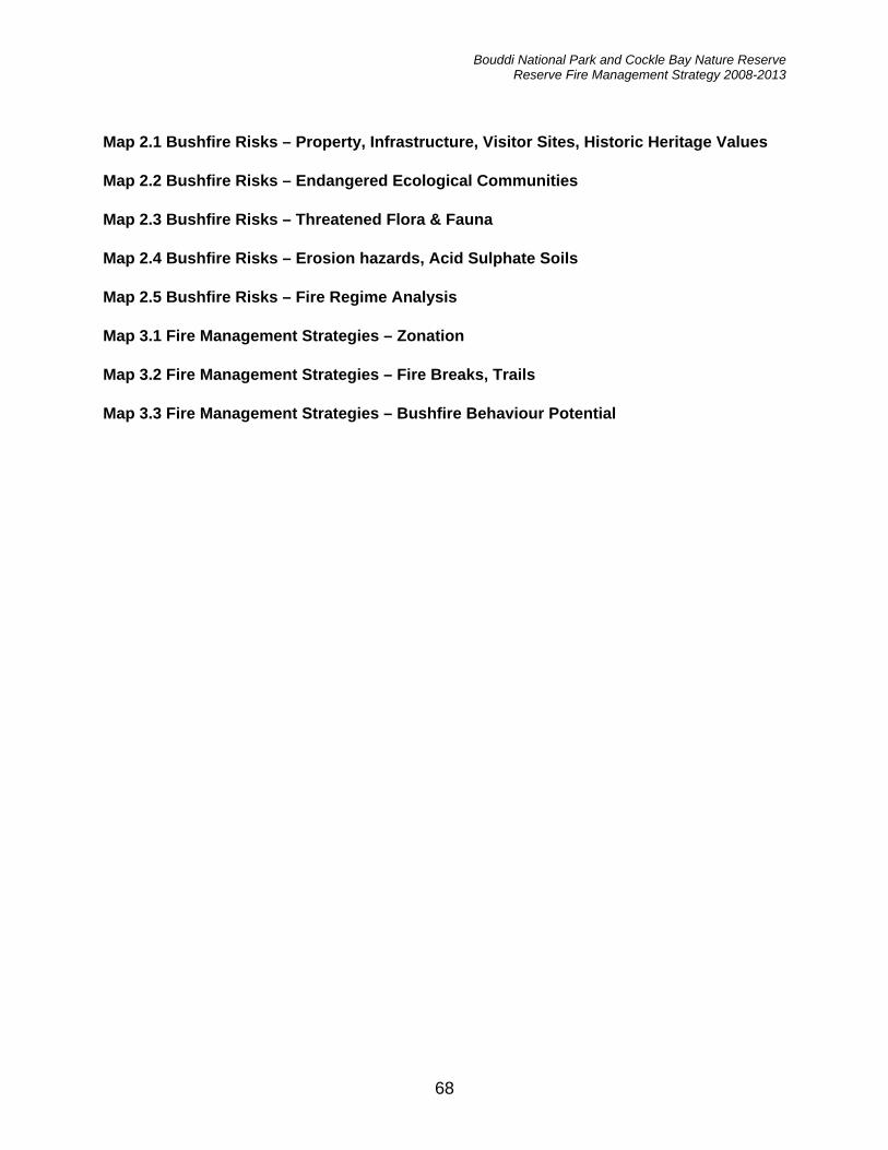
Bouddi National Park and Cockle Bay Nature Reserve Reserve Fire Management Strategy 2008-2013
68
Map 2.1 Bushfire Risks – Property, Infrastructure, Visitor Sites, Historic Heritage Values Map 2.2 Bushfire Risks – Endangered Ecological Communities Map 2.3 Bushfire Risks – Threatened Flora & Fauna Map 2.4 Bushfire Risks – Erosion hazards, Acid Sulphate Soils Map 2.5 Bushfire Risks – Fire Regime Analysis Map 3.1 Fire Management Strategies – Zonation Map 3.2 Fire Management Strategies – Fire Breaks, Trails Map 3.3 Fire Management Strategies – Bushfire Behaviour Potential

Map 2.1 Bushfi re Risks - Property, Infrastructure, Visitor Sites, Historic Heritage Values
��
��
��
��
����
��
��������
��
��������
������
��
��
��
��
��
��
��
����
����
�
�
�
�
�
�
�
�
�
�
�
��
��
��
����
����
��
��
��
��
��
��������
�����
���������
�������������
��������������
������
�������������
� � � � � � � � � �
������
���������������
�����
���������
���������
����������
��� ������!�"��
���������������
����������
#�����������������
������
�������
$��������
������$�������
��������������
��������������
%��������������
�� ��������
�������
$&'
$(
�)*$&*
�)&
�)*�)+
$,-��)(
$&+-�$&(-��)&-��),
$&.
$,(
�)+$,+
$.
$'-��)&-��),
�)*�)&
�)*
$&,
$&&�)*
$&/�)*
$&0$0
$,1$,,
$+-��)*
$,&$,1
$/
�)*
$*
�)* $&�)*�)*
$,*
�
�
��
������������� ���������� ���� ���������������
+(*111
+(*111
+(/111
+(/111
+('111
+('111
+(.111
+(.111
+(0111
+(0111
+*1111
+*1111
+*&111
+*&111
+*,111
+*,111
+*+111
+*+111
+*(111
+*(111
+**111
+**111
/,./
111 /,./111
/,.'
111 /,.'111
/,..
111 /,..111
/,.0
111 /,.0111
/,01
111 /,01111
/,0&
111 /,0&111
/,0,
111 /,0,111
/,0+
111 /,0+111
/,0(
111 /,0(111
������� ������ �� ���������� �������� �������� !"#� ����$���%&&'���������(���������� ������ ���� ��$����������������������������(�������� �� ���������� �������� �������� !"���� �������������������������������$� ����������� ������� �������� ��� �������������������������������)���������������� �����������
�
��
�
& &*+ � ,���� ���)���&2*1�111
������������� ���������� ���� ���������������
-� ������� ��� �� �"!��� � ���$���������� �"!��� � ����� ���.��/
���� �����0� ����� ���� ����
�� 0� ����! �
� ���������
� ����1�������
� 2��/��

Map 2.2 Bushfi re Risks - Endangered Ecological Communities
�������
������� �
���������� �
�������������
�������������
�������������� �
��������� �
�������
��
���������� �
���������
�����������������������
�� ����
����������
�������� �
��������
!��������� "�����
���
���������������
�����
������
� � � � � � � # �
�� ������� �
$�������
��������%��� ��������
$�&�����
��� '����
�������
�
�
��
������������� ���������� ���� ���������������
()*+++
()*+++
(),+++
(),+++
()-+++
()-+++
().+++
().+++
()/+++
()/+++
(*++++
(*++++
(*0+++
(*0+++
(*1+++
(*1+++
(*(+++
(*(+++
(*)+++
(*)+++
(**+++
(**+++
,1.,
+++ ,1.,+++
,1.-
+++ ,1.-+++
,1..
+++ ,1..+++
,1./
+++ ,1./+++
,1/+
+++ ,1/++++
,1/0
+++ ,1/0+++
,1/1
+++ ,1/1+++
,1/(
+++ ,1/(+++
,1/)
+++ ,1/)+++
������� ������ �� ���������� �������� �������� !"#� ����$���%&&'���������(���������� ������ ���� ��$����������������������������(�������� �� ���������� �������� �������� !"���� �������������������������������$� ����������� ������� �������� ��� �������������������������������)���������������� �����������
�
��
�
& &*+ � ,���� ���# ���02*+�+++
������������� ���������� ���� ���������������
������������������������ ��(���������������������������������� ������������������ ���!�$��$��-�.���!���$����/�0����1������ �������� ���!�� ���������!0����2�.�3��������3���� �����������3���� ����!0����!�����������3���� � 0� ���!�� �������3���� ����
3� ������� ��� �� �"!��� � ���$���������� �"!��� � �

��
����
������
��
��
��
��
��
��
����
��
��
����
����
����
��
����
����
��
��
��
��
��
��
����
�� ��
��������������
��������
��
��������������
��������
��
��
��
����������
����
��
��
����
����
��
��
��
��
��
��
��
��
��
��
��
��
��
��
��
��
��
��
��
��
��
��
��
��
����
��
��
��
��
��
������
��
��
��
��
��
��
��
����
������
������������
��
��
��
��
��
����
��
��
��
����
��
��
��
��
��
��
��
����
����
��
����
��
��
��
��
����
����
��
��
��
����
��
��
����
��
���� ����������
����
��������
��
��
��������������������������
��
��
����
��
��
��
��
��������
��
��
��
��
��
��������
�����
���������
����������������������
������
�������������
����������
��������
���������������
�����
��������
!���������
���������
"���������
���#������$�%��
���������������
����������
&�����������
����������
����
�����
���������
"�������������
��������������
"�������������
'����"���������
"�#��������
�������
()* ()*()*
()*()*()*
()*
()+()+ ()+
()+
()+
()*()*
()+
()+
()+
(),
()*
()+
()+()*
()+
()+
()+
()+
()+
()+
()+
()+ ()+
()+
()+
()+
()+
()*()*
()*
()-
()+.�(),
()+
()+(),
()+()*()+
()/()+
()+()0
()+
()-
(),
(),()0(),
(),
()0()0(),
()0()*()0
(),
(),()+
()0()/
()+(),
()/()0
()+()/()/ ()*
()0
()+()0
()0
()*
()*(),
()+(),
()/.�()0.�(),
()+()0
()*
()+
()*()+()0
()+()0
()+()0
()*("/ ("*
("*
�
�
��
������������� ���������� ���� ���������������
+-0111
+-0111
+-2111
+-2111
+-3111
+-3111
+-4111
+-4111
+-,111
+-,111
+01111
+01111
+0*111
+0*111
+0/111
+0/111
+0+111
+0+111
+0-111
+0-111
+00111
+00111
2/42111 2/42111
2/43111 2/43111
2/44111 2/44111
2/4,111 2/4,111
2/,1111 2/,1111
2/,*111 2/,*111
2/,/111 2/,/111
2/,+111 2/,+111
2/,-111 2/,-111
������� ������ �� ���������� �������� �������� !"#� ����$���%&&'���������(���������� ������ ���� ��$����������������������������(�������� �� ���������� �������� �������� !"���� �������������������������������$� ����������� ������� �������� ��� �������������������������������)���������������� �����������
�
��
�
& &*+ � ,���� �������*501�111
-� ������� ��� �� �"!��� � ���$���������� �"!��� � �
�� (���� ����������������� (���� ����������������
������������� ���������� ���� ���������������
Map 2.3 Bushfi re Risks - Threatened fl ora and fauna

Map 2.4 Bushfi re Risk - Erosion Hazards, Acid Sulphate Soils
����������
��� ���������
��������������
���������� �
���������������
���������
�������
��
����������
����� ���� �
���� ������������� �
� ����
�������� �
����������
�������
!������� � "������
��
������� ����� �
�����
������
� � � � # �
����������
$���� �
�������%�������������
$�&������
��'���
�������
�
�
��
������������� ���������� ���� ���������������
()*+++
()*+++
(),+++
(),+++
()-+++
()-+++
().+++
().+++
()/+++
()/+++
(*++++
(*++++
(*0+++
(*0+++
(*1+++
(*1+++
(*(+++
(*(+++
(*)+++
(*)+++
(**+++
(**+++
,1.,
+++ ,1.,+++
,1.-
+++ ,1.-+++
,1..
+++ ,1..+++
,1./
+++ ,1./+++
,1/+
+++ ,1/++++
,1/0
+++ ,1/0+++
,1/1
+++ ,1/1+++
,1/(
+++ ,1/(+++
,1/)
+++ ,1/)+++
������� ������ �� ���������� �������� �������� !"#� ����$���%&&'���������(���������� ������ ���� ��$����������������������������(�������� �� ���������� �������� �������� !"���� �������������������������������$� ����������� ������� �������� ��� �������������������������������)���������������� �����������
�
��
�
& &*+ � ,���� ���#���02*+�+++
������������� ���������� ���� ���������������
!����-�.��������
�����!���/��0�1
2� ������� ��� �� �"!��� � ���$���������� �"!��� � �

Map 2.5 Bushfi re Risks - Fire Regime Analysis
�������
������� �
���������� �
�������������
�������������
�������������� �
��������� �
�������
��
���������� �
���������
�����������������������
�� ����
����������
�������� �
��������
!��������� "�����
���
���������������
�����
������
� � � � � � � # �
�� ������� �
$�������
��������%��� ��������
$�&�����
��� '����
�������
�
�
��
������������� ���������� ���� ���������������
()*+++
()*+++
(),+++
(),+++
()-+++
()-+++
().+++
().+++
()/+++
()/+++
(*++++
(*++++
(*0+++
(*0+++
(*1+++
(*1+++
(*(+++
(*(+++
(*)+++
(*)+++
(**+++
(**+++
,1.,
+++ ,1.,+++
,1.-
+++ ,1.-+++
,1..
+++ ,1..+++
,1./
+++ ,1./+++
,1/+
+++ ,1/++++
,1/0
+++ ,1/0+++
,1/1
+++ ,1/1+++
,1/(
+++ ,1/(+++
,1/)
+++ ,1/)+++
������� ������ �� ���������� �������� �������� !"#� ����$���%&&'���������(���������� ������ ���� ��$����������������������������(�������� �� ���������� �������� �������� !"���� �������������������������������$� ����������� ������� �������� ��� �������������������������������)���������������� �����������
�
��
�
& &*+ � ,���� ���# ���02*+�+++
������������� ���������� ���� ���������������
-� ������� ��� �� �"!��� � ���$���������� �"!��� � �
.�� ���� ����������/��������0��� ��������������������0��� ��������1��� ���2�� " �� ������������������������ ���������/������������ ��������

�
�������������������� ���������������
������������� ������������� ���������������
��� ����������������� ���������������
��
�
��
�������
�����������
������ ������
���!����"�#��
�������������
$�!!�%�����
�������
��
��!!�������
&���������
���!�� ���
��� �����
'�������
��������
���!������
#�� �����
(�!������� )!����
���
�����%���������
�����
������
�������������
*���!���
���������+!!����#�����
*�,������
�!�-%�!!
��"�#��
�.
�
�
�
��
��
�
��
��
�
��
���
�
�
�
�
��
��
�� ��
��
� �
�
� �
�
�
�
� �
� �
�
�
��
� ��
��
� ��
�
�
���
��
��
�� ��
��
��
���� ��
��
�
��
��
�
�
�
�
�
�
������������� �������������/���������-� (��������
� ��� � ��� ����� ��
� ������������� �������������������������������
�
��
�
��� �� ������ �����!�"�#� ����������������� �����$%&'�$#�(� �)��*���������+ ��������������� ���������(��! ���! �� � ��������+ ������ �����!�"�#� ����������������� �����$%&��������������������������������������(������! ���������������� ����! ��������� �������������������������������,�������!���� ������ �������
-� ��.���������/���������� ������0����.��������%� �������-� ��.���������1�� ��� �(���(� ����
-��� �������������$�&%�"�������(�����!���������%� �������-� ��.���������1�-� ��2 ��3
.���4���-� ��.���������%� ��������1�/�����������
������
������
������
������
������
������
������
������
������
������
������
�����
�����
�����
�����
������
������
������
������
������ ������
������ ������
������ ������
������ ������
����� �����
����� �����
������ ������

�
�
������������ ���
������� ��������� ���
������������ ���
��������������� �� ���
�� � ���� !� ���
"���!��#��!� ���
$%�� ���
��& ��� �!����� � ���
'�����'����( ���
������������� ���
" �)��� ���
�& ���� ���
*����������� �� ���
(������#��!�� � ���
������#��!�� ���
����� )�!�� ���
����+&� �� ���
��)������ � ���
��� ��#��!� ���
,-�� ���
*���������� ���
(������#��!� ���
�� ���'����� �� ���
.���� ��'������� �� ���
����������� ���
$,�� ���
"�&��#������ ���
����&�������
#&�������( ���
��/�'���� ���
��)������� �
��������������� ����������� ����������������������
������
������
������
������
������
������
������
������
������
������
������
�����
�����
�����
�����
������
������
������
������
������
������
���
��� ������
���
��� ������
���
��� ������
���
��� ������
��
��� �����
��
��� �����
���
��� ������
��
���� ����������������������������������������� �� �!"� ����#���$$%����������������������� &�����������#����������������������������������������������������������������� �� �!�������������������������������������#�������������������������������������������������������������������������'&����������&�����������������
�
��
�
(��&�������&�������)����������&��*+,,�-�)�,,.
$ $�/ * *�/ 0��������&�&������������� (!���������-#�� ��������. (!��������
���1������������������2����������������#��1����

Map 3.3 Fire Management Strategies - Bushfi re Behaviour Potential
�������
������� �
���������� �
�������������
�������������
�������������� �
��������� �
����
�����
���������� �
���������
�����������������������
�� ����
����������
�������� �
��������
!��������� "�����
���
���������������
�����
������
�������#�
�� ������� �
$�������
��������%��� ��������
$�&�����
��� '����
�������
�
�
��
������������� ���������� ���� ���������������
()*+++
()*+++
(),+++
(),+++
()-+++
()-+++
().+++
().+++
()/+++
()/+++
(*++++
(*++++
(*0+++
(*0+++
(*1+++
(*1+++
(*(+++
(*(+++
(*)+++
(*)+++
(**+++
(**+++
,1.,
+++ ,1.,+++
,1.-
+++ ,1.-+++
,1..
+++ ,1..+++
,1./
+++ ,1./+++
,1/+
+++ ,1/++++
,1/0
+++ ,1/0+++
,1/1
+++ ,1/1+++
,1/(
+++ ,1/(+++
,1/)
+++ ,1/)+++
������� ������ �� ���������� �������� �������� !"#� ����$���%&&'���������(���������� ������ ���� ��$����������������������������(�������� �� ���������� �������� �������� !"���� �������������������������������$� ����������� ������� �������� ��� �������������������������������)���������������� �����������
�
��
�
& &*+ � ,���� ���# ���02*+�+++
������������� ���������� ���� ���������������
-�������-���������� � ��.����/��/��0����1�2
3� ������� ��� �� �"!��� � ���$���������� �"!��� � �


![Turnstone - New Forest National Park Authority · I Spy LEPE on Lepe Beach Cockle Periwinkle Topshell Razor shell Netted Dog Whelk Banded Wedge C] slipper Limpet I Spy LEPE on Lepe](https://img.dokumen.tips/doc/110x75/5f89b237a029196e400af610/turnstone-new-forest-national-park-authority-i-spy-lepe-on-lepe-beach-cockle-periwinkle.jpg)