Embed Size (px)
Citation preview

Borough of PooleSeafront Beaches Master Plana framework for the next 25 years
Supplementary Planning Document Consultant Draft 2012

1

I like the idea of a sky cafe
projecting beyond the cliff ,
improved transport links, more
seating along the promenade
and decent toilets
Public Consultation, Spring 2012
“
”

3
Contents
Foreword
1.0 Summary
2.0 Introduction
2.1 Role of the SPD
2.2 The Seafront Beaches Strategy
2.3 Process
2.4 A 25 year master plan
3.0 The Seafront Beaches Today
History
Sense of Place
Environmental sensitivities / Coastal
Defences
Land Usage / Ownership
Uses and users of the beaches and sea
Tourism & Events
Planning
4.0 The factors that shape the Master Plan
4.1 Infrastructure
4.2 Landscape
4.3 Accessibility
4.4 Demand for Facilities
4.5 Site characteristics
9.0 Conclusion
10.0 Reference Material
11.0 Acronyms
The Master Plan
5.0 ‘Beach Life’ - Guiding Principles for the
Master Plan
5.1 Quality
5.2 Natural Environment
5.3 Sustainable Connections
6.0 Strategies - Beachwide Programmes
7.0 Projects - A Framework for Change
Master plan aspirations
7.1 Sandbanks Beach
7.2 Shore Road
7.3 Flaghead Beach
7.4 Canford Cliff s Beach
7.5 Branksome Beach
7.6 Branksome Dene Beach
8.0 Delivering the Master Plan


5
1.0
Su
mm
ary
2.0
Intr
od
uct
ion


7
1.0 Summary
In order to conserve, improve and invest in Poole’s fi ve kilometres of premier natural
beaches, the Seafront Beaches Master Plan
(SBMP) builds upon the Seafront Beaches
Strategy adopted in July 2011.
It sets out the Council’s vision for the Seafront,
“To evolve into all-year-round destinations,
with distinct identities and responsive to beach
users’ needs. Development is of a high quality,
innovative design to complement the sensitive
environment. Close to nature they provide the
right balance of facilities, activities and events
delivered by a combination of public and
private sector interests.”
The aim of the Seafront Beaches Master Plan is
to help deliver the vision for the Beaches and
their hinterland, and secure their long term
future by :
• Conserving the beautiful natural
environment
• Improving the range of facilities to
encourage visitors all year round, and
• Invest in the ageing infrastructure, such
as drainage and toilets, to ensure the
preservation of core services.
The 3 guiding principles in preparing this
Master Plan are:
• Quality
• Natural Environment
• Sustainable Connections
With focus upon 5 main factors over the next
25 years of delivery,
• Infrastructure
• Landscape
• Accessibility
• Demand for facilicities
• Site characteristics
The Seafront Beaches are considered in 6
sections:
1. Sandbanks
2. Shore Road
3. Flaghead Chine
4. Canford Cliff s
5. Branksome Chine
6. Branksome Dene Chine
each describing their unique characteristics and
opportunities.
1.0 Summary

Above: Poole’s seafront beaches are part of a rich mix of natural assets, which includes Poole Harbour and the eastern end of the Jurassic Coast.

92.0 Introduction
2.0 Introduction
Poole’s beaches are breath-taking, precious,
fragile and much-loved. Those who visit them,
whether for the day, year-round or on holiday
see them as free (to visit), and (preserved) for
them - and always will do. Like the sea itself,
most regard the beaches as a communal
resource where rules should be limited and
freedom is celebrated.
Conserving this principle is key to preserving
the popular appeal and special aff ection for
Poole’s beaches. By the same token, creating
new opportunities in and around the beaches
is vital to providing a positive and sustainable
future for them, and to broadening still further
their appeal.
Doing nothing is not an option.
Those who visit Poole’s beaches do so partly
because they want basic facilities at hand –
toilets, a café, lifeguards, a shop. There has been
little investment in the basic infrastructure since
the 1950s yet it supports the simple pleasures
of being within such a spectacular setting. The
future must be about on-going maintenance
not simply preservation.
Developing and expanding core facilities is
essential to making the most of the beach
visiting experience, and preventing our
“tourism off er” falling behind. Whilst growing
capacity and raising quality is fundamental so is
the need to hold onto essential characteristics
of the beaches, such as informality and
independence. Any branding should be subtle
and locally relevant for instance.
The area known as the ‘beaches’ is defi ned
as land from the sea to the fi rst inland road,
so includes the sea, sand, promenade, cliff s,
chines, open space and car parks. The beaches
are partly characterised by the nature of the
approaches to them and landscape of which
they form a part. Sandbanks and Shore Road
represent the low dunes at the mouth of the
harbour. From Shore Road to Bournemouth
(and beyond) a rambling cliff is irregularly
broken by deep chines that extend back
towards the town. The connectivity of each
approach delivers a particular mix of beach
visitors at each location.
The chines and dunes could do more to
express the varying character of the beaches.
Making more of each approach would help
clarify the gently diff erent characters and
activities available along the beaches. The
space and accessibility of Sandbanks makes
it suitable as a location for activities, events,
accommodation and watersports. Shore Road
and Branksome Chine are popular beaches
where people congregate. Canford Cliff s,
Flaghead and Branksome Dene have a quieter
character, largely because of their relative
inaccessibility.
Getting to the beach can be diffi cult for
everyone. Parking can be very busy and it is a
long way to walk or cycle from the town centre.
The elderly and teenagers often have to rely
on the bus, which off ers a variable service that
can become embroiled in traffi c queues. Most
people who go to the beach do so armed with
the paraphernalia necessary for a long day out.
Creating a sustainable travel plan for the
beaches should be part of the long-term vision.
Better bus links, access by boat or amphibious
vehicle, clearer car park signposting, more
disabled parking, designated drop-off zones,
secure cycle storage, and many other options
should be explored for their potential.
Poole is not a seaside town like Bournemouth.
It is a working town close to the sweeping
beaches of Poole Bay. There are relatively few
hotels and limited visitor accommodation,
and this is unlikely to change signifi cantly. The
beaches are largely visited by local residents
and daytrippers. There should be opportunity
for Poole’s beaches to become all year round
destinations.
Whilst signifi cantly increased scale or volume
is not possible, sites close to the beaches
could add local pools of bespoke visitor
accommodation. These could help bring life
and activity to distinct areas as well as add
directly to the fi nancial well-being of the
project.
The SBMP aims to balance these and other
issues to provide:
• a fl exible framework for the future
• a strategic town planning context
• an overall structure for understanding and
developing the beaches
• a series of implementable projects over the
short to long term, at all scales and catering
to diff erent markets.

Above: This view highlights the clear water and gently shelving beaches, narrow isthmus connecting Sandbanks and wooded residential areas of Canford Cliff s and Branksome.
N

11
2.1 Role of the SPD
This Supplementary Planning Document (SPD)
contains the Seafront Beaches Master Plan
(SBMP) which the Borough of Poole wishes
to promote over the coming years. It covers
the beach environment from Sandbanks to
Branksome Dene Chine and is principally
focused on publicly-owned land.
It contains a wide range of proposed
improvements to the beaches some of which
will be of interest to commercial developers.
The plan is designed to be implemented
over the long term, perhaps 25 years, so as
to account for the availability of fi nances and
resources, to deal with a depressed current
market, and to allow for infrastructure to be
improved at the pace required.
The SPD identifi es the package of projects
which would represent the complete
realisation of the master plan. The ambition
and expectation is that all these projects will
be implemented. Should it not be possible
(for whatever reason) to deliver everything, it
will be important that all valuable projects are
combined with one or more infrastructure or
public realm schemes to ensure the master
plan is delivered in a balanced manner.
The SPD falls outside the Local Plan for Poole
but is informed by the policies within it. These
include the Poole Core Strategy 2009, and
the Site Specifi c Allocations & Development
Management Policies 2011. Further relevant
guidance and policy (like the Seafront Beaches
Strategy), is contained in Section 10.0 titled
Reference Material.
There has been extensive public engagement
to date, from a commercial market testing
day, through to Poole Opinion Panel surveys
and leafl eting and face to face events in
the Spring of 2012. It is now that formal
public consultation is to take place building
upon the views expressed through previous
engagement.
2.2 The Seafront Beaches Strategy
In the Spring of 2011 a Seafront Beaches
Strategy was adopted by the Council. This
stated that:
In the current fi nancial economic climate we,
as an organisation, are being challenged to
deliver improved services with less funding. To
do this it is imperative to review how effi ciently
we run the service to improve the quality of life
for residents, whilst conforming to the broad
principles and spatial approach of Poole’s Core
Strategy.
The aims of the Beaches Strategy are to:
1. Improve the services and facilities we
provide for residents and visitors
2. Manage the beaches more effi ciently
3. Optimise income and investment where
appropriate
4. Make best use of existing assets with all
development maintaining, or enhancing,
the natural environment in accordance
with Poole’s Spatial Vision.
The SBMP is one of the tools employed to
deliver the above Strategy.
2.0 Introduction

Above: The master planning process followed to date.
June 2011
Engagement Outline Business Case Implementation
July 2011 September 2011 June 2013
Briefi ng Initial Ideas
and Strategies
Research and
Analysis
Design
Development
Project
Appraisals
Architectural Approach
Implementation
Options
Strategy and
Phasing
Masterplan
Consultation
Masterplan
Adoption
Phase 1
Stakeholder
engagement
Members sign-off
Stage 1 Stage 2
Members sign-off

13
2.3 Implementation Plan
The Implementation Plan will follow the adop-
tion of the SPD. It will set out how delivery can
lead from the development principles set out
in the SBMP.
Delivering the SBMP could take up to 25 years.
This is due to infrastructure longevity, the
complexity of some of the projects, and the
uncertainties of the commercial market and
legal or contractual matters. The table on page
12 shows the process in its timeline.
2.4 The Future - A 25 year master plan
The SBMP has resulted from a thorough review
of the activities, pressures, sensitivities and
opportunities currently present in and about
the seafront beaches. Extensive engagement
with the general public, local stakeholders,
current commercial operators and various
Council departments has helped signifi cantly in
producing a deliverable yet ambitious master
plan.
The SBMP has been produced by Borough of
Poole offi cers with assistance from a consultant
team led by architects and urban designers LHC
and including PH Warr, Goadsby, Buro Happold
and the International Centre for Tourism
and Hospitality Research at Bournemouth
University.
Recent research into the future of tourism
reveals a number of relevant trends. For
instance:
• The ‘always on’ culture will mean people will
want to stay connected at all times, using
contemporary communications technology
• There will be a ‘humanisation of technology’,
which means individual needs can be
identifi ed and responded to, and integration
of information systems means real time
information can be delivered based on need
and location
• Consumers will search for health and
wellbeing, to fi nd sense and escape complex
and hectic lives
• Experiences will be valued more than
possessions, for enjoyment and to defi ne the
individual.
• Individuals will lead modal lives, occupying
many diff erent roles, resulting in changing
demands
(Amadeus Research).
In 2009 Mintel predicted that the short-break
market is expected to grow, with the emphasis
on experiences, gentler activities, de-stressing
and self-improvement. Special occasion breaks
are also likely to increase.
Ten ‘hot’ market segments identifi ed for 2020 by
the World Tourism Organisation (2001) are:
1. Sun and Beach Tourism (prospects only
moderate for Europe)
2. Sports Tourism
3. Adventure Tourism
4. Nature-Based Tourism
5. Cultural Tourism
6. Urban Tourism
7. Rural Tourism
8. Cruises
9. Theme Parks
10. Meetings and Conference Tourism
25 years is a long time to maintain momentum
and it will be necessary to refresh the master
plan and reinvigorate those charged with the
task at regular intervals. Breaking the task down
into manageable phases is clearly key, as is
focussing energy in delivering each of them -
starting with the fi rst.
A separate Implementation Report will be
produced. As many aspects of this report are
commercially sensitive the full report will be
treated as confi dential.
2.0 Introduction


15
3.0
Th
e S
eaf
ron
t B
eac
he
s To
day

Above: Vintage leafl ets and brochures promoting the pleasures and delights enjoyed by generations in Poole (© Borough of Poole)

17
History
The life and activities of the seafront beaches
have built up over time. The incremental and
ad hoc growth of beach huts and extended
promenades has meant there has been
little holistical or co-ordinated planning.
For instance, the piecemeal development
of Sandbanks has meant that the car park
presents an unwelcoming “back door” entrance
to the beach.
Early Twentieth Century photographs show the
dunes at Sandbanks inhabited by a few isolated
beach huts whilst the cliff s and chines were
overlooked by the grounds of grand estates
such as Branksome Towers. Public facilities were
limited or non-existent, and the beaches had
no promenade so were less accessible and less
busy.
In the 1920s and 30s civic pride and popular
demand led to the introduction of public
facilities such as public conveniences,
communal shelters and public beach huts,
for eg, Sandbanks grand pavilion and the
Branksome Chine bathing station.
In the 1950s major infrastructure was updated,
or introduced, like works to pumping stations
and the promenade (off ering some sea defence
also).
Sense of Place
The seafront beaches of Poole are a major asset
to the town and its residents are rightly proud
of them. They off er a high quality, communal
venue that anyone can use and all can enjoy.
People come to the seafront beaches for many
reasons including to swim, play, walk, run, cycle
and barbeque. They come en masse in the
summer, in school holidays and when the sun
shines, but also in a steady stream throughout
the rest of the year. The beach assets are free
to use, yet require ongoing, and occasionally
considerable, investment.
It is the various elements of utilities
infrastructure and public facilities on the land
adjoining the sand that are more obviously
in need of investment. These tired, and often
failing, assets are relied upon by those who visit
the beach but are generally of poor quality,
or inadequate, and refl ect a serial lack of
investment over numerous years. Incongruous
against the superb natural and semi-natural
assets of the beach these facilities fail to
meet basic minimum requirements in many
locations. Part of current demand however is
for the type and quality of facilities that many
people will have experienced elsewhere in the
UK or abroad. Few of the private or commercial
facilities currently provided along the seafront
meet this expectation.
The sense of place on the seafront beaches is
therefore inevitably a hybrid - often refl ecting
fond childhood memories, visits made on warm
summer days or for a winter walk, occasional
participation in an organised public event or
informal use of the water for sport. To some
degree the beaches can be considered a single
place, unifi ed by the views, the weather and
the sand. A diff erent perspective suggests there
are in fact several parts, generally conforming
to the locations referred to in the master plan
and based on the access points along Banks
Road or the chines. In this version the sense of
place can vary signifi cantly, from the enclosed
and ‘private’ quiet of Branksome Dene Chine,
through the consistent bustle around Shore
Road, to the open aspect and connection with
the harbour at Sandbanks.
3.0 The Seafront Beaches Today
Above: Sandbanks in the 1950’s 3.0 The Seafront Beaches Today

Above: Just some of the components that combine to create the sense of place at the beaches.
Unrealised potential at Canford Cliff s.
Broad panoramas from elevated viewpoints.
Quality architecture and a natural setting.
Views around the bay contained by the cliff s.
A place for play and relaxation.
Buckets, spades and ice creams.
Beach huts in need of updating.
Regenerated dunes supporting biodiversity.
Sanctuary in the cool gardens above the beach.
Wide golden sands stretching to Sandbanks.
Space of your own.
A stock of heritage assets worth keeping.

19
Environmental sensitivities and Coastal
Defences
The Seafront Beaches of Poole form part of
a signifi cant coastal eco-system, and face
challenges from tides, wave action and
longshore drift, or cliff erosion. The entire
length of the beaches requires defensive
measures from the sea given the strategic
importance, especially between Sandbanks
and Shore Road where the harbour and town
centre could be threatened if this spit of land
were breached. Various studies have been
produced in recent years to identify the ways
in which the coastline will be protected (see
appendices). One implication is likely to be a
need to raise the ground fl oor level of some
buildings at Sandbanks and Shore Road, or
consider fl ood compatible uses at ground fl oor
level, to account for potential fl ooding and
climate change.
Small areas of the cliff s (east of Canford Cliff s
and east of Branksome Dene Chine) are
designated as internationally important as
Sites of Special Scientifi c Interest (SSSI). Other
areas (notably parts of Sandbanks and
cliff s between Flaghead and Canford Cliff s)
are designated Sites of Nature Conservation
Interest (SNCI). Such areas of local ecological
importance will be protected so that
biodiversity is maintained, as set out in Policy
DM9 of the Poole Site Specifi c Allocations and
Development Management Policies DPD 2011.
Land Usage / Ownership
The sand of the beaches, from the promenade
to mean high water level, are in Council
ownership, as are the promenades, most of
the chines and in some places areas in land.
Sandbanks is a signifi cant Borough of Poole
landholding and includes land between
the promenade and Banks Road, and the
boundaries of the private apartments to the
east and west. Sandbanks is dominated by a
large public car park accessed from Banks Road.
Lined along the promenade, and generally
with their backs to the car park, are beach huts,
the beach offi ce and stores, public toilets, and
a beach café and kiosk. The remaining land
includes children’s play areas, mini-golf, rockery
and remaining sand dunes.
At Shore Road the beach huts and toilets are
on Council-owned land. The Council also owns
the car park and the public open space at the
junction with Banks Road. At Flaghead Chine
part of the cliff s behind the beach huts and
toilets are publicly-owned whilst at Canford
Cliff s the land ownership includes everything
between the sand and Cliff Drive/Esplanade
at the top of the cliff s. Canford Cliff s includes
beach huts and toilets at promenade level with
playspace provided in the park close to the
village centre.
A large area of land is Council-owned at
Branksome Chine although much of it is
woodland within Cliff Gardens. This area
includes Beach Road and Western Road car
parks as well as land and buildings at the
mouth of the chine used as a shop, café/
restaurant and toilets. Land at Branksome Dene
Chine includes much of the chine but little in
the way of road frontage. Uses here include a
community building for hire as well as beach
huts and toilets.
3.0 The Seafront Beaches Today

Above: Some of the users of the seafront beaches.
Cyclists
Children
Beach footballers
Diners
Sunbathers
Beach Polo fans
Watersports enthusiasts
Walkers
Schools
Runners
Partygoers
Youngsters, families, the elderly and others

21
Uses and users of the beaches and sea
Those who use the beach include:
• Families;
• Young people, often in groups;
• The elderly, sometimes with mobility issues;
• Schools, clubs and others in groups;
• Watersports enthusiasts, often solo but
gathered in specifi c locations;
• Swimmers, paddlers and beach explorers;
• Local residents;
• Daytrippers;
• Holidaymakers;
• Cyclists, skateboarders and rollerskaters;
• Dog walkers, amblers, joggers and runners.
The beaches are used year round but
experience huge variations in visitor numbers,
depending on the weather conditions, school
holidays, day of the week, time of day and
presence of special events. Providing facilities,
and especially commercial enterprises, in the
context of this variability is one of the most
signifi cant challenges for the master plan.
Tourism
The beaches are an important tourism draw.
They can receive over 200,000 visitors on the
busiest summer day.
The Tourism Strategy 2006-2015 sees
Sandbanks beach, along with the Harbour
and the Quay, as the 3 primary tourism assets
of the town. Making more of the beaches for
tourism is desirable, and could be done in the a
variety of ways, including diverisfi cation, better
communication, marketing, raising quality
and improving access. the many events on
the beach are one such way of enhancing the
tourism asset for tourists and local residents.
Planning
The beaches are a tourism asset, but they
also include areas that are environmentally
and historically sensitive. They provide an
important resident leisure destination, useful
in promoting health and well-being but also
helpful in promoting inward investment for the
town.
The beaches do not, however, possess great
strategic planning importance, given the
limited scope to create signifi cant numbers
of jobs or homes there, and their relative
inaccessibility from the rest of the town. The
town planning context is set out in Poole’s
Local Plan, comprising its Core Strategy
2006-2026 and other Development Plan
Documents like the Site Specifi c Allocations
and Development Management Policies.
Other supporting documents include the
Characteristion Study 2010 and Conservation
Area designations. A list of planning documents
appears in Section 10 under reference material.
The master plan has a twenty fi ve year life,
ending in 2037. Therefore it will help to inform
the evolution and review of current policies,
as and when that occurs. Projects in the fi nal
phase could have a diff erent planning context
to that used to assess earlier phases.
3.0 The Seafront Beaches Today


23
4.0
Th
e f
acto
rs t
hat
sh
ape
th
e M
aste
r P
lan

Above: Infrastructure investment in the 1970’s Above: Dramatic Landscape

25
4.0 The factors that shape the Master Plan to deliver our aims
The master plan, infl uenced by a huge variety
of factors, is created at a particular moment
in time. Of the most important issues facing
the master plan in 2011-12 the fi ve below
are considered to have both broad relevance
across the plan area, and are likely to continue
to have lasting relevance.
4.1 Infrastructure
Infrastructure here refers to either the hidden
utilities network of pipes and cables that feed
or dispose of water, sewerage and power to
the beaches, or to the above ground public
facilities which are relied upon by visitors,
such as the promenades and walkways, toilets,
car parks, and even benches or shelters. Not
referred to are the fundamentals of fl ood
defence or sand retention/replenishment.
Maintaining the existing infrastructure of the
beaches is a key driver for the master plan
as a whole. When public sector funding is
under increasing pressure the budgets for
even essential works are squeezed. Upgrading
infrastructure to modern standards or to meet
customer expectations is both desirable and
problematic.
The infl uence on the master plan of the
demands of current and future infrastructure
is limited in spatial terms but fundamental
in all other respects. The master plan both
creates the projects that can help fund
infrastructure works and identifi es the types
and geographical spread of that infrastructure
itself.
4.2 Landscape
The landscape of Poole’s seafront is both
infl uential and inspirational representing
both an opportunity and a constraint. Most
descriptions of the beaches are of a landscape
as a setting for enjoyable pastimes. Many
delight in the beaches in part because they are
‘natural’, they are there and were not created,
they were found rather than produced, and
therefore have a soul and an integrity that sets
them apart from manmade treasures.
The beaches in the widest sense encompass
the tide line, the sand, the promenades, the
chines, the approaches, and all public and
private land and buildings. At Sandbanks they
include the harbour fringe, at least in respect of
the harbour wall and access to the water. Here
the proximity of the harbour and the beach
create a heightened sense of the physical
world where landscape overwhelms the built
environment, whilst at the same time providing
a dramatic setting for it. The landscape of
Sandbanks is defi ned by the water and the low
slung dunes that divide it, by the sandy isthmus
that connects ‘the mainland’ to the peninsula.
Shore Road marks the beginning of the cliff s
and chines heading east to Hengistbury Head
and the end of the sandspit of Sandbanks.
Whilst the beach and its sand continue the
smooth curve of Poole Bay the land behind
shows a signifi cant change in elevation and
vegetation. Quickly rising towards Canford
Cliff s, and broken only by the occasional public
or private chine, from this point eastwards the
landscape is essentially L-shaped, comprising
the fl attish beach and the near-vertical cliff face.
The Borough of Poole Characterisation Study
(2010) reinforces the concept of two distinct
elements to the seafront landscape: the open
dunescape of Sandbanks, and the lush green
chines and steep sandy slopes of Canford
Cliff s. Each area includes trees, typically the
non-native but locally-distinctive Scots Pine,
but in vastly diff erent numbers. At Sandbanks
occasional trees are exposed to long views
thereby magnifying their sculptural qualities
and individual value. On the cliff s and in the
chines trees defi ne the place, drawing the
skyline or enclosing the ravine.
4.0 The factors that shape the Master Plan

Above: Accessible by car but less so by other means (© Borough of Poole) Above: Demand for facilities varies wildly (© Borough of Poole)

27
4.3 Accessibility
Poole’s seafront beaches are over 3.5 miles
(almost 6km) from the town centre, and even
further from many suburban residential areas of
the borough. Most of the land adjacent to the
beaches is residential and generally low density.
In addition, none of the prime transport
corridors of the conurbation pass near to the
beaches.
As a result the beaches can be considered
a somewhat distant destination from the
perspective of the town as a whole. This
separateness is part of their appeal but means
they suff er from inaccessibility for some, and
tend to miss out on spontaneous visits from
everyone.
The overwhelming majority of visitors to the
beaches arrive by car. In the summer months
particularly, they will arrive with paraphernalia
like food, clothing, towels and chairs. Car travel
is more sustainable the more passengers are
transported, so vehicles carrying families are
generally supported as eco-friendly travel.
The major issue presented by car trips to
the beach is pressure on certain car parks
and consequential tailbacks and congestion
aff ecting general traffi c.
So whilst the SBMP wishes to promote
alternative modes of transport to the car it
accepts that car travel will still be a popular
mode of travel, and that no net decrease in car
parking overall is envisaged.
For those without access to a car the options
for travel are limited to buses (from either Poole
or Bournemouth town centres), or cycling.
In both cases the scope for carrying beach
equipment is clearly more limited. In the case of
buses it is possible to get within a few hundred
yards of all the beaches but the timetable
is understandably skewed to the summer
months, at which time buses can become full.
In contrast cyclists are restricted from cycling
on the promenade in the daytime in July and
August.
4.4 Demand for Facilities
Reasonable expectations of an occasional
visitor to the beaches would be that there
will be readily available car parking, good
walking routes and access ramps, clean and
accessible toilets and frequent opportunities
to buy a drink or snack. At present this service
is performed poorly, particulalry prounounced
in the summer months, where most toilets are
outdated, inadequate or inaccessible, where
snacks are hard to fi nd, and where the overall
quality of facilities needs to be improved.
In the light of this, meeting increasing
expectations in the future is clearly an
ambitious target. This would however include
more places to shower and change, personal
storage space and more places to eat and drink,
better signage especially on approach roads
regarding car park availability, higher quality
public realm including more lighting, better
access and more seating.
4.0 The factors that shape the Master Plan

4.5 Site characteristics
The seafront beaches are considered in six
sections, based on existing locations and their
unique and distinctive approach routes.
Sandbanks
Sandbanks is a master plan site with an
international profi le, as well as visual
prominence, like no other. The site comprises
a 540 space car park, surfaced in tarmac, set
within rolling sand dunes which are separated
from the seafront beach by a concrete and
tarmac promenade. The beach itself is divided
in to three roughly equal sections by groynes
constructed using local Portland and Purbeck
stone. The site extends to Banks Road to the
north-west, beyond which the harbour wall
and the shallows of Whitley Lake are animated
year-round by wind and kite surfers.
The car park is partly accommodated by a
shallow bowl formed in the centre of the
site whilst the north-eastern end of the site
is screened from the road by a rockery now
topped by mature pine trees. In a few locations
across the site it is possible to see both the
harbour and the sea. The lowest part of the site
is threatened by fl ooding whilst fragments of
the site are of local ecological value (SNCI).
Most of the surrounding area is given over to
residential use but a small cluster of commercial
units on Banks Road serve as the local centre
for Sandbanks.
Shore Road
Shore Road extends from the foot of Evening
Hill to the beach overlooked by the Sandbanks
Hotel. The master plan site is, however,
restricted to the stub south of the junction
with Banks Road and is principally focussed on
the pedestrian approach to the beach and the
small cluster of commercial outlets and public
facilities there. The beach hinterland here is
more built up than in any other location and
this, coupled with its relative accessibility and
legibility, lends this part of the beach a relatively
trendy and urban feel. Shore Road is important
as the start of the 7.5 mile promenade around
Poole Bay and it is this continuous connection
which binds it together with the sites to the
east and separates it from Sandbanks to the
west.

29
Flaghead Chine
Flaghead Chine is a discrete and quiet route
linking Haven Road to the beach east of Shore
Road. This narrow and heavily treed pedestrian
lane squeezes between private plots and is
easily missed at either end. As a master plan site
this location is the least signifi cant due to its
limited size and lack of street presence.
Canford Cliff s
Canford Cliff s master plan site comprises
extensive green areas of parkland or cliff s
although the site is also tight up against
residential streets and close to the shops and
services of the village centre. Despite this
proximity the promenade and beach are largely
concealed by the network of local roads and
few if any signals of the nearby beach are
evident on the main road. Add to this context
the lack of a signifi cant or specifi c beach car
park, the large number of resident-only beach
huts and Canford Cliff s remains a quiet haven
for locals ‘in the know’. From the top of the cliff
public spaces off er panoramic views between
The Purbecks in the west and Hengistbury
Head and the Isle of Wight in the east.
Branksome Chine
Branksome Chine master plan site is similar to
Canford Cliff s in including signifi cant green
and public open spaces, from which views
are possible, as well as a large (370 space) but
underused car park at Beach Road and two
other smaller car parks, one at the top of the
cliff s and the other at promenade level. All three
car parks are accessible direct from Pinecliff
Road, which forms part of the link between
all of the beaches and the strategic highway
network of the conurbation. With framed views
of the seafront and promenade from Pinecliff
Road Branksome Chine is a showcase location
for the beaches, especially given its closeness to
Bournemouth and beyond.
Branksome Dene Chine
Branksome Dene Chine site comprises the
mouth of a green ravine bounded by the
gardens of private plots. The steep sides to
the chine create an appealing intimacy whilst
mature woodland extends throughout the
space, held back only to allow for car parking
and the popular Community Room. The most
discrete, or hidden, of all the larger sites, access
is principally by a narrow drive found on a quiet
residential street.
4.0 The factors that shape the Master Plan


31
5.0
Th
e M
aste
rpla
n -
Be
ach
Life
& G
uid
ing
Pri
nci
ple
s

Quality Natural Environment Sustainable Connections
Above: (© Inc / Shutterstock.com)

33
‘Beach Life’ - Guiding Principles for the
Master Plan
• Quality
• Natural Environment
• Sustainable Connections
Quality
In order to respect the exquisite nature of
the landscape setting, and to ensure the best
chance of success over the long term, it is
important that all elements of the master plan
set a new benchmark for quality. In this way
future public works and commercial enterprises
will refl ect the existing precedent provided by
many of the private properties in the area. The
high quality of new additions or replacement
structures will refl ect a greater confi dence and
pride in the beaches as one of Poole’s most
popular destinations, and primary assets. It will
also be important in terms of gaining planning
consents and encouraging best bids from
commercial operators. This approach must also
extend beyond the built environment to the
rest of the visitor off er, including food and drink,
customer service, and the reliability of public
facilities and public transport.
Natural Environment
With views to Old Harry and the Isle of Wight,
the open arc of soft sand and the cool clean
waters of Poole Bay, the south-facing seafront
beaches are blessed with the essential
components for happy beach life. Whilst there
are a number of statutory landscape and
ecological designations for diff erent parts of
the beach, just as relevant are the aff ections
of the thousands of people who visit the sand
and wish for it to remain unspoilt. From both
perspectives it is crucial that the master plan
conserves the natural environment so that
it will continue to be available for the future.
At the strategic scale this means ensuring
coastal defences are maintained and sand
is replenished when required. At a more
local level it means identifying key vistas
and retaining landmark trees or important
tree groups, it means preserving ecological
habitats and other natural areas, and it means
introducing new development that respects
and accentuates the primacy of the landscape
setting.
Sustainable connections
Most visitors to the beaches arrive by car for
a series of reasons: they are in a group; they
have cool bags, chairs, windbreaks and surf
boards; they don’t live close enough to walk;
and the bus service is infrequent. Although
generally considered less sustainable than most
other modes car travel improves considerably
if the car is full of passengers. The remaining
issue is accommodating the volume of cars
on the roads and in the car parks. However it
is those without access to a car and unable
to cycle who are most disadvantaged. This
is a substantial number of Poole residents
and improving the options available to them
will help spread the benefi ts of beach life as
well as increase the commercial catchment
population. Reducing emissions, removing
barriers to access, promoting healthy cycling
and walking, and freeing up space for greenery
or new facilities are all worthwhile aims.
5.0 The Masterplan
5.0 The Masterplan


35
6.0
Str
ate
gie
s -
Be
ach
wid
e P
rog
ram
me
s

Above: Landscape Management Strategy Inset Above: Shoreline Management Plan
Dune Character
Chine Character
Cliff Stabilisation
Borough Boundary
Conservation Area
Access to Nature Reserve
SSSI
Protect from Flooding

37
The Master Plan strategies cover the broad
range of activities and functions relevant to the
seafront beaches. Full implementation of the
Master Plan would involve the comprehensive
delivery of all the strategies. It would however
be fair to describe the Shoreline strategy and
Infrastructure as fundamental to the future
existence of the beaches, and therefore the top
priorities. Funding would be through the SBMP
and through any grant aid available at the time.
Shoreline Management Plan
This strategy already exists but is nevertheless
central to the future of the beaches. The SMP
2011 defi nes the strategy for the beaches of
Poole and Christchurch Bays. The approach
for Poole’s seafront beaches is to Hold The
Line for the next 0-50 years by maintaining
the sea walls and replenishingthe beach. For
the area between Shore Road and Branksome
Dene Chine coastal defence helps conserve
the existing cliff s and infrastructure. For the
area south west to Sandbanks the additional
strategic benefi t of preserving this sandbar is
the preservation of the harbour itself as well as
large parts of the urban community.
Landscape Management Strategy
The landscape management strategy builds
upon existing and ongoing management plans
being undertaken by the Borough of Poole
including the shoreline management plan. The
overarching objective is to help preserve and
enhance the existing character, habitats and
ecosystems whilst maintaining and evolving a
busy tourist destination.
This master plan is fundamentally underpinned
by the landscape management strategy,
conserving and evolving the existing qualities
of each character area. The master plan
embraces the quality and aesthetic of the
natural landscape, and improves on ecological
value, biodiversity and general public realm
along the seafront.
The landscape management strategy forms
an integral part of the master plan providing
the framework for the design approach.
The key objective is the enhancement and
conservation of the chines, sand dunes and
beach ecosystems, working with the shoreline
management plans to develop high quality and
habitat-rich environments. The chines form part
of this and it is anticipated that they would be
part of a Woodland Management Plan.
The landscape management strategy responds to:
• Character areas and land use along the
shoreline.
• Key gateways and access to the beach
• The existing movement and sustainable
travel networks
The approach of the landscape management
strategy is to:
• Maintain and develop the existing character
of the chines, beaches and sand dunes
creating distinct destinations / visual
connections along the sea front.
• Mitigate against any proposed development.
• Restore, enhance and manage habitats and
nature areas as these develop the individual
character of the beaches.
• Create a more positive relationship
between the built-form and the shoreline
environment.
• Create better connections and linkages
between the existing ecological areas, chines,
dunes and beaches.
6.0 Strategies - Beachwide Programmes
6.0 Strategies - Beachwide Programmes

Above: Access Strategy Inset Above: Bus network map
Bus Access from Poole Bus Station
Bus Access from Bournemouth Square / Station
Sandbanks / Studland Ferry
Water Bus from Poole Quay
Cycle Routes
Walking Route Improvements
Beach Mobility
Sandbanks Road
Shore Road
Canford
Cliff
s Road
Haven Road
The Ave
nue
Wessex Way
BM
Cycle Hire
Cycle Lockers
Main Car Parks
Other Car Parking
Variable Message Sign
Car Park Queue Detector and Ferry
Borough Boundary
CH
VMS
CL
Branksome
Westbourne
CanfordCliffs
ParkstonePark
Gates
Lilliput
Sandbanks
West Cliff
Branksome Chine
Poole Bournemouth
BANKS RD
SAN
D
POOLE RD
CO
MPT
ON
AV
E
16m1m2 50
52
5250
50
school summerholidays only

39
Access Strategy
Most people visiting the beaches do so by
car and on a warm day in the school summer
holiday long queues will form, especially at
Sandbanks.
The Access Strategy aims to:
• Minimise the numbers of cars arriving at the
beaches by promoting public transport and
cycling;
• Spread the car parking load (and reduce
congestion) by directing traffi c using
advance warning signage;
• Seek to, at least, maintain the present volume
of car parking spaces close to the beaches;
and,
• Explore innovative solutions such as a Water
Bus and/or Land Train.
The nearest rail stations (Branksome, 2.3km.
Parkstone, 3.2km) have a limited role but
could provide access to those travelling with
a bike and direct, well-signed cycle routes
should be installed. Neither is served by a bus
to the beach but this is possible via Poole or
Bournemouth rail stations.
Buses play a substantial public transport role
for the beaches and the two main existing
services (50 and 52) cover all the beaches with
reasonable walking routes to bus stops. The
best service (50) is from Bournemouth town
centre (rather than Poole), reaching close to
all the beaches before crossing on the ferry to
Studland. Bus 52, from Poole, serves only the
western beaches and therefore, as part of this
strategy, it would be desirable to see better bus
linkages to the eastern beaches (Branksome
and Branksome Dene Chine).
A key diffi culty for public transport provision
is the huge variability in demand, depending
principally on weather conditions followed
by school holidays. In these circumstances
park-and-ride should not be advocated unless
and until specifi c sponsorship can be found.
However, eff orts should be made to identify a
local, regional or even national lifestyle brand
who might want the kudos and positive
association with delivering people to the
beach.
Cycling to the beaches off ers a pleasant and
healthy way to visit. Cycling on the promenade
is restricted in July and August but is a
designated national cycle route and popular at
other times. To help support more cycle trips to
the beaches it is necessary to:
• Improve the routes to the beach, taking the
least traffi cked routes or providing clearly
designated or off -carriageway solutions.
• Increase cycle parking at key nodes.
• Introduce luggage lockers at key nodes.
• Introduce cycle hire providers (focussed
particularly on promoting cycling September
to June).
• Consider a ‘Tour’ of Poole for September
which includes the promenade and
promotes cycling outside the summer
months.
Walking to the beaches is popular, with those
living close by fi nding it most attractive.
Whether walking from home or walking from a
bus or car the fi nal approach routes clearly play
an important role. The opportunity to create
new routes is limited in general, as private
properties occupy most of the beach or cliff
frontage not already in use. Improved access on
foot is therefore principally related to improving
signage and surfacing, easier gradients, and
more options in locations like Sandbanks and
Branksome Chine.
The Access Strategy should aim to deliver:
• A more even spread of car parking across the
seafront beaches area.
• Improved awareness of car park locations,
and walk/ramp routes from them.
• Advanced Direction signage to enable
drivers to fi nd available car park space.
• Designated passenger drop-off areas.
• Safer car parks, with better provision for
motorcaravans.
• Car park pricing contours, which relate
closeness to the beaches with highest cost,
and vice-versa.
• More on-street car parking and fewer parking
restrictions.
• Firm but friendly parking enforcement.
6.0 Strategies - Beachwide Programmes

Above: Infrastructure Strategy
WiFi
Broadband
Borough Boundary
Water Supply
Power
CCTV

41
Infrastructure
Replacing outdated or dysfunctional
infrastructure is vital to the long-term health
and well-being of the seafront beaches. The
Master Plan will help fund new services and
utilities, and new public facilities, where these
are not integral to specifi c projects (see below).
Most of these works amount to detailed civil
engineering projects and are likely to be
designed and procured using current protocols.
These works do not include the major sea
defence or sand replenishment programmes
earmarked for future years.
Public Realm Strategy
Public realm improvements are required in a
cohesive manner but also should accentuate
the peculiarities and special appeal of each
location. The public realm should be broad
enough to ensure variety and avoid an
overly-corporate or formal environment.
Materials and design must be suitable to salty
seafront locations and long term maintenance
and whole life costs will be important
considerations.
Public realm in the context of the seafront
beaches includes:
• Pedestrian routes and spaces, including the
promenade.
• Signage.
• Lighting.
• Seating.
• Playspaces.
• Refuse/recycling bins and salt stores.
• Hand and guard railings, and boundary
enclosures.
• Safety equipment.
• Public Art.
The overall Public Realm Vision is for a set
of functional elements that combines with
the outstanding landscape setting to create
a feel-good environment year round. The
strategy requires a long term perspective that is
suffi ciently fl exible to allow for opportunities to
be taken or components to be replaced, whilst
being fi xed in respect of the overall design
philosophy, and materials and colour palettes.
6.0 Strategies - Beachwide Programmes

Above: Tourism, Branding, Marketing and Events
Pleasure Boats
Key Signing Locations
Focus for Beach and Water Sports
Borough BoundaryBlue Flag Beaches
Wind and Kite Surfi ng
Link to Purbecks
Sandbanks Beach Shore Beach Flaghead Beach Canford Cliff s Beach Branksome Beach Branksome Dene Beach

43
Tourism, Branding, Marketing & Events
The Tourism Strategy for the Borough as a
whole sees Sandbanks as one of three key
assets (with Poole Quay and the Harbour).
This should be widened to encompass all
of the beaches as a package of destinations,
emphasising the variety of spaces and activities
to be enjoyed, and spreading the load more
evenly.
Promoting The Seafront Beaches of Poole
would include addressing them as a whole,
with something for everyone. It could include
modest rebranding of each location to
emphasise their common appeal and collective
strength:
• Sandbanks Beach - A Dune Landscape
• Shore Road - The Social Beach
• Flaghead Beach - Hut Life
• Canford Cliff s Beach - The Village Beach
• Branksome Beach - A Window on the Beaches
• Branksome Dene Beach - Dorset-on-Sea
This strategy includes a cohesive and carefully
targeted approach to wayfi nding and signage
to and from the beaches. Starting at the main
approaches by road, footpath, cyclepath and
public transport, a set of high quality signs
would provide essential information (distance
to closest beach, distance to key facilities)
in an attractive and distinctive style. At each
of the locations above a co-ordinated set of
information panels would be provided to
enable a comfortable, safe and pleasant visit.
Marketing could include sponsored Beach
Maps. These could either deal with the year
round off er at all the seafront beaches, or could
be designed to cover the Summer and Winter
seasons, or could even encourage specifi c
activities at certain locations at particular times
of the year (e.g., kitesurfi ng at Branksome Dene
Chine).
Finally the beaches have a reputation for
holding especially memorable events and
it would be desirable to manage when and
where these occur, who they are aimed at,
as well as extending the benefi ts of shared
logistics and promotions. At fi rst it is necessary
to identify what is the potential commercial
market (for instance for music, sports, arts or
food), who are those who could be attracted
to participate who currently do not (such
as the elderly, teenagers or holidaymakers
to Bournemouth), and what benefi ts could
be achieved to the wider community via
subsidised events (in terms of health, social
inclusion, volunteering). The aim would be to
produce a programme of activities across all
the beaches and the whole year that makes the
most of the public space and dramatic setting.
This might cover, at various scales: music (BSO,
pop, dance, busking), food (Dorset’s fi nest,
fresh fi sh, pop-up cafes), arts (Dorset Art Weeks,
summer galleries, performance), sports (beach
and water-based, spectating and participating).
One aim would be to promote the seafront
beaches as a neutral, and uplifting, arena in
which the communities of the town can mix
with each other as well as with visitors from
further afi eld.
6.0 Strategies - Beachwide Programmes

Above: Accommodation Strategy
Hotels (No. of beds) (Existing and Proposed)
Beach Studios (Proposed)
Beach Huts (Existing and Proposed)
Borough Boundary
60

45
Beaches Accommodation Strategy
Existing overnight visitor accommodation
at or near to the seafront beaches includes
hotels, holiday homes and guest houses. The
aim is to increase the number of available
bedspaces year round. More people staying
close to the beaches will help animate the
beaches, especially in the evenings, will support
more food and drink outlets, and will make
them feel safer. It is important that additional
accommodation at the beaches caters for new
markets, currently unprovided for, or for existing
buoyant markets untapped latent demand.
Accommodation as part of Master Plan Projects
should also add income which can help
support other elements.
Two main types of additional overnight visitor
accommodation are proposed: Beach Studios,
and new Hotels.
Beach Studios are self-contained, self-catering
units for short-term breaks and can be located
in small groups. Each unit could sleep four
people and would include their own living
space, kitchenette and shower/toilet. Each unit
would require power and heating and could
be used year round. They would generally be
located close to car parking and overlooking
public spaces. This would make them easy to
use and would allow them to feel safe, as well
as providing a level of natural survelliance. Ideal
sites would enable long or glimpsed views of
the sea.
Accommodation included within the Master
Plan respond to specifi c opportunities and
aim to off er something not currently available
along the seafront beaches of Poole. The two
hotels included are described in the Project
section below. In both cases, the Dune Hotel at
Sandbanks and the Chine Hotel at Branksome
Dene Chine require a bespoke design response
and a hotel typology outside the mainstream.
They would be unique and have a privileged
relationship with the beaches enabling them
to be competitive, and therefore commercially
attractive. In each case ‘public’ rooms or services
(like bars, restaurants, function rooms or spas)
should facilitate general public access.
Education, Arts, Community & Healthy Lifestyle
There is an opportunity to make more use of
the seafront beaches in the cultural life, and
health and well being of residents, of the town.
The beaches off er a uniquely calm and tranquil
setting out of season for refl ective projects, or
noisy school or community groups. The open
space of the sand, the local nature reserves or
the dunes can, and are, used both formally and
informally for educational, arts or community
uses. East Dorset Open Water swim club
currently uses premises at Shore Road and the
Community Room at Branksome Dene Chine
is used by community groups. Future similar
facilities can be sued inthe same way. Other
opportunities should be explored where those
who are young, elderly or in social care settings,
can visit and enjoy the beaches, perhaps for
the fi rst time or after many years away. It may
be possible to include some community use
within multi-functional space in commercial or
public buildings within the Master Plan. There is
also scope for more private/public enterprises
such as the shared use of space in 2012 at
Sandbanks for Beach Polo/Focus On The Beach.
Possibilities exist to engage local schools,
businesses or institutions to lead activities or
themes at the beach, for instance, school beach
games or nature walks with Canford Cliff s
Library.
6.0 Strategies - Beachwide Programmes

Above: Education, Arts and Community Strategy
Gallery at the Beach
Art Events at the Beach
Borough Boundary
School Visits
Education Centre
Canford Cliff s Library at the Beach
Mobile Library at the Beach

47
Library on the Beach Schools on the BeachLearning on the Beach Art on the Beach
Above: (© B747 / Shutterstock.com) Above: (© anna dorobek / Shutterstock.com) Above: (© Natalia Davydova /
Shutterstock.com)
Bottom left: (© Pablo77 / Shutterstock.com)


49
7.0
Pro
ject
s -
A F
ram
ew
ork
for
Ch
ang
e


51
The Master Plan Projects are a specifi c set of
ideas, initiatives and developments arranged
across the beach environment. Each is
designed to respond to the factors and
strategies set out above but particularly to
respond to the specifi c opportunities identifi ed
at each location.
The Master Plan is illustrated in its complete
state but will clearly take many years and
several phases to reach this condition. It will
be important that within each phase, at each
location, every package of projects includes
a proportion of diff erent development
types, including commercial development,
infrastructure updating and public realm
improvements. There may be several ways of
achieving this but the overall principle must be
adhered to across the master plan.
For each location a series of images are
provided. These include the following:
• Master Plan Principles plan – this
diagrammatic plan aims to convey the
structuring elements for future change at
each locality. The plan indicates the main
pedestrian and vehicular routes, the location
of car parking and focal public realm, as
well as an indication of the likely scale and
location of new (and existing) buildings.
• Illustrative Master Plan Layout – designed to
give an impression of how the master plan
principles could be implemented, indicating
the importance of hard and soft landscape,
a potential arrangement of buildings serving
diff erent functions, and relationships with
existing surrounding private properties.
• Illustrative Perspective – a visualisation
showing how the location might look in 10
or 20 years time. A guide mostly in terms
of the scale and character of an area, rather
than in detailed architectural resolution.
7.0 Projects - A Framework for Change
7.0 Projects - A Framework for Change

Sandbanks Beach
Poole Harbour
Brownsea Island
Shore Beach
N

53
Poole Bay
Flaghead Beach Canford Cliff s Beach Branksome Beach Branksome Dene Beach
Illustrative Masterplan


557.0 Projects - A Framework for Change
Generic Visitor FacilitiesAt each location it is the aim of the
master plan to either maintain or provide
a common set of components useful to
visitors to the beaches. The aspiration is for
all of these to be built according to current
industry standards and to represent design
best practice. As with all new buildings
or environmental improvements, all new
works should accord with the public realm
strategy.
• A range of transport options – the
ability to access each location by
either wheelchair, walking, cycling, bus
or private vehicle (whilst accepting
the practical topographical or spatial
limitations in some cases).
• Cycle stands – stands in prominent
positions.
• High quality public realm and signage
– to help contribute to a pleasant,
functional and memorable beach
environment.
• Beach access for all – through the
addition or improvement of ramps,
handrails, lighting, level thresholds and
other measures.
• Seating – at regular intervals along the
promenade and the approaches.
• Lighting (in varied formats) – to help
extend activity further in to evenings and
winter afternoons, to support commercial
operators, and to make the beaches even
safer, whilst at the same time respecting
the value of darker areas and the contrast
with central Bournemouth seafront.
• Public safety signage - well-designed
and prominent without hindering the
beach setting or key views.
• An active security regime – well-
resourced and experienced public
agencies ensuring safety and security that
responds to known patterns of behaviour
as well as spontaneous incidents.
• Waste & Recycling bins – designed and
integrated inot the public realm.
Beach Management operation
A range of public facilities including Beach
and Information Offi ce, accessible for all,
like:
• Toilets
• Showers – on the promenade, and
alongside changing space and lockers, in
proportion to the anticipated demand at
each location.
• Changing space – some large enough for
families.
• Storage lockers – a variety of sizes,
possibly allowing for watersports
equipment, and tenures, including day
and season timescales.
• A variety of food & drink options – to
include a minimum of hot and cold
snacks with year round catering at
Sandbanks Beach, Shore Road Beach and
Branksome Beach.
• Early years playspace and all-ages outdoor
gym – a network of informal playspaces
and equipment that will appeal to all
ages.
• Core infrastructure (eg.water, drainage,
electricity) fi t for purpose – as part of the
beachwide investment in infrastructure.


57
7.1
San
db
anks
Be
ach
A D
un
e La
nd
scap
e

The opportunity exists at Sandbanks Beach to
create the international destination that the
location demands. Change here must however
respect its historic origins and landscape
character as a part-natural/part-managed sand
bar leading to the Sandbanks peninsula. The
balance between buildings and open space
must be carefully controlled, and any changes
should contribute to the evolution of a fl exible
spatial structure for the long term.
The structure should subtly organise the range
of activities and operators into a series of cells,
between which routes can be created linking
the sea and the harbour. The spine at the centre
of these cells and routes will be the axial route
that bisects the historic crescent pavilion.
Biodiversity interests must be protected
(SNCIs) and compensatory habitats provided
and justifi cied as part of any proposal where
open space is reduced as a consequence of
development (in accordance with Policy DM9
of SSADMP DPD).
A network of pedestrian paths will be needed
across the area, but servicing and car parking
should not be allowed to penetrate the site
further than necessary. In broad terms, the
density and intensity of buildings and activities
will rise across the site from the north-east
to south-west reaching a climax opposite
the existing shops and restaurants. Here an
extended commercial off er (eg, bars, leisure
shops, objects d’Art) can act as ‘the centre of
Sandbanks Village’, as well as picking up on
passing trade, with a retained Scots Pine as the
focus of an intimate and informal public space.
Close to this hub, but overlooking the beach,
a Dune Hotel nestled within the landscape
would off er a distinctly Sandbanks version of
a restaurant-with-rooms. Adjoining the hotel,
and potentially operated as part of it or with
access to its facilities, are two or three private
houses or large suites. These are replicated
on the north-eastern boundary and serve the
same function of softening the architectural
treatment of these fl anks, as well as providing
natural surveillance.
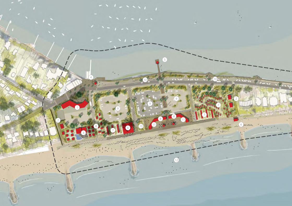
The architectural centrepiece of Sandbanks
Beach is the crescent pavilion which would
be developed with a glassy second storey
that would act as a modern extension of its
stripped and cool, civic classicism. The pavilion
would act as the focus for beach visitor facilities,
including a welcoming beach reception and
information, toilets, changing, etc. Within this
building a variety of beach huts, kiosks and
cafes would be provided. Amongst these
would be a select group of purpose-designed
7.1 Sandbanks Beach
A Dune Landscape
Boutique dune hotel
Sand dune
beach huts
Food and
drink pavilion
Beach retail /
food and drink / beach huts
Boat links
to harbourNew residential
Above: This view from the sea shows how groups of buildings could be set within a new dune landscape at Sandbanks Beach.

59
‘Beach Studios’ providing self-contained
accommodation, potentially for weekend and
overnight stays.
The look and feel of Sandbanks Beach will
be one generously dusted with sand in all
directions. Existing trees and dunes would
mix with new planting and reprovided dunes.
Within this soft landscape ecological habitats
would be encouraged as would public access.
Most areas would be accessible to all with
children encouraged to explore in safety. The
promenade would be retained but partly
modifi ed with timber boardwalks to create
a softer transition with the sand and beach.
Any loss of open space should be justifi ed and
replaced where appropriate.
New car parking areas would be disguised by
the framework of structural planting, whilst
additional car parking on Banks Road would
adopt an echelon format with frequent
landscape breaks.
Large-scale events at Sandbanks Beach will
continue, and use new open spaces and
car parks as currently. They would however
benefi t from signifi cantly improved technical
support, as well as more and better visitor
accommodation and facilities in a higher
quality setting.
7.0 Projects - A Framework for Change
Overnight
accommodation
Sand dune
beach huts
Sand dune
beach huts New residential Existing buildings
Sandbanks Beach Success Criteria:
Landscape, public realm and development
proposals must:
• contribute to the maintenance of Blue
Flag status.
• contribute to the creation of a coherent
landscape and public realm structure.
• contribute to the retention or creation of
ecological habitats.
• enable the provision of around 450 off
street parking spaces in total.
• Increase all year round activity, and
increase alternative and fl exible use of
car parking including additional on-street
parking in Banks Road.
• enable the provision of around 170 beach
huts or beach studios in total.
• include buildings no taller than 4 storeys
opposite 2-16 Banks Road and no taller
than 2 or 3 storeys elsewhere on the site.

Development Principles:
Landscape structure based around dunes
Two principal public spaces
Clear visitor focus around pavilion
Commercial / retail focus with passing
trade
Buildings to be 2/3 storey max; coherent
mini-complex of public /private facilities
Overnight beach studios
Better pedestrian routes from Beach to
Harbour
Lightweight pedestrian link to Shore
Road
Bus priority measures
Variable availability of car parks
Additional car parking in Banks Road
Pavilion converted for beach reception,
visitor facilities and accommodation
Commercial (eg. sports / clothing retail,
cafe/restaurant) with apartments above
(max 4 storeys)
Boutique hotel with seafront cafe/
restaurant
Beach studios, beach huts and cafe on
the sand
Beach houses (for lease)
1
C
BA
2
3
4
5
5
2
1
X
Y
Y
X
A
3
4
5
Once complete the master plan for
Sandbanks will reinstate a sand dune
landscape within which buildings, car
parking and outdoor activities are found.
A loose framework of dunes and open
spaces will provide the setting for public,
private and commercial buildings. Stands
of Scots Pine and a rolling dunescape will
subdivide the whole in to a series of cells,
creating a diverse set of spaces connected
by distinctive routes running between the
harbour and the promenade.
Above: Diagram highlighting the key development principles

61Middle left: (© mtr / Shutterstock.com)Bottom left: (© ariadna de raadt / Shutterstock.com)
Middle centre: (© holbox / Shutterstock.com)Bottom centre: (© Nikita G. Sidorov / Shutterstock.com)
Middle right: (© pics721 / Shutterstock.com)Bottom right: (© peresanz / Shutterstock.com)
Above: Image caption
2
2
6
3
1
4
613
11
12
11
7
7
7
8
88
9
9
10 10
9
5

63Above: Image caption
1. Commercial, food and drink, apartments
with private car parking and plazza
2. Beach houses
3. Sand dune hotel and dune
wedding venue
4. Water taxi business
5. Harbour arts cafe
6. Beach cafe / bar
7. Beach huts
8. Beach studio
9. Public car parking
10. Banks road parking on street
11. Beach facilities and beach offi ce
12. Swimming and viewing jetty
13. All ages play space
N
Illustrative Masterplan
Sandbanks Beach


65
7.2
Sh
ore
Ro
ad
The
Soci
al b
each

Development Principles:
Better entrance signage / space
Shared ped / vehicle approach
Multi-function public realm with
extended promenade
Buildings to be 2/3 storey max; coherent
mini-complex of public /private
facilities; designed to include landmark
element
Overnight beach studios
Lightweight pedestrian link to west over
dunes
Chines-meet-the-dunes landscape
character
On street car parking
Commercial retail/cafe/restaurant/bar
unit(s)
New day and overnight beach huts
Private apartments (for lease)
Harbour side coff ee / ice cream kiosk
1 2
3
4
1
2
3
4
The main structuring elements of routes
and destinations are largely in place at
Shore Beach. The principal challenges are
in replacing tired beachfront buildings
with a mini-complex around new public
space, and in leading the visitor to it via an
appropriate gateway landscape and shared
surface highway.
Above: Diagram highlighting the key development principles

67
The bustle and busyness of Shore Beach is a
product of its accessibility, its youthful crowd
and some of the uses that have clustered
here over recent years. The narrow funnel of
Shore Road contains views and activity in a
public realm which can be transformed to
become an elegant processional route to
the delights of the bay. At the mouth of this
road, and incorporating the existing public
gardens, a reorientation of the highway and
pedestrian routes should combine with a new
landscape scheme to create a fi tting gateway
to the beach. A shared surface street would
compensate for lack of width and would refl ect
the balance between pedestrians and vehicles
year round. Any opportunities for on street car
parking should be exclusively for the use of
Blue Badge holders whilst the majority of the
existing car park should be retained.
The frontage to the main car park, in common
with its neighbours, could be developed for
private apartments, providing useful revenue as
well as more natural surveillance.
On approaching the promenade a landmark
building and public space will be revealed,
marking the gateway to the promenade
and the transition between the chines and
the dunes along the beach. This most urban
location, overlooked by public and private
buildings, requires clearly defi ned public spaces
and should be addressed with suitably bold
contemporary architecture. A beach shop
would sit amongst two or three café bars and
kiosks serving sunworshippers, kitesurfers,
walkers, cyclists and others year round. The
landmark building would be the tallest and
might include a top fl oor café or restaurant to
make most of the superb views. A building of
four storeys could achieve 270 views, over the
top of the adjoining Sandbanks Hotel.
Moving north-east towards Branksome the
sloping land behind the promenade should be
redeveloped to combine a green dune frontage
and new beach huts and beach studios. High
quality accommodation of this type would be
attractive, especially to a younger customer
base interested in active sports. Any layout of
this area must better signal the footpaths back
towards Chaddesley Glen whilst incorporating
accessible gradients.
New development here should help maintain
the open aspect to the rear of properties in
Chaddesley Wood Road, but some additional
height will be acceptable where this enables
a better commercial operation and improves
placemaking, so long as each existing property
retains more than one oblique view to the sea.
7.2 Shore Road
The Social beach
7.0 Projects - A Framework for Change
Shore Road Success Criteria:
Landscape, public realm and
development proposals must increase
off peak use, and :
• contribute to the maintenance of Blue
Flag status.
• contribute to the creation of a
coherent landscape and public realm
structure.
• enable the provision of around 56
on and off street parking spaces (97
currently existing).
• enable increased on street parking in
Banks Road / Shore Road.
• enable the provision of replacement
beach huts plus around 80 additional
huts or beach studios..
• include buildings no taller than 3
storeys, including opposite Sandacres,
unless a 4 or 5 storey building at the
junction of the promenade and the
approach road incorporated a top
fl oor café or public function room.

15
23
16
17
1819
2022
21
14
Illustrative Masterplan
Shore Beach

697.0 Projects - A Framework for Change
N
14. Ice cream kiosk and coff ee hut
15. New apartments
16. Bike hire hut
17. Cafe / restaurant / bar, beach facilities
and visitor centre
18. Ice cream and sandwich shop
19. Cafe and shop units
20. Beach Facilities
21. Beach huts
22. Beach Studios
23. Re-confi gured car parking for apartments

Beach huts and studiosExisting buildings
Cafe / restaurant / bar, beach
facilities and visitor centre
Above: Shore Road has the most urban context and is the bustling westerly start of the promenade. As such it should be marked in a suitably bold and signifi cant way.

71Top left: (© Joe Ferrer / Shutterstock.com)Middle left: (© Xiaojiao Wang / Shutterstock.com)Bottom left: (© Ron Zmiri / Shutterstock.com)
Top centre: (© fotoadrenalina / Shutterstock.com)Middle centre: (© Filipe B. Varela / Shutterstock.com)Bottom centre: (© Berni / Shutterstock.com)
Top right: (© littleny / Shutterstock.com)Middle right: (© BL / Shutterstock.com)


73
7.3
Fla
gh
ead
Be
ach
Hu
t Li
fe

Development Principles:
Better entrance signage / wayfi nding
(inc. at beach)
Focal public space inc. public and retail
facilities
Infi ll beach huts and new kiosk
Small-scale improvements / additions
Minor improvements at Flaghead Beach would
include more beach huts and a new playspace
overlooked by a new ice cream kiosk.
Above: Diagram highlighting the key development principles

75
Notable mainly for the slender lane that hides
in the chine, Flaghead Beach stands halfway
between Shore Beach and Canford Cliff s yet
can be seen from neither. This privacy, or lack
of exposure, lends it a quiet calm and some
independence. any modifi cation here means
making modest alterations so as not to disrupt
this happy equilibrium.
By marking each end of the chine path with
a proportionate public realm scheme more
people will walk this useful route. At the foot
of the chine this traffi c will be attracted to
a relocated ice cream and snack kiosk, and
might want to spend time on the creative play
equipment which this overlooks.
Flaghead Beach is however principally
about spending time in and around ones
beach hut: Hut Life. This will continue and
any opportunities should be taken to make
a modest increase in the number of units
available here.
7.3 Flaghead Beach
Hut Life
7.0 Projects - A Framework for Change
Flaghead Beach Success Criteria:
Landscape, public realm and
development proposals must:
• contribute to the maintenance of
Blue Flag status.
• contribute to the creation of a
coherent landscape and public
realm structure.
• enable the provision of around 180
beach huts (including 24 new build).
• include buildings no taller than 2
storeys.
• Include woodland management and
biodiversity protection of SNCI.

Above: Halfway between Shore Road and Canford Cliff s Beach, Flaghead Beach is hidden from both lending it a quiet calm and degree of independence.

77
N
24. Ice cream kiosk and beach huts above
25. Beach huts
26. All ages play space
25 24
26
Illustrative Masterplan
Flaghead Beach


79
7.4
Can
ford
Cliff
s B
eac
h
The
Vill
age
Bea
ch

Development Principles:
Better entrance signage / wayfi nding
(inc. from shops)
More on street car parking
Focal public space
Walk route improvements
Reveal chine landscape especially at
promenade
All buildings to be 2 storey max
2nd level of promenade beach huts
with frequent gaps
Overnight beach studios (on the prom
or amongst trees)
Toilets / facilities at promenade level
Ecological / landscape management
plan
Lighting to promenade and chine
No net loss of public open space land
Extension / alteration of lifeguard
station to create cafe / kiosk building
Private house (for lease)
12
1
2
Clearer routes to the promenade, from
additional on street car parking, would
increase access to this beach and help
support better facilities and commercial
outlets. Adding a second fl oor above some
beach huts would increase the overall stock
whilst providing gap views through to the
cliff s behind.
Above: Diagram highlighting the key development principles

81
The route to the promenade beneath the
dense tree canopy of the chine conceals views
of the beach until the fi nal approach, which is
made between timber beach huts dating from
the Thirties. These huts, even more charming
as viewed from the promenade, epitomise the
small scale and intimacy of this beach, popular
with local families especially. Retaining and
further evolving this character (recognised in
its Conservation Area status) is essential to any
future change here.
Conserving and revealing the landscape
structure of the chine is also essential,
reinforcing the distinctive qualities of the
place and making it easier to read as a visitor.
By removing the concrete huts adjoining the
footpath of the north side of the chine the
sand and scrub planting of the cliff s can mark
its entrance and act as an appropriately soft
landmark.
Canford Cliff s Beach has numerous beach
huts, most in single storey blocks. Increasing
the number of beach huts by adding an extra
storey to some blocks, or part of a block, would
add usefully to the overall stock whilst creating
a more playful roofl ine and still conserving
views through to the green cliff s behind.
The quiet, family-focussed ambience here
makes it an ideal location for a few beach
studios where families, couples and small
groups could enjoy this special appeal. These
studios could be secluded amongst the trees
or overlook breaking waves fronting the
promenade.
The focus of Canford Cliff s Beach should remain
the former beach shelter, once converted and
extended, at the centre of a modest complex
of buildings designed to accommodate a café/
restaurant, kiosk and toilets. A small public
space here could include a proportionate
timber deck, extending over the sand to allow
for alfresco dining with a view, and mark the
chine on this otherwise straight stretch of
promenade.
This long stretch of beach has limited existing
car parking. Better signage to the beach from
Ravine Road would help as would additional
spaces on Cliff Drive and the Esplanade.
There is a potential small plot of land for the
development of a private dwelling adjoining
24 Cliff Drive. Exceptional architectural quality
would be required to ensure any building
added positively to the skyline.
7.4 Canford Cliff s Beach
The Village Beach
7.0 Projects - A Framework for Change
Canford Cliff s Beach Success Criteria:
Landscape, public realm and
development proposals must:
• contribute to the maintenance of Blue
Flag status.
• contribute to the creation of a
coherent landscape and public
realm structure including woodland
management.
• enable the provision of around 90 on
street parking spaces (70 existing) in
Esplanade and Cliff Drive.
• enable the provision of around 119
new build beach huts (194 existing).
• enable the introduction of additional
food and drink outlet/s serving the
beach.
• include buildings no taller than 2
storeys.
• Provide toilets at promenade level
• Improve access to the beach.

32
2829
27
29
31
33
33
35
Illustrative Masterplan
Canford Cliff s Beach

837.0 Projects - A Framework for Change
27. Cafe / restaurant
28. Ice cream / coff ee kiosk
29. Beach changing facilities
30. Beach sports changing facilities
31. Beach huts
32. Beach studios
33. Public car parking
34. Beach marquee’s and beach sports pitches
35. Private house - Cliff top N
3230
33
Above: By restoring and extending the art deco building at the foot of the chine as a centrepiece Canford Cliff s Beach can retain its period charm whilst providing updated facilities.
New beach huts over existing
Complex of buildings including café,
kiosk, toilets and changing space.

85Top left: (© ariadna de raadt / Shutterstock.com)Middle left: (© Karyna Che / Shutterstock.com)Bottom left: (© daseaford / Shutterstock.com)
Top centre: (© FIORENTINI MASSIMO / Shutterstock.com)Middle centre: (© Ye / Shutterstock.com)Bottom centre: (© sunsetman / Shutterstock.com)
Top right: (© 9comeback / Shutterstock.com)


87
7.5
Bra
nks
om
e B
eac
h
A W
ind
ow
on
th
e B
each
es

Development Principles:
Landscape connection from the chine to
the beach
Car parking at promenade retained
within public realm
Multi-function public realm, with
potential for events
Better pedestrian routes from Beach
Road / Western Road
Reordered and better managed Beach
Road car park (inc off season ‘car
parking’)
More on street car parking
Buildings to be 2/3 storey max;
harmonious with central cafe/restaurant;
to include public sundecks; to respect
and reinforce alignment of chine
Water sports facilitated with better
promenade access, support facilities,
storage space
Overnight beach studios
Potential redevelopment or regeneration
of shop/ toilets building for cafe/shops/
toilets/changing/fi rst aid/ management/
storage
Potential new water sports building with
shop/teaching space/stores/changing
Cliff edge ‘sky cafe’ adjoining Western
Road car park
1
2
3
1
2
3
Branksome Beach is the most accessible
location along the seafront. By making it
easier to use car parks at Western Road
and Beach Road, and adding on street
car parking, a more multifunctional
public space is possible adjacent to the
promenade. By adding more active uses
around this space, involving watersports,
retail and food-and-drink, it can act as a
primary gateway to the sand, the sea and
the views.
Above: Diagram highlighting the key development principles

89
The breadth of the chine and sheer accessibility
at Branksome Beach lend this location
an unequalled prominence and strategic
signifi cance. Wider and longer than its siblings
to the south, Branksome Chine opens wide at
its mouth yet is well-defi ned by steep ridges
creating a satisfying framed view between land
and sea. Now contained by the promenade
the primacy of this natural and public link to
the water should be refl ected in any landscape
or public realm proposals here. Biodiversity
interests will be respected in the SNCI
designation along the back of the promenade.
Pinecliff Road will continue to make an
important connection but should glide
discretely through a cohesive public space. This
space should be pedestrian-dominated but will
accommodate most of the existing car parking
albeit aligned so as to allow for easier, safer and
more direct routes to the beach.
Within a Conservation Area and sitting on
the edge of the promenade is the popular
Branksome Beach café/restaurant within the art
deco former beach station (which is a locally
listed building). The quality of the food and
drink off er here should be extended by the
addition of one or two more outlets, as well
as shops and a kiosk. This building should be
refurbished and extended as required whilst
retaining the key features of interest.
On the southern fl ank of this space an awkward
element of the car park could be developed
with a multi-functional building aimed at the
watersports and visitor communities. A small
shop for watersports equipment could benefi t
from passing trade as well as serving the beach
community in general. Storage space for small
craft and changing facilities for users could
combine with training and teaching areas, as
currently exists for the Branksome Chine Surf
Life Saving Club. It is possible that it could be
managed by a commercial operator.
The height of the cliff and spread of vegetation
combine with the almost imperceptible curve
of the cliff s to present a singular opportunity for
panoramic views from a new café/restaurant
projecting from Western Road car park. Subject
to a full technical and fi nancial assessment,
this new Sky Café could become a truly iconic
addition to The Seafront Beaches of Poole.
Whether a destination restaurant or a family
café, an elegant architectural and engineering
solution would be required that accentuates
the landscape setting and refl ects the tension
of the structural feat achieved.
Elsewhere along the beach, redevelopment
and rationalisation can increase the overall
number of beach huts, move toilets to
promenade level and relocate kiosks.
7.5 Branksome Beach
A Window on the Beaches
7.0 Projects - A Framework for Change
Branksome Beach Success Criteria:
Landscape, public realm and development proposals must:
• contribute to the maintenance of Blue Flag status.
• contribute to the creation of a coherent landscape and public
realm structure, plus woodland management.
• contribute to the retention or creation of ecological habitats.
• enable the retention of, and greater use of, around 420 off
street parking spaces at Beach Road and Western Road.
• enable the reduction of car parking to around 70 spaces
adjoining the promenade.
• enable increased on street parking in Pinecliff Road and Beach
Road.
• enable the provision of around 120 new build beach huts
(including 254 existing).
• enable the introduction of additional food and drink and retail
outlets serving the beach and Pinecliff Road.
• enable the creation of a commercial/retail/watersports hub
between Pinecliff Road and the beach.
• include buildings be no taller than 3 storeys.

3939
36
Illustrative Masterplan
Branksome Beach

91
36. Sky cafe
37. Ice cream kiosk / cafe
38. Public toilets
39. Beach huts
40. Public car parking
41. Beach facilities
42. Cafe / restaurant, shop units
and visitor centre
43. Water sports building
N
39
42
40
40
39
3738
40
40
41
43

Above: New and refurbished buildings overlooking the beach and chine may well respond to the opportunities at Branksome Beach for more activities year round as well as in the peak season.
Existing building Public space with car parking
Cafe / restaurant, shop units and
visitor centre within developed and
extended existing building

93Top left: (© VetrovaMaria / Shutterstock.com)Middle left: (© DWaschnig / Shutterstock.com)Bottom left: (© FIORENTINI MASSIMO / Shutterstock.com)
Top centre: (© Dima Fadeev / Shutterstock.com)Middle centre: (© ep_stock / Shutterstock.com)Bottom centre: (© J.A.Astor / Shutterstock.com)
Top centre: (© Worldpics / Shutterstock.com)Middle centre: (© Poprotskiy Alexey / Shutterstock.com)Bottom centre: (© Gunnar Assmy / Shutterstock.com)

Development Principles:
Better entrance signage / space
Focal public space
Vehicle access improved by local
widening
Greatly enhanced pedestrian routes,
seperate from road
Ecological / landscape management
plan
Reveal chine landscape especially at
promenade
Buildings to be 2/3 storey max; multi-
volume (rather than monolithic);
designed to follow contours; recessive
in scale and materials
Water sports facilitated with better
promenade access, support facilities,
storage space
Maximum car parking retained (inc off
season ‘car parking’)
Overnight beach studios
No net loss of public open space land
Ground and rope walks amongst trees
Either Hotel with function space (40
beds max) or Remade Community
Building (plus small-scale
accommodation).
1
Above: Diagram highlighting the key development principles
As elsewhere along the seafront beaches,
revealing, restoring and celebrating
the landscape is the key to change at
Branksome Dene Beach. Whilst modest
improvements can be made to access, both
by car and on foot, this location will always
be most memorable as a deep, green bowl
behind a popular beach a short walk from
Bournemouth.
1

95
7.6
Bra
nks
om
e D
en
e B
eac
h
Wo
od
lan
d-b
y-th
e-S
ea

Above: Change at Branksome Dene Chine should include decluttering the landscape to reveal the chine and create platforms for new buildings and facilities.
New beach toilets / facilities
and kiosk at promenade level
New community and wedding
venue (or site for a small hotel) Tree top adventures
Landscape revealed at
mouth of chine

97
Improving direction signs and the narrow
access road are key to increasing the use of
this popular beach. An enclosed, sylvan bowl
this most easterly chine formally welcomes
visitors to the start of Poole’s beaches. However,
woodland management and SCNI protection
must be at the core of any future proposals.
Dominated by gorgeous green cliff s and fi ne
soft sand, and comprising watersports, cream
teas on the terrace and wholesome families
playing in the sea – welcome to Dorset-on-Sea.
Change here could include a new and larger
Community and leisure venue in an elevated
position with an enlarged terrace and a handful
of rooms for hire. Other parts of this small
focal group of buildings would include new
changing space, toilets and showers. A kiosk
could be located on a deck that projects over
the sand in a similar style to the decks at Shore
Beach and Canford Cliff s.
The large, untamed woodland of the chine
could be accessed via a new rope adventure
activity feature. Whilst winter and wild day
watersports should be supported here with
improved facilities and access. Overnight
accommodation attractive to this community,
as well as others, should be provided in limited
numbers. The majority of existing beach huts
here should be retained.
The intimate scale, sense of enclosure and
discrete approach might make this location
particularly appealing as a venue for managed
music or performance events, perhaps
designed in conjunction with adjoining
residents.
Should an operator of suffi cient calibre be
found then an hotel could be located here
in place of the community/wedding space.
(If it were that function would be relocated
elsewhere along the seafront beaches). The
design of this building would have to be of
the highest quality whilst its mass and height
should be subservient to the landscape setting,
comprising the cliff s, promenade and beach.
7.6 Branksome Dene Beach
Woodland-by-the-Sea
7.0 Projects - A Framework for Change
Branksome Dene Beach Success Criteria:
Landscape, public realm and
development proposals must:
. Increase use all year round.
• contribute to the creation of a
coherent landscape and public realm
structure.
• contribute to the retention or creation
of ecological habitats plus woodland
management.
• enable the retention of around 130 off
street parking spaces.
• enable the provision of around 8
new build and 79 existing beach huts
and 5 new beach studios in total
(including replacement and new).
• enable the introduction of additional
food and drink outlets serving the
beach.
• include buildings be no taller than
2 storeys (or 3 storeys in the case of
hotel of exceptional architectural
quality).

44. Beach Facilities
45. Ice Cream Kiosk
46. Beach Huts
47. Community and events space with
accommodation (or site for a small hotel)
48. Public parking
49. Beach studios
50. Tree top walk way and nature experience
N
45
44
46
46
48
50
50
474949
Illustrative Masterplan
Branksome Dene Beach

99Top left: (© Berni / Shutterstock.com)Middle left: (© Dima Fadeev / Shutterstock.com)Bottom left: (© photobank.ch / Shutterstock.com)
Top centre: (© Nikita G. Sidorov / Shutterstock.com)Middle centre: (© Todd Kuhns / Shutterstock.com)Bottom centre: (© ASchindl / Shutterstock.com)
Top centre: (© Lex-art / Shutterstock.com)Middle centre: (© James Clarke / Shutterstock.com)Bottom centre: (© Harm Kruyshaar / Shutterstock.com)


101
8.0
De
live
rin
g t
he
Mas
ter
Pla
n
9.0
Co
ncl
usi
on

The Council and key stakeholders will continue
to work together in partnership to deliver the
full potential of The Seafront Beaches of Poole.
Important factors to consider include:
• focussing on a clear delivery strategy which
maintains momentum and a strategic
overview.
• planning for short, medium and long term
success, including implementing high value
sites throughout the project.
• recognising the importance of the overall
vision and building a reputation for quality.
• retaining the ability to respond to strong
opportunities whislt remaining true to key
principles and the overall vision.
• ensuring infrastructure investment and
public realm projects, including landscape
management and habitat creation, are
delivered at the same rate as commercial
developments. And,
• producing a fi rst phase which is suffi cently
broad and comprehensive that it can be
used to demonstrate several key features of
the master plan, for instance including a mix
of land uses, new public realm, infrastructure
investment and good quality design
including high grade materials.
Development guidance
Development Briefs
It may be desirable or necessary to produce
a Development Brief for one or more of the
master plan locations. The largest, Sandbanks
Beach, would seem the most obvious
candidate. Such a document would add
further detail to the form and nature of change
anticipated and would be consulted on prior to
adoption. As well as more fully illustrating what
is envisaged a Development Brief would also
be valuable in reducing risk for the landowner
and investor.
Public Realm Design Guide
The performance requirements and physical
appearance of the Public Realm is critical to
the success of the Master Plan but can only
be covered in strategic terms in a document
such as this. It is recommended that a specifi c
companion guide to the Master Plan be
produced and that regard is paid to the SPD
‘Our Streets and Spaces’ .
8.0 Delivering the Master Plan

1038.0 Delivering the Master Plan
The Seafront Beaches Master Plan provides:
• a fl exible framework for the future.
• a strategic town planning context.
• an overall structure for understanding and
developing the beaches.
• a series of implementable projects over the
short to long term, at all scales and catering
to diff erent markets.
It responds to the 3 aims set out earlier:
1. Conserve the beautiful natural
environment.
2. Improve the range of facilities to
encourage vistiors all year round.
3. Invest in the ageing infrastructure such
as drainage and toilets, to ensure the
preservation of core services.
This document represents the input and
creativity of a substantial number of people
including the residents of Poole, their
Councillors, their Council offi cers, local and
regional stakeholders, and the Consultant
team led by LHC. The SPD is a Planning
document designed to explain the Master
Plan for the seafront beaches in broad terms
rather than detail. Further work is required
on various matters including a fi rst phase of
change. The importance of the latter cannot be
underestimated.
Doing Nothing to the seafront beaches is not
an option. Years of underinvestment have
created a substantial backlog of infrastructure
work for which no public money has been,
or is likely to be, allocated. Doing Something
allows the community to take positive steps to
maintain the quality and appeal of the beaches
for future generations. Doing Anything is risky
in terms of the sensitivity of the environment
and potential for objections from within the
community. Whatever detailed proposals do
come forward must therefore be carefully
considered, cleverly designed and clearly
communicated.
Poole’s beaches are breath-taking, precious,
fragile and much-loved - and they must and
can remain so. Updating and adding to the
facilities available along them, and creating
a self-sustaining beach environment, can be
done in this context. As we say above, nothing
should detract from the simple pleasures to be
had in such a spectacular setting.
9.0 Conclusion


105
10
.0 R
efe
ren
ce M
ate
rial
11
.0 I
mag
e C
red
its

10.0 Reference Material
a. Seafront Beaches Strategy (2011)
b. Strategic Flood Risk Assessment Level 1
(2009)
c. Flood Risk MAanagement Strategy (2011)
d. Poole and Christchurch Bays Shoreline
Management Plan Review Sub-cell 5f -
Section 4. Policy Development Zone 3
(2011)
e. Beach Master Plan Planning Assessment
(2011)
f. Beach Road Conservation Area designation
leafl et (1990)
g. Canford Cliff s Conservation Area
designation leafl et (1989)
h. Sandbanks Conservation Area Appraisal
and Management Plan (2009)
i. Shoreline Character Areas SPG (2004)
j. Borough of Poole Characterisation Study
(2010)
k. Poole Core Strategy (2009)
l. Poole Site Specifi c Allocations and
Development Management
Policies Development Plan Document
(2011)
m. Poole Beach Survey 2002
n. Poole Opinion Panel Survey Spring 2009
o. Poole Opinion Panel Survey Spring 2010
p. Poole Tourism Strategy 2006-2015
q. Leisure Strategy for Poole – Consultation
Draft 2011-2015
r. Beach Master Plan Public Engagement
Report?
s. Bournemouth Seafront Strategy 2007-2011
(2006)

107
11.0 Acronyms
BoP Borough of Poole Council
DPD Development Plan Document
LDF Local Development Framework
LHC Lacey Hickie Caley consultants
SBMP Seafront Beaches Master Plan
SMP Shoreline Management Plan
SNCI Site of Nature Conservation Interest
SPD Supplementary Planning
Document
SSADMP Site Specifi c Allocations &
Development Management Policies
DPD
SSSI Site of Special Scientifi c Interest
11.0 Image Credits

The project team is as follows:
LHC - Urban Design, Architecture & Landscape
Layout, design and master planning
Goadsby - Commercial Agents
Commercial strategy, property market advice
PH Warr - Quantity Surveyors
Development appraisal, costs and funding
Buro Happold - Engineering
Environmental Sustainability and Transportation
Bournemouth University - Future Tourism
Future tourism, Visitor attractions, Global trends
Unless otherwise stated, the Ordnance Survey
mapping included within this document is
provided under licence from the Ordnance
Survey. Persons viewing this mapping should
contact Ordnance Survey copyright for advice
where they wish to licence Ordnance Survey
mapping/map data for their own use.
Unless otherwise stated, copyright for
photographic and other illustrative material is
owned by Lacey Hickie Caley Ltd (LHC).
This publication has been produced to
support the Full and Listed Buildings planning
application and should not be used for
any purpose other than that intended. Any
reproduction of this publication or of any
pictures /drawings in whole or in part without
Lacey Hickie Caley Ltd (LHC) express written
permission is prohibited.
All rights reserved Lacey Hickie Caley Ltd (LHC).
© LHC 2012.

in association with
BOROUGH OF POOLE