Embed Size (px)
Citation preview
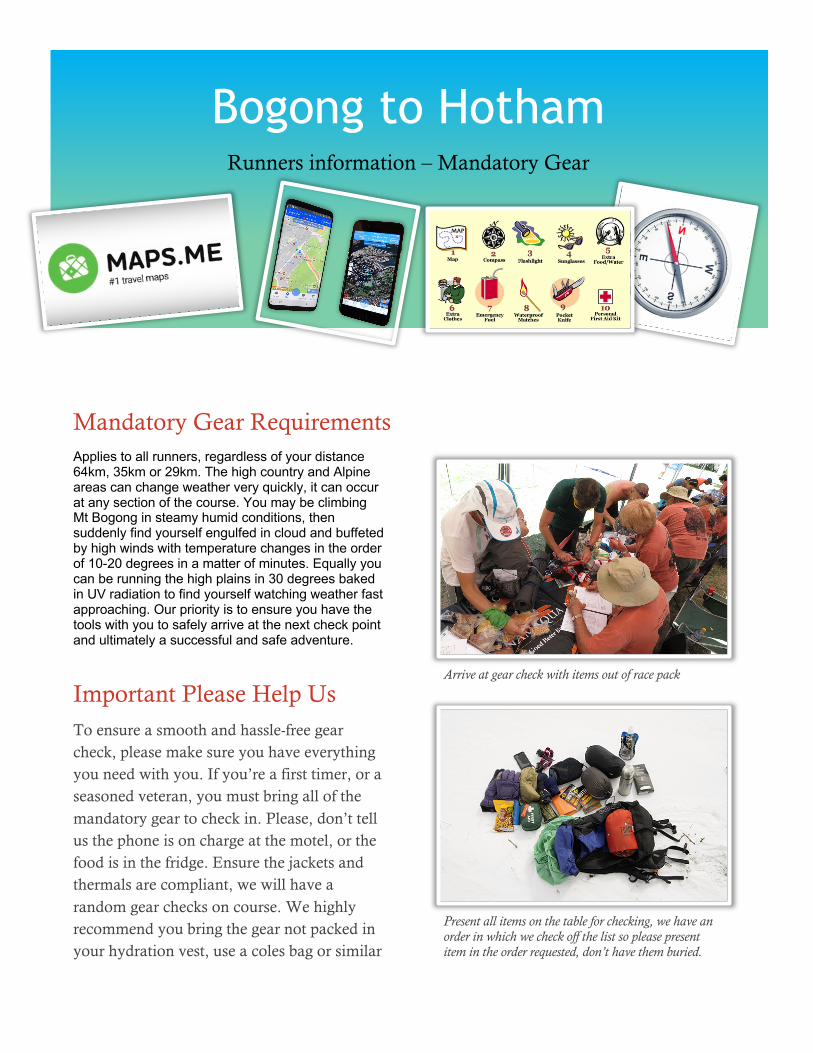
Mandatory Gear Requirements Applies to all runners, regardless of your distance 64km, 35km or 29km. The high country and Alpine areas can change weather very quickly, it can occur at any section of the course. You may be climbing Mt Bogong in steamy humid conditions, then suddenly find yourself engulfed in cloud and buffeted by high winds with temperature changes in the order of 10-20 degrees in a matter of minutes. Equally you can be running the high plains in 30 degrees baked in UV radiation to find yourself watching weather fast approaching. Our priority is to ensure you have the tools with you to safely arrive at the next check point and ultimately a successful and safe adventure.
Important Please Help Us To ensure a smooth and hassle-free gear check, please make sure you have everything you need with you. If you’re a first timer, or a seasoned veteran, you must bring all of the mandatory gear to check in. Please, don’t tell us the phone is on charge at the motel, or the food is in the fridge. Ensure the jackets and thermals are compliant, we will have a random gear checks on course. We highly recommend you bring the gear not packed in your hydration vest, use a coles bag or similar
Arrive at gear check with items out of race pack
Present all items on the table for checking, we have an order in which we check off the list so please present item in the order requested, don’t have them buried.
Bogong to Hotham Runners information – Mandatory Gear

Light Kit The following equipment must be carried if the weather is considered fine and low chance of extreme cold
conditions, however we do recommend you carry the full kit regardless of forecasted conditions:
• Waterproof jacket with hood ( we will most likely ask you to unpack it to show us in full, it MUST FIT YOU correctly
(must be waterproof and not just water resistant. ie Gortex, or similar, must have sealed or taped seams) • Long sleeve thermal top, polypro or merino (compression top not adequate; technical running top not adequate; if you
don't know what constitutes thermal find out; no short-sleeves with arm warmers) • Map and course diagrams in a waterproof bag (can be zip-lock): Spatial Vision's Bogong Alpine Area Outdoor Recreation
Guide 1:50,000 Scale available at all good map shops. An alternative map is now available and comes made from waterproof plasticised paper from Rooftop maps Bright - Dartmouth Adventure Map. This map has a great detailed version of the course. The line diagrams can be downloaded from "Course Description-Diagrams" in the sidebar. You need a copy of the course notes with you.
• Compass-NOT an electronic one such as on an iphone, Garmin or other GPS. Must be manual with swinging needle that can be read easily
• Whistle (can be in pack strap)
• Compression Bandage (for snake bite) must be compression (heavy weight crepe) and not just loose crepe bandage.
MUST BE 10cm WIDE minimum and look like this. • Space blanket or bag • 1000 kilojoules of emergency food (in addition to any food expected to be consumed during the run) • Capacity to carry at least 1 litre of water (i.e. bladder or bottles) • Mobile phone (telstra 4/5 G has best cover age and is recommended) • NEW ADDITION (MAPS.ME app) with loaded course ( see APPS.ME notes and instructions late in document). • If previously have avenza we prefer you to update to MAPS.ME
Full Kit The following equipment must be carried if weather is bad, but not so bad that the event is
cancelled (this will be determined at the race briefing on the Saturday afternoon before the
race so be sure to still bring it with you):
All items in the light kit plus the following: • Waterproof over pants • Thermal long johns (compression tights do not count, must be polypropolene, merino or
similar) • Warm beanie or buff • Gloves (can be lightweight running gloves) • Extra 3000 kilojoules emergency food (imagine being stuck overnight in a hut with no
food) • Cigarette lighter or waterproof matches (for use in huts if needed) • (PLB - totally optional and for absolute emergency use only)
IF YOU HAVE ANY DOUBTS ABOUT YOUR GEAR THERE IS A GOOD CHANCE IT WON'T
PASS THE CHECK. WITHOUT THE APPROPRIATE GEAR YOU CANNOT START THE
RACE. BRING SPARES, OR CHECK BEFORE LEAVING FOR THE RACE. LIMITED
SUPPLIES AVAILABLE AT MT BEAUTY ONLY.
Random Gear Item Check We will be conducting RANDOM gear checks, most likely at BOGONG HIGH PLAINS ROAD
CROSSING, this will involve you the runner selecting an item from the full list out of a
container, then showing us the item before proceeding.

SUMMARY ITEMS TO TICK, please use as your guide This is the order in which we will be carrying out the gear check, it helps if you present them in order. If it’s not checked off this self check list, don’t present at gear check as you will be rejected and cant start. LIGHT KIT in the event of favorable long-term forecast 1 Fully Charged Mobile Phone 2 Spare Battery & Lead to charge phone, not previously required 3 MAPS.ME loaded B2H course, replaces avenza as option if don’t have 4 PAPER MAP & Diagrams, refer below and print. 5 MAP cover, Zip Lock Bag is ok 6 COMPASS 7 WHISTLE, can be as attached to vest 8 JACKET, hooded sealed seam, no excuses 9 THERMAL top 10 10CM Compression Snake Bandage 11 SPACE blanket 12 WATER 1ltr minimum, recommend 1.5 13 FOOD, emergency use 1000kj HEAVY KIT in the event forecast conditions require 14 OVERPANTS water proof 15 THERMAL bottoms 16 BEANIE or BUFF 17 GLOVES full fingered 18 MATCHES or Lighter 19 FOOD extra 3000kj
Bogong to Hotham 2019 Runners information - update
Bogong to Hotham 2019 Runners information - update

MAPS.ME INSTRUCTIONS A link to the MAPS.ME gps/gpx and KML file will be forward to online entrants prior to Jan 1st. Instructions for loading file can be accessed via the link provided as well as the detailed description below. NOTE loading GPS files is done as a BOOKMARK.
How to import bookmarks? You can import bookmarks sent from MAPS.ME or third party apps or email if they were sent in KML format: We have provided both GPS/GPX files and KML files of the full 64km course, Use the KML file for MAPS.ME 1. Open shared KML/KMZ file with bookmarks sent by email
iOS
Tap the file with bookmarks (KML or KMZ format) → tap Share button in the upper right corner → choose Import with maps.me in the pop-up window.
Android
Tap the file with bookmarks (KML file) → choose Open with MAPS.ME in the pop-up window (if you have no other apps that support KML files, the file will be instantly open in MAPS.ME).
LINKS for more information MAPS.ME BOOKMARK LINK OUR PREFERENCE IS NOW FOR YOU TO USE MAPS.ME and NOT AVENZA, but if you already have AVENZA from previous years this will be accepted for 2019. PRINTABLE MAPS ARE HERE
Above is IOS screenshots to load bookmarks
Above is Android screenshots to load bookmarks