Embed Size (px)
Citation preview
Rock glaciers, protalus ramparts and related phenomena, Rondane, Norway: a continuum of large- scale talus-derived landforms RICHARD A. SHAKESBY, ALASTAIR G. DAWSON AND JOHN A. MATTHEWS
Shakesby, Richard A , , Dawson, Alastair G. & Matthews. John A. 1987 09 01: Rock glaciers. protalus ramparts and related phenomena, Rondane, Norway: a continuum of large-scale talus-dcrivcd landforms. Boreas. Vol. 16, pp. 305-317. Oslo. ISSN0300-9483.
Talus-derived landforms from Rondanc National Park, southern Norway, arc described and classified a s protalus ramparts, valley-floor and valley-side talus-foot rock glaciers. and a ‘push-deformation’ mor;uiic A morphological and developmental continuum of talus and derivative large-scale landforms is proposed. with simple talus slopes at one end and more complex ridge, lobe and hcnch forms at the other. The various types of feature probably develop from simple talus slopes via separate dcvclopmentel route$, rather than as a linear sequence. Lichen size and Schmidt hammer R-values were used to indicatc thc relative ages of the features. Although all are thought to have originated during the early Holocene. thcy differ in the presence or extent of recent activity. Hence an age and activity continuum is also suggested. the recency of activity increasing in the direction protalus rampart + rock glacier + ‘push-deformation’ morainc.
Richard A . Shakesby. Department of Geography, Unioersity College of Swunseu. Singleton Purk. Swunsrci SA2 8PP, U . K.; Alastair G . Duwson, Departmentof Geography. Lanchester (Coventry) Po/vlechnic, Priory Street, Cooeiitry CVl 5FB, U . K.; John A . Matthews, Sub-Department of Geogruphy. Lkpartrnent of Geology. Uniuersity College Cardiff, P . O . Box 78, Cardiff CFI I X L , U. K . ; 27th January, 1987.
B O B
During the last two decades, interest in rock glaciers, protalus ramparts and related landforms has increased markedly, but our understanding remains limited. Rock glaciers in particular have attracted increased attention but disagreement continues about their definition and classification (cf. 0strem 1971; Johnson 1973; Barsch 1971, 1977; Whalley 1979) and about their origin and sensitivity to environmental change (e.g. Swett et al. 1980; Humlum 1982; Giardino 1983). For the purposes of this study talus-foot or lobate rock gla- ciers are defined as being broader than they are long and composed of deformed talus developed along valley walls below cliffs. Various theories have been proposed to explain their movement down valley sides and onto valley floors, including creep of an ice core or of interstitial ice, or basal shearing which may be aided by hydrostatic pres- sure or by pore water trapped beneath a frozen veneer (Giardino 1983; Giardino & Vick 1985). A range of indicators of activity and inactivity of rock glaciers has been proposed. Indicators of activity have included the presence of an ice core (CortC 1976), the considerable thickness of a feature, the presence of steep boundary slopes with sharp breaks of slope, the existence of fine material or the
lack of vegetation on the front slope (Wahrhaftig & Cox 1959; Barsch 1977), and fresh breaks in the surface (Foster & Holmes 1965). Supposed indi- cators of inactivity have ranged from low-angle boundary slopes, presence of collapse structures (Barsch & Treter 1976; Sissons 1976), large lichens (Luckman & Crockett 1978), continuity of lichen cover (Wahrhaftig & Cox 1959) to a well-estab- lished soil and vegetation cover (Barsch & Treter 1976).
Protalus ramparts also present problems of definition and origin. They are generally assumed to form by debris sliding over the snow and accumulating at the foot of a perennial snowbank (Richmond 1962), but this remains unsubstanti- ated by field observation (Johnson 1983) and simi- larities or connections have been proposed in the development of protalus ramparts and rock gla- ciers (Grotzbach 1965; CortC 1976; Sissons 1976; Ballantyne & Kirkbride 1987).
With a few exceptions (e.g. Griffey & Whalley 1979; Matthews & Petch 1982; Lindner & Marks 1985; Vere & Matthews 1985), little is known about rock glaciers and related forms in Scandinavia. This was emphasized by the debate on ice-cored moraines between astrem (1971) and Barsch

306 Richurd A . Shmkesby ef UI BOKEAS 16 (1987)
11971). i n Rondane, StrOm (1945) described 'debris ledges' formed in a similar manner to that assumed for protalus ramparts while Barsch & Tre- ter (1976) used mainlv aerial photographs to iden- tify fourteen rock glaciers. We present here the results of a more detailed investigation carried out in Rondane of five landforms identified as active rock glaciers and one as inactive according to these authors. together with an additional three land- forms. Emphasis is given to the morphology. age and activity of these features with special ref- erence to their classification, development and interrelationships.
Background The central massif o f Rondane National Park is a mountain range of some 200 km- with a number of peaks exceeding 2.000m and a highest point of 2.178 m (Rondslottet) (Fig. 1). The mean annual temperature is(. -5°C at 1.500 m and mean annual precipitation amounts to about 460 mm (Dahl 1956). Glacier ice is absent except for a possible residual patch in Smedbotn. According to Sollid s( Reite (1983:50). the last ice sheet covered Ron- ciane up to c. I .XU0 m in the Preboreal Chrono- Lone. At that time local cirque glaciers occupying the higher i,allrys converged with the main ice
sheet, giving rise on deglaciation to extensive fluvioglacial deposits in the valley bottoms ofDor%- len and its tributaries.
The area comprises mainly an arkosic sandstone known as sparagmite. The combination of steep vallev sides. well-jointed rock. freeze-thaw con- ditions and low stream activity in the upper valleys has led to talus-covered lower slopes and block- field-covered floors. The features on which this study focuses are located in the valleys of Lang- holet, Smedbotn and Bergedalen at altitudes of c. [email protected] m (Fig. 1).
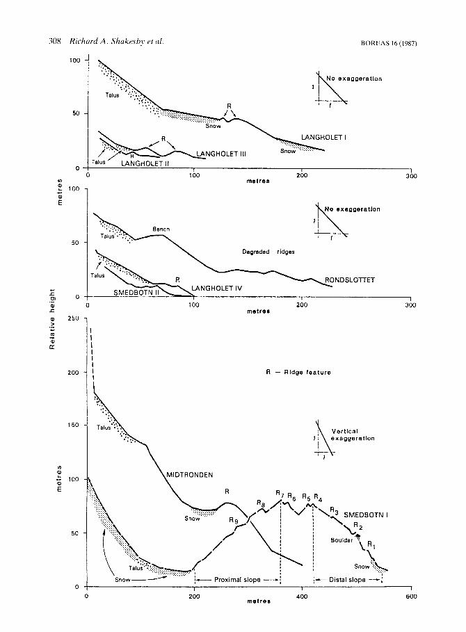
Morphology Selected long profiles for the features were deter- mined using an Abney level and 30 ni tape. Read- ings were recorded to marked breaks of slope or to 30 111 ground lengths (Fig. 2). All features are characterized by angular blocks up to about 6 m in size. Morphological details of each feature are given in Table I ,
Lairgltolr,f. -Four landforms along the W slope of Langholet valley were studied (Fig. 1; Table 1). Langholet I has a crtnulate plan form partly obscured by snow when measured. Langholet 11, I11 and IV have not been previously referred to in
A ROCK glocierorreioted landform Londrltde Loke 8 r l v e i
big. 1. Location of talus-dcrivcd landtotin5 in Rondane. central southern Norway.

Tabl
e 1
. Cha
ract
eris
tics
and
clas
sific
atio
ii of
tal
us-d
eriv
ed la
ndfo
rms,
Ron
danc
.
Feat
ure
Asp
ect
Max
. A
ltitu
de
leng
th
(m)
(n1)
Lan
ghol
et I
Lan
ghol
ct 11
L
angh
olet
111
L
angh
olet
1V
Sm
edbo
tn I
Smed
botn
I1
Ron
dslo
ttet
Mid
tron
dcn
Vcr
kils
dalc
n
EN
E
E E
NE
N
W
N
SW
NW
1,58
0 23
0
I .52
(J
6 1,
480
56
1,48
0 23
1,
600
350
1.58
0 18
0
1,52
0 23
0
1,54
0 19
0
1.30
(1
1,60
0
Max
. B
read
th
talu
s sl
opt
(m)
angl
e (“)
550
31
280
35
590
34
305
31
580
34
420
33
750
34
i,m
38
750
~
Dis
tal s
lope
Ove
rall
angl
e M
ax. a
ngle
M
orph
olog
ical
(“1
(“1
ch
arac
teri
stic
s C
I a s s
i fi c a
t ion
29
33
25
31
25
41
31
34
-
36
34
35
31
41
54
50
43
-
2 rid
ges
1 rid
ge
2 rid
ges
1 rid
ge
Mul
tiple
ridg
es
Ben
ch +
su
rfac
e ri
dges
B
ench
+ lo
bes
Ben
ch, l
obes
+ s
urfa
ce ri
dges
L
ohat
e ri
dge
com
plex
Tal
us-f
oot
rock
gla
cier
Pi
otal
us r
ampa
rt
Prot
alus
ram
part
Pr
otal
us ra
mpa
rt
Push
-def
orm
atio
n m
orai
ne
Tal
us-f
oot
rock
gla
cier
T
alus
-foo
t ro
ck g
laci
er
Tal
us-f
oot
rock
gla
cier
L
ands
lide
Not
e: A
ltitu
de =
aiti
tudc
of
toe.
M
axim
um le
ngth
= n
iax.
leng
th tr
om t
he ta
lus
foot
mca
surc
d to
the
oute
r rid
ge/b
ench
crc
st.
Full
deta
ils o
n th
e V
erki
lada
len
feat
ure
are
give
n in
Daw
aon ef
a[. 1
986.
BOREAS 16 (1987) 308 Richard A. Shukesby et al.
100
50
0
In : 100 +.a
al E
50
0
250
200
150
v)
: - 100
E
50
0
........ ................. ....... .................. * ....................... :.:.: .:_: ....... ..... 1 .
No exaggeratlon
lk
-LET .:_ . ....... I ........... Snow ..... :.:.: ....
I Talus ’ LANGHOLET I1
0 100 200 300 I I I I
metres
1
Degraded ridges
0 100 200 300 metre8
R - Ridge feature
Ver t lca l exaggeration
I-- Distal slope ---; I 1 I
0 200 400 600 m e t r e s

BOREAS 16 (1987) Talus-derived landforms 309
Table2. Lichen size data for the talus-derived landforms in Ron- dane. Result,aregivenforthediameter(mm) ofthesinglelargest (1.1) and the mean diameter of the five largest (5.1) lichens in 250 m2 search areas
Location
Smedboin I Outside Ridge 1 Ridge 2 Ridge 5 Ridge 6 Ridge 7 Ridge 8 Ridge 9 Proximal slope
Proximal slope
Smedbotn I1 Outside Outer ridge Inner ridge
Langholet I Outside Outcr ridge Inner ridge Talus foot
Langholer 11 Outside Ridge Talus foot
Langholet 111 Outsiae Outcr ridge Inner ridge Talus foot
Langholer IV Outyidc Ridge Talus foot
Midtronden Outside Outer ridge Inner ridge Talus foot
Rondrlottei Outside Degraded ridge bench Talus foot
(top)
1.1 5.1
270 25 1 235 206 225 212 260 222 235 220 180 158 115 100 95 95
93 79 65 55
265 232 370 280 325 274
285 216 250 226 220 181 120 69
280 241 235 217 190 174
288 239 220 205 285 264 155 I37
250 227 240 213 145 133
355 298 400 329 445 254 115 98
245 237 310 248 240 224 220 187
the literature. They consist of well-defined single or double ridges (Fig. 3).
Smedbotn. - Two landforms were investigated in Smedbotn (Fig. 1). Smedbotn Iforms alarge, high, arcuate, multiple-ridged structure enclosing a deep hollow near the valley headwall (Fig. SC). Proximal slope angles range from 8" to 48" with an overallangleof24". SmedbotnII, locatedc. 0.5 km downvalley from Smedbotn I (Fig. l ) , comprises a broad, undulating bench at its Send from where it narrows northwards to form two ridges (Fig. 2 ) .
Bergedaien. - Two Iandforms were analysed in Bergedalen (Fig. 1). The Rondslottet feature is an arcuate bench, ridge and lobe complex below the N-facing spur of Rondslottet peak (Fig. 4). At its S end, it forms a narrow bench emanating from an area of two small, ill-defined lobes (Fig. 2 ) . Below the bench, the valley floor comprises up to three low, ill-defined ridges (<3 m high) paralleling the bench. Farther N and E, as the bench curves around the talus slope, it descends and gives way to two-steep-fronted talus lobes (Fig. 4A). On the opposite valley side lies the Midtronden feature. It forms an apron below a broad bedrock spur (Fig. 5B). It consists of an outer broad ridge, four lobes and several short. bench-like features.
Verkilsdalen. - A large feature occupies the entire NW-facing, wedge-shaped spur end slope of Sag- tinden overlooking the Verkilsvalley. Boulders up to 10 m in size form a complex of lobe-like ridges extending downslope.
Dating techniques Lichenometry Measurements were made of the lichen Rhizo- carpon geographicurn agg. (including R. alpicola), using methods closely related to those adopted for dating end moraines in southern Norway (Ander- son & Sollid 1971; Matthews 1974, 1975, 1977; Matthews & Shakesby 1984). Long axes of at least
Fig. 2. Long profiles of features in Langholet, Smedbotn and Bergedalen. See Fig. 1 for location. Note degree of vertical exaggeration for the Smedbotn I and Midtronden features.

310 Richard A . ShakcJby et (11. BOKEAS 16 (1987)
Location
ruble.? Schmidt hammer K-values: means. standard dc\iations and 959 confidence limit\.
-
x S
Smedhhutn I Outside Ridge I Ridge 2 Ridge 7 Ridge 8
.Smedhntn I1 Outsidc Outer ridge Inner ridge Talus
I-unglirilet I Outside Outer ridge Inner ridge -1 alus
LangIio/er I1 Outyide Kidge Talus
1.unglioler 111 Outside Outer ridge Inner ridge Talus
Lunghole( I L ’ Ou tsitlr Outer ridge Talus
Mi~!woridm 9utside Outer ridge Inner ridgc m u 5
Hond.riorret Outside Outer ridge5 Bench I‘alus
34 I6 3X.54 39.30 40. 18 4 2 5 6
37 32 41 I ? 3Y I6 13 92
35 84 37 10 35 8’ 40 44
37.26 39 68 41 61
35 xx .- 15 32 39 02 44 34
36 40 45 37 42.86
35 38 39 -32 .36 56 40 00
37 I6 37 3x 37 MI 38 74
10.26 9.98 9.70
11.12 9.51
1 1 Y7 10. 10 l(l.61 5.78
l?.O4 11.41 I(l.33 10 78
12.71 12.77 9.86
9 94 l l . 0 3 12.61 I 0 35
0.Y7 0.27 7 .O(l
9 02 10.87 11.74 Y.36
1) 15 7.89
10. 06 10 04
2 93 2.86 2.78 3.19 2.73
3.43 2.90 3.(14 7 5- -
3.45 .3.Y 2,96 i 09
.?.hi
.:.52 2 83
’ x5 3.17 3.6’ 2.97
2.86 2.66 2.111
2.59 .? 1 2 3.37 2.6’)
2.63 7.26 2 89 7.8X
the ten largest individuals were recorded along 75 m lengths o f ridge (area = 25 x 10 m). Three types of site were searched: ( I ) various-ridge‘sites o n the landforms S ~ I I S I I stricto: ( 2 ) ’talus‘ sites. located i n talus-foot positions to the rear of the landforms: and (3) ‘outside‘ sites beyond the fronts of the landforms. At each ‘ridge‘ site. ridge crest and proximal slope were searched. Where a land- form comprised more than one ridge. at least the outer and inner ridges were searched separately.
Results in Table 2 show that most sites yielded
lichens at least 200 mm in diameter. The largest individual lichen from a hollow on the Midtronden feature reached 605 mm. Lichens from ‘outside’ sites and outer ridges are similarly large. Indeed, on four landforms, lichens tend to be smaller than on adjacent ‘outside‘ sites. Similarly, lichen size does not differ between inner and outer ridges, except for the innerridge of Smedbotn I, where the largest lichen was only 95 mm in diameter. Although ‘talus’ sites are variable, lichens are gen- erally smaller than those on ‘ridge’ and ‘outside’ sites.
Schmidt hammer R-values Matthews & Shakesby (1984) showed the potential of the Schmidt hammer R-value for relative age- dating of Neoglacial rock surfaces, greater surface weathering and hence greater age being reflected in lower R-values. In this study, 50 R-value read- ings were obtained at ’outside’ sites, various ‘ridge’ sites and ’talus‘ sites on each of the features inves- tigated. Each reading was taken from lichen-free, horizontal surfaces on separate stable boulders. One operator used a single Schmidt hammer for all 1.500readingsandcheckswere made on theeffects of instrument wear before and after fieldwork (McCarroll 1987).
Overall. mean R-values tend to increase slightly from ‘outside’ sites (X = 36.2). to ‘outer ridges’ (.C = 39.3) to ‘talus‘ sites (i = 41.7’) (Table 3), although there are exceptions (e.g. Langholet IV). With regard to 95% confidence intervals ( t t . B , ) , R-values from individual landforms generally overlap with those from the corresponding ‘outside‘ sites indicating no significant difference. The exceptions are: Smedbotn I , between the innermost ridge and the ‘outside’ site; Langholet I11 and IV. between ‘talus’ and ‘outside’ sites; and for Langholet IV between ‘ridge’ and ‘outside’ sites. For sites where both R-values and lichensizes were obtained. the regression of mean R-value against the single largest, and five largest lichens measured was weak but statistically significant (e.g. for the five largest lichens ( r = -0.41, p < 0.02. I ? = 3 7 ) ) .
Classification Barsch & Treter (1976) interpreted the Verkilsda- len feature as a rock glacier. O n the basis of several distinctive characteristics, we reject this inter-

BOREAS 16 (1987) Talus-derived landforms 31 1
pretation and favour a landslide origin. These characteristics are: its position beneath a hillslope scar extending to the ridge crest with no talus slope to the rear; an area of displaced hillside and fissured rock attesting to the catastrophic nature of the landslide; and, significantly, adebris apron beyond the main body of the landform consisting of finer particles and large boulders sprayed out in advance of the landslide. See Dawson et af. (1986) for a full discussion.
Langholet I1 and 111 are regarded as protalus ramparts in view of the well-defined front ridges entirely separate from the talus foot. The maxi- mum measured slope angles on the ridges approxi- mate those of the talus and are just below the minimum angle of shearing resistance (g' cv) for talus (3940"; Chandler 1973). Langholet IVisalso regarded as a protalus rampart as there are no signs of talus deformation and it is continuous with Langholet I1 (Fig. 3B).
The location of these features is favourable as regards debris supply, for they lie directly below the near-vertical cliffs forming the E boundary of the Verkilsdalen landslide which could have contributed to their formation in one of two ways. First, they could date from the time of the landslide event itself and have formed from debris falling over the cliff. Second, they could have formed through increased availability of loosened, frost- susceptible joint-bound debris following the land- slide event. T h e two discrete ridges of Langholet I11 (Fig. 3A, and the smaller size of ridge debris compared with that of the landslide favour the second alternative.
Langholet I, Smedbotn 11, Midtronden and Rondslottet are regarded as rock glaciers for the following reasons. First, they all represent marked extensions of deformed talus beyond the talus foot compared with the separate ridges of the protalus ramparts. Talus deformation is most clearly seen in Langholet I and Smedbotn I1 (Fig. 2) where the talus foot appears to have 'bulged' onto the valley floor, unlike the Langholet IV protalus rampart where the ridge merges with part of the talus slope but represents no talus deformation (Fig. 3B). Second, all four have lobes and surface ridges which are interpreted as flow structures, the latter also possibly resulting from thrusting along shear surfaces. Third, the front slopes are characterized by oversteepened zones, particularly the upper 2-3 m (Fig. 4B). Overall angles tend to be steeper (28-41") than on the protalus ramparts (25-33'). Fourth, the front slopes have a crenulate plan form
Fig. 3. A. - Langholet I11 protalus rampart. Double ridges can he seen. Figure (arrowed) is standing on the outer ridge. 8. - Langholet IV protalus rampart. Small size of ridge (c, 2 m) and stability of feature are apparent. The ridges of Langholct 111 and I1 can be seen in the uppcr right centre of the photograph.
suggesting irregular forward motion whereas the protalus ramparts are smoothly linear or gently- curving, supporting the idea of debris accumu- lation at the base of a snowbank.
Rondslottet is arguably the least typical rock gla- cier. Its variable morphology could reflect a two- stage origin; initiation as a protalus rampart or ava- lanche bench (Johnson 1975), followed later, where shear stress increased, by rock glacier devel- opment (Grotzbach 1965; Lindner & Marks 1985). However, this view can be rejected. First, its location high above the valley floor combined with itsconsiderable width and continuity around a spur end seems to exclude a protalus origin. The dispo- sition of the lobes and bench seems closely related to debris supply, length of talus slope and prox- imity to the valley floor, important factors in deter- mining the propensity for mass movement whether by creep of interstitial ice or basal shearing. Second, the bench slope steepens in the upper 2- 3 m (Fig. 4B), a reflection of forward motion but not of debris accumulation at the base of a snow- bank. It is suggested that this feature developed as

312 Richard A . Shakeshy et al . BOREAS 16 (1987)
Rg. 4. A - Kondslottet talus-foot rock glacler (valley-side type) Central bench formand~ankinglohesarec lcar l~ b i d d c . Lighter meakaof relatively fresh talus can he w e n on the talm slopes and draped over ledges o n thc cliffs above €3. ~ Bench section of thc Kondalottet rock glacier with degraded ridge5 in the foreground. Uotcsteeperupner?-3 niwction of the frontalslopeof the hench
a bench which became in part unstable leading to the development of lobes where the talus foot failed to reach the valley floor and where debris supply remained sufficient. The form of the other rock glaciers supports this interpretation: Mid- tronden has a valley-side location and well-devel- oped lobes. whereas Smedhotn I1 and Langholet I have a valley-floor location resulting in restricted forward motion.
Barsch & Treter (1976) regarded Smedbotn I as a rock glacier developed from an ice-cored moraine. being formed by extrusion of plastically- deformed frozen material at the base of the distal dope. A snowbank against the base of the distal slope prebented a direct assessment of Barsch & Treter’s assertion that fresh material was emerging at this point. Nevertheless. lichenometric and Schmidt hammer data for the ridges show that dis- tal slope ridges are older than those on the proxi- nial slope, suggesting instead a glacial origin which has already been proposed for similar large fea-
tures termed ‘push-deformation’ moraines in E Jotunheimen (Matthews & Shakesby 1984). Dur- ing successive Neoglacial glacier advances, the relatively small Smedbotn glacier would have been confined by an increasingly large end moraine. Considerable force would have been exerted on the moraine by the expanding glacier, leading to ridges being formed by pushing and deformation. Surface ridges thus represent both depositional and deformational structures; anastomosing ridges reflecting modified older deposits and newly-created structures caused by glacier push. Evidence for this origin is seen in angles exceeding $l’ cv on both the proximal (up to 48”) and distal slopes (up to 41”).
A morphological and developmental continuum Talus and derivative landforms in Rondane can be viewed as a continuum of form (Johnson 1983), with different forms originating from simple talus slopes via separate developmental routes (Fig. 6). Rockfall talus slopes represent the ubiquitous form of debris mass movement in the upper, steep-sided valleys of Rondane. Snow cover seems to be insuf- ficient for the development of protalus ramparts in most situations; their formation in Langholet apparently depending on favourable debris supply. Simple talus slopes and rock glaciers, therefore, may be the ‘normal’ talus-derived land- forms in Rondane, leaving the protalus ramparts as special cases. The ‘push-deformation’ moraine (Smedbotn I ) is distinct by virtue of its association with glacier ice; it may also be regarded as the most complex type of landform, the debris having undergone glacial entrainment and deposition fol- lowed by glacial pushing and deformation.
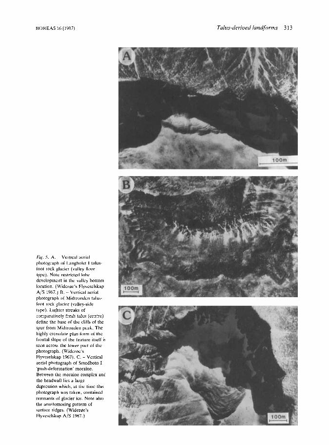
The rock glaciers appear to have developed in three ways. First, a bench may form (cf. Akerman 1984). Second, where benchesform relatively high on a talus slope, it appears that a shear stress thresholdcan be surpassed and a ‘break-away’ lobe may extend downslope, carrying most debris near the front crest (Fig. 5B). For the Rondslottet fea- ture this threshold seems to have been exceeded at different locations and at different times, in view of the low. degraded ridges beyond the bench foot (Fig. 2). This type of rock glacier can be expected to comprise portions of bench and lobe depending on the stability and position on the talus slope. Third. where rock glacier development has
BOREAS 16 (1987)
Fig. 5. A. ~ Vertical aerial photograph of Langholet I talus- foot rock glacier (valley-floor type). Note restricted lobe development in the valley bottom location. (Wideroe’s Flyveselskap A/S 1967.) B. - Vertical aerial photograph of Midtronden talus- foot rock glacier (valley-side type). Lightcr streaks of comparatively fresh talus (centre) define the base of the cliffs of the spur from Midtronden peak. The highly crenulate plan form of the frontal slope of the feature itself is scen across the lower part of the photograph. (Wideroe’s Flyvcselskap 1967). C. - Vertical aerial photograph of Smedbotn I ‘push-deformation’ moraine. Between the moraine complex and the headwall lies a large depression which, at the time this photograph was taken, contained remnants of glacier ice. Note also the anastomosing pattern of surface ridges. (Wideroe’s Flyveselskap A/S 1967.)
Talus-derived landforms 313

314 Richard A. Shakrsby et al. BOREAS 16 (1987)
TALUS SUPPLY
’PUSH-DEFORMATION‘ MORAINE
SIMPLE TALUS SLOPE
PROTALUS RAMPART ROCK GLACIER d
I .&. 6. The non-linear niorpho1ogic;il and de\ elopment;il cont inuum of t a l u d c r i v c d landforms in Rondane. In addition. vallcy-sidc ;rnd valley-floor rock glacier\ arc rccognizcd in this \tiid) *Most thcorica of rock placicr formaticln assumc the prcscncc of interstitial icc. grotind icc o r a n ii‘c coic
occurred entirely on the valley floor, extension has been restricted (c.g. Smedbotn 11 and Langholct 1 )
An age and activity continuum Great age and inactivity of the features is suggested by the consistently large lichens and the often con- tinuous lichen cover on surface boulders. Previous work in southern Norway suggests that maximum lichen sizes over c. 150 mm predate the ‘Little Ice Age‘ (Matthews Rr Shakesby 1984), and in view of the relatively continental climate of Rondane and assuming declining lichen growth rates with time, many surfaces must be considerably older than the ‘Little Ice Age‘.
That lichen sizes on the landforms d o not differ significantly from those characteristic of ‘outside‘ sites suggests relatively uninterrupted growth on the landforms for a considerable time. With no consistent pattern of lichen sizes and Schmidt ham- mer R-values between inner and outer ridges. dif- ferential ages for ridges associated with all but one feature (Smedbotn I) can be rejected. Lichen sizes from ’talus’ sites, however. suggest that talus inputsoccurredduringthe‘Little Ice Age’andcon- tinue today. Present-day talus production is also shown by ‘talus‘ boulders with either an incomplete o r absent lichen cover. Although lichen-free boul- ders are common, the) are not reflected in the data of Table 2 because only the largest lichens were me as ure d .
When the combined Schmidt hammer resultsfor rock glaciers and protalus ramparts were examined for differences between ‘outside’, ‘outer ridge’ and ’talus’ sites using Kolmogorov-Smirnov two- sample tests, the following results were obtained. For rock glaciers, ‘outer ridges’ could be distic- guished statistically from ‘outside’ sites 0, < 0.05) but not from ‘talus’ sites (p > 0.05). For protalus ramparts the ramparts were distinguishable from ’talus’ sites (p < 0.05) but not from ‘outside’ sites. This implies that the protalus ramparts are older or have been stable for longer than the rock glaciers. Support for this conclusion is given by a complete lichen cover on all protalus rampart boulders com- pared with small quantities of fresh material on the rock glaciers near ‘talus’ zones and by the stability of all protalus rampart slopes compared with rock glacier front slopes, which (except for Langholet I and parts of Smedbotn 11) comprise easily dis- lodged debris. The small sizes of lichens on the innermost ridge (and on the long proximal slope) indicate that a major reactivation of Smedbotn I occurred during the ‘Little Ice Age’. In addition, the steepness of the proximal slope suggests com- paratively recent glacier retreat, with only a slightly less steep distal slope suggesting com- paratively recent glacier push.
From these observations an activity continuum can be proposed. with the ‘push-deformation’ moraine being the most active, followed in turn by the rock glaciers and the inactive protalus ramparts. The ‘push-deformation’ moraine was active during the ‘Little Ice Age’ whereas the pro- talus ramparts, being fossil features, clearly were
BOREAS 16 (1987) Talus-derived landforms 3 15
not. Four possibilities for the origin of the rock glaciers can be put forward. First, if Rondane was deglaciated during Preboreal times, the rock gla- ciers may have developed then, when conditions were perhaps particularly favourable. However, rapid deglaciation of Rondane (cf. Barth et al. 1980; Hafsten 1981) suggests, second, that they remained active throughout the Holocene, the large lichens reflecting stable upper surfaces to otherwise active rock glaciers, the lower layers of which continued to move. Third, they may have been intermittently active in the Holocene. Fourth, just as Smedbotn I and the protalus ram- parts differ in their periods of activity so might the rock glaciers (cf. Johnson 1984), both with respect to different features and parts of the same feature.
If ice has been directly or indirectly involved in the motion of the rock glaciers, the possibility of continuous or periodic activity through the Holo- cene is to be favoured since Holocene tempera- tures have been slight and climatic conditions today remain relatively severe. Even during the Climatic Optimum (c. 8,00&5,000 B.P.), with temperatures 2-3°C higher than today (Barth et al. 1980; Hafsten 1981; Caseldine & Matthews 1985), mean annual air temperatures would only just have reached the suggested upper temperature limit of -2°C for rock glacier activity in the Swiss Alps (Barsch 1977). During the 'Little Ice Age', tem- peratures were probably 1-2°C lower than today (Matthews 1976, 1977) so that the features could well have been more active during that period and in other Neoglacial cool phases.
Implications for assessing the activity of talus-derived landforms The indicators of rock glacier activity used in this paper require careful interpretation. The spread of mean Schmidt hammer R-values is low for sites where lichen sizes show considerable age variation and this is attributed largely to boulder surface characteristics. First, freeze-thaw shattering or rockfall leads to an initial rough surface texture which yields similar R-values to weathered boul- ders. By contrast, 50 boulders from the modern Dorilen stream and 50 weathered boulders from a nearby fluvioglacial terrace yielded significantly different mean R-values of 52.4 and 36.7 respect- ively (Kolmogorov-Smirnov two-sample test; p < 0,001). This can be explained by the initial smooth surface compared with the rough surface
developed through weathering. Second, sparag- mite surfaces weather partly by flaking, leading to continual renewal of 'fresh' surfaces. Third, many boulders obviously weakened by weathering along bedding planes were omitted from consideration as Schmidt hammer readings would have reflected sub-surface weaknesses rather than surface hardness.
Lichen sizes from the rock glaciers need to be interpreted with caution in view of the ability of lichens to thrive in relatively unstable conditions (Matthews 1973; Griffey 1978). Continuity of lichens across adjacent surface debris (Luckman & Crockett 1978) or the presence of lichen-covered boulders in the surface hollows otherwise occupied by lichen-free boulders as a result of persistent snow drifts (Foster & Holmes 1965), though not applicable here, would seem more appropriate as diagnostic criteria.
Other frequently-cited indicators of rock glacier age also require cautious use. For example, Smed- botn I1 (with angles up to 54") had the steepest front, yet paradoxically this was the most stable because of interlocking boulders. The other rock glacier fronts reclined mostly at angles < ' cv. Surprisingly, one of the most active talus slopes, with angles up to 37", occurred upslope of the rock glacier with the lowest-angled front slope (28" overall; Langholet I) . Clearly, front slope angles are not always reliable indicators of rock glacier activity.
Conclusion This investigation has highlighted areas of debate concerning the morphology, classification, age and state of activity of rock glaciers, protalus ramparts and related landforms. A morphological and developmental continuum of these landforms is proposed. Rather than a linear, sequential devel- opment of one class of talus-derived landforms to the next (cf. Grotzbach 1965; Corte 1976; Bal- lantyne & Kirkbride 1987), anumberof alternative routes originating from a simple talus slope is envis- aged (Fig. 6). In Rondane, rock glaciers seem to be the 'normal' talus-derived landform with protalus rampart development depending on special con- ditions of debris supply. Variation in talus-foot rock glacier form is well illustrated in the Rondslot- tet feature with lobes developing from a bench form where debris supply and slope conditions have allowed. Lobe extensions are better devel-

316 Richard A . Shakesby et al. BOREAS 16 (1987)
oped in the Midtronden feature because the talus foot terminates above the valley floor along the entire talus slope; consequently, potential for rock glacier movement is greater. By contrast, for talus- foot rock glaciers at the talus slope/valley floor junction (Langholet I and Smedbotn 11), forward motion and therefore extension from the talus foot are limited. Sufficient snowbed growth for restric- ted glacier development was instrumental in the formation of the Smedbotn I ’push-deformation’ moraine.
A separate age and activity continuum has also been recognized with the recency of ac- tivity increasing in the direction: protalus rampart --j rock glacier + ‘push-deformation’ moraine. It is suggested that all the talus-derived landforms in Rondane probably originated in the early Holocene. The protalus ramparts are ‘fossil’ features while the rock glaciers may have been active. perhaps intermittently, throughout the Iiolocene. The ‘push-deformation’ moraine is regarded as the most recently active of the land- forms investigated as it experienced a major phase of activity. and hence major changes in form, dur- ing the ‘Little Ice Age’.
Generally-accepted diagnostic criteria for dis- tinguishing rock glaciers from other talus-derived landforms are found inadequate. ‘Porridge-like appearance’ (Barsch 1977:231) and ‘tongue- shaped or lobate masses of poorly-sorted angular debris’ (Wahrhaftig & Cox 1959:387) are not descriptions exclusive to rock glaciers: the mor- phology of the Verkilsdalen feature matched this description and whilst thought to be a rock glacier by Barsch & Treter (1976). has been shown by Dawson et a/. (1986) to be a landslide. These descriptions are equally appropriate for Smedbotn I , also viewed as a rock glacier by Barsch & Treter (1976), yet our work indicates a glacial origin. The description of a protalus rampart as a ‘ridge of rub- ble or debris that has accumulated piecemeal by rock-fall or debris-fall across a perennial snowbank, commonly at the foot of talus’ (Rich- mond 1962:20) would apply to the Rondane fea- tures ascribed to this origin. However, features regarded as such by Ballantyne & Kirkbride (1987) in several respects (talus-foot extension, constitu- ent material, distal slope angle) resemble features identified here as rock glaciers. Clearly, unam- biguous diagnostic criteria for differentiating between these landforms are needed. Because rock glaciers are slow-moving, lichen sizes and weathering indices are unlikely to be unambiguous
in determining activity. Furthermore, asimplecor- relation between activity and front slope angle seems doubtful. Instability of the uppermost part of the front slope, continuity of lichens across sur- face debris and lichen-covered boulders in other- wise lichen-free hollows might offer better indices of inactivity where no vegetation nor surface fines occur.
Acknowledgements. - This study was carrled ou t on the Uni- versity Collcgc Cardiff and University College Swansca Joint Jotunheimen Rcsearch Expedition 1984. We are gratcful to Andrcb Jones. Pam Nolan and Graham Riley for assistance with fieldwork and to Dr C. K. Ballantyne for comments on an earlicr draft of thc manuscript. Thc expedition was supportcd by the Royal Geographical Society (London) with a British Sugar Award. the University Colleges of Cardiff and Swansca, Coven- t r y (Lanchcstcr) Polytechnic. the National Geographic Society (Washington), the University ot Illinois and the British Gcomor- phological Research Group.
References Akcrman. H. J 1984: Notcs on talus morphology and processes
in Spitshergcn. Geografiska annaler 66A, 267-284. Anderscn, J. L. & Sollid. J . L. 1971: Glacial chronology and
glacicr gcomorphology in thc marginal zones of the glaciers, Midtdalshreen and Nigardshrcen, south Norway. Norskgeog- rufi.rk tidsskrift25. 1-38,
Ballantync, C. K. & Kirkbride, P. 1987: The characteristics and significance of Lateglacial protalus ramparts in upland Britain. Earth Surfaces Processes and Landforms 11,659-672.
Barsch. D. 1971: Rock glaciers and ice-cored moraines. Geog- rafiska annaler 53A, 203213.
Barsch. D. 1977: Nature and importance of mass-wasting by rock glaciers in Alpinc permafrost cnvironments. Earth Surface Processes 2 . 231-245.
Barsch, D. & Trctcr, U. 1976: Zur Verhreitung von Peri- glazialphanomcncn in Rondane/Nonvegcn. Geografiska annaler SRA , 83-93.
Barth, E . K.. Lima-dc-Faria, A . & Berglund, B. E. 19x0: Two “C dates of wood samples from Rondane, Norway. Botanirka notirer 133. 643-644.
Case1dine.C. J . &Matthews, J A. 1985: 14Cdatingofpalaeosols, pollcn analysis and landscape change: studies from the low- and mid-alpine belts of southern Norway. In Boardman, J . (ed.): Soils and Quaternary Lanhcape Euolution, 87-116. Wiley.
Chandler, R. J . 1973: The inclination of talus, Arctic talus terraces, and other slopes composed of granular materials. Journal of Geology 81, 1-14.
Cortk, A. E. 1976: Rockglaciers. Bulletyn Peryglacjalny26,175- 197.
Dahl, E. 1956: Rondane: mountain vegetation in south Norway and its relation to environment. Skrifter utgitt au den Norske Vedemkapsakademi i Oslo, Matematirk-naturuidemkapelig Klnrse 3 , 1-374.
Dawson, A. G., Matthews, J. A. & Shakesby, R. A . 1986: A catastrophic landslide (Sturzstrom) in Verkilsdalen, Rondane National Park, Southern Norway. Ceografika annaler 68A, 77-87.

BOREAS 16 (1987) Talus-derived landforms 317
Foster, H. L. & Holmes, G. W. 1965: A large transitional rock glacierinthe JohnstonRiverarea,AlaskaRange. UnitedStates Geological Survey Professional Paper525B, 112-115.
Giardino, J . R . 1983: Movement of ice-cemented rock glaciers by hydrostatic pressure: an example from Mount Mestas, Colorado. Zeitschrift fur Geomorphologie, Neue Folge 27, 297-3 10.
Giardino, J . R. & Vick, S. G. 1985: Engineering geology hazards of rock glaciers. Bulletin of the Association of Engineering Geologists 22,201-216.
Griffey, N. J . 1978: Lichen growth on supraglacial debris and its implications for lichenometric studies. Journal of Glaciology 20,163-172.
Griffey,N. J . &Whalley, W. B. 1979: Arockglacierandmoraine- ridge complex, Lyngen Peninsula, north Norway. Norsk geog- rafisk tidsskrift33,117-124.
Grotzbach, E. 1965: Beobachtungen an Blockstremen im afgh- anischcn Hindukusch und in den Ostalpen. Mitteilungen der Geographischen Gesellschaft in Munchen 50,175-201.
Hafsten, U. 1981: An8000 year old pine trunk from Dovre, South Norway. Norsk geografisk tidsskrift 35,161-165.
Humlum, 0. 1982: Rock glaciers in northern Spitsbergen: a discussion. Journal of Geology 90,214238,
Johnson, J . P. 1973: Some problems in the study of rock glaciers. In Fahey, B. D. &Thompson, R. D. (eds.): Research in Polar and Alpine Geornorphology, 8494 . 3rd Guelph Symposium on Geomorphology.
Johnson, P. G. 1975: Mass movement processes in Metalline Creek, southwest Yukon Territory. Arctic 28,130-139.
Johnson, P. G. 1983: Rock glaciers. A case for a change in nomenclature. Geografiska annaler 65A, 27-34.
Johnson, P. G. 1984: Rock glacier formation by high magnitude- low frequency slope processes in the southwest Yukon. Annals of the Association of American Geographers 74,408-419.
Lindncr, L. & Marks, L. 1985: Types of debris slope accumu- lations and rock glaciers in south Spitsbergen. Boreas 14,139- 153.
Luckman, B. H. & Crockett, K. J. 1978: Distributionandcharac- teristics of rock glaciers in the southern part of Jasper National Park, Alberta. Canadian Journal of Earth Science 15,540-550.
McCarroll, D. 1987: The Schmidt hammer in geomorphology: five sources of instrument error. Britbh Geomorphological Research Group, Shorter Technical Methods Vl, Technical Bulletin No. 36, 16-27.
moraine, Jotunheimen, Norway. Journal of Glaciology 12. 305-313.
Matthews, J. A . 1974: Families of lichenometric dating cuwes from the Storbreen gletschervorfeld, Jotunheimen, Norway. Norsk geografisk tidsskrift 28,215-235.
Matthews, J. A . 1975: Experiments on the reproducibility and reliability of lichenometric dates, Storbreen gletschcrvorfcld, Jotunheimen Norway. Norsk geografisk tidsskrift 29,977109,
Matthews, J. A . 1976: ‘Little Ice Age’ palaeotcmperaturcs from high altitude tree growth in S. Norway. Nature264.243-245.
Matthews, J. A . 1977: Glacier and climatic fluctuations inferred from tree-growth variations over the last 250 years. central southern Norway. Boreas 6,l-24.
Matthews, J . A . & Petch, J. R. 1982: Within-valley asymmetry and related problems of Neoglacial lateral moraine dcvcl- opment at certain Jotunheimen glaciers, southern Norway. Boreas I1 ~ 225-247.
Matthews,J. A.&Shakesby,R.A. 1984:Thestatusofthc‘Little Ice Age’ in southern Norway: relative-age dating of Neoglacial moraines with Schmidt hammer and lichenometry. Boreas 13. 335346.
Bstrem, G. 1971: Rock glaciers and ice-cored moraines: a reply to D . Barsch. Geografiska annaler 53A, 207-213.
Richmond, G. M. 1962: Quaternary stratigraphy of the La Sal Mountains, Utah. United States Geological Survey Professional Paper324, 135 pp.
Sissons, J. B. 1976: A remarkable protalus complex in Wester- Ross. Scottish Geographical Magazine 92, 182-190.
Sollid, J . L. & Reite, A. J. 1983: The last glaciation and degla- ciation of central Norway. In Ehlers, J . (ed.): GlacialDeposirs in North-west Europe, 41-60, Balkema, Rotterdam.
S t r ~ m , K. 1945: Geomorphology of the Rondane area. Norsk geologisk tidsskrift 25,360-378.
Swett,K., Hambrey, M. J. &Johnson, D. B. 1980: Rockglaciers in Northern Spitsbergen. Journal of Geology 88,475-482.
Vere, D. & Matthews, J. A. 1985: Rock glacier formation from a lateral moraine at Bukkeholsbreen, Jotunheimen. Norway: a sedimentological approach. Zeitschrift fur Geomorphologie, Neue Folge 29,397-415.
Wahrhaftig. C. & Cox, A . 1959: Rock glaciers in the Alaska Range. Bulletin of the Geological Sociery of America 70, 380- 436.
Whalley, W. B. 1979: The relationship of glacier ice and rock glacier at Grubengletscher. Kanton Wallis, Switzerland. Geog-
Matthews, J. A . 1973: Lichen growth on an active medial rafiska annaler 61A, 4 S 6 1