Embed Size (px)
Citation preview
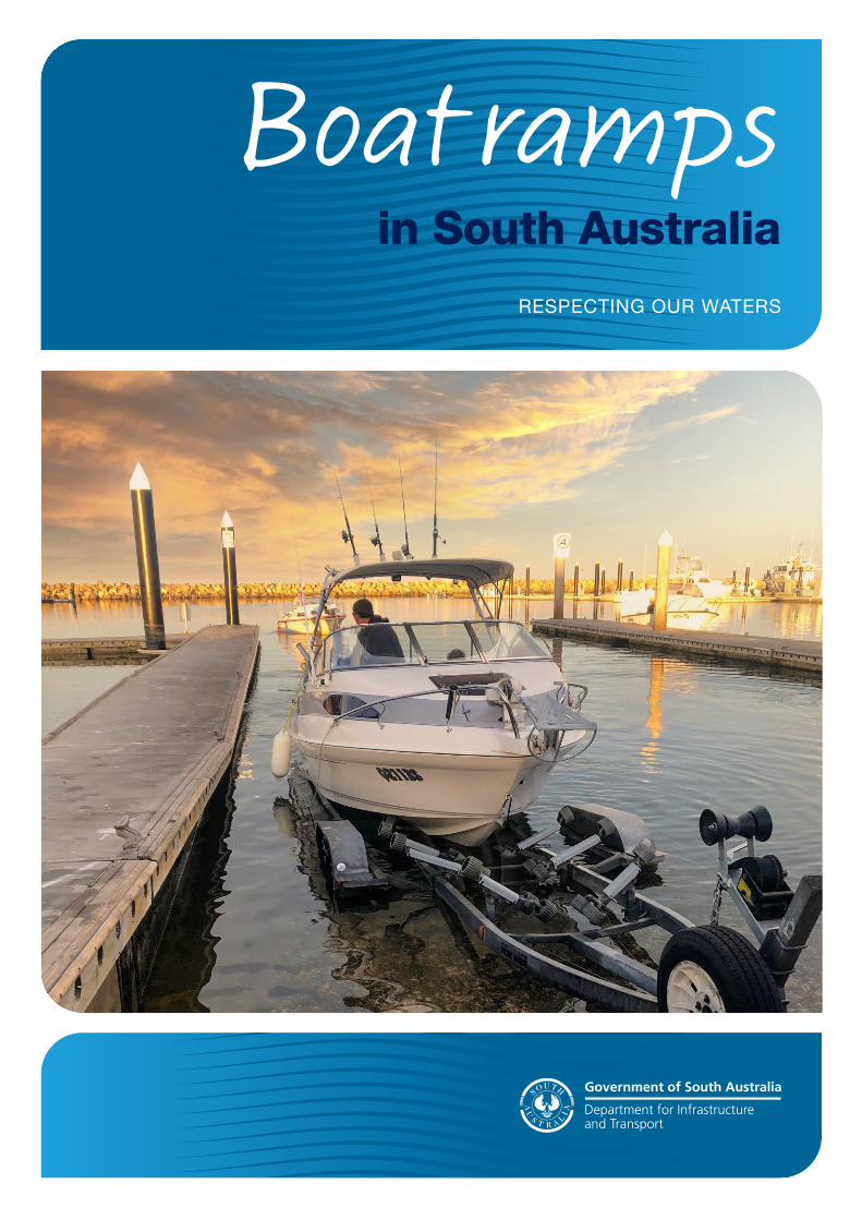
Boat ramps in South Australia
RESPECTING OUR WATERS
2 Boat ramps in South Australia
Boat ramps in South Australia
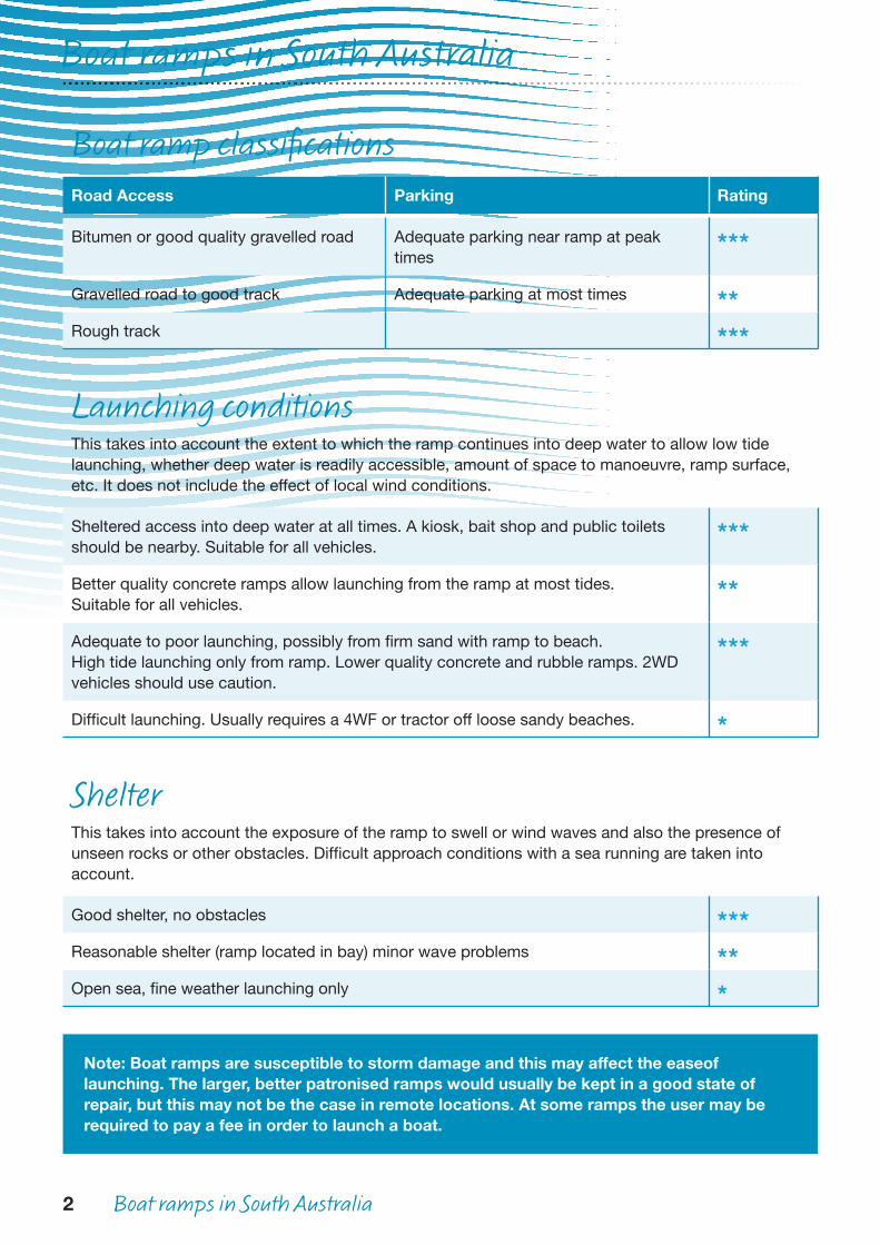
Boat ramp classificationsRoad Access Parking Rating
Bitumen or good quality gravelled road Adequate parking near ramp at peak times
***
Gravelled road to good track Adequate parking at most times **Rough track ***
Launching conditionsThis takes into account the extent to which the ramp continues into deep water to allow low tide launching, whether deep water is readily accessible, amount of space to manoeuvre, ramp surface, etc. It does not include the effect of local wind conditions.
Sheltered access into deep water at all times. A kiosk, bait shop and public toilets should be nearby. Suitable for all vehicles.
***
Better quality concrete ramps allow launching from the ramp at most tides. Suitable for all vehicles.
**
Adequate to poor launching, possibly from firm sand with ramp to beach.High tide launching only from ramp. Lower quality concrete and rubble ramps. 2WD vehicles should use caution.
***
Difficult launching. Usually requires a 4WF or tractor off loose sandy beaches. *
ShelterThis takes into account the exposure of the ramp to swell or wind waves and also the presence of unseen rocks or other obstacles. Difficult approach conditions with a sea running are taken into account.
Good shelter, no obstacles ***Reasonable shelter (ramp located in bay) minor wave problems **Open sea, fine weather launching only *
Note: Boat ramps are susceptible to storm damage and this may affect the ease of launching. The larger, better patronised ramps would usually be kept in a good state of repair, but this may not be the case in remote locations. At some ramps the user may be required to pay a fee in order to launch a boat.
Boat ramps in South Australia 3
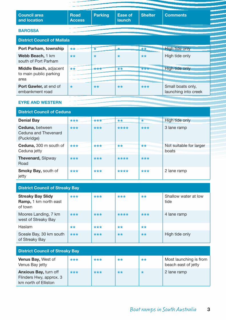
Council areaand location
Road Access
Parking Ease of launch
Shelter Comments
BAROSSA
District Council of Mallala
Port Parham, township ** * * ** High tide only
Webb Beach, 1 km south of Port Parham
** * * ** High tide only
Middle Beach, adjacent to main public parking area
** *** ** *** High tide only
Port Gawler, at end of embankment road
* ** ** *** Small boats only, launching into creek
EYRE AND WESTERN
District Council of Ceduna
Denial Bay *** *** ** * High tide only
Ceduna, between Ceduna and Thevenard (Puckridge)
*** *** **** *** 3 lane ramp
Ceduna, 300 m south of Ceduna jetty
*** *** ** ** Not suitable for larger boats
Thevenard, Slipway Road
*** *** **** ***
Smoky Bay, south of jetty
*** *** **** *** 2 lane ramp
District Council of Streaky Bay
Streaky Bay Slidy Ramp, 1 km north east of town
*** *** *** ** Shallow water at low tide
Moores Landing, 7 km west of Streaky Bay
*** *** **** *** 4 lane ramp
Haslam ** *** ** **Sceale Bay, 30 km south of Streaky Bay
*** *** ** ** High tide only
District Council of Streaky Bay
Venus Bay, West of Venus Bay jetty
*** *** ** ** Most launching is from beach east of jetty
Anxious Bay, turn off Flinders Hwy, approx. 3 km north of Elliston
*** *** ** * 2 lane ramp
4 Boat ramps in South Australia
Council areaand location
Road Access
Parking Ease of launch
Shelter Comments
EYRE AND WESTERN cont.
District Council of Mallala cont.
Elliston, township * * ** ** Beach parking
District Countil of Lower Eyre Peninsula
Farm Beach, 8 km westof Wangary
* *** * * Beach launching
Mount Dutton Bay *** *** *** ***Coffin Bay, adjacent tothe Esplanade
*** *** **** *** 5 lane ramp
Coffin Bay, nearCaravan Park
*** * ** *** High tide only
North Shields, near jetty *** *** *** **Louth Bay township ** * * ** Beach parking
City of Port Lincoln
Billy Lights Point, 6 km south of Port Lincoln
*** *** **** *** 3 lane ramp
Lincoln Cove Marina, adjacent to Dockside Tavern
*** * *** *** 2 lane ramp
Port Lincoln (Proper Bay), west near fish factories
*** *** ** ** High tide only
Port Lincoln, Snapper Rock, 200 m east of power station
*** *** *** ** Slippery rock sometimes
Port Lincoln, north shore, 100 m north of Axel Stenross Slipway
*** *** **** *** 2 lane ramp
Port Lincoln, adjacent to Yacht Club
*** * ** ** No trailer parking
District Council of Tumby Bay
Trinity Haven,Trinity Haven Road,(south Tumby Bay)
** ** * **
Tumby Bay, Marina complex
*** *** **** *** 2 lane ramp
Port Neill, eastern end of shacks
*** *** **** *** 3 lane ramp
Boat ramps in South Australia 5
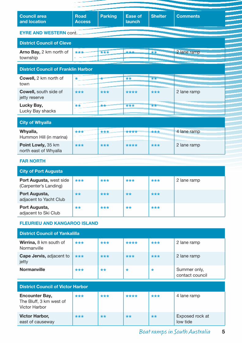
Council areaand location
Road Access
Parking Ease of launch
Shelter Comments
EYRE AND WESTERN cont.
District Council of Cleve
Arno Bay, 2 km north of township
*** *** *** ** 2 lane ramp
District Council of Franklin Harbor
Cowell, 2 km north of town
* * ** **
Cowell, south side ofjetty reserve
*** *** **** *** 2 lane ramp
Lucky Bay,Lucky Bay shacks
** ** *** **
City of Whyalla
Whyalla,Hummon Hill (in marina)
*** *** **** *** 4 lane ramp
Point Lowly, 35 km north east of Whyalla
*** *** **** *** 2 lane ramp
FAR NORTH
City of Port Augusta
Port Augusta, west side(Carpenter’s Landing)
*** *** *** *** 2 lane ramp
Port Augusta,adjacent to Yacht Club
** *** ** ***
Port Augusta,adjacent to Ski Club
** *** ** ***
FLEURIEU AND KANGAROO ISLAND
District Council of Yankalilla
Wirrina, 8 km south of Normanville
*** *** **** *** 2 lane ramp
Cape Jervis, adjacent to jetty
*** *** *** *** 2 lane ramp
Normanville *** ** * * Summer only,contact council
District Council of Victor Harbor
Encounter Bay, The Bluff, 3 km west of Victor Harbor
*** *** **** *** 4 lane ramp
Victor Harbor,east of causeway
*** ** ** ** Exposed rock atlow tide
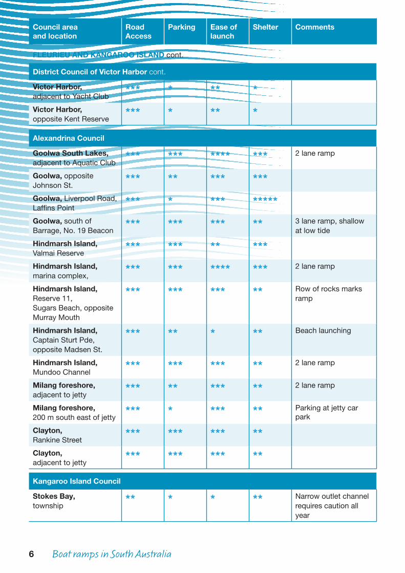
6 Boat ramps in South Australia
Council areaand location
Road Access
Parking Ease of launch
Shelter Comments
FLEURIEU AND KANGAROO ISLAND cont.
District Council of Victor Harbor cont.
Victor Harbor,adjacent to Yacht Club
*** * ** *
Victor Harbor,opposite Kent Reserve
*** * ** *
Alexandrina Council
Goolwa South Lakes,adjacent to Aquatic Club
*** *** **** *** 2 lane ramp
Goolwa, oppositeJohnson St.
*** ** *** ***
Goolwa, Liverpool Road,Laffins Point
*** * *** *****
Goolwa, south ofBarrage, No. 19 Beacon
*** *** *** ** 3 lane ramp, shallow at low tide
Hindmarsh Island,Valmai Reserve
*** *** ** ***
Hindmarsh Island,marina complex,
*** *** **** *** 2 lane ramp
Hindmarsh Island,Reserve 11,Sugars Beach, oppositeMurray Mouth
*** *** *** ** Row of rocks marks ramp
Hindmarsh Island,Captain Sturt Pde,opposite Madsen St.
*** ** * ** Beach launching
Hindmarsh Island,Mundoo Channel
*** *** *** ** 2 lane ramp
Milang foreshore,adjacent to jetty
*** ** *** ** 2 lane ramp
Milang foreshore,200 m south east of jetty
*** * *** ** Parking at jetty car park
Clayton,Rankine Street
*** *** *** **
Clayton,adjacent to jetty
*** *** *** **
Kangaroo Island Council
Stokes Bay,township
** * * ** Narrow outlet channelrequires caution allyear
Boat ramps in South Australia 7
Council areaand location
Road Access
Parking Ease of launch
Shelter Comments
FLEURIEU AND KANGAROO ISLAND cont.
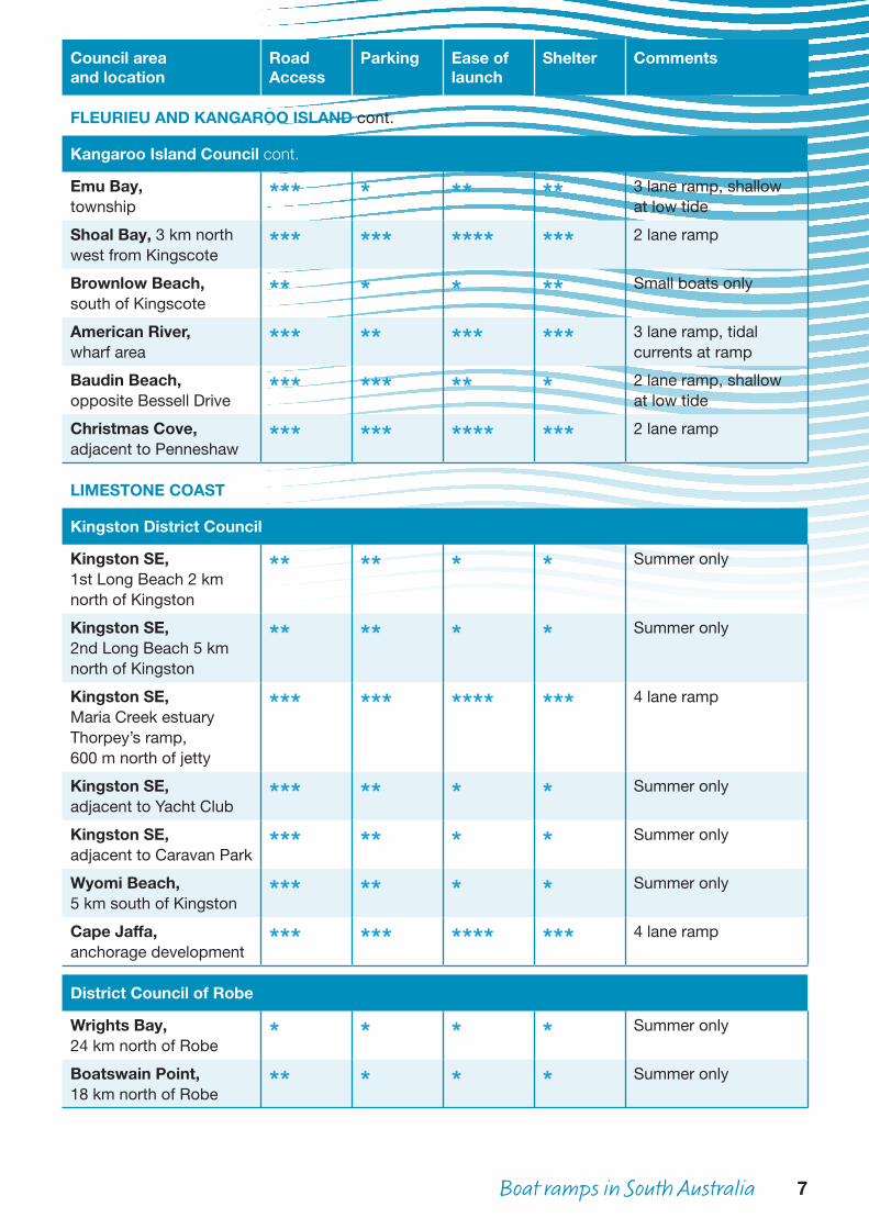
Kangaroo Island Council cont.
Emu Bay,township
*** * ** ** 3 lane ramp, shallow at low tide
Shoal Bay, 3 km northwest from Kingscote
*** *** **** *** 2 lane ramp
Brownlow Beach,south of Kingscote
** * * ** Small boats only
American River,wharf area
*** ** *** *** 3 lane ramp, tidal currents at ramp
Baudin Beach,opposite Bessell Drive
*** *** ** * 2 lane ramp, shallow at low tide
Christmas Cove,adjacent to Penneshaw
*** *** **** *** 2 lane ramp
LIMESTONE COAST
Kingston District Council
Kingston SE,1st Long Beach 2 kmnorth of Kingston
** ** * * Summer only
Kingston SE,2nd Long Beach 5 kmnorth of Kingston
** ** * * Summer only
Kingston SE,Maria Creek estuaryThorpey’s ramp,600 m north of jetty
*** *** **** *** 4 lane ramp
Kingston SE,adjacent to Yacht Club
*** ** * * Summer only
Kingston SE,adjacent to Caravan Park
*** ** * * Summer only
Wyomi Beach,5 km south of Kingston
*** ** * * Summer only
Cape Jaffa,anchorage development
*** *** **** *** 4 lane ramp
District Council of Robe
Wrights Bay,24 km north of Robe
* * * * Summer only
Boatswain Point,18 km north of Robe
** * * * Summer only
8 Boat ramps in South Australia
Council areaand location
Road Access
Parking Ease of launch
Shelter Comments
LIMESTONE COAST cont.
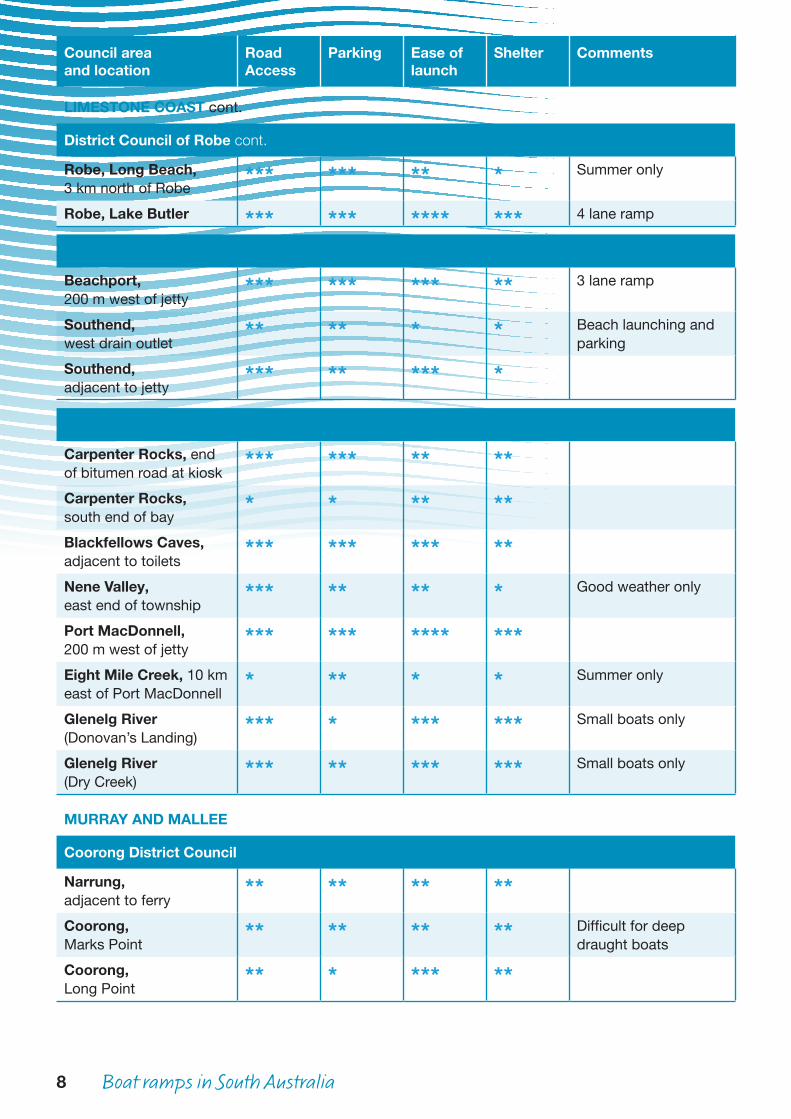
District Council of Robe cont.
Robe, Long Beach,3 km north of Robe
*** *** ** * Summer only
Robe, Lake Butler *** *** **** *** 4 lane ramp
Wattle Range Council
Beachport,200 m west of jetty
*** *** *** ** 3 lane ramp
Southend,west drain outlet
** ** * * Beach launching and parking
Southend,adjacent to jetty
*** ** *** *
District Council of Grant
Carpenter Rocks, endof bitumen road at kiosk
*** *** ** **
Carpenter Rocks,south end of bay
* * ** **
Blackfellows Caves,adjacent to toilets
*** *** *** **
Nene Valley,east end of township
*** ** ** * Good weather only
Port MacDonnell,200 m west of jetty
*** *** **** ***
Eight Mile Creek, 10 kmeast of Port MacDonnell
* ** * * Summer only
Glenelg River(Donovan’s Landing)
*** * *** *** Small boats only
Glenelg River(Dry Creek)
*** ** *** *** Small boats only
MURRAY AND MALLEE
Coorong District Council
Narrung,adjacent to ferry
** ** ** **
Coorong,Marks Point
** ** ** ** Difficult for deepdraught boats
Coorong,Long Point
** * *** **
Boat ramps in South Australia 9
Council areaand location
Road Access
Parking Ease of launch
Shelter Comments
MURRAY AND MALLEE cont.
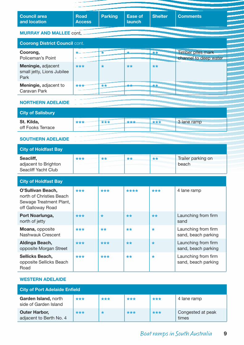
Coorong District Council cont.
Coorong,Policeman’s Point
* * * ** Timber piles markchannel to deep water
Meningie, adjacent small jetty, Lions Jubilee Park
*** * ** **
Meningie, adjacent toCaravan Park
*** ** ** **
NORTHERN ADELAIDE
City of Salisbury
St. Kilda,off Fooks Terrace
*** *** *** *** 3 lane ramp
SOUTHERN ADELAIDE
City of Holdfast Bay
Seacliff,adjacent to Brighton Seacliff Yacht Club
*** ** ** ** Trailer parking on beach
City of Holdfast Bay
O’Sullivan Beach,north of Christies BeachSewage Treatment Plant,off Galloway Road
*** *** **** *** 4 lane ramp
Port Noarlunga,north of jetty
*** * ** ** Launching from firmsand
Moana, oppositeNashwauk Crescent
*** ** ** * Launching from firmsand, beach parking
Aldinga Beach,opposite Morgan Street
*** *** ** * Launching from firmsand, beach parking
Sellicks Beach, opposite Sellicks Beach Road
*** *** ** * Launching from firmsand, beach parking
WESTERN ADELAIDE
City of Port Adelaide Enfield
Garden Island, northside of Garden Island
*** *** *** *** 4 lane ramp
Outer Harbor,adjacent to Berth No. 4
*** * *** *** Congested at peaktimes
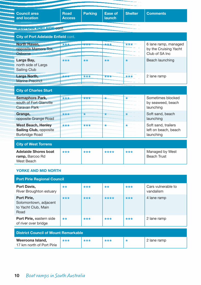
10 Boat ramps in South Australia
Council areaand location
Road Access
Parking Ease of launch
Shelter Comments
WESTERN ADELAIDE cont.
City of Port Adelaide Enfield cont.
North Haven,opposite Mamora Tce,Osborne
*** *** *** *** 6 lane ramp, managed by the Cruising Yacht Club of SA Inc
Largs Bay,north side of LargsSailing Club
*** ** ** * Beach launching
Largs North,Marine Precinct
*** *** *** *** 2 lane ramp
City of Charles Sturt
Semaphore Park,south of Fort GlanvilleCaravan Park
*** *** * * Sometimes blocked by seaweed, beach launching
Grange,opposite Grange Road
*** * * * Soft sand, beach launching
West Beach, HenleySailing Club, oppositeBurbridge Road
*** *** * * Soft sand, trailers left on beach, beach launching
City of West Torrens
Adelaide Shores boatramp, Barcoo RdWest Beach
*** *** **** *** Managed by WestBeach Trust
YORKE AND MID NORTH
Port Pirie Regional Council
Port Davis,River Broughton estuary
** *** ** *** Cars vulnerable tovandalism
Port Pirie, Solomontown, adjacent to Yacht Club, Main Road
*** *** **** *** 4 lane ramp
Port Pirie, eastern side of river over bridge
** *** *** *** 2 lane ramp
District Council of Mount Remarkable
Weeroona Island, 17 km north of Port Pirie
*** *** *** * 2 lane ramp

Boat ramps in South Australia 11
Council areaand location
Road Access
Parking Ease of launch
Shelter Comments
YORKE AND MID NORTH cont.
Port Pirie Regional Council cont.
Fishermans Bay, 5 kmnorth of Port Broughton
*** ** *** *** 2 lane ramp, channel difficult to navigate
Port Broughton,opposite North Terrace
*** *** **** *** 3 lane ramp
Tickera, foreshore ** *** ** **District Council of the Copper Coast
Wallaroo,Copper Cove Marina
*** *** **** *** 4 lane ramp
Wallaroo, Bird IslandRoad, 6 km south oftown
* ** * ** Launching from widestoney beach
Port Hughes,north of jetty
*** ** **** *** 5 lane ramp
District Council of Yorke Peninsula
Balgowan *** ** *** **Port Victoria,2 km south of township
*** *** **** *** 3 lane ramp
Port Rickaby,north of jetty
*** ** ** *
Bluff Beach,west of Minlaton
** ** ** **
Port Minlacowie * *** *** **Hardwicke Bay,southern end township
*** *** * ** Beach launching
Point Turton,adjacent to jetty
*** *** **** *** 3 lane ramp
Burners Beach,2 km south of PointSoutter
** ** ** ** Good natural stonesurface, care requiredto avoid offshore rocks
The Pines, 10 km eastof Corny Point
** ** ** *
Pondalowie Bay,Innes National Park
** * * *** Beach launching
Marion Bay,adjacent to jetty
*** *** ** **
Foul Bay,2 km south west ofshacks
** ** ** **
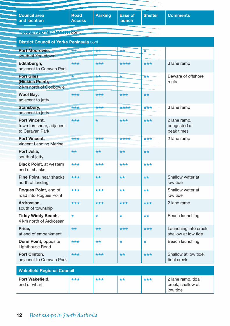
12 Boat ramps in South Australia
Council areaand location
Road Access
Parking Ease of launch
Shelter Comments
YORKE AND MID NORTH cont.
District Council of Yorke Peninsula cont.
Port Moorowie,south of Yorketown
** ** ** *
Edithburgh,adjacent to Caravan Park
*** *** **** *** 3 lane ramp
Port Giles(Hickies Point),2 km north of Coobowie
* ** * ** Beware of offshorereefs
Wool Bay,adjacent to jetty
*** *** *** **
Stansbury,adjacent to jetty
*** *** **** *** 3 lane ramp
Port Vincent,town foreshore, adjacentto Caravan Park
*** * *** *** 2 lane ramp,congested atpeak times
Port Vincent,Vincent Landing Marina
*** *** **** *** 2 lane ramp
Port Julia,south of jetty
** ** ** **
Black Point, at westernend of shacks
*** *** *** ***
Pine Point, near shacksnorth of landing
*** ** ** ** Shallow water atlow tide
Rogues Point, end ofroad into Rogues Point
*** *** ** ** Shallow water atlow tide
Ardrossan,south of township
*** *** *** *** 2 lane ramp
Tiddy Widdy Beach,4 km north of Ardrossan
* * * ** Beach launching
Price,at end of embankment
** ** *** *** Launching into creek,shallow at low tide
Dunn Point, oppositeLighthouse Road
*** ** * * Beach launching
Port Clinton,adjacent to Caravan Park
*** *** ** *** Shallow at low tide,tidal creek
Wakefield Regional Council
Port Wakefield,end of wharf
*** *** ** *** 2 lane ramp, tidalcreek, shallow atlow tide