Embed Size (px)
Citation preview

Blind Pass – Inlet Management Plan
March 2017, Page i
Final Order Adopting Blind Pass - Inlet Management Plan
WHEREAS in 2008, the Florida Legislature amended Section 161.142, Florida Statutes, finding,
“The Legislature recognizes the need for maintaining navigation inlets to promote commercial
and recreational uses of our coastal waters and their resources. The Legislature further
recognizes that inlets interrupt or alter the natural drift of beach-quality sand resources, which
often results in these sand resources being deposited in nearshore areas or in the inlet channel, or
in the inland waterway adjacent to the inlet, instead of providing natural nourishment to the
adjacent eroding beaches. Accordingly, the Legislature finds it is in the public interest to
replicate the natural drift of sand which is interrupted or altered by inlets to be replaced and for
each level of government to undertake all reasonable efforts to maximize inlet sand bypassing to
ensure that beach-quality sand is placed on adjacent eroding beaches. Such activities cannot
make up for the historical sand deficits caused by inlets but shall be designed to balance the
sediment budget of the inlet and adjacent beaches and extend the life of proximate beach-
restoration projects so that periodic nourishment is needed less frequently.” And
WHEREAS in 2015, the Department of Environmental Protection (Department) and Pinellas
County sponsored an inlet management study of Blind Pass performed by the University of
South Florida Coastal Research Laboratory (USF-CRL) to compile new and historical data and
information regarding its coastal processes and inlet and shoreline dynamics and update its
sediment budget, and
WHEREAS in 2016, the USF-CRL completed the inlet management study for Blind Pass, which
included recommendations for inlet management alternatives, and
WHEREAS, on March 2nd, 2017, the Department developed an inlet management plan that
contains corrective measures to mitigate the identified inlet erosion impacts to adjacent beaches,
and
WHEREAS, Pinellas County and the U.S. Army Corps of Engineers are the entities responsible
for dredging at Blind Pass, and therefore, responsible for implementation of the inlet
management plan, and

Blind Pass – Inlet Management Plan
March 2017, Page ii
WHEREAS, this inlet management plan is consistent with the Department’s program objectives
under Chapter 161, Florida Statutes,
THEREFORE:
The Department does hereby adopt the following implementation strategies as set forth in the attached
“Blind Pass Inlet Management Plan – 2016.” Future inlet management activities shall be consistent with the
following four strategies:
1) A comprehensive beach and inlet hydrographic monitoring program shall be
conducted to evaluate the performance and impact of existing sand bypassing and
nourishment projects and to periodically update the inlet sediment budget.
2) Sand bypassing shall be performed from the Blind Pass entrance channel borrow
area to the adjacent gulf-fronting beaches both to the north and to the south of the
inlet within designated critically eroded areas between FDEP Reference Monuments
R136 and R148. The quantity of fill to be placed in each area shall be based on
observed beach erosion patterns and quantities documented through the monitoring
protocol of Strategy #1 above.
3) The initial target inlet sand bypassing quantities shall be 31,000 cubic yards per
year to the south of the inlet and 12,000 cubic yards per year to the north. These
target quantities may be modified based on a minimum of four years of monitoring
indicating a change in the sediment budget. In the interim, should the volume of sand
accumulating in the Blind Pass entrance channel borrow area exceed these quantities, the
additional sand may be dredged and placed on the adjacent beaches to extend the life of
the adjacent beach restoration projects.
4) The source of sediment for meeting the target sand bypassing quantities in Strategy
#3 above shall be the Blind Pass entrance channel borrow area. Acceptable beach
quality sand may also be obtained from inland sand mines or offshore sources to
supplement the target sand bypassing quantities or to facilitate development and growth
of the Blind Pass ebb shoal.

Blind Pass – Inlet Management Plan
March 2017, Page iii
Inlet management actions that implement the strategies contained in this plan are subject to
further evaluation, and subsequent authorization or denial, as part of the Department’s permitting
process. Activities that implement these adopted strategies shall be eligible for state financial
participation pursuant to Section 161.143, Florida Statutes, subject to Department approval and
an appropriation from the Florida Legislature. The level of State funding shall be determined
based on the activity being conducted and the Department’s rules. The Department may choose
not to participate financially if the proposed method of implementation is not cost effective or
fails to meet the intent of Section 161.142, Florida Statutes, and this final order. Nothing in this
plan precludes the evaluation and potential adoption of other strategies for the effective
management of Blind Pass and the adjacent beaches.
Execution of this Final Order constitutes agency action. Any Florida corporation not for profit
which meets the requirements of Subsection 403.412(6), Florida Statutes, and any person whose
substantial interests will be determined or affected by the Final Order may petition the
Department for a formal or informal administrative hearing pursuant to Section 120.569 or
120.57, Florida Statutes, as set forth in the attached Notice of Rights, to challenge the provisions
of this Final Order.
If the Department proposes to issue a permit that implements the strategies in this Final Order,
any Florida corporation not for profit which meets the requirements of Subsection 403.412(6),
Florida Statutes, and any person whose substantial interests will be determined or affected by the
proposed permit may petition the Department for a formal or informal administrative hearing
pursuant to Section 120.569 or 120.57, Florida Statutes, as set forth in the Notice of Rights
attached to the permit. The scope of a challenge to a permit approval or denial is limited to
whether the agency action complies with the permitting criteria. Agency action previously
subject to challenge or administrative review will not be subject to challenge at the time of
permit approval or denial.

Blind Pass – Inlet Management Plan
March 2017, Page iv
Approval of Adoption
_______________________________
Justin B. Green
Director of Division of Water Resource Management
Florida Department of Environmental Protection
Filing and Acknowledgement
FILED, on this date with the designated Department Clerk, pursuant to
Section 120.52, F.S., receipt of which is hereby acknowledged.
____03/02/2017______
Deputy Clerk Date

Blind Pass – Inlet Management Plan
March 2017, Page v
Notice of Rights The Department’s proposed agency action shall become final unless a timely petition for an
administrative hearing is filed under Sections 120.569 and 120.57, Florida Statutes, before the
deadline for filing a petition. The procedures for petitioning for a hearing are set forth below.
A person whose substantial interests are affected by the Department’s proposed action decision
may petition for an administrative proceeding (hearing) under Sections 120.569 and 120.57,
Florida Statutes. The petition must contain the information set forth below and must be filed
(received by the clerk) in the Office of General Counsel of the Department at 3900
Commonwealth Boulevard, Mail Station 35, Tallahassee, Florida 32399-3000. Petitions must be
filed within twenty-one days of receipt of this written notice.
Under Rule 62-110.106(4), Florida Administrative Code, a person whose substantial interests are
affected by the Department’s action may request an extension of time to file a petition for an
administrative hearing. Requests for extension of time must be filed (received by the clerk) with
the Office of General Counsel of the Department at 3900 Commonwealth Boulevard, Mail
Station 35, Tallahassee, Florida 32399-3000, before the end of the time period for filing a
petition for an administrative hearing. The Department may, for good cause shown, grant the
request for an extension of time. A timely request for extension of time shall toll the running of
the time period for filing a petition until the request is acted upon.
Petitions filed by any persons other than those entitled to written notice under Section 120.60(3),
Florida Statutes, must be filed within twenty-one days of publication of the notice or within
twenty-one days of receipt of the written notice, whichever occurs first. Under Section
120.60(3), Florida Statutes, however, any person who asked the Department for notice of agency
action may file a petition within twenty-one days of receipt of such notice, regardless of the date
of publication.
The failure of any person to file a petition or request for extension of time within the appropriate
time period shall constitute a waiver of that person’s right to request an administrative
determination (hearing) under Sections 120.569 and 120.57, Florida Statutes, or to intervene in
this proceeding and participate as a party to it. Any subsequent intervention (in a proceeding
Blind Pass – Inlet Management Plan
March 2017, Page vi
initiated by another party) will be only at the discretion of the presiding officer upon the filing of
a motion in compliance with Rule 28-106.205, Florida Administrative Code.
A petition that disputes the material facts on which the Department’s action is based must
contain the following information:
(a) The name and address of each agency affected and each agency’s file or
identification number, if known;
(b) The name, address, and telephone number of the petitioner; the name, address,
and telephone number of the petitioner’s representative, if any, which shall be the
address for service purposes during the course of the proceeding; and an
explanation of how the petitioner’s substantial interests are or will be affected by
the agency determination;
(c) A statement of when and how the petitioner received notice of the agency
decision;
(d) A statement of all disputed issues of material fact. If there are none, the petition
must so indicate;
(e) A concise statement of the ultimate facts alleged, including the specific facts that
the petitioner contends warrant reversal or modification of the agency’s proposed
action;
(f) A statement of the specific rules or statutes that the petitioner contends require
reversal or modification of the agency’s proposed action; and
(g) A statement of the relief sought by the petitioner, stating precisely the action that
the petitioner wishes the agency to take with respect to the agency’s proposed
action.
A petition that does not dispute the material facts on which the Department’s action is based
shall state that no such facts are in dispute and otherwise shall contain the same information as
set forth above, as required by Rule 28-106.301, Florida Administrative Code.
Blind Pass – Inlet Management Plan
March 2017, Page vii
Because the administrative hearing process is designed to formulate final agency action, the
filing of a petition means that the Department’s final action may be different from the position
taken by it in this notice. Persons whose substantial interests will be affected by any such final
decision of the Department have the right to petition to become a party to the proceeding, in
accordance with the requirements set forth above.
Mediation under Section 120.573, Florida Statutes, is not available.
Once this decision becomes final, any party to the final agency action has the right to seek
judicial review of it under Section 120.68, Florida Statutes, by filing a notice of appeal under
Rule 9.110 of the Florida Rules of Appellate Procedure with the clerk of the Department in the
Office of General Counsel, Mail Station 35, 3900 Commonwealth Boulevard, Tallahassee,
Florida 32399-3000, and by filing a copy of the notice of appeal accompanied by the applicable
filing fees with the appropriate district court of appeal. The notice of appeal must be filed within
thirty days after this decision is filed with the clerk of the Department.

Blind Pass – Inlet Management Plan
March 2017, Page viii
Table of Contents
Introduction ..................................................................................................................................... 1
Program Objectives and Statutory Responsibilities for Inlet Management .................................... 1
History of Blind Pass (Mehta et al, 1976; USCOE, 1966; Wang et al, 2016) ................................ 2
Inlet Management Study ................................................................................................................. 8
Updated Sediment Budget through 2015 (Wang et al, 2016) ....................................................... 14
Recommended Inlet Management Plan Strategies ....................................................................... 18
References ..................................................................................................................................... 20

Blind Pass – Inlet Management Plan
March 2017, Page 1 of 20
BLIND PASS – INLET MANAGEMENT PLAN
Introduction
Pursuant to Subsection 161.101(2), Florida Statutes, the Florida Department of Environmental
Protection (Department) is the beach and shore preservation authority for the State of Florida. As
part of the Department’s statewide beach management plan adopted pursuant to Section 161.161,
Florida Statutes, the Department is adopting this inlet management plan for Blind Pass in
Pinellas County, Florida.
Blind Pass - Inlet Management Plan updates strategies for Blind Pass adopted in the Strategic
Beach Management Plan (FDEP, 2015) to be consistent with current statutes and observed
erosion1 conditions. As a first step towards adoption of this inlet management plan, in 2015-16,
the Department and Pinellas County sponsored a study of Blind Pass performed by the
University of South Florida Coastal Research Laboratory (USF-CRL) to compile new and
historical data and information regarding beach and inlet changes and the dynamic coastal littoral
processes in this area, and develop an updated sediment budget.
Program Objectives and Statutory Responsibilities for Inlet Management
In 2008, the Florida Legislature amended Section 161.142, Florida Statutes, finding,
“The Legislature recognizes the need for maintaining navigation inlets to promote
commercial and recreational uses of our coastal waters and their resources. The Legislature
further recognizes that inlets interrupt or alter the natural drift of beach-quality sand
resources, which often results in these sand resources being deposited in nearshore areas or in
the inlet channel, or in the inland waterway adjacent to the inlet, instead of providing natural
nourishment to the adjacent eroding beaches. Accordingly, the Legislature finds it is in the
_________________________________________________________________________
1 As used in this document, the term “erosion” means wearing away of land or the removal of consolidated or unconsolidated material from the coastal system by wind or wave action, storm surge, tidal or littoral currents or surface water runoff. As used in this document, the term “accretion” means the buildup of land or accumulation of unconsolidated material within the coastal system caused by wind and wave action, storm surge, or tidal or littoral currents. The descriptions of coastal processes in this document are not intended to affect title to real property or real property boundaries.

Blind Pass – Inlet Management Plan
March 2017, Page 2 of 20
public interest to replicate the natural drift of sand which is interrupted or altered by inlets to
be replaced and for each level of government to undertake all reasonable efforts to maximize
inlet sand bypassing to ensure that beach-quality sand is placed on adjacent eroding beaches.
Such activities cannot make up for the historical sand deficits caused by inlets but shall be
designed to balance the sediment budget of the inlet and adjacent beaches and extend the life
of proximate beach restoration projects so that periodic nourishment is needed less
frequently.”
Pursuant to Section 161.143, Florida Statutes,
“Studies, projects and activities for the purpose of mitigating the erosive effects of inlets and
balancing the sediment budget on the inlet and adjacent beaches must be supported by
separately approved inlet management plans or inlet components of the statewide
comprehensive beach management plan.”
The U.S. Army Corps of Engineers (USACE) and Pinellas County have been the entities
responsible for maintenance dredging the Blind Pass entrance channel borrow area and
consequently, mitigating the extent of beach erosion caused by the inlet, as specified in
Subsection 161.142 (6), Florida Statutes.
History of Blind Pass (Mehta et al, 1976; USCOE, 1966; Wang et al, 2016)
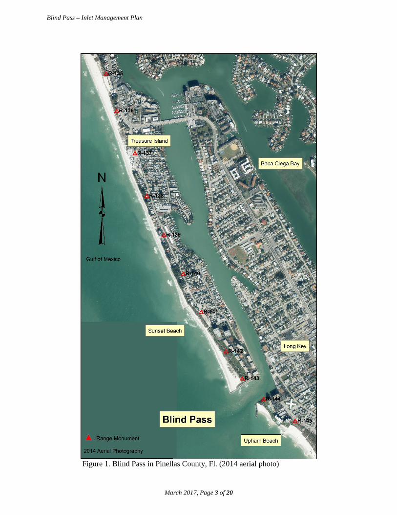
Blind Pass is in Pinellas County on the southwest Gulf of Mexico coast of Florida separating the
barrier islands of Treasure Island to the north and Long Key to the south (Figure 1). The inlet
connects the Gulf of Mexico to Boca Ciega Bay. It is important to understand the history of
Blind Pass, its geomorphological evolution and prior inlet management activities, and beach
erosion control activities along the adjacent beaches, to gain a perspective on the inlet’s
dynamics and the need to change inlet management strategies over time. Over the past century
and a half, Blind Pass has experienced three epochs of different inlet management approaches.
From the 19th century to 1937, there was a general lack of management as nature was allowed to
take its course. Between 1937 and 1968, the construction of rigid structures (seawalls,
bulkheads, groins, and jetties) comprised the inlet’s management activities. From 1969 to date,
excavation of sediment from the inlet’s entrance channel and placement of the dredged material
along the adjacent beaches has been the principle management activity, along with extending the
jetties.
Blind Pass – Inlet Management Plan
March 2017, Page 3 of 20
Figure 1. Blind Pass in Pinellas County, Fl. (2014 aerial photo)

Blind Pass – Inlet Management Plan
March 2017, Page 4 of 20
Blind Pass has a history of dynamic morphological changes dominated by a southward migration
(Figure 2). Between 1873 and 1926, Blind Pass migrated southward approximately 3,900 feet.
Between 1926 and 1939, the inlet migrated another 2,200 feet for a total of 6,100 feet. As Blind
Pass migrated southward, the south end of Treasure Island grew through the accumulation of
sediment. Starting in 1937, the location of Blind Pass became stabilized with various structures.
A small 90-foot long jetty was constructed on the south side of the inlet to prevent further
southward inlet migration in 1937. This structure was extended further landward in the 1950s.
Figure 2. Southward migration of Blind Pass following the opening of John’s Pass in 1848. (Note that Blind Pass was stabilized in 1937 and the location of 1957 is the same as that in 1937.) [reference – Mehta et al., 1976]

Blind Pass – Inlet Management Plan
March 2017, Page 5 of 20
Natural fluctuations in shoreline position along southern Treasure Island and northern Long Key
has occurred over time as observed on aerial photography and shoreline surveys (Figure 3).
Beach erosion control activities on Treasure Island and Long Key have been conducted since
1960, and include shore-protection structures, beach restoration and nourishment, and inlet sand
bypassing. In 1960, 56 groins were constructed on Treasure Island. These groins were
constructed of timber and were only partially successful at mitigating shoreline erosion. In 1962,
a 425-foot jetty was constructed on the north side of Blind Pass by the USACE. The inlet
channel was dredged in 1964 and 10,000 cubic yards of sand was placed on the south end of
Treasure Island, in a location named Sunset Beach. In 1968, another 30,000 cubic yards of sand
was dredged from Blind Pass and placed at an undocumented site.
Figure 3. Historical aerial photos of Blind Pass showing both erosion and accretion to the adjacent shorelines (various sources: U.S. Dept. of Commerce; FL Dept. of Transportation; USF-CRL).
In 1968, the Board of Trustees for the Internal Improvement Trust Fund of the State of Florida
granted the USACE an easement to conduct a beach restoration project on Treasure Island. The
beach restoration project was constructed by the USACE in 1969 and included the placement of
790,000 cubic yards of beach fill along the gulf shoreline between FDEP reference monuments
R132 and R140, or from 104th Avenue to 77th Avenue. Approximately 108,000 cubic yards of
sand was dredged from Blind Pass and spread along southern Treasure Island; the remainder was
obtained from borrow pits located immediately offshore.
In 1972, 155,000 cubic yards of sand was excavated from borrow areas off the south end of
Treasure Island and placed on Sunset Beach between reference monuments R141 and R142. In

Blind Pass – Inlet Management Plan
March 2017, Page 6 of 20
1974, a breakwater was constructed on the south side of the inlet. In 1975, two king-pile groins
were constructed on Upham Beach, which is just south of Blind Pass on Long Key and 75,000
cubic yards of sand was dredged from the Blind Pass and placed on Upham Beach. In 1976,
405,000 cubic yards of sand was dredged from Blind Pass and offshore, and placed north of
Blind Pass along the southern one-third of Treasure Island between monuments R135 and R142.
Also in 1976, the USACE constructed an extension to the Blind Pass north jetty and officially
called it a “terminal groin” to anchor the Treasure Island beach restoration project at Sunset
Beach. In addition, a boulder mound groin with a length of 285 feet was constructed 2,300 feet
north of the inlet near monument R141. Despite the north jetty/terminal groin extension,
southward transport of nourishment material from Treasure Island shoaled in Blind Pass closing
it to tidal flow in 1978. That prompted the USACE to conduct emergency dredging within Blind
Pass, removing 50,000 cubic yards of sand and placing it on Sunset Beach.
From 1980 to date, Blind Pass has been dredged on numerous occasions and the sand has been
placed on both Sunset Beach to the north and on Upham Beach to the south of Blind Pass.
Table 1 provides a list of the recent dredging projects at Blind Pass, as well as other dredging
projects with borrow areas located at the ebb shoals of Johns Pass, Pass-a-Grille, and Egmont
Channel, that had fill placements on either Sunset Beach or Upham Beach. The terminal groin at
Blind Pass was extended again in 1983. In 1985, Labor Day’s Hurricane Elena and Halloween’s
Tropical Storm Juan each lingered in the gulf for a couple days causing storm erosion of area
beaches. In 1986, the U.S. Congress responded with post-storm emergency funding resulting in
the USACE excavating sand from the Pass-a-Grille ebb shoal and placing the material along
Treasure Island between reference monuments R129 and R141 and on Upham Beach between
reference monuments R144 and R146. In addition, the south jetty was extended southward but
was not connected to the breakwater. To mitigate the chronic erosion occurring at Upham
Beach, the gap was closed between the south jetty and the breakwater and five sand-filled
geotextile T-groins were installed along Upham Beach in 2006.

Blind Pass – Inlet Management Plan
March 2017, Page 7 of 20
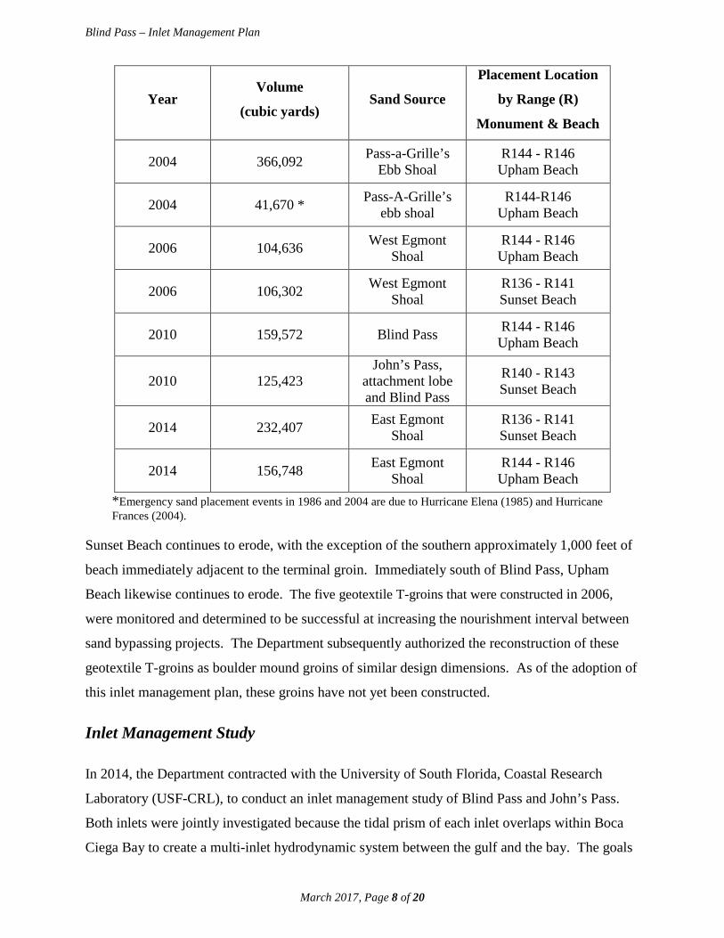
Table 1. Sand Placement at Sunset Beach and Upham Beach (Wang et al., 2016; data from
USACE)
Year Volume
(cubic yards) Sand Source
Placement Location
by Range (R)
Monument & Beach
1969 790,000 Blind Pass and Offshore
R132-R141
Sunset Beach
1971 75,000 Offshore R131-R132
Mid Beach, Treasure Island
1972 155,000 Blind Pass R141-R142
Sunset Beach
1976 380,000 Offshore R135-R142
Sunset Beach
1978 32,000 Blind Pass R135-R142
Sunset Beach
1980 253,760 Blind Pass R144 - R146
Upham Beach
1983 220,000 Blind Pass R138 - R142 Sunset Beach
1986 550,000 * Pass-A-Grille’s ebb shoal
R129 - R141 Treasure Island and
Sunset Beach
1986 96,712 Pass-A-Grille’s ebb shoal
R144 - R146 Upham Beach
1991 229,950 Pass-A-Grille’s ebb shoal
R144 - R146 Upham Beach
1996 252,950 West Egmont Shoal
R144 - R146 Upham Beach
1996 51,300 West Egmont Shoal
R138 - R144 Sunset Beach
2000 348,722 Blind Pass and John’s Pass
R136-R144 Sunset Beach
2000 358,900 Blind Pass and John’s Pass
R144-R146 Upham Beach
2004 225,000 Pass-a-Grille’s Ebb Shoal
R136 - R141 Sunset Beach
Blind Pass – Inlet Management Plan
March 2017, Page 8 of 20
Year Volume
(cubic yards) Sand Source
Placement Location
by Range (R)
Monument & Beach
2004 366,092 Pass-a-Grille’s Ebb Shoal
R144 - R146 Upham Beach
2004 41,670 * Pass-A-Grille’s ebb shoal
R144-R146 Upham Beach
2006 104,636 West Egmont Shoal
R144 - R146 Upham Beach
2006 106,302 West Egmont Shoal
R136 - R141 Sunset Beach
2010 159,572 Blind Pass R144 - R146 Upham Beach
2010 125,423 John’s Pass,
attachment lobe and Blind Pass
R140 - R143 Sunset Beach
2014 232,407 East Egmont Shoal
R136 - R141 Sunset Beach
2014 156,748 East Egmont Shoal
R144 - R146 Upham Beach
*Emergency sand placement events in 1986 and 2004 are due to Hurricane Elena (1985) and Hurricane Frances (2004).
Sunset Beach continues to erode, with the exception of the southern approximately 1,000 feet of
beach immediately adjacent to the terminal groin. Immediately south of Blind Pass, Upham
Beach likewise continues to erode. The five geotextile T-groins that were constructed in 2006,
were monitored and determined to be successful at increasing the nourishment interval between
sand bypassing projects. The Department subsequently authorized the reconstruction of these
geotextile T-groins as boulder mound groins of similar design dimensions. As of the adoption of
this inlet management plan, these groins have not yet been constructed.
Inlet Management Study
In 2014, the Department contracted with the University of South Florida, Coastal Research
Laboratory (USF-CRL), to conduct an inlet management study of Blind Pass and John’s Pass.
Both inlets were jointly investigated because the tidal prism of each inlet overlaps within Boca
Ciega Bay to create a multi-inlet hydrodynamic system between the gulf and the bay. The goals

Blind Pass – Inlet Management Plan
March 2017, Page 9 of 20
of this study were to provide an updated sediment budget for Blind Pass and John’s Pass, and to
identify and quantify the sediment pathways to update the respective inlet management plans
pursuant to Section 161.142, Florida Statutes. The study, which was completed in 2016, also
provided an evaluation of alternative inlet management implementation strategies. A Technical
Advisory Committee (TAC) was created to provide technical guidance to USF-CRL during the
course of the study. The TAC was made up of representatives of the Department, the USACE,
and Pinellas County.
In this study, the USF-CRL set up, calibrated and verified a Coastal Modeling System (CMS)
model of Blind Pass and John’s Pass and the surrounding aquatic systems. The CMS model,
developed by the USACE, is a widely used numerical model for evaluating inlets. As
recommended by the TAC for the study, seven alternative inlet management strategies were
evaluated using the CMS model, as reported by Wang et al. (2016). Alternatives 2, 3 and 7
involve dredging at John’s Pass, and therefore, are not specifically relevant to the management of
Blind Pass. Only Alternatives 1, 4, 5 and 6 evaluated in this study apply to Blind Pass and are
discussed below.

Blind Pass – Inlet Management Plan
March 2017, Page 10 of 20
Alternative 1: Maintain present bathymetry. Alternative 1 provides baseline
conditions for comparison purposes with the additional management alternatives, as
shown in Figure 4.
Figure 4. Intial bathymetry illustrating the present conditions at Blind Pass (Wang et al., 2016).
Blind Pass – Inlet Management Plan
March 2017, Page 11 of 20
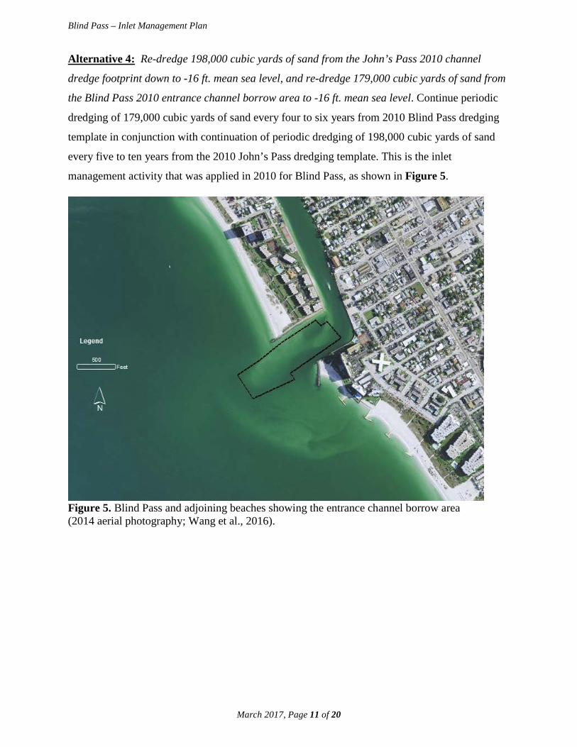
Alternative 4: Re-dredge 198,000 cubic yards of sand from the John’s Pass 2010 channel
dredge footprint down to -16 ft. mean sea level, and re-dredge 179,000 cubic yards of sand from
the Blind Pass 2010 entrance channel borrow area to -16 ft. mean sea level. Continue periodic
dredging of 179,000 cubic yards of sand every four to six years from 2010 Blind Pass dredging
template in conjunction with continuation of periodic dredging of 198,000 cubic yards of sand
every five to ten years from the 2010 John’s Pass dredging template. This is the inlet
management activity that was applied in 2010 for Blind Pass, as shown in Figure 5.
Figure 5. Blind Pass and adjoining beaches showing the entrance channel borrow area (2014 aerial photography; Wang et al., 2016).

Blind Pass – Inlet Management Plan
March 2017, Page 12 of 20
Alternative 5: Extend the south jetty at Blind Pass. This alternative investigates the potential
application of a structural option, as seen in Figure 6.
Figure 6. Graphic illustrating an extension of the south jetty as discussed in Alternative 5 (Wang et al., 2016).

Blind Pass – Inlet Management Plan
March 2017, Page 13 of 20
Alternative 6: Extend both structures at Blind Pass. This alternative investigates an
aggressive structural option, illustrated in Figure 7.
Figure 7. Graphic illustrating an extension of both the Treasure Island terminal groin and the south jetty as discussed in Alternative 6 (Wang et al., 2016).
The following factors were considered in the evaluation of the four inlet management
alternatives for Blind Pass: 1) potential influence on the wave field in the vicinity of the inlet; 2)
potential influence on tidal flow patterns; 3) potential influence on erosion or accretion trends
along the adjacent beaches; 4) potential influences on erosion and deposition patterns in the
channel; 5) potential influences on erosion and deposition patterns over the ebb shoal and
therefore sand bypassing; and 6) for alternatives including dredging, the in-filling rate and
resulting dredging interval.
Alternative 4 involves re-dredging the Blind Pass entrance channel borrow area (see Figure 5)
that was dredged in 2010 and placing the dredged sand on Upham Beach. It also considers the
2010 fill placement north of Blind Pass on Sunset Beach with dredged sand from John’s Pass.
Since there is active sand transport within the Blind Pass entrance channel dredge area, the
infilling rate is relatively high at 35,000 cubic yards per year. The study results determined that
the dredge area would re-fill in six years and therefore would have a six-year maintenance

Blind Pass – Inlet Management Plan
March 2017, Page 14 of 20
dredging requirement. Alternative 4 did not have a significant adverse influence on either the
ebb or flood tidal flow patterns through the inlet and over the ebb shoal, as compared to the
baseline case. The dredging had only a minor influence on the nearshore wave field along the
adjacent beaches. Alternative 4 was subsequently recommended as the management option for
Blind Pass.
Alternatives 5 and 6 involved structural modifications to the terminal groin north of Blind Pass
and the jetty on the south side of Blind Pass. Alternative 5 (Figure 6) extended the south jetty by
230 feet. Alternative 5 was determined to have minimal influence on the hydrodynamics and
morphodynamics of the inlet and adjacent beaches, and therefore, was not recommended as an
inlet management option because its cost could not be justified by its minimal benefits.
Alternative 6 extended the terminal groin north of Blind Pass and the Blind Pass south jetty by
230 feet each, and like Alternative 5, did not involve any dredging or fill placement.
Alternative 6 was determined to have a significant beneficial influence on the tidal flow patterns
through the inlet channel. However, based on model output, the flow changes did not result in
significantly different channel infilling rates; therefore, maintenance dredging would still be
necessary. The extended terminal groin and south jetty might result in development of an
impoundment fillet on the adjacent beaches, and consequently, some accretion at Upham Beach.
However, these extensions may have negative effects on beaches farther away from the inlet on
Long Key. Alternative 6 was therefore not recommended because the benefit did not appear to
justify the high cost of jetty construction and the potential adverse impact on the beaches south
of Blind Pass.
Updated Sediment Budget through 2015 (Wang et al, 2016)
Pursuant to Section 161.142, Florida Statutes, dredging within an inlet system, including its
shoals, should result in the placement of all beach quality sand on adjacent eroding beaches to
balance the sediment budget between the inlet and adjacent beaches. A sediment budget is a
balance of the volumes (or volume rate of change) for sediments entering and leaving a tidal inlet
system and its adjacent beaches. A sediment budget quantifies the natural longshore sediment
transport by waves and tides to and from the inlet, the entrapment of longshore sediment by the
inlet channel and the ebb and flood shoals, and the mechanical “bypassing” of sediment,
typically by a hydraulic dredge, from the inlet to the adjacent beaches or nearshore. Sediment
transport volumes and pathways are unique to each inlet as influenced by regional geology,

Blind Pass – Inlet Management Plan
March 2017, Page 15 of 20
morphological characteristics, wave and tide conditions, and sediment characteristics and supply.
A sediment budget is determined by comparing two or more surveys of an inlet system,
including its channel, ebb and flood shoals, and the adjacent beaches. The inlet management
study for Blind Pass conducted an updated survey in 2014 of the inlet system to compare with a
prior survey in 2010 (Figure 8).
Figure 8. Blind Pass channel and ebb shoal surveyed in 2014 using a multi-beam system (Wang et al., 2016). Inlet sediment management requires implementation of sediment bypassing protocols that are
based on the latest available data and analysis in order to balance the sediment budget. An
updated sediment budget for Blind Pass was developed for the period between 2010 and 2014
after the last dredging at both John’s Pass and Blind Pass in 2010 and associated beach
nourishment on Treasure Island and Long Key, and before the beach nourishments on Treasure
Island and Long Key in 2014 (Wang et al., 2016). In addition, Sand Key beach to the north of
the John’s Pass and Blind Pass system was nourished in 2012. Therefore, this updated sediment
Blind Pass – Inlet Management Plan
March 2017, Page 16 of 20
budget is influenced by the artificial sand supply from the 2010 Treasure Island and Long Key
beach nourishments and 2012 Sand Key nourishment. Since the beaches in the study area are
nourished regularly and the budget period incorporates a large portion of a beach nourishment
cycle, this updated sediment budget should represent a typical situation inclusive of artificial
sand supplies from beach nourishments. For this sediment budget, the coast directly affected by
Blind Pass has been divided into the beach and inlet cells as shown in Figure 9. Beach erosion
and accretion have been measured by comparing the surveys of October 2010 and June 2014,
which has yielded the volume losses and gains for each of the beach and inlet cells.
To the north of Blind Pass, Sunset Beach between R140 and R143 lost an annualized 12,000
cubic yards per year of sediment between October 2010 and June 2014. During the same period,
to the south of Blind Pass, Upham Beach between R144 and R146 lost an annualized 31,000
cubic yards per year of sediment. These losses were offset by gains within the Blind Pass
system, including the channel and the ebb shoal. Specifically, the Blind Pass channel from the
entrance at the inlet jetties, extending into the inlet interior, saw an annualized gain during the
same period of 31,000 cubic yards per year of sediment. Outside the entrance to Blind Pass, i.e.,
the ebb shoal, there was an annualized gain for the same period of 68,000 cubic yards per year.
Combining the Blind Pass channel and ebb shoal gains equals 99,000 cubic yards per year,
which is more than double the 43,000 cubic yards per year needed to offset the losses north and
south of Blind Pass. The Blind Pass entrance channel borrow area, which includes the channel
between the terminal groin north of Blind Pass and the Blind Pass south jetty and extending
offshore approximately 500 feet as discussed in alternative 4 (see Figure 5), holds a sufficient
quantity of beach quality sand to be periodically dredged and placed north and south of Blind
Pass. An annualized excess of sediment gained within the ebb shoal of about 56,000 cubic yards
per year may be expected to substantially contribute to the growth of the ebb shoal. Over time,
as the ebb shoal continues to grow, notwithstanding the removal of 43,000 cubic yards per year
from the Blind Pass entrance channel borrow area, natural bypassing of sediment may be
expected to increase to Upham Beach to the south of Blind Pass. The enhancement of natural
bypassing would reduce the cost of maintaining the beach nourishment of Long Key using
mechanical sand bypassing.

Blind Pass – Inlet Management Plan
March 2017, Page 17 of 20
Figure 9. Annualized sediment budget at Blind Pass based on field data collected from October 2010 to June 2014 (aerial photography 2014; Wang et al., 2016).

Blind Pass – Inlet Management Plan
March 2017, Page 18 of 20
Recommended Inlet Management Plan Strategies
The Department staff recommends the following inlet management strategies be adopted to meet
the requirements of Chapter 161, Florida Statutes. Future inlet management activities shall be
consistent with the following four strategies.
1) A comprehensive beach and inlet hydrographic monitoring program shall be
conducted to evaluate the performance and impact of existing sand bypassing and
nourishment projects and to periodically update the inlet sediment budget.
Discussion – A comprehensive beach and inlet hydrographic monitoring program is the most
important element to manage the sediment at Blind Pass. Topographic and bathymetric surveys
provide reliable data to estimate the volumetric impact of the inlet on adjacent beaches and to
establish a sand placement protocol that complies with Section 161.142, Florida Statutes. The
current approved inlet monitoring program conducted by Pinellas County provides sufficient
monitoring data.
2) Sand bypassing shall be performed from the Blind Pass entrance channel borrow
area to the adjacent gulf-fronting beaches both to the north and to the south of the
inlet within designated critically eroded areas between FDEP Reference Monuments
R136 and R148. The quantity of fill to be placed in each area shall be based on observed
beach erosion patterns and quantities documented through the monitoring protocol of
Strategy #1 above.
Discussion – The Sunset Beach nourishment project (R136-R143) north of Blind Pass and the
Upham Beach nourishment project (R144-R148) south of Blind Pass are the beach erosion areas
directly impacted by Blind Pass.
3) The initial target inlet sand bypassing quantities shall be 31,000 cubic yards per
year to the south of the inlet and 12,000 cubic yards per year to the north. These
target quantities may be modified based on a minimum of four years of monitoring
indicating a change in the sediment budget. In the interim, should the volume of sand
accumulating in the Blind Pass entrance channel borrow area exceed these quantities, the
additional sand may be dredged and placed on the adjacent beaches to extend the life of
the adjacent beach restoration projects.

Blind Pass – Inlet Management Plan
March 2017, Page 19 of 20
Discussion – Treasure Island (R126-R143) to the north and Long Key (R144-R166) to the south
of Blind Pass are currently designated critically eroded beach segments (FDEP, 2016) and
federally-authorized beach restoration projects.
4) The source of sediment for meeting the target sand bypassing quantities in Strategy
#3 above shall be the Blind Pass entrance channel borrow area. Acceptable beach
quality sand may also be obtained from inland sand mines or offshore sources to
supplement the target sand bypassing quantities or to facilitate development and growth
of the Blind Pass ebb shoal.
Discussion – The area typically dredged for sand bypassing is the Blind Pass entrance channel
borrow area. This does not exclude acceptable quality inland sand mines or offshore sources
when determined necessary to supplement or facilitate the target sand bypassing quantities or
develop the inlet ebb shoal.

March 2017, Page 20 of 20
Blind Pass – Inlet Management Plan
References
Florida Department of Environmental Protection, 2015. Strategic Beach Management Plan,
Division of Water Resource Management, 365p.
Florida Department of Environmental Protection, 2016. Critically Eroded Beaches in Florida,
Division of Water Resource Management, 88p.
Mehta, A.J., Jones, C.P., and Adams, W.D., 1976. John’s Pass and Blind Pass: Glossary of
Inlets Report Number 4, Florida Sea Grant Program, 66 p.
U.S. Army Corps of Engineers, 1966. Beach Erosion Control Study on Pinellas County, Florida,
Jacksonville District, 108 p.
Wang, P., Horwitz, M.H., and Cheng, J., 2016. Inlet Management Study for John’s Pass and
Blind Pass, Pinellas County, Florida, University of South Florida, Coastal Research
Laboratory, 300 p.