Embed Size (px)
Citation preview

BISHAN-ANG MO KIO PARKFROM CONCRETE CANAL TO NATURAL WONDERLAND
Chloe Schaefer | Professor Spirn | Ecological Urbanism | December 2014

Abstract Despite being an island surrounded by water, it seems there are few places where residents of Singapore can actually interact with water. Bishan-Ang Mo Kio Park is one of them. This paper examines how the river was naturalized and the park was transformed as part of Singapore’s Active, Beautiful, Clean Waters Programme (ABC Waters). The naturalized channel carries the Kallang River, which runs from the Lower Pierce Reservoir to the Marina Reservoir (previously the ocean) and now serves multiple purposes: flood control, water purification, aesthetic enjoyment, and recreational and educational opportunities. The redesign of the park contains the use of natural processes for flood and soil erosion control, with a new floodplain design and soil bioengineering. Natural processes and materials are also used for water treatment and filtration with the creation of a cleansing biotope, an artificial wetland that treats and purifies the water of the river through the use of selected plants, and a network of vegetated bioswales.
While this project is successful in Singapore, and parts of it are in fact already being replicated throughout the country, it is important to note that Singapore has an unusual political environment. This is not to say that this project cannot be replicated elsewhere—the techniques and elements certainly could be—but, it may be more difficult in a place where the government has not made it a national priority to be a “City of Gardens and Water.”
1

Singapore Singapore is an island city-state located at the very southern tip of the Malaysian peninsula. Formerly a British colony, Singapore became part of Malaysia in 1963, and then became fully independent in 1965. The country today is a relatively wealthy, capitalist economy, with one of the highest GDPs per capita in the world. Singapore is technically a parliamentary republic with elections. However, the same political party, the People’s Action Party (PAP), has held the majority in parliament for several decades. Many parts of life in Singapore are highly regulated and governed, and it is ranked as only “Partly Free” by the Freedom House rankings on political freedom and civil liberties (Freedom House, 2014). Although freedom of speech and freedom of the press may be somewhat restricted, Singaporeans enjoy a high standard of living. While the programs and projects discussed in this paper generally seem praise-worthy, it is important to note that, likely due to the political environment in Singapore, it was virtually impossible to find any documents critical of these programs and projects.
Singapore is relatively small in size with an area of about 700 square kilometers, approximately three and a half times the size of Washington D.C. (Central Intelligence Agency, n.d.). The population is rather large, with over 5 million people (Central Intelligence Agency, n.d.), thus development in the city-state is very dense. Traditionally, development has occurred in such a way as to separate the more wild areas from the developed ones, confining the “wild” to nature reserves such as Bukit Timah. Many open spaces throughout the housing areas are well manicured and covered with lawns. Singapore has a wet and tropical climate, and receives significant amounts of rain each year—approximately 2,400 mm. However, Singapore has not yet been able to capture a sufficient amount of rainwater to meet its water demand when coupled with its other domestic water sources (Dreiseitl, 2007). Thus, Singapore currently imports 40% of its water from Malaysia, a situation Singapore would like to change (Dreiseitl, 2007).
Currently Singapore describes its water supply through the idea of four national taps: imported water from the Johor River (purchased from Malaysia), desalinated water, NEWater (a technology that purifies and recycles water), and local catchment water (PUB, Singapore, 2013b). If imported water makes up 40% of the supply, approximately 20% comes from local water catchments, which now make up two-thirds of Singapore’s land area (PUB, Singapore, 2013b).
With so much rain, and so much developed land, risk of flooding is high. Throughout the first decades of independence, Singapore set up a sophisticated drainage system to move water as quickly as possible away from development and into the ocean through a vast network of concrete canals and drains. This system is currently made up of 32 rivers, 17 reservoirs, and over 8,000 kilometers of waterways (PUB, Singapore, 2013b).
Malaysia
Singapore
Original Photo: NASA GSFC Landsat/LDCM EPO Team. It has been modified.
2
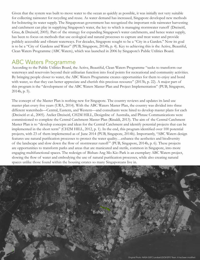
Given that the system was built to move water to the ocean as quickly as possible, it was initially not very suitable for collecting rainwater for recycling and reuse. As water demand has increased, Singapore developed new methods for bolstering its water supply. The Singaporean government has recognized the important role rainwater harvesting and catchment can play in supplying Singapore’s water, the key to which is managing stormwater runoff (Dreiseitl, Grau, & Dreiseitl, 2005). Part of the strategy for expanding Singapore’s water catchments, and hence water supply, has been to focus on methods that use ecological and natural processes to capture and treat water and provide publicly accessible and vibrant waterways. For decades, Singapore sought to be a “City in a Garden.” Now its goal is to be a “City of Gardens and Water” (PUB, Singapore, 2014b, p. 4). Key to achieving this is the Active, Beautiful, Clean Waters Programme (ABC Waters), which was launched in 2006 by Singapore’s Public Utilities Board.
ABC Waters ProgrammeAccording to the Public Utilities Board, the Active, Beautiful, Clean Waters Programme “seeks to transform our waterways and reservoirs beyond their utilitarian function into focal points for recreational and community activities. By bringing people closer to water, the ABC Waters Programme creates opportunities for them to enjoy and bond with water, so that they can better appreciate and cherish this precious resource” (2013b, p. 22). A major part of this program is the “development of the ABC Waters Master Plan and Project Implementation” (PUB, Singapore, 2014b, p. 5).
The concept of the Master Plan is nothing new for Singapore. The country reviews and updates its land use master plan every five years (URA, 2014). With the ABC Waters Master Plan, the country was divided into three different watersheds—Central, Eastern, and Western—and consultants were hired to develop master plans for each (Dreiseitl et al., 2005). Atelier Dreiseitl, CH2M HILL, DesignInc of Australia, and Phrase Communications were commissioned to complete the Central Catchment Master Plan (Rinaldi, 2013). The aim of the Central Catchment Master Plan is to “develop concepts and ideas for the Central Catchment and identify potential projects that can be implemented in the short term” (CH2M HILL, 2012, p. 1). In the end, this program identified over 100 potential projects, with 23 of them implemented as of June 2014 (PUB, Singapore, 2014b). Importantly, “ABC Waters design features use natural purification processes to protect the water quality…enhance the aesthetics and biodiversity of the landscape and slow down the flow of stormwater runoff ” (PUB, Singapore, 2014b, p. 6). These projects are opportunities to transform parks and areas that are manicured and sterile, common in Singapore, into more engaging multifunctional spaces. The redesign of Bishan-Ang Mo Kio Park is an exemplary ABC Waters project, slowing the flow of water and embodying the use of natural purification processes, while also creating natural spaces unlike those found within the housing estates so many Singaporeans live in.
Ang Mo Kio
Bishan
Original Photo: NASA GSFC Landsat/LDCM EPO Team. It has been modified.
3

Bishan-Ang Mo Kio Park The 62-hectare Bishan-Ang Mo Kio Park, first opened in 1988, is located between the two housing estates of Bishan and Ang Mo Kio, in the central area of the island. It is located north of the Central Business District and just east of the Central Water Catchment, next to the Lower Pierce Reservoir. It is about one-sixth the size of Central Park, or about twice the size of the Boston Common and Public Garden combined (Central Park Conservancy, 2014; Friends of the Public Garden, n.d.). It is enclosed on its northern edge by Ang Mo Kio Avenue 1, on its southern edge by Sin Ming Ave and Bishan Street 22, on its eastern side by Bishan Road, and on its western side by Upper Thomson Road. Marymount Road bisects the park. It is surrounded by high density residential developments.
The Kallang River, which runs for 10 kilometers from the Lower Pierce Reservoir to the newly completed Marina Reservoir, originally ran through the park for 2.7 kilometers in a straight concrete channel along the Southern edge of the park, blocked off from people by fences (“Cities of the Future,” 2012). Despite the barriers, the canal still attracted residents, especially children, who would climb into the canals to play. Once someone was in the canals, the fences made it difficult to exit, sometimes dangerously trapping children in the canals with rising water levels (Dreiseitl, 2012).
The park was and remains very popular, attracting over three million visitors annually (Rinaldi, 2013). By the early 2000s, it was in need of significant maintenance and repair especially with regard to drainage problems and the concrete canal, parts of which were crumbling (Rinaldi, 2013). Thus, as part of the ABC Waters Programme, this park was slated for redesign. PUB and Singapore’s National Parks Service (NParks) teamed up with the design firm Atelier Dreiseitl and the engineering firm CH2M HILL to redesign the park. Both firms had been involved with carrying out the Central Catchment Area Master Plan.
While there are many intriguing aspects of the redesign of Bishan Ang Mo Kio Park, completed in March 2012, this paper focuses on the use of natural processes and materials to provide flood control, erosion control, water purification, and water filtration, and the community’s interaction and engagement with the park. Flood ControlWhile the concrete canal that was originally in the park may not have seemed pleasant or aesthetically nice, it was functional. The “Kallang River was engineered into a concrete canal to efficiently convey storm water from the rapidly urbanizing satellite towns of Bishan and Ang Mo Kio in the 1960s. In 1988, the park was built around the canal but the two were never fully integrated because concrete canals convey water at high velocities during storm events but were also a safety hazard during periods of rain” (“Kallang River Bishan Park,” 2014). The redesign sought to keep the functionality, but also to bring the river into the park, where park goers could easily and safely interact with the water.
“Bef
ore
and
Aft
er A
eria
l Vie
w o
f Kal
lang
Riv
er”
by
Pag
od
asho
pho
use.
- O
wn
wo
rk..
Lice
nsed
und
er C
reat
ive
Co
mm
ons
Att
ribut
ion-
Shar
e A
like
3.0
via
Wik
imed
ia C
om
mo
ns -
http
://c
om
mo
ns.w
ikim
edia
.org
/wik
i/Fi
le:B
efo
re_a
nd_
Aft
er_A
eria
l_V
iew
_of_
Kal
lang
_Riv
er.jp
g#m
edia
view
er/F
ile:B
efo
re_a
nd_A
fter
_A
eria
l_V
iew
_of_
Kal
lang
_Riv
er.jp
g
Before After4

Rather than another 24-meter wide concrete channel, the new design is based on the idea of using the parkland to serve as a flood plain (Rinaldi, 2013). When little water is running through the river, the riverbanks, which are covered in vegetation and grass, provide recreational areas. When water levels are high, the surrounding parkland is inundated and serves as flood zones. During these times, most people would not be in the park anyway, so the limited parkland is not an issue (Dreiseitl, 2012). This new design not only allows for multiple uses of the space in the park, with more opportunities for park goers to interact with the water, but it also provides even greater flood prevention, with the ability to carry 40% more water than the previous channel (“Kallang River Bishan Park,” 2014). The meandering of the river lengthened the channel in the park from 2.7 kilometers to 3.2 kilometers. The longer course helps slow the flow of water through the park, aiding in water treatment, filtration, and safety (Rinaldi, 2013).
Concern over water safety fueled a debate about incorporating barriers into the redesigned river as there had been previously. “‘The biggest challenge we had to face as designers, up until the final stages of the project, was fear of water,’ Dreiseitl says” (Rinaldi, 2013, p. 87). Rather than constructing fences or barriers to the river, however, the designers worked with the government to engage the public in the creation of a river monitoring and warning system. The system is comprised of red markers throughout the park that show where the maximum water levels are and hence indicate safe higher ground. When sensors detect that water levels are rising rapidly, threatening the safety of park goers, warnings are issued via loudspeakers and flashing lights. There are also warning signs throughout the park in multiple languages, reflecting the many languages spoken in Singapore (Rinaldi, 2013).
After with rain
“Kal
lang
Riv
er a
fter
Rai
n” b
y Pa
go
das
hop
hous
e - O
wn
wo
rk. L
icen
sed
und
er C
reat
ive
Co
mm
ons
A
ttrib
utio
n-Sh
are
Alik
e 3.
0 vi
a W
ikim
edia
Co
mm
ons
- ht
tp:/
/co
mm
ons
.wik
imed
ia.o
rg/w
iki/
File
:Kal
lang
_Ri
ver_
afte
r_Ra
in.J
PG#m
edia
view
er/F
ile:K
alla
ng_R
iver
_aft
er_R
ain.
JPG
Safety Marker
5
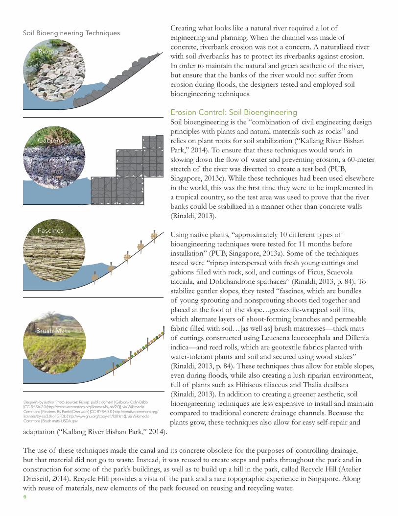
Creating what looks like a natural river required a lot of engineering and planning. When the channel was made of concrete, riverbank erosion was not a concern. A naturalized river with soil riverbanks has to protect its riverbanks against erosion. In order to maintain the natural and green aesthetic of the river, but ensure that the banks of the river would not suffer from erosion during floods, the designers tested and employed soil bioengineering techniques.
Erosion Control: Soil BioengineeringSoil bioengineering is the “combination of civil engineering design principles with plants and natural materials such as rocks” and relies on plant roots for soil stabilization (“Kallang River Bishan Park,” 2014). To ensure that these techniques would work in slowing down the flow of water and preventing erosion, a 60-meter stretch of the river was diverted to create a test bed (PUB, Singapore, 2013c). While these techniques had been used elsewhere in the world, this was the first time they were to be implemented in a tropical country, so the test area was used to prove that the river banks could be stabilized in a manner other than concrete walls (Rinaldi, 2013).
Using native plants, “approximately 10 different types of bioengineering techniques were tested for 11 months before installation” (PUB, Singapore, 2013a). Some of the techniques tested were “riprap interspersed with fresh young cuttings and gabions filled with rock, soil, and cuttings of Ficus, Scaevola taccada, and Dolichandrone spathacea” (Rinaldi, 2013, p. 84). To stabilize gentler slopes, they tested “fascines, which are bundles of young sprouting and nonsprouting shoots tied together and placed at the foot of the slope…geotextile-wrapped soil lifts, which alternate layers of shoot-forming branches and permeable fabric filled with soil…[as well as] brush mattresses—thick mats of cuttings constructed using Leucaena leucocephala and Dillenia indica—and reed rolls, which are geotextile fabrics planted with water-tolerant plants and soil and secured using wood stakes” (Rinaldi, 2013, p. 84). These techniques thus allow for stable slopes, even during floods, while also creating a lush riparian environment, full of plants such as Hibiscus tiliaceus and Thalia dealbata (Rinaldi, 2013). In addition to creating a greener aesthetic, soil bioengineering techniques are less expensive to install and maintain compared to traditional concrete drainage channels. Because the plants grow, these techniques also allow for easy self-repair and
adaptation (“Kallang River Bishan Park,” 2014).
The use of these techniques made the canal and its concrete obsolete for the purposes of controlling drainage, but that material did not go to waste. Instead, it was reused to create steps and paths throughout the park and in construction for some of the park’s buildings, as well as to build up a hill in the park, called Recycle Hill (Atelier Dreiseitl, 2014). Recycle Hill provides a vista of the park and a rare topographic experience in Singapore. Along with reuse of materials, new elements of the park focused on reusing and recycling water.
Riprap
Soil Bioengineering Techniques
Gabions
Fascines
Brush Mats
Diagrams by author. Photo sources: Riprap: public domain | Gabions: Colin Babb [CC-BY-SA-2.0 (http://creativecommons.org/licenses/by-sa/2.0)], via Wikimedia Commons | Fascines: By Paebi (Own work) [CC-BY-SA-3.0 (http://creativecommons.org/licenses/by-sa/3.0) or GFDL (http://www.gnu.org/copyleft/fdl.html)], via Wikimedia Commons | Brush mats: USDA.gov
6

Water Treatment: Cleansing BiotopeNatural processes and techniques were not only used to control the path of water, but also to treat it. The largest piece of the natural water purification and treatment system in the park is the cleansing biotope. This is an artificial wetland made up of 15 different cells and four terraces that purifies the river water and runoff (PUB, Singapore, 2014b). The substrates of the wetland cells are generally nutrient poor and planted with specific wetland plants selected for their ability to clean water of contaminants such as phosphorous, nitrogen, or copper (PUB, Singapore, 2014b). “The layers of substrate filter out particulates and have mineral composites that bind and remove phosphates. The dense planting also filters out sediment while partially feeding off and removing nitrates in the water” (PUB, Singapore, 2014b, p. 44). The cleansing biotope in Bishan-Ang Mo Kio Park contains plants such as
Equisetum hyemale, Cyperus alternifolius, Portulaca orleracea, and Cyperus haspan (NParks, Singapore, 2013). After the surface runoff and river water are channeled through multiple wetland cells, the water is subjected to an ultraviolet treatment to remove bacteria. The water is then returned to the pond system and the river in the park, or it is channeled to a water playground in the park (NParks, Singapore, 2013).
Cleansing Biotope
Cleansing Biotope Cell
Filter Substrate
Plants
Riverwash Gravel
Round Gravel
Multi-layered Liner
Compacted Soil
Diagram adapted by author from ABC Waters Design Guidelines, p. 44
7

Water Filtration: Vegetated BioswalesThe other primary way in which water is filtered on site at the park is through the use of a network of vegetated bioswales. Vegetated bioswales are natural drainage channels located on mild slopes. They are lined with rocks and plants to slow the flow of water and capture sedimentation. “Vegetated swales alone usually cannot provide sufficient treatment to meet the stormwater treatment or water quality objectives as it has limited capability to remove soluble nutrients. However, vegetated swales are particularly good at removing coarse sediments and can provide the necessary pre-treatment for downstream treatment systems such as wetlands and bioretention systems” (PUB, Singapore, 2014b, p. 34). These bioswales help capture storm water runoff from the surrounding area, filtering it to some extent, and then channeling it into the river. Some of the plants used in the swales in Bishan-Ang Mo Kio Park are Bacopa monnieri (water hyssop), which works to filter cadmium and lead from the water, and Cymbopogon citratus (lemongrass), which works as a mosquito repellent. In Singapore, repelling mosquitos is not a benefit, but a necessity.
Filtrate
FiltrateFiltrate
Filtrate
Surface Runoff
TreatedWater
Diagram adapted by author from ABC Waters Design Guidelines, pp. 43
Cleansing Biotope Process Overflow
Vegetated Bioswale
8

Mosquito ControlGiven its wet, tropical climate, Singapore is a breeding ground for mosquitos, which can carry Dengue fever. There exists a large campaign to prevent the Dengue-carrying Aedes mosquito from breeding, mainly in containers located in people’s homes (National Environment Agency, Singapore, 2013). Because the only way to prevent Dengue is to prevent mosquito breeding, mosquitos must also be controlled in water features to effectively prevent the disease. The ABC Waters Design Guidelines, which provides guidance for designing and redesigning waterways in Singapore today, lays out strict requirements for projects regarding mosquito control. “The ABC Waters design features have to be designed to prevent mosquito breeding by eliminating conditions that are favourable for mosquito breeding” (PUB, Singapore, 2014b, p. 16). Methods for doing this include reviewing plant selection during the design process to avoid plants that serve as mosquito breeding grounds, and minimum weekly surveillance to identify and destroy any potential mosquito habitats, both above ground and in drain pipes, to ensure no stagnant water exists (PUB, Singapore, 2014b). Additionally, water must filter through bioretention systems with a constant flow and in a timely manner, and these systems must also be monitored regularly. In addition to monitoring, measures can also be taken such as introducing fish that will control mosquito larva into water bodies. Because this is a known problem in Singapore, it is likely something that the redesign of Bishan-Ang Mo Kio Park strictly adhered to both in its planning process and its ongoing maintenance.
Community EngagementBoth for maintaining the park today, and throughout its redesign, the park has engaged the community. Community engagement and public participation in the design process is a rather new concept in Singapore, but it was part of the redesign of the park (“Kallang River Bishan Park,” 2014). While the test bed was in process, children were invited to come and learn about the different flora and fauna of the stream, and to touch and experience the water. The children also made sculptures that were then included in the playground, with the hope of creating a sense of ownership and deeper connection to the park (Dreiseitl, 2012; Hauber, 2014). This sense of ownership has spread to include all ages. Now that the park is open, several groups such as Friends of Kallang River @ Bishan-Ang Mo Kio Park (FOBP) work to keep it clean and to educate others about the impacts people have on waterways (PUB, Singapore, 2013a).
The park is also now used for education in the more formal sense, frequently used as a classroom for surrounding schools and students. The ABC Waters Learning Trails Program is an example of how this has become institutionalized. A program of the PUB, the ABC Waters Learning Trails “is a series of place-based trails which encourage students to explore, discover and learn at ABC Waters sites” (PUB, Singapore, 2014a). The trail is interactive and hands-on, and teaches children about Singapore’s water system using real-world examples in Bishan-Ang Mo Kio Park. The trail provides educational opportunities on subjects ranging from biodiversity and conservation to water quality and human stewardship of Singapore’s waters. In addition to the learning trail, several nearby schools are creating their own trails and using the park as a basis for learning about science and geography. One school, Guangyang Secondary School, uses the park for teaching multiple disciplines ranging from English to mathematics to information and communication technology. “The trail uses the park’s physical environment to learn about subjects that are normally carried out within the four walls of a classroom” (PUB, Singapore, 2013a). Programs such as these utilize the park for purposes beyond recreation and facilitate greater connections not only to the park, but also to the natural systems of Singapore.
A Success? Can the redesign and transformation of Bishan-Ang Mo Kio Park be considered a success? Given the information available, the answer would seem to be yes. The redesign of the river has created a place where people can interact and play with water in a safe manner. Although beauty is in the eye of the beholder, it is probably safe to say that the new meandering river is more aesthetically pleasing than the previous concrete channel, and it allows for greater hands-on experiences with the water, plants, and animals. Additionally, the park has been successful in using natural processes to filter, convey, and treat the water, aiding Singapore’s goal of increased sustainable rainwater catchment.
9
BiodiversityAnother success is that the naturalization of the river and redesign of the park has increased its biodiversity. Although it seems there is still a significant amount of lawn and grass in the park, something which seems common in parks throughout Singapore, it is estimated that biodiversity has increased 30% since the redesign (Hauber, 2014). The park now has over 60 species of wildflower, more than 50 species of bird, and over 20 species of dragonfly, some of which are rare to see outside of a nature reserve (“Cities of the Future,” 2012). Larger fauna such as otters, also unusual to see within an urban environment, have been spotted in the river (Hauber, 2014). Not only has the river been better integrated into the park, but the park also serves to integrate humans with the flora and fauna of Singapore.
These interactions are exciting, but they can also be potentially dangerous, such as when a wild boar from the adjoining Lower Pierce natural area wandered into the park and charged at two people (Chia, 2012). Although the people were not seriously injured, it brings to light the tension between humans and other wildlife when land is scarce. A response to this might be to suggest that Singapore revert to designing and building parks that cannot support or attract any animals that may potentially harm people. But rather than an “us versus them” dynamic, this episode could be used as part of an educational opportunity.
Parks should be safe spaces for people, but total segregation of humans and fauna is not the only way of fostering this. Parks that are more “wild” can be used to create awareness for other animals and for how humans should interact with them to keep both parties healthy and safe. Especially “As Singapore becomes more built up, the quality of open spaces and recreational options will be more important than ever,” (PUB, Singapore, 2013c, p. 19) and there will thus be fewer spaces for the striking and exceptional flora and fauna of Singapore. If Singapore is to have both a larger population of people and significant biodiversity, the country will have to create spaces that support both people and animals. Bishan-Ang Mo Kio Park seems to have done this successfully. Another signal that the park redesign is successful is that many of these elements are now standardized and promoted in the ABC Waters Design Guidelines.
ReplicationLaunched in 2009, the ABC Waters Design Guidelines (the Guidelines) provides a toolbox of design elements that can be integrated into both public and private open space designs and developments. The Guidelines standardize and recommend many of the techniques that were new with Bishan-Ang Mo Kio Park, such as soil bioengineering. This document is important because it signals that Bishan-Ang Mo Kio Park should be considered the future standard, not an outlier or an exception. The unique elements of the park can, and should, be replicated elsewhere in Singapore. And in fact, there are several other projects completed or underway that are implementing similar techniques. For example, the Central Green Core @ Cleantech Park has implemented a network of vegetated swales and a cleansing biotope. Sunset Ring at Sungei Ulu Pandan is another park that has a cleansing biotope; Clementi Ring, also part of Sungei Ulu Pandan, has a 20-meter long vegetated swale, and Waterway Ridges @ Punggol East has vegetated swales. There are several other projects that use other natural processes, such as bioretention swales or green roofs (PUB, Singapore, 2014b). Based on these guidelines, it seems that these ideas are taking off in Singapore and will be seen more and more frequently throughout the country.
These elements and techniques can, technically speaking, be carried out not just in Singapore, but also across the world. However, it should be noted that carrying out a similar project in a less affluent country or one with a weaker and less centralized form of government may be more difficult. This not to say similar projects cannot succeed elsewhere, just that strong political and financial support for such a project can help facilitate its completion. From the documents available, it seems there was complete political support for the project and, given the government’s power in Singapore, it is not surprising that it came to fruition. The project also succeeded because different agencies, PUB and NParks, were able to work effectively together. “For the first time, the two agencies worked together to manage the river park, proving to be a good opportunity for both agencies to combine resources and meet their goals of providing outstanding open green spaces for recreation and health while managing Singapore’s 10
water resources effectively” (Hauber, 2014, p. 57). The ease with which this occurred, at least to the outside observer, is not something that is impossible elsewhere, but should not be expected as routine. Again, however, it should be noted that obtaining transparent information regarding Singaporean government proceedings is difficult. There may have been tensions in carrying out this project, but without partaking in the process, it is hard to know.
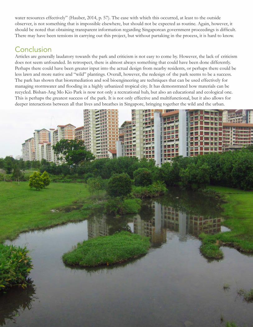
ConclusionArticles are generally laudatory towards the park and criticism is not easy to come by. However, the lack of criticism does not seem unfounded. In retrospect, there is almost always something that could have been done differently. Perhaps there could have been greater input into the actual design from nearby residents, or perhaps there could be less lawn and more native and “wild” plantings. Overall, however, the redesign of the park seems to be a success. The park has shown that bioremediation and soil bioengineering are techniques that can be used effectively for managing stormwater and flooding in a highly urbanized tropical city. It has demonstrated how materials can be recycled. Bishan-Ang Mo Kio Park is now not only a recreational hub, but also an educational and ecological one. This is perhaps the greatest success of the park. It is not only effective and multifunctional, but it also allows for deeper interactions between all that lives and breathes in Singapore, bringing together the wild and the urban.
11
Photos and Diagrams All photos and diagrams are original works by the author unless otherwise noted.
Works Cited Atelier Dreiseitl. (2014). Bishan-Ang Mo Kio Park. Retrieved from
http://www.dreiseitl.com/index.php?id=47&lang=en
Central Intelligence Agency. (n.d.). Singapore. In CIA World Factbook. US Central Intelligence Agency. Retrieved
from https://www.cia.gov/library/publications/the-world-factbook/geos/sn.html
Central Park Conservancy. (2014). Central Park: Park Information. Retrieved from
http://www.centralparknyc.org/about/park-information/
CH2M HILL. (2012). Active, Beautiful & Clean Waters Porgramme Central Catchment Master Plan. CH2M HILL.
Retrieved from https://www.ch2m.com/corporate/worldwide/assets/ProjectPortfolio/asia/CH2M-HILL-
Clean-Waters.pdf
Chia, S. (2012, June 23). Two hurt in wild boar attack in Bishan. Straits Times. Retrieved from
http://global.factiva.com/redir/default.aspx?P=sa&an=STIMES0020120623e86n0001b&cat=a&ep=ASE
Cities of the Future: An Urban River Park Transforms Singapore’s Water Infrastructure. (2012). Green Places, (88),
16–19.
Dreiseitl, H. (2007). New waterscapes for Singapore. Topos: The International Review of Landscape Architecture & Urban
Design, 59, 24–30.
Dreiseitl, H. (2012). My experience of working on the Bishan-Ang Mo Kio Park Project. A + U: Architecture &
Urbanism, 501, 68–68.
Dreiseitl, H., Grau, D., & Dreiseitl, H. (Eds.). (2005). New waterscapes: planning, building, and designing with water
(Expanded and rev. ed.). Basel, Switzerland ; Boston: Birkhauser.
Freedom House. (2014). Freedom in the World 2014. Freedom House. Retrieved from
https://freedomhouse.org/sites/default/files/FIW%202014%20Scores%20-
%20Countries%20and%20Territories.pdf
Friends of the Public Garden. (n.d.). Our Parks. Retrieved from http://friendsofthepublicgarden.org/our-parks/
Hauber, G. (2014, December). It Takes a City to Raise a River Park`. My Liveable City, 54–61.
12
Kallang River Bishan Park. (2014). In World Buildings Directory. Retrieved from
http://www.worldbuildingsdirectory.com/project.cfm?id=3870
National Environment Agency, Singapore. (2013). Prevent Aedes Mosquito Breeding [Government]. Retrieved
from http://www.dengue.gov.sg/subject.asp?id=101
NParks, Singapore. (2013). A Guide to Pond Gardens at Bishan-Ang Mo Kio Park. National Parks Board,
Singapore. Retrieved from http://www.nparks.gov.sg/cms/docs/PondGardens_070612.jpg
PUB, Singapore. (2013a). Kallang River @ Bishan-Ang Mo Kio Park. Public Utilities Board, Singapore.
PUB, Singapore. (2013b). Our Water, Our Future. Public Utilities Board, Singapore. Retrieved from
http://www.pub.gov.sg/mpublications/OurWaterOurFuture/Pages/default.aspx
PUB, Singapore. (2013c, August 14). Kallang River @ Bishan-Ang Mo Kio Park Test Bed [Government]. Retrieved
from http://www.pub.gov.sg/abcwaters/ExploreABCAroundYou/Pages/KallangRiver-BishanPark2.aspx
PUB, Singapore. (2014a). ABC Waters Learning Trails: About Us. Public Utilities Board, Singapore. Retrieved from
http://www.abcwaterslearningtrails.sg/web/about-us.php
PUB, Singapore. (2014b, June 4). Active, Beautiful, Clean Waters Design Guidelines. Singapore Public Utilities
Board. Retrieved from
http://www.pub.gov.sg/abcwaters/abcwatersdesignguidelines/Documents/ABC_DG_2014.pdf
Rinaldi, B. M. (2013). The soft sell: in Singapore, Atelier Dreiseitl has given back a river people can love [Bishan-
Ang Mo Kio Park]. Landscape Architecture Magazine, 103(1), 76–89.
URA. (2014). Master Plan [Government]. Retrieved from http://www.ura.gov.sg/uol/master-plan.aspx?p1=View-
Master-Plan
13


![[SUPP1 - 20] BT/NEWS/PAGES 23/02/12 · Ang Mo Kio Bishan Bukit Panjang Bukit Batok Bukit Timah Jurong West Tuas Ghim Moh Marina South Marina East Kallang ... Frasers](https://img.dokumen.tips/doc/110x75/5f0be7107e708231d432c864/supp1-20-btnewspages-230212-ang-mo-kio-bishan-bukit-panjang-bukit-batok.jpg)